


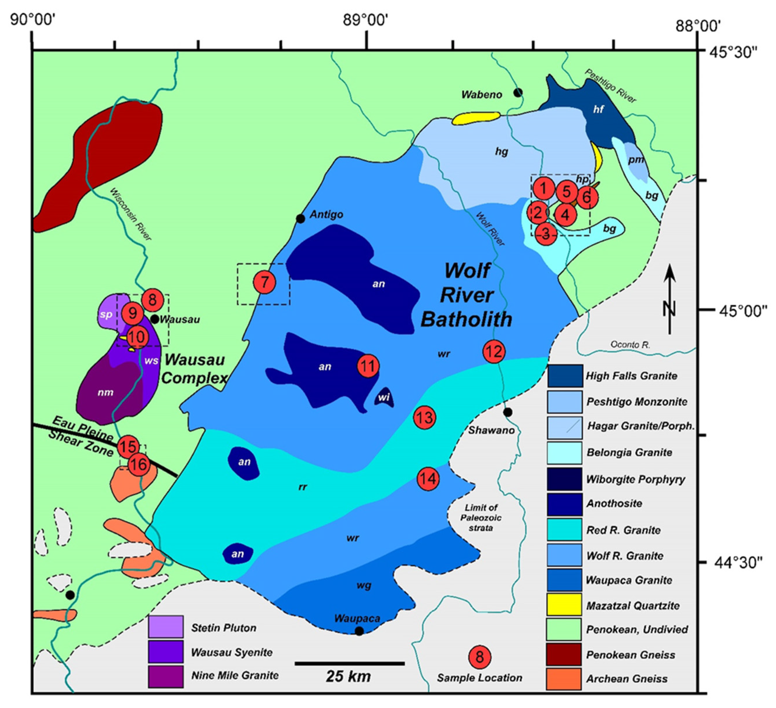
Deformation of the “Anorogenic” Wolf River Batholith, Wisconsin, USA: Understanding the Baraboo Orogeny Hinterland

 ,
,
Abstract
:1. Introduction


| Detrital Zircon | |||||||
|---|---|---|---|---|---|---|---|
| Igneous | Age (Ma) | Orientation | Age Spectra (Ma) | Strain | AMS | Paleopole | Comment |
| Wauson Syenite (Site 9) | 1520 | X | X | ||||
| Bowler Anorthosite (Site 11) | X | X | |||||
| Tigerton Rapalivi Granite (Site 13) | X | X | |||||
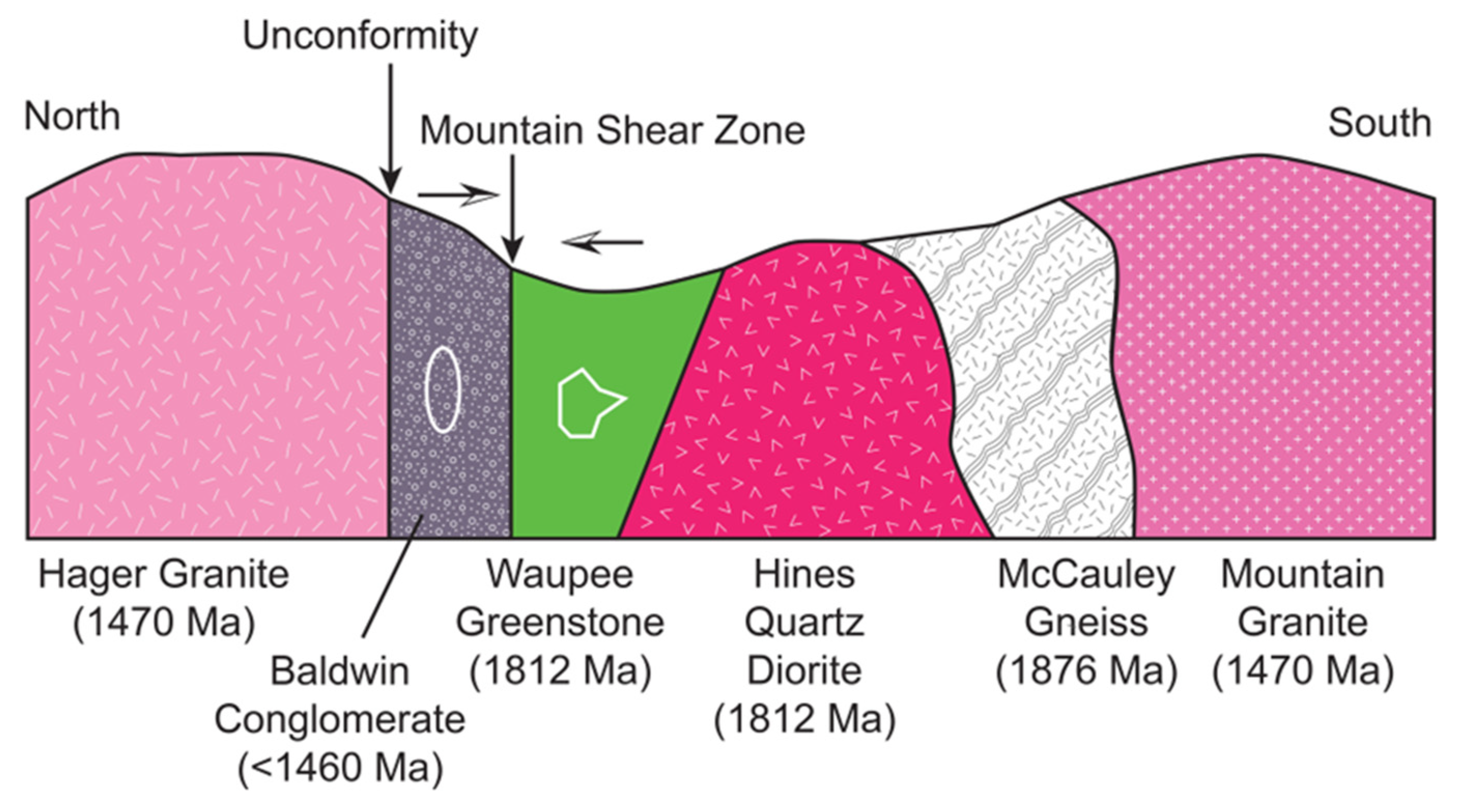
| Mountain Granite (Site 3) | 1470 | X | X | Mountain Shear Zone | |||
| Big Falls Granite (Site 14) | 1468 | X | X | ||||
| Keshena Falls Granite (Site 12) | X | X | |||||
| Badgley Rapids Mangerite (Site 2) | X | X | Crosscutting Pseudotachylite; Mountain Shear Zone | ||||
| Hager Granite (Site 1) | 1470 | X | X | ||||
| Inliers | |||||||
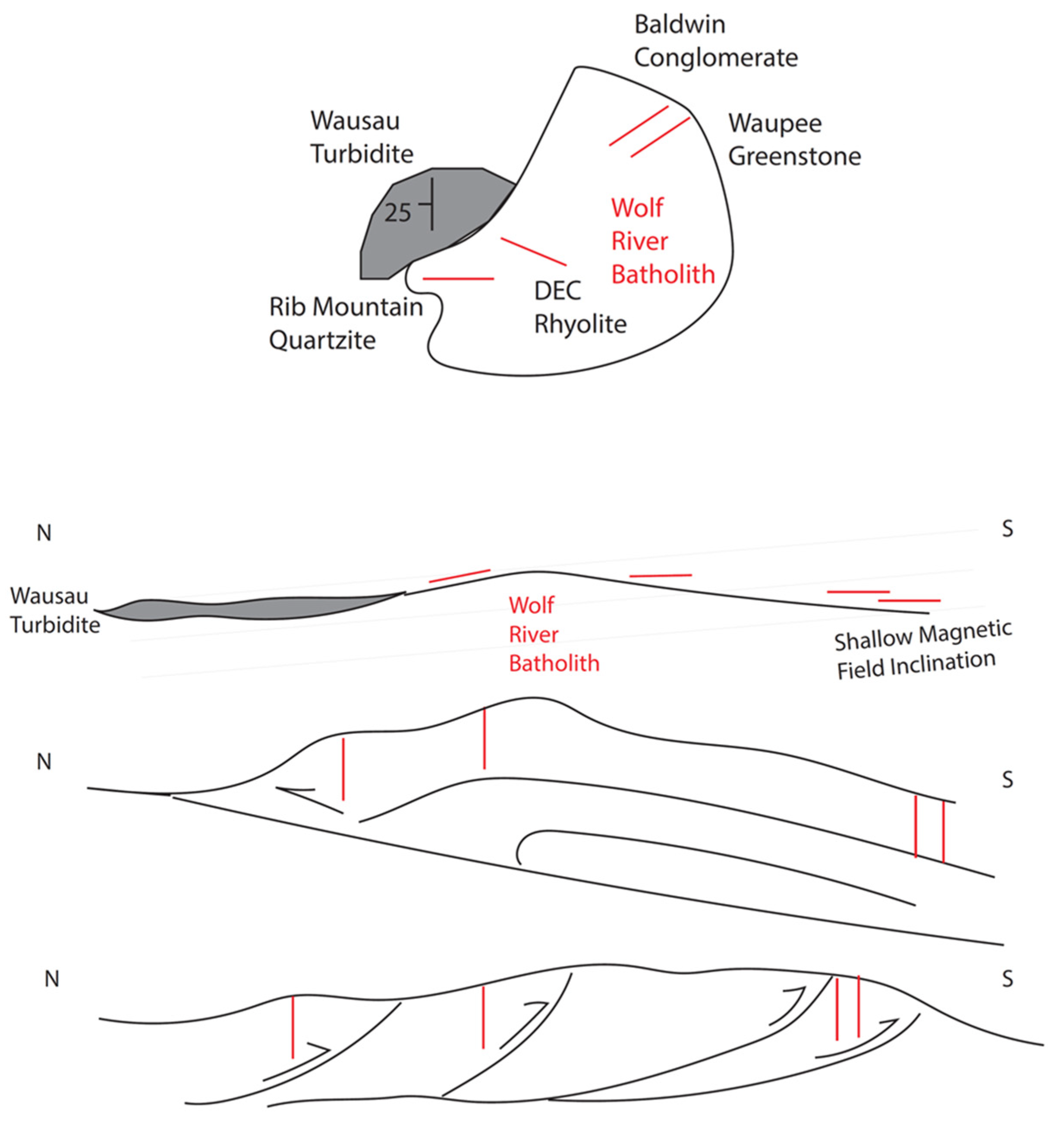
| Rib Mountain Quartzite (Site 10) | MDA | 75°, 90° | 1780, 2650, 3400 | LNS | X | Craddock et al., 2018 [7]; This study | |
| Wausau Turbidite (Site 8) | MDA | 0°, 30° W | 1880 | X | |||
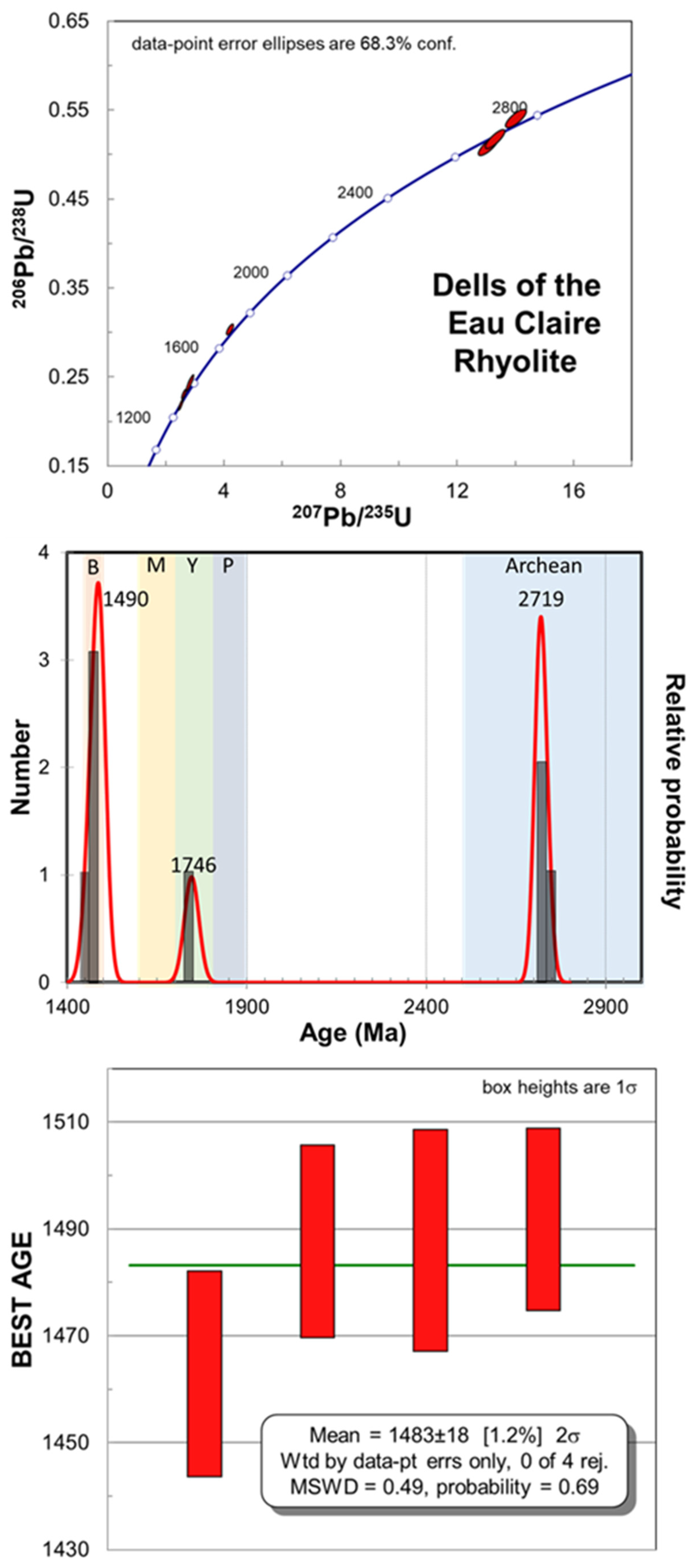
| Dells of Eau Claire Rhyolite (Site 7) | 1470 | 300°, 90° | X | X | Zircon; Monazites in garnet; This study | ||
| Waupee Greenstone (Site 4) | 1812 | 65°, 90° | X | X | Hines Quartz Diorite (1812 Ma); Mountain Shear Zone | ||
| Baldwin Conglomerate (Site 5) | MDA | 65°, 90° | 1460 | LNS | X | Medaris et al., 2021 [2]; Mountain Shear Zone | |
| McCauley Gneiss (Site 6) | 1876 | 65°, 90° | Mountain Shear Zone; This study | ||||
2. Materials and Methods
3. Results
3.1. Local Geology and Geochronology
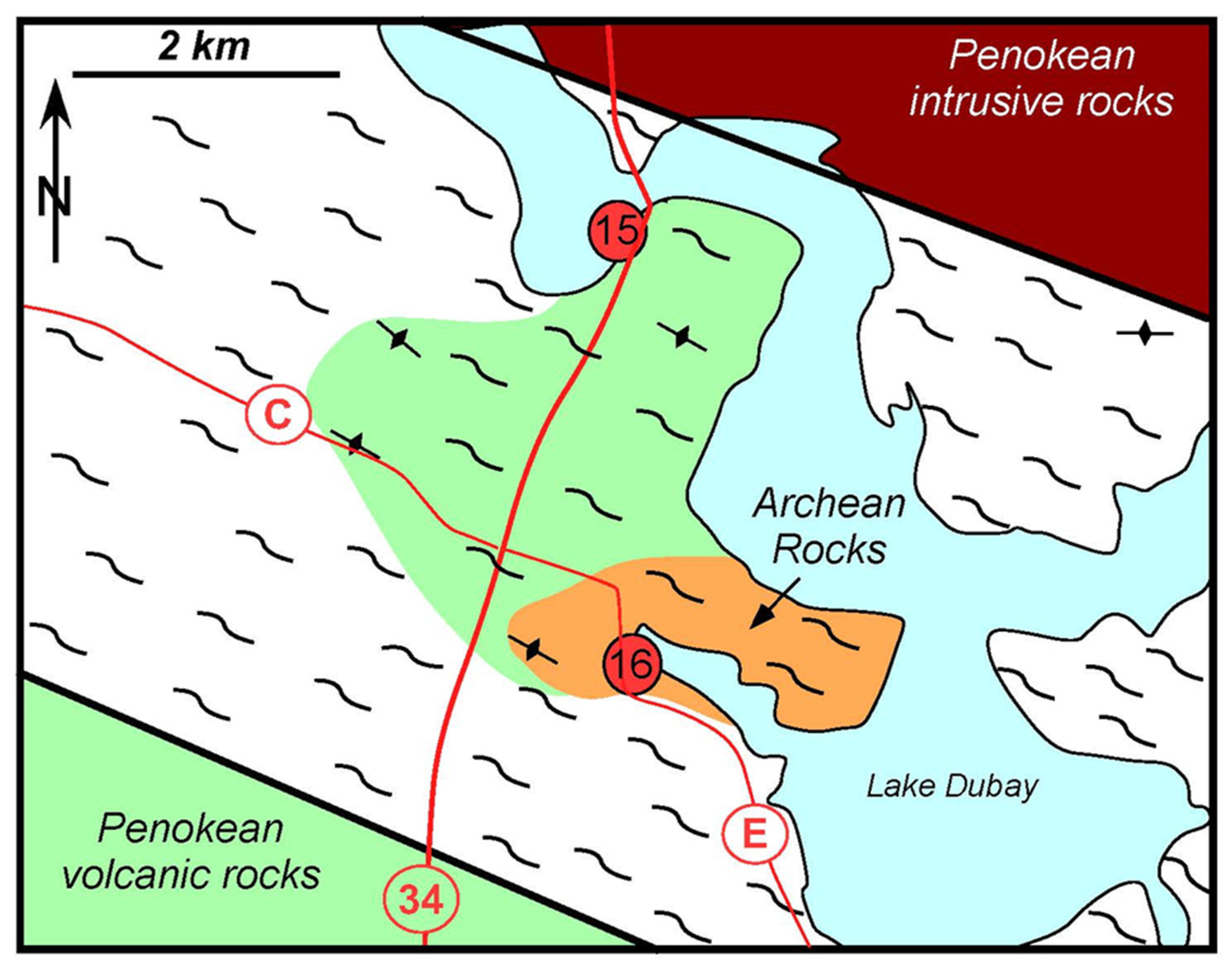
3.1.1. Eau Pleine Shear Zone (Sites 15 and 16)
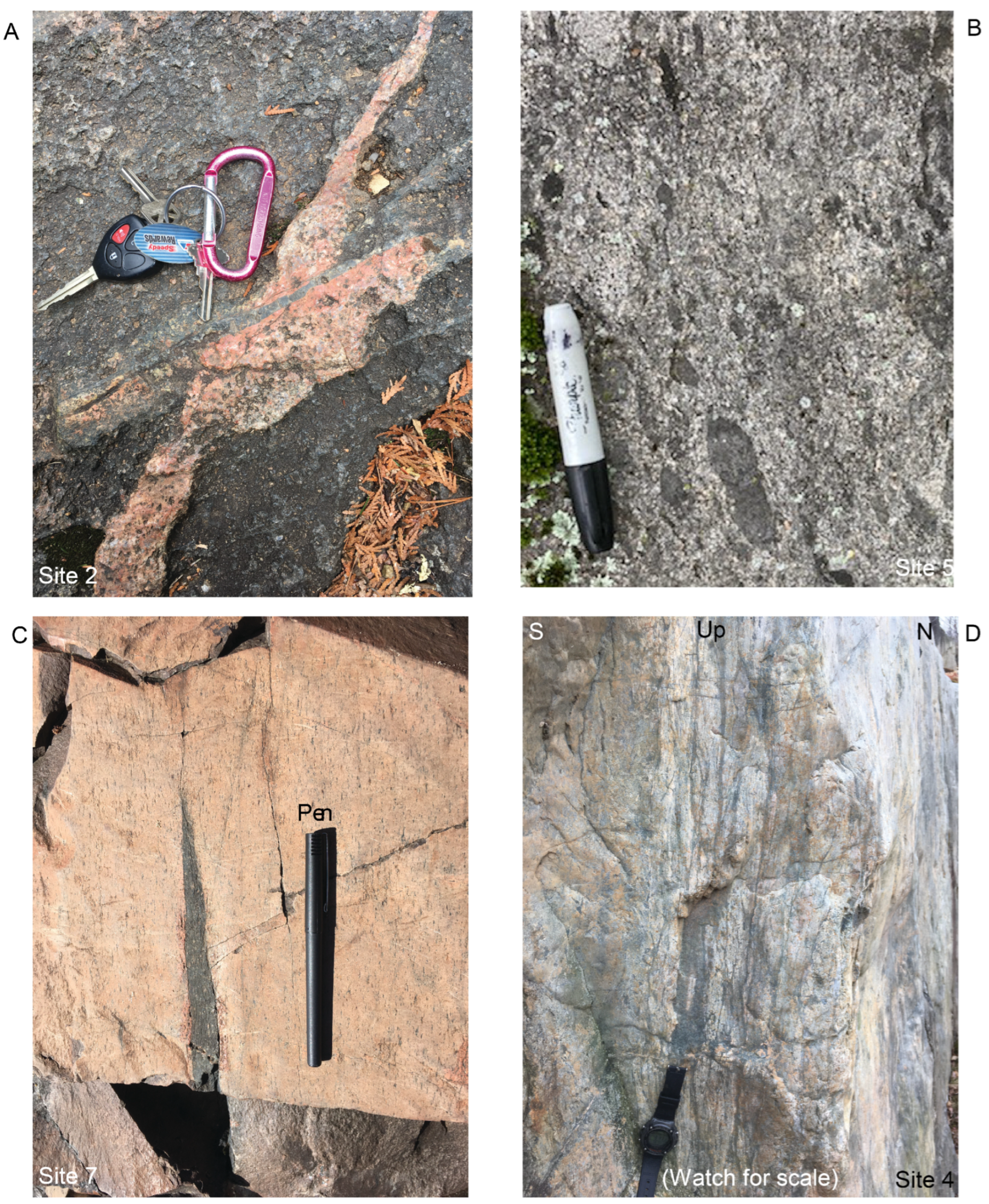
3.1.2. The McCauley Gneiss (Site 6)
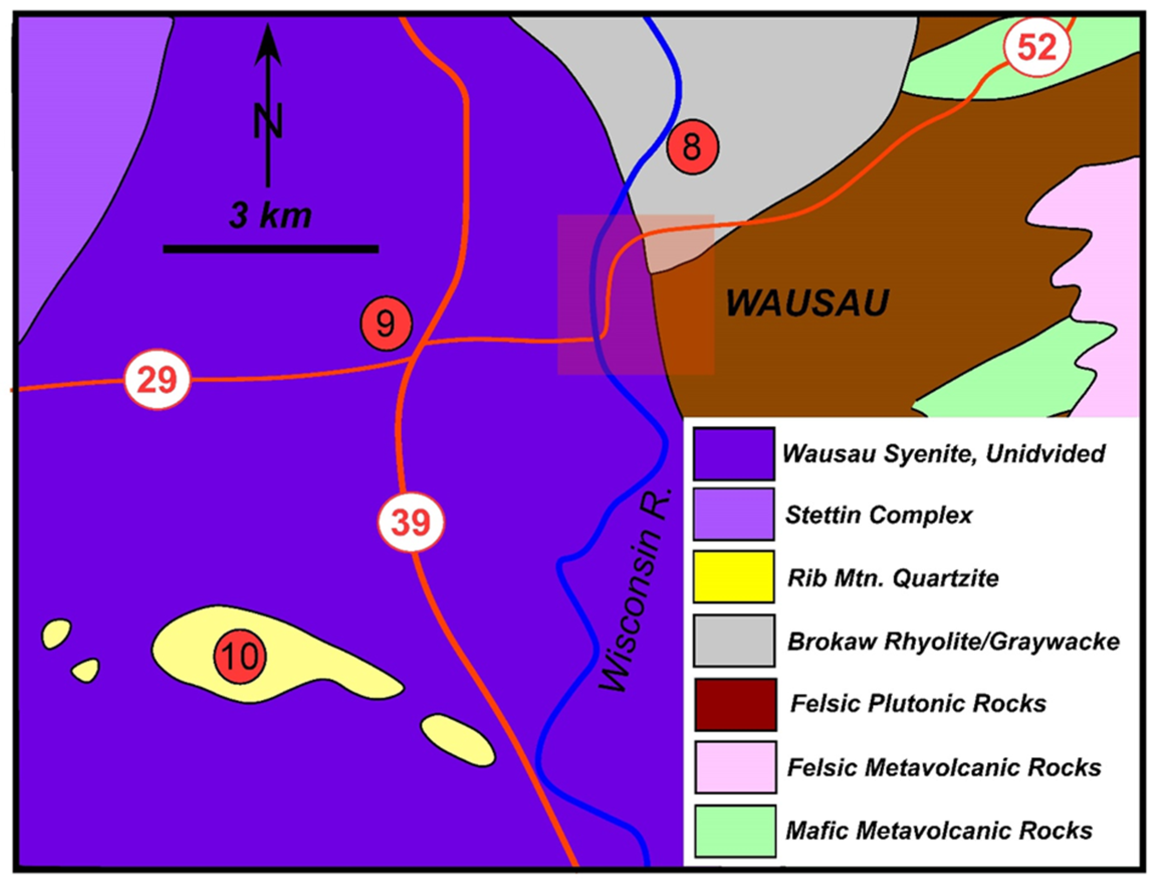
3.1.3. Rib Mountain (Site 10)
3.1.4. Brokaw Metasedimentary and Metavolcanic Rocks (Site 8)
3.1.5. Baldwin Conglomerate (Site 5)
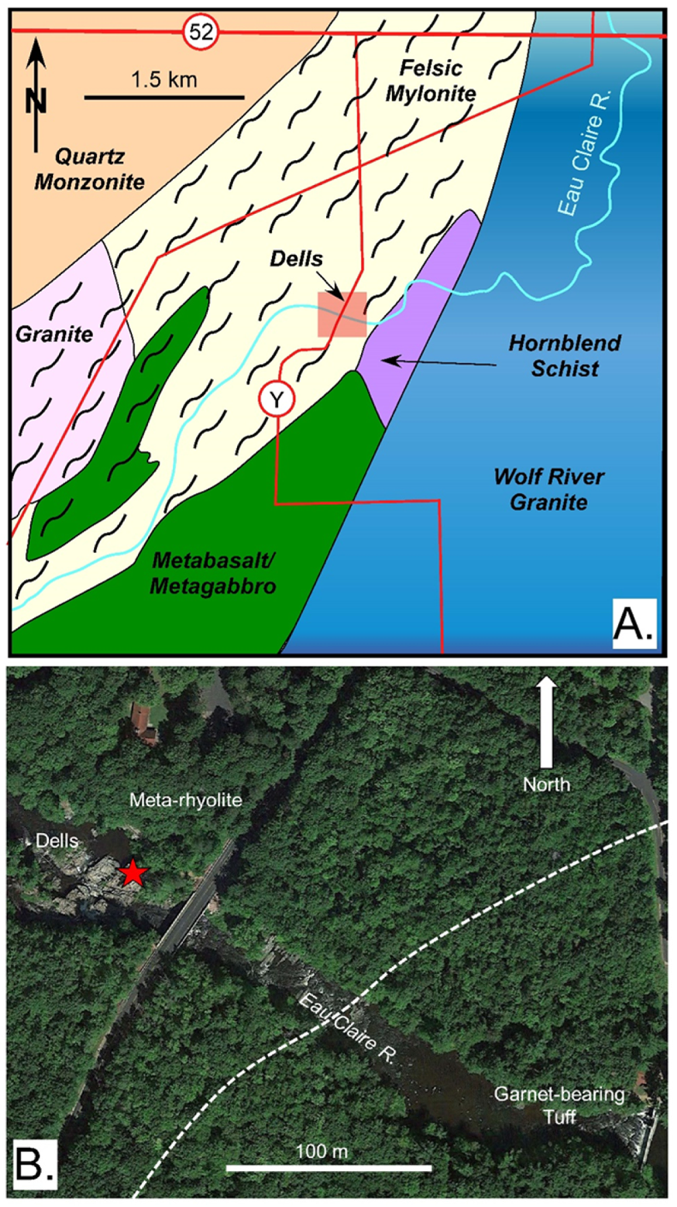
3.1.6. Dells of the Eau Claire River (Site 7)
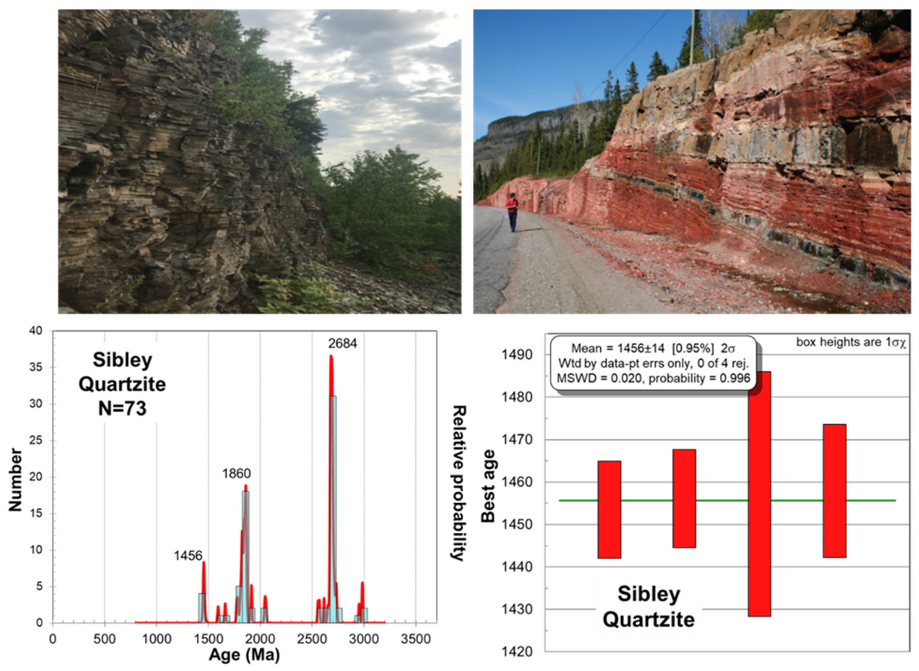
3.1.7. Sibley Group
3.2. Geophysical Investigation
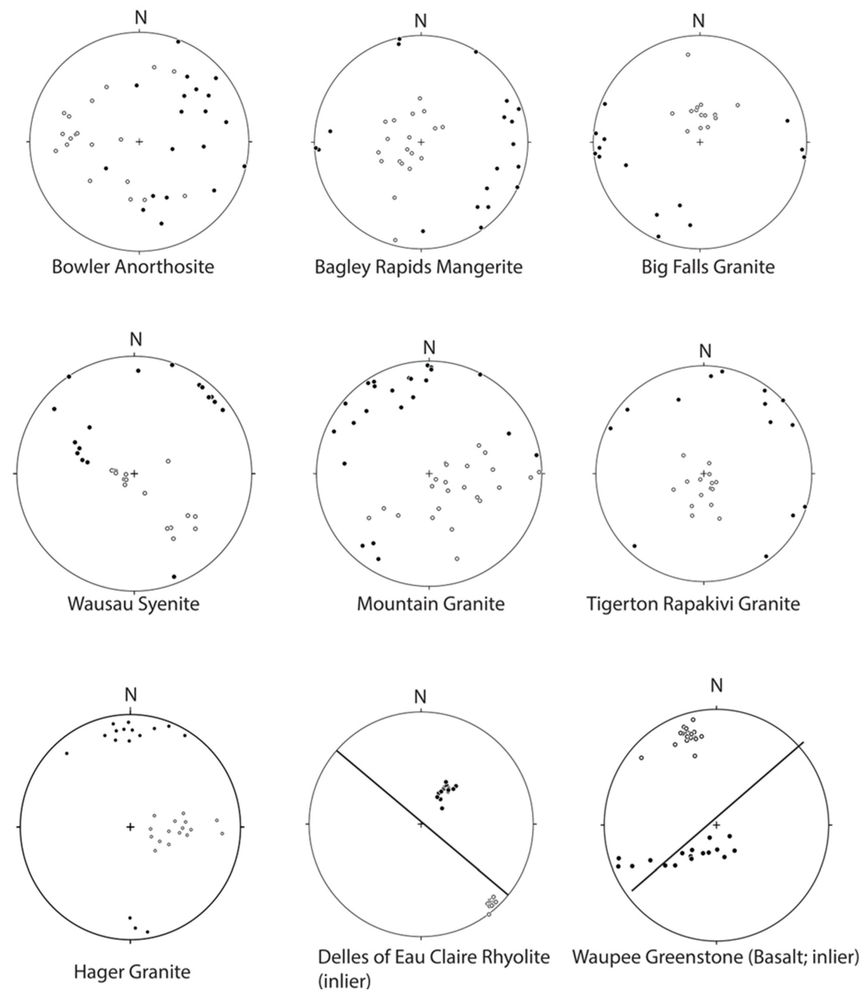
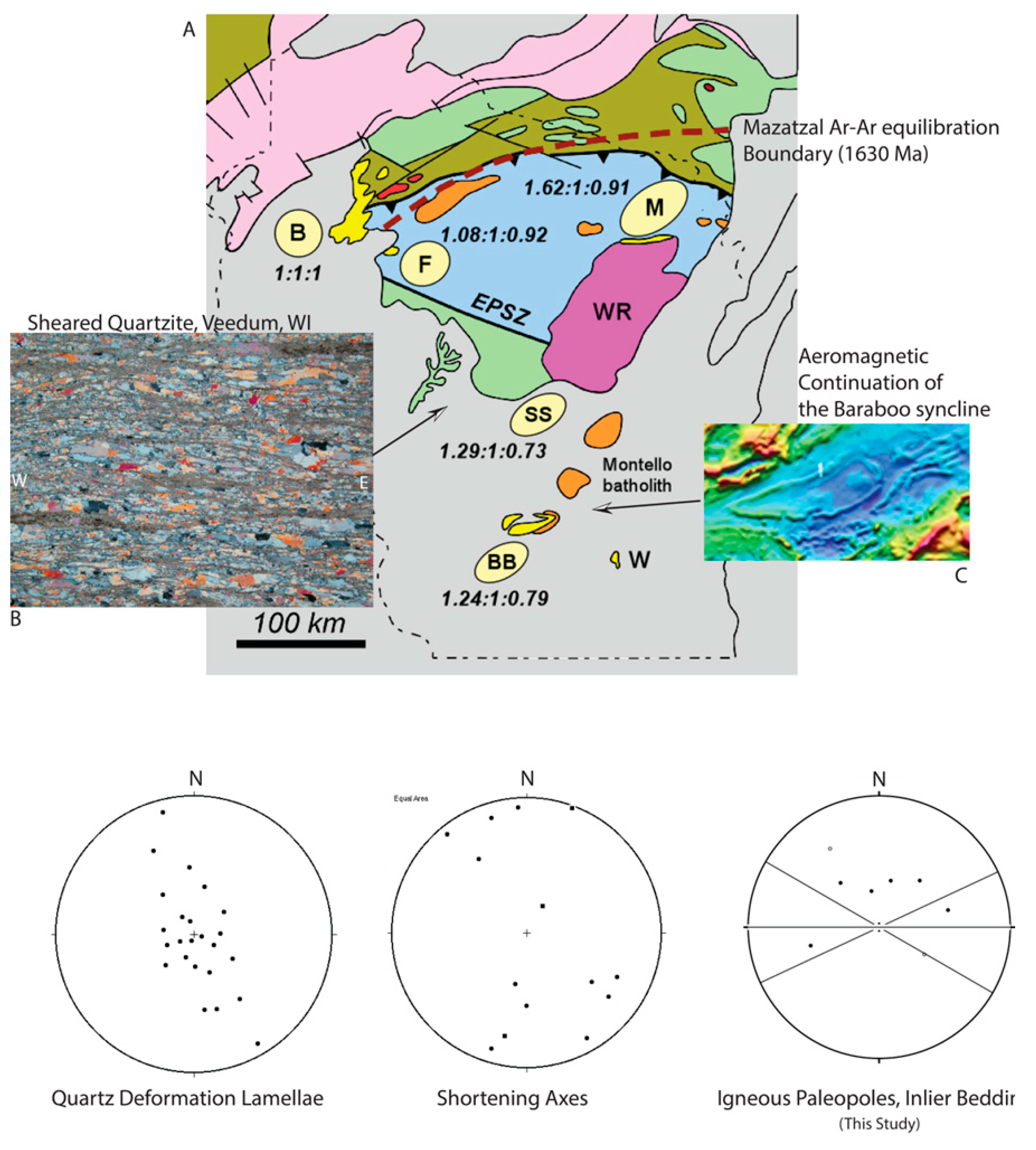
3.2.1. Magnetic Fabrics
3.2.2. Paleomagnetism
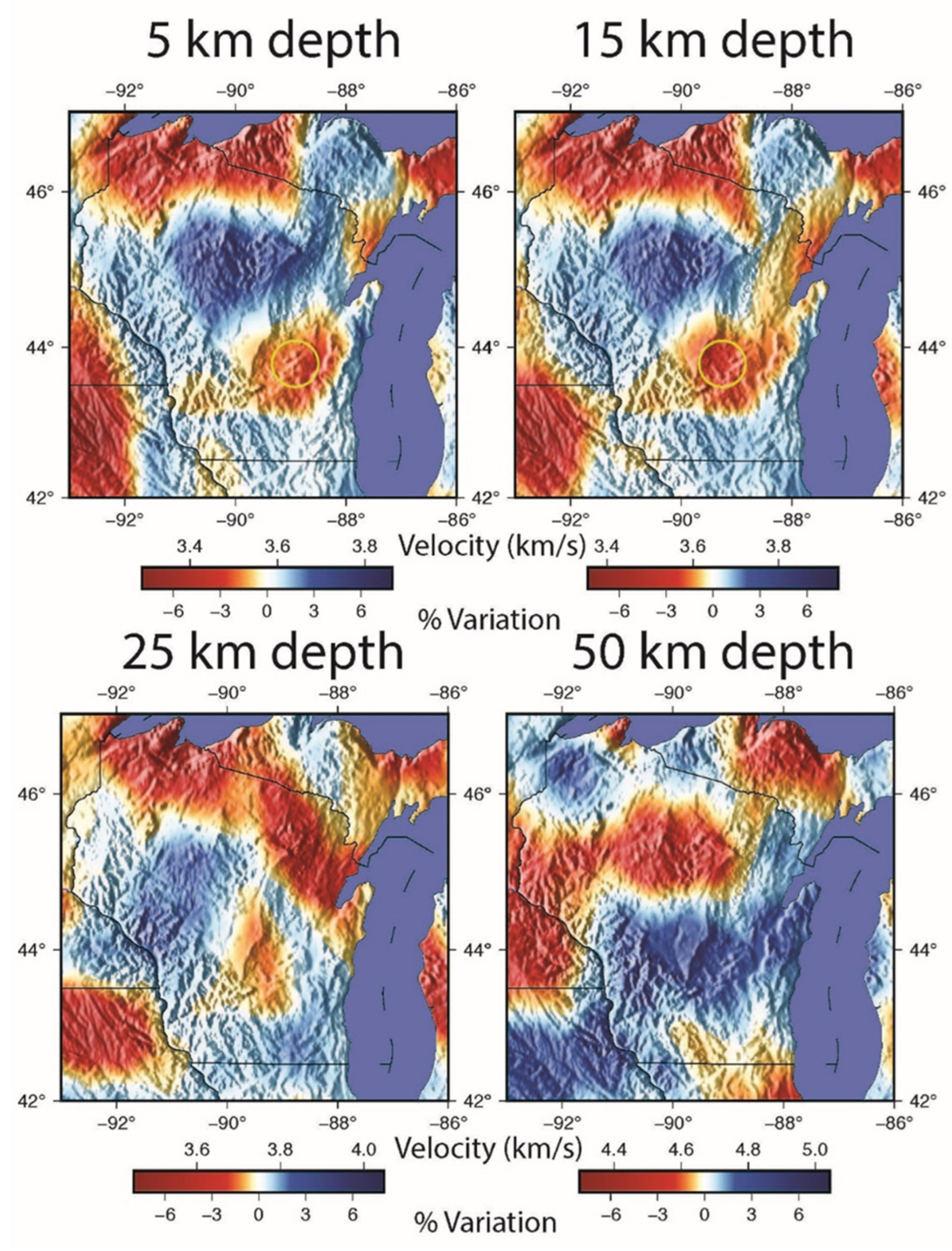
3.2.3. Seismic Profiles
3.2.4. The Mountain Shear Zone
4. Discussion
4.1. Structural Overview
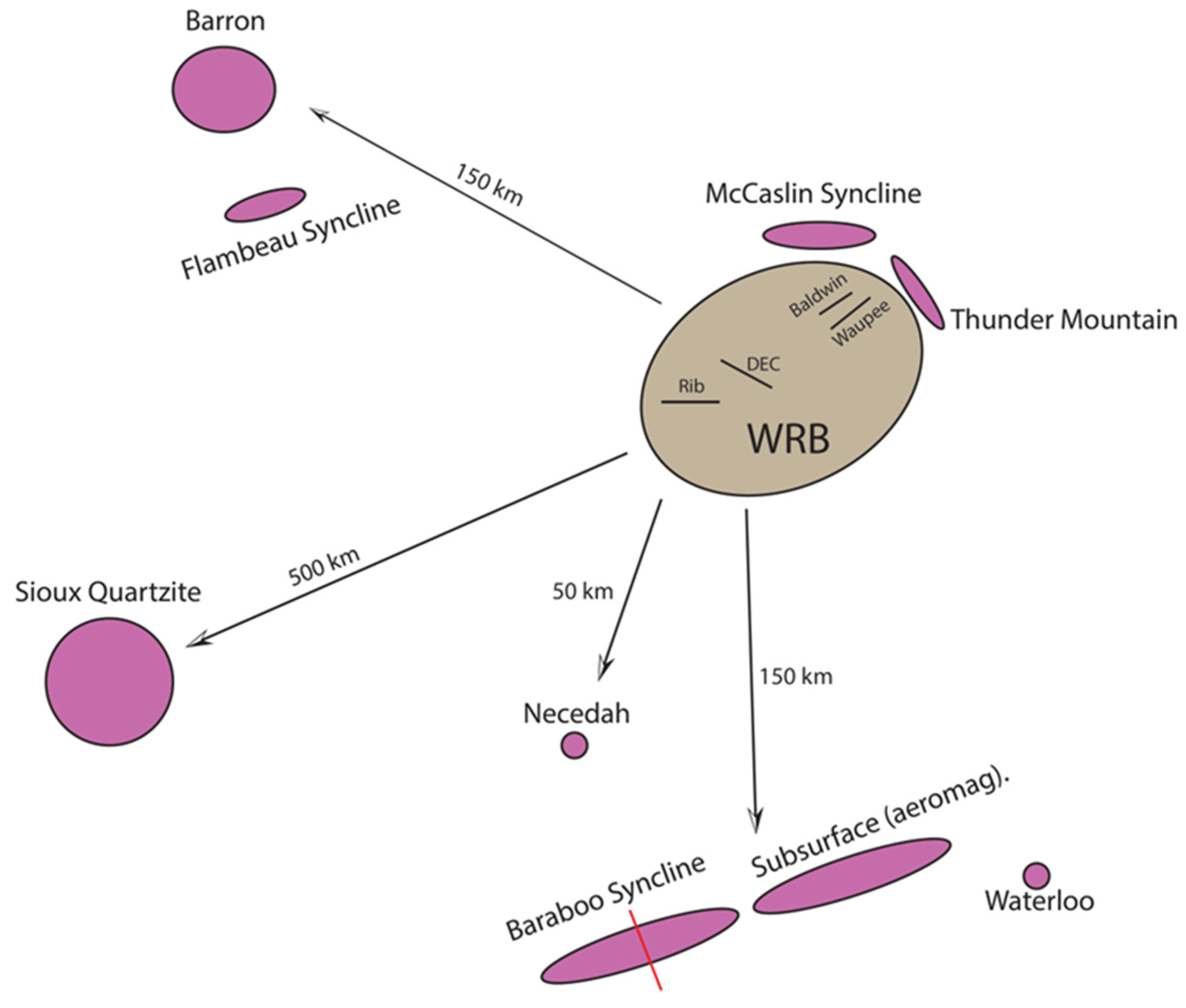
4.2. Synorogenic Sedimentation and Inliers
4.3. Emplacement and Deformation Paleomagnetism
4.4. Palinspastic Restoration
4.5. Regional Tectonics
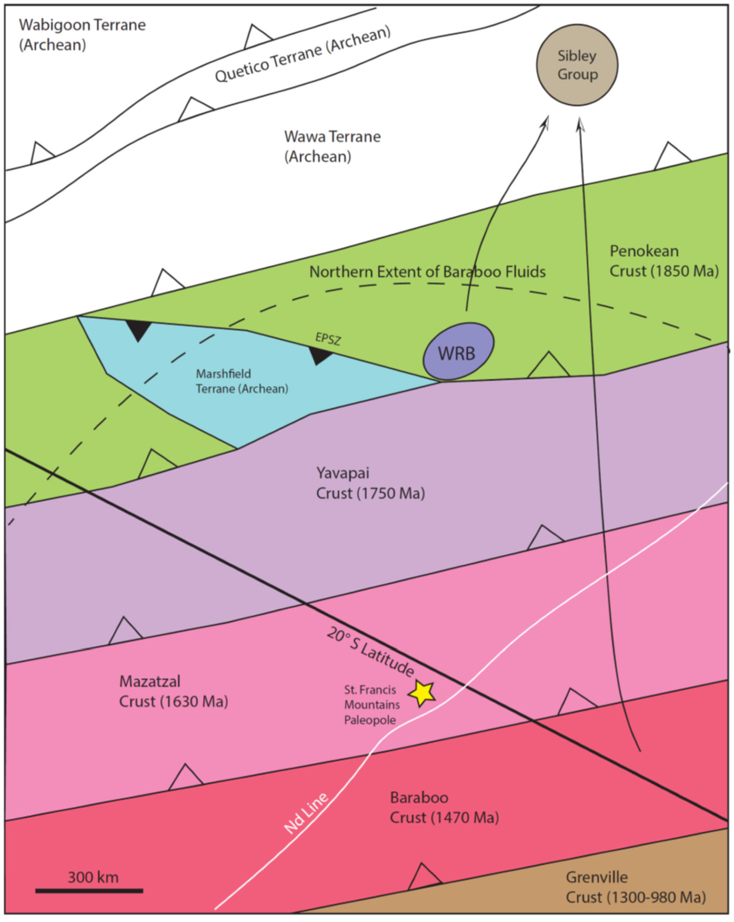
5. Conclusions
Author Contributions
Funding
Data Availability Statement
Acknowledgments
Conflicts of Interest
Abbreviations
| WRB | Wolf River Batholith |
| AMS | Anisotropy of Magnetic Susceptibility |
| U-Pb | Uranium–Lead |
| SEM | Scanning Electron Microscope |
| RF | Receiver Function |
| AF | Alternating Field |
| AC | Alternating Current |
| Ma | Megaannus (one million years) |
| MDA | Maximum Depositional Age |
| km | Kilometers |
| m | Meters |
| cm | Centimeter |
| mm | Millimeter |
| n | Number |
| Nd | Neodymium |
| APWP | Apparent Polar Wander Path |
| nT | NanoTesla |
| mT | MilliTesla |
| Hz | Hertz |
| LA-ICPMS | Laser Ablation Inductively Coupled Plasma Mass Spectrometry |
| Kmax | Maximum Magnetic Susceptibility Axis |
| Kmin | Minimum Magnetic Susceptibility Axis |
| CCP | Common Conversion Point |
| LNS | Layer-Normal Shortening |
| MSWD | Mean Squared Weighted Deviation |
Appendix A
| Sample | Latitude | Longitude | Comment |
|---|---|---|---|
| Wausau Syenite (Site 9) | 44°56′40.66″ N | 89°48′48.97″ W | Highway 29, west of Wausau |
| Bowler Anorthosite (Site 11) | 44°49′19.16″ N | 88°59′42.62″ W | County J, south of Bowler, WI |
| Tigerton Rapakivi Granite (Site 13) | 44°44′45.51″ N | 89°03′37.45″ W | Highway 45, Tigerton, WI |
| Mountain Granite (Site 3) | 45°10′17.42″ N | 88°27′50.74″ W | Highway 32–64, south of Mountain, WI |
| Big Falls Granite (Site 14) | 44°38′00.90″ N | 89°01′18.08″ W | County E and Mud Lake Rd. |
| Keshena Falls Granite (Site 12) | 44°53′08.05″ N | 88°37′42.62″ W | County 55 and the Wolf River |
| Bagley Rapids Mangerite (Site 2) | 45°09′24.68″ N | 88°28′08.45″ W | Bagley Rapids Campground |
| Hager Granite (Site 1) | 45°12′09.00″ N | 88°24′43.25″ W | County W |
| Rib Mountain Quartzite (Site 10) | 44°55′15.24″ N | 89°41′33.62″ W | Rib Mountain Park |
| Wausau Turbidite (Site 8) | 45°00′51.79″ N | 89°37′15.79″ W | County W, North of Wausau |
| Delles of Eau Claire Rhyolite (Site 7) | 45°00′16.86″ N | 89°20′18.33″ W | DEC County Park, off County Y |
| Waupee Greenstone (Site 4) | 45°11′50.49″ N | 88°25′02.98″ W | County W |
| Baldwin Conglomerate (Site 5) | 45°12′02.88″ N | 88°24′43.37″ W | County W |
| McCauley Gneiss (Site 6) | 45°12′21.41″ N | 88°23′45.56″ W | County W |
| Eau Pleine Shear Zone (Sites 15, 16) | 44°42′35.49″ N | 89°41′56.51″ W | County 34, north of Dancy, WI; Railroad cut west of Meyer’s Landing Restaurant before Lake Wisconsin. |
| 44°40′29.64″ N | 89°41′22.40″ W | DuBay Park & Boat Landing |
Appendix B
Appendix B.1
| Isotope Ratios | Apparent Ages (Ma) | ||||||||||||||||||
|---|---|---|---|---|---|---|---|---|---|---|---|---|---|---|---|---|---|---|---|
| Analysis | U | 206 Pb | U/Th | 206 Pb | ± | 207 Pb | ± | 206 Pb | ± | Error | 206 Pb | ± | 207 Pb | ± | 206 Pb | ± | Best Age | ± | Conc |
| (ppm) | 204 Pb | 207 Pb | (%) | 235 U | (%) | 238 U | (%) | Corr. | 238 U | (Ma) | 235 U | (Ma) | 207 Pb | (Ma) | (Ma) | (Ma) | (%) | ||
| Spot 5 | 157 | 83,140 | 1.8 | 10.9436 | 0.6 | 3.2032 | 0.9 | 0.2543 | 0.6 | 0.73 | 1460.9 | 8.4 | 1457.9 | 6.8 | 1453.6 | 11.3 | 1453.6 | 11.3 | 100.5 |
| Spot 31 | 240 | 181,292 | 1.7 | 10.9287 | 0.6 | 3.1859 | 1.1 | 0.2526 | 0.9 | 0.84 | 1452.1 | 12.1 | 1453.8 | 8.6 | 1456.2 | 11.4 | 1456.2 | 11.4 | 99.7 |
| Spot 18 | 101 | 142,605 | 1.1 | 10.9225 | 1.5 | 2.8917 | 2.0 | 0.2292 | 1.4 | 0.67 | 1330.2 | 16.4 | 1379.8 | 15.3 | 1457.3 | 28.5 | 1457.3 | 28.5 | 91.3 |
| Spot 37 | 147 | 167,351 | 2.5 | 10.9184 | 0.8 | 3.2316 | 1.3 | 0.2560 | 1.0 | 0.78 | 1469.4 | 13.4 | 1464.8 | 10.1 | 1458.0 | 15.5 | 1458.0 | 15.5 | 100.8 |
| Spot 53 | 131 | 79,095 | 1.4 | 10.1592 | 0.7 | 3.7355 | 1.4 | 0.2754 | 1.2 | 0.86 | 1567.9 | 17.2 | 1579.0 | 11.5 | 1593.8 | 13.8 | 1593.8 | 13.8 | 98.4 |
| Spot 75 | 148 | 57,465 | 1.5 | 9.7966 | 0.6 | 4.1171 | 1.1 | 0.2927 | 0.9 | 0.82 | 1654.8 | 13.3 | 1657.7 | 9.1 | 1661.4 | 11.7 | 1661.4 | 11.7 | 99.6 |
| Spot 3 | 88 | 44,878 | 1.7 | 9.2133 | 0.7 | 4.8300 | 1.1 | 0.3229 | 0.9 | 0.80 | 1803.8 | 14.2 | 1790.1 | 9.5 | 1774.2 | 12.4 | 1774.2 | 12.4 | 101.7 |
| Spot 38 | 457 | 88,631 | 2.2 | 9.1612 | 0.7 | 4.3127 | 1.2 | 0.2867 | 0.9 | 0.78 | 1624.9 | 13.0 | 1695.8 | 9.6 | 1784.6 | 13.2 | 1784.6 | 13.2 | 91.1 |
| Spot 19 | 217 | 153,098 | 2.5 | 9.0495 | 0.7 | 4.9652 | 1.2 | 0.3260 | 1.0 | 0.84 | 1819.1 | 16.2 | 1813.4 | 10.3 | 1806.9 | 12.2 | 1806.9 | 12.2 | 100.7 |
| Spot 42 | 76 | 196,226 | 2.0 | 9.0106 | 0.8 | 5.2376 | 1.2 | 0.3424 | 0.9 | 0.76 | 1898.4 | 14.7 | 1858.8 | 10.1 | 1814.7 | 14.0 | 1814.7 | 14.0 | 104.6 |
| Spot 39 | 378 | 2,513,254 | 3.3 | 8.9876 | 0.7 | 4.5120 | 1.3 | 0.2942 | 1.1 | 0.85 | 1662.7 | 15.9 | 1733.2 | 10.7 | 1819.4 | 12.4 | 1819.4 | 12.4 | 91.4 |
| Spot 40 | 269 | 77,067 | 3.6 | 8.9549 | 0.6 | 5.2278 | 1.2 | 0.3397 | 1.0 | 0.85 | 1885.1 | 16.8 | 1857.2 | 10.4 | 1826.0 | 11.8 | 1826.0 | 11.8 | 103.2 |
| Spot 8 | 193 | 119,389 | 3.5 | 8.9490 | 0.7 | 5.0993 | 1.1 | 0.3311 | 0.8 | 0.78 | 1843.8 | 13.6 | 1836.0 | 9.3 | 1827.2 | 12.5 | 1827.2 | 12.5 | 100.9 |
| Spot 60 | 340 | 439,841 | 1.9 | 8.9465 | 0.7 | 4.8663 | 1.2 | 0.3159 | 0.9 | 0.81 | 1769.7 | 14.6 | 1796.4 | 9.8 | 1827.7 | 12.2 | 1827.7 | 12.2 | 96.8 |
| Spot 12 | 139 | 151,645 | 3.8 | 8.9399 | 0.8 | 5.0463 | 1.3 | 0.3273 | 1.0 | 0.79 | 1825.5 | 16.3 | 1827.1 | 11.0 | 1829.0 | 14.3 | 1829.0 | 14.3 | 99.8 |
| Spot 70 | 44 | 51,550 | 4.0 | 8.9012 | 0.9 | 5.1896 | 1.5 | 0.3352 | 1.2 | 0.77 | 1863.4 | 18.7 | 1850.9 | 12.7 | 1836.9 | 17.0 | 1836.9 | 17.0 | 101.4 |
| Spot 24 | 164 | 76,951 | 2.8 | 8.8648 | 0.8 | 5.2827 | 1.3 | 0.3398 | 1.1 | 0.80 | 1885.7 | 17.4 | 1866.1 | 11.3 | 1844.3 | 14.4 | 1844.3 | 14.4 | 102.2 |
| Spot 68 | 388 | 188,705 | 2.9 | 8.8640 | 0.6 | 5.1334 | 1.2 | 0.3302 | 1.0 | 0.87 | 1839.2 | 16.4 | 1841.7 | 10.0 | 1844.5 | 10.4 | 1844.5 | 10.4 | 99.7 |
| Spot 7 | 358 | 122,705 | 3.0 | 8.8635 | 0.6 | 5.2169 | 1.2 | 0.3355 | 1.1 | 0.89 | 1865.0 | 17.4 | 1855.4 | 10.3 | 1844.6 | 10.1 | 1844.6 | 10.1 | 101.1 |
| Spot 71 | 313 | 150,320 | 2.7 | 8.8605 | 0.8 | 5.2444 | 1.4 | 0.3372 | 1.1 | 0.80 | 1873.0 | 18.1 | 1859.9 | 11.9 | 1845.2 | 15.1 | 1845.2 | 15.1 | 101.5 |
| Spot 17 | 125 | 270,992 | 4.4 | 8.8156 | 0.8 | 5.2446 | 1.6 | 0.3355 | 1.4 | 0.87 | 1864.8 | 22.7 | 1859.9 | 13.7 | 1854.4 | 14.1 | 1854.4 | 14.1 | 100.6 |
| Spot 14 | 268 | 294,486 | 2.6 | 8.8097 | 0.7 | 5.2502 | 1.4 | 0.3356 | 1.2 | 0.85 | 1865.5 | 18.8 | 1860.8 | 11.7 | 1855.6 | 13.1 | 1855.6 | 13.1 | 100.5 |
| Spot 2 | 223 | 132,474 | 3.4 | 8.8039 | 0.6 | 5.1854 | 1.2 | 0.3312 | 1.0 | 0.85 | 1844.4 | 16.7 | 1850.2 | 10.4 | 1856.8 | 11.5 | 1856.8 | 11.5 | 99.3 |
| Spot 56 | 191 | 89,217 | 3.2 | 8.7951 | 0.7 | 5.0939 | 1.1 | 0.3251 | 0.8 | 0.78 | 1814.4 | 13.1 | 1835.1 | 9.1 | 1858.6 | 12.2 | 1858.6 | 12.2 | 97.6 |
| Spot 67 | 246 | 130,216 | 2.2 | 8.7846 | 0.8 | 5.2636 | 1.3 | 0.3355 | 1.0 | 0.80 | 1865.0 | 16.5 | 1863.0 | 10.8 | 1860.7 | 13.6 | 1860.7 | 13.6 | 100.2 |
| Spot 33 | 241 | 774,039 | 4.2 | 8.7802 | 0.7 | 5.2271 | 1.2 | 0.3330 | 1.0 | 0.83 | 1852.9 | 15.8 | 1857.0 | 10.1 | 1861.6 | 11.9 | 1861.6 | 11.9 | 99.5 |
| Spot 51 | 149 | 262,086 | 2.4 | 8.7724 | 0.6 | 5.2356 | 1.2 | 0.3332 | 1.0 | 0.85 | 1854.1 | 16.0 | 1858.4 | 9.9 | 1863.2 | 11.0 | 1863.2 | 11.0 | 99.5 |
| Spot 6 | 391 | 44,287 | 3.1 | 8.7638 | 0.7 | 5.0223 | 1.5 | 0.3194 | 1.3 | 0.89 | 1786.6 | 20.3 | 1823.1 | 12.4 | 1865.0 | 12.1 | 1865.0 | 12.1 | 95.8 |
| Spot 27 | 95 | 94,432 | 2.3 | 8.7463 | 0.7 | 5.5123 | 1.3 | 0.3498 | 1.1 | 0.85 | 1933.7 | 17.9 | 1902.5 | 10.8 | 1868.6 | 11.8 | 1868.6 | 11.8 | 103.5 |
| Spot 47 | 392 | 176,730 | 2.6 | 8.5353 | 0.8 | 5.3182 | 1.7 | 0.3294 | 1.5 | 0.89 | 1835.3 | 24.2 | 1871.8 | 14.5 | 1912.6 | 13.9 | 1912.6 | 13.9 | 96.0 |
| Spot 52 | 261 | 51,557 | 3.0 | 8.5207 | 0.6 | 5.5134 | 1.1 | 0.3409 | 1.0 | 0.86 | 1890.8 | 15.7 | 1902.7 | 9.6 | 1915.6 | 10.1 | 1915.6 | 10.1 | 98.7 |
| Spot 54 | 182 | 426,062 | 2.0 | 7.9309 | 0.6 | 6.1586 | 1.0 | 0.3544 | 0.8 | 0.76 | 1955.6 | 12.7 | 1998.6 | 8.7 | 2043.3 | 11.5 | 2043.3 | 11.5 | 95.7 |
| Spot 34 | 137 | 123,008 | 0.8 | 7.8854 | 0.7 | 5.6955 | 1.3 | 0.3259 | 1.1 | 0.86 | 1818.3 | 17.9 | 1930.7 | 11.4 | 2053.5 | 12.0 | 2053.5 | 12.0 | 88.5 |
| Spot 22 | 210 | 148,250 | 1.0 | 5.8853 | 0.6 | 10.7676 | 1.3 | 0.4598 | 1.1 | 0.87 | 2438.7 | 22.2 | 2503.3 | 11.7 | 2556.1 | 10.5 | 2556.1 | 10.5 | 95.4 |
| Spot 13 | 300 | 174,885 | 2.8 | 5.8375 | 0.6 | 11.2326 | 1.4 | 0.4758 | 1.3 | 0.90 | 2508.8 | 26.7 | 2542.6 | 13.3 | 2569.7 | 10.2 | 2569.7 | 10.2 | 97.6 |
| Spot 61 | 447 | 30,777 | 2.7 | 5.6828 | 0.5 | 11.0695 | 1.2 | 0.4564 | 1.1 | 0.89 | 2423.8 | 21.3 | 2529.0 | 11.1 | 2614.5 | 9.1 | 2614.5 | 9.1 | 92.7 |
| Spot 63 | 133 | 168,921 | 0.5 | 5.5542 | 0.8 | 13.1725 | 1.6 | 0.5309 | 1.4 | 0.88 | 2745.0 | 31.3 | 2692.1 | 15.1 | 2652.6 | 12.8 | 2652.6 | 12.8 | 103.5 |
| Spot 21 | 117 | 98,272 | 2.1 | 5.4963 | 0.7 | 12.9572 | 1.4 | 0.5167 | 1.2 | 0.87 | 2685.3 | 27.1 | 2676.5 | 13.4 | 2669.9 | 11.6 | 2669.9 | 11.6 | 100.6 |
| Spot 32 | 99 | 1,605,501 | 1.0 | 5.4946 | 0.7 | 13.3976 | 1.3 | 0.5341 | 1.0 | 0.83 | 2758.8 | 23.5 | 2708.1 | 11.9 | 2670.4 | 11.5 | 2670.4 | 11.5 | 103.3 |
| Spot 69 | 268 | 158,972 | 2.4 | 5.4828 | 0.6 | 12.9449 | 1.3 | 0.5150 | 1.1 | 0.88 | 2677.8 | 24.6 | 2675.6 | 12.0 | 2674.0 | 9.9 | 2674.0 | 9.9 | 100.1 |
| Spot 44 | 230 | 309,038 | 1.5 | 5.4740 | 0.7 | 13.1552 | 1.3 | 0.5225 | 1.2 | 0.86 | 2709.8 | 25.6 | 2690.8 | 12.7 | 2676.6 | 11.3 | 2676.6 | 11.3 | 101.2 |
| Spot 35 | 159 | 409,279 | 1.3 | 5.4722 | 0.6 | 13.2505 | 1.2 | 0.5261 | 1.0 | 0.86 | 2725.1 | 22.9 | 2697.7 | 11.3 | 2677.2 | 10.1 | 2677.2 | 10.1 | 101.8 |
| Spot 36 | 166 | 174,563 | 1.1 | 5.4721 | 0.5 | 13.3680 | 1.1 | 0.5308 | 1.0 | 0.89 | 2744.7 | 22.5 | 2706.0 | 10.7 | 2677.2 | 8.7 | 2677.2 | 8.7 | 102.5 |
| Spot 74 | 180 | 137,451 | 2.2 | 5.4718 | 0.5 | 13.2409 | 1.0 | 0.5257 | 0.8 | 0.85 | 2723.3 | 18.4 | 2697.0 | 9.3 | 2677.3 | 8.6 | 2677.3 | 8.6 | 101.7 |
| Spot 49 | 264 | 145,377 | 0.6 | 5.4688 | 0.6 | 13.2135 | 1.1 | 0.5243 | 1.0 | 0.84 | 2717.5 | 21.2 | 2695.0 | 10.7 | 2678.2 | 10.1 | 2678.2 | 10.1 | 101.5 |
| Spot 64 | 69 | 32,480 | 1.9 | 5.4640 | 0.7 | 13.3371 | 1.2 | 0.5288 | 1.0 | 0.82 | 2736.2 | 22.5 | 2703.8 | 11.6 | 2679.7 | 11.7 | 2679.7 | 11.7 | 102.1 |
| Spot 23 | 231 | 122,598 | 1.2 | 5.4572 | 0.7 | 13.4185 | 1.3 | 0.5313 | 1.1 | 0.84 | 2747.0 | 23.9 | 2709.6 | 12.1 | 2681.7 | 11.6 | 2681.7 | 11.6 | 102.4 |
| Spot 26 | 178 | 1,029,122 | 2.0 | 5.4542 | 0.8 | 12.9982 | 1.3 | 0.5144 | 1.1 | 0.82 | 2675.4 | 24.1 | 2679.5 | 12.7 | 2682.6 | 12.8 | 2682.6 | 12.8 | 99.7 |
| Spot 45 | 131 | 253,962 | 1.3 | 5.4537 | 0.6 | 13.5684 | 1.2 | 0.5369 | 1.0 | 0.86 | 2770.6 | 23.4 | 2720.1 | 11.4 | 2682.8 | 10.1 | 2682.8 | 10.1 | 103.3 |
| Spot 48 | 227 | 94,652 | 1.5 | 5.4516 | 0.7 | 13.3170 | 1.4 | 0.5268 | 1.2 | 0.87 | 2727.8 | 27.2 | 2702.4 | 13.2 | 2683.4 | 11.3 | 2683.4 | 11.3 | 101.7 |
| Spot 58 | 99 | 382,223 | 1.2 | 5.4463 | 0.6 | 12.5047 | 1.1 | 0.4942 | 1.0 | 0.85 | 2588.6 | 20.3 | 2643.1 | 10.5 | 2685.0 | 9.7 | 2685.0 | 9.7 | 96.4 |
| Spot 20 | 259 | 458,076 | 1.2 | 5.4448 | 0.7 | 13.0687 | 1.4 | 0.5163 | 1.2 | 0.87 | 2683.4 | 27.1 | 2684.6 | 13.4 | 2685.5 | 11.6 | 2685.5 | 11.6 | 99.9 |
| Spot 41 | 170 | 115,574 | 0.9 | 5.4409 | 0.7 | 13.3650 | 1.2 | 0.5276 | 1.0 | 0.82 | 2731.5 | 22.1 | 2705.8 | 11.5 | 2686.7 | 11.6 | 2686.7 | 11.6 | 101.7 |
| Spot 4 | 194 | 1,089,403 | 1.5 | 5.4375 | 0.6 | 13.3320 | 1.1 | 0.5260 | 0.9 | 0.86 | 2724.6 | 21.0 | 2703.4 | 10.4 | 2687.7 | 9.4 | 2687.7 | 9.4 | 101.4 |
| Spot 30 | 191 | 659,487 | 1.3 | 5.4312 | 0.6 | 12.7241 | 1.2 | 0.5014 | 1.1 | 0.86 | 2620.0 | 23.2 | 2659.4 | 11.7 | 2689.6 | 10.4 | 2689.6 | 10.4 | 97.4 |
| Spot 37 | 314 | 152,417 | 1.3 | 5.4312 | 0.6 | 13.3453 | 1.2 | 0.5259 | 1.1 | 0.88 | 2724.2 | 24.1 | 2704.4 | 11.6 | 2689.6 | 9.4 | 2689.6 | 9.4 | 101.3 |
| Spot 29 | 199 | 233,245 | 1.0 | 5.4251 | 0.6 | 13.3504 | 1.2 | 0.5255 | 1.0 | 0.87 | 2722.5 | 22.7 | 2704.8 | 11.1 | 2691.5 | 9.7 | 2691.5 | 9.7 | 101.2 |
| Spot 73 | 421 | 22,999,805 | 1.6 | 5.4189 | 0.6 | 13.3477 | 0.9 | 0.5248 | 0.7 | 0.75 | 2719.6 | 14.4 | 2704.6 | 8.2 | 2693.4 | 9.6 | 2693.4 | 9.6 | 101.0 |
| Spot 16 | 73 | 130,632 | 1.5 | 5.4166 | 0.7 | 13.1081 | 1.3 | 0.5152 | 1.0 | 0.83 | 2678.7 | 22.9 | 2687.5 | 11.9 | 2694.0 | 11.8 | 2694.0 | 11.8 | 99.4 |
| Spot 43 | 243 | 544,508 | 2.0 | 5.4115 | 0.7 | 13.1008 | 1.3 | 0.5144 | 1.1 | 0.85 | 2675.4 | 24.6 | 2686.9 | 12.5 | 2695.6 | 11.6 | 2695.6 | 11.6 | 99.3 |
| Spot 57 | 186 | 304,203 | 0.9 | 5.4113 | 0.6 | 13.3284 | 1.1 | 0.5233 | 0.9 | 0.86 | 2713.3 | 20.4 | 2703.2 | 10.2 | 2695.7 | 9.1 | 2695.7 | 9.1 | 100.7 |
| Spot 10 | 169 | 1,147,427 | 1.3 | 5.4092 | 0.6 | 13.3291 | 1.1 | 0.5231 | 1.0 | 0.84 | 2712.5 | 21.0 | 2703.2 | 10.7 | 2696.3 | 10.2 | 2696.3 | 10.2 | 100.6 |
| Spot 65 | 253 | 3,487,695 | 1.3 | 5.4014 | 0.7 | 13.5064 | 1.1 | 0.5293 | 0.9 | 0.79 | 2738.7 | 20.1 | 2715.7 | 10.8 | 2698.7 | 11.6 | 2698.7 | 11.6 | 101.5 |
| Spot 15 | 456 | 1,975,270 | 1.2 | 5.4002 | 0.7 | 13.2635 | 1.4 | 0.5197 | 1.3 | 0.89 | 2697.9 | 28.1 | 2698.6 | 13.5 | 2699.1 | 10.9 | 2699.1 | 10.9 | 100.0 |
| Spot 50 | 148 | 81,732 | 1.1 | 5.3940 | 0.6 | 13.2234 | 1.4 | 0.5175 | 1.2 | 0.89 | 2688.7 | 26.9 | 2695.7 | 12.9 | 2701.0 | 10.2 | 2701.0 | 10.2 | 99.5 |
| Spot 25 | 264 | 124,822 | 0.8 | 5.3805 | 0.7 | 13.0758 | 1.1 | 0.5105 | 0.9 | 0.80 | 2658.7 | 19.9 | 2685.1 | 10.8 | 2705.1 | 11.4 | 2705.1 | 11.4 | 98.3 |
| Spot 46 | 213 | 603,884 | 2.0 | 5.3596 | 0.5 | 13.6319 | 1.0 | 0.5301 | 0.9 | 0.86 | 2742.0 | 20.1 | 2724.5 | 9.9 | 2711.5 | 8.9 | 2711.5 | 8.9 | 101.1 |
| Spot 66 | 311 | 752,893 | 1.1 | 5.3332 | 0.6 | 13.6725 | 1.2 | 0.5291 | 1.0 | 0.84 | 2737.6 | 22.3 | 2727.3 | 11.2 | 2719.7 | 10.6 | 2719.7 | 10.6 | 100.7 |
| Spot 11 | 135 | 638,834 | 2.3 | 5.2983 | 0.6 | 13.4456 | 1.1 | 0.5169 | 1.0 | 0.87 | 2686.0 | 21.5 | 2711.5 | 10.7 | 2730.5 | 9.2 | 2730.5 | 9.2 | 98.4 |
| Spot 72 | 198 | 128,051 | 1.9 | 5.2806 | 0.8 | 13.7712 | 1.1 | 0.5276 | 0.8 | 0.72 | 2731.5 | 18.1 | 2734.1 | 10.6 | 2736.0 | 12.8 | 2736.0 | 12.8 | 99.8 |
| Spot 59 | 41 | 78,532 | 1.0 | 4.6250 | 0.7 | 17.8811 | 1.2 | 0.6001 | 0.9 | 0.78 | 3030.1 | 22.1 | 2983.4 | 11.3 | 2952.0 | 11.8 | 2952.0 | 11.8 | 102.6 |
| Spot 62 | 85 | 101,413 | 0.6 | 4.5393 | 0.7 | 18.0093 | 1.3 | 0.5932 | 1.1 | 0.84 | 3002.2 | 26.1 | 2990.2 | 12.4 | 2982.1 | 11.2 | 2982.1 | 11.2 | 100.7 |
| Spot 55 | 39 | 33,174 | 2.7 | 4.5312 | 0.7 | 18.6165 | 1.1 | 0.6121 | 0.9 | 0.79 | 3078.3 | 20.8 | 3022.2 | 10.3 | 2985.0 | 10.5 | 2985.0 | 10.5 | 103.1 |
Appendix B.2
| Isotope Ratios | Apparent Ages (Ma) | ||||||||||||||||||||||||
|---|---|---|---|---|---|---|---|---|---|---|---|---|---|---|---|---|---|---|---|---|---|---|---|---|---|
| Analysis | U | Th | 206 Pb | 208 Pb | U/Th | 206 Pb | ± | 208 Pb | ± | 207 Pb | ± | 206 Pb | ± | Error | 206 Pb | ± | 207 Pb | ± | 206 Pb | ± | 208 Pb | ± | Best Age | ± | Conc |
| (ppm) | (ppm) | 204 Pb | 204 Pb | 207 Pb | (% 2σ) | 232 Th | (% 2σ) | 235 U | (% 2σ) | 238 U | (% 2σ) | Corr. | 238 U | (Ma 2σ) | 235 U | (Ma 2σ) | 207 Pb | (Ma 2σ) | 232 Th | (Ma 2σ) | (Ma) | (Ma) | (%) | ||
| Spot 4 | 636 | 3193 | 5809 | 97,152 | 0.2 | 10.9732 | 13.8 | 0.1 | 40 | 2.974 | 43.7 | 0.2368 | 41.5 | 0.95 | 1370 | 512.4 | 1401 | 335.4 | 1448.5 | 263.6 | 1394 | 538.8 | 1394 | 538.8 | 103.4 |
| Spot 7 | 598 | 3324 | 78,116 | 617,295 | 0.2 | 10.3632 | 20 | 0.1 | 40 | 3.0457 | 46 | 0.229 | 41.4 | 0.9 | 1329.3 | 497.1 | 1419.1 | 354.9 | 1556.6 | 377 | 1468.6 | 566.6 | 1468.6 | 566.6 | 109.7 |
| Spot 5 | 25 | 117 | 13,982 | 20,486 | 0.2 | 11.4115 | 14.5 | 0.1 | 40 | 2.8305 | 61.7 | 0.2344 | 60 | 0.97 | 1357.3 | 735.2 | 1363.6 | 471.5 | 1373.6 | 279.8 | 1489.8 | 574.5 | 1489.8 | 574.5 | 100.7 |
| Spot 1 | 3360 | 5679 | 136,587 | 551,914 | 0.6 | 10.4819 | 1.7 | 0.1 | 40 | 3.1635 | 10.8 | 0.2406 | 10.7 | 0.99 | 1389.8 | 133.9 | 1448.3 | 83.6 | 1535.2 | 31.1 | 1536.3 | 591.8 | 1536.3 | 591.8 | 106 |
| Spot 3 | 1344 | 3729 | 160,444 | 418,395 | 0.4 | 10.5163 | 1.8 | 0.1 | 9.6 | 3.5646 | 4.8 | 0.272 | 4.4 | 0.92 | 1550.9 | 60.9 | 1541.7 | 37.9 | 1529 | 34.3 | 1629.7 | 150.2 | 1629.7 | 150.2 | 99.2 |
| Spot 6 | 88 | 739 | 25,163 | 298,763 | 0.1 | 10.8851 | 13.1 | 0.1 | 40 | 3.6258 | 61.4 | 0.2864 | 60 | 0.98 | 1623.4 | 862.3 | 1555.2 | 498.5 | 1463.8 | 248.8 | 2022.6 | 769.9 | 2022.6 | 769.9 | 94.1 |
| Spot 8 | 84 | 339 | 69,583 | 99,257 | 0.2 | 10.4245 | 3.6 | 0.2 | 33.4 | 5.049 | 15 | 0.3819 | 14.6 | 0.97 | 2085.1 | 259.8 | 1827.6 | 127.4 | 1545.5 | 66.9 | 2869.9 | 895 | 2869.9 | 895 | 84.6 |
| Spot 9 | 0 | 0 | 1000 | 1000 | 75.8 | 3.7642 | 2.1 | 0.7 | 2 | 48.1158 | 2.4 | 1.3142 | 1.2 | 0.5 | 5408.9 | 43.9 | 3954.1 | 23.7 | 3279.9 | 32.3 | 10,303.1 | 161.4 | 10,303.1 | 161.4 | 82.9 |
| Spot 2 | 37 | 103 | 1235 | 4130 | 0.4 | 1.4478 | 0.1 | 0.5 | 5.5 | 54.4218 | 14.7 | 0.5717 | 14.7 | 1 | 2914.9 | 345.9 | 4076.7 | 147.3 | 0 | NA | 8662.3 | 385.6 | 8662.3 | 385.6 | 0 |
| 554 | 105 | 40,068 | 1543 | 73,544 | 0 | 10.1972 | 21.5 | 0 | 2.9 | 0.0614 | 22.1 | 0.0045 | 5.5 | 0.25 | 29.2 | 1.6 | 60.5 | 13 | 1586.8 | 402.3 | 46.7 | 1.4 | 46.7 | 1.4 | 2622.2 |
| 554 | 105 | 42,006 | 2929 | 47,954 | 0 | 5.8254 | 15 | 0 | 3.4 | 0.1148 | 15.9 | 0.0049 | 5.4 | 0.34 | 31.2 | 1.7 | 110.4 | 16.6 | 2573.2 | 250.3 | 48.7 | 1.6 | 48.7 | 1.6 | 2331.6 |
| 554 | 114 | 39,645 | 1401 | 30,428 | 0 | 8.0336 | 13.7 | 0 | 4.1 | 0.0911 | 14.7 | 0.0053 | 5.3 | 0.36 | 34.2 | 1.8 | 88.6 | 12.5 | 2020.6 | 243.6 | 46.7 | 1.9 | 46.7 | 1.9 | 2281.8 |
| 554 | 93 | 32,679 | 2586 | 62,335 | 0 | 7.7009 | 20.5 | 0 | 3.8 | 0.1108 | 21.5 | 0.0062 | 6.4 | 0.3 | 39.8 | 2.5 | 106.7 | 21.8 | 2095.2 | 361.7 | 49 | 1.8 | 49 | 1.8 | 1963.7 |
| 554 | 96 | 38,239 | 2321 | 73,051 | 0 | 3.6523 | 8.3 | 0 | 3.5 | 0.2223 | 11.9 | 0.0059 | 8.5 | 0.72 | 37.9 | 3.2 | 203.8 | 21.9 | 3327.2 | 129.7 | 44 | 1.5 | 44 | 1.5 | 1632.3 |
| 554 | 115 | 38,016 | 1881 | 125,902 | 0 | 6.2062 | 16.9 | 0 | 3.2 | 0.1033 | 18.4 | 0.0047 | 7.2 | 0.39 | 29.9 | 2.2 | 99.8 | 17.5 | 2466.8 | 286.7 | 49.2 | 1.6 | 49.2 | 1.6 | 2471 |
| 554 | 112 | 39,274 | 1397 | 142,131 | 0 | 6.2294 | 15.5 | 0 | 3.9 | 0.091 | 17.5 | 0.0041 | 8.2 | 0.47 | 26.5 | 2.2 | 88.5 | 14.9 | 2460.5 | 261.9 | 47.7 | 1.8 | 47.7 | 1.8 | 2781.5 |
| 554 | 90 | 34,945 | 1383 | 127,317 | 0 | 6.8217 | 25.1 | 0 | 4.3 | 0.1069 | 26.1 | 0.0053 | 7.3 | 0.28 | 34 | 2.5 | 103.1 | 25.6 | 2305.8 | 432.6 | 47.9 | 2.1 | 47.9 | 2.1 | 2235.6 |
| 554 | 106 | 35,893 | 2121 | 13,997 | 0 | 8.8375 | 18.7 | 0 | 3.6 | 0.0739 | 20.1 | 0.0047 | 7.4 | 0.37 | 30.5 | 2.3 | 72.4 | 14.1 | 1849.9 | 339.2 | 47.7 | 1.7 | 47.7 | 1.7 | 2553.8 |
| 554 | 100 | 40,083 | 1688 | 118,923 | 0 | 6.8052 | 16.4 | 0 | 5.3 | 0.0949 | 17.7 | 0.0047 | 6.8 | 0.38 | 30.1 | 2 | 92.1 | 15.6 | 2309.9 | 282 | 46.4 | 2.5 | 46.4 | 2.5 | 2508.6 |
| 554 | 115 | 38,190 | 3461 | 11,912 | 0 | 8.1726 | 26.2 | 0 | 2.7 | 0.089 | 27.6 | 0.0053 | 8.9 | 0.32 | 33.9 | 3 | 86.6 | 22.9 | 1990.1 | 467.4 | 48.3 | 1.3 | 48.3 | 1.3 | 2298.2 |
| 554 | 111 | 38,570 | 1489 | 1329 | 0 | 6.2974 | 14.6 | 0 | 3.8 | 0.1121 | 15.3 | 0.0051 | 4.8 | 0.31 | 32.9 | 1.6 | 107.8 | 15.7 | 2442.1 | 247.1 | 45.9 | 1.7 | 45.9 | 1.7 | 2264.4 |
| 554 | 111 | 40,017 | 1567 | 128,821 | 0 | 8.3221 | 25.7 | 0 | 3.5 | 0.075 | 26.5 | 0.0045 | 6.5 | 0.25 | 29.1 | 1.9 | 73.4 | 18.8 | 1957.8 | 461.3 | 46.7 | 1.6 | 46.7 | 1.6 | 2666.7 |
| 44,069 | 4399 | 40,279 | 127,269 | 615,307 | 0.1 | 17.9116 | 1.6 | 0 | 3.3 | 0.5213 | 2.5 | 0.0677 | 1.8 | 0.75 | 422.6 | 7.5 | 426 | 8.5 | 444.6 | 36.3 | 431.3 | 14.2 | 431.3 | 14.2 | 104.4 |
| 44,069 | 5604 | 36,884 | 168,571 | 832,937 | 0.2 | 17.9813 | 1.3 | 0 | 3.5 | 0.5166 | 2.5 | 0.0674 | 2.2 | 0.86 | 420.5 | 8.8 | 422.9 | 8.7 | 436 | 28.5 | 413 | 14.4 | 413 | 14.4 | 103.1 |
| 44,069 | 3051 | 24,194 | 200,000 | 815,054 | 0.1 | 17.956 | 2.2 | 0 | 4.3 | 0.5425 | 3.3 | 0.0707 | 2.4 | 0.74 | 440.2 | 10.4 | 440.1 | 11.7 | 439.1 | 48.7 | 430.8 | 18.5 | 430.8 | 18.5 | 99.8 |
| 44,069 | 2245 | 30,919 | 80,168 | 367,570 | 0.1 | 17.7073 | 2.2 | 0 | 3.1 | 0.5259 | 2.8 | 0.0676 | 1.7 | 0.62 | 421.5 | 7.1 | 429.1 | 9.8 | 470.1 | 48.5 | 426.2 | 13.1 | 426.2 | 13.1 | 109.6 |
| 44,069 | 2270 | 27,863 | 96,585 | 413,745 | 0.1 | 18.3529 | 1.3 | 0 | 4.3 | 0.5089 | 2.1 | 0.0678 | 1.6 | 0.78 | 422.7 | 6.7 | 417.7 | 7.2 | 390.3 | 29.3 | 448.9 | 19 | 448.9 | 19 | 93.4 |
| 44,069 | 3212 | 32,323 | 4559 | 11,819 | 0.1 | 18.7277 | 2 | 0 | 4.3 | 0.495 | 3.1 | 0.0673 | 2.3 | 0.76 | 419.7 | 9.4 | 408.3 | 10.3 | 344.7 | 45.2 | 421.5 | 18 | 421.5 | 18 | 84.4 |
| 44,069 | 3302 | 38,396 | 96,694 | 413,828 | 0.1 | 18.2363 | 1.4 | 0 | 5.2 | 0.5152 | 2.4 | 0.0682 | 1.9 | 0.81 | 425.1 | 7.9 | 421.9 | 8.2 | 404.5 | 31.3 | 424.2 | 21.9 | 424.2 | 21.9 | 95.9 |
| 44,069 | 2610 | 33,594 | 3109 | 10,451 | 0.1 | 19.5088 | 2 | 0 | 4.9 | 0.4802 | 2.6 | 0.068 | 1.6 | 0.64 | 424 | 6.7 | 398.2 | 8.5 | 251.5 | 45.7 | 428.1 | 20.9 | 428.1 | 20.9 | 63.2 |
| 44,069 | 2637 | 25,737 | 9283 | 23,015 | 0.1 | 18.1521 | 2.3 | 0 | 4.1 | 0.5333 | 2.9 | 0.0702 | 1.7 | 0.6 | 437.6 | 7.3 | 434 | 10.1 | 414.9 | 51 | 439.8 | 17.9 | 439.8 | 17.9 | 95.6 |
| 44,069 | 2676 | 35,177 | 39,310 | 186,539 | 0.1 | 17.8281 | 1.6 | 0 | 3.6 | 0.5166 | 2.1 | 0.0668 | 1.4 | 0.64 | 417 | 5.5 | 422.9 | 7.4 | 455 | 36.2 | 417 | 14.7 | 417 | 14.7 | 107.6 |
| 44,069 | 2665 | 27,258 | 200,000 | 875,765 | 0.1 | 17.9667 | 1.9 | 0 | 2.9 | 0.5314 | 2.6 | 0.0693 | 1.7 | 0.68 | 431.8 | 7.3 | 432.7 | 9.1 | 437.8 | 42.2 | 430.8 | 12.5 | 430.8 | 12.5 | 101.2 |
| 44,069 | 2521 | 28,579 | 36,870 | 176,562 | 0.1 | 17.6527 | 1.8 | 0 | 3.4 | 0.5261 | 2.8 | 0.0674 | 2.2 | 0.76 | 420.4 | 8.8 | 429.2 | 9.9 | 476.9 | 40.8 | 424.6 | 14.2 | 424.6 | 14.2 | 111.1 |
| 44,069 | 2815 | 28,767 | 192,888 | 879,803 | 0.1 | 17.781 | 1.7 | 0 | 3.1 | 0.5171 | 3 | 0.0667 | 2.4 | 0.82 | 416.3 | 9.8 | 423.2 | 10.4 | 460.9 | 38.3 | 426.5 | 12.9 | 426.5 | 12.9 | 108.9 |
| 44,069 | 2714 | 30,549 | 101,087 | 500,080 | 0.1 | 18.1481 | 2 | 0 | 4.6 | 0.5167 | 2.8 | 0.068 | 1.9 | 0.69 | 424.4 | 7.8 | 423 | 9.5 | 415.4 | 44.4 | 413.1 | 18.9 | 413.1 | 18.9 | 98.2 |
| 44,069 | 3271 | 28,351 | 103,849 | 450,261 | 0.1 | 17.8577 | 1.5 | 0 | 4 | 0.5322 | 2.3 | 0.069 | 1.7 | 0.76 | 429.9 | 7.2 | 433.3 | 8.1 | 451.3 | 33.1 | 450 | 17.8 | 450 | 17.8 | 104.2 |
| 44,069 | 2824 | 27,826 | 20,599 | 59,681 | 0.1 | 17.9517 | 1.5 | 0 | 3.4 | 0.5257 | 2.8 | 0.0685 | 2.3 | 0.84 | 427 | 9.6 | 428.9 | 9.7 | 439.6 | 33.8 | 429.6 | 14.3 | 429.6 | 14.3 | 102.5 |
| NIST610 | 33 | 101 | 1131 | 3906 | 0.3 | 1.4444 | 0.1 | 0.5 | 7.1 | 60.5505 | 12.3 | 0.6346 | 12.3 | 1 | 3167.7 | 307.4 | 4183.2 | 122.8 | 0 | Na | 8627 | 498.6 | 8627 | 498.6 | 0 |
| NIST610 | 2263 | 4359 | 11,338 | 52,122 | 0.5 | 10.4062 | 4 | 0.1 | 40 | 3.1678 | 11.3 | 0.2392 | 10.6 | 0.94 | 1382.5 | 132.2 | 1449.3 | 87.6 | 1548.8 | 74.6 | 1383.1 | 534.7 | 1383.1 | 534.7 | 106.9 |
| NIST610 | 34 | 97 | 1046 | 3539 | 0.4 | 1.433 | 0.1 | 0.6 | 6.5 | 56.8586 | 10.1 | 0.5912 | 10.1 | 1 | 2994.3 | 242.8 | 4120.4 | 101.2 | 0 | Na | 8853.7 | 464.1 | 8853.7 | 464.1 | 0 |
| NIST610 | 33 | 93 | 1208 | 3875 | 0.4 | 1.438 | 0.1 | 0.6 | 10.8 | 59.6315 | 9.7 | 0.6222 | 9.7 | 1 | 3118.6 | 239.8 | 4168 | 96.9 | 0 | Na | 8987.1 | 784.7 | 8987.1 | 784.7 | 0 |
| NIST610 | 31 | 98 | 1060 | 3676 | 0.3 | 1.4308 | 0.1 | 0.6 | 6.5 | 61.3648 | 10.4 | 0.6371 | 10.4 | 1 | 3177.5 | 259.8 | 4196.6 | 103.6 | 0 | Na | 8954.7 | 473.2 | 8954.7 | 473.2 | 0 |
Appendix B.3
| Isotope Ratios | Apparent Ages (Ma) | ||||||||||||||||||
|---|---|---|---|---|---|---|---|---|---|---|---|---|---|---|---|---|---|---|---|
| Analysis | U | 206 Pb | U/Th | 206 Pb | ± | 207 Pb | ± | 206 Pb | ± | Error | 206 Pb | ± | 207 Pb | ± | 206 Pb | ± | Best Age | ± | Conc |
| (ppm) | 204 Pb | 207 Pb | (%) | 235 U | (%) | 238 U | (%) | Corr. | 238 U | (Ma) | 235 U | (Ma) | 207 Pb | (Ma) | (Ma) | (Ma) | (%) | ||
| Lake Dubay | |||||||||||||||||||
| SAMPLE 1 Spot 44 | 3495 | 13,485 | 2.1 | 7.3119 | 0.6 | 2.8138 | 1.9 | 0.1493 | 1.8 | 0.96 | 897.0 | 15.3 | 1359.2 | 14.3 | 2185.9 | 9.6 | 2185.9 | 9.6 | 41.0 |
| SAMPLE 1 Spot 20 | 3156 | 12,540 | 2.3 | 7.2151 | 1.2 | 2.8900 | 3.1 | 0.1513 | 2.9 | 0.93 | 908.2 | 24.6 | 1379.3 | 23.6 | 2209.0 | 20.3 | 2209.0 | 20.3 | 41.1 |
| SAMPLE 1 Spot 14 | 2906 | 9083 | 1.9 | 7.0070 | 0.8 | 3.4985 | 3.7 | 0.1779 | 3.6 | 0.98 | 1055.3 | 35.0 | 1526.9 | 29.1 | 2259.6 | 13.7 | 2259.6 | 13.7 | 46.7 |
| SAMPLE 1 Spot 35 | 3128 | 2650 | 4.7 | 6.9726 | 1.3 | 3.8117 | 4.2 | 0.1928 | 3.9 | 0.95 | 1136.7 | 41.2 | 1595.2 | 33.5 | 2268.1 | 22.7 | 2268.1 | 22.7 | 50.1 |
| SAMPLE 1 Spot 3 | 2765 | 15,615 | 2.2 | 6.9300 | 0.8 | 3.8429 | 3.1 | 0.1932 | 3.0 | 0.97 | 1138.9 | 31.6 | 1601.8 | 25.2 | 2278.7 | 13.6 | 2278.7 | 13.6 | 50.0 |
| SAMPLE 1 Spot 6 | 3221 | 17,996 | 2.0 | 6.7719 | 0.9 | 5.0219 | 4.9 | 0.2468 | 4.8 | 0.98 | 1421.7 | 61.6 | 1823.0 | 41.5 | 2318.3 | 14.7 | 2318.3 | 14.7 | 61.3 |
| SAMPLE 1 Spot 34 | 3074 | 8026 | 1.7 | 6.7669 | 0.8 | 4.7846 | 1.8 | 0.2349 | 1.6 | 0.88 | 1360.2 | 19.1 | 1782.2 | 14.9 | 2319.6 | 14.5 | 2319.6 | 14.5 | 58.6 |
| SAMPLE 1 Spot 19 | 2667 | 30,321 | 1.5 | 6.6325 | 0.7 | 5.4220 | 2.1 | 0.2609 | 1.9 | 0.94 | 1494.6 | 25.8 | 1888.3 | 17.6 | 2353.9 | 12.0 | 2353.9 | 12.0 | 63.5 |
| SAMPLE 1 Spot 41 | 2401 | 46,377 | 1.9 | 6.6041 | 0.8 | 5.5578 | 3.9 | 0.2663 | 3.8 | 0.98 | 1522.1 | 51.3 | 1909.6 | 33.3 | 2361.3 | 14.0 | 2361.3 | 14.0 | 64.5 |
| SAMPLE 1 Spot 46 | 2756 | 8233 | 1.8 | 6.5906 | 0.8 | 5.2681 | 2.1 | 0.2519 | 1.9 | 0.91 | 1448.4 | 25.0 | 1863.7 | 18.0 | 2364.8 | 14.5 | 2364.8 | 14.5 | 61.2 |
| SAMPLE 1 Spot 22 | 2484 | 4537 | 1.8 | 6.5765 | 1.7 | 4.7278 | 5.0 | 0.2256 | 4.8 | 0.94 | 1311.4 | 56.6 | 1772.2 | 42.3 | 2368.4 | 28.5 | 2368.4 | 28.5 | 55.4 |
| SAMPLE 1 Spot 43 | 2265 | 15,887 | 1.9 | 6.5485 | 0.9 | 6.2840 | 2.4 | 0.2986 | 2.2 | 0.92 | 1684.3 | 32.3 | 2016.2 | 20.8 | 2375.7 | 16.1 | 2375.7 | 16.1 | 70.9 |
| SAMPLE 1 Spot 5 | 1914 | 77,663 | 1.8 | 6.4749 | 0.8 | 6.6434 | 2.0 | 0.3121 | 1.8 | 0.92 | 1751.1 | 28.1 | 2065.1 | 17.6 | 2394.9 | 13.6 | 2394.9 | 13.6 | 73.1 |
| SAMPLE 1 Spot 50 | 1525 | 18,178 | 2.5 | 6.4615 | 0.6 | 9.0717 | 1.6 | 0.4253 | 1.4 | 0.92 | 2284.6 | 27.4 | 2345.3 | 14.2 | 2398.5 | 10.3 | 2398.5 | 10.3 | 95.3 |
| SAMPLE 1 Spot 15 | 2171 | 11,849 | 1.7 | 6.4425 | 0.9 | 7.8522 | 3.2 | 0.3671 | 3.1 | 0.96 | 2015.5 | 53.4 | 2214.2 | 29.0 | 2403.5 | 15.9 | 2403.5 | 15.9 | 83.9 |
| SAMPLE 1 Spot 12 | 2582 | 2778 | 2.0 | 6.4309 | 0.9 | 3.9648 | 2.2 | 0.1850 | 2.0 | 0.91 | 1094.2 | 20.5 | 1627.0 | 18.1 | 2406.6 | 15.4 | 2406.6 | 15.4 | 45.5 |
| SAMPLE 1 Spot 27 | 2273 | 7884 | 1.9 | 6.4252 | 0.9 | 4.6729 | 2.1 | 0.2179 | 1.9 | 0.91 | 1270.5 | 22.4 | 1762.4 | 17.8 | 2408.1 | 14.9 | 2408.1 | 14.9 | 52.8 |
| SAMPLE 1 Spot 48 | 2119 | 69,817 | 3.0 | 6.4216 | 0.7 | 8.5026 | 1.6 | 0.3962 | 1.4 | 0.90 | 2151.4 | 25.8 | 2286.2 | 14.3 | 2409.0 | 11.8 | 2409.0 | 11.8 | 89.3 |
| SAMPLE 1 Spot 16 | 2074 | 38,490 | 1.7 | 6.4109 | 0.7 | 7.8431 | 1.7 | 0.3648 | 1.6 | 0.92 | 2005.1 | 26.9 | 2213.2 | 15.3 | 2411.8 | 11.4 | 2411.8 | 11.4 | 83.1 |
| SAMPLE 1 Spot 25 | 2149 | 16,910 | 2.1 | 6.3966 | 0.8 | 6.7364 | 1.5 | 0.3127 | 1.3 | 0.86 | 1753.8 | 19.7 | 2077.4 | 13.2 | 2415.6 | 13.0 | 2415.6 | 13.0 | 72.6 |
| SAMPLE 1 Spot 21 | 2245 | 15,729 | 1.7 | 6.3876 | 0.8 | 6.6432 | 2.0 | 0.3079 | 1.8 | 0.92 | 1730.3 | 27.4 | 2065.1 | 17.3 | 2418.0 | 12.7 | 2418.0 | 12.7 | 71.6 |
| SAMPLE 1 Spot 45 | 1768 | 25,708 | 2.3 | 6.3465 | 0.7 | 7.9563 | 2.5 | 0.3664 | 2.4 | 0.96 | 2012.3 | 41.3 | 2226.1 | 22.5 | 2429.0 | 12.5 | 2429.0 | 12.5 | 82.8 |
| SAMPLE 1 Spot 30 | 2330 | 84,346 | 1.5 | 6.3382 | 0.6 | 8.1417 | 1.4 | 0.3744 | 1.2 | 0.90 | 2050.2 | 21.7 | 2246.9 | 12.5 | 2431.2 | 10.3 | 2431.2 | 10.3 | 84.3 |
| SAMPLE 1 Spot 11 | 1723 | 26,340 | 2.8 | 6.3242 | 1.0 | 8.2572 | 2.4 | 0.3789 | 2.2 | 0.91 | 2071.2 | 38.1 | 2259.6 | 21.5 | 2434.9 | 17.0 | 2434.9 | 17.0 | 85.1 |
| SAMPLE 1 Spot 13 | 1725 | 89,153 | 1.9 | 6.2974 | 0.6 | 8.6319 | 2.1 | 0.3944 | 2.0 | 0.95 | 2143.3 | 35.9 | 2299.9 | 18.8 | 2442.1 | 10.8 | 2442.1 | 10.8 | 87.8 |
| SAMPLE 1 Spot 40 | 1867 | 304,845 | 2.0 | 6.2715 | 0.6 | 10.5366 | 1.2 | 0.4795 | 1.1 | 0.87 | 2525.0 | 22.5 | 2483.1 | 11.5 | 2449.1 | 10.5 | 2449.1 | 10.5 | 103.1 |
| SAMPLE 1 Spot 4 | 1664 | 207,915 | 2.4 | 6.2683 | 0.7 | 9.4153 | 1.4 | 0.4282 | 1.2 | 0.87 | 2297.7 | 22.9 | 2379.3 | 12.5 | 2450.0 | 11.3 | 2450.0 | 11.3 | 93.8 |
| SAMPLE 1 Spot 2 | 1887 | 12,137 | 2.7 | 6.2654 | 0.8 | 7.2177 | 1.6 | 0.3281 | 1.4 | 0.87 | 1829.3 | 22.9 | 2138.7 | 14.7 | 2450.8 | 13.7 | 2450.8 | 13.7 | 74.6 |
| SAMPLE 1 Spot 29 | 2441 | 1458 | 6.2 | 6.2204 | 1.3 | 3.9534 | 2.5 | 0.1784 | 2.2 | 0.85 | 1058.4 | 21.1 | 1624.7 | 20.6 | 2462.9 | 22.6 | 2462.9 | 22.6 | 43.0 |
| SAMPLE 1 Spot 28 | 1484 | 24,978 | 2.1 | 6.1941 | 0.7 | 10.4145 | 1.7 | 0.4681 | 1.6 | 0.91 | 2475.1 | 32.5 | 2472.3 | 16.1 | 2470.1 | 12.2 | 2470.1 | 12.2 | 100.2 |
| SAMPLE 1 Spot 37 | 1729 | 531,492 | 1.7 | 6.1775 | 0.7 | 10.6492 | 1.3 | 0.4773 | 1.1 | 0.84 | 2515.6 | 23.4 | 2493.0 | 12.4 | 2474.6 | 12.1 | 2474.6 | 12.1 | 101.7 |
| SAMPLE 1 Spot 1 | 1754 | 3253 | 1.8 | 6.1144 | 0.9 | 9.3549 | 2.1 | 0.4150 | 1.9 | 0.91 | 2237.9 | 35.8 | 2373.4 | 19.2 | 2491.9 | 14.9 | 2491.9 | 14.9 | 89.8 |
| SAMPLE 1 Spot 17 | 912 | 4455 | 4.1 | 6.0612 | 0.8 | 9.2732 | 1.7 | 0.4078 | 1.5 | 0.88 | 2205.0 | 27.7 | 2365.4 | 15.5 | 2506.7 | 13.6 | 2506.7 | 13.6 | 88.0 |
| SAMPLE 1 Spot 24 | 1310 | 37,962 | 1.4 | 6.0578 | 0.6 | 10.7642 | 1.3 | 0.4731 | 1.2 | 0.87 | 2497.3 | 23.8 | 2503.0 | 12.3 | 2507.6 | 10.9 | 2507.6 | 10.9 | 99.6 |
| SAMPLE 1 Spot 7 | 2057 | 2367 | 2.2 | 5.9928 | 1.3 | 7.1154 | 3.2 | 0.3094 | 2.9 | 0.91 | 1737.7 | 44.6 | 2126.0 | 28.7 | 2525.7 | 22.6 | 2525.7 | 22.6 | 68.8 |
| SAMPLE 1 Spot 49 | 752 | 5747 | 1.3 | 5.8457 | 0.9 | 10.5677 | 1.9 | 0.4482 | 1.6 | 0.89 | 2387.4 | 32.8 | 2485.9 | 17.2 | 2567.4 | 14.4 | 2567.4 | 14.4 | 93.0 |
| Meyer’s Landing | |||||||||||||||||||
| SAMPLE 2 Spot 87 | 2288 | 81,966 | 6.9 | 9.0284 | 0.7 | 4.9656 | 1.3 | 0.3253 | 1.1 | 0.85 | 1815.5 | 18.1 | 1813.5 | 11.4 | 1811.1 | 12.8 | 1811.1 | 12.8 | 100.2 |
| SAMPLE 2 Spot 68 | 715 | 5431 | 3.3 | 8.9748 | 0.9 | 4.4344 | 2.0 | 0.2888 | 1.8 | 0.90 | 1635.4 | 26.3 | 1718.8 | 16.7 | 1821.9 | 15.9 | 1821.9 | 15.9 | 89.8 |
| SAMPLE 2 Spot 83 | 336 | 81,780 | 2.6 | 8.8739 | 0.6 | 5.1486 | 1.3 | 0.3315 | 1.1 | 0.89 | 1845.7 | 18.0 | 1844.2 | 10.7 | 1842.5 | 10.2 | 1842.5 | 10.2 | 100.2 |
| SAMPLE 2 Spot 52 | 388 | 47,043 | 4.6 | 8.7995 | 0.7 | 5.1531 | 1.4 | 0.3290 | 1.2 | 0.85 | 1833.6 | 18.5 | 1844.9 | 11.5 | 1857.7 | 12.7 | 1857.7 | 12.7 | 98.7 |
| SAMPLE 2 Spot 74 | 277 | 30,041 | 2.9 | 8.7886 | 0.6 | 5.2596 | 1.3 | 0.3354 | 1.1 | 0.86 | 1864.5 | 17.6 | 1862.3 | 10.7 | 1859.9 | 11.4 | 1859.9 | 11.4 | 100.2 |
| SAMPLE 2 Spot 67 | 1947 | 15,985 | 1.6 | 8.7681 | 0.7 | 5.3798 | 1.4 | 0.3423 | 1.2 | 0.88 | 1897.5 | 19.7 | 1881.6 | 11.7 | 1864.1 | 11.9 | 1864.1 | 11.9 | 101.8 |
| SAMPLE 2 Spot 81 | 208 | 20,264 | 2.7 | 8.7678 | 0.6 | 4.8015 | 1.2 | 0.3055 | 1.0 | 0.85 | 1718.3 | 14.8 | 1785.2 | 9.7 | 1864.2 | 10.9 | 1864.2 | 10.9 | 92.2 |
| SAMPLE 2 Spot 51 | 272 | 32,401 | 2.7 | 8.7669 | 0.7 | 5.2604 | 1.3 | 0.3346 | 1.1 | 0.84 | 1860.8 | 17.2 | 1862.5 | 10.8 | 1864.4 | 12.5 | 1864.4 | 12.5 | 99.8 |
| SAMPLE 2 Spot 63 | 627 | 36,833 | 3.9 | 8.7521 | 0.7 | 4.6171 | 1.4 | 0.2932 | 1.2 | 0.87 | 1657.5 | 17.9 | 1752.4 | 11.7 | 1867.4 | 12.5 | 1867.4 | 12.5 | 88.8 |
| SAMPLE 2 Spot 75 | 377 | 61,254 | 1.9 | 8.7510 | 0.5 | 5.2426 | 1.0 | 0.3329 | 0.8 | 0.84 | 1852.3 | 13.1 | 1859.6 | 8.3 | 1867.6 | 9.6 | 1867.6 | 9.6 | 99.2 |
| SAMPLE 2 Spot 66 | 648 | 114,690 | 1.9 | 8.7454 | 0.7 | 5.3737 | 1.5 | 0.3410 | 1.4 | 0.88 | 1891.4 | 22.2 | 1880.7 | 13.1 | 1868.8 | 12.9 | 1868.8 | 12.9 | 101.2 |
| SAMPLE 2 Spot 57 | 407 | 47,702 | 2.8 | 8.7398 | 0.5 | 5.2458 | 1.1 | 0.3327 | 1.0 | 0.90 | 1851.3 | 15.6 | 1860.1 | 9.2 | 1870.0 | 8.6 | 1870.0 | 8.6 | 99.0 |
| SAMPLE 2 Spot 89 | 494 | 159,051 | 2.7 | 8.7217 | 0.6 | 5.3630 | 1.6 | 0.3394 | 1.5 | 0.93 | 1883.7 | 24.1 | 1879.0 | 13.7 | 1873.7 | 10.9 | 1873.7 | 10.9 | 100.5 |
| SAMPLE 2 Spot 79 | 237 | 56,035 | 3.6 | 8.7180 | 0.8 | 5.3932 | 1.2 | 0.3412 | 0.9 | 0.77 | 1892.2 | 15.2 | 1883.8 | 10.3 | 1874.5 | 13.7 | 1874.5 | 13.7 | 100.9 |
| SAMPLE 2 Spot 82 | 473 | 75,356 | 2.7 | 8.7154 | 0.7 | 5.4039 | 1.3 | 0.3417 | 1.0 | 0.81 | 1895.0 | 16.6 | 1885.5 | 10.7 | 1875.0 | 13.3 | 1875.0 | 13.3 | 101.1 |
| SAMPLE 2 Spot 80 | 306 | 30,906 | 2.8 | 8.7152 | 0.8 | 5.2294 | 1.2 | 0.3307 | 0.9 | 0.74 | 1841.7 | 13.7 | 1857.4 | 9.9 | 1875.0 | 14.1 | 1875.0 | 14.1 | 98.2 |
| SAMPLE 2 Spot 77 | 502 | 207,774 | 1.9 | 8.6854 | 0.8 | 5.2638 | 1.5 | 0.3317 | 1.3 | 0.87 | 1846.7 | 21.6 | 1863.0 | 13.2 | 1881.2 | 13.7 | 1881.2 | 13.7 | 98.2 |
| SAMPLE 2 Spot 73 | 198 | 74,233 | 3.7 | 8.6775 | 0.8 | 4.9794 | 1.2 | 0.3135 | 0.9 | 0.74 | 1758.0 | 13.5 | 1815.8 | 10.0 | 1882.8 | 14.4 | 1882.8 | 14.4 | 93.4 |
| SAMPLE 2 Spot 58 | 213 | 164,137 | 3.8 | 8.6700 | 0.8 | 5.3434 | 1.2 | 0.3361 | 1.0 | 0.78 | 1868.1 | 15.6 | 1875.8 | 10.5 | 1884.4 | 13.8 | 1884.4 | 13.8 | 99.1 |
| SAMPLE 2 Spot 72 | 279 | 121,298 | 2.7 | 8.6565 | 0.7 | 5.4763 | 1.3 | 0.3440 | 1.1 | 0.85 | 1905.7 | 18.9 | 1896.9 | 11.5 | 1887.2 | 12.6 | 1887.2 | 12.6 | 101.0 |
| SAMPLE 2 Spot 62 | 491 | 25,552 | 2.0 | 8.6539 | 0.7 | 5.4560 | 1.2 | 0.3426 | 1.0 | 0.81 | 1899.1 | 16.3 | 1893.7 | 10.5 | 1887.7 | 12.8 | 1887.7 | 12.8 | 100.6 |
| SAMPLE 2 Spot 76 | 412 | 60,886 | 3.0 | 8.6149 | 0.7 | 5.3874 | 1.3 | 0.3368 | 1.1 | 0.83 | 1871.0 | 17.2 | 1882.8 | 11.0 | 1895.9 | 12.9 | 1895.9 | 12.9 | 98.7 |
| SAMPLE 2 Spot 53 | 340 | 137,488 | 2.5 | 8.6072 | 0.7 | 5.3214 | 1.4 | 0.3323 | 1.3 | 0.88 | 1849.7 | 20.5 | 1872.3 | 12.4 | 1897.5 | 12.4 | 1897.5 | 12.4 | 97.5 |
| SAMPLE 2 Spot 86 | 783 | 22,008 | 2.9 | 8.5924 | 0.7 | 4.7777 | 2.1 | 0.2979 | 2.0 | 0.94 | 1680.7 | 29.4 | 1781.0 | 17.7 | 1900.6 | 13.0 | 1900.6 | 13.0 | 88.4 |
| SAMPLE 2 Spot 54 | 284 | 782,441 | 3.5 | 8.5837 | 0.8 | 5.3041 | 1.1 | 0.3304 | 0.8 | 0.74 | 1840.1 | 13.3 | 1869.5 | 9.7 | 1902.4 | 13.7 | 1902.4 | 13.7 | 96.7 |
| SAMPLE 2 Spot 60 | 313 | 10,884 | 2.9 | 8.5700 | 0.7 | 4.5999 | 1.3 | 0.2860 | 1.1 | 0.83 | 1621.7 | 15.9 | 1749.2 | 11.1 | 1905.3 | 13.2 | 1905.3 | 13.2 | 85.1 |
| SAMPLE 2 Spot 85 | 363 | 7268 | 2.2 | 8.4730 | 0.7 | 5.3508 | 1.3 | 0.3290 | 1.1 | 0.85 | 1833.4 | 18.1 | 1877.0 | 11.4 | 1925.7 | 12.4 | 1925.7 | 12.4 | 95.2 |
| SAMPLE 2 Spot 78 | 432 | 7276 | 2.3 | 8.4521 | 0.8 | 5.0396 | 2.4 | 0.3091 | 2.2 | 0.94 | 1736.1 | 33.9 | 1826.0 | 20.2 | 1930.1 | 15.1 | 1930.1 | 15.1 | 89.9 |
| SAMPLE 2 Spot 71 | 2345 | 2850 | 1.2 | 8.2743 | 1.2 | 3.3205 | 2.1 | 0.1993 | 1.7 | 0.80 | 1171.8 | 18.1 | 1485.9 | 16.4 | 1968.1 | 22.3 | 1968.1 | 22.3 | 59.5 |
| SAMPLE 2 Spot 56 | 359 | 2334 | 3.3 | 8.1143 | 2.6 | 5.0533 | 2.9 | 0.2975 | 1.4 | 0.48 | 1679.0 | 20.7 | 1828.3 | 24.8 | 2002.9 | 45.6 | 2002.9 | 45.6 | 83.8 |
| SAMPLE 2 Spot 69 | 418 | 2474 | 2.4 | 7.9458 | 2.5 | 5.2652 | 2.7 | 0.3036 | 1.0 | 0.37 | 1708.9 | 14.9 | 1863.2 | 23.0 | 2040.0 | 44.3 | 2040.0 | 44.3 | 83.8 |
| SAMPLE 2 Spot 59 | 2466 | 2057 | 1.8 | 7.9402 | 0.6 | 3.4551 | 2.3 | 0.1991 | 2.2 | 0.96 | 1170.3 | 23.8 | 1517.0 | 18.2 | 2041.3 | 11.2 | 2041.3 | 11.2 | 57.3 |
Appendix B.4
| Isotope Ratios | Apparent Ages (Ma) | ||||||||||||||||||
|---|---|---|---|---|---|---|---|---|---|---|---|---|---|---|---|---|---|---|---|
| Analysis | U | 206 Pb | U/Th | 206 Pb | ± | 207 Pb | ± | 206 Pb | ± | Error | 206 Pb | ± | 207 Pb | ± | 206 Pb | ± | Best Age | ± | Conc |
| (ppm) | 204 Pb | 207 Pb | (%) | 235 U | (%) | 238 U | (%) | Corr. | 238 U | (Ma) | 235 U | (Ma) | 207 Pb | (Ma) | (Ma) | (Ma) | (%) | ||
| Spot 7 | 192.6 | 1.3 | 3.0230 | 1.7155 | 0.2388 | 1.3949 | 0.81 | 1380.6 | 17.3 | 1413.4 | 13.1 | 1463.2 | 19.0 | 1463.2 | 19.0 | 3.0 | |||
| Spot 9 | 230.8 | 1.8 | 3.2444 | 1.5818 | 0.2531 | 1.2732 | 0.80 | 1454.2 | 16.6 | 1467.8 | 12.3 | 1487.6 | 17.8 | 1487.6 | 17.8 | 3.2 | |||
| Spot 1 | 167.9 | 3.5 | 3.2205 | 2.5724 | 0.2512 | 2.3342 | 0.91 | 1444.4 | 30.2 | 1462.1 | 19.9 | 1487.9 | 20.5 | 1487.9 | 20.5 | 3.2 | |||
| Spot 6 | 399.4 | 1.3 | 2.9179 | 1.8797 | 0.2271 | 1.6554 | 0.88 | 1319.2 | 19.7 | 1386.6 | 14.2 | 1491.7 | 16.9 | 1491.7 | 16.9 | 2.9 | |||
| Spot 2 | 214.8 | 2.7 | 4.5591 | 1.6722 | 0.3095 | 1.2515 | 0.75 | 1738.2 | 19.1 | 1741.8 | 13.9 | 1746.1 | 20.3 | 1746.1 | 20.3 | 4.6 | |||
| Spot 4 | 30.8 | 2.4 | 13.1418 | 1.6493 | 0.5104 | 1.3152 | 0.80 | 2658.5 | 28.7 | 2689.9 | 15.6 | 2713.6 | 16.4 | 2713.6 | 16.4 | 13.1 | |||
| Spot 8 | 111.8 | 9 | 13.3556 | 1.6114 | 0.5182 | 1.3226 | 0.82 | 2691.5 | 29.1 | 2705.1 | 15.2 | 2715.3 | 15.2 | 2715.3 | 15.2 | 13.4 | |||
| Spot 3 | 236.2 | 2.5 | 14.0533 | 1.5934 | 0.5405 | 1.2311 | 0.77 | 2785.6 | 27.8 | 2753.3 | 15.1 | 2729.7 | 16.7 | 2729.7 | 16.7 | 14.1 | |||
Appendix B.5
| Isotope Ratios | Apparent Ages (Ma) | ||||||||||||||||||
|---|---|---|---|---|---|---|---|---|---|---|---|---|---|---|---|---|---|---|---|
| Analysis | U | 206 Pb | U/Th | 206 Pb | ± | 207 Pb | ± | 206 Pb | ± | Error | 206 Pb | ± | 207 Pb | ± | 206 Pb | ± | Best Age | ± | Conc |
| (ppm) | 204 Pb | 207 Pb | (%) | 235 U | (%) | 238 U | (%) | Corr. | 238 U | (Ma) | 235 U | (Ma) | 207 Pb | (Ma) | (Ma) | (Ma) | (%) | ||
| SAMPLE 1 Spot 2 | 2256.3 | 163,551.1 | 1.1 | 8.7 | 0.7 | 4.66165 | 3.2543 | 0.2955 | 3.1703 | 0.9742 | 1669.1 | 46.6 | 1760.4 | 27.2 | 1870.4 | 13.3 | 1870.4 | 13.3 | 89.2 |
| SAMPLE 1 Spot 20 | 681.8 | 75,682.7 | 2.2 | 8.6 | 0.8 | 5.1262 | 2.2182 | 0.3212 | 2.0848 | 0.9399 | 1795.6 | 32.7 | 1840.5 | 18.8 | 1891.6 | 13.6 | 1891.6 | 13.6 | 94.9 |
| SAMPLE 1 Spot 24 | 1113.1 | 39,049.4 | 1.4 | 8.7 | 0.9 | 5.1308 | 2.4312 | 0.3249 | 2.2490 | 0.9251 | 1813.6 | 35.6 | 1841.2 | 20.7 | 1872.5 | 16.7 | 1872.5 | 16.7 | 96.9 |
| SAMPLE 1 Spot 25 | 1476.2 | 70,793.6 | 1.9 | 8.8 | 0.7 | 4.0965 | 5.5802 | 0.2617 | 5.5320 | 0.9914 | 1498.6 | 74.0 | 1653.6 | 45.6 | 1856.6 | 13.2 | 1856.6 | 13.2 | 80.7 |
| -SAMPLE 1 Spot 31 | 1798.7 | 33,096.2 | 1.2 | 8.7 | 1.2 | 4.2799 | 6.01598 | 0.2714 | 5.9005 | 0.9808 | 154.0 | 81.2 | 1689.5 | 49.6 | 1870.0 | 21.2 | 1870.0 | 21.2 | 82.8 |
| SAMPLE 1 Spot 6 | 5000.6 | 227,151.8 | 1.0 | 8.7 | 0.7 | 4.3566 | 1.9177 | 0.2737 | 1.7864 | 0.9315 | 1559.5 | 24.7 | 1704.1 | 15.8 | 1886.9 | 12.6 | 1886.9 | 12.6 | 82.6 |
| SAMPLE 2 Spot 51 | 272.1 | 32,400.9 | 2.7 | 8.8 | 0.7 | 5.2604 | 1.2696 | 0.3346 | 1.0648 | 0.8387 | 1860.8 | 17.2 | 1862.5 | 10.8 | 1864.4 | 12.5 | 1864.4 | 12.5 | 99.8 |
| SAMPLE 2 Spot 52 | 388.1 | 47,042.6 | 4.6 | 8.8 | 0.7 | 5.1531 | 1.3577 | 0.3290 | 1.1599 | 0.8543 | 1833.6 | 18.5 | 1844.9 | 11.5 | 1857.7 | 12.7 | 1857.7 | 12.7 | 98.7 |
| SAMPLE 2 Spot 53 | 339.9 | 137,488.1 | 2.5 | 8.6 | 0.7 | 5.3214 | 1.4494 | 0.3323 | 1.2750 | 0.8797 | 1849.7 | 20.5 | 1872.3 | 12.4 | 1897.5 | 12.4 | 1897.5 | 12.4 | 97.5 |
| SAMPLE 2 Spot 54 | 284.0 | 782,441.2 | 3.5 | 8.6 | 0.8 | 5.3041 | 1.1303 | 0.3304 | 0.8339 | 0.7378 | 1840.1 | 13.3 | 1869.5 | 9.7 | 1902.4 | 13.7 | 1902.4 | 13.7 | 96.7 |
| SAMPLE 2 Spot 57 | 407.3 | 47,701.7 | 2.8 | 8.7 | 0.5 | 5.2458 | 1.0794 | 0.3327 | 0.9685 | 0.8972 | 1851.3 | 15.6 | 1860.1 | 9.2 | 1870.0 | 8.6 | 1870.0 | 8.6 | 99.0 |
| SAMPLE 2 Spot 58 | 213.5 | 164,137.1 | 3.8 | 8.7 | 0.8 | 5.3434 | 1.2304 | 0.3361 | 0.9645 | 0.7839 | 1868.1 | 15.6 | 1875.8 | 10.5 | 1884.4 | 13.8 | 1884.4 | 13.8 | 99.1 |
| SAMPLE 2 Spot 60 | 312.7 | 10,884.4 | 2.9 | 8.6 | 0.7 | 4.5999 | 1.3316 | 0.2860 | 1.1101 | 0.8337 | 1621.7 | 15.9 | 1749.2 | 11.1 | 1905.3 | 13.2 | 1905.3 | 13.2 | 85.1 |
| SAMPLE 2 Spot 62 | 490.9 | 25,552.3 | 2.0 | 8.7 | 0.7 | 5.4560 | 1.2184 | 0.3426 | 0.9907 | 0.8131 | 1899.1 | 16.3 | 1893.7 | 10.5 | 1887.7 | 12.8 | 1887.7 | 12.8 | 100.6 |
| SAMPLE 2 Spot 63 | 627.0 | 36,833.3 | 3.9 | 8.8 | 0.7 | 4.6171 | 1.4056 | 0.2932 | 1.2245 | 0.8711 | 1657.5 | 17.9 | 1752.4 | 11.7 | 1867.4 | 12.5 | 1867.4 | 12.5 | 88.8 |
| SAMPLE 2 Spot 66 | 647.6 | 114,690.5 | 1.9 | 8.7 | 0.7 | 5.3737 | 1.5314 | 0.3410 | 1.3531 | 0.8835 | 1891.4 | 22.2 | 1880.7 | 13.1 | 1868.8 | 12.9 | 1868.8 | 12.9 | 101.2 |
| SAMPLE 2 Spot 70 | 1411.0 | 23,053.6 | 2.1 | 8.7 | 0.7 | 5.4376 | 1.4830 | 0.3444 | 1.2869 | 0.8678 | 1907.7 | 21.3 | 1890.8 | 12.7 | 1872.3 | 13.3 | 1872.3 | 13.3 | 101.9 |
| SAMPLE 2 Spot 72 | 279.5 | 121,298.4 | 2.7 | 8.7 | 0.7 | 5.4763 | 1.3392 | 0.3440 | 1.1427 | 0.8533 | 1905.7 | 18.9 | 1896.9 | 11.5 | 1887.2 | 12.6 | 1887.2 | 12.6 | 101.0 |
| SAMPLE 2 Spot 73 | 197.9 | 74,233.5 | 3.7 | 8.7 | 0.8 | 4.9794 | 1.1840 | 0.3135 | 0.8749 | 0.7389 | 1758.0 | 13.5 | 1815.8 | 10.0 | 1882.8 | 14.4 | 1882.8 | 14.4 | 93.4 |
| SAMPLE 2 Spot 74 | 276.6 | 30,041.0 | 2.9 | 8.8 | 0.6 | 5.2596 | 1.2560 | 0.3354 | 1.08443 | 0.8634 | 1864.5 | 17.6 | 1862.3 | 10.7 | 1859.9 | 11.4 | 1859.9 | 11.4 | 100.2 |
| SAMPLE 2 Spot 75 | 376.8 | 61,253.8 | 1.9 | 8.8 | 0.5 | 5.2426 | 0.9730 | 0.3329 | 0.8161 | 0.8388 | 1852.3 | 13.1 | 1859.6 | 8.3 | 1867.6 | 9.6 | 1867.6 | 9.6 | 99.2 |
| SAMPLE 2 Spot 76 | 412.3 | 60,885.7 | 3.0 | 8.3 | 0.7 | 5.3874 | 1.2799 | 0.3368 | 1.06178 | 0.8296 | 1871.0 | 17.2 | 1882.8 | 11.0 | 1895.9 | 12.9 | 1895.9 | 12.9 | 98.7 |
| SAMPLE 2 Spot 77 | 501.6 | 207,774.2 | 1.9 | 8.7 | 0.8 | 5.2638 | 1.5448 | 0.3317 | 1.3433 | 0.8696 | 1846.7 | 21.6 | 1863.0 | 13.2 | 1881.2 | 13.7 | 1881.2 | 13.7 | 98.2 |
| SAMPLE 2 Spot 79 | 237.3 | 56,035.3 | 3.6 | 8.7 | 0.8 | 5.3932 | 1.1980 | 0.3412 | 0.9240 | 0.7713 | 1892.2 | 15.2 | 1883.8 | 10.3 | 1874.5 | 13.7 | 1874.5 | 13.7 | 100.9 |
| SAMPLE 2 Spot 80 | 306.3 | 30,905.5 | 2.8 | 8.7 | 0.8 | 5.2294 | 1.1585 | 0.3307 | 0.8533 | 0.7366 | 1841.7 | 13.7 | 1857.4 | 9.9 | 1875.0 | 14.1 | 1875.0 | 14.1 | 98.2 |
| SAMPLE 2 Spot 81 | 208.2 | 20,264.5 | 2.7 | 8.8 | 0.6 | 4.8015 | 1.1544 | 0.3055 | 0.9834 | 0.8519 | 1718.3 | 14.8 | 1785.2 | 9.7 | 1864.2 | 10.9 | 1864.2 | 10.9 | 92.2 |
| SAMPLE 2 Spot 82 | 472.6 | 75,356.3 | 2.7 | 8.7 | 0.7 | 5.4039 | 1.2528 | 0.3417 | 1.0114 | 0.8073 | 1895.0 | 16.6 | 1885.5 | 10.7 | 1875.0 | 13.3 | 1875.0 | 13.3 | 101.1 |
| SAMPLE 2 Spot 83 | 336.3 | 81,779.9 | 2.6 | 8.9 | 0.6 | 5.1486 | 1.2572 | 0.3315 | 1.1239 | 0.8940 | 1845.7 | 18.0 | 1844.2 | 10.7 | 1842.5 | 10.2 | 1842.5 | 10.2 | 100.2 |
| -SAMPLE 2 Spot 86 | 782.9 | 22,008.3 | 2.9 | 8.6 | 0.7 | 4.7777 | 2.1134 | 0.2979 | 1.9858 | 0.9396 | 1680.7 | 29.4 | 1781.0 | 17.7 | 1900.6 | 13.0 | 1900.6 | 13.0 | 88.4 |
| SAMPLE 2 Spot 89 | 493.7 | 159,050.7 | 2.7 | 8.7 | 0.6 | 5.3630 | 1.5949 | 0.3394 | 1.4767 | 0.9259 | 1883.7 | 24.1 | 1879.0 | 13.7 | 1873.7 | 10.9 | 1873.7 | 10.9 | 100.5 |
| Sample 4 Spot 27 | 716.1 | 41,410.9 | 2.3 | 8.9 | 0.9 | 5.1925 | 2.5921 | 0.3342 | 2.4183 | 0.9329 | 1858.5 | 39.0 | 1851.4 | 22.1 | 1843.3 | 16.9 | 1843.3 | 16.9 | 100.8 |
| Sample 4 Spot 29 | 936.3 | 37,945.1 | 1.9 | 8.7 | 0.7 | 4.9121 | 3.5884 | 0.3090 | 3.5206 | 0.9811 | 1735.7 | 53.6 | 1804.3 | 30.3 | 1884.6 | 12.5 | 1884.6 | 12.5 | 92.1 |
| -Sample 4 Spot 30 | 632.3 | 32,727.9 | 1.9 | 8.7 | 0.7 | 5.5161 | 1.9390 | 0.3494 | 1.8263 | 0.9419 | 1931.7 | 30.5 | 1903.1 | 16.7 | 1872.1 | 11.7 | 1872.1 | 11.7 | 103.2 |
| Sample 4 Spot 33 | 650.5 | 9479.0 | 3.9 | 8.7 | 1.0 | 4.7287 | 2.6221 | 0.2975 | 2.4229 | 0.9240 | 1679.1 | 35.8 | 1772.3 | 22.0 | 1884.1 | 18.1 | 1884.1 | 18.1 | 89.1 |
| Sample 4 Spot 34 | 2212.7 | 24,054.2 | 1.6 | 8.7 | 1.2 | 4.4571 | 4.8005 | 0.2828 | 4.6563 | 0.9700 | 1605.4 | 66.2 | 1723.0 | 39.8 | 1869.0 | 21.1 | 1869.0 | 21.1 | 85.9 |
| Sample 4 Spot 4 | 692.6 | 31,206.5 | 1.6 | 8.7 | 0.4 | 5.3989 | 2.0111 | 0.3394 | 1.9623 | 0.9756 | 1883.8 | 32.1 | 1884.7 | 17.2 | 1885.7 | 7.9 | 1885.7 | 7.9 | 99.9 |
| Sample 4 Spot 5 | 1819.6 | 69,834.8 | 1.5 | 8.8 | 0.8 | 5.2867 | 4.6498 | 0.3356 | 4.5879 | 0.9867 | 1865.7 | 74.3 | 1866.7 | 39.7 | 1867.8 | 13.7 | 1867.8 | 13.7 | 99.9 |
References
- Whitmeyer, S.J.; Karlstrom, K.E. Tectonic model for the Proterozoic growth of North America. Geosphere 2007, 3, 220–259. [Google Scholar] [CrossRef]
- Medaris, L.G., Jr.; Singer, B.S.; Jicha, B.R.; Malone, D.H.; Schwartz, J.J.; Stewart, E.K.; Van Lankvelt, A.; Williams, M.L.; Reiners, P.W. Early Mesoproterozoic evolution of midcontinental Laurentia: Defining the geon 14 Baraboo orogeny. Geosci. Front. 2021, 12, 101174. [Google Scholar] [CrossRef]
- Daniel, C.G.; Pfeifer, L.S.; Jones, J.V., III; McFarlane, C.M. Detrital zircon evidence for non-Laurentian provenance, Mesoproterozoic (ca. 1490–1450) deposition and orogenesis in a reconstructed orogenic belt, northern New Mexico, USA: Defining the Picuris orogeny. Geol. Soc. Am. Bull. 2013, 125, 1423–1441. [Google Scholar] [CrossRef]
- Anderson, J.L. Mineral equilibria and crystallization conditions in the late Precambrian Wolf River Rapakivi Massif, Wisconsin. Am. J. Sci. 1980, 280, 289–332. [Google Scholar] [CrossRef]
- Anderson, J.L.; Cullers, R.L. Geochemistry and evolution of the Wolf River Batholith, a late Precambrian rapakivi massif in north Wisconsin, USA. Prec. Res. 1978, 7, 287–324. [Google Scholar] [CrossRef]
- Van Wyck, N.; Johnson, C.M. Common lead, Sm-Nd, and U-Pb constraints on petrogenesis, crustal architecture, and tectonic setting of the Penokean orogeny (Paleoproterozoic) in Wisconsin. Geol. Soc. Am. Bull. 1997, 109, 799–808. [Google Scholar] [CrossRef]
- Craddock, J.P.; Malone, D.H.; Schmitz, M.D.; Gifford, J.N. Strain variations across the Proterozoic Penokean orogen, USA and Canada. Prec. Res. 2018, 318, 25–69. [Google Scholar] [CrossRef]
- Medaris, L.G.; Anderson, J.L.; Myles, J.P. The Wolf River Batholith-a Precambrian Rapakivi Massif in Northeastern Wisconsin. Inst. L. Sup. Geol. 1973, 7, 9–29. [Google Scholar]
- Van Schmus, W.R.; Medaris, L.G.; Banks, P.O. Geology and age of the Wolf River Batholith, Wisconsin. Geol. Soc. Am. Bull. 1975, 86, 907–914. [Google Scholar] [CrossRef]
- Bickford, M.E.; Van Schmus, W.R.; Karlstrom, K.E.; Mueller, P.A.; Kamenov, G.D. Mesoproterozoic- trans-Laurentian magmatism: A synthesis of continent-wide age distributions, new SIMS U-Pb ages, zircon saturation temperatures, and Hf and Nd isotopic compositions. Prec. Res. 2015, 265, 286–312. [Google Scholar] [CrossRef]
- Freiburg, J.T.; McBride, J.H.; Malone, D.H.; Leetaru, H.E. Petrology, geochronology and geophysical characterization of Mesoproterozoic rocks in central Illinois, USA. Geosci. Front. 2020, 11, 581–896. [Google Scholar] [CrossRef]
- Craddock, J.P.; McKiernan, A.W. Tectonic implications of finite strain variations in Baraboo–interval quartzites (ca. 1700 Ma), Mazatzal orogen, Wisconsin and Minnesota, USA. Prec. Res. 2007, 156, 175–194. [Google Scholar] [CrossRef]
- Marshak, S.; Wilkerson, S.M.; Defrates, J. Kinematic and tectonic implications of crenulation cleavage, kink bands, and mesoscopic folds in the Baraboo Syncline, Wisconsin (~1.45 Ga Picuris Orogen). J. Struc. Geol. 2024, 175, 105007. [Google Scholar] [CrossRef]
- Malone, D.H.; Craddock, J.P.; Holm, D.; Kreiger, A.; Baumann, S.J. Continent-scale sediment dispersal for the Proterozoic Baraboo Interval quartzites in the Laurentian midcontinent. Terra Nova 2022, 34, 503–511. [Google Scholar] [CrossRef]
- Holm, D.; Lux, D. Depth of emplacement and tilting of the Middle Proterozoic (1470 Ma) Wolf River batholith, Wisconsin: 40Ar/39Ar thermochronologic constraints. Can. J. Ear. Sci. 1998, 35, 1143–1151. [Google Scholar] [CrossRef]
- Dewane, T.J.; Van Schmus, W.R. U-Pb geochronology of the Wolf River batholith, north-central Wisconsin: Evidence for successive magmatism between 1448 Ma and 1468 Ma. Prec. Res. 2007, 157, 215–234. [Google Scholar] [CrossRef]
- Medaris, L.G.; Singer, B.S. 40Ar/39Ar dating of geon 14 K-metasomatism and hydrothermal alteration in the southern Lake Superior region. Geol. Soc. Am. Abstr. Prog. 2010, 42, 47. [Google Scholar]
- Peterman, Z.E.; Sims, P.K. The Goodman Swell: A lithospheric flexure caused by crustal loading along the midcontinent rift system. Tectonics 1988, 7, 1077–1090. [Google Scholar] [CrossRef]
- Jang, B.A.; Wang, H.F.; Ren, X.; Kowallis, B.J. Precambrian paleostress from microcracks and fluid inclusions in the Wolf River batholith of central Wisconsin. Geol. Soc. Am. Bull. 1989, 101, 1457–1464. [Google Scholar] [CrossRef]
- Meert, J.G.; Stuckey, W. Revisiting the paleomagnetism of the 1.476 Ga St. Francois Mountains igneous province, Missouri. Tectonics 2022, 21, 1–19. [Google Scholar] [CrossRef]
- Medaris, L.G.; Singer, B.S.; Brown, P.E.; Jicha, B.R.; Smith, M.E. Wolf River-age brecciation in the Baraboo quartzite, Wisconsin: Implications for Proterozoic tectonics in the Lake Superior region. Inst. Lake Sup. Geol. 2002, 48, 24–25. [Google Scholar]
- Gehrels, G.E.; Valencia, V.; Ruiz, J. Enhanced precision, accuracy, efficiency, and spatial resolution of U-Pb ages by laser ablation–multicollector–inductively coupled plasma–mass spectrometry. Geoch. Geoph. Geosys. 2008, 9, Q03017. [Google Scholar] [CrossRef]
- Gehrels, G.; Pecha, M. Detrital zircon U-Pb geochronology and Hf isotope geochemistry of Paleozoic and Triassic passive margin strata of western North America. Geosphere 2014, 1, 49–65. [Google Scholar] [CrossRef]
- Sun, W.W.; Jackson, M.; Craddock, J.P. Relationship between remagnetization, magnetic fabric and deformation in Paleozoic carbonates. Tectonophysics 1993, 221, 361–366. [Google Scholar] [CrossRef]
- Evans, M.A.; Lewchuk, M.T.; Elmore, R.D. Strain partitioning of deformation mechanisms in limestones: Examining the relationship of strain and anisotropy of magnetic susceptibility. J. Struct. Geol. 2003, 25, 1525–1550. [Google Scholar] [CrossRef]
- DeFrates, J.; Malone, D.H.; Craddock, J.P. Anisotropic magnetic susceptibility (AMS) analysis of basalt dikes at Cathedral Cliffs, WY: Implications for Heart Mountain faulting. J. Struc. Geol. 2006, 28, 9–18. [Google Scholar] [CrossRef]
- Ernst, R.E.; Baragar, W.R.A. Evidence from magnetic fabric for the flow pattern of magma in the Mackenzie giant radiating dyke swarm. Nature 1992, 356, 511–513. [Google Scholar] [CrossRef]
- Bouchez, J.L. Granite is never isotropic: An introduction to AMS studies of granitic rocks. In Granite: From Segregation Melt to Emplacement Fabrics; Bouchez, J.-L., Hutton, D.H.W., Stephens, W.E., Eds.; Kluwer Academic Publishers: Dordrecht, The Netherlands, 1997; pp. 95–112. [Google Scholar]
- Craddock, J.P.; Kennedy, B.K.; Pawlisch, M.S.; Cook, A.L.; Johnston, S.T.; Jackson, M. Anhysteretic magnetic susceptibility dike studies in three tectonic settings: Mid-ocean ridge, accreted terrane and Archean–Proterozoic crust. Tectonophysics 2008, 448, 15–124. [Google Scholar]
- Wallenberg, A.; Dafov, M.; Malone, D.H.; Craddock, J.P. Geochronology and paleomagnetism of an Archean harzburgite intrusion, eastern Bighorn Mountains, Wyoming. Mtn. Geol. 2020, 57, 21–40. [Google Scholar] [CrossRef]
- Haroldson, E.L.; Beard, B.L.; Satoski, A.M.; Brown, P.E.; Johnson, C.M. Gold remobilization associated with Mississippi Valley-type fluids: A Pb isotope perspective. Geol. Soc. Am. Bull. 2018, 130, 1583–1595. [Google Scholar] [CrossRef]
- Holm, D.; Medaris, L.G.; McDannell, K.T.; Schneider, D.A.; Schulz, K.; Singer, B.S.; Jicha, B.R. Growth, overprinting, and stabilization of Proterozoic provinces in the southern Lake Superior region. Prec. Res. 2020, 339, 105587. [Google Scholar] [CrossRef]
- Craddock, J.P.; Malone, D.H.; Porter, R.; Compton, J.; Luczaj, J.; Konstantinou, A.; Day, J.E.; Johnston, S.T. Paleozoic reactivation structures in the Appalachian-Ouachita-Marathon foreland: Far-field deformation across Pangea. Earth-Sci. Rev. 2017, 169, 1–34. [Google Scholar] [CrossRef]
- Sims, P.K.; Klasner, J.S.; Peterman, Z.E. The Mountain Shear Zone, Northeastern Wisconsin—A Discrete Ductile Deformation Zone Within the Early Proterozoic Penokean Orogen; U.S. Geological Survey: Reston, VA, USA, 1904; pp. 1–15.
- LaBerge, G.L.; Myers, P.E. Precambrian geology of Marathon County, Wisconsin; University of Wisconsin-Extension, Geological and Natural History Survey: Madison, WI, USA, 1983; IC 45. [Google Scholar]
- Reichhoff, C.L. Geology of a Lower Proterozoic Volcaniclastic Sequence near Wausau, Marathon County, Wisconsin. Master’s Thesis, University of Minnesota-Duluth, Duluth, MN, USA, 1986; p. 131. [Google Scholar]
- Rogala, B.; Fralick, P.W.; Heaman, L.M.; Metsaranta, R. Lithostratigraphy and chemostratigraphy of the Mesoproterozoic Sibley Group, northeastern Ontario, Canada. Can. J. Ear. Sci. 2007, 44, 1131–1149. [Google Scholar]
- Greenburg, J.K.; Brown, B.A. Cratonic sedimentation during the Proterozoic: An orogenic connection in Wisconsin and the Midwest. J. Geol. 1984, 92, 159–171. [Google Scholar] [CrossRef]
- Holm, D.K.; Schneider, D.A.; Coath, C.D. Age and deformation of Early Proterozoic quartzites in the southern Lake Superior region: Implications for extent of foreland deformation during final assembly of Laurentia. Geology 1998, 26, 907–910. [Google Scholar] [CrossRef]
- Dalziel, I.W.D.; Stirewalt, L. Stress history of folding and cleavage development, Baraboo syncline, Wisconsin. Geol. Soc. Am. Bull. 1975, 86, 1671–1690. [Google Scholar] [CrossRef]
- Davis, G.H. Shear-zone model for the origin of metamorphic core complexes. Geology 1983, 11, 342–347. [Google Scholar] [CrossRef]
- Lister, G.S.; Davis, G.A. The origin of metamorphic core complexes and detachment faults during Tertiary continental extension in the northern Colorado River region, USA. J. Struc. Geol. 1989, 11, 65–94. [Google Scholar] [CrossRef]
- Wust, S.J. Regional orientation of extension directions in Cordilleran metamorphic core complexes. Geology 1986, 14, 828–830. [Google Scholar] [CrossRef]
- Romano, D.; Holm, D.K.; Foland, K.A. Determining the extent and nature of Mazatzal-related overprinting of the Penokean orogenic belt in the southern Lake Superior region, north-central USA. Prec. Res. 2000, 104, 25–46. [Google Scholar] [CrossRef]
- Rainbird, R.H.; Stern, R.A.; Rayner, N.; Jefferson, C.W.; Delaney, G. Age, provenance, and regional correlation of the Athabasca Group, Saskatchewan and Alberta, constrained by igneous and detrital zircon geochronology. Bull.-Geol. Surv. Can. 2007, 588, 193. [Google Scholar]
- Rainbird, R.H.; Rayner, N.M.; Hadlari, T.; Heaman, L.M.; Ielpi, A.; Turner, E.C.; MacNaughton, R.B. Zircon provenance data record the lateral extent of pancontinental, early Neoproterozoic rivers and erosional unroofing history of the Grenville orogeny. Geol. Soc. Am. Bull. 2017, 129, 1408–1423. [Google Scholar]
- Maes, S.M.; Tikoff, B.; Ferre, E.C.; Brown, P.E.; Miller, J.D. The Sonju Lake Intrusion, Northeast Minnesota: Internal structure and emplacement history inferred from magnetic fabrics. Prec. Res. 2007, 157, 269–288. [Google Scholar] [CrossRef]
- Tikoff, B.; Davis, M.; Teyssier, C.; St. Blanquat, M.; Habert, G.; Morgan, S. Fabric studies within the Cascade Lake shear zone. Sierra Nevada Mountains, California. Tectonophysics 2005, 400, 209–226. [Google Scholar] [CrossRef]
- Tikoff, B.; St. Blanquat, M.; Teyssier, C. Translation and the resolution of the pluton space problem. J. Struc. Geol. 1999, 21, 1109–1117. [Google Scholar] [CrossRef]
- Emslie, R.F.; Irving, E.; Park, J.K. Further paleomagnetic results from the Michikamau intrusion, Labrador. Can. J. Ear Sci. 1976, 13, 1052–1057. [Google Scholar] [CrossRef]
- Elston, D.P.; Bressler, S.L. Paleomagnetic poles and polarity zonation from the Middle Proterozoic Belt Supergroup, Montana and Idaho. J. Geophys. Res. 1980, 85, 339–355. [Google Scholar] [CrossRef]
- Harlan, S.S.; Geissman, J.W.; Snee, L.W. Paleomagnetism of Proterozoic mafic dikes from the Tobacco Root Mountains, southwest Montana. Prec. Res. 2002, 163, 239–264. [Google Scholar] [CrossRef]
- Brumbaugh, D.S.; Dresser, H.W. Exposed step in Laramide thrust fault, southwest Montana. AAPG Bull. 1975, 660, 2142–2149. [Google Scholar]
- Craddock, J.P.; Malone, D.H. An overview of strains in the Sevier thin-skinned thrust belt, Idaho and Wyoming (Latitude 42° N). Geol. Soc. Am. Sp. Pap. 2022, 555, 1–16. [Google Scholar]
- Medaris, L.G.; Driese, S.G.; Stinchcomb, G.E. The Paleoproterozoic Baraboo paleosol revisited: Quantifying mass fluxes of weathering and metasomatism, chemical climofunctions, and atmospheric pCO2 in a chemically heterogeneous protolith. Prec. Res. 2017, 301, 179–194. [Google Scholar] [CrossRef]
- Stewart, E.D.; Stewart, E.K.; Walker, A.; Zambito, J.J. Revisiting the Paleoproterozoic Baraboo interval in southern Wisconsin: Evidence for syn-depositional tectonism along the south-central margin of Laurentia. Prec. Res. 2018, 314, 221–239. [Google Scholar] [CrossRef]
- Stewart, E.K.; Brengman, L.A.; Stewart, E.D. Revised Provenance, Depositional Environment, and Maximum Depositional Age for the Baraboo (<ca. 1714 Ma) and Dake (<ca. 1630 Ma) Quartzites, Baraboo Hills, Wisconsin. J. Geol. 2021, 129, 1–31. [Google Scholar]
- Gries, R.R. North-south compression of Rocky Mountain foreland structures. In Rocky Mountain Foreland Basins and Uplifts; Lowell, J.D., Ed.; Rocky Mountain Association of Geologist: Denver, CO, USA, 1983; pp. 9–32. [Google Scholar]
- Gries, R.R. Rocky Mountain foreland structures: Changes in compression direction through time. In Petroleum and Tectonics in Mobile Belts; Letouzy, J., Ed.; Editions Technip: Paris, France, 1989; pp. 129–148. [Google Scholar]
- Craddock, J.P.; Malone, D.H.; Konstantinou, A.; Spruell, J.; Porter, R. Calcite twinning strains associated with Laramide uplifts, Wyoming Province. In Tectonic Evolution of the Sevier-Laramide Hinterland, Thrust Belt, and Foreland, and Postorogenic Slab Rollback (180–20 Ma); Geological Society of America: Boulder, CO, USA, 2022; Volume 555, pp. 1–43. [Google Scholar]
- Stacey, J.S.; Kramers, J.D. Approximation of terrestrial lead isotope evolution by a two-stage model. EPSL 1975, 26, 207–221. [Google Scholar] [CrossRef]
- Ludvig, K.R. Isoplot Ex ver. 3.6. BGCSP; United States Geological Survey: Denver, CO, USA, 2008; Volume 4, p. 77.


| Rock Type | N (#Samples) | Declination (°) | Inclination (°) | α95 | k | Comment | |
|---|---|---|---|---|---|---|---|
| Wauson Syenite | Igneous | 8 | 318.81 | 52.95 | 94.62 | 14.52 | |
| Bowler Anorthosite | Igneous | 8 | 254.97 | 44.75 | 92.47 | 5.29 | |
| Tigerton Rapalivi Granite | Igneous | 8 | Complex Demagnetization | ||||
| Mountain Granite | Igneous | 8 | 40.72 | 51.15 | 103.33 | 28.98 | |
| Big Falls Granite | Igneous | 8 | Complex Demagnetization | ||||
| Keshena Falls Granite | Igneous | 8 | 121.49 | −56.93 | 92.57 | 32.35 | |
| Badgley Rapids Mangerite | Igneous | 8 | 328.05 | −30.04 | 91.11 | 76.25 | |
| Hager Granite | Igneous | 8 | 76.36 | 45.26 | 93.19 | 27.02 | |
| Rib Mountain Quartzite | Inlier | 8 | 348.63 | 67.07 | 92.4 | 25.84 | |
| Wausau Turbidite | Inlier | 8 | 275.52 | −20.3 | 91.11 | 158.9 | |
| Dells of Eau Claire Rhyolite | Inlier | 8 | Complex Demagnetization | ||||
| Waupee Greenstone | Inlier | 8 | Complex Demagnetization | ||||
| Baldwin Conglomerate | Inlier | 8 | 13.99 | 60.17 | 91.11 | 146.85 |
| Structural Feature | Wolf River Complex | Core Complex | Comment |
|---|---|---|---|
| Antiformal dome | No | Yes | |
| Detachment Mylonite | No | Yes | |
| Syn-uplift Intrusions | No | Yes | WRB intruded Penokean crust |
| Pristine Upper Plate | No | Yes | WRB upper plate rocks are quartzite |
| Upper Plate Runout? | Yes? | No | If true, 1–100 km |
| Tectonic Setting (km from margin) | 1000 km | 500 km | |
| Many MCC, margin-parallel? | No | Yes | |
| Synorogenic Strata? | Yes | No | Baldwin Conglomerate and Sibley Group have 1460 Ma detrital zircons. |
| Roof Pendants, Xenoliths, and Inliers? | Yes | No | WRB inliers are vertical, oriented ~E-W |
Disclaimer/Publisher’s Note: The statements, opinions and data contained in all publications are solely those of the individual author(s) and contributor(s) and not of MDPI and/or the editor(s). MDPI and/or the editor(s) disclaim responsibility for any injury to people or property resulting from any ideas, methods, instructions or products referred to in the content. |
© 2025 by the authors. Licensee MDPI, Basel, Switzerland. This article is an open access article distributed under the terms and conditions of the Creative Commons Attribution (CC BY) license (https://creativecommons.org/licenses/by/4.0/).
Share and Cite
Craddock, J.P.; Malone, D.H.; Craddock, E.P.; Baumann, S.J.; Malone, J.E.; Porter, R. Deformation of the “Anorogenic” Wolf River Batholith, Wisconsin, USA: Understanding the Baraboo Orogeny Hinterland. Geosciences 2025, 15, 150. https://doi.org/10.3390/geosciences15040150
Craddock JP, Malone DH, Craddock EP, Baumann SJ, Malone JE, Porter R. Deformation of the “Anorogenic” Wolf River Batholith, Wisconsin, USA: Understanding the Baraboo Orogeny Hinterland. Geosciences. 2025; 15(4):150. https://doi.org/10.3390/geosciences15040150
Chicago/Turabian StyleCraddock, John P., David H. Malone, Erica P. Craddock, Steven J. Baumann, John E. Malone, and Ryan Porter. 2025. "Deformation of the “Anorogenic” Wolf River Batholith, Wisconsin, USA: Understanding the Baraboo Orogeny Hinterland" Geosciences 15, no. 4: 150. https://doi.org/10.3390/geosciences15040150
APA StyleCraddock, J. P., Malone, D. H., Craddock, E. P., Baumann, S. J., Malone, J. E., & Porter, R. (2025). Deformation of the “Anorogenic” Wolf River Batholith, Wisconsin, USA: Understanding the Baraboo Orogeny Hinterland. Geosciences, 15(4), 150. https://doi.org/10.3390/geosciences15040150