Review

Reappraisal of the Continental Rifting and Seafloor Spreading That Formed the South China Sea

School of Ocean and Earth Science and Technology, University of Hawaii at Manoa, Honolulu, HI 96822, USA
Geosciences 2025, 15(4), 152; https://doi.org/10.3390/geosciences15040152
Submission received: 24 March 2025 / Revised: 11 April 2025 / Accepted: 15 April 2025 / Published: 16 April 2025

Abstract

:
Recently published marine geophysical and seafloor drilling data permit a substantive reappraisal of the rifting and spreading that formed the South China Sea (SCS). The SCS rifted margins are different from those of the Atlantic type, having higher strain rates, younger orogenic crust, and distributed syn-rift magmatism. Rifting ~66–11 Ma and spreading 30–14 Ma split a Cretaceous Andean arc and forearc, producing >700 km of seafloor spreading in the east and a ~2000-km-wide rifted margin in the west. Luconia Shoals–Dangerous Grounds–Reed Bank–north Palawan–SW Mindoro were separated from China when the SCS opened. Brittle faulting of the upper crust was decoupled from ductile flow and magmatic intrusion of the lower crust, producing wide rifting with thin spots held together by less extended surrounds. Sediments accumulated in inter-montane lakes. Transform faults formed at/after breakup to link offset spreading segments. Spreading in the eastern subbasin from C11n to C5AD was at rates averaging 62 mm/yr, 30–24 Ma, decreasing to 38.5 mm/yr younger than 23 Ma. Spreading reorganization was common as margin segments broke up to the SW and spreading directions changed from ~N-S before 23 Ma to NW-SE after 17 Ma.

1. Introduction

The tectonic framework for the opening of the South China Sea (SCS), in which Mesozoic subduction under an Andean volcanic arc was followed by Paleogene rifting and mid Oligocene through early Miocene seafloor spreading [1,2,3,4], has stood the test of time. On the other hand, the exact timing of events (both absolute and relative) has changed as the geomagnetic polarity time scale (GPTS), global sea level curves, and stratigraphic unconformities, for example, have been better dated and astronomically calibrated. In addition, the quantity/quality of marine geophysical and seafloor drilling data, the understanding of regional geology and rifting processes, as well as the constraints on global/local plate reconstructions, including tomographic images of subducted slabs, have significantly improved. Furthermore, many aspects of the SCS evolution defy the expectations of those who have studied other rifted margins and mid-ocean ridges, since, like other marginal basins, it is quite different from ocean basins and margins of the Atlantic type [5,6,7,8,9]. It is timely, therefore, to reappraise what we know about the continental rifting and seafloor spreading that formed the SCS.
The SCS is rhomb-shaped, with N-S borders to the east and west and ENE-NE borders to the north and south (Figure 1). On the west, there is a former transform margin offshore Vietnam; to the east, the basin and margins are being subducted beneath the Philippines at the Manila Trench and its northern continuation, the arc-continent collision in Taiwan. The south China rifted margin on the north has a southern conjugate (Luconia Shoals, Dangerous Grounds, Reed Bank and north Palawan) that was pulled off on the trailing edge of oceanic lithosphere subducted to the south under north Borneo and south Palawan, until it collided with them [2,3,4,7]. The hyperextended distal margins to the north and south have a short-wavelength crenulated fabric in the free-air gravity field reflecting their horst and graben, where not buried by deltas and thick shelf sediments (e.g., Luconia Shoals, Figure 1). In contrast, the oceanic crust has a smoother gravity appearance, except for the axial low of the SW-trending relict spreading center, the highs of seamounts, and the traces of fracture zones. The continent-ocean boundary (COB), which separates the two, is characterized by a landward gradient in the gravity anomalies and, adjacent to the eastern subbasin, a magnetic quiet zone over the distal conjugate margins [4,10]. The COB wedges SW to an apex near 10° N, 111° E and is segmented in a stair-step pattern with NE-trending stairs and east-trending steps (Figure 1).

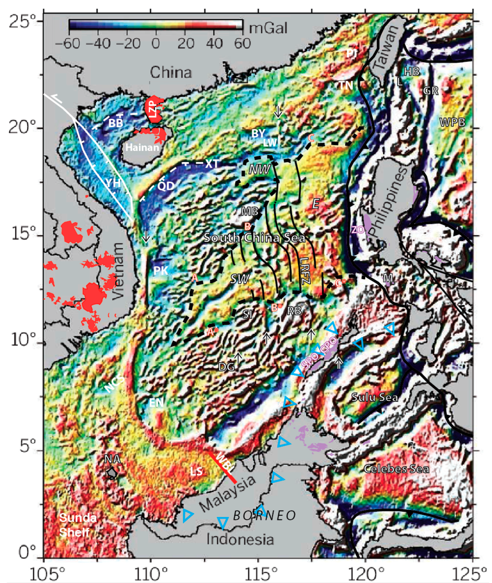
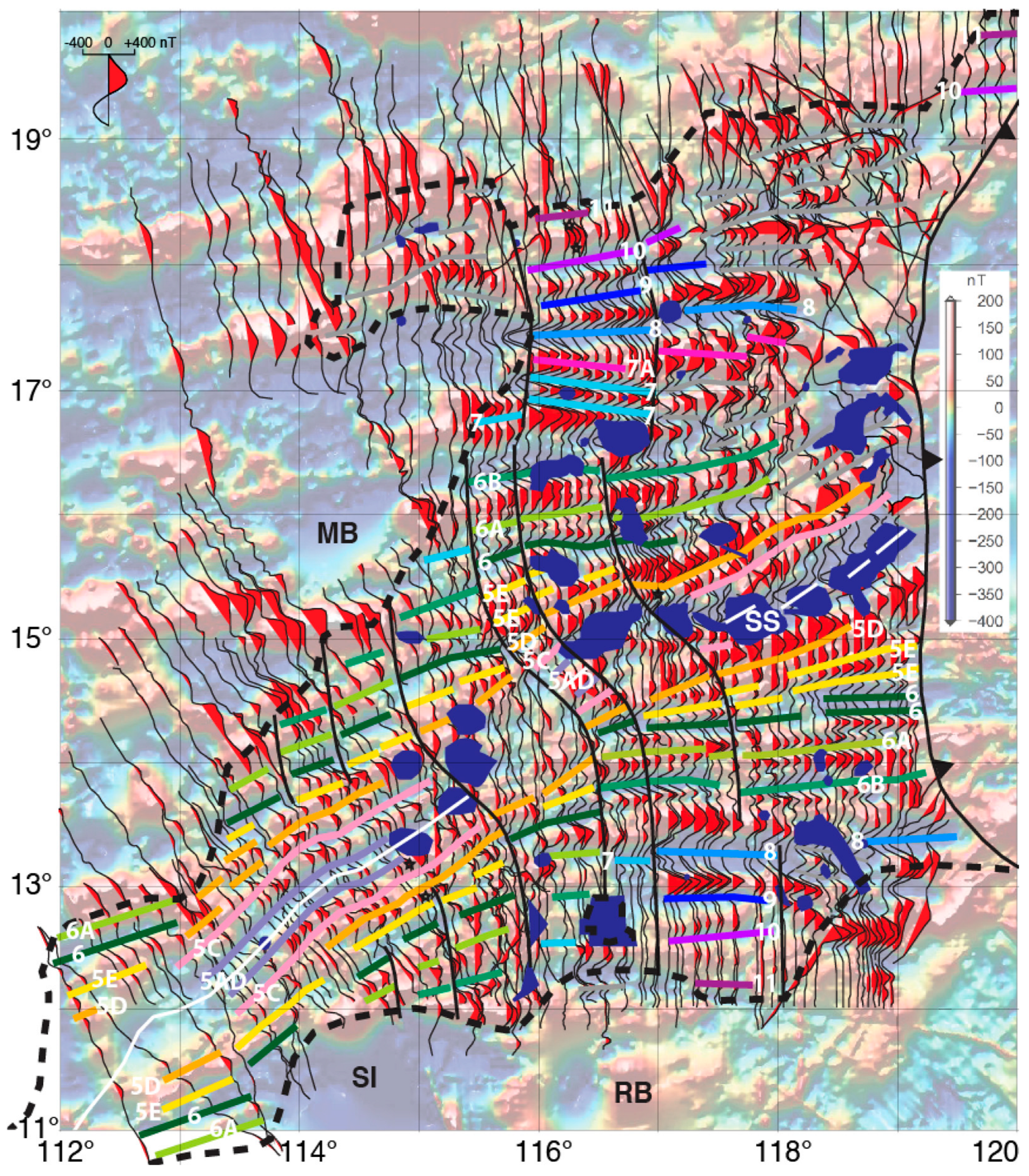
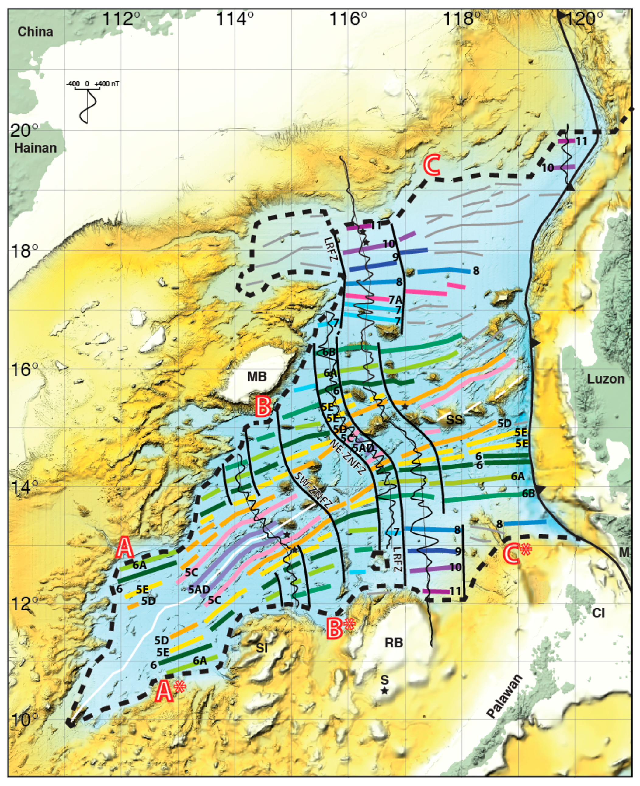
2. Seafloor Spreading

My first research cruise to the SCS was in spring 1977 on R/V Vema 3404. The data collected on that cruise, subsequently on R/V Vema 3604/5 cruises, and prior transits (notably R/V Robert Conrad 1710) permitted the identification of seafloor spreading magnetic anomaly lineations 11n-5En, the axial Scarborough Seamount chain in the eastern sub-basin, the negative free air gravity anomaly signature of the relict spreading center axial graben in the SW sub-basin, and basement ridges and troughs associated with fracture zones between the eastern and SW subbasins. That, together with the regional geology (e.g., [2,13,14]) and some commercial well data, provided the framework to propose the mid Oligocene through Early Miocene opening history of the SCS basin [1,4].
Pautot et al. [15] and Briais et al. [16] extended the identification of the axial magnetic lineations to 5C and the interpretation of anomalies to the NW and SW, as well as the eastern, subbasins. Basically, the magnetic anomaly lineations have been known for the whole basin since the data compilation of Ishihara and Kisimoto [17], but their identification has remained contested. Guan et al. [18] and Qiu et al. [19] further extended the youngest anomaly identification to 5AD and 5B, respectively. Alternative anomaly sequences and spreading rates have been proposed, but are not widely accepted: some papers used only a subset of the available data, some models propose spreading rates faster than indicated by the basement roughness (e.g., [20]), and others propose spreading where seismic data indicate the presence of hyperextended continental crust (e.g., [21]). Li et al. [22] used IODP 349 drilling results and deep-towed magnetic profiles to develop a crustal age model that “is closer to or more consistent with the early models of Taylor and Hayes (1980, 1983) and Briais (1993) than to other proposed models”. Anomaly identifications in the NW sub-basin have always been questioned given that they are not axi-symmetric, have few reversals, and are partially overprinted by seamount anomalies. Even where the sequence of anomalies is most accepted, in the eastern subbasin, the pattern and age of ridge jumps and reorientations is variously interpreted, sometimes by authors from the same institution using the same high-resolution data/maps (e.g., [18,23]).
To reappraise the situation, I compiled in Figure 2 all the published magnetic anomaly profiles over the oceanic crust on one map at a common scale, only omitting a few crossing profiles for clarity: i.e., where their inclusion would obscure other data [4,15,16,18,20,21,22,24,25]. The anomaly profiles are superimposed on the sunlit magnetic anomaly map of Ishihara and Kisimoto [17]. Although I have access to higher resolution maps, they have not been published for the whole (notably, SW) basin [18,23,26].
My interpretation of the data is overlain on Figure 2, with magnetic lineations color-coded where identified with the GPTS and grey where not, offset by curvilinear fracture zones in black, overprinted by seamounts in dark blue, between the continent-ocean boundaries (dashed) and west of the Manila Trench (barbed). The interpretation is shown over sunlit bathymetry in Figure 3, with magnetic anomaly profiles interpolated along three margin-to-margin seafloor spreading flowlines. Those flowline profiles, plus a short segment from the NE, are also shown in Figure 4, where the anomalies are identified relative to the GPTS of Ogg [27] and average seafloor spreading rates are calculated. Also shown in Figure 4 are my identifications of the oldest magnetic anomaly lineations corresponding to Chrons 8 to 11 on the conjugate north and south sides of the SCS basin. Note that, as per the models shown in references above [4,15,16,18,19,20,21,22,24], positive magnetization produces negative magnetic anomalies for east-trending lineations at this latitude. Correspondingly, the magnetic lineations are drawn through the center of the negative anomalies, except for the W-shaped anomaly 11 where they are drawn on the small mid-Chron positive.
Comparison of the magnetic anomalies with the modern GPTS shows that the initial SCS spreading rates in a central spreading segment of the basin between conjugate pairs of fracture zones averaged 62 mm/yr from 30–24 Ma (half rates of 31 mm/yr to both the north and south, Figure 4). That is slightly faster and younger than the original estimates (5 cm/yr and 32–25 Ma [4]) because of the revised GPTS, which compresses the age range of Chrons 11–7 ([27] cf. [31]). The amplitudes of the oldest magnatic anomalies (10 and 11) are reduced where buried under more than 2 km of sediments, especially NNE of Reed Bank (Figure 2 and Figure 4). The azimuth of the magnetic lineations between the two fracture zones is seen to rotate slightly counter-clockwise from anomaly 11 to 10, then clockwise from anomaly 10 to 9 to 8 (Figure 4). This is the pattern expected for the ridge rotation model of spreading ridge reorientation [32].
The clockwise rotation of the central spreading ridge segment continued from magnetic anomaly 8 to 7A to 7 and the bounding fracture zones changed orientation accordingly (Figure 2 and Figure 3). By anomaly 7 time (24.5 Ma), the first spreading south of the NE continental extension of Macclesfield Bank had begun [16], in the process stranding a small continental block north of Reed Bank [18,20,33]. However, the orientation of this initial spreading of the SW sub-basin was like that of the initial spreading of the central segment (i.e., slightly north of east), not the orientation that the latter had become (somewhat south of east). There followed during Chron 6Cr, and about the time of the Oligocene-Miocene boundary, a southward ridge jump and reorientation that reorganized the spreading segmentation (offsetting westward the eastern fracture zone of the central corridor), left all of magnetic anomalies 7 and 7A on the northern side of the eastern subbasin, and decreased the spreading rates [4,16,18].
Further east, successive southward ridge jumps are inferred to have occurred previously between the COB and anomaly 8 in order to explain the proximity of the two in the south but their separation in the north (Figure 4). Though magnetic lineations are present, their identification is uncertain (hence shown in grey on Figure 2, Figure 3 and Figure 4) and competing ridge jump patterns and ages have been proposed using the same data [18,23]. This uncertainty is compounded in the south by seamount overprinting. Likewise to the west, in the NW sub-basin, the magnetic anomalies are lineated, but their identification is controversial and partially overprinted by seamount anomalies [16,20,23]. Nevertheless, the similarity of sediment thicknesses on seismic data south of the northern COB [4,9,34,35] suggest a similar age for the basement there. Of note is the northeasternmost corner of the basin where two short E-W magnetic anomaly lineations occur between the COB and the Manila Trench (Figure 2, [21,33]). I identify these anomalies as 11 and 10, with comparable spreading rates to those observed in the central spreading segment (Figure 4).
The breakup of the SW rifted margins and initial seafloor spreading progressed two segments at a time and offset by fracture zones, with the first identified magnetic anomalies in the SW subbasin being 7 and 7, then 6B and 6B, then 6A and 6A (Figure 2 and Figure 3). The orientation of the anomalies is ENE through anomaly 6 in the SW subbasin, whereas it stayed E-W until then in the eastern subbasin. By anomaly 5E time (18.5 Ma), a counter-clockwise rotation of all the SCS spreading segments was underway [18]. In the east this included ridge jump reorientations after anomalies 6 as well as 5E, and in the SW after anomalies 5D. The youngest magnetic anomaly lineations (5C, 5B, and 5AD) trend NE, the spreading jump reorientations having removed all but the four central transform faults (now fracture zones) that trend NW at this time. The average full spreading rates younger than 23 Ma increase to the NE from 34.5 mm/yr to 38.5 mm/yr on the three flowline profiles shown in Figure 4, consistent with a distant pole of opening to the SW. My magnetic anomaly identifications of this age agree with [18] in the eastern subbasin and [19] plus 5AD in the SW subbasin and date the youngest spreading as 14 Ma (Chron 5AD, [27]). In the eastern subbasin, however, most of the youngest lineations are overprinted by anomalies associated with the axial Scarborough Seamount chain (Figure 2, Figure 3 and Figure 4). The post-spreading axial and off-axis seamounts between 13–16.5° N are dated 3–11 Ma ([6,15,36] and references therein).
Bathymetry and gravity data (Figure 1 and Figure 3) show a disconnected series of basement highs trending ~N10° W from the NW corner of Reed Bank (Liyue) towards the NE corner of Macclesfield Bank (Zhongsha), which has been called the Zhongnan Ridge and interpreted as a fracture zone ridge (e.g., [10]). The integration with more magnetic anomaly data, however, shows that the northern and southern portions are associated with different fracture zone conjugates, offset by central segments trending NW, orthogonal to the rift axis of the SW subbasin (Figure 3 and Figure 4, [18,20,33]). The northeastern of these (here termed the NE Zhongnan Fracture Zone, NE-ZNFZ) ends to the south at a block north of Reed Bank, as per the previous references. Dredges of the southern highs bordering the southwestern fracture zone (SW-ZNFZ) recovered Mesozoic granitoids (124 Ma adakitic granodiorites [37]), indicating the presence of rafted continental blocks and that not all the seamounts in the basin are volcanic. A rafted block may also explain an otherwise enigmatic date on a dredged sample from a seamount at 17°15′ N, 118°43′ E that recovered sheared oceanic plagiogranite. Although there are no identified magnetic lineations near the seamount, the Ar40/Ar39 date on pyroxene of 32.3 ± 0.5 Ma [38] is older than those in the eastern subbasin would predict (Figure 3 and Figure 4). There is just one throughgoing fracture zone that connects the northern and southern rifted margins of the eastern sub-basin, herein named the Liwan-Reed Bank Fracture Zone (LRFZ, Figure 3). In the north it offsets the continent-ocean boundary (COB) south of the Liwan Sag and forms the boundary between the eastern and NW sub-basins of the SCS (Figure 1, though confusingly also called the ZNFZ by [39]). In the south, it terminates at the COB in the center of Reed Bank at 117°E and forms the boundary between the eastern and SW sub-basins of the SCS.
Concerted efforts by the International Ocean Discovery Program (IODP) were made to date the oceanic basement of the SCS, with mixed results. To constrain the age of the youngest spreading, two sites (U1433 and U1434) were drilled slightly south of the SW axis near 115° E on crust that I correlate with Chrons 5Br and 5Dr, respectively, and another (U1431) to the north of the axial seamounts of the eastern subbasin at 117° E on Chron 5Cr (Figure 2, Figure 3 and Figure 4; [22,40]). Biostratigraphic datums show that sediments overlying basement at the SW sites are younger or of similar ages to those correlated between the modeled surface and deep-towed magnetics and the GPTS (12–18 Ma, Site U1434; 18–21 Ma, Site U1433; [19,22]). In contrast, radiolarian claystone (16.7–17.5 Ma [40]) intercalated with basalt (Ar40/Ar39 dated at 17 Ma [41]) precisely confirm the Chron 5Cr correlation at Site U1431. This equates with an end to SCS seafloor spreading at 14 Ma in my interpretation (Figure 1, Figure 2 and Figure 3) and that of [18]. Note that this permits the 14–18 Ma east Taiwan ophiolites to be accreted from the youngest SCS crust [42]. The age of the oldest SCS oceanic crust has not yet been constrained by radiometric dating, despite several IODP sites such as U1500 and U1503 recovering basement basalts. Nevertheless, the biostratigraphic constraint from the sediments overlying basement, most precisely dated by nannofossils as younger than 30 Ma at site U1500, is consistent with that sites “alignment with magnetic Chron C11n” (Figure 4, [43]).
My compilation and revised interpretation of all the published magnetic anomaly profiles in the SCS basin (Figure 2, Figure 3 and Figure 4) draws on the best input from many authors. It confirms the original identification of anomalies 11n-5En [1,4] and extends that and those of Briais et al. [16] to younger anomalies (5Bn) in both the eastern and SW subbasins, informed by Guan et al. [18] and Qiu et al. [42], respectively. It improves the location of the COB and fracture zones, distinguishes the Liwan-Reed Bank Fracture Zone from both the NE- and SW-Zongnan fracture zones, and documents the ridge jump reorientations associated with the change in spreading direction from ~N-S before 23 Ma to NW-SE after 17 Ma. It provides an integrated breakup and spreading history for the eastern and SW subbasins, correlated to the most recent GPTS, with spreading rates updated accordingly (Figure 4). There remain uncertain magnetic lineation correlations in the NW subbasin and in the NE quadrant of the eastern subbasin, the latter in part due to a lower data density (Figure 2 and Figure 3). Additional data are also needed south of 13° N and west of 114° E across the SW spreading tip.

3. Continental Rifting

The rifted margins of the SCS, like those of other marginal basins, are in many respects different from those in the Atlantic, for several reasons [5,6,7,8,9]. Principal among them is the strain rate, which was much faster, assuming continuity with the initial spreading rates of over 6 cm/yr (compared to <4 cm/yr and mostly ≤2 cm/yr in the Atlantic [44]). This is likely related to their connection to subduction zones nearby and rifting the orogenic edge rather than the stable/cratonic interior of a continent, facilitating faster motion of a smaller plate. The second reason is structural and thermal inheritance: the south China margin did not start in tectonic or thermal equilibrium. Only ~5–10 m.yr. before the onset of Cenozoic rifting, the SE China–Hainan–Vietnam–Natuna–SW Borneo margin was an Andean volcanic arc, with Mesozoic granitoid magmas emplaced as young as 70 Ma (e.g., the high-K calc-alkaline 73 Ma Longlou I-type granite on Hainan), capable of generating considerable radiogenic heat and contributing to its high heat flow [14,45,46,47,48,49,50,51,52,53,54,55,56,57]. Southeast of the arc there is a former forearc basin comprising a thick Mesozoic (meta)sedimentary section with folds, thrust faults, and widespread top erosion; these continue on the SE margin of the SCS and are bordered further SE by Mesozoic accretionary/collision complexes in the northern Palawan/Calamian block [54,58,59,60,61,62,63,64,65]. The thick Mesozoic sediments are associated with, and are the likely cause of, a magnetic quiet zone observed there [10]. Third, the rifting of this young, hot, orogenic margin was accompanied by extensive syn- and post-rift magmatism, which was distributed rather than focused [6,51,66,67,68,69,70]. This both augmented the crust, partially offsetting extensional thinning, and made it more ductile. These three factors contributed to a wide rifted margin with a narrow (5–15 km wide) continent-ocean boundary (i.e., comparable in width to a spreading center plate boundary [71]), with neither exhumed mantle nor seaward dipping reflectors [9,35,43,72]. The SCS rifted margins do not fit within the bimodal Atlantic paradygm of magma rich versus magma poor end members (e.g., [73,74]) and require a multi-variate classification in which strain rate is one of the primary variables, as also seen in the Woodlark Basin and which has long been recognized at seafloor spreading centers [5,6,7,8,9,75].
Even among marginal basins, the SCS is exceptional in the wide extent (2000 km north to south) and long duration of its rifting (from rift onset at the beginning of the Cenozoic until at least the end of spreading at 14 Ma). Rifting and spreading together produced the opening of the SCS, with the proportions due to each (and hence the width of the margins) varying greatly through time and from east to west: over 700 km of spreading in the eastern subbasin was matched by almost that much additional extension of the margins west of the SW subbasin, which never reached breakup (Figure 1 and Figure 3). Although conjugate salients and re-entrants in the COB can be recognized, joined by seafloor spreading flowlines (e.g., points A, B, C to A*, B*, C* in Figure 1 and Figure 3), the conjugate margins can not be simply/rigidly reconstructed given the substantial differential extension within them. Furthermore, rift systems in the SCS have been shown to be diachronous along as well as across strike such that syn-tectonic sequences in the distal/western margin can occur at the same time as post-tectonic sequences in the proximal/eastern margin (e.g., [76,77,78,79,80,81]).
It is important, therefore, for descriptions of continental rifting to be specific regarding where as well as when. Accordingly, in this paper, I focus on the central segment of the northern SCS margin, south of the Pearl River (Zhujiang) mouth, where the quality and quantity of published geophysical and drilling data is unsurpassed. Notably, the sequence stratigraphy and rift architecture are well established by many commercial and IODP wells and full crustal/3D seismic profiling, which permits isochron/isopach mapping of large areas (Figure 5, Figure 6 and Figure 7, [68,69,70,82,83,84,85,86,87,88,89]). The grids of multichannel seismic data were collected primarily orthogonal and parallel to the ENE-trending coastline and offshore structural highs/lows. I have taken the opportunity afforded by the exceptional dataset to construct a series of full crustal cross sections from the middle to distal margin and oceanic crust that are aligned with the dominant N-S kinematic transport direction of the extensional deformation (Figure 7). That N-S direction is defined by mega-corrugations on the Liwan, Kaiping, and Enping as well as southern Dangerous Grounds metamorphic core complexes [86,90,91,92,93,94,95], by the N-S transfer faults bounding the Spratly Islands, east of Liwan sag and its conjugate east of Reed Bank, and by other tectonic elements such as the east Vietnam transform margin and Ulugan Bay fault of Palawan (Figure 1). Four of these sections (A-D) in Figure 7 illustrate extensional corridors within the basement isochron and crustal thickness isopach maps of Figure 6. The fifth section (E) is further east at 118° E, on the east side of the Dongsha uplift, and is based on the deep seismic reflection profile published by Pan et al. [96] plus a short southern continuation onto oceanic crust (from profile T3 of Zhang et al. [9]). The cross sections are in two-way travel time (TWTT), thereby preserving the primary observable: reflection time. Comparisons may be made to the several velocity-depth sections in the area provided by refraction/wide-angle reflection profiles shot to ocean bottom seismometer arrays [97,98,99,100,101,102,103,104].

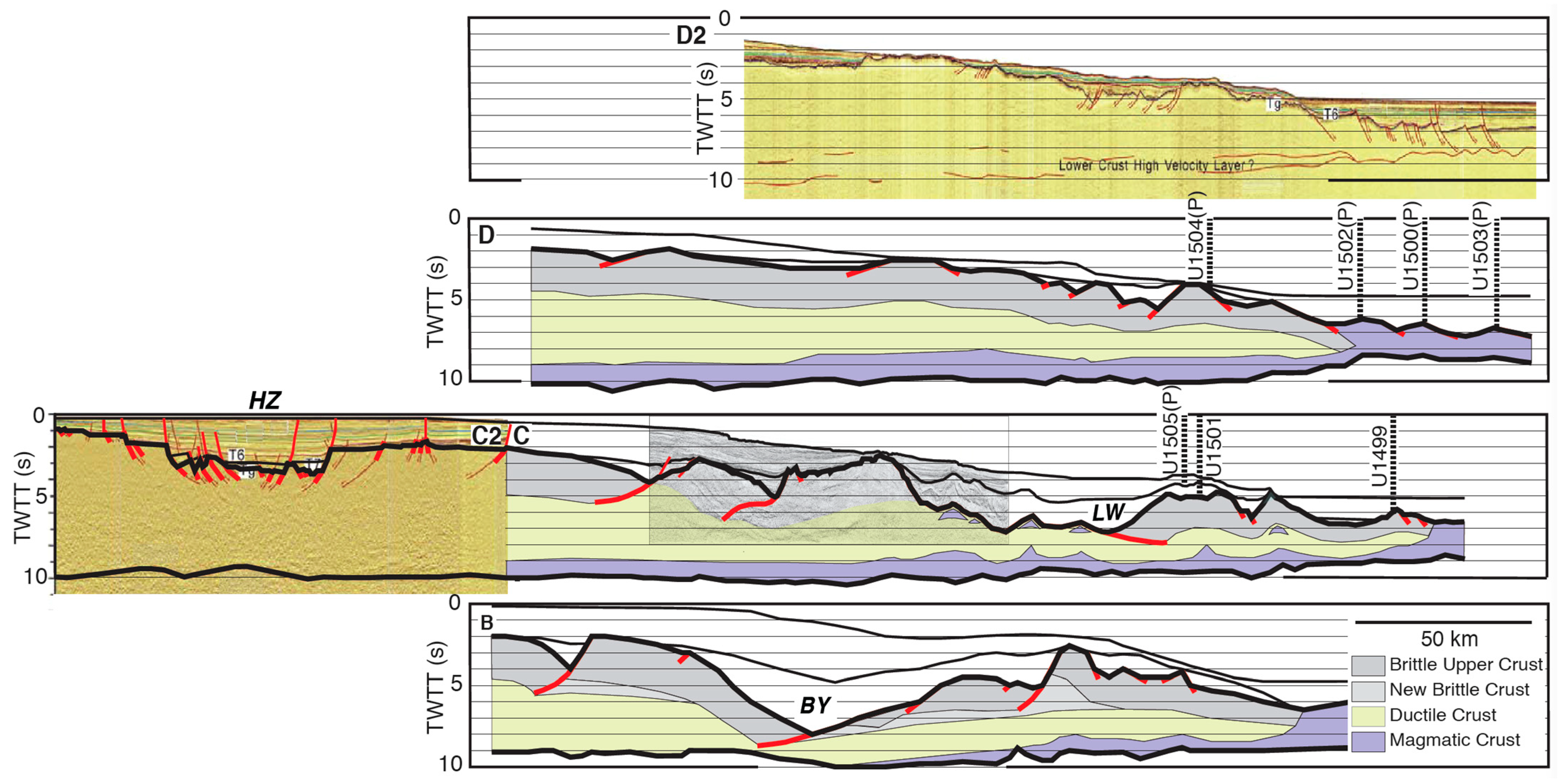
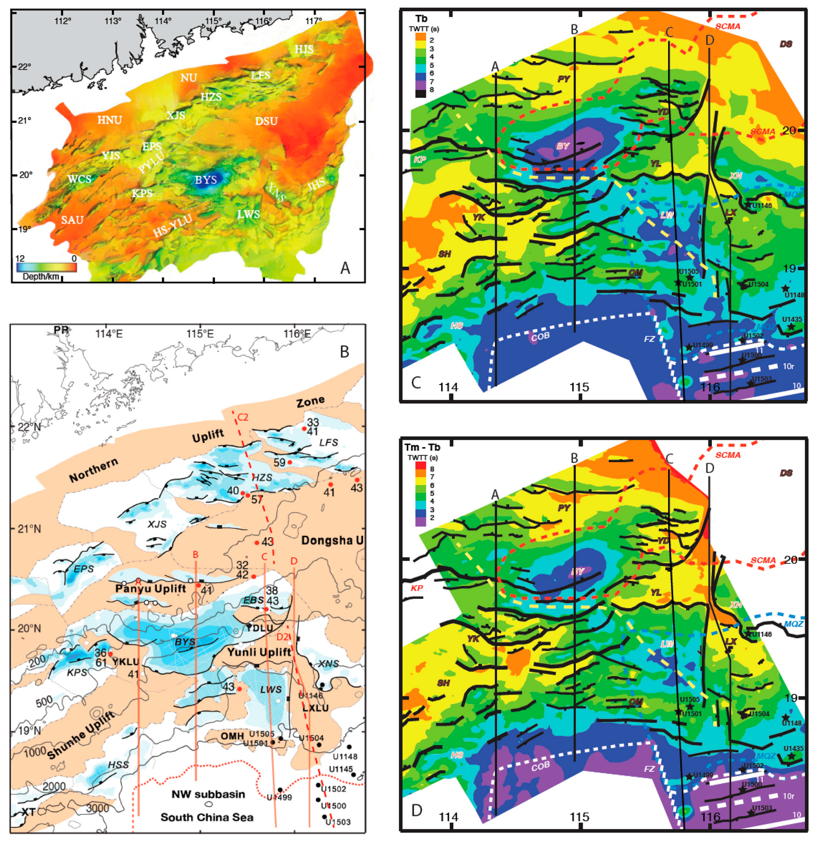
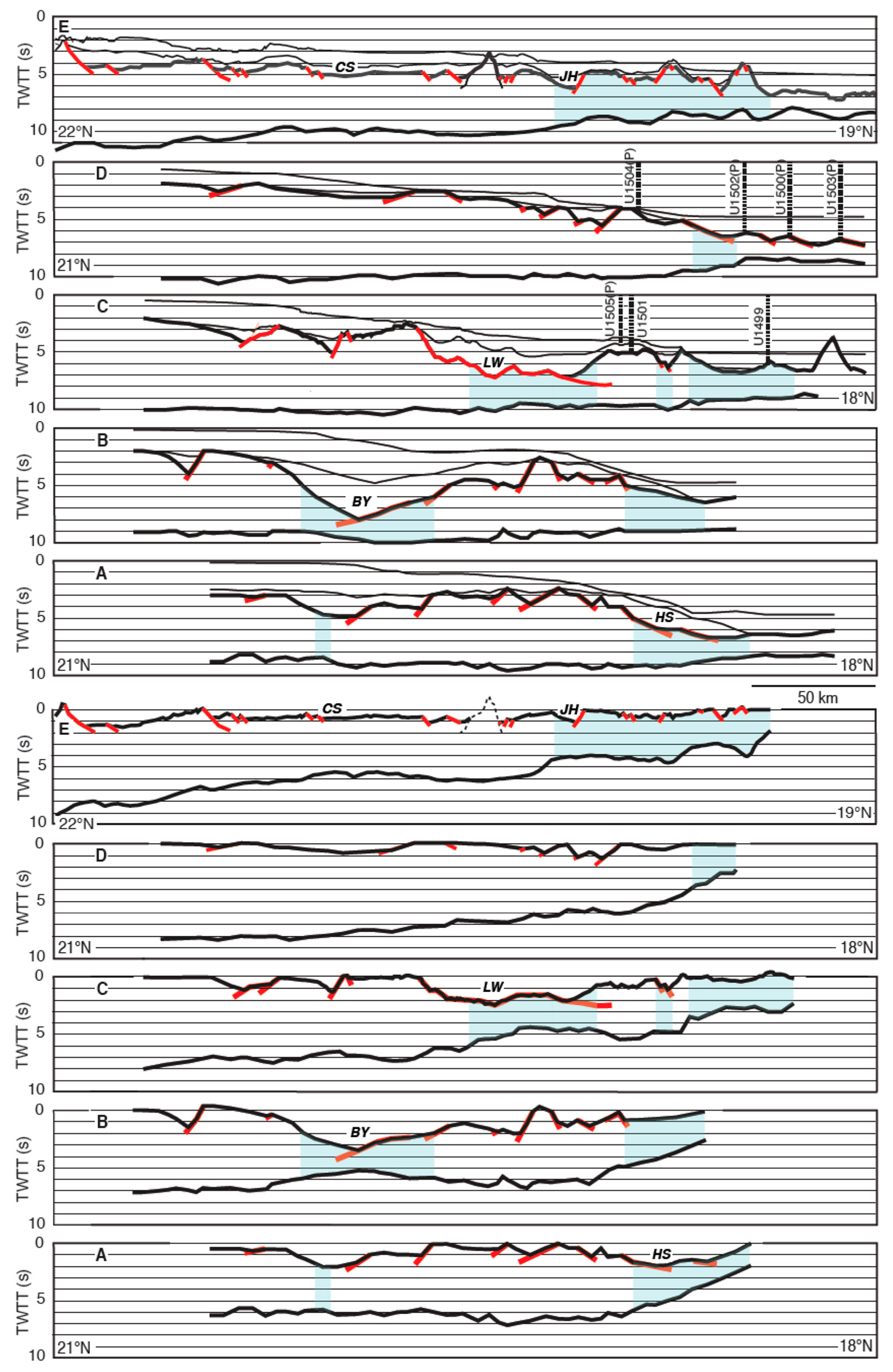
3.1. Seismic Stratigraphy

The China National Offshore Oil Company (CNOOC) has developed a detailed seismic sequence stratigraphy and event chronology for the PMRB (as published, for example, in [68,88]), based on integration of their extensive core-log-seismic data. I adopt their synthesis with modifications for the time-transgressive T60 unconformity (Figure 5) as drilled at the IODP Sites on the distal margin (e.g., [9]).
In conjunction with the seafloor spreading history described in Section 2, this immediately raises issues with respect to correlation, timing, and terminology, notably the use of the terms “breakup unconformity” and “syn-rift”, which we shall come to below. The traditional view is that rifting occurs between rift onset and breakup, each of which may be associated with unconformities that bound the syn-rift stratigraphic sequence [107]. In the northern SCS, the rift onset unconformity (Tg) is encountered at 58 Ma off Taiwan [108], 56.5 Ma in the PRMB Kaiping sag [95], and 66 Ma in the onshore Sanshui Basin [109]. Diachronous initial deposition followed widespread Late Cretaceous uplift and erosion under arid conditions associated with sparse terrestrial red beds (e.g., [61,110]. The Eocene saw three phases of terrestrial rifting, with sediments accumulating in inter-montane lakes punctuated by unconformities at T83, T80, and T70 (Figure 5). The top of the terrestrial syn-rift sequence (T70) is correlated with the Eocene-Oligocene boundary, ca. 33.9 Ma, which is also the revised date for the large (~70 m) global sea level fall associated with the onset of Oligocene ice-house conditions [111,112]. Although unconformable on the proximal margin, where drilled by IODP on the distal margin, T70 is a conformable paralic sandstone to marine claystone transition (e.g., [9]). Continued subsidence led to conformable marine clays being deposited across the time of initial breakup (30–29 Ma): i.e., there was no breakup unconformity in deep water on the northern distal margin [96], as Falvey [107] anticipated and as also demonstrated in the Woodlark rift [113]. T70 has been genetically correlated with breakup but, as breakup did not begin until 4 m.yr. later, it rather correlates with the large global sea level fall. On the shelf and proximal margin, the T70 hiatus could be 34–30 Ma and correspond to erosion resulting from the large fall in global sea level until that was offset by further thinning-related subsidence (Figure 5, e.g., [114]). Nevertheless, T70 is an important stratigraphic marker that represents when the northern SCS margin was at or above sea level.
Seismic and well information from the southern conjugate margin tell a complementary story, where unconformities on the crests of horst blocks transition to being conformable in deeper waters [79,106]. In the Sampaguita-1 well on Reed Bank, an actual breakup unconformity (i.e., ~30 Ma) occurs during the shaoling transition from Late Eocene and Early Oligocene marginal marine sandstones and siltstones (i.e., deeper water than the latest Eocene paralic sandstones in the north) to Upper Oligocene (28 Ma) and younger bank carbonates, accompanied by a reversal in the clastic drainage from NW (China) to SE (Palawan) [1,115].
In the SCS, rifting did not stop with breakup of the eastern conjugate margins. Rather, it continued through the ridge jump reorientation at T60 and the step-wise breakup of the SW conjugate margins from 24.5–20.5 Ma, including the southward ridge jump over Macclesfield Bank by 22.5 Ma, and at least until spreading stopped at 14 Ma (Figure 2, Figure 3, Figure 4 and Figure 5). This has been associated with a commensurate SW younging of the rift stratigraphy and unconformities [29,76,79,81,116,117] such that, for example, in the Qiongdongnan Basin, the extension and subsidence rates were highest from 34–23 Ma with a breakup unconformity ca. 23 Ma [118,119,120], and in the basins ahead of (Nam Con Son) and adjacent to (Phu Khan and East Natuna) the SW SCS seafloor spreading tip, rifting continued until 12–10.5 Ma [78,79,121,122]. The conjugate margins adjacent to the eastern subbasin also continued to extend post breakup, though the rates significantly decreased. This is particularly noticeable from an analysis of fault heaves in the Dangerous Grounds area (though they are mostly adjacent to the SW subbasin [106]) but is also exemplified by the small fault offsets of horizons T60 to T32 on the northern margin (e.g., [88,114,123,124]).

3.2. Rift Architecture

The plan view of the rift architecture of the Pearl River Mouth Basin (PMRB) is shown in the sunlit depth to basement map of Figure 6A (modified after [87]) and the principal border faults on Figure 6B (modified after [69]). Beneath the continental shelf, south of a northern zone of uplift, a series of overlapping, en echelon, subbasins (or sags) parallels the coastline and occupies the proximal rift zone collectively known as the Zhu I Depression in the northeast-center and Zhu III Depression in the southwest [86,90,93,125,126,127,128,129,130,131]. Seismic profiles show that these rifts are graben and half-graben that formed by partially reactivating two generations (Indosinian and Yanshanian) of Mesozoic thrusts that trend WNW (275–295°) and ENE (060–080°), respectively, under Early-Middle Eocene NW-N20° W extension that transitioned to Late Eocene and younger N-N5° E extension [87,90,93,127]. Of 94 wells drilled into the pre-Cenozoic PRMB basement, 2 encountered Mesozoic sediments (LF35-1-1, MZ9-6-1 [64]) and 84 of them intersected granitoids [90], with U-Pb dates on their zircons between 164–100 Ma and a wider range of K-Ar dates between 196–70.5 Ma [52,54,132,133]. From the central PRMB to Taiwan, the former Andean arc front is marked by the positive South China magnetic anomaly (SCMA) that subparallels the coastline (Figure 6, [54,61,105,134,135]).
The proximal rifts are bordered to the SSE by basement highs: Dongsha Uplift in the east and Shenhu-Ansha Uplift in the west, with the deeper Panyu Low Uplift in between, which is cut by a few east-trending half graben (Figure 6, [88]). The Dongsha and Shenhu-Ansha Uplifts continue south to the distal margin whereas the Panyu Uplift is bordered by the Kaiping and western-central-eastern Baiyun sags, which also formed over Cretaceous granitoid basement [66,70,83,85,89,92,95,96,105,114,123,125,136,137,138,139,140,141,142]. Further south, from west to east, the distal margin includes the Shunhe Uplift and Heshan Sag, the Yunli Uplift, Liwan Sag, and Outer Margin High, the Xingning Sag and Lixing Uplift, and the Jinghai Sag (Figure 6, [9,68,69,85,91,105,143,144,145,146,147]).
Within the PRMB, the central Baiyun Sag is an anomalously deep hole formed above a north-dipping detachment that thinned the crust to less than 2 s TWTT (Figure 6 and Figure 7). This failed rift is thought to have localized at the intersection of inherited basement features, including oblique strike-slip faults and an old suture [70,138,142,148]. It is unlike its surroundings: highs that remained subaerial until T70 and rifts that detached at mid-crustal levels above a ductile lower crust [83,85,95,139,146,147]. For example, the upper crust of the Outer Margin High separated from the Yunli Uplift and moved south above a low-angle detachment to form the Liwan Sag (cross-section C, Figure 7), bordered to the east by a west-dipping N-S sinistral transfer fault (Figure 6C, [91,142,149]). As seen on cross-section D (Figure 7), the basement high to the east of the East Baiyun and Liwan sags slowly tapers across the margin until finally necking down south of Site U1504 to the COB.

3.3. Deformation Styles

Sheath folds imaged beneath Liwan Sag in 3D seismic data show that the mid-lower crust there stayed ductile and more than 2 s TWTT thick while the upper crust pulled off above a detachment [146,147]. Hao et al. [69] conclude that Liwan is characterized by ductile flow and magmatic underplating of lower crust that hyperextends more than necks hot crust associated with widespread syn-rift magmatism, especially 43–40 Ma (Figure 6B and Figure 8). Likewise, Li et al. [95] showed, using a 3D seismic grid of the Kaiping area, compelling evidence of a detachment fault decoupling localized faulting in the brittle upper crust from simultaneous flow of the ductile lower crust beneath. The central PRMB region abounds with examples of ductile flow of lower crust and/or syn-tectonic magma additions into the footwall of exhumation surfaces such that the lower crust did not fully embrittle (Figure 8, [67,68,70,89]). Furthermore, seismic and drilling data [150,151] show that the Early Cretaceous mylonitic basement at Site U1504 was subaerial at T80 and near sea level at T70 (reef debris). South of that site to the COB, the basement and on-lapped syn-rift sediments were offset by high-angle faults between T70 and T60. Any detachment faulting on that basement at T80 or before was not responsible for the late rift crustal thinning 38–30 Ma that preceded breakup, thinning of which was achieved there by both high- and low-angle normal faulting above ductile flow of the lower crust.
Figure 8. Interpretation of crustal cross-sections B-D from Figure 7, plus two sections (C2 and D2, located in Figure 6B) of seismic profile 2 of Gao et al. [137] and one underlay of profile 6A from Hao et al., [69], illustrating the styles of PRMB crustal extension: high- and low-angle normal faulting of the brittle upper crust above ductile flow of the mid-lower crust, accompanied by magmatic underplating and intrusion. New brittle crust formed by ductile flow into the footwall of exhumation faults. Thin spots such as Baiyun and Liwan sags (BY, LW) were held together by surrounds of less extended crust (e.g., section D) that gradually tapered across the margin until breakup resulted from focused magmatism at the COB. HZ = Huizhou sag.
Geosciences 15 00152 g008
Collectively, these examples show that, in contrast to Atlantic margins, in the northern SCS central segment, full embrittlement of the crust was never reached: brittle faulting (high- and low-angle) of the upper crust was accompanied by, and typically decoupled from, ductile flow and magmatic underplating of the lower crust. Thin spots in the extending continental crust (localized by inherited basement weaknesses, e.g., failed rifts such as the central Baiyun sag) were held together by a surrounding mesh of less extended crust (Figure 6, Figure 7 and Figure 8). The thinned crust was kept ductile and replenished, in part, by magmatic additions (e.g., [67]). At a regional scale, especially in the western SCS, a good case has been made for crustal boudinage [122,146,149,152,153,154,155]. Thermomechanically, the SCS rifts developed in a recently hot arc and hydrated forearc where the mantle was weak compared to the crust, as in the crème brûlée model of Burov and Watts [156].
Notwithstanding the overall southward crustal tapering and thinning of the northern margin (Figure 7 and Figure 8), the southern uplifts of the PMRB were still terrestrial and near sea level at the end of the Eocene (T70), as confirmed by drilling at IODP sites U1435, U1501, U1504, and U1505, only 4–5 m.yr. before the 30–29 Ma (C11n-C10r) breakup along that margin that by then had subsided to bathyal depths [43]. The rapid extension and subsidence of the distal continental margin were recorded there and at IODP Site 1148 by the conformable deposition of paralic sandstones transitioning to marine claystones (Figure 5, [9]). The thinning of the crust and breakup of the lithosphere were achieved in concert with decompression melting of ascending asthenosphere that focused magmatism on what became the COB [35,67]. Even so, as seen elsewhere [157], the segmentation of the mantle melting and seafloor spreading was not simply inherited from the syn-rift fault segmentation: witness the offset between the LRFZ and the conjugate transfer faults east of Liwan (Figure 6) and east of Reed Bank (Figure 1). Transform faults (such as the LRFZ) formed at/after breakup to link offset spreading segments, and spreading reorganization/reorientation was common as successive margin segments broke up along strike to the SW (Figure 1, Figure 2, Figure 3 and Figure 4, [5,157]).

3.4. Cenozoic Magmatism

Lacking evidence of seaward dipping reflectors (SDRs), and evidencing a magnetic quite zone (MQZ), the central-eastern SCS conjugate margins were long thought by many, including myself, to be magma-poor (e.g., [76,77,158,159]). Increasingly high resolution seismic data and precisely dated samples, published mainly in the last decade (e.g., [67,69,70,103,160,161,162,163]), however, reveal widespread and diverse Cenozoic magmatism and volcanism, the temporal distribution of which is graphically depicted in Figure 5 and the spatial distribution in Figure 1 of Sun et al. [141] and of Xia et al. [36].
Paleocene to Middle Eocene (63–43 Ma) volcanism in the PRMB, Sanshui Basin, and Penghu Islands was bimodal ([51,164,165,166] and references therein) and similar sources persisted all around the SCS to the Quaternary [167]. Volcanic mounds and magmatic sills were emplaced during the intense rifting stage (~43–38 Ma in the Baiyun sag and 44–34 Ma in the Kaiping sag, [70]). Syn-spreading magmatism on the northen continental margin includes basalts in the PRMB and SW of Taiwan, with ages from 27 to 16.5 Ma [51,66,165,166,168] and notably 23.8 to 16.5 Ma in Baiyun sag [123,141,148,163].
Post-spreading basaltic volcanism of the intra-plate type is widespread and peaked during the Pliocene-Holocene. In addition to seamounts in the SCS basin (Figure 2 and Figure 3, [6,36]), it includes volcanoes and intrusions in the Dangerous Grounds [169], Indochina/Vietnam (Figure 1, [167]), Qiongdongnan Basin and Xisha Trough [36,160], Hainan and LeiZhou Peninsula (Figure 1, [170,171]), Dongsha Rise [137,172,173,174], and the Penghu Islands west of Taiwan [168]. Zhao et al. [175] termed this the SE Asian Basalt Province and related its sources to widespread low-Vp anomalies in the mantle beneath. Though the strongest of these anomalies occurs below Hainan, Zhao et al. infer that there are multiple weak plumelets rather than the widespread volcanism originating from a single deep plume. Chen et al. [176] note that these mantle low-Vp anomalies occur around the edges (particularly the northern and western edges) of a high-Vp anomaly in the mantle transition zone, thought to represent a stagnant former slab beneath the SCS [177,178,179,180].
The northern SCS distal margin has a high velocity lower crust (HVLC, Vp = 7.0–7.5 km/sec) that has been inferred to reflect syn-rift underplating of mafic magmas [97,98,99,103,181]. It might also be explained, in part, by high-grade (amphibolite) metamorphism of the lower crust [107]. The two are not mutually exclusive, given that magmatic underplating would likely produce such metamorphism, and distinguishing rock types from seismic velocities (and densities) is non-unique (e.g., [182]). Nevertheless, magma underplating is consistent with the widespread syn-rift volcanism now demonstrated in the high-resolution seismic sections and dated side-wall cores referenced above.
Northeast of Dongsha Atoll, beneath the SCMA, the HVLC layer is exceptionally thick (12–17 km, at ESP7-7A, [45]). These authors note that this is twice the thickness of oceanic crust (i.e., much more than could be attributed to magma underplating from rift-induced mantle decompression melting) but that thick high-Vp lower crust also occurs beneath Mesozoic south China. Indeed, SINOPROBE showed that the coastal terranes have high-reflectivity lower layers beneath low-reflectivity crust, interpreted as magma-dominated crust associated with Basin-and-Range-style Cretaceous extension during slab roll-back. Magma intrusion and underplating compensated for some of the extension-related crustal thinning and produced a regionally (>100 km wide) flat Moho at 10 sec TWTT (~30 km depth, [183]). Wan et al. [100] and Cheng et al. [184] compiled all the refraction results in the NE margin and correlated the HVLC associated with the SCMA as likely pre-rift magmatism of the Andean arc, whereas that which underplates the hyper-thinned distal margin could be rift related and/or intra-plate magma intruded after rifting and spreading had ceased [76,104,184,185].

4. Proto-SCS

In the model of SCS evolution proposed by Taylor and Hayes [1,4] and Holloway [2,3], there was a large embayment of Mesozoic oceanic crust east of Indochina, south of China, and north of Borneo that predated the formation of the present-day SCS. Subduction to the south of that oceanic crust, termed by Hinz et al. [186] the proto-SCS, beneath a counter-clockwise rotating Borneo and south Palawan, opened the modern SCS by separation of Luconia Shoals-Dangerous Grounds-Reed Bank-north Palawan-SW Mindoro (LDRPM) from south China. There was a Y-shaped triple junction south of Hainan, with the overall N-S opening in the SCS being accommodated by a N-S transform fault east of Vietnam. In their model, the Paleocene-Early Miocene SCS opening stopped when the proto-SCS had been consumed, as marked by the mid Miocene collision of the LDRPM with Borneo-south Palawan (e.g., [187,188]).
Further constraints on the SCS evolution may come from consideration of the surrounding terranes. To that end, we next consider that which is below, east of, and south of the SCS.

4.1. Tomography

From Vp seismic tomographic images, Hall and Spakman [178] infer that the remnant slab of the proto-SCS now resides in the lower mantle (900–1200 km deep) in a concave-north arc beneath central Borneo and the Celebes Sea, having been overridden by the 26–11 Ma CCW rotation of Borneo-south Palawan ([189,190] but note [191,192]). As mentioned above in Section 3.4, seismic tomography also images a high-Vp anomaly at mantle transition zone depths beneath the modern SCS and Luzon, thought to represent another relict slab [177,178,179,180]. Whereas Hall and Spakman [178] speculated that this may be a remnant of Mesozoic subduction, Wu and Suppe [193] propose a double-sided subduction model in which, starting in the Eocene (ca. 50 Ma), the proto-SCS was subducted first to the south under Borneo but then, from the mid Oligocene until the early Miocene (30–15 Ma), also to the north under the LDRPM. This model makes seafloor spreading in the SCS back-arc, though they note the western Mediterranean analogue in which old lithosphere was doubly subducted and sank vertically to be replaced by young lithosphere without significant regional plate convergence (e.g., [194]). Wu and Suppe [193] also recognize a separate proto-SCS south slab at 720–820 km depth under north Borneo (from the southward proto-SCS subduction) and distinguish it from the >900-km depth Vp anomalies of Hall and Spakman [178], which they ascribe to Neotethys subduction under Sunda. Contrary to both, Hua et al. [180] trace the high-Vp anomaly at mantle transition zone depths beneath the SCS south to the Sunda subduction zone.
Thus, while seismic tomography has introduced 3D elements into plate reconstructions, such that unfolded subducted slabs should be considered in restoring paleogeography, attribution remains a contested issue, especially for relict slabs that no longer connect to the surface. Whether the sub-SCS slab is Mesozoic or Cenozoic, the mantle above it that sourced the MORB-like basalts recovered by IODP drilling and ocean island-like basalts dredged from seamounts has Indian-type Sr-Nd-Pb-Hf isotope compositions and is both water rich and trace element depleted, consistent with an enriched component (from recycled crust and sediments) mixing with a depleted mantle [195,196,197,198,199].

4.2. Ophiolites

Different insights into the proto-SCS and SCS reconstructions come from studies of ophiolites that crop out in the surrounding islands (Figure 1). Section 2 noted that the dismembered 14–18 Ma east Taiwan ophiolites may be accreted from the youngest SCS crust [42]. Luzon and the northern Philippines (including Lanyu Island, Figure 1, with radiolarian cherts 115 Ma) are thought to be constructed on Early Cretaceous oceanic crust contiguous with that in the Huatung Basin (116–131 Ma, [200]) and west of the Early Cretaceous volcanic arc of the Gagua Ridge (124 Ma, [201]). Even the arc/backarc Eocene Zambales ophiolite on Luzon (with fossil, radiometric, and 44–48 Ma U/Pb dates on zircons, [202,203,204]) has Early Cretaceous radiolarian cherts found in blocks within the overlying Miocene sediments [205]. These and the metamorphosed Cretaceous ophiolites of eastern Mindoro form part of the Philippine mobile belt that was translated northward and rotated clockwise from subequatorial regions in the early Cenozoic: i.e., they were not accreted from the modern or proto-SCS [203,204,205,206,207,208]. On the other hand, the western (Amnay) ophiolite on Mindoro has overlying sediments with middle Oligocene nannofossils that Rangin et al. [209] inferred were part of the oldest SCS trapped between the colliding Palawan block and the Philippine arc. Alternatively, Queaño et al. [205] note that the Palawan continental block that collided with the Philippine mobile belt in the Early Miocene trailed the subduction of the proto-SCS.
The co-existence of the Upper Eocene central Palawan ophiolite (CPO) emplaced on Upper Cretaceous metasediments adjacent to, but interpreted to be underthrust by, the Lower Cretaceous south Palawan ophiolite (SPO) emplaced on Eocene trench turbidites potentially complicates the proto-SCS story and geodynamic picture (Figure 1, [210,211,212]). The CPO comprises mantle hartzburgite, troctolite, gabbro, plagiogranite, diabase dikes, and massive/pillowed basalts, with U-Pb crystallization ages of zircons in the plagiogranite of 40.0 ± 0.5 and 34.1 ± 0.1 Ma, and U-Pb zircon ages and Ar40/Ar39 hornblende ages of 36–34 Ma from the metamorphic sole [213,214,215]. The associated MORB-like geochemical data have been interpreted variously as indicating seafloor spreading in either a juvenile supra-subduction zone or a back-arc basin [211,214,215,216]. The SPO and accretionary complex comprises blocks of syenite and olivine gabbro with U-Pb zircon ages of 103 and 101 Ma, respectively, intercalated with a series of thrust slices including Lower Cretaceous interbedded calcerious clay and radiolarian chert, Upper Cretaceous radiolarian chert and pelagic sediments, pillow basalts to andesites, and Upper Eocene trench-fill clastics ([210,211,216] and references therein). The mixed oceanic island-, island arc-, and MORB-like geochemistry of the SPO also has been variously interpreted, most recently as an intraoceanic arc-forearc [215]. Paleomagnetic study indicates the SPO moved north from a paleolatitude of 2.5° ± 0.6°N and rotated CCW by 66° ± 13°, in contrast to the northern Palawan block, whose paleolatitude of pervasive Cretaceous remagnetization is comparable to that in south China at ~25° N [190].
Although the Palawan ophiolites have been correlated with the proto-SCS in many of the references above and others, their age and geochemistry suggest otherwise. Furthermore, a back-arc origin for the CPO would significantly complicate the interpretation of continental rifting in the SCS requiring, for example, two rift onset and two breakup events. I prefer the simpler interpretation of Advokaat and van Hinsbergen [216], that they represent Cretaceous arc-forearc and Eocene forearc ophiolites, respectively, neither of which accord with their being proto-SCS Mesozoic oceanic crust. The Amnay ophiolite of west Mindoro could be accreted SCS crust, as Rangin et al. [209] originally inferred, or another part of a forearc ophiolite.

4.3. Luconia

Rocks dredged from the Dangerous Grounds include Upper Triassic to Lower Jurassic sandstones with continental east Asian affinities [58]. Hutchison [217] inferred a Late Eocene collision between a continental block and SW Borneo in a Sarawak Orogeny. Fyhn et al. [218] suggested that a continental fragment that they called the Luconia block sutured to SE Asia in the early Cenozoic. Hall [219] discounted the Sarawak orogeny and considered the Luconia-Dangerous Grounds block of east Asian origin to have docked about 90 Ma, such that his reconstructions (also [220]) maintain the same distance between Hainan and Luconia Shoals thereafter. Correspondingly, he limited the southward subduction of the proto-SCS to occur only northeast of the so-called “West Baram Line” (WBL, that crosses the Borneo coastline near 4° N trending NW-SE, Figure 1), unlike the earlier interpretations [3,4,13]. Going further, Burton-Johnson and Cullen [192] discount the existence of the proto-SCS altogether and consider the opening of the SCS to be wholly intra-continental. Rather, the WBL is simply the NE border of Luconia Shoals that is thrust under Borneo and overtopped by the thick Baram delta sediments (e.g., Figure 2 of Henglai et al. [221,222,223]).
It is beyond the scope of this paper to delve further into the geologic details behind the many different reconstructions of the region, such as has been conducted recently by Advokaat and van Hinsbergen [216]. They provide what I consider, in light of the opening history described in Section 2 and Section 3 above, to be a more reasonable reconstruction of the southern SCS continental blocks (without addressing the single- or double-sided nature of the proto-SCS subduction). Notably, they keep the LDRPM continental fragments, which have been collectively named Luconia, together on the northern SCS margin until the Oligocene breakup. That is in contrast to those who propose that Luconia first separated from SE China only to accrete back to it in the late Cretaceous and for the suture between the two to then facilitate, in part, the subsequent SCS rifting and breakup (e.g., [219,224,225]). That proposal is contradicted by studies of zircon and heavy mineral ages and provenance on Palawan and Mindoro that tie the LDRPM to south China and the PRMB until the Eocene rifting and mid Oligocene breakup such that Luconia was not separated from China before the SCS opened [226,227].

5. Conclusions

The following reprises and summarizes chronologically my reappraisal of the continental rifting and seafloor spreading that formed the SCS.
SE China-Indochina was an Andean margin in the Mesozoic with a frontal arc, forearc basin, and accretionary prism. In the PRMB, these are identified, respectively, with the South China Magnetic Anomaly, a magnetic quiet zone, and accretionary/collision complexes on the southern conjugate margin. The Andean arc was active until ~70 Ma, witness the 73 Ma calcalkaline I-type granites on Hainan and Natuna.
Luconia Shoals–Dangerous Grounds–Reed Bank–north Palawan–SW Mindoro (LDRPM, aka Luconia) comprise the southern conjugate to the northern continental margin of the SCS and were not separated from China before the SCS opened.
In the northern SCS central segment, full embrittlement of the young orogenic margin crust (hot arc and hydrated forearc) was never reached: brittle faulting (high- and low-angle) of the upper crust was accompanied by, and typically decoupled from, ductile flow and magmatic intrusion/underplating of the lower crust. Bimodal syn-rift magmatism both augmented the crust, partially offsetting extensional thinning, and made it more ductile, facilitating wide rifting.
Thin spots in the extending continental crust (localized by inherited basement weaknesses) were held together by a surrounding mesh of less extended crust, in part replenished by magmatic additions. One such thin spot (failed rift) is the central Baiyun Sag, an anomalously deep hole formed above a north-dipping detachment that thinned the crust to less than 2 s TWTT. It is unlike its surroundings: highs that remained subaerial until 34 Ma and rifts that detached at mid-crustal levels above a ductile lower crust.
Diachronous initial deposition in the Cenozoic rifts followed widespread Late Cretaceous uplift and erosion thought to have accompanied Basin-and-Range-style extension that produced in SE China a regionally flat Moho at 10 sec TWTT during slab roll-back. The Eocene saw three phases of terrestrial rifting, with sediments accumulating in inter-montane lakes punctuated by unconformities at ~43 Ma, 38 Ma, and 34 Ma in the PRMB. The rifts are diachronous along as well as across strike such that syn-tectonic sequences in the distal/western margin occur at the same time as post-tectonic sequences in the proximal/eastern margin.
Notwithstanding the overall southward crustal tapering and thinning of the northern margin, the southern uplifts of the PMRB were terrestrial and near sea level at the end of the Eocene, only 4–5 m.yr. before the 30–29 Ma (C11n-C10r) breakup along that margin, which by then had subsided to bathyal depths. The rapid extension and subsidence of the distal continental margin were recorded there by the conformable deposition of paralic sandstones transitioning to marine claystones (i.e., there was no breakup unconformity on the deep-water distal northern margin). In contrast, the Reed Bank area shoaled in the early Oligocene and a break-up unconformity was recorded in the Sampaguita-1 well prior to the deposition of Upper Oligocene and younger carbonates.
T70 has been genetically correlated with breakup but its primary correlation is with the large (~70 m) global sea level fall associated with the onset of Oligocene ice-house conditions. On the shelf and proximal margin, the T70 hiatus could be 34–30 Ma and correspond to erosion resulting from the large fall in global sea level until that was offset by subsidence produced by further crustal thinning prior to breakup starting at 30 Ma.
The thinning of the crust and breakup of the lithosphere were achieved in concert with decompression melting of ascending asthenosphere that focused magmatism on what became the continent-ocean boundary (COB). The COB is narrow (5–15 km wide) and characterized by a landward gradient in the gravity anomalies. It wedges SW to an apex near 10° N, 111° E and is segmented in a stair-step pattern with NE-trending stairs and east-trending steps. Conjugate salients and reentrants in the COB can be linked by spreading flowlines, but the conjugate margins can not be rigidly reconstructed given the substantial differential extension within them.
The segmentation of the mantle melting and seafloor spreading was not simply inherited from the syn-rift fault segmentation: witness the offset between the Liwan-Reed Bank Fracture Zone (LRFZ) and the transfer fault east of Liwan Sag and its conjugate transfer fault east of Reed Bank. Transform faults in the SCS formed at/after breakup to link offset spreading segments. In the north, the LRFZ offsets the COB south of the Liwan Sag and forms the boundary between the eastern and NW sub-basins. In the south, it terminates at the COB in the center of Reed Bank at 117°E and forms the boundary between the eastern and SW sub-basins. To the west, the Zhongnan Fracture Zone is actually two widely-separated fractures: the NE-ZNFZ and the SW-ZNFZ.
The opening of the SCS split the former forearc in the east and the former arc in the west. Thermomechanically, the SCS rifts developed in a recently hot arc and hydrated forearc where the mantle was weak compared to the crust, as in the crème brûlée model of Burov and Watts [156]. Rifting 66–11 Ma and spreading 30–14 Ma together produced the opening, with the proportions due to each varying through time and from east to west: the rifted margin that never broke up in the west is ~2000-km-wide, whereas over 700 km of seafloor spreading occured in the eastern subbasin.
A central spreading segment between conjugate pairs of fracture zones provides a complete margin-to margin spreading history of the eastern subbasin. The oldest identified magnetic anomaly lineation is C11n (30 Ma) and the youngest is C5AD (14 Ma). Though the youngest anomalies are often overprinted by the axial Scarborough Seamonts, their identification with the GPTS is confirmed by the Chron 5Cr correlation of 17 Ma basement at IODP Site U1431, slightly north of the axis. Syn-spreading magmatism on the northen continental margin includes basalts with ages from 27 to 16.5 Ma. The post-spreading axial and off-axis seamounts between 13–16.5° N are dated 11–3 Ma.
The intermediate initial spreading rates (averaging 62 mm/yr, 30–24 Ma) are higher than those of Atlantic basins (<40 mm/yr and often ≤20 mm/yr). Assuming little or no discontinuity in opening rates across breakup, this comparison also characterizes the differences in their late rifting strain rates. Debate continues regarding the identification of magnetic lineations in the NW subbasin as well as in the NE, where competing southward ridge jump patterns and ages have been proposed.
Spreading reorganization/reorientation was common as successive margin segments broke up along strike to the SW, from magnetic anomaly 7 through 6A time, and as the spreading direction changed from ~N-S before 23 Ma to NW-SE after 17 Ma. The orientation of the anomalies is ENE through anomaly 6 in the SW subbasin, whereas it stayed E-W until then in the eastern subbasin. By anomaly 5E time (18.5 Ma), a counter-clockwise rotation of all the SCS spreading segments was underway. In the east, this included ridge jump reorientations after anomalies 6 as well as 5E, and in the SW after anomalies 5D. The youngest magnetic anomaly lineations (5C and 5B) trend NE, the spreading jump reorientations having removed all but the four central transform faults. The average full spreading rates younger than 23 Ma increase to the NE from 34.5 mm/yr to 38.5 mm/yr on the three flowline magnetic profiles shown in Figure 3 and Figure 4, consistent with a distant pole of opening to the SW.
Rifting did not stop with breakup of the eastern conjugate margins but rather continued while spreading stair-step propagated to the SW. This was associated with a commensurate SW younging of the rifted margin stratigraphy and unconformities. In the basins ahead of (Nam Con Son) and adjacent to (Phu Khan and East Natuna), the SW seafloor spreading tip, rifting continued until 12–10.5 Ma.
Widespread Neogene, especially Pliocene-Holocene, intra-plate volcanism correlates with low-Vp anomalies in the underlying mantle that occur around the western and northern edges of a high-Vp anomaly in the mantle transition zone, thought to represent a relict slab beneath the SCS. Whether the slab is Mesozoic or Cenozoic, which is debated, the mantle above it that sourced the MORB-like basalts recovered by IODP drilling as well as the intra-plate basalts dredged from seamounts has Indian-type Sr-Nd-Pb-Hf isotope compositions and is water rich and trace element depleted, consistent with an enriched component (from recycled crust and sediments) mixing with a depleted mantle.
The southern and central Palawan ophiolites have been been correlated with the proto-SCS but their age and geochemistry suggest otherwise and they may represent Cretaceous arc-forearc and Eocene forearc ophiolites, respectively. On the other hand, the dismembered ophiolites of east Taiwan may be accreted from the youngest SCS crust (18–14 Ma).
Like other marginal basins, the SCS is different from ocean basins of Atlantic type, its margins having higher strain rates, higher heat flow, younger orogenic crust, and distributed syn- and post-rift magmatism. The SCS rifted margins do not fit within the bimodal Atlantic paradygm of magma rich versus magma poor end members. They require a multi-variate classification in which strain rate is one of the primary variables, as also seen in the Woodlark Basin and which has long been recognized at seafloor spreading centers.

Funding

This research received no external funding.

Data Availability Statement

The data used in this work have all been published previously, as referenced in the text.

Acknowledgments

I am indebted to the following colleagues for sharing in my jouney and enlightening my understanding of rifted margins and marginal basins over the past 50 years: Elizabeth K. Benyshek, Glenn R. Brown, David A. Falvey, Andrew M. Goodliffe, Qingshen Guan, Robert Hall, Dennis E. Hayes, Gary D. Karner, Adam Klaus, Gianreto Manatschal, Fernando Martinez, Gregory F. Moore, John C. Mutter, Adrienne J. Oakley, Claude Rangin, Maria Sachpazi, Jean-Claude Sibuet, Zhen Sun, Pinxian Wang, Jeffrey K. Weissel, and Cuimei Zhang. Thanks to 3 anonymous reviewers for their constructive comments. This is SOEST contribution number 11936.

Conflicts of Interest

The author declares no conflicts of interest.

Abbreviations

The following abbreviations are used in this manuscript:
LDRPMLuconia Shoals–Dangerous Grounds–Reed Bank–north Palawan–SW Mindoro
GPTSGeomagnetic Polarity Time Scale
HVLCHigh velocity lower crust
IODPInternational Ocean Discovery Program
PRMBPearl River Mouth Basin
SCMASouth China Magnetic Anomaly
TWTTTwo-way travel time
COBContinent-ocean boundary
CPOCentral Palawan Ophiolite
MQZMagnetic quite zone
SCSSouth China Sea
SPOSouth Palawan Ophiolite

References

  1. Taylor, B.; Hayes, D.E. The tectonic evolution of the South China Sea. In The Tectonic and Geologic Evolution of Southeast Asian Seas and Islands, Part 1; Hayes, D.E., Ed.; Geophysical Monograph Series; AGU: Washington, DC, USA, 1980; Volume 23, pp. 89–104. [Google Scholar] [CrossRef]
  2. Holloway, N.H. The North Palawan block, Philippines: Its relation to the Asian mainland and its role in the evolution of the South China Sea. Bull. Geol. Soc. Malays. 1981, 14, 19–58. [Google Scholar] [CrossRef]
  3. Holloway, N.H. North Palawan block, Philippines-its relation to Asian mainland and role in evolution of South China Sea. Am. Assoc. Pet. Geol. Bull. 1982, 66, 1355–1383. [Google Scholar] [CrossRef]
  4. Taylor, B.; Hayes, D.E. Origin and history of the South China Sea basin. In The Tectonic and Geologic Evolution of Southeast Asian Seas and Islands, Part 2; Hayes, D.E., Ed.; Geophysical Monograph Series; AGU: Washington, DC, USA, 1983; Volume 27, pp. 23–56. [Google Scholar] [CrossRef]
  5. Taylor, B. The rifting to spreading evolution of marginal basins. AGU Fall Mtg. Abst. 2017, 2017, T32A-02. [Google Scholar]
  6. Sun, Z.; Lin, J.; Qiu, N.; Jian, Z.; Wang, P.; Pang, X.; Zheng, J.; Zhu, B. The role of magmatism in the thinning and breakup of the South China Sea continental margin. Natl. Sci. Rev. 2019, 6, 871–876. [Google Scholar] [CrossRef] [PubMed]
  7. Wang, P.; Huang, C.-Y.; Lin, J.; Jian, Z.; Sun, Z.; Zhao, M. The South China Sea is not a mini-Atlantic: Plate-edge rifting vs. intra-plate rifting. Nat. Sci. Rev. 2019, 6, 902–913. [Google Scholar] [CrossRef]
  8. Mohn, G.; Ringenbach, J.C.; Nirrengarten, M.; Lei, C.; McCarthy, A.; Tugend, J. Mode of continental breakup of marginal seas. Geology 2022, 50, 1208–1213. [Google Scholar] [CrossRef]
  9. Zhang, C.; Manatschal, G.; Taylor, B.; Sun, Z.; Zhao, M.; Zhang, J. Characterization and mapping of continental breakup and seafloor spreading initiation: The example of the northern rifted margin of the South China Sea. Basin Res. 2024, 36, e12882. [Google Scholar] [CrossRef]
  10. Li, C.-F.; Song, T.-R. Magnetic recording of the Cenozoic oceanic crustal accretion and evolution of the South China Sea basin. Chin. Sci. Bull. 2012, 57, 3165–3181. [Google Scholar] [CrossRef]
  11. Sandwell, D.T.; Müller, R.D.; Smith, W.H.F.; Francis, R. New global marine gravity model from CryoSat-2 and Jason-1 reveals buried tectonic structure. Science 2014, 346, 65–67. [Google Scholar] [CrossRef]
  12. Hwang, C.; Chang, E.T.Y. Seafloor sectrets revealed. Science 2014, 346, 32–33. [Google Scholar] [CrossRef]
  13. Hamilton, W.B. Tectonics of the Indonesian Region; Geological Survey Professional Paper; U.S. Government Publishing Office: Washington, DC, USA, 1979; Volume 1078, p. 345. [Google Scholar]
  14. Jahn, B.-M.; Chen, P.Y.; Yen, T.P. Rb-Sr ages of granitic rocks in southeastern China and their tectonic significance. Bull. Geol. Soc. Am. 1976, 86, 763–776. [Google Scholar] [CrossRef]
  15. Pautot, G.; Rangin, C.; Briais, A.; Wu, J.; Han, S.; Li, H.; Lu, Y.; Zhao, J. The axial ridge of the South China Sea: A Seabeam and geophysical survey. Oceanol. Acta 1990, 13, 129–143. [Google Scholar]
  16. Briais, A.; Patriat, P.; Taponnier, P. Updated interpretation of magnetic anomalies and seafloor spreading stages in South China Sea: Implications for the Tertiary tectonics of Southeast Asia. J. Geophys. Res. 1993, 98, 6299–6328. [Google Scholar] [CrossRef]
  17. Ishihara, T.; Kisimoto, K. Magnetic Anomaly Map of East Asia, Scale 1:4,000,000; Geological Survey of Japan & CCOP-ESA: Tokyo, Japan; Bangkok, Thailand, 1996; [CD-ROM]. [Google Scholar]
  18. Guan, Q.; Zhang, T.; Taylor, B.; Gao, J.; Li, J. Ridge jump reorientation of the South China Sea revealed by high-resolution magnetic data. Terra Nova 2021, 33, 475–482. [Google Scholar] [CrossRef]
  19. Qiu, N.; Sun, Z.; Lin, J.; Li, C.-F.; Xu, X. Dating seafloor spreading of the southwest sub-basin in the South China Sea. Gondw. Res. 2023, 120, 190–206. [Google Scholar] [CrossRef]
  20. Barckhausen, U.; Engels, M.; Franke, D.; Ladage, S.; Pubellier, M. Evolution of the South China Sea. Revised ages for breakup and seafloor spreading. Mar. Pet. Geol. 2014, 58, 599–611. [Google Scholar] [CrossRef]
  21. Hsu, S.-K.; Yeh, Y.-C.; Doo, W.-B.; Tsai, C.-H. New bathymetry and magnetic lineations identifications in the northernmost South China Sea and their tectonic implications. Mar. Geophys. Res. 2004, 25, 29–44. [Google Scholar] [CrossRef]
  22. Li, C.-F.; Xu, X.; Lin, J.; Sun, Z.; Zhu, J.; Yao, Y.; Zhao, X.; Liu, Q.; Kulhanek, D.K.; Wang, J.; et al. Ages and magnetic structures of the South China Sea constrained by deep tow magnetic surveys and IODP Expedition 349. Geochem. Geophys. Geosys. 2014, 15, 4958–4983. [Google Scholar] [CrossRef]
  23. Wu, Z.; Zhang, J.; Xu, M.; Li, H. Magnetic anomaly lineations in the northeastern South China Sea and their implications for initial seafloor spreading. Front. Earth Sci. 2023, 10, 1015856. [Google Scholar] [CrossRef]
  24. Song, T.-R.; Li, C.-F. The opening ages and mode of the South China Sea estimated from high-density magnetic tracks. Progress Geophys. 2012, 27, 1432–1442. [Google Scholar] [CrossRef]
  25. Yu, Z.; Li, J.; Ding, W.; Zhang, J.; Ruan, A.; Niu, X. Crustal structure of the southwest subbasin, South China Sea, from wide-angle seismic tomography and seismic reflection imaging. Mar. Geophys. Res. 2017, 38, 85–104. [Google Scholar] [CrossRef]
  26. Ding, W.; Qin, L.; Feng, X.; Wu, C.; Wu, G.; Diao, Y.; Yin, S.; Yang, C.; Gao, J.; Li, J. A new perspective on the continent-ocean boundary of Palawan continental block identified with geophysical data. Tectonophysics 2022, 826, 229239. [Google Scholar] [CrossRef]
  27. Ogg, J.G. Geomagnetic polarity time scale. In Geologic Time Scale 2020; Gradstein, M.F., Ogg, J.G., Schmitz, M.D., Ogg, G.M., Eds.; Elsevier: Amsterdam, The Netherlands, 2020; Chapter 5; pp. 159–192. [Google Scholar] [CrossRef]
  28. Chao, P.; Manatschal, G.; Chenin, P.; Zhang, C.; Ren, J.; Peng, X.; Zheng, J. A 3D snapshot of crustal breakup deduced from seismic analysis of the tip of the NW South China Sea. Tectonics 2022, 41, e2021TC007127. [Google Scholar] [CrossRef]
  29. Chang, S.-P.; Pubellier, M.; Delescluse, M.; Qiu, Y.; Nirrengarten, M.; Mohn, G.; Chamot-Rooke; Liang, Y. Crustal architecture of the southwestern South China Sea: Implications to continental breakup. Mar. Pet. Geol. 2022, 136, 105450. [Google Scholar] [CrossRef]
  30. Luo, P.; Manatschal, G.; Ren, J.; Zhao, Z.; Tong, D. Tectono-magmatic and stratigraphic evolution of final rifting and breakup: Evidence from the tip of the southwestern propagator in the South China Sea. Mar. Pet. Geol. 2021, 129, 105079. [Google Scholar] [CrossRef]
  31. LaBrecque, J.L.; Kent, D.V.; Cande, S.C. Revised magnetic polarity time scale for Late Cretaceous and Cenozoic time. Geology 1977, 5, 330–335. [Google Scholar] [CrossRef]
  32. Menard, H.W.; Atwater, T. Changes in direction of seafloor spreading. Nature 1968, 219, 463–467. [Google Scholar] [CrossRef]
  33. Sibuet, J.-C.; Yeh, Y.-C.; Lee, C.-S. Geodynamics of the South China Sea. Tectonophysics 2016, 692, 98–119. [Google Scholar] [CrossRef]
  34. Cameselle, A.L.; Ranero, C.R.; Franke, D.; Barckhausen, U. The continent-ocean transition on the northwestern South China Sea. Basin Res. 2017, 29, 73–95. [Google Scholar] [CrossRef]
  35. Ding, W.; Sun, Z.; Mohn, G.; Nirrengarten, M.; Tugend, J.; Manatschal, G.; Li, J. Lateral evolution of the rift-to-drift transition in the South China Sea: Evidence from multi-channel seismic data and IODP Expeditions 367 and 368 drilling results. Earth Planet. Sci. Lett. 2020, 531, 115932. [Google Scholar] [CrossRef]
  36. Xia, S.; Fan, C.; Wang, D.; Cao, J.; Zhao, F. Hyperextended crustal structure of the Qiongdongnan Basin and subsequent magmatic influence from the Hainan mantle plume. Sci. China Earth Sci. 2022, 65, 845–862. [Google Scholar] [CrossRef]
  37. Cai, G.; Wan, Z.; Yao, Y.; Zhong, L.; Zheng, H.; Kapsiotis, A.; Zhang, C. Mesozoic northward subduction along the SE Asian continental margin inferred from magmatic records in the South China Sea. Minerals 2019, 9, 598. [Google Scholar] [CrossRef]
  38. Zhong, L.F.; Cai, G.Q.; Koppers, A.A.P.; Xu, Y.G.; Xu, H.H.; Gao, H.F.; Xia, B. 40Ar/30Ar dating of oceanic plagiogranite: Constraints on the initiation of seafloor spreading in the South China Sea. Lithos 2018, 302–303, 421–426. [Google Scholar] [CrossRef]
  39. Xu, Z.; Wang, J.; Yao, Y.; Tang, J.; Gao, H.; Li, X. The temporal-spatial distribution and deep structure of the ZhongnanLiyue fault zone in the north of the South China Sea basin. Earth Sci. J. China Uni. Geosci. 2021, 46, 942–955. [Google Scholar] [CrossRef]
  40. Li, C.-F.; Li, J.; Ding, W.; Franke, D.; Yao, Y.; Shi, H.; Pang, X.; Cao, Y.; Lin, J.; Kulhanek, D.K.; et al. Seismic stratigraphy of the central South China Sea basin and implications for neotectonics. J. Geophys. Res. 2015, 120, 1377–1399. [Google Scholar] [CrossRef]
  41. Koppers, A.P. On the Ar40/Ar39 dating of low-Potassium ocean crust basalt from IODP Expedition 349, South China Sea. AGU Fall Mtg. Abst. 2014, 2014, T31E-03. [Google Scholar]
  42. Lo, Y.C.; Chen, C.T.; Lo, C.H.; Chung, S.L. Ages of ophiolitic rocks along plate suture in Taiwan orogeny: Fate of the South China Sea from subduction to collision. Terr. Atmos. Ocean. Sci. 2020, 31, 383–402. [Google Scholar] [CrossRef]
  43. Larsen, H.C.; Mohn, G.; Nirrengarten, M.; Sun, Z.; Stock, J.; Jian, Z.; Klaus, A.; Alvarez-Zarikian, C.A.; Boaga, J.; Bowden, S.A.; et al. Rapid transition from continental breakup to igneous oceanic crust in the South China Sea. Nature Geosc. 2018, 11, 782–789. [Google Scholar] [CrossRef]
  44. Seton, M.; Müller, R.D.; Zahirovic, S.; Williams, S.; Wright, N.M.; Cannon, J.; Whittaker, J.M.; Matthews, K.J.; McGirr, R. A global data set of present-day oceanic crustal age and seafloor spreading parameters. Geoch. Geophys. Geosyst. 2020, 21, e2020GC009214. [Google Scholar] [CrossRef]
  45. Nissen, S.S.; Hayes, D.E.; Yao, B.; Zeng, W.; Chen, Y.; Nu, X. Gravity, heat flow, and seismic constraints on the processes of crustal extension: Northern margin of the South China Sea. J. Geophys. Res. 1995, 100, 22447–22483. [Google Scholar] [CrossRef]
  46. Zhou, X.M.; Li, W.X. Origin of late Mesozoic igneous rocks in southeastern China: Implications for lithosphere subduction and underplating of mafic magmas. Tectonophysics 2000, 326, 269–287. [Google Scholar] [CrossRef]
  47. Waples, D.W. A new model for heat flow in extensional basins: Estimating radiogenic heat production. Nat. Resour. Res. 2002, 11, 125–133. [Google Scholar] [CrossRef]
  48. Li, Z.; Li, X. Formation of the 1300-km-wide intracontinental orogen and post-orogenic magmatic province in Mesozoic South China: A flat-slab subduction model. Geology 2007, 35, 179–182. [Google Scholar] [CrossRef]
  49. Jiang, X.Y.; Li, X.H. In situ zircon U-Pb and Hf-O isotopic results for ca. 73 Ma granite in Hainan Island: Implications for the termination of an Andean-type active continental margin in southeast China. J. Asian Earth Sci. 2014, 82, 32–46. [Google Scholar] [CrossRef]
  50. Li, J.; Zhang, Y.; Dong, S.; Johnson, S.T. Cretaceous tectonic evolution of South China: A preliminary synthesis. Earth Sci. Rev. 2014, 134, 98–136. [Google Scholar] [CrossRef]
  51. Yan, Q.; Shi, X.; Castillo, P. The late Mesozoic-Cenozoic tectonic evolution of the South China Sea: A petrologic perspective. J. Asian Earth Sci. 2014, 85, 178–201. [Google Scholar] [CrossRef]
  52. Xu, C.; Shi, H.; Barnes, C.G.; Zhou, Z. Tracing a late Mesozoic magmatic arc along the Southeast Asian margin from the granitoids drilled from the South China Sea. Int. Geol. Rev. 2016, 58, 71–94. [Google Scholar] [CrossRef]
  53. Kausarian, H.; Lei, S.; Lai, G.T.; Cui, Y.; Suryadi, Y. A new geological map of formation distribution on southern part of South China Sea:; Natuna Island, Indonesia. IOP Conf. Ser. Mat. Sci. Eng. 2018, 532, 012020. [Google Scholar] [CrossRef]
  54. Li, F.; Sun, Z.; Yang, H. Possible spatial distribution of the Mesozoic volcanic arc in the present-day South China Sea continental margin and its tectonic implications. J. Geophys. Res. 2018, 123, 6215–6235. [Google Scholar] [CrossRef]
  55. Hennig-Breitfeld, J.; Breitfeld, H.T.; Sang, D.Q.; Vinh, M.K.; Long, T.V.; Thirlwall, M.; Cuong, T.X. Ages and character of igneous rocks of the Da Lat Zone in SE Vietam and adjacent offshore regions (Cuu Long and Nam Con Son basins). J. Asian Earth Sci. 2021, 281, 104878. [Google Scholar] [CrossRef]
  56. Qian, X.; Yu, Y.; Wang, Y.; Gan, C.; Zhang, Y.; Asis, J.B. Late Cretaceous nature of SW Borneo and paleo-Pacific Subduction: New insights from the granitoids in the Schwaner Mountains. Lithosphere 2022, 2022, 8483732. [Google Scholar] [CrossRef]
  57. Webb, M.; Endinanda, F.; Gough, A. Mesozoic magmatism of Natuna Island, Indonesia: Impplications for the Subduction history of eastern Sundaland. Gondw. Res. 2023, 119, 45–67. [Google Scholar] [CrossRef]
  58. Kudrass, H.R.; Wiedicke, M.; Cepek, P.; Kreuzer, H.; Müller, P. Mesozoic and Cainozoic rocks dredged from the South China Sea (Reed Bank area) and Sulu Sea and their significance for plate-tectonic reconstructions. Mar. Pet. Geol. 1986, 3, 19–30. [Google Scholar] [CrossRef]
  59. Schlüter, H.U.; Hinz, K.; Block, M. Tectono-stratigraphic terranes and detachment faulting of the South China Sea and Sulu Sea. Mar. Geol. 1996, 130, 39–78. [Google Scholar] [CrossRef]
  60. Zamoras, L.R.; Matsuoka, A. Accretion and postaccretion tectonics of the Calamian Islands, North Palawan block, Philippines. Isl. Arc 2004, 13, 506–519. [Google Scholar] [CrossRef]
  61. Li, C.-F.; Zhou, Z.; Hao, H.; Chen, H.; Wang, J.; Chen, B.; Wu, J. Late Mesozoic tectonic structure and evolution along the present-day northeastern South China Sea continental margin. J. Asian Earth Sci. 2008, 31, 546–561. [Google Scholar] [CrossRef]
  62. Yumul, G.P., Jr.; Dimalanta, C.B.; Marquez, E.J.; Queaño, K.L. Onland signatures of the Palawan microcontinental block and Philippine mobile belt collision and crustal growth process: A review. J. Asian Earth Sci. 2009, 34, 610–623. [Google Scholar] [CrossRef]
  63. Wang, Y.; Qiu, Y.; Yan, P.; Zheng, H.; Liu, H.; Wang, J. Seismic evidence for Mesozoic strata in the northern Nansha waters, South China Sea. Tectonophysics 2016, 677–678, 190–198. [Google Scholar] [CrossRef]
  64. Fan, C.; Xia, S.; Cao, J.; Zhao, F.; Wan, K. Seismic constraints on a remnant Mesozoic forearc basin in the northeastern South China Sea. Gondw. Res. 2020, 102, 77–94. [Google Scholar] [CrossRef]
  65. Wei, W.; Lin, W.; Chen, Y.; Faure, M.; Ji, W.; Hou, Q.; Yan, Q.; Wang, Q. Tectonic controls on magmatic tempo in an active continental margin: Insights from the Early Cretaceous syn-tectonic magmatism in the Changle-Nan’ao belt, South China. J. Geophys. Res. 2023, 128, e2022JB025973. [Google Scholar] [CrossRef]
  66. Xie, Z.; Sun, L.; Pang, X.; Zheng, J.; Sun, Z. Origin of the Donghsa event in the South China Sea. Mar. Geophys. Res. 2017, 38, 357–371. [Google Scholar] [CrossRef]
  67. Zhang, C.; Sun, Z.; Manatschal, G.; Pang, X.; Ning, Q.; Su, M.; Zheng, J.; Li, H.; Gu, Y.; Zhang, J.; et al. Syn-rift magmatic characteristics and evolution at a sediment-rich margin: Insights from high-resolution seismic data from the South China Sea. Gondw. Res. 2021, 91, 81–96. [Google Scholar] [CrossRef]
  68. Pang, X.; Zheng, J.; Mei, L.; Liu, B.; Zhang, Z.; Wu, Z.; Feng, X. Structural diversity of fault depressions under the background of preexisting subduction continental margin, Pearl River Mouth Basin, China. Pet. Explor. Devel. 2021, 48, 677–686. [Google Scholar] [CrossRef]
  69. Hao, S.; Mei, L.; Peng, X.; Gernigon, L.; Paton, D.; Zheng, J.; Yu, Q.; Zhou, Z.; Zhong, Y. Rifted margin with localized detachment and polyphase magmatism: A new model of the northern South China Sea. Bull. Geol. Soc. Am. 2022, 135, 1667–1687. [Google Scholar] [CrossRef]
  70. Xu, Y.; Ren, J.; Zhao, Y.; Zheng, J.; Lei, C.; Zhu, D. Consequences of continental core complexes on rifting patterns: Insights from multichannel seismic data from the northern margin of the South China Sea. Tectonics 2024, 43, e2023TC007870. [Google Scholar] [CrossRef]
  71. Macdonald, K.C. Mid-Ocean ridges: Fine scale tectonic, volcanic and hydrothermal processes within the plate boundary zone. Ann. Rev. Earth Planet. Sci. 1982, 10, 155–190. [Google Scholar] [CrossRef]
  72. Nirrengarten, M.; Mohn, G.; Kusznir, N.J.; Sapin, F.; Despinois, F.; Pubellier, M.; Chang, S.P.; Larsen, H.C.; Ringenbach, J.C. Extension modes and breakup processes of the southeast China-Northwest Palawan conjugate rifted margins. Mar. Pet. Geol. 2020, 113, 104123. [Google Scholar] [CrossRef]
  73. Tugend, J.; Gillard, M.; Manatschal, G.; Nirrengarten, M.; Harkin, C.; Epin, M.-E.; Sauter, D.; Autin, J.; Kusznir, N.; McDermott, K. Reappraisal of the magma-rich versus magma-poor rifted margin archetypes. In Passive Margins: Tectonics, Sedimentation and Magmatism; McClay, K.R., Hammerstein, J.A., Eds.; Geological Society Special Publication: London, UK, 2018; Volume 476, pp. 23–47. [Google Scholar] [CrossRef]
  74. Pérez-Gussinyé, M.; Andrés-Martinez, M.; Araújo, X.Y.; Armitage, J.; Morgan, J.P. Lithospheric strength and rift migration controls on synrift stratigraphy and breakup unconformities at rifted margins: Examples from numerical models, the Atlantic and South China Sea margins. Tectonics 2020, 39, e2020TC006255. [Google Scholar] [CrossRef]
  75. Benyshek, E.K.; Taylor, B.; Goodliffe, A.M. A detailed reconstruction of the Woodlark Basin. Geochem. Geophys. Geosyst. 2024, 25, e2023GC011410. [Google Scholar] [CrossRef]
  76. Franke, D. Rifting, lithosphere breakup and volcanism: Comparison of magma-poor and volcanic rifted margins. Mar. Pet. Geol. 2013, 43, 63–87. [Google Scholar] [CrossRef]
  77. Franke, D.; Savva, D.; Pubellier, M.; Steuer, S.; Mouly, B.; Auxietre, J.-L.; Meresse, F.; Chamot-Rooke, N. The final rifting evolution in the South China Sea. Mar. Pet. Geol. 2014, 58, 704–720. [Google Scholar] [CrossRef]
  78. Savva, D.; Pubellier, M.; Franke, D.; Chamot-Rooke, N.; Meresse, F.; Steuer, S.; Auxietre, J.L. Different expressions of rifting on the South China Sea margins. Mar. Pet. Geol. 2014, 58, 579–598. [Google Scholar] [CrossRef]
  79. Morley, C.K. Major unconformities/termination of extension events and associated surfaces in the South China Seas: Review and implications for tectonic development. J. Asian Earth Sci. 2016, 120, 62–86. [Google Scholar] [CrossRef]
  80. Pubellier, M.; Chang, S.-P.; Delescluse, M. The South China Sea—Rifting and the evolution of a marginal basin. In Continental Rifted Margins 2: Case Examples; Peron-Pinvidic, G., Coord.; Wiley: New York, NY, USA, 2022; Chapter 5; pp. 1–19. [Google Scholar]
  81. Das, P.S.; Choudhuri, M.; Zakaria, N.L.; Hassan, T.M.S.B.T.; Rudiana, C.W.; Idris, J.J.B.M. Review and new insights on the significant unconformities related to the strati-structural evolution of NW Sabah within the Dangerous Ground, South China Sea. Arab. J. Geosci. 2024, 17, 43. [Google Scholar] [CrossRef]
  82. Hu, D.; Zhou, D.; Wu, X.; He, M.; Pang, X.; Wang, Y. Crustal structure and extension from slope to deepsea basin in the northern South China Sea. J. Earth Sci. 2009, 20, 27–37. [Google Scholar] [CrossRef]
  83. Xie, H.; Zhou, D.; Li, Y.; Pang, X.; Li, P.; Chen, G.; Li, F.; Jinghe, C. Cenozoic tectonic subsidence in deepwater sags in the Pearl River Mouth Basin, northern South China Sea. Tectonophysics 2014, 615–616, 182–198. [Google Scholar] [CrossRef]
  84. Pang, X.; Ren, J.; Zheng, J.; Liu, J.; Yu, P.; Liu, B. Petroleum geology controlled by extensive detachment thinning of continental margin crust: A case study of Baiyun sag in the deep-water area of northern South China Sea. Petrol. Explor. Develop. 2018, 45, 29–42. [Google Scholar] [CrossRef]
  85. Zhou, Z.; Mei, L.; Liu, J.; Zheng, J.; Chen, L.; Hao, S. Continentward-dipping detachment fault system and asymmetric rift structure of the Baiyun Sag, northern South China Sea. Tectonophysics 2018, 726, 121–136. [Google Scholar] [CrossRef]
  86. Zhou, Z.; Mei, L.; Shi, H.; Shu, Y. Evolution of low-angle normal faults in the Enping Sag, the northern South China Sea: Lateral growth and vertical rotation. J. Earth Sci. 2019, 30, 1326–1340. [Google Scholar] [CrossRef]
  87. Suo, Y.; Li, S.; Peng, G.; Du, X.; Zhou, J.; Wang, P.; Wang, G.; Somerville, I.; Diao, Y.; Liu, Z.; et al. Cenozoic basement-involved rifting of the northern South China Sea margin. Gondw. Res. 2023, 120, 20–30. [Google Scholar] [CrossRef]
  88. Liang, Y.; Yang, D.; Chen, S.; Zhang, G.; Bai, Z.; Liang, X.; Wang, Y.; Wang, L.; Guo, S.; Ji, M.; et al. The effect of faults to the tectono-stratigraphy evolution in the Panyu low uplift. Front. Earth Sci. 2024, 11, 1281153. [Google Scholar] [CrossRef]
  89. Hao, S.; Mei, L.; Ranero, C.R.; Zhou, Z.; Pang, X.; Zheng, J. 3D crustal architecture and along-strike variation in the mid-northern South China Sea rifted margin. J. Geophys. Res. 2024, 129, e2023JB026876. [Google Scholar] [CrossRef]
  90. Ye, Q.; Mei, L.; Shi, H.; Camanni, G.; Shu, Y.; Wu, J.; Yu, L.; Deng, P.; Li, G. The Late Cretaceous tectonic evolution of the South China Sea area: An overview, and new perspectives from 3D seismic reflection data. Earth-Sci. Rev. 2018, 187, 186–204. [Google Scholar] [CrossRef]
  91. Lei, C.; Alves, T.M.; Ren, J.; Pang, X.; Yang, L.; Liu, J. Depositional architecture and structural evolution of a region immediately inboard of the locus of continental breakup (Liwan Sub-basin, South China Sea). Bull. Geol. Soc. Am. 2019, 131, 1059–1074. [Google Scholar] [CrossRef]
  92. Ye, Q.; Mei, L.; Jiang, D.; Xu, X.; Delogkos, E.; Zhang, L.; Camanni, G. 3-D structure and development of a metamorphic core complex in the northern south China sea rifted margin. J. Geophys. Res. 2022, 127, e2021JB022595. [Google Scholar] [CrossRef]
  93. Deng, C.; Zhu, R.; Han, J.; Shu, Y.; Wu, Y.; Hou, K.; Long, W. Impact of basement thrust faults on low-angle normal faults and rift basin evolution: A case study in the Enping sag, Pearl River Basin. Solid Earth 2021, 12, 2327–2350. [Google Scholar] [CrossRef]
  94. Legeay, E.; Mohn, G.; Ringenbach, J.C.; Vetel, W.; Sapin, F. 3D structure of low-angle normal faults and tectono-sedimentary processes of nascent continental core-complexes in the SE South China Sea. Tectonics 2024, 43, e2023TC008218. [Google Scholar] [CrossRef]
  95. Li, G.; Ye, Q.; Peng, G.; Liu, Z.; Zhang, L.; Hao, S.; Xu, X.; Mei, L. Development of detachment fault system associated with a mature metamorphic core complex: Insight from the Kaiping Sag, northern South China Sea rifted margin. Basin Res. 2024, 36, e70006. [Google Scholar] [CrossRef]
  96. Pan, Z.; Lu, S.; Gao, H.; He, Q.; Chen, H.; Ge, X. The effect of pre-existing strutures on the Cenozoic rifting processes: Insights from seismic reflection imaging of the northeastern south China sea. J. Struct. Geol. 2024, 188, 105257. [Google Scholar] [CrossRef]
  97. Yan, P.; Zhou, D.; Liu, Z.S. A crustal structure profile across the northern continental margin of the South China Sea. Tectonophysics 2001, 338, 1–21. [Google Scholar] [CrossRef]
  98. Wei, X.D.; Ruan, A.G.; Zhao, M.H.; Qiu, X.L.; Li, J.B.; Zhu, J.J.; Wu, Z.L.; Ding, W.W. A wide-angle OBS profile across the Dongsha uplift and Chaoshan depression in the mid-northern South China Sea. Chin. J. Geophys. 2011, 54, 1149–1160. [Google Scholar] [CrossRef]
  99. Ding, W.; Schnabel, M.; Franke, D.; Aiguo, R.; Zhenli, W. Crustal structure across the northwestern margin of South China Sea: Evidence for magma-poor rifting from a wide-angle seismic profile. Acta Geol. Sinica-Eng. Ed. 2012, 86, 854–866. [Google Scholar] [CrossRef]
  100. Wan, K.; Xia, S.; Cao, J.; Sun, J.; Xu, H. Deep seismic structure of the northeastern South China Sea: Origin of a high-velocity layer in the lower crust. J. Geophys. Res. 2017, 122, 2831–2858. [Google Scholar] [CrossRef]
  101. Wang, Q.; Zhao, M.; Zhang, J.; Zhang, H.; Sibuet, J.-C.; Li, Z.; He, E.; Qiu, X.; Peng, W.; Chen, G. Breakup mechanism of the northern South China Sea: Evidence from the deep crustal structure across the continent-ocean transition. Gondw. Res. 2022, 120, 47–69. [Google Scholar] [CrossRef]
  102. Zhang, J.; Zhao, M.; Ding, W.; Ranero, C.R.; Sallares, V.; Gao, J.; Zhang, C.; Qiu, X. New insights into the rift-to-drift process of the northern South China Sea margin constrained by a three-dimensional wide-angle seismic velocity model. J. Geophys. Res. 2023, 128, e2022JB026171. [Google Scholar] [CrossRef]
  103. Zhang, J.; Zhao, M.; Sun, Z.; Sun, L.; Xu, M.; Yang, H.; Wang, Q.; Pang, X.; Zheng, J.; Yao, Y. Large volume of magma involved in South China Sea rifting: Implication for mantle breakup earlier than crust. Tectonophysics 2023, 853, 229801. [Google Scholar] [CrossRef]
  104. Zhang, L.; Cai, C.; Gao, R. Post-rifting magmatism at the northern margin of the South China Sea: Evidenced by an ocean bottom seismometer experiment. Earthq. Sci. 2025, 38, 1–16. [Google Scholar] [CrossRef]
  105. Lei, C.; Ren, J.; Pang, X. Rift structures and its related unconformities on and adjacent the Dongsha Rise: Insights into the nature of the high-velocity layer in the northern South China Sea. Mar. Geophys. Res. 2019, 40, 99–110. [Google Scholar] [CrossRef]
  106. Ding, W.; Franke, D.; Li, J.; Steuer, S. Seismic stratigraphy and tectonic structure from a composite multi-channel seismic profile across the entire Dangerous Grounds, South China Sea. Tectonophysics 2013, 582, 162–176. [Google Scholar] [CrossRef]
  107. Falvey, D. The development of continental margins in plate tectonic theory. APEA J. 1974, 14, 95–106. [Google Scholar] [CrossRef]
  108. Lin, A.T.; Watts, A.B.; Hesselbo, P. Cenozoic stratigraphy and subsidence history of the South China Sea margin in the Taiwan region. Basin Res. 2003, 15, 453–476. [Google Scholar] [CrossRef]
  109. Zhang, Z.; Fang, N.; Zhen, S. The sedimentary record of the Sanshui Basin: Implication to the Late Cretaceou tectonic evolution in the northern margin of South China Sea. J. Oceanol. Limnol. 2023, 41, 532–549. [Google Scholar] [CrossRef]
  110. Cao, S.; Ma, J.; Wang, C. The sedimentological characteristics of the intermontane desert system in the Jurong Basin, South China and its relationship with the Late Cretaceous hot climate. Palaeogeog. Palaeoclim. Palaeoecol. 2023, 623, 111618. [Google Scholar] [CrossRef]
  111. Burton, Z.F.M.; McHargue, T.R.; Graham, S.A. Global Eocene-Oligocene unconformity in clastic sedimentary basins. Earth-Sci. Rev. 2024, 258, 104912. [Google Scholar] [CrossRef]
  112. Miller, K.G.; Schmelz, W.J.; Browning, J.V.; Rosenthal, Y.; Hess, A.V.; Kopp, R.E.; Wright, J.D. Global mean and relative sea-level changes over the past 66 Myr: Implications for Early Eocene ice sheets. Earth Sci. Syst. Soc. 2024, 3, 10091. [Google Scholar] [CrossRef]
  113. Goodliffe, A.M.; Taylor, B. The boundary between continental rifting and sea-floor spreading in the Woodlark Basin, Papua New Guinea. In Imaging, Mapping and Modelling Continental Lithosphere Extension and Breakup; Karner, G.D., Manatschal, G., Pinheiro, L.M., Eds.; Geological Society: London, UK, 2007; Volume 282, pp. 217–238. [Google Scholar] [CrossRef]
  114. Fang, P.; Ding, W.; Zhao, Y.; Lin, X.; Zhao, Z. Detachment-controlled subsidence pattern at hyper-extended passive margin: Insights from backstripping modelling of the Baiyun Rift, northern South China Sea. Gondw. Res. 2023, 120, 70–84. [Google Scholar] [CrossRef]
  115. Yao, Y.; Liu, H.; Yang, C.; Han, B.; Tian, J.; Yin, Z.; Gong, J.; Xu, Q. Characteristics and evolution of Cenozoic sediments in the Liyue Basin, SE South China Sea. J. Asian Earth Sci. 2012, 60, 114–129. [Google Scholar] [CrossRef]
  116. Wang, Y.; Zhao, Y.; Ding, W.; Fang, P.; Li, J. Cenozoic propagating rifting in the Dangerous Grounds in response to the episodic seafloor spreading of the South China Sea. J. Earth Sci. 2022, 33, 1031–1046. [Google Scholar] [CrossRef]
  117. Chang, S.-P.; Pubellier, M. Rifting and seafloor spreading in the South China Sea: A subduction-related extension of the down-going plate? Comptes Rendus Géosci. 2023, 355, 29–52. [Google Scholar] [CrossRef]
  118. Qiu, N.; Wang, Z.; Xie, H.; Sun, Z.; Wang, Z.; Sun, Z.; Zhou, D. Geophysical investigations of crust-scale structural model of the Qiongdongnan Basin, northern South China Sea. Mar. Geophys. Res. 2013, 34, 259–279. [Google Scholar] [CrossRef]
  119. Zhao, Z.; Sun, Z.; Wang, Z.; Sun, Z. The mechanics of continental extension in Qiongdongnan Basin, northern South China Sea. Mar. Geophys. Res. 2015, 36, 197–210. [Google Scholar] [CrossRef]
  120. Zhao, Z.; Sun, Z.; Sun, L. Cenozoic tectonic subsidence in the Qiongdongnan Basin, northern South China Sea. Basin Res. 2016, 28, e12220. [Google Scholar] [CrossRef]
  121. Cullen, A.; Reemst, P.; Henstra, G.; Gozzard, S.; Ray, A. Rifting of the South China Sea: New perspectives. Pet. Geosci. 2010, 16, 273–282. [Google Scholar] [CrossRef]
  122. Savva, D.; Meresse, F.; Pubellier, M.; Chamot-Rooke, N.; Lavier, L.; Wong Po, K.; Franke, D.; Steuer, S.; Sapin, F.; Auxietre, J.L.; et al. Seismic evidence of hyper-stretched crust and mantle exhumation offshore Vietnam. Tectonophysics 2013, 608, 72–83. [Google Scholar] [CrossRef]
  123. Deng, P.; Mei, L.; Liu, J.; Zheng, J.; Liu, M.; Cheng, Z.; Guo, F. Episodic normal faulting and magmatism during the syn-spreading stage of the Baiyun sag in Pearl River Mouth Basin: Response to the multi-phase seafloor spreading of the South China Sea. Mar. Geophys. Res. 2019, 40, 33–50. [Google Scholar] [CrossRef]
  124. Li, G.; Mei, L.; Ye, Q.; Pang, X.; Zheng, J.; Li, W. Post-rift faulting controlled by different geodynamics in the Pearl River Mouth Basin, northern South China Sea margin. Earth Sci. Rev. 2023, 237, 104311. [Google Scholar] [CrossRef]
  125. Xie, X.; Ren, J.; Pang, X.; Lei, C.; Chen, H. Stratigraphic architectures and associated unconformities of Pearl River Mounth basin during rifting and lithospheric breakup of the South China Sea. Mar. Geophys. Res. 2019, 40, 129–144. [Google Scholar] [CrossRef]
  126. Shi, H.; Du, J.; Mei, L.; Zhang, X.; Hao, S.; Liu, P.; Deng, P.; Zhang, Q. Huizhou movement and its significance in Pearl River Mouth Basin, China. Petrol. Explor. Develop. 2020, 47, 483–498. [Google Scholar] [CrossRef]
  127. Ye, Q.; Mei, L.; Shi, H.; Du, J.; Deng, P.; Shu, Y.; Camanni, G. The influence of pre-existing basement faults on the Cenozoic structure and evolution of the proximal domain, northern South China Sea rifted margin. Tectonics 2020, 39, e2019TC005845. [Google Scholar] [CrossRef]
  128. Ma, B.S.; Ge, J.W.; Wu, G.H.; Qi, J.F.; Yu, F.; Chen, S.; He, W.G. The premature decay of rifting processes in the northern South China Sea (38–33.9 Ma): Insight from 3D seismic and its interpretation of the Lufeng Sag of the Pearl River Mouth Basin. Aust. J. Earth Sci. 2022, 69, 268–285. [Google Scholar] [CrossRef]
  129. Mu, D.; Peng, G.; Zhu, D.; Li, S.; Suo, Y.; Zhan, H.; Zhao, L. Structure and formation mechanism of the Pearl River Mouth Basin: Insights from multi-phase strike-slip motions in the Yangjiang Sag, SE China. J. Asian Earth Sci. 2022, 226, 10581. [Google Scholar] [CrossRef]
  130. Zheng, Q.-G.; Li, J.L.; Lei, B.-H.; Song, P.; Li, Q.; Shi, D.-F.; Liu, H.; Lin, C.-S. Differential tectonic evolution and formation mechanism of three sub-sags in Wenchang Sag of Pearl River Mouth Basin, South China Sea. Petrol. Sci. 2022, 20, 1379–1394. [Google Scholar] [CrossRef]
  131. Chen, W.; Liu, J.; Peng, G.; Wei, Z.; Jia, P.; Yao, J.; Wang, Z.; Zhuo, H. Stratigraphic-sedimentary evolution of a mixed siliciclastic-carbonate system in the Huizhou Sag of the Pearl River Moutn Basin, northern South China Sea. Front. Earth Sci. 2024, 11, 1231984. [Google Scholar] [CrossRef]
  132. Shi, H.; Xu, C.; Zhou, Z.; Ma, C. Zircon U-Pb dating on granitoids from the northern South China Sea and its geotectonic relevance. Acta Geol. Sin. 2011, 85, 1359–1372. [Google Scholar] [CrossRef]
  133. Cui, Y.; Shao, L.; Li, Z.-X.; Zhu, W.; Qiao, P.; Zhang, X. A Mesozoic Andean-type active continental margin along coastal South China: New geological records from the basement of the northern South China Sea. Gondw. Res. 2021, 99, 36–52. [Google Scholar] [CrossRef]
  134. Li, C.-F.; Zhou, Z.; Li, J.; Chen, B.; Geng, J. Magnetic zoning and seismic structure of the South China Sea ocean basin. Mar. Geophys. Res. 2008, 29, 223–238. [Google Scholar] [CrossRef]
  135. Chen, Z.; Gui, L. Three-dimensional magnetic inversion with mixed Lp norm regularization for constraining the crustal architecture of Mesozoic volcanic arc in the northern South China Sea. Appl. Sci. 2025, 15, 2791. [Google Scholar] [CrossRef]
  136. Zhao, Y.; Ren, J.; Pang, X.; Yang, L.; Zheng, J. Structural style, formation of low angle normal fault and its controls on the evolution of Baiyun Rift, northern margin of the South China Sea. Mar. Pet. Geol. 2018, 89, 687–700. [Google Scholar] [CrossRef]
  137. Gao, J.; Peng, X.; Wu, S.; Lüdmann, T.; McIntosh, K.; Ma, B.; Xu, Z.J. Different expressions of the crustal structure across the Dongsha Rise along the northeastern margin of the South China Sea. Asian Earth Sci. 2019, 171, 187–200. [Google Scholar] [CrossRef]
  138. Guan, W.; Huang, L.; Liu, C.; Peng, G.; Li, H.; Liang, C.; Zhang, L.; Li, H.; Wu, Z.; Li, X.; et al. Interactions between pre-existing structures and rift faults: Implications for basin geometry in the northern South China Sea. Basin Res. 2023, 36, e12822. [Google Scholar] [CrossRef]
  139. Zhao, Y.; Ding, W.; Ren, J.; Li, J.; Tong, D.; Zhang, J. Extension discrepancy of the hyper-thinned continental crust in the Baiyun Rift, northern margin of the South China Sea. Tectonics 2021, 40, e2020TC006547. [Google Scholar] [CrossRef]
  140. Pang, X.; Zheng, J.; Ren, J.; Wang, F.; Yan, H.; Sun, H.; Liu, B. Structural evolution and magmatism of fault depression in Baiyun Sag, northern margin of South China Sea. Earth Sci. 2022, 47, 2303–2316. [Google Scholar] [CrossRef]
  141. Sun, Q.; Alves, T.M.; Wu, S.; Zhao, M.; Xie, X. Early Miocene magmatism in the Baiyun Sag (South China Sea): A view to the origin of intense post-rift magmatism. Gondw. Res. 2023, 120, 127–144. [Google Scholar] [CrossRef]
  142. Hao, S.; Mei, L.; Zheng, J.; Ranero, C.R. Detachment and transfer fault system in the northern South China Sea, insights into 3D tectonic segmentation of rifted margins. Tectonics 2024, 43, e2023TC008172. [Google Scholar] [CrossRef]
  143. Lei, C.; Ren, J.; Pang, X.; Chao, P.; Han, X. Continental rifting and sediment infill in the distal part of the northern South China Sea in the Western Pacific region: Challenge of the present-day models for the passive margins. Mar. Pet. Geol. 2018, 93, 166–181. [Google Scholar] [CrossRef]
  144. Wang, J.; Pang, X.; Liu, B.; Zheng, J.; Wang, H. The Baiyun and Liwan Sags: Two supradetachment basins on the passive continental margin of the northern South China Sea. Mar. Pet. Geol. 2018, 95, 206–218. [Google Scholar] [CrossRef]
  145. Yang, L.; Ren, J.; McIntosh, K.; Pang, X.; Lei, C.; Zhao, Y. The structure and evolution of deepwater basins in the distal margin of the northern South China Sea and their implications for the formation of the continental margin. Mar. Pet. Geol. 2018, 92, 234–254. [Google Scholar] [CrossRef]
  146. Deng, H.; Ren, J.; Pang, X.; Rey, P.F.; McClay, K.R.; Watkinson, I.M.; Zheng, J.; Luo, P. South China Sea documents the transition from wide continental rift to continental break up. Nature Commun. 2020, 11, 4583. [Google Scholar] [CrossRef]
  147. Zhang, C.; Manatschal, G.; Pang, X.; Sun, Z.; Zheng, J.; Li, H.; Sun, L.; Zhang, J.; Zhao, Y. Discovery of mega-sheath folds flooring the Liwan subbasin (South China Sea): Implications for the rheology of hyperextended crust. Geochem. Geophys. Geosyst. 2020, 21, e2020GC009023. [Google Scholar] [CrossRef]
  148. Zhao, F.; Alves, T.M.; Xia, S.; Li, W.; Wang, L.; Mi, L.; Wu, S.; Cao, J.; Fan, C. Along-strike segmentation of the South China Sea margin imposed by inherited pre-rift basement structures. Earth Planet. Sci. Lett. 2020, 530, 115862. [Google Scholar] [CrossRef]
  149. Ren, J.Y.; Pang, X.; Yu, P.; Lei, C.; Luo, P. Characteristics and formation mechanism of deepwater and ultra-deepwater basins in the northern continental margin of the South China Sea. Chin. J. Geophys. 2018, 61, 4901–4920. [Google Scholar] [CrossRef]
  150. Zhang, C.; Sun, Z.; Manatschal, G.; Pang, X.; Li, S.; Sauter, D.; Péron-Pinvidic, G.; Zhao, M. Ocean-continent transition architecture and breakup mechanism at the mid- northern South China Sea. Earth-Sci. Rev. 2021, 217, 103620. [Google Scholar] [CrossRef]
  151. Sun, L.; Sun, Z.; Zhang, Y.; Zhao, Z.; Zhao, J.; Zhang, C.; Zhang, Z.; Sun, L.; Zhu, X. Multi-stage carbonate veins at IODP Site U1504 document early Cretaceous to early Cenozoic extensional events on the South China Sea margin. Mar. Geol. 2021, 442, 106656. [Google Scholar] [CrossRef]
  152. Clerc, C.; Jolivet, L.; Ringenbach, J.-C. Ductile extensional shear zones in the lower crust of a passive margin. Earth Planet. Sci. Lett. 2015, 431, 1–7. [Google Scholar] [CrossRef]
  153. Cameselle, A.J.; Ranero, C.R.; Barckhausen, U. Understanding the 3D formation of a wide rift: The central South China Sea rift system. Tectonics 2020, 39, e2019TC006040. [Google Scholar] [CrossRef]
  154. Zhao, Z.; Sun, Z.; Zhu, X.; Fang, P.; Liao, J.; Sun, L.; Zhang, Z. The spatial-temporal variations in dynamic uplift and deep mantle upwelling in the northwest South China Sea margin: Insights into continental rifting and magmatism. Gondw. Res. 2023, 120, 145–161. [Google Scholar] [CrossRef]
  155. Zhang, C.; Xiu, S.; Cao, J.; Fan, C.; Wan, K.; Gou, T. Control of coral reef formation by boudin-like extension processes in the South China Sea: New insights from wide-angle seismic imaging. J. Geophys. Res. 2025, 130, e2024JB030150. [Google Scholar] [CrossRef]
  156. Burov, E.B.; Watts, A.B. The long-tern strength of continental lithosphere: “jelly sandwich” or “crème brûlée”? GSA Today 2006, 16, 4–10. [Google Scholar] [CrossRef]
  157. Taylor, B.; Goodliffe, A.; Martinez, F. Initiation of transform faults at rifted continental margins. Comptes Rendus Géosci. 2009, 341, 428–438. [Google Scholar] [CrossRef]
  158. Nissen, S.S.; Hayes, D.E.; Buhl, P.; Diebold, J.; Yao, B.; Zeng, W.; Chen, Y. Deep penetration seismic soundings across the northern margin of the South China Sea. J. Geophys. Res. 1995, 100, 22407–22433. [Google Scholar] [CrossRef]
  159. Brune, S.; Williams, S.; Butterworth, N.; Müller, R.D. Abrupt plate accelerations shape rifted continental margins. Nature 2016, 536, 201–204. [Google Scholar] [CrossRef]
  160. Zhao, F.; Alves, T.M.; Wu, S.; Li, W.; Huuse, M.; Mi, L.; Sun, Q.; Ma, B. Prolonged post-rift magmatism on highly extended crust of divergent continental margins (Baiyun Sag, South China Sea). Earth Planet Sci. Lett. 2016, 445, 79–91. [Google Scholar] [CrossRef]
  161. Fan, C.; Xia, S.; Zhao, F.; Sun, J.; Gao, J.; Xu, H.; Wan, K. New insights into the magmatism in the northern margin of the South China Sea: Spatial features and volume of intraplate seamounts. Geochem. Geophys. Geosyst. 2017, 18, 2216–2239. [Google Scholar] [CrossRef]
  162. Zhang, Q.; Wu, S.; Dong, D. Cenozoic magmatism in the northern continental margin of the South China Sea: Evidence from seismic profiles. Mar. Geophys. Res. 2016, 37, 71–94. [Google Scholar] [CrossRef]
  163. Zeng, Z.; Zhu, H.; Yang, X.; Zhang, G.; Zeng, H. Three-dimensional imaging of Miocene volcanic effusive and conduit facies: Implications for the magmatism and seafloor spreading of the South China Sea. Mar. Pet. Geol. 2019, 109, 193–207. [Google Scholar] [CrossRef]
  164. Chen, C.-H.; Hsieh, P.-S.; Wang, K.-L.; Yang, H.-J.; Lin, W.; Liang, Y.-H.; Lee, C.-Y.; Yang, H.-C. Zircon LA-ICPMS U-Pb ages and Hf isotopes of Huayu (Penghu Islands) volcanics in the Taiwan Strait and tectonic implication. J. Asian Earth Sci. 2010, 37, 17–30. [Google Scholar] [CrossRef]
  165. Yan, P.; Deng, H.; Liu, H.; Zhang, Z.; Jiang, Y. The temporal and spatial distribution of volcanism in the South China Sea region. J. Asian Earth Sci. 2006, 27, 647–659. [Google Scholar] [CrossRef]
  166. Wang, K.-L.; Lo, Y.-M.; Chung, S.-L.; Lo, C.-H.; Hsu, S.-K.; Yang, H.-J.; Shinjo, R. Age and geochemical features of dredged basalts from offshore SW Taiwan: The coincidence of intra-plate magmatism with the spreading South China Sea. Terr. Atmos. Ocean Sci. 2012, 23, 657–669. [Google Scholar] [CrossRef]
  167. Hoang, N.; Huong, T.T.; Shinjo, R.; Anh, L.D.; Luong, L.D.; Pho, P.D. Geochemistry of late Miocene-Pliocene basalts from a coastal area of Vietnam: Implication for small-scale mantle heterogeneities. J. Asian Earth Sci. 2025, 281, 106488. [Google Scholar] [CrossRef]
  168. Wang, K.-L.; Chung, S.-L.; Lo, Y.-M.; Lo, C.-H.; Yang, H.-J.; Shinjo, R.; Lee, T.-Y.; Wu, J.-C.; Huang, S.-T. Age and geochemical characteristics of Paleogene basalts drilled from western Taiwan: Records of initial rifting at the southeastern Eurasian continental margin. Lithos 2012, 155, 426–441. [Google Scholar] [CrossRef]
  169. Zhang, C.; Xia, S.; Fan, C.; Cao, J. Submarine volcanism in the southern margin of the South China Sea. J. Oceanol. Limnol. 2023, 41, 612–629. [Google Scholar] [CrossRef]
  170. Flower, M.F.J.; Zhang, M.; Chen, C.-Y.; Tu, K.; Xie, G. Magmatism in the South China Basin 2. Post-spreading Quaternary basalts from Hainan Island, south China. Chem. Geol. 1992, 97, 65–87. [Google Scholar] [CrossRef]
  171. Li, X.; Zhang, Z.; Li, H.; Zhang, J.; Bai, X. 40Ar/39Ar ages of Quaternary volcanic rocks from the midwest of the Leizhou Peninsula, and their geologic significance. J. Geomech. 2023, 29, 512–521. [Google Scholar] [CrossRef]
  172. Ludmann, T.; Wong, H.K. Neotectonic regime on the passive continental margin of the northern South China Sea. Tectonophys. 1999, 311, 113–138. [Google Scholar] [CrossRef]
  173. Wu, S.; Gao, J.; Zhao, S.; Lüdmann, T.; Chen, D.; Spence, G. Post-rift uplift and focused fluid flow in the passive margin of northern South China Sea. Tectonophysics 2014, 615–616, 27–39. [Google Scholar] [CrossRef]
  174. Sun, Q.; Jackson, C.A.-L.; Magee, C.; Mitchell, S.J.; Xie, X. Extrusion dynamics of deepwater volcanoes revealed by 3-D seismic data. Solid Earth 2019, 10, 1269–1282. [Google Scholar] [CrossRef]
  175. Zhao, D.; Tokokuni, G.; Kurata, K. Deep mantle structure and origin of Cenozoic intraplate volcanoes in Indochina, Hainan and South China Sea. Geophys. J. Int. 2021, 225, 572–588. [Google Scholar] [CrossRef]
  176. Chen, S.-S.; Gao, R.; Wang, Z.; Hou, T.; Liao, J.; Yan, C. Coexistence of Hainan plume and stagnant slab in the mantle transition zone beneath the South China Sea spreading ridge: Constraints from volcanic glasses and seismic tomography. Lithosphere 2021, 2021, 6619463. [Google Scholar] [CrossRef]
  177. Rangin, C.; Spakman, W.; Pubellier, M.; Bijwaard, H. Tomographic and geological constraints on subduction along the eastern Sundaland continental margin (South-East Asia). Bull. Soc. géol. Fr. 1999, 170, 775–788. [Google Scholar]
  178. Hall, R.; Spakman, W. Mantle structure and tectonic history of SE Asia. Tectonophysics 2015, 658, 14–45. [Google Scholar] [CrossRef]
  179. Wu, J.; Suppe, J.; Lu, R.; Kanda, R. Philippine Sea and east Asian plate tectonics since 52 Ma constrained by new subducted slab reconstruction methods. J. Geophys. Res. 2016, 121, 4670–4741. [Google Scholar] [CrossRef]
  180. Hua, Y.; Zhao, D.; Xu, Y.-G. Azimuthal anisotropy tomography of the southeast Asia subduction system. J. Geophys. Res. 2022, 127, e2021JB022854. [Google Scholar] [CrossRef]
  181. Lester, R.; Van Avendonk, H.J.; McIntosh, K.; Lavier, L.; Liu, C.-S.; Wang, T.; Wu, F. Rifting and magmatism in the northeastern South China Sea from wide-angle tomography and seismic reflection imaging. J. Geophys. Res. 2014, 119, 2305–2323. [Google Scholar] [CrossRef]
  182. Karner, G.D.; Johnson, C.; Shoffner, J.; Lawson, M.; Sullivan, M.; Sitgreaves, J.; McHarge, J.; Stewart, J.; Figueredo, P. Chapter 9: Tectono-magmatic development of the Santos and Campos basins, offshore Brazil. In The Supergiant Lower Cretaceous Pre-Salt Petroleum Systems of the Santos Basin, Brazil; Mello, M.R., Yilmaz, P.O., Katz, B.J., Eds.; AAPG: Houston, TX, USA, 2021; Memoir 124; pp. 215–256. [Google Scholar] [CrossRef]
  183. Dong, S.; Li, J.; Cawaood, P.A.; Gao, R.; Zhang, Y.; Yin, Y. Mantle influx compensates crustal thinning beneath the Cathaysia block, South China: Evidence from SINOPROBE reflection profiling. Earth Planet. Sci. Lett. 2020, 544, 116360. [Google Scholar] [CrossRef]
  184. Cheng, J.; Zhang, J.; Zhao, M.; Du, F.; Fan, C.; Wang, X.; Qiu, X. Spatial distribution and origin of the high-velocity lower crust in the northeastern South China Sea. Tectonophysics 2021, 819, 229086. [Google Scholar] [CrossRef]
  185. Sun, Q.; Alves, T.M.; Zhao, M.; Sibuet, J.-C.; Calves, G.; Xie, X. Post-rift magmatism on the northern South China Sea margin. Bull. Geol. Soc. Am. 2020, 132, 2382–2396. [Google Scholar] [CrossRef]
  186. Hinz, K.; Block, M.; Kudrass, H.R.; Meyer, H. Structural elements of the Sulu Sea, Philippines. Geol. Jahr. Reihe A 1991, 127, 483–506. [Google Scholar]
  187. Hutchison, C.S.; Bergman, S.C.; Swauger, D.A.; Graves, J.E. A Miocene collisional belt in north Borneo: Uplift mechanism and isostatic adjustment quantified by thermochronology. J. Geol. Soc. 2000, 157, 783–793. [Google Scholar] [CrossRef]
  188. Ilao, K.A.; Morley, C.K.; Aurelio, M.A. 3D seismic investigation of the structural and stratigraphic characteristics of the Pagasa Wedge, Southwest Palawan Basin, Philippines, and their tectonic implications. J. Asian Earth Sci. 2018, 154, 213–237. [Google Scholar] [CrossRef]
  189. Fuller, M.; Ali, J.R.; Moss, S.J.; Frost, G.M.; Richter, B.; Mahfi, A. Paleomagnetism of Borneo. J. Asian Earth Sci. 1999, 17, 3–24. [Google Scholar] [CrossRef]
  190. Almasco, J.N.; Rodolfo, K.; Fuller, M.; Frost, G. Paleomagnetism of Palawan, Philippines. J. Asian Earth Sci. 2000, 18, 369–389. [Google Scholar] [CrossRef]
  191. Advokaat, E.L.; Marshall, N.; Li, S.; Spakman, W.; Krijgsman, W.; van Hinsbergen, D.J.J. Cenozoic rotation history of Borneo and Sundaland, SE Asia, revealed by paleomagnetism, mantle tomography and kinematic reconstruction. Tectonics 2018, 37, 2486–2512. [Google Scholar] [CrossRef] [PubMed]
  192. Burton-Johnson, A.; Cullen, A.B. Continental rifting in the South China Sea through extension and high heat flow: An extended history. Gondw. Res. 2022, 120, 235–263. [Google Scholar] [CrossRef]
  193. Wu, J.; Suppe, J. Proto-South China Sea plate tectonics using subducted slab constraints from tomography. J. Earth Sci. 2018, 29, 1304–1318. [Google Scholar] [CrossRef]
  194. Faccenna, C.; Becker, T.W.; Auer, L.; Billi, A.; Boschi, L.; Brun, J.P.; Capitanio, F.A.; Funiciello, F.; Horvath, F.; Jolivet, L.; et al. Mantle dynamics in the Mediterranean. Rev. Geophys. 2014, 52, 283–332. [Google Scholar] [CrossRef]
  195. Zhang, G.-L.; Luo, Q.; Zhao, J.; Jackson, M.G.; Guo, L.-S.; Zhong, L.-F. Geochemical nature of sub-ridge mantle and opening dynamics of the South China Sea. Earth Planet. Sci. Lett. 2018, 489, 145–155. [Google Scholar] [CrossRef]
  196. Chen, S.-S.; Wu, D.-Y.; Gao, R.; Cheng, Q.; Liu, J.-Q. In situ Sr isotope disequilibrium in plagioclases from Late Cenozoic basalts in Leiqiong area: Evidence for the role of the Hainan plume and mantle metasomatism due to a paleo-subduction event. Front. Earth Sci. 2023, 11, 1090803. [Google Scholar] [CrossRef]
  197. Wang, W.; Tian, L.; Castillo, P.R.; Wu, T.; Dong, Y.; Liu, H.; Chen, L. Petrogenesis of high-alumina basalts: Implications for magmatic processes associated with the opening of the South China Sea. Chem. Geol. 2023, 636, 121641. [Google Scholar] [CrossRef]
  198. Ma, Q.; Qian, S.-P.; Xu, Y.-G.; Yang, F. Architecture and evolution of the lithosphere beneath the northern South China Sea: Implications for plate-edge lithospheric thinning and rifting. Fundam. Res. 2025, in press. [Google Scholar] [CrossRef]
  199. Qian, S.-P.; Gazel, E.; Wang, J.-H. Mantle transition zone water triggers lithospheric weakening and spreading. Geology 2025. [Google Scholar] [CrossRef]
  200. Deschamps, A.; Monié, P.; Lallemand, S.; Hsu, S.-K.; Yeh, K.Y. Evidence for Early Cretaceous oceanic crust trapped in the Philippine Sea Plate. Earth Planet. Sci. Lett. 2000, 179, 503–516. [Google Scholar] [CrossRef]
  201. Zhang, G.; Zhang, J.; Dalton, H.; Phillips, D. Geochemical and geochronological constraints on the origin and mantle source of Early Cretaceous arc volcanism on the Gagua Ridge in western Pacific. Geochem. Geophys. Geosyst. 2022, 25, e2022GC010424. [Google Scholar] [CrossRef]
  202. Fuller, M.; Haston, R.; Almasco, J. Paleomagnetism of the Zambales ophiolite, Luzon, northern Philippines. Tectonophysics 1989, 168, 171–203. [Google Scholar] [CrossRef]
  203. Encarnación, J.P.; Mukusa, S.B.; Obille, E.C., Jr. Zircon U-Pb geochronology of the Zambales and Angat ophiolites, Luzon, Philippines: Evidence for an Eocene arc-back arc pair. J. Geophys. Res. 1993, 98, 19991–20004. [Google Scholar] [CrossRef]
  204. Encarnación, J.P. Multiple ophiolite generation preserved in the northern Philippines and the growth of an island arc complex. Tectonophysics 2004, 392, 103–130. [Google Scholar] [CrossRef]
  205. Queaño, K.L.; Yumul, G.P., Jr.; Marquez, E.J.; Gabo-Ratio, J.A.; Payot, B.D.; Dimalanta, C.B. Consumed tectonic plates in Southeast Asia: Markers from the Mesozoic to early Cenozoic stratigraphic units in the northern and central Philippines. J. Asian Earth Sci. X 2020, 4, 100033. [Google Scholar] [CrossRef]
  206. Queaño, K.L.; Ali, J.R.; Milsom, J.; Aitchison, J.C.; Pubellier, M. North Luzon and the Philippine Sea Plate motion model: Insights following paleomagnetic, structural, and age-dating investigations. J. Geophys. Res. 2007, 112, B05101. [Google Scholar] [CrossRef]
  207. Yumul, G.P., Jr.; Dimalanta, C.B.; Tamayo, R.A. Indenter-tectonics in the Philippines: Example from the Palawan microcontinental block-Philippine mobile belt collision. Resour. Geol. 2005, 55, 189–198. [Google Scholar] [CrossRef]
  208. Yumul, G.P., Jr.; Dimalanta, C.B.; Gabo-Ratio, J.A.S.; Queaño, K.L.; Armada, L.T.; Padrones, J.T.; Faustino-Eslava, D.V.; Payot, B.D.; Marquez, E.J. Mesozoic rock suites along western Philippines: Exposed proto-South China Sea fragments? J. Asian Earth Sci. X 2020, 4, 100031. [Google Scholar] [CrossRef]
  209. Rangin, C.; Stephan, J.F.; Müller, C. Middle Oligocene oceanic crust of the South China Sea jammed into the Mindoro collision zone (Philippines). Geology 1985, 13, 425–428. [Google Scholar] [CrossRef]
  210. Aurelio, M.A.; Forbes, M.T.; Taguibao, K.J.L.; Savella, R.B.; Bacud, J.A.; Franke, D.; Pubellier, M.; Savva, D.; Meresse, F.; Steuer, S. Middle to Late Cenozoic tectonic events in south and central Palawan (Philippines) and their implications to the evolution of the south-eastern margin of South China Sea: Evidence from onshore structural and offshore seismic data. Mar. Pet. Geol. 2014, 58, 658–673. [Google Scholar] [CrossRef]
  211. Gibaga, C.R.L.; Arcilla, C.A.; Hoang, N. Volcanic rocks from the Central and Southern Palawan Ophiolites, Philippines: Tectonic and mantle heterogeneity constraints. J. Asian Earth Sci. X 2020, 4, 100038. [Google Scholar] [CrossRef]
  212. van de Lagemaat, S.H.A.; Cao, L.; Asis, J.; Advokaat, E.L.; Mason, P.R.D.; Dekkers, M.J.; van Hinsbergen, D.J.J. Causes of Late Cretaceous Subduction termination below South China and Borneo: Was the Proto-South China Sea underlain by an oceanic plateau? Geosci. Front. 2023, 15, 101752. [Google Scholar] [CrossRef]
  213. Encarnación, J.P.; Essene, E.J.; Mukasa, S.B.; Hall, C.H. High-pressure and temperature subophiolitic kyanite-garnet amphibolites generated during initiation of mid-Tertiary subduction, Palawan, Philippines. J. Petrol. 1995, 36, 1481–1503. [Google Scholar] [CrossRef]
  214. Keenan, T.E.; Encarnación, J.P.; Buchwaldt, R.; Fernandez, D.; Mattinson, J.; Rasoazanamparany, C.; Luetkemeyer, P.B. Rapid conversion of an oceanic spreading center to a subduction zone inferred from high-precision geochronology. Proc. Nat. Acad. Sci. USA 2016, 113, E7359–E7366. [Google Scholar] [CrossRef]
  215. Dycoco, J.M.A.; Payot, B.D.; Valera, G.T.V.; Labis, F.A.C.; Pasco, J.A.; Perez, A.D.C.; Tani, K. Juxtaposition of Cenozoic and Mesozoic ophiolites in Palawan island, Philippines: New insights on the evolution of the Proto-South China Sea. Tectonophysics 2021, 819, 229085. [Google Scholar] [CrossRef]
  216. Advokaat, E.L.; van Hinsbergen, D.J.J. Finding Argoland: Reconstructing a microcontinental archipelago from the SE Asian accretionary orogen. Gondw. Res. 2024, 128, 161–263. [Google Scholar] [CrossRef]
  217. Hutchison, C.S. The ‘Rajang accretionary prism’ and ‘Lupar Line’ problem of Borneo. In Tectonic Evolution of Southeast Asia; Hall, R., Blundell, D., Eds.; Geological Society Special Publication: London, UK, 1996; Volume 106, pp. 247–261. [Google Scholar] [CrossRef]
  218. Fyhn, M.B.W.; Pedersen, S.A.S.; Boldreel, L.O.; Nielsen, L.H.; Green, P.F.; Dien, P.T.; Huyen, L.T.; Frei, D. Palaeocene–early Eocene inversion of the Phuquoc-Kampot Som Basin: SE Asian deformation associated with the suturing of Luconia. J. Geol. Soc. Lond. 2010, 167, 281–295. [Google Scholar] [CrossRef]
  219. Hall, R. Late Jurassic-Cenozoic reconstructions of the Indonesian region and the Indian Ocean. Tectonophysics 2012, 570–571, 1–41. [Google Scholar] [CrossRef]
  220. Hall, R.; Breitfeld, H.T. Nature and demise of the proto-South China Sea. Bull. Geol. Soc. Malays. 2017, 63, 61–76. [Google Scholar] [CrossRef]
  221. Henglai, P.; Fongmgern, R.; Saller, A. The growth and demise of a Middle Miocene carbonate platform in Central Luconia, offshore Malaysia. Mar. Pet. Geol. 2024, 163, 106763. [Google Scholar] [CrossRef]
  222. Jamaludin, S.N.F.; Pubellier, M.; Sautter, B. Shallow vs. deep subsurface structures of central Luconia province, offshore Malaysia reveal by aeromagnetic, airborne gravity and seismic data. Appl. Sci. 2021, 11, 5095. [Google Scholar] [CrossRef]
  223. Kosa, E.; Warrlich, G.M.D.; Loftus, G. Wings, mushrooms, and Christmas trees: The carbonate seismic geomorphology of Central Luconia, Miocene-present, offshore Sarawak, northwest Borneo. Bull. Geol. Soc. Am. 2015, 99, 2043–2075. [Google Scholar] [CrossRef]
  224. Pubellier, M.; Sautter, B. Key structural elements around the East Vietnam Sea (South China Sea) and implications on reconstructions: Towards a clarification. Viet. J. Mar. Sci. Tech. 2022, 22, 217–229. [Google Scholar] [CrossRef]
  225. de Vargas, M.R.; Tugend, J.; Mohn, G.; Kusznir, N.; Liang-Fu, L. Crustal structure of the northeast South China Sea rifted margin. Tectonics 2024, 43, e2024TC008399. [Google Scholar] [CrossRef]
  226. Chen, Y.; Meng, J.; Liu, H.; Wang, C.; Tang, M.; Liu, T.; Zhao, Y. Detrital zircons record the evolution of the Cathaysian coastal mountains along the South China margin. Basin Res. 2021, 34, 688–701. [Google Scholar] [CrossRef]
  227. Shao, L.; Meng, A.; Li, Q.; Qiao, P.; Cui, Y.; Cao, L.; Chen, S. Detrital zircon ages and elemental characteristics of the Eocene sequence in IODP Hole U1435A: Implications for rifting and environmental changes before the opening of the South China Sea. Mar. Geol. 2017, 394, 39–51. [Google Scholar] [CrossRef]
Figure 1. Sunlit free-air gravity anomalies of the South China Sea (SCS) region [11,12] with late Neogene terrestrial volcanics shown in red, including on the Leizhou Peninsula (LZP), and ophiolites shown in purple, including Zambales (ZO), Mindoro (M), central Palawan (CPO), and south Palawan (SPO). Failed rifts in the continental margins include Baiyun (BY), Beibuwan (BB), East Natuna (EN), Liwan (LW), Nam Con Son (NCS), Phu Khan (PK), Qiongdongnan (QD), Tainan (TN), Xisha Trough (XT), and Yinggehai-Song Hong (YH). Basement/bathymetric highs are labeled DG (Dangerous Grounds), LS (Luconia Shoals), MB (Macclesfield Bank), NA (Natuna Arch), RB (Reed Bank), and SI (Spratly Islands). Black arrows point to N-S gravity lineaments associated with the east Vietnam transform, transfer faults east of LW and RB and adjacent to SI, and the Ulugan Bay fault across Palawan. GR = Gagua Ridge; HB = Huatung Basin; L = Lanyu; PI = Penghu Islands; WBL = West Baram Line; WPB = West Philippine Basin. The three sub-basins of the SCS oceanic crust are labeled NW, E, and SW and are surrounded by the continent-ocean boundary (dashed black line), three pairs of salient-reentrant conjugate points along which are labeled A, B, C and A*, B*, C*, respectively. Fracture zones within the basin are shown as curvilinear black lines, including the LRFZ (Liwan-Reed Bank FZ). Subduction boundaries are shown with thicker black lines with barbs on the upper plate. The Late Eocene to Middle Miocene southern subduction front is marked with blue triangles.
Geosciences 15 00152 g001
Figure 2. Magnetic anomaly profiles plotted perpendicular to ships tracks in the SCS, superimposed on the sunlit magnetic anomaly map of Ishihara and Kisimoto [17] and further overlain with my interpretation of the data. Magnetic lineations are color-coded where identified with the GPTS (their Chrons labeled in white) and grey where not, offset by curvilinear fracture zones in black, overprinted by seamounts in dark blue (including Scarborough Shoal, SS), between the continent-ocean boundaries (dashed) and west of the Manila Trench (barbed), with the relict spreading center in white. Magnetic lineations are drawn through the center of the negative anomalies, except for the W-shaped anomaly 11 where they are drawn on the small mid-Chron positive.
Geosciences 15 00152 g002
Figure 3. Magnetic anomaly lineations and fracture zones in the SCS (from Figure 2) on a background of sunlit bathymetry. Three magnetic anomaly profiles are drawn along margin-to-margin seafloor spreading flowlines and a short segment is shown in the NE. The location of the continent-ocean boundary (COB) is informed by [4,9,26,28,29,30]. Conjugate salients and re-entrants in the COB can be recognized, joined by seafloor spreading flowlines parallel to the fracture zones (e.g., points A, B, C to A*, B*, C*, respectively). The axis of the Manila Trench is drawn with barbs on the upper plate. Five stars locate Integrated Ocean Drilling Program (IODP) sites drilled into oceanic crust. S = Sampaguita-1 well; CI = Calamian Islands; LRFZ = Liwan–Reed Bank Fracture Zone; M = Mindoro; MB = Macclesfield Bank (Zhongsha); RB = Reed Bank (Liyue); SI = Spratly Islands (Nansha); XT = Xisha Trough; ZNFZ = Zhongnan Fracture Zone (NE and SW).
Geosciences 15 00152 g003
Figure 4. (Top) Magnetic anomaly profiles along tracks (Figure 2), over contoured magnetic anomalies [18,23], showing my identifications of the oldest magnetic anomaly lineations corresponding to Chrons 8 to 11 between conjugate fracture zones on the north and south sides of the basin. Magnetic lineations exist in the NW subbasin and in the NE of the eastern subbasin, but their identification with the GPTS is equivocal. Symbols as in Figure 2 and Figure 3. MQZ = magnetic quite zone. (Bottom) Magnetic anomalies along the seafloor spreading flowlines (Figure 3) are identified relative to the Chrons and ages of the GPTS [27], their half (HSR) or full (FSR) spreading rates noted, and the projected locations of five IODP sites are shown (U1431, U1433, U1434, U1500, U1503).
Geosciences 15 00152 g004
Figure 5. Seismic sequence stratigraphy of the Pearl River Mouth Basin, modified after [9,68,88].
Geosciences 15 00152 g005
Figure 6. Plan views of the rift architecture of the PRMB. (A) Sunlit depth to basement map (modified after [87]). (B) Basement uplifts and depressions of the central PRMB, with seafloor depth contours (labeled in meters), showing the major border faults of the rift subbasins and radiometric dates on well side-wall cores of volcanics (modified after [69]). Cross-sections A-D are shown in Figure 7, and seismic sections C2 and D2 in Figure 8. Principal normal faults of the Baiyun-Liwan region are drawn on an isochron map of depth to basement (C) and isopach map of crystalline crustal thickness (D), modified after [69,85,89]. Dashed lines show the outline of the South China magnetic anomaly (red [61,105]), the outline of the magnetic quiet zone (blue [9]), the thalweg of the Pearl River canyon (yellow [106]), and the Continent Ocean Boundary (COB, white [9]), offset by the Liwan-Reed Bank Fracture Zone (FZ, Figure 3). Magnetic anomaly lineations (white, Figure 4) are labeled 10, 10r, and 11. Rift subbasins (sags) are labeled BY (Baiyun), EB (East Baiyun), EP (Enping), HJ (Hanjiang), HS (Heshan), HZ (Huizhou), KP (Kaiping), LF (Lufeng), LW (Liwan), XJ (Xijiang), YJ (Yanjiang), WC (Wenchang), and XN (Xingning). Basement highs (uplifts and low uplifts) are labeled DS (Dongsha), HN (Hainan Northern), HS-Y (Shunhe-Yunkai), LX (Lixing), N (Northern), OMH (Outer Margin High), PY (Pangyu), SA (Shenhu-Ansha), YD (Yundong), YL (Yunli), and YK (Yunkai). XT = Xisha Trough; PR = Pearl River.
Geosciences 15 00152 g006
Figure 7. North-south crustal cross-sections A-D (derived from [69,85,89]) located on Figure 6, plus section E at 118° E (derived from [9,96]). Plotted horizons are seafloor and T70 (thin lines) and top basement and Moho (thick lines). Thin continental crust (≤4 sec TWTT, ~13 km) is shaded light green. Depocenters are labeled BY (Baiyun), CS (Chaoshan), HS (Heshan), JH (Jinghai), and LW (Liwan). At the bottom, the five cross-sections are re-drawn as at 34 Ma, without restoring later extension, by flattening horizon T70 to sealevel.
Geosciences 15 00152 g007
Disclaimer/Publisher’s Note: The statements, opinions and data contained in all publications are solely those of the individual author(s) and contributor(s) and not of MDPI and/or the editor(s). MDPI and/or the editor(s) disclaim responsibility for any injury to people or property resulting from any ideas, methods, instructions or products referred to in the content.

