Article

First Results of Integrated Geoarchaeological Analyses in the Capua Territory (Campania, Italy)

by
Elda Russo Ermolli
1,*,
Nicola Busino
2,
Fabio Marzaioli
3,
Concetta Rispoli
1 and
Ettore Valente
1
1
DiSTAR, Università degli Studi di Napoli Federico II, 80126 Napoli, Italy
2
DiLBeC, Università della Campania Luigi Vanvitelli, 81055 Santa Maria Capua Vetere, Italy
3
DMF, Università della Campania Luigi Vanvitelli, 81100 Caserta, Italy
*
Author to whom correspondence should be addressed.
Geosciences 2025, 15(4), 157; https://doi.org/10.3390/geosciences15040157
Submission received: 28 February 2025 / Revised: 21 March 2025 / Accepted: 16 April 2025 / Published: 19 April 2025

Abstract

:
This study employs a multidisciplinary approach, integrating geoarchaeology, geomorphology, archaeometry, and palynology to analyze settlement patterns and land use in the surroundings of Capua (southern Italy) during the medieval transition. Borehole sampling and stratigraphic studies indicate significant landscape transformations due to human activity, particularly deforestation and agricultural expansion. Radiocarbon dating confirms settlement activity from antiquity through the early medieval period. Results suggest that Capua’s elevated position provided natural flood protection, influencing its continuous habitation. Pollen analysis reveals a shift from forested landscapes to open pastures, indicating intensive land use. Future research will focus on refining the chronology and archeological context of this transition, further clarifying Capua’s historical and environmental development.

1. Introduction

The history of Capua and its territory spans several millennia, with significant developments from its ancient origins to its role in the medieval and modern periods. Founded by the Samnites, an Italic tribe, around the 7th century BCE, its location in the fertile plains of Campania made it a crucial center for trade, agriculture, and military strategy. During the Roman period, Capua grew in significance, becoming one of the largest cities in Italy, after Rome [1]. However, after the fall of the Roman Empire, Capua went through periods of decline, including invasions by the Goths and Lombards. In the Middle Ages, Capua was a significant Norman and later Swabian stronghold [2], with a key role in the Kingdom of Naples. Its political prominence, however, gradually diminished as Naples emerged as the regional power [3].
As is known, the new Capua was established around the mid-9th century within a narrow bend in the Volturno River (Figure 1), before its course widens in the southern part of the Campania Plain (Figure 2). The new urban settlement [4,5,6], surrounded by walls, would have developed just north of the main ford of the river, represented by the bridge over the Volturno River. This bridge would have constituted the core of the ancient Casilinum, an external river port located just northwest of Capua Vetus, and connected to it through the Appian Way. There are numerous problems associated with identifying the original early medieval nucleus. These issues are also linked to its relationship with the ancient center, particularly in the area around the bridge over the Volturno River. The challenges are largely influenced by the profound transformations that took place, especially from the viceregal era onward. These changes would have altered the face of the city in a way that is commonly observed in Italian cities of early medieval origin [7,8,9,10]. In this context, opening new lines of research with a multidisciplinary approach can represent a successful strategy, a choice that has also been effective in other archeologically well-known and studied contexts [11].
Geoarchaeology represents a completely new approach in the study of Capua on the Volturno, which has nonetheless provided interesting contributions in applications carried out for Padua [13] and Benevento [14]. For the context in question, it is also worth noting that archeological approaches, particularly those focused on the origins and development of this center, are only just beginning to emerge in the otherwise substantial body of studies centered on the city. This results in a general delay, largely explainable by the absence of extensive and detailed stratigraphic investigations within the urban area. In this regard, a change in the trend, compared to the overall scarcity of published excavation surveys, is represented by the recent archeological activities conducted by the local Superintendency of Archaeology, Fine Arts, and Landscape for the provinces of Caserta and Benevento near the Frederickian towers (e.g., [14]). Significant contributions also come from recent topographical research, which has focused on the routes of the ancient road infrastructure, largely centered around the Appian Way that reaches Capua (ancient Casilinum) from the coastal side [15,16,17].
Overall, however, the thematic issue related to the origin and development of the current center, a question that has intrigued scholars since the 17th–18th centuries, remains largely unresolved. More specifically, the relationship between the new foundation on the Volturno and the ancient occupation levels remains unclear. The new foundation would have benefited from a city status with administrative functions. It represented a deliberate investment by the Lombard aristocracies in the Terra di Lavoro region. On the other hand, the famous river port of Casilinum, located near the old Capua (Capua vetus), existed in this bend of the Volturno River during earlier times. These are issues that remain substantially open, although it should not be overlooked that the progress of studies has significantly broadened the range of scientific approaches, multiplying the avenues for understanding the earlier settlement fabric.
The present research aims to be a first step in the broader understanding of the territorial context in which Capua developed. The main objective of this work is therefore to provide the first data on land use and settlement choices in this territory, with particular reference to the transition to the medieval period. This historical moment, following the fall of the Western Roman Empire, indeed represents a time of significant change that witnessed intensive deforestation and poorly managed land use [18,19,20]. This strong exploitation of the territory led to significant impacts, which can be clearly recognized through pollen data in many contexts of central and southern Italy. In the territory of Capua, this type of approach has never been tried, despite the importance of this site throughout history and especially in the medieval period. Geomorphology and morphostratigraphy have been adopted to highlight the main landforms of the plain and its subsurface stratigraphy, with the aim of understanding landscape evolution and related processes. Palynological analysis has been used to reconstruct paleoenvironments and their variation as a result of natural events or the impact of anthropogenic activities, while the application of archaeometric methods has been useful in the characterization of artifacts. This multidisciplinary approach was finally chronologically constrained through 14C dating.

2. Geological Setting of the Study Area

The town of Capua is in the central portion of the Campania Plain, a large peri-Tyrrhenian graben located along the inner sector of the Southern Apennines (Figure 2) [21]. The Southern Apennines are a NE-vergent mountain belt that developed in response to the Neogene collision between the African and Eurasian plates [22,23]. The tectonic evolution of the Southern Apennines proceeded since the Miocene, with thrust tectonics on the outer sector of the chain and coeval crustal extension along the inner Tyrrhenian sector, until the Middle Pleistocene, when thrust tectonics ceased and extensional tectonics became the dominant tectonic regime [24,25]. This extensional phase caused the lowering of the chain toward the west, i.e., toward the inner Tyrrhenian Sea basin, with the formation of large peri-Tyrrhenian grabens with active volcanoes and intramontane basins [21]. In these areas, the Apennine carbonate units, which are the highest morphostructural units of the chain, are lowered by either thousands of meters in the inner areas [26,27], or hundreds of meters in the axial zone, below the surface [28,29]. The peri-Tyrrhenian grabens are bounded by carbonate ridges forming the backbone of the chain. Moreover, the Campania Plain is limited by the Massico Mt. to the north, the Tifatini Mts. to the east, and the Sorrento Peninsula to the south (Figure 2).
The morphotectonic evolution of the Campania Plain has been controlled by the combination of tectonic-induced subsidence, glacio-eustatic variation in the sea level, sedimentary inputs from the rivers dissecting the chain, and volcanism. As a result, the Campania Plain has been filled with a thousand-meter-thick sedimentary pile, Lower Pleistocene to recent in age, consisting of marine, transitional, and continental deposits. Volcanic units are abundant in the upper portion of the sedimentary fill and derive from the Middle Pleistocene to the recent activity of the Roccamonfina, Phlegrean Fields, and Somma–Vesuvius volcanoes [21] and references therein. Among the volcanic units is the 40 ka regional tephra marker of the Campanian Ignimbrite [30], which outcrops in the peripheral portion of the Campania Plain and is covered by younger alluvial and volcanic deposits in the central portion of the plain. The Upper Pleistocene to recent evolution of the Campania Plain has been significantly influenced by the glacio-eustatic variation in the sea level. Recent papers suggest that the plain experienced a marine environment until Marine Isotope Stage (MIS) 5, whose paleoshoreline has been placed at the base of the carbonate mountains bounding the plain [21,31]. Marine deposition has been replaced by continental deposition in the last 80–100 kyr due to the increase in sedimentary input from the river network and volcanic products [21].
The Campania Plain is drained by the Volturno River (Figure 1), which is the longest river dissecting this portion of the Southern Apennines. The Volturno River exhibits a meandering pattern, with the diffused presence of abandoned meanders also in the surroundings of Capua. Cusano et al. [32] reconstructed the historical evolution of the Volturno River near Capua and found that variation in river sinuosity has been strongly influenced by human activity. Nevertheless, the alluvial plain of the Volturno River extends hundreds of meters from the modern channel, and high artificial riverbanks have been placed along both sides of the river.

3. Materials and Methods

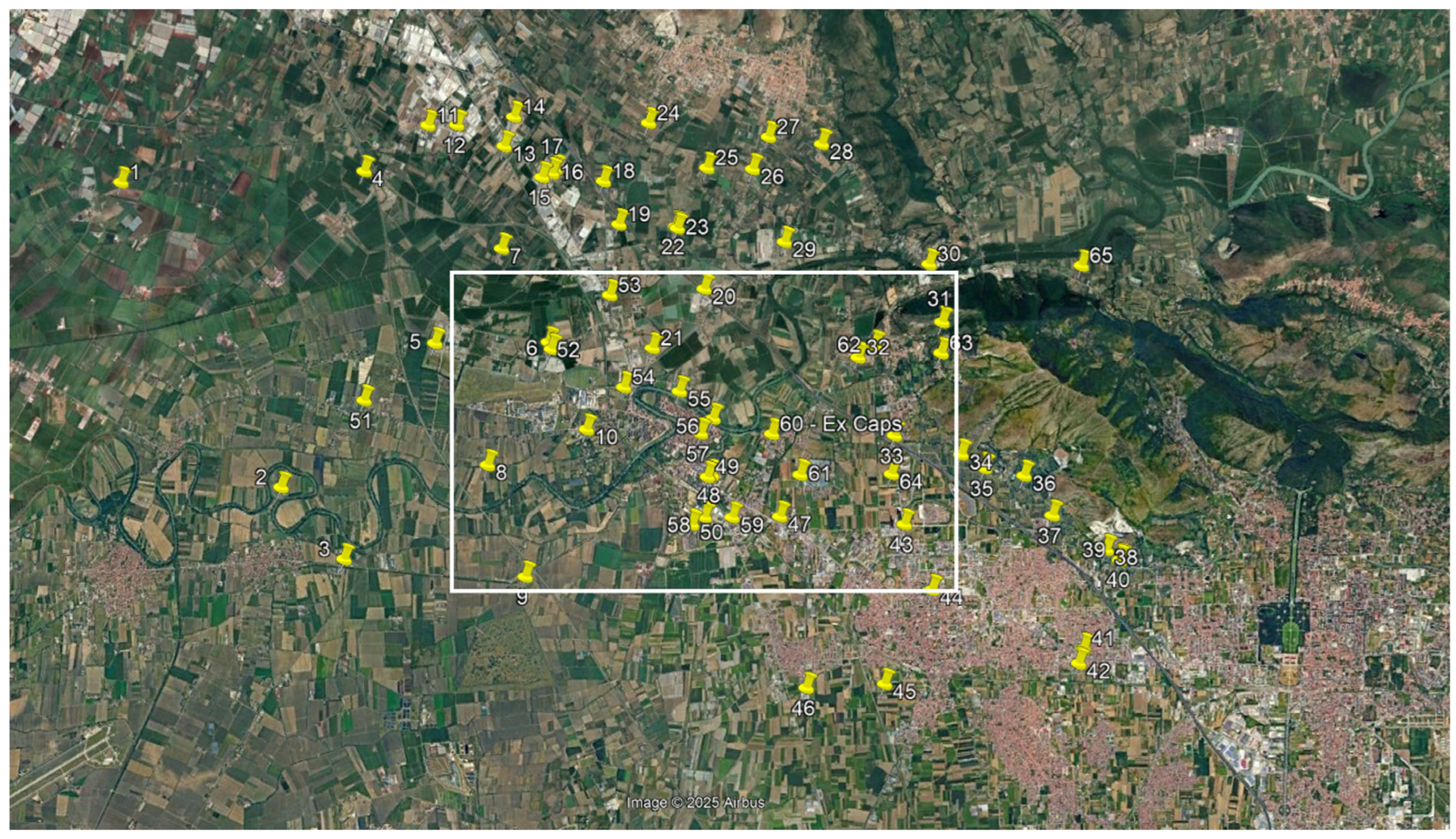
3.1. Morphostratigraphical Analysis

The stratigraphic setting of Capua and its surroundings has been derived from the collection and re-interpretation of sixty-five boreholes, whose depths range between 10 and 75 m (Figure 3). We selected eight of the sixty-five boreholes to derive a geological cross-section of the investigated area. This cross-section allowed us to define the areas where fine-grained alluvial sediments (i.e., clays and silts) are distributed and their spatial relation with volcanic units. Clay-rich areas include part of the Volturno River valley and some abandoned meanders. We selected these areas as the preferred sites to drill four new boreholes (named S2, S4, S5, and S6) with the aim of sampling clayey sediments for paleoenvironmental reconstruction. Borehole S5 was also projected on the geological cross-section. Coring was carried out with an MK200 probe, with 1-m-long rods and 76 mm diameter core barrels.

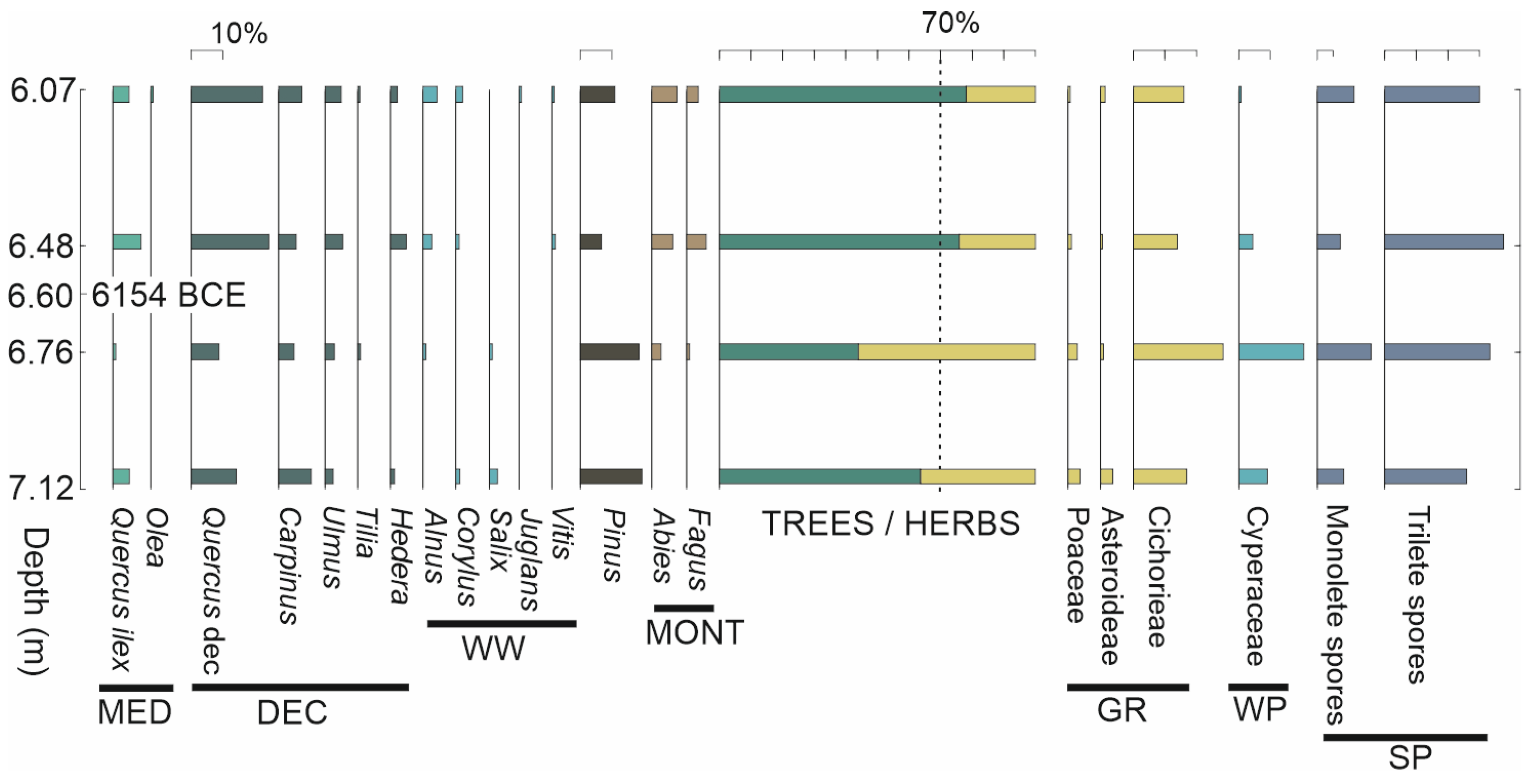
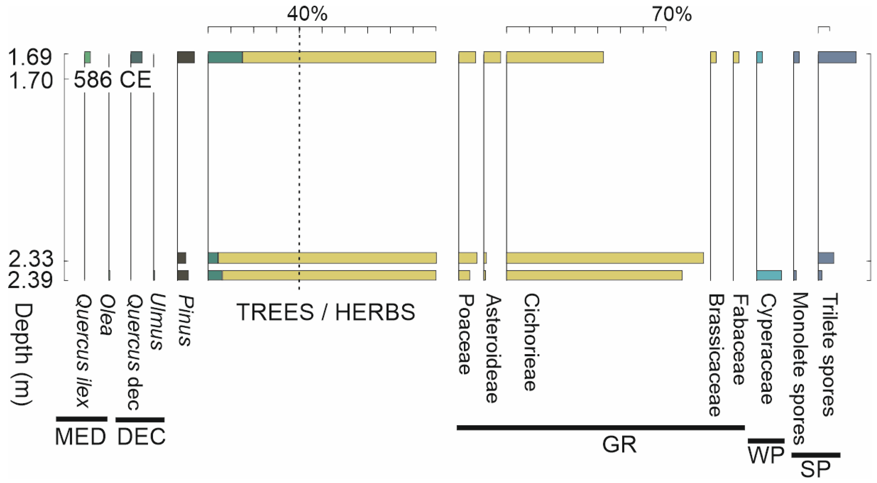
3.2. Palynological Analysis

In order to provide data related to the paleoenvironment and paleolandscape in the Capua area, cores S2, S4, S5, and S6 were sampled for palynological analysis. This is one of the most widely used methodologies to reconstruct ancient landscapes and to highlight the transformations they have undergone, either under the pressure of natural or cultural events (e.g., [19,33,34,35,36,37]). The application of this methodology to archeologically rich contexts may involve interpretative difficulties, but it can provide local data of great interest, allowing a deeper understanding of the complex relationships between humans and the environment (e.g., [37,38,39,40]). In such contexts, special attention is paid to the recognition of anthropogenic indicators, i.e., a series of plants or other elements that are directly related to anthropogenic activities and can therefore provide indications of land use (e.g., [41,42,43,44]).
The collected samples were treated in the laboratory using a chemical–physical method aimed at isolating the organic matter present in the sediment. The main steps consisted of attacks with hydrochloric and hydrofluoric acid to dissolve carbonates and silicates, followed by ultrasonic filtration and separation with heavy liquids to concentrate the organic matter in the residue. The latter is mounted with glycerin on slides for observation under an optical microscope at 500× and 1000× magnifications. The recognition and counting of pollen grains allows for quantitative data to be obtained, which is necessary for the preparation of pollen diagrams showing the percentages of the taxa recognized in the different samples.

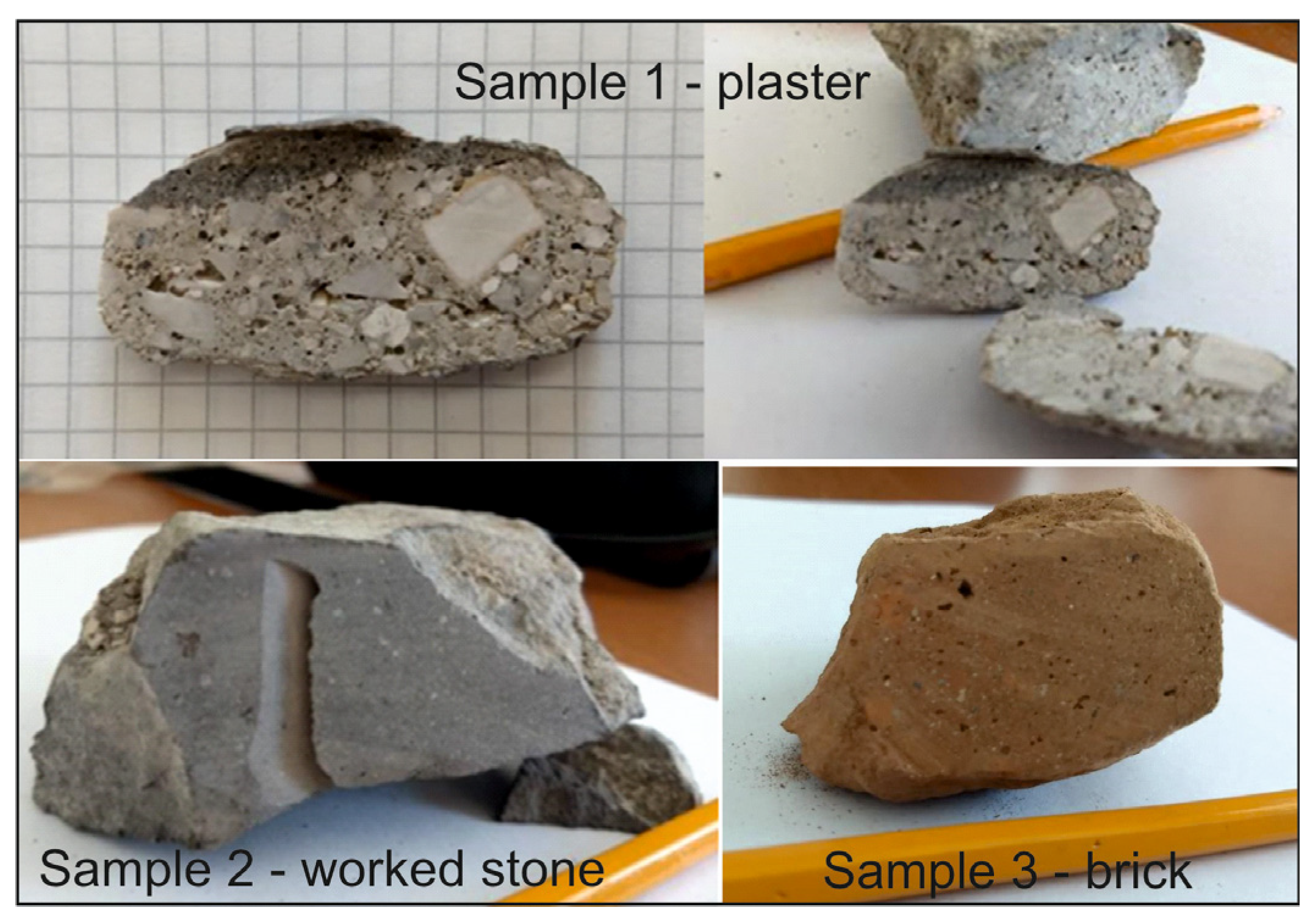
3.3. Archeometric Analysis

Three archeological artifacts were identified in core S4 (see Section 4.1) and subjected to archaeometric analysis. These analyses consist of the application of mineralogical, petrographical, and chemical methods, which allow us to obtain information from finds, artifacts, and the archeological context (e.g., stratigraphic excavations) for a more complete historical understanding of the object. These analyses can also contribute to the reconstruction of human behavior through the study of the traces of use on manufacts, to the definition of the ceramic, metallic, or glass artifacts’ compositions, to the study of the nature of the rocks used for lithic industries, to the reconstruction of the environment and ancient landscapes.
The composition of the materials can, in turn, provide information on the local or allogenic nature of artifacts, giving important indications on the possible routes of exchanges and trades. Finally, archaeometric analyses can give useful information to improve the conservation of a find and its restoration.
The three analyzed artifacts consist of a piece of mortar, a worked stone, and a brick, found in this sequence from top to bottom between 1.7 and 2 m in depth (Figure 4):
  • Sample 1—1.70 m depth—mortar-like material;
  • Sample 2—1.90 m depth—worked stone-like material;
  • Sample 3—2.00 m depth—brick-like material.
Petrographic and mineralogical characterization have been performed through Transmitted Light Optical Microscopy (OM) and X-Ray Powder Diffraction (XRPD) analyses.
Thin-section petrographic analysis was conducted using an OPTIKA B-600 microscope coupled with a ZEISS Axiocam 105 (Carl-Zeiss-Strasse, Oberkochen, Germany) to acquire digital images. This analysis is a well-established analytical technique used for the study of geomaterials as it can provide fundamental information such as compositional and textural characteristics, optical properties of the matrix, as well as the type and abundance of inclusions.
X-Ray Powder Diffraction (XRPD) was used for qualitative phase identification on representative powders. First, rock samples were crushed by hand by using an agate mortar. Powders were obtained through a micronizing mill using a Mc Crone apparatus (with agate cylinders) for 15 min in order to obtain a particle size < 5 μm, a condition that allows various problems to be overcome when acquiring the X-ray spectra (particle statistics, primary extinction, microabsorption, and preferential orientation phenomena). In total, 20% of α-Al2O3, 1 μm, (Buehler Micropolish) was added to the powders as a reference standard. The analysis was performed with a Panalytical X’Pert PRO PW 3040/60 automatic diffractometer with a X’Celerator RTMS detector and a MPD PW 3710 unit, equipped with X’Pert Data Collector 2.1 software for data acquisition and X’Pert Highscore Plus 3.04 for pattern interpretation. The following operating conditions were used:
-
CuKα radiation, 40 kV, and 40 mA;
-
2θ interval from (analytical range of) 4 to 50° and step size equal to 0.020° 2θ;
-
counting time equal to 120 s time per step.

3.4. Radiocarbon Analysis

Two radiocarbon datings were performed to clarify the chronology of the samples that provided palynological results. Radiocarbon dating was performed by accelerator mass spectrometry (AMS) at the PoLaR-CIRCE, DMF, University of Campania “Luigi Vanvitelli”.
Samples collected at depths of 1.70 m in core S2 and 6.60 m in core S4 (see Section 4.1) underwent chemical pretreatment according to the laboratory pretreatment procedures [45]. Radiocarbon dating was performed on the bulk organic matter dispersed within the dark-colored sediment. In detail, the samples underwent a carbonate removal procedure involving a 24-h acid attack in a 6% HCl solution (v/v) to completely remove potential carbonate interferences, ensuring that the measurement pertains solely to the soil organic matter fraction. An adequate amount of decarbonated soil (sufficient to guarantee at least 1 mg of C) was combusted and graphitized according to the Sealed Quartz Tube Combustion and graphitization methods [46].
(i)
Sample is weighed into quartz tubes (outer diameter of 6 mm and inner diameter of 4 mm) with a sufficient amount of CuO rods (approximately 30 mg) to ensure the complete combustion of the produced soil organic carbon; ii) the quartz tube is attached by Swagelock Utratorr fittings to a high-vacuum line (i.e., <10−6 mbar), evacuated to avoid possible contamination, and sealed with an oxypropane torch capable of reaching 1300 °C. The sealed tube containing the sample and CuO is placed on a grid in a muffle furnace at 920 °C for 6.5 h.
(ii)
Among the combustion products (e.g., CO2, H2O, NO2, SO2), only CO2, which preserves the chronological information of the sample, is isolated using a cryogenic line trapping H2O and CO2 in selective cryogenic traps and allowing the removal of other gases (non-condensable) through a pumping system.
(iii)
Isolated CO2 undergoes a final transformation (reduction to graphite) before measurement. Specifically, purified CO2 is transferred into 9 mm Pyrex tubes containing a mixture of reagents (Zn (37.5 mg) and TiH2 (11 mg)) that will reduce the CO2 to graphite and a 6 mm tube containing 3 mg of Fe powder, which acts as a catalyst for the reaction. The sample then undergoes the Sealed Tube Zinc Reduction reaction at 560 °C for 8 h.
(iv)
Produced graphite is finally pressed together with Fe powder into aluminum cathodes and mounted in a carousel of 40 samples, along with a series of blank and reference samples (with known 14C content) for measurement with the CIRCE AMS system [47]. The measured isotopic ratios are converted into radiocarbon ages [48] and calibrated using Oxcal 4.4 [49] and the INTCAL22 [50] calibration dataset. For each sample, results are reported as calendric age intervals at 1 and 2 sigma.

4. Results

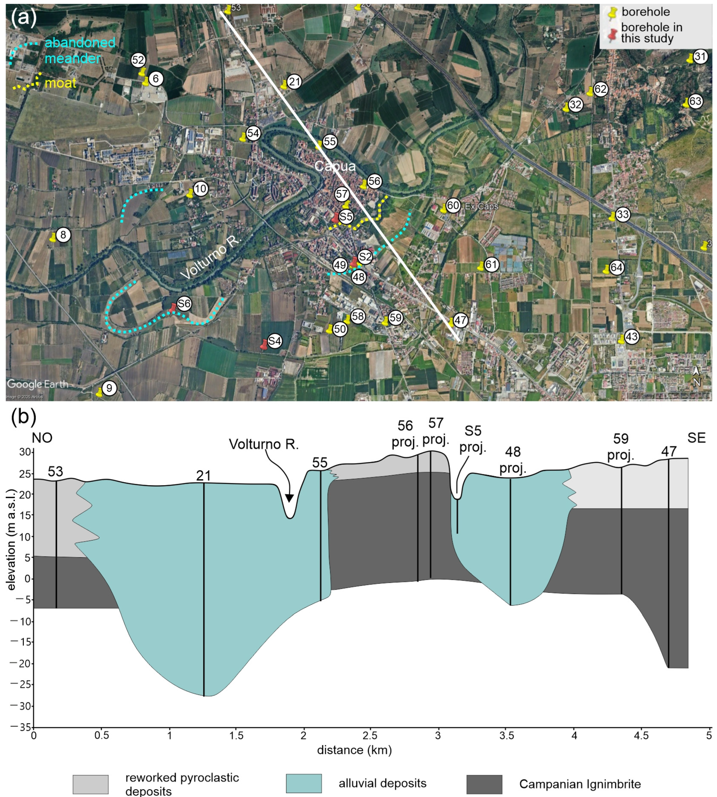
4.1. Morphostratigraphical Setting of the Capua Territory
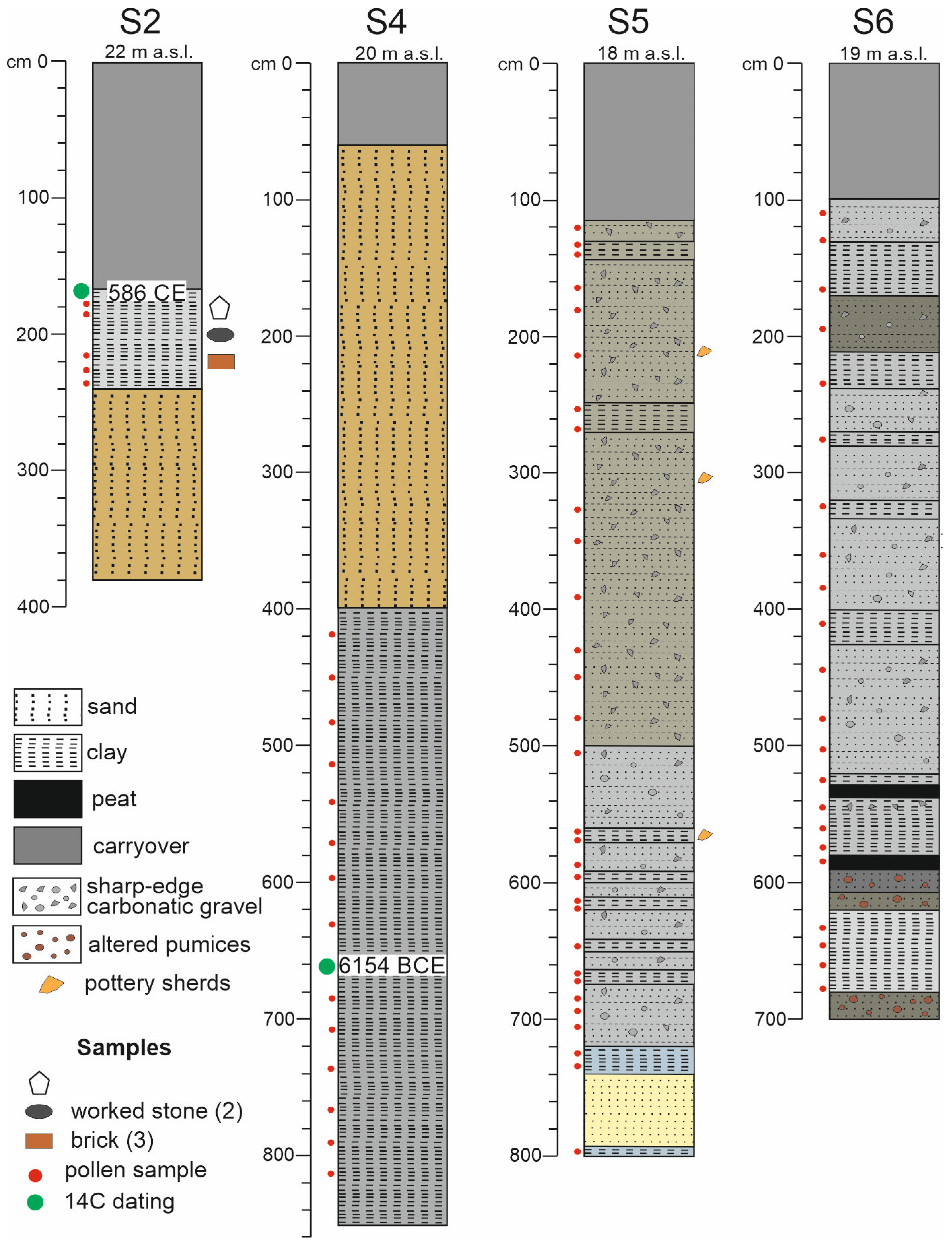
A geological cross-section was constructed to characterize the stratigraphic framework of the subsurface around the city of Capua and, therefore, define the lateral–vertical relationships between the different lithological units identified (Figure 5a,b).
The section is oriented northwest/southeast and intersects boreholes 53, 21, 55, 56, 57, 48, 59, and 47. The borehole S5 realized within this study has also been projected in the cross-section (Figure 5a,b). Three main units have been recognized: alluvial deposits (cyan in Figure 5b), reworked volcanoclastic deposits (light gray in Figure 5b), and the Campanian Ignimbrite (dark gray in Figure 5b).
Alluvial deposits consist of gravels and sandy gravels with an abundant clay fraction, sometimes containing plant remains and peat layers. These deposits are found around the current bed of the Volturno River and to the east of the city of Capua. Specifically, the alluvial deposits east of Capua are likely interpretable as a paleo-channel of the Volturno River, as confirmed by the geomorphological analysis of Google Earth orthophotos, which show the presence of an abandoned meander in this area.
The volcanoclastic deposits consist of sand with abundant pumice resting on top of the Campanian Ignimbrite and passing laterally to the alluvial deposits. The Campanian Ignimbrite is described as a gray to black, dense, tuffaceous ash, which in some areas takes on the appearance of a tuffite. These are mainly found near the present-day urban center of Capua and influence the area’s morphology, with the urban area of Capua appearing elevated relative to the alluvial plain of the Volturno River (Figure 5b). It can be hypothesized that this particular geomorphological configuration influenced the settlement dynamics of ancient Capua, as its elevated position compared to the surrounding alluvial plain provided natural protection from potential river flooding.
The geological cross-section and the recognition of the abandoned meanders of the Volturno River allowed for the identification of the areas to locate four new boreholes (named S2, S4, S5, and S6 in Figure 5a). All boreholes intercept a carryover level whose thickness ranges from 0.6 m in borehole S4 to 1.7 m in borehole S2 (Figure 6).
Borehole S2 has been placed in correspondence with an abandoned meander of the Volturno River and is 3.8 m long. It intercepts at the level of archeological finds at depths between 1.7 and 2.4 m. These finds have been sampled for archaeometric analysis and are in a clayey matrix. The clay matrix has been sampled for pollen analysis and for radiocarbon dating (sample at a depth of 1.7 m) to constrain the age of the archeological finds. This level rests on reworked brownish pyroclastics (Figure 6).
Borehole S4 has been placed in the alluvial plain of the Volturno River, about 1.3 km to the southeast of borehole S2. It intercepts a 3.4 m thick layer of brownish reworked pyroclastic deposits resting on a 4.4 m thick layer consisting of grayish clays. A sample at a depth of 6.6 m has been collected for radiocarbon dating, whereas several clayey samples for pollen analysis have been collected at various depths (Figure 6).
Borehole S5 was placed in the moat bordering the town of Capua. It is 8 m long and intercepts an alluvial sequence consisting of alternating layers of fine-grained sediments (clayey and silts) with the presence of reworked and altered pumices and a sandy fraction. Several samples for pollen analysis have been collected at various depths (Figure 6).
Borehole S6 has been placed in an abandoned meander of the Volturno River placed about three kilometers to the southeast of Capua. The borehole is 7 m long and intercepts an alluvial sequence consisting of alternating layers of clays and silts that have been sampled for palynological analysis. Two peat layers have been found at the base of this borehole (Figure 6).

4.2. Chronology

The results of the 14C measurements, calibrated to calendar ages, are shown in Figure 7 and Table 1. The analyzed samples yielded the following calendar age ranges: 6219–6080 BCE (1 sigma) and 6231–6066 BCE (2 sigma) for the sample in borehole S4 (DSH10420) and 559–604 CE (1 sigma) and 546–640 CE (2 sigma) for the sample in borehole S2 (median 586 CE).
Although the data pertain to only two samples, they do not allow for a detailed reconstruction of the area’s chronology. However, the results are fully consistent with the stratigraphy of the conducted surveys, confirming the coverage of a broad chronological interval that is potentially analyzable.

4.3. Landscape and Land Use
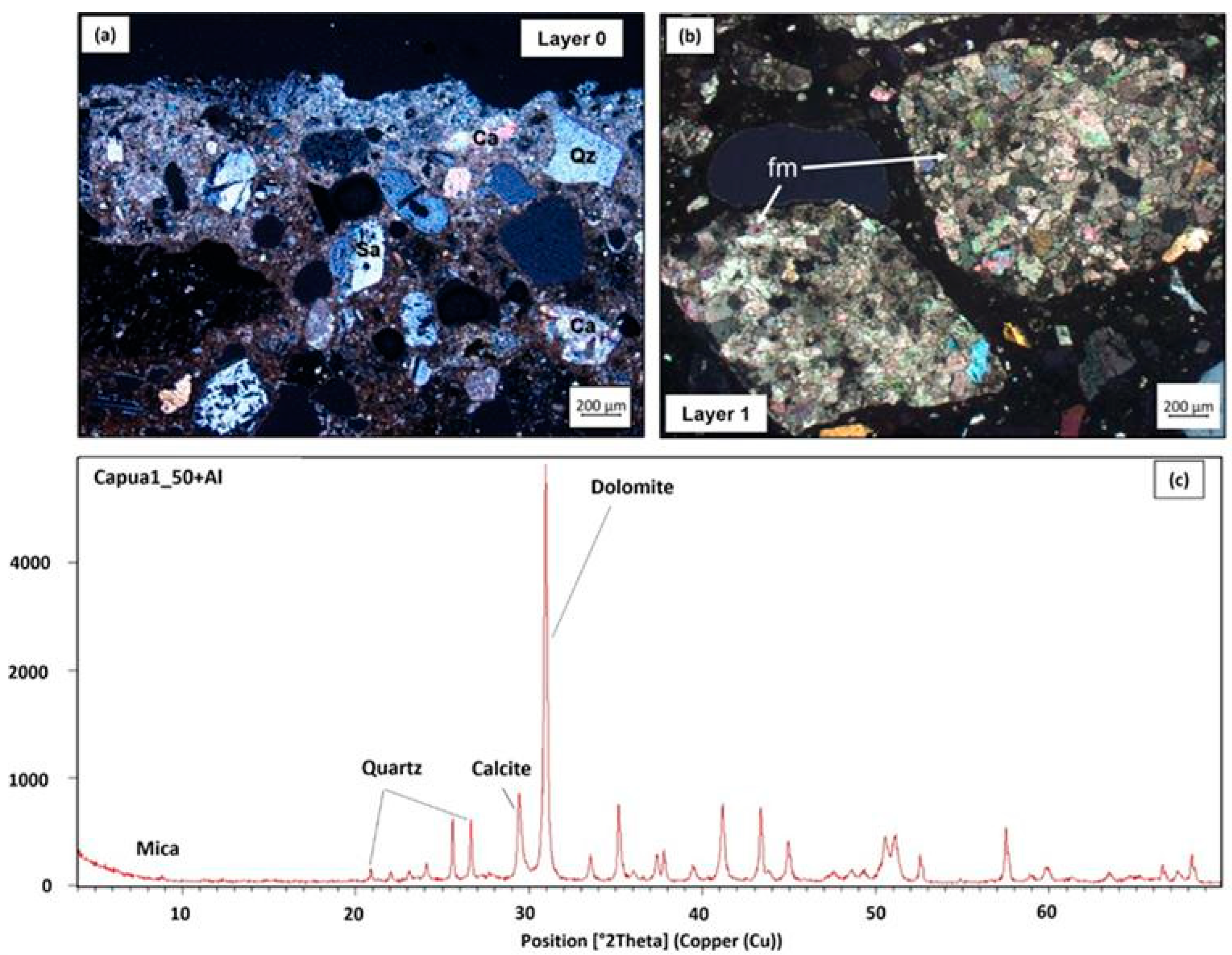
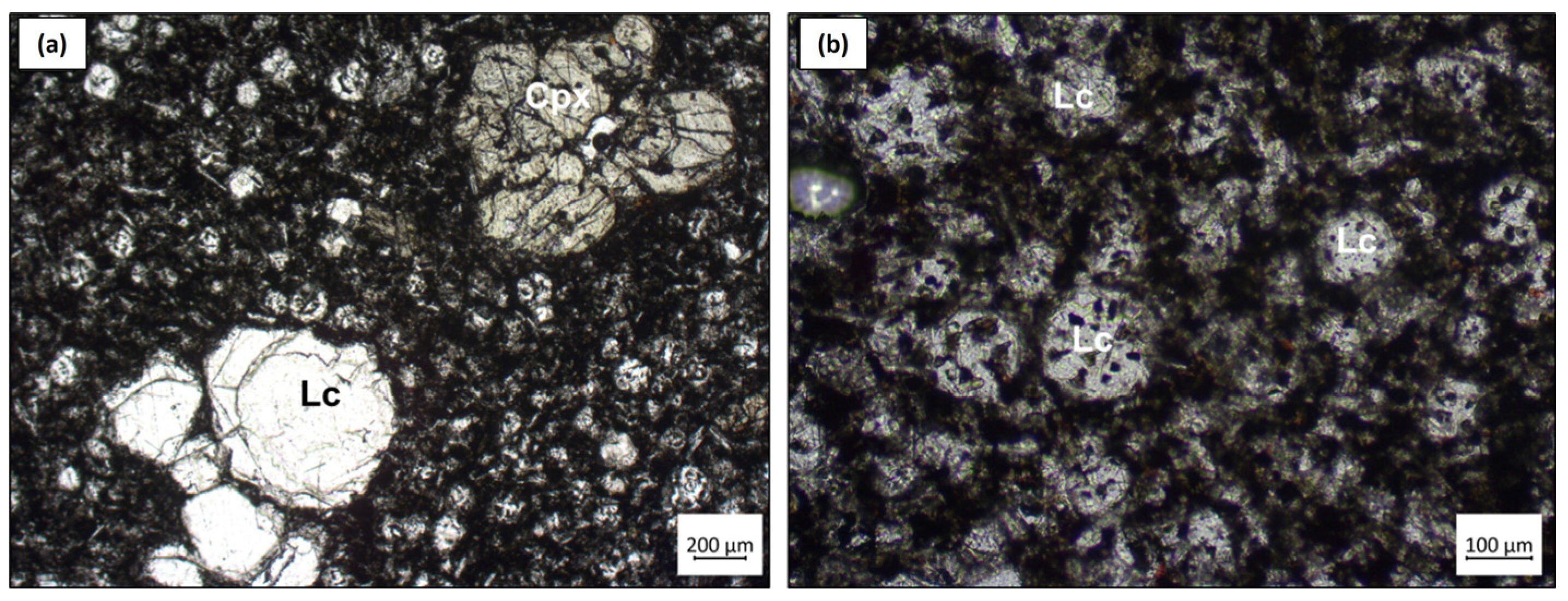
Among the samples taken and processed for palynological analysis, only three samples from core S2 and four from core S4 provided significant data that allowed the construction of pollen diagrams (Figure 8 and Figure 9). Although the nature of the sampled levels in all cores seemed suitable for pollen conservation, all the other samples proved barren.
The levels analyzed in core S4, given their depth and lithological nature (very compact clay), certainly represent an older period than the more superficial levels analyzed in core S2. Trees dominate the vegetation association in the S4 core samples, as indicated by the tree percentages close to 70% (Figure 8), thus giving the image of a forested landscape, with different types of associations, from Mediterranean to deciduous forest and from riparian to mountain forest. In the sample at 6.76 m, the lower percentage of trees is due to an increase in Cyperaceae, likely a sign of a local increase in moisture. The absence of anthropogenic indicators in the pollen spectra confirms that the sediments analyzed represent an ancient period when no anthropogenic activities were yet present in this area.
The diagram of core S2 (Figure 9), whose sampled levels certainly fall in the historical period, is close to the findings of archeological artifacts (Figure 6) dated to the Middle Ages and shows a completely different vegetation association from that indicated by core S4. In the three analyzed samples, there is a dominance of grasses, and specifically of Cichorieae, which reflects the image of a very open landscape, where forested areas are extremely reduced and probably far from the sampling site, as indicated by the percentages of trees being less than 20%. The Cichorieae are part of the anthropogenic indicator group and, in particular, suggest the presence of pastures.

4.4. Archeometry

Optical microscopic analysis performed on sample 1 allows us to establish that the mortar is stratified. Layer 0 (Figure 10a), which is supposed to be the external one, shows a binding fraction with a carbonatic matrix. XRPD analysis (Figure 10c) highlighted that the binder is predominantly dolomitic. OM also showed that the aggregate has a small size (mm), and its nature is both volcanic and carbonatic (probably a sand), being characterized by fragments of sanidine, calcite, clinopyroxene, and quartz crystals.
In Layer 1 (Figure 10b), the binding fraction is carbonatic (dolomitic); aggregate is coarser (cm) with respect to Layer 0 and is characterized mainly by carbonatic fragments and fragments deriving from the firing of marble. The presence of marble fragments suggests a recycling of preexisting materials [51,52]. Moreover, volcanic fragments are rare.
The mineralogical analyses of sample 1 highlighted the presence of dolomite as the main component of the material but also the presence of calcite, quartz, and mica as subordinate mineralogical phases; traces of plagioclase and sanidine are also evident (Figure 10c). Therefore, the mortar appears to have a dolomitic binder, with the addition of aggregates of both carbonatic and volcanic origin, as highlighted also by OM analysis.
The rock sample 2 has a strongly porphyritic inequigranular texture, with a glassy groundmass. Among the phenocrysts, leucite is the most abundant mineralogical phase, followed by clinopyroxene (Figure 11a,b). Leucite crystals are mostly euhedral and often skeletal, with the so-called “wagon wheel” shape. There are two distinct differently sized leucite populations: the first one comprises small crystals (around 1 mm) and the second comprises crystals of larger size (around 7 mm). Leucite-bearing rocks can be found in a few alkaline volcanic world environments, such as the Roman Comagmatic Province [53].
Given its thickness in the core, sample 3 is likely to be a building brick. The matrix shows inactive optical activity, with a variable grain size and type of aggregate. Inclusions consist of pumice, scoriae, and fragments of crystals such as quartz, sanidine, clinopyroxene, and plagioclase (Figure 12a,b). The presence of recarbonation is evident in the pores, suggesting the use of a clayey CaO-rich raw material [54].
XRPD analyses confirmed OM observations (Figure 12c). The main mineralogical phase is quartz, followed by calcite, hematite, plagioclase, sanidine, and mica.

5. Discussion

The multidisciplinary approach adopted in this work has proven to be a valuable tool, albeit preliminary, for achieving the set objectives, namely the reconstruction of the natural landscape and its changes due to human activity during the transition to the medieval period.
Similarly to the model proposed for Padua [13], the Volturno River plays a significant role in the planning of the medieval urban layout: this is also consistent with what has been observed using archeological methodologies in the neighboring territory, where the presence of paleo-channels [17] appears to influence the forms of land use between antiquity and the medieval period. Furthermore, the observation—at least in the sectors investigated—of a dynamic of progressive growth of deposits, which correspond to the current layers of habitation and recall similar cases of Campanian cities located near riverbeds (e.g., Benevento [14]), opens up significant prospects for archeological research.
The geomorphological and stratigraphic analysis has allowed for a clarification of the lithological nature of the subsoil, as well as the geomorphological setting that influenced settlement dynamics. In particular, the geological section in Figure 5 shows that the city of Capua stands on a high gray tuff plateau carved in the Campanian Ignimbrite, bordered by a bend of the Volturno River. The position of Capua, elevated above the Volturno floodplain, reduced the risk of river flooding, ensuring its continued settlement.
Pollen analysis revealed two different moments in the history of this area. The results obtained from the S4 core are indicative of an older time, as confirmed by radiocarbon dating, which gives an age of about 8000 yr cal BP at a depth of 6.60 m. At that time, the plain around Capua was occupied by forests in which no clear signs of human activities can be recognized. The presence of a walnut grain and a few vine grains is in fact associated with the presence of the wet woodland, which is the natural environment of the wild varieties of these elements [55].
The S2 core, on the other hand, returned the image of a completely different landscape of the Early Middle Ages (late 5th to 10th century), as suggested by the archeological finds from the core drilling and confirmed by radiocarbon dating (586 CE at 1.70 m depth). The dominance of Cichorieae indicates that the plain around Capua was dominated by grasses, probably pastures [56] and cultivated fields, but the scarcity or absence of other significant anthropogenic indicators, such as coprophilous fungi, Brassicaceae, and Cereals, does not allow for a more detailed paleoenvironmental reconstruction.
No pollen data are available in the Volturno River Plain for comparison. Some data come from the coastal sector of the Garigliano Plain [40] while the most useful pollen data come from a marine core collected in the Gulf of Gaeta, ca. 20 km off the Volturno mouth [18]. These data provide a regional image of vegetation from the entire Volturno River catchment and indicate that forests dominated the alluvial and coastal plains during much of the Holocene, confirming what emerged from the analysis of the S4 core. Forest reduction began during the Roman times [18], when land reclamation works made the soils more suitable for human exploitation (cultivation and pasture). But the greatest changes to the landscape, with widespread regional deforestation, intensive cultivation, and livestock farming, occurred from the Late Antique–Medieval period onwards, as our data from the S2 core seem to confirm.
The archaeometric analysis, carried out on the finds of the S2 coring, indicates that both the mortar and the brick show clear indications of poor care in preparation and firing, an element that might suggest post-antique manufacturing activities of the medieval period, which were characterized by less refinement than the ancient period [51,55]. The relatively recent chronology was after all confirmed by the dating of the sample at 1.70 m, which provided an age of 1365 years from the present (586 CE).

6. Conclusions

The work presented here, although preliminary, clearly demonstrates how the multidisciplinary approach is the only feasible one to address the issues related to the complex human–environment interactions in a territory like Capua, which has a long history of human settlement. The results obtained suggest continuing the investigation in order to fill the temporal gaps that have emerged and, in particular, to identify and analyze the transitional period between the natural and anthropized landscape. Despite the extensive palynological sampling of the four new cores, most of the samples proved barren. A new coring campaign will be carried out in selected areas around the city of Capua, with the aim of obtaining further sediment sequences to be analyzed both chronostratigraphically and palynologically.
Among the main results, the morphostratigraphic analysis highlighted the elevated position of Capua with respect to the Volturno floodplain that favored the protection of the town from alluvial events. Interesting data have also been obtained from the analysis of core S2. Here, pollen and archaeometric analyses reconstruct an early medieval context, the age of which is confirmed by radiocarbon dating. Both data indicate a heavy exploitation of resources, testifying to a lack of care in territorial management and in the production of artifacts. An open landscape surrounded an archeological site represented by a possible building whose function remains uncertain. Future research will also focus on clarifying the significance of this unknown archeological evidence.

Author Contributions

Conceptualization, E.R.E., N.B. and E.V.; methodology, E.R.E., C.R., F.M. and E.V.; investigation, E.R.E., C.R., F.M. and E.V.; writing—original draft preparation, E.R.E., C.R., F.M., N.B. and E.V.; writing—review and editing, E.R.E. and E.V.; supervision, E.R.E. and E.V.; funding acquisition, N.B. All authors have read and agreed to the published version of the manuscript.

Funding

This research was funded by University of Vanvitelli, V:ALERE Program 2019 (€ 17,679,927.70). The project funded is MeditContactCult (PI, Fernando Gilotta—SH-2/408; € 180,000) https://www.letterebeniculturali.unicampania.it/mediterraneum (accessed on 1 February 2020).

Data Availability Statement

The raw data supporting the conclusions of this article will be made available by the authors on request.

Acknowledgments

We wish to thank the Superintendence of Archaeology, Fine Arts and Landscapes for the Province of Caserta and Benevento (Mario Pagano and Antonella Tomeo) for granting us permission to carry on the borehole campaign and to study the archaeological artifacts found in borehole S2. We thank the municipality of Capua and the mayor Adolfo Villani for providing administrative authorization for the borehole campaign. Three anonymous Reviewers and the Academic Editor are thanked for their fruitful suggestions that highly increased the quality of our original manuscript.

Conflicts of Interest

The authors declare no conflicts of interest.

References

  1. Cornell, T.J. The Beginnings of Rome; Routledge: London, UK, 1995. [Google Scholar]
  2. DeLacey, L. Capua: Roman, Early Christian and Medieval Archaeology; J. Paul Getty Museum: Los Angeles, CA, USA, 2003. [Google Scholar]
  3. Durrant, H.F.P. The History of the Norman Kingdom of Sicily; Oxford University Press: Oxford, UK, 1961. [Google Scholar]
  4. Di Resta, I. Capua Medievale. La Città dal IX al XIII Secolo e L’architettura dell’età Longobarda; Liguori Editore: Napoli, Italy, 1983. [Google Scholar]
  5. Pane, G.; Filangieri, A. Capua. Architettura e arte: Catalogo Delle Opere; Edizioni Capuanuova: Vitulazio, Italy, 1994; Volumes 1–2. [Google Scholar]
  6. Peduto, P. Quanto rimane di Salerno e di Capua longobarde (secc. VIII–IX). In I Longobardi del Sud; Giorgio Bretschneider Editore: Roma, Italy, 2010; pp. 257–278. [Google Scholar]
  7. Brogiolo, G.P. Le Origini Della Città Medievale; Società Archeologica: Mantova, Italy, 2011. [Google Scholar]
  8. Brogiolo, G.P.; Gelichi, S. La Città Nell’alto Medioevo Italiano. Archeologia e Storia, 9th ed.; Laterza: Roma, Italy, 2012. [Google Scholar]
  9. Augenti, A. Archeologia Della Città Medievale. 2014; pp. 173–182. Available online: https://www.torrossa.com/en/resources/an/3015868 (accessed on 20 March 2025).
  10. Gelichi, S. Archeologia urbana e storia della città altomedievale: Quale futuro. In Dalla Valdelsa al Conero. Ricerche di Archeologia e Topografia in Ricordo di Giuliano de Marinis; Baldini, G., Giroldini, P., Eds.; Edizioni All’Insegna del Giglio: Firenze, Italy, 2016; pp. 163–168. [Google Scholar]
  11. Di Luzio, E.; Carfora, P. Approcci Multidisciplinari per la Ricostruzione del Paesaggio di Una Grande Strada Romana. La via Appia al Valico Degli Aurunci; Claudio Grenzi Editore: Foggia, Italy, 2019. [Google Scholar]
  12. Corrado, G.; Amodio, S.; Aucelli, P.P.C.; Pappone, G.; Schiattarella, M. The Subsurface Geology and Landscape Evolution of the Volturno Coastal Plain, Italy: Interplay between Tectonics and Sea-Level Changes during the Quaternary. Water 2020, 12, 3386. [Google Scholar] [CrossRef]
  13. Mozzi, P.; Ferrarese, F.; Zangrando, D.; Gamba, M.; Vigoni, A.; Sainati, C.; Fontana, A.; Ninfo, A.; Piovan, S.; Rossato, S.; et al. The modeling of archaeological and geomorphic surfaces in a multistratified urban site in Padua, Italy. Geoarchaeology 2017, 33, 67–84. [Google Scholar] [CrossRef]
  14. Amato, V.; Ciarcia, S.; Rossi, A.; Santoriello, A. The urban geoarchaeology of Benevento, Southern Italy: Evaluating archaeological potential. Geoarchaeology 2017, 33, 100–111. [Google Scholar] [CrossRef]
  15. Pagano, M.; Tomeo, A. Capua. La Seconda Roma; Edizioni Belle Epoque: Napoli, Italy, 2021. [Google Scholar]
  16. Quilici Gigli, S. La via Appia nella Campania settentrionale. Apporti dalle immagini aeree e satellitari. Archeol. Aerea 2020, 14, 83–92. [Google Scholar]
  17. Quilici Gigli, S. La Via Appia nella Campania settentrionale, suoi principali allacciamenti e diramazioni. Orizzonti Rass. Di Archeol. 2022, 23, 193–205. [Google Scholar]
  18. Di Rita, F.; Lirer, F.; Bonomo, S.; Cascella, A.; Ferraro, L.; Florindo, F.; Insinga, D.D.; Lurcock, P.C.; Margaritelli, G.; Petrosino, P.; et al. Late Holocene forest dynamics in the Gulf of Gaeta (central Mediterranean) in relation to NAO variability and human impact. Quat. Sci. Rev. 2018, 179, 137–152. [Google Scholar] [CrossRef]
  19. Di Lorenzo, H.; Di Donato, V.; Molisso, F.; Lubritto, C.; Russo Ermolli, E. A high-resolution record of landscape changes and land use over the last 5000 years in western Calabria (S. Eufemia Gulf, southern Tyrrhenian Sea, Italy). Holocene 2021, 33, 1045–1059. [Google Scholar] [CrossRef]
  20. Sadori, L. The Lateglacial and Holocene vegetation and climate history of Lago di Mezzano (central Italy). Quat. Sci. Rev. 2018, 202, 30–44. [Google Scholar] [CrossRef]
  21. Santangelo, N.; Romano, P.; Ascione, A.; Russo Ermolli, E. Quaternary evolution of the Southern Apennines coastal plains: A review. Geol. Carpath. 2017, 68, 43–56. [Google Scholar] [CrossRef]
  22. Cinque, A.; Patacca, E.; Scandone, P.; Tozzi, M. Quaternary kinematic evolution of the Southern Apennines. Relationships between surface geological features and deep lithospheric structures. Ann. Geophys.-Italy 1993, 36, 249–259. [Google Scholar]
  23. Turco, E.; Macchiavelli, C.; Mazzoli, S.; Schettino, A.; Pierantoni, P.P. Kinematic evolution of Alpine Corsica in the framework of Mediterranean mountain belts. Tectonophysics 2012, 579, 193–206. [Google Scholar] [CrossRef]
  24. Patacca, E.; Scandone, P. Geology of the Southern Apennines. Ital. J. Geosci. 2007, 7, 75–119. [Google Scholar]
  25. Jolivet, L.; Faccenna, C. Mediterranean extension and the Africa-Eurasia collision. Tectonics 2000, 19, 1095–1106. [Google Scholar] [CrossRef]
  26. Turco, E.; Schettino, A.; Pierantoni, P.P.; Santarelli, G. Chapter 2 The Pleistocene extension of the Campania Plain in the framework of the southern Tyrrhenian tectonic evolution: Morphotectonic analysis, kinematic model and implications for volcanism. In Developments in Volcanology; De Vivo, B., Ed.; Elsevier: Amsterdam, The Netherlands, 2006; Volume 9, pp. 27–51. [Google Scholar] [CrossRef]
  27. Brocchini, D.; Principe, C.; Castradori, D.; Laurenzi, M.A.; Gorla, L. Quaternary evolution of the southern sector of the Campania Plain and early Somma-Vesuvius activity: Insights from the Trecase 1 well. Miner. Petrol. 2001, 73, 67–91. [Google Scholar] [CrossRef]
  28. Amato, V.; Aucelli, P.P.C.; Bellucci Sessa, E.; Cesarano, M.; Incontri, P.; Pappone, G.; Valente, E.; Vilardo, G. Multidisciplinary approach for fault detection: Integration of PS-InSAR, geomorphological, stratigraphic and structural data in the Venafro intermontane basin (Central-Southern Apennines, Italy). Geomorphology 2017, 283, 80–101. [Google Scholar] [CrossRef]
  29. Giano, S.I.; Gioia, D.; Schiattarella, M. Morphotectonic evolution of connected intermontane basins from the southern Apennines, Italy: The legacy of the pre-existing structurally controlled landscape. Rend. Fis. Acc. Lincei 2014, 25, 241–252. [Google Scholar] [CrossRef]
  30. Giaccio, B.; Hajdas, I.; Isaia, R.; Deino, A.; Nomade, S. High-precision 14C and 40Ar/39Ar dating of the Campanian Ignimbrite (Y-5) reconciles the time-scales of climatic-cultural processes at 40 ka. Sci. Rep. 2017, 7, 45940. [Google Scholar] [CrossRef]
  31. Totaro, F.; Petrosino, P.; Valente, E.; Arienzo, I.; D’Antonio, M.; Di Vito, M.; Giaccio, B.; Jicha, B.J.; Petrelli, M.; Santangelo, N.; et al. Last interglacial paleoshoreline location and tectono-stratigraphic evolution of the peri-Tyrrhenian Sarno basin, southern Italy, constrained by tephrostratigraphy. Earth Surf. Process. Landoforms 2025, 50, 6039. [Google Scholar] [CrossRef]
  32. Cusano, A.; Lo Curzio, S.; Magliulo, P.; Russo, F.; Valente, E. Geomorphological changes and land-use variations of the Lower Volturno River (Southern Italy) by Cartography and Remote sensing imagery: Preliminary results. Rend. Online Soc. Geol. It. 2023, 61, 70–76. [Google Scholar] [CrossRef]
  33. Mercuri, A.M.; Sadori, L.; Blasi, C. Archaeobotany for cultural landscape and human impact reconstructions. Plant Biosyst. 2010, 144, 860–864. [Google Scholar] [CrossRef]
  34. Sadori, L.; Jahns, S.; Peyron, O. Mid-Holocene vegetation history of the central Mediterranean. Holocene 2011, 21, 117–129. [Google Scholar] [CrossRef]
  35. Mercuri, A.M. Genesis and evolution of the cultural landscape in central Mediterranean: The ‘where, when and how’ through the palynological approach. Land. Ecol. 2014, 29, 1799–1810. [Google Scholar] [CrossRef]
  36. Mensing, S.A.; Tunno, I.; Sagnotti, L.; Florindo, F.; Noble, P.; Archer, C.; Zimmerman, S.; Pavón-Carrasco, F.J.; Cifani, G.; Passigli, S.; et al. 2700 years of Mediterranean environmental change in central Italy: A synthesis of sedimentary and cultural records to interpret past impacts of climate on society. Quat. Sci. Rev. 2015, 116, 72–94. [Google Scholar] [CrossRef]
  37. Russo Ermolli, E.; Di Lorenzo, H.; Santangelo, N.; Santo, A.; Comegna, C.; Petrosino, P. Unravelling 6000 years of interplay among environmental changes, anthropogenic activities, and Vesuvius eruptions in the upper Sarno Plain (Campania, Italy). Quat. Res. 2024, 1–22. [Google Scholar] [CrossRef]
  38. Mercuri, A.M.; Bandini, M.M.; Florenzano, A.; Montecchi, M.C.; Rattighieri, E.; Torri, P. Anthropogenic Pollen Indicators (API) from archaeological sites as local evidence of human-induced environments in the Italian Peninsula. Ann. Bot. 2013, 3, 143–153. [Google Scholar] [CrossRef]
  39. Florenzano, A. The History of Pastoral Activities in S Italy Inferred from Palynology: A Long-Term Perspective to Support Biodiversity Awareness. Sustainability 2019, 11, 404. [Google Scholar] [CrossRef]
  40. Di Lorenzo, H.; Aucelli, P.; Corrado, G.; De Iorio, M.; Schiattarella, M.; Russo Ermolli, E. Environmental evolution and anthropogenic forcing in the Garigliano coastal plain (Italy) during the Holocene. Holocene 2021, 31, 1089–1099. [Google Scholar] [CrossRef]
  41. Mazier, F.; Galop, D.; Gaillard, M.J.; Rendu, C.; Cugny, C.; Legaz, A.; Peyron, O.; Buttler, A. Multidisciplinary approach to reconstruct pastoral activities. An example from the Pyrenean Mountains (Pays Basque). Holocene 2009, 19, 171–178. [Google Scholar] [CrossRef]
  42. Brun, C. Anthropogenic indicators in pollen diagrams in eastern France: A critical review. Veg. Hist. Archaeobot. 2011, 20, 135–142. [Google Scholar] [CrossRef]
  43. Ejarque, A.; Miras, Y.; Riera, S. Pollen and Non-Pollen palynomorph indicators of vegetation and highland grazing activities obtained from modern surface and dung datasets in the eastern Pyrenees. Rev. Palaeobot. Palynol. 2011, 167, 123–139. [Google Scholar] [CrossRef]
  44. Deza-Araujo, M.; Morales-Molino, C.; Tinner, W.; Henne, P.D.; Heitz, C.; Pezzatti, G.B.; Hafner, A.; Conedera, M.A. Critical assessment of human-impact indices based on anthropogenic pollen indicators. Quat. Sci. Rev. 2020, 236, 106291. [Google Scholar] [CrossRef]
  45. Passariello, I.; Marzaioli, F.; Lubritto, C.; Rubino, M.; D’Onofrio, A.; de Cesare, N.; Borriello, G.; Casa, G.; Palmieri, A.; Rogalla, D.; et al. Radiocarbon sam-ple preparation at the CIRCE AMS laboratory in Caserta, Italy. Radiocarbon 2007, 49, 225–232. [Google Scholar] [CrossRef]
  46. Marzaioli, F.; Borriello, G.; Passariello, I.; Lubritto, C.; de Cesare, N.; D’Onofrio, A.; Terrasi, F. Zinc reduction as an alternative method for AMS radiocarbon dating: Process optimization at CIRCE. Radiocarbon 2008, 50, 139–149. [Google Scholar] [CrossRef]
  47. Terrasi, F.; De Cesare, N.; D’Onofrio, A.; Lubritto, C.; Marzaioli, F.; Passariello, I.; Rogalla, D.; Sabbarese, C.; Borriello, G.; Casa, G.; et al. High precision 14C AMS at CIRCE (2008) Nucl. Instrum. Methods Phys. Res. B 2008, 266, 2221–2224. [Google Scholar] [CrossRef]
  48. Stuiver, M.; Polach, H.A. Discussion: Reporting of 14C data. Radiocarbon 1977, 19, 355–363. [Google Scholar] [CrossRef]
  49. Bronk Ramsey, C. Bayesian analysis of radiocarbon dates. Radiocarbon 2009, 51, 337–360. [Google Scholar] [CrossRef]
  50. Reimer, P.J.; Austin, W.E.N.; Bard, E.; Bayliss, A.; Blackwell, P.G.; Bronk Ramsey, C.; Butzin, M.; Cheng, H.; Edwards, R.L.; Friedrich, M.; et al. The IntCal22 Northern Hemisphere Radiocarbon Age Calibration Curve (0–55 cal kBP). Radiocarbon 2022, 64, 725–757. [Google Scholar]
  51. La Russa, M.F.; Ruffolo, S.A.; Ricca, M.; Rovella, N.; Comite, V.; Alvarez de Buergo, M.; Barca, D.; Crisci, G.M. Archaeometric approach for the study of mortars from the underwater archaeological site of Baia (Naples) Italy: Preliminary results. Period. Mineral. 2015, 3, 553–567. [Google Scholar]
  52. Graziano, S.F.; Di Benedetto, C.; Guarino, V.; Rispoli, C.; Munzi, P.; Cappelletti, P.; Morra, V. Technology and building materials in Roman age (1st BC–2nd AD): The “Mausoleo Della Sfinge” from the archaeological site of Cuma (Italy). Mediterr. Archaeol. Archaeom. 2018, 18, 81–94. [Google Scholar] [CrossRef]
  53. Fichera, G.V.; Belfiore, C.M.; La Russa, M.F.; Ruffolo, S.A.; Barca, D.; Frontoni, R.; Galli, G.; Pezzino, A. Limestone provenance in Roman lime-volcanic ash mortars from the Villa dei Quintili, Rome. Geoarch 2015, 30, 79–99. [Google Scholar] [CrossRef]
  54. Rispoli, C.; Montesano, G.; Verde, M.; Balassone, G.; Columbu, S.; De Bonis, A.; Di Benedetto, C.; D’Uva, F.; Esposito, R.; Graziano, S.F.; et al. The key to ancient Roman mortars hydraulicity: Ceramic fragments or volcanic materials? A lesson from the Phlegrean archaeological area (southern Italy). Constr. Build. Mater. 2024, 411, 134408. [Google Scholar] [CrossRef]
  55. Aiello, G.; Barra, D.; De Pippo, T.; Donadio, C.; Miele, P.; Russo Ermolli, E. Morphological and paleoenvironmental evolution of the Vendicio coastal plain in the Holocene (Latium, Central Italy). Alp. Mediterr. Quat. 2007, 20, 185–194. [Google Scholar]
  56. Florenzano, A.; Marignani, M.; Rosati, L.; Fascetti, S.; Mercuri, A.M. Are Cichorieae an indicator of open habitats and pastoralism in current and past vegetation studies? Plant Biosyst. 2015, 149, 154–165. [Google Scholar] [CrossRef]
Figure 1. The modern Capua on the Volturno River (3D view from Google Earth).
Geosciences 15 00157 g001
Figure 2. Simplified geological map of the Campania Plain (modified after Corrado et al. [12]). Yellow box indicates the location of the study area. (A) Beach deposits (Holocene); (B) palustrine deposits (Holocene); (C) alluvial deposits (Upper Pleistocene–Holocene); (D) slope deposits (Upper Pleistocene–Holocene); (E) volcanic deposits (Upper Pleistocene–Holocene); (F) carbonate bedrock (Mesozoic).
Geosciences 15 00157 g002
Figure 3. Location map of the sixty-five boreholes collected in the surroundings of Capua. The white frame indicates the area involved in more detailed analysis (see Section 4.1).
Geosciences 15 00157 g003
Figure 4. Samples of archeological interest found in the core sampling S2 subjected to archaeometric analysis.
Geosciences 15 00157 g004
Figure 5. (a) This area corresponds to the white frame in Figure 3 and shows the location and number of boreholes, some of which were used to construct the geological section in (b). The white line indicates the trace of the geological cross-section of panel b with the location of the four boreholes (see Figure 6 for details) carried out in this study (red labels), the abandoned meander of the Volturno River, and the moat of the medieval Capua; (b) geological cross-section (with vertical exaggeration) showing the lateral–vertical relationships between the alluvial and the volcanic deposits.
Geosciences 15 00157 g005
Figure 6. Logs of cores S2, S4, S5, and S6. For locations, see Figure 5a. Ages in cores S2 and S4 refer to median probability values.
Geosciences 15 00157 g006
Figure 7. Calibration results for the two radiocarbon data obtained from samples S4 and S2. For each sample, the following data are provided: (i) the measured radiocarbon age with its associated analytical uncertainty (both in parentheses); (ii) the corresponding calendar intervals for the 1 and 2 sigma calibrations; (iii) for S2 only, the median.
Geosciences 15 00157 g007
Figure 8. Percentage pollen diagram of core S4. MED: Mediterranean forest; DEC: deciduous forest; WW: wet woodland; MONT: montane forest; GR: grasses; WP: water and marsh plants; SP: spores.
Geosciences 15 00157 g008
Figure 9. Percentage pollen diagram of core S2. MED: Mediterranean forest; DEC: deciduous forest; GR: grasses; WP: water and marsh plants; SP: spores.
Geosciences 15 00157 g009
Figure 10. (a) Crossed polarized light microphotograph of Layer 0 in sample 1; (b) crossed polarized light microphotograph of Layer 1 in sample 1; (c) XRPD pattern of sample 1. Abbreviations: Qz: quartz; Sa: sanidine; Ca: calcite; Fm: fragment of marble.
Geosciences 15 00157 g010
Figure 11. Plane polarized light microphotograph of sample 2 showing (a) leucite and clinopyroxene and (b) leucite. Abbreviations: Lc: leucite; Cpx: clinopyroxene.
Geosciences 15 00157 g011
Figure 12. (a,b) Cross-polarized light microphotograph of sample 3; (c) XRPD pattern of sample 3. Abbreviations: Qz: quartz; Sa: sanidine; Ca: calcite; Pm: pumice.
Geosciences 15 00157 g012
Table 1. For each measured sample, the lab code, type, radiocarbon age [48], and obtained calendric ages at 1 and 2 sigma ranges [49,50] are reported.
Sample NameLab Sample CodeSample TypologyRC AgeCalendric Age (1 σ)Calendric Age (2 σ)
S2DSH10421_SOBulk Organic Matter1491 (26)559–604 AD546–640 AD
S4DSH10420_SOBulk Organic Matter7287 (41)6219–6132 BC
6098–6080 BC
6231–6066 BC
Disclaimer/Publisher’s Note: The statements, opinions and data contained in all publications are solely those of the individual author(s) and contributor(s) and not of MDPI and/or the editor(s). MDPI and/or the editor(s) disclaim responsibility for any injury to people or property resulting from any ideas, methods, instructions or products referred to in the content.

