Review

Management of Wadden Sea Salt Marshes in the Context of Nature Conservation, Coastal Flooding and Erosion Risks: A Review

Lower Saxony Water Management, Coastal Protection and Nature Conservation Agency, 26506 Norden, Germany
*
Authors to whom correspondence should be addressed.
Environments 2024, 11(9), 191; https://doi.org/10.3390/environments11090191
Submission received: 29 July 2024 / Revised: 31 August 2024 / Accepted: 3 September 2024 / Published: 6 September 2024

Abstract

:
Salt marshes in the southern North Sea are part of the UNESCO World Heritage Site, Wadden Sea, the largest unbroken system of intertidal sand and mud flats in the world. They provide a very high nature value while significantly contributing to coastal flood and erosion risk management as a nature-based element of flood and erosion risk management systems for densely populated coastal areas. Climate change-induced sea-level rise is a significant concern: an integrated approach to salt marsh management adapted to the effects of climate change necessitates an understanding of the impact of different management strategies. This review commences with a description of the biogeomorphological conditions and processes in salt marshes for a better understanding of the natural dynamics and how they are influenced by management and climate change. Next, the impact of salt marshes on hydrodynamic processes and their role as nature-based elements of flood and erosion risk management is presented; management options and implementation methods are discussed and analysed concerning coastal flood management and nature conservation requirements. In conclusion, targeted salt marsh management needs to consider the initial conditions and the development aims of the specific site are integrated into a conceptual framework. Salt marshes have the potential to adapt to sea-level rise, thereby contributing to the long-term protection of coastal areas.

1. Introduction

Salt marshes are dynamic ecosystems that develop in the transition between sea and land. One of the most extensive salt marsh areas in Europe is located in the Wadden Sea, the largest coherent system of intertidal sand and mud flats in the world. It has been recognised as a UNESCO World Heritage Site due to its value for nature, as outlined in Figure 1 [1,2,3]. The marshes are exposed to tidal water levels, wave action and storm surges which induce dynamic morphological processes. These conditions facilitate the emergence of habitats with highly adapted species [4,5,6]. Salt marshes provide protection to the coastal habitats on the land side by reducing the hydrodynamic forces of the sea [7,8]. This trait also comes into effect in nature-based coastal flood and erosion risk management (CFERM) [9,10], which has gained increasing attention in recent years [11,12,13,14].
Historically, salt marshes were primarily used for agricultural purposes [15]. In order to expand the area, salt marshes were created through engineering for a considerable period of time [16,17,18]. For more than a century, the function of salt marshes for the mainland coast in CFERM was recognised as important [9,12,19,20], as already noted by Brahms [21] in 1754/1757. In the recent past, the focus of salt marsh management has shifted due to the increasing importance of nature conservation [22,23]. CFERM increasingly integrates nature-based solutions (NBS) [24,25]. In Lower Saxony, salt marshes are an essential element of flood risk management [13,14].
The demands of CFERM and nature conservation are not always compatible, as evidenced by the findings of Jordan and Fröhle [26]. In the context of CFERM, the integration of the naturally highly dynamic salt marshes represents a challenge [27,28]. Stable conditions such as a certain height and width of the salt marsh must be met [29]. This is achieved primarily through the implementation of technical measures designed to stabilise the salt marsh [30,31]. However, in order to maintain a favourable ecological status, it is necessary to allow for the natural dynamics and structures to prevail [17]. Consequently, integrated management of nature conservation and coastal flood and erosion risk, ranging from natural development to technical measures tailored to the habitat, was implemented [22,23].
The impact of climate change, particularly sea level rise (SLR), represents a significant challenge for salt marshes. Long-term perspectives indicate a loss of area [32,33], which suggests a reduction in their service in the context of CFERM [34,35]. Nevertheless, it is emphasised that salt marshes and their capacity to adapt to a changing environment have the potential to provide a sustainable solution for coastal adaptation to climate change [11,14,36,37]. The objective of this paper is to provide an overview of the existing literature on salt marsh management in the Wadden Sea. For this purpose, a comprehensive literature review was carried out (Section 2). First, the biogeomorphological conditions and processes in salt marshes are presented and how they are influenced by management and climate change (Section 3). Then, the effect and role of salt marshes in CFERM are described (Section 4). This is followed by a discussion of various management options with respect to nature conservation requirements and coastal flood management (Section 5). Finally, an outlook is given on how these can be implemented to meet future challenges (Section 6).

2. Methodology

A comprehensive literature search was conducted to describe the processes, functions, and management approaches associated with coastal salt marshes. The focus is on salt marshes located on the mainland coast of the Wadden Sea, which is situated in of the southern North Sea and borders the Netherlands, Germany and Denmark [1,2]. The steps taken in the literature review are data research, screening, selection, and analysis of the selected literature. The literature search was conducted using a range of scientific databases, including Google Scholar, Research Gate and Science Direct as well as scientific libraries and repositories, such as Hannover TIB, Delft, Oldenburg and Twente. The following search terms were used in combination with ‘salt marsh’ and ‘Wadden Sea’: ‘coastal protection’, ‘dike foreland’, ‘swell damping’, ‘wave attenuation’, ‘stabilising’, ‘sedimentation’, ‘(foreland) management’, ‘measure’, ‘nature-based solutions’, ‘foreland groyne’, ‘climate change’ (German, English); and ‘kwelder’ (Dutch). The literature was subjected to a preliminary screening based on the titles and abstracts, with the aim of identifying those sources that were most relevant in explaining the processes, functions and management of salt marshes on the mainland coast of the Wadden Sea. Finally, the selected literature was analysed with regard to a number of different aspects of salt marshes, including their characteristics, functions and processes, their role in CFERM, management, NBS, and the impact of and adaptation to climate change.

3. Salt Marshes in the Wadden Sea—Overview

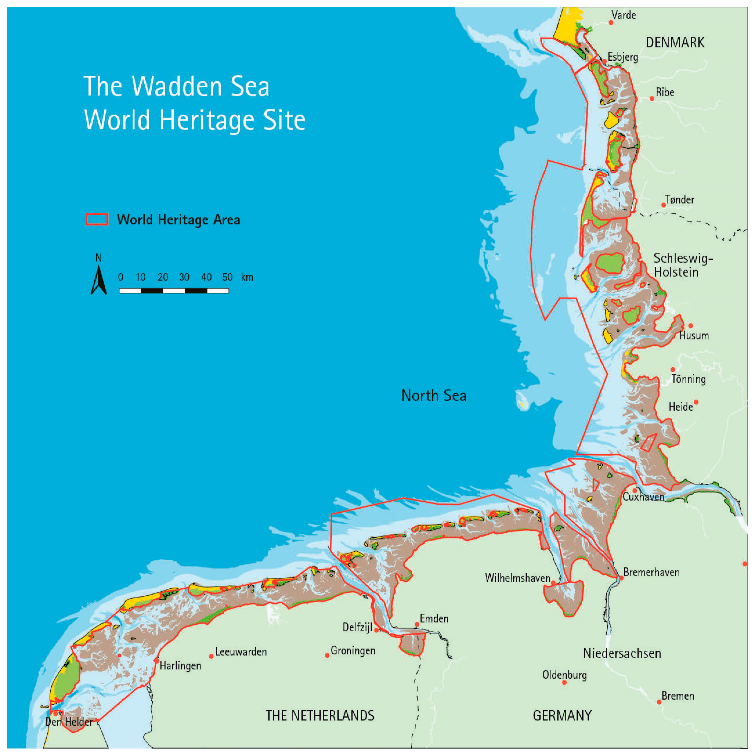
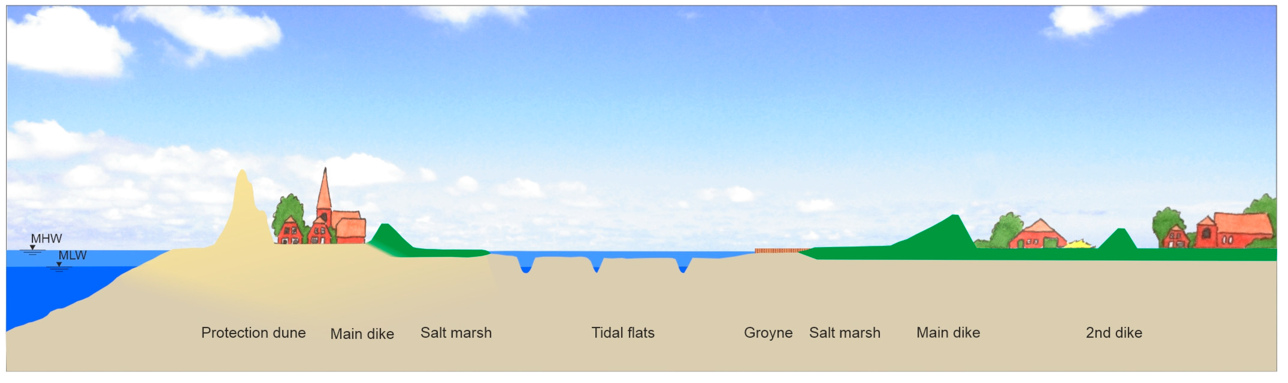
3.1. The Wadden Sea Area

The Wadden Sea is situated in the southeastern part of the North Sea, along the coast of the Netherlands, Germany, and Denmark. It covers an area of over 22,000 km2, making it the largest contiguous area of its kind. It has been designated as a UNESCO World Heritage Site [1,2,3].
The tidal range in the Wadden Sea varies considerably, reaching 1.4 m close to Den Helder and approximately 3 m in Cuxhaven [38,39,40]. This characterises the Wadden Sea as mesotidal [41]. The intensity of the sea water appearance results in a zonation of areas permanently covered by water (sublittoral), temporarily flooded (eulittoral) or without inundation (supralittoral) [42,43]. This is also reflected in the distribution of the typical Wadden Sea habitat types, namely salt marshes and mudflats [4]. The flat landscape of the salt marsh is structured by channels and creeks [44]. The mainland coast of the Wadden Sea is defined as a muddy coast, a ‘sedimentary-morphodynamic type’ consisting of predominantly fine sediment silt and clay [45]. The seaward-lying barrier islands provide protection from swell and enable the fine sediment imported through the North Sea and rivers, such as the Ems [39], to deposit in the intertidal zone [44,46,47]. In accordance with the gradient of energy, a grain size distribution from coarser to finer is observed as one proceeds landwards [48,49].
The Wadden Sea is of great importance for biodiversity, which is underlined by its status as a national park. This status provides a high level of protection [50]. Many species are highly adapted to the extreme conditions and depend on the preservation of these habitats. In addition to migratory resting and breeding birds, the Wadden Sea serves as a habitat for numerous small arthropod species, mainly insects and spiders, as well as vascular plant species [46,51]. Many people also live and work along the coast of the Wadden Sea [36]. In Lower Saxony and Schleswig-Holstein, the coastal region represents an important economic area [12,20]. The provision of an effective CFERM, as outlined in Figure 2, is a prerequisite for life in this coastal area [36]. Approximately 1.1 million inhabitants along the coast of Lower Saxony [14] and 330,000 inhabitants along the coast of Schleswig-Holstein [12] live in flood-prone areas.

3.2. Salt Marshes

Salt marshes emerge around the world along muddy coasts in temperate zones [52]. In tropical and subtropical zones, mangroves take the place of salt marshes in the wetlands [53,54]. In Europe, the Wadden Sea represents one of the main distribution areas of salt marshes [17,55]. The majority of the salt marshes developed with the support of technical measures [9]. Approximately 50% of the 40,000 ha of salt marshes are classified as foreland salt marshes [17].
The formation of salt marshes occurs in a low-energy environment allowing fine particles to be deposited, when there is sufficient sediment supply [39,54,56]. The material is transported in the water column by tides, which provide fine sediment. In storms, suspended grained sediment is deposited at the salt marshes [57,58,59]. Oost et al. [39] provide an overview of different sites along the Wadden Sea, demonstrating that the grain size distribution of salt marshes varies between sand and clay, with silt being the most prevalent material. Erchinger et al. [31] report that in the Buscherheller, located Northwest of Emden, clayey soil with a silt content of around 30 to 55% is present in the upper layer. In Schleswig-Holstein, Lenz et al. [58] conducted a study on an exposed and a back-barrier salt marsh. Both exhibited a predominantly silt and clay sedimentary composition, interspersed with thin layers of sand. In the exposed salt marsh, the grain size in the topmost layer was found to prevail generally <25 or <50 μm. In the sheltered site, the grain size in the uppermost 22 cm varied predominantly between 16 and 33 μm.
The plant species that inhabit the salt marshes are halophytes, adapted to the extreme conditions of regular flooding and high salinity levels. As elevation increases, the influence of seawater diminishes, resulting in the emergence of less adapted species [5,46,60,61]. As one progresses landward from the mudflat, the following vegetation zones are determined by the frequency of flooding: pioneer zone, lower salt marsh, and upper salt marsh [4]. Figure 3 illustrates the sequence of salt marsh plant communities in accordance with the frequency of flooding. It should be noted that the values represented by Erchinger [4] may slightly differ from those presented by other authors. The pioneer zone begins at a depth of 40 to 50 cm below mean high water (MHW) and is characterised by a frequency of daily inundation. This zone is indicated by the presence of the annual salt-tolerant therophyte Salicornia sp. representing the plant community Salicornietum [5,51,62]. In this zonation, Spartina anglica, a hybrid of the native species S. maritima and the introduced S. alterniflora, represents the more recently established plant community of Spartinetum anglicae. The species was introduced around 1930 in the Wadden Sea as a marsh builder and has partially replaced Salicornia sp. as a pioneer species [62,63,64].
The lower salt marsh appears around the MHW with an inundation frequency of 400 and 150 to 100 times per year [4,46,51]. The characteristic plant species is Puccinellia maritima, while in ungrazed areas, plant communities of Halimione portulacoides or Aster tripolium are observed [62]. The higher salt marsh is situated between 35 cm to 120 cm above MHW, with an inundation frequency between 200 to 100 and 50 to 20 times per year [4,51]. The plant communities of Armerion maritimae with Festuca rubra ssp. litoralis and Juncetum gerardii are dominant [62]. Salt marsh development is constrained by the landward area, which is not affected by sea water (epilitoral), and the seaward area, which is permanently submerged (sublitoral) (Figure 3).

3.3. Biogeomorphological Processes

The development of salt marshes is determined by the interaction between morphology and vegetation [65]. Processes influenced by this are sedimentation, erosion and the ability to attenuate waves and currents [66,67,68]. This results in the formation of distinctive landscape structures, including drainage structures [69,70].

3.3.1. Sedimentation Processes

Sedimentation is the process of deposition of sediment particles from initial suspension in water or air. On salt marshes, suspended sediments transported by seawater can settle when the flow velocity is reduced, for example by soil roughness or the presence of vegetation [71,72]. The process of sedimentation is influenced by the available amount of sediment [39], vegetation [71,73,74,75], and local morphology, including distance to sediment sources and elevation [48,75,76].
The quantity of sediment transported onto the salt marsh determines the capacity for elevation growth [77,78]. In the Wadden Sea, Heinrich [79] measured a depth-averaged suspended sediment concentration of 0.004 g/L in summer up to 0.019 g/L in winter in the Wadden Sea of Schleswig-Holstein. Furthermore, Oost et al. [39] report a significantly higher concentration of more than 0.1 g/L in the Weser and Elbe estuaries due to high turbidity. For the Wadden Sea, site-specific averages of suspended sediment concentrations near or on salt marshes are determined for Wadden Sea sites: near Delfzijl, 0.09 g/L [80]; Dollard Bay, 0.2 g/L [81], and the groyne fields of Cappeler Tief, 0.24 to 0.37 g/L [82].
The highest sedimentation rates are reported along salt marsh edges and channels due to the proximity of sediment sources and a positive feedback mechanism with vegetation [68,71]. Studies have demonstrated that sedimentation rates decline with increasing distance from the marsh edge [48,71,75,83,84]. For the mainland coast of Schleswig-Holstein, Bass et al. [71] observed an almost linear correlation. Furthermore, a decrease in sedimentation with increasing elevation is observed [75,85,86]. Areas below the mean high tide generally show a greater change in elevation, as noted by Suchrow et al. [75].
The presence of vegetation generally results in a lower flow velocity, which increases sedimentation rates [31,73]. A comparison of sedimentation rates in vegetated and unvegetated plots, measured with sediment traps, revealed that the average rate was 42% higher in vegetated than in unvegetated plots, after controlling for elevation and distance from sediment sources [73]. The effect of vegetation varies with the species present due to different plant characteristics such as height, shape, and density [48,71,75]. Taller and denser vegetation, such as Spartina sp., generally has a positive effect on elevation change [48,75]. Suchrow et al. [75] observed higher sedimentation rates of +14 mm/a in taller vegetation exceeding 30 cm in height compared to +4 mm/a in shorter vegetation measuring less than 15 cm. Based on their findings, Bass et al. [71] concluded that leaf characteristics are more relevant than stem characteristics. Additionally, several studies have focused on salt marsh plant communities. Koppenaal et al. [87] used sedimentation bars (SEB) to measure sedimentation rates in Noord-Friesland Buitendijks. The authors found a higher accretion rate in the low marsh, with +18.5 mm/a, in comparison to the high marsh, with +2.8 mm/a. In a salt marsh northeast of Harlingen in the Netherlands, Baptist et al. [88] observed higher accretion rates in the middle and high marsh than in the pioneer zone, as measured using SEB over a three-year period. However, these observations were based on a single event in winter. Baaij et al. [73] concluded that the presence of vegetation has the greatest effect on sedimentation in low-elevation areas such as the pioneer zone. However, as Wohlenberg [89] found for Salicornia herbacea (=europaea), this effect only occurs at a certain plant density. Furthermore, their function is influenced by seasonal changes in plant characteristics [85,90] or specific conditions of inundation depth or wind direction [91].

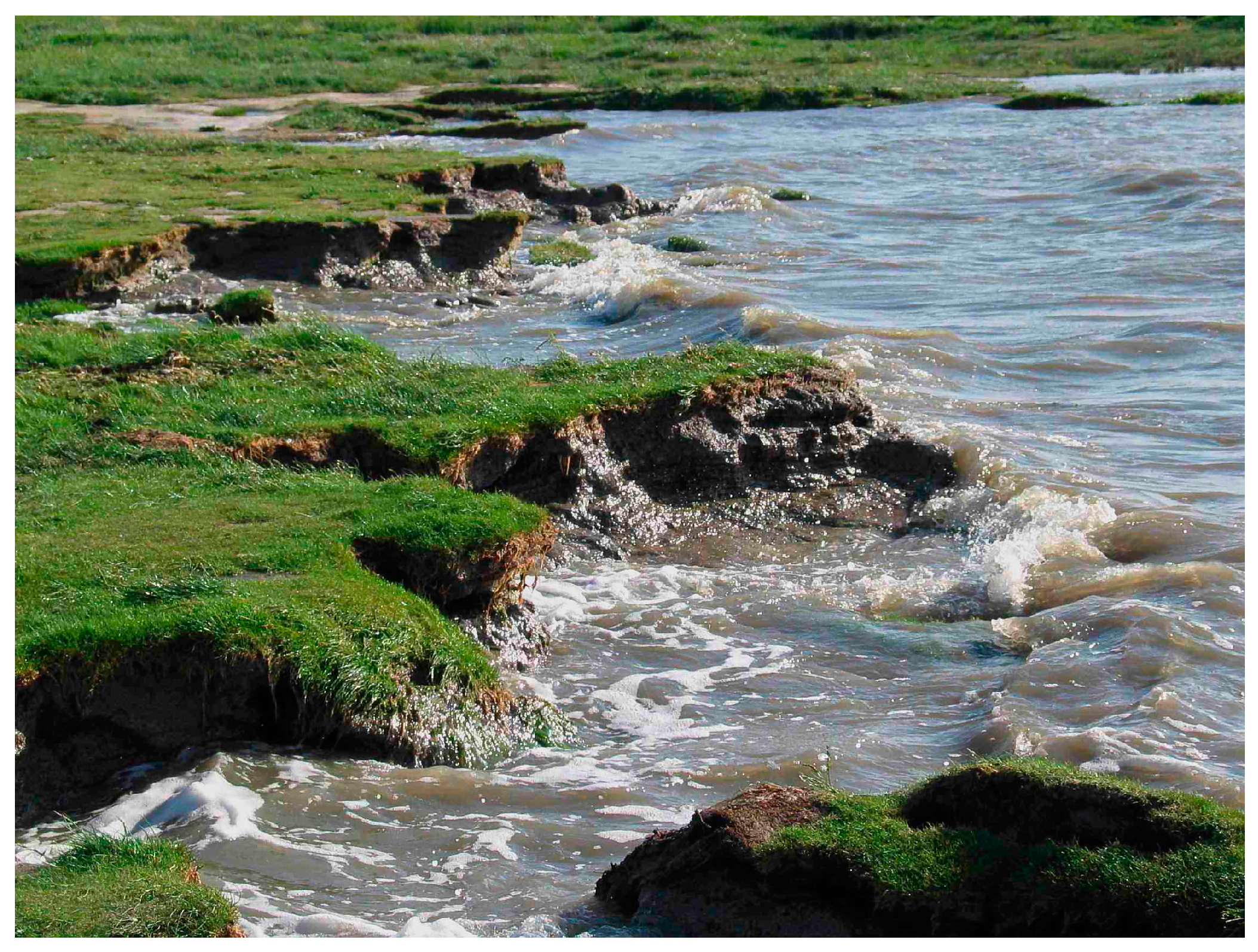
3.3.2. Erosion Processes

In salt marshes, erosion processes appear in the form of topsoil removal or lateral regression, which can result in reduced surface elevation or landward retreat, respectively [92,93]. Erosion is initiated when erosive forces, primarily caused by currents or wave action, exceed soil resistance [93]. In the literature, local morphology, such as elevation [31] and the presence of vegetation [10,94] are considered to have a critical influence on soil resistance.
Aggregate stability is a key indicator of soil resistance and is therefore an indicator of erosion susceptibility [31]. A positive correlation has been shown between erosion resistance with fine-grained soil, higher soil organic matter content, and the presence of vegetation [95,96,97]. In a flume, Marin-Diaz et al. [93] conducted an experiment to investigate the topsoil erosion resistance of salt marshes and tidal flats to a fast overflow of 2.3 m/s. With vegetation, a high resistance was measured regardless of the sediment composition. Without vegetation, silty sediments showed a higher resistance than sandy sediments. These results are consistent with the findings of Schoutens et al. [98] in a field study in the Elbe estuary and Bouma et al. [92], who investigated lateral erosion in the Western Scheldt estuary. Underlining the positive feedback mechanism, Baptist et al. [80] note that a higher mud (silt and clay) content of 25% compared to 7 to 9% in the marsh bed was associated with a denser plant cover. The stabilising effect of the presence of vegetation can lead to an increasing difference in elevation between the salt marsh and the adjacent tidal flats [74]. Bouma et al. [92] found that this can initiate lateral erosion. Between 1985 and 1992, Coldewey and Erchinger [30] measured a lateral retreat of the salt marsh edge on the East Frisian coast.
On average, a low-lying tidal flat (MSL +0.5 m) results in a loss of about 3 m/a and a higher-lying tidal flat (MSL +0.9 m) results in a loss of approximately 5 m/a. In a study conducted in the Dutch Wadden Sea, Marin-Diaz et al. [29] found that salt marshes with adjacent tidal flats higher than about MSL +0.5 m showed a higher stability.
Vegetation improves soil stability through above- and below-ground biomass, which is associated with a reduction in erosion [10,97]. Soil resistance is derived from the underground root mass and its vertical distribution [71,96]. According to Marin-Diaz et al. [93] this is best indicated by a fine root density of <0.5 mm diameter. Erchinger et al. [31] were also able to determine the correlation between below-ground biomass and soil resistance for ungrazed areas. Due to the year-round vegetation with belowground biomass, erosion rates remain low even in winter [31,94,98]. Paul and Kerpen [99] conclude that this effect is species-independent when comparing Spartina anglica and Elymus athericus in a flume experiment. However, when Spencer et al. [94] performed a flume experiment, they found that soil vegetated with Puccinellia showed less erosion than the other species. The authors conclude that the location of the vegetation appeared to be crucial in initiating erosion processes. The edges of the salt marshes are subject to particularly high levels of hydrodynamic stress [31]. Results from Wang et al. [97] suggest that erosion is less pronounced on vegetated edges than on unvegetated ones.
Hofstede [100] identifies three stages of salt marsh stability: stable, unstable and erosive. A stable salt marsh is characterised by a wide pioneer zone that is able to withstand incoming waves and can have a positive vertical and lateral accretion rate. The positive feedback mechanism of soil stabilisation and vegetation growth can result in a seaward expansion, leading to the formation of a gently sloping transition zone [74]. It should be noted that elevation change is only partially indicative of lateral growth. As Silinski et al. [101] found, this effect can be overshadowed by wave action in exposed areas. Expansion continues until the erosive forces exceed the stabilising ones [25,60]. As the salt marsh begins to destabilise, a steeper slope occurs at the edge of the salt marsh [74]. This effect can be attributed to an increasing height difference between the salt marsh and the tidal flat [66,74,102,103] or an increase in hydrodynamic stress [104]. Once the transitional zone has almost disappeared and eroding edges have appeared (Figure 4), the salt marsh enters an erosion stage, as stated by Hofstede [100] in [54]. From this point on, a landward retreat is expected to appear [25,60]. Tánczos [105] and Koppel et al. [74] state that in naturally developing salt marshes, a cyclical process of erosion and sedimentation coexists spatially, which can lead to salt marsh renewal.

3.3.3. Drainage System Morphology

Naturally developing salt marshes are characterised by extensive, winding creeks, as shown in Figure 5 and Figure 6, that allow tidal access [17]. The formation and development processes of the drainage system are described by observational studies and numerical models [70,106,107,108]. It is noted that their formation can be initiated by erosion or deposition of sediment due to local flow acceleration or deceleration, depending on the morphology and vegetation [109]. A self-reinforcing process of decreasing resistance and increasing flow velocity in these areas facilitates the stabilisation of the drainage system [70,110].
In salt marshes, vegetation influences tidal creek formation significantly, as evidenced by the findings of Temmerman et al. [107] and Vijsel et al. [108], using a hydro-morphological and a biogeomorphological model. Their modelling demonstrated that the initiation of creek development can be caused by erosion occurring between two vegetation stands. This impedes the flow of water, which subsequently changes the velocities of the flow. In their study of the Western Scheldt estuary, Schwarz et al. [70] modelled the influence of pioneer species on the structure of drainage systems depending on the relationship between lateral expansion and seedling establishment. The authors conclude that new creeks are more likely to form in areas with Spartina anglica, which is characterised by low establishment and high lateral expansion. In contrast, Salicornia europaea, with high establishment and low lateral expansion, tends to form a homogeneous, stable landscape. Bij de Vaate et al. [69] confirm these findings, indicating that the impact of Salicornia procumbens on creek development is negligible, whereas Spartina anglica and Puccinellia maritima have a significant influence. Additionally, Temmerman et al. [107] and Vijsel et al. [108] identify a positive correlation between denser vegetation and finer-scale branching. The authors state that this is explained by a higher concentration of flow between denser vegetation and vegetation that allows steeper banks due to higher erosion resistance. However, Temmerman et al. [68] observed that the sedimentation processes are influenced by the height of the water level above the vegetation.

3.4. Salt Marsh Management

Historically, salt marshes along the mainland coast of the Wadden Sea were mainly used for agricultural purposes [15]. In order to expand the agricultural area in addition to the naturally occurring salt marshes, extensive new salt marshes were developed using technical measures in the past [16,17,18]. Therefore, almost all salt marshes show effects of management [17]. Toward the end of the 20th century, the focus shifted as the importance of nature conservation increased [22,111]. However, the function of salt marshes in coastal and erosion risk management has been known for over a century and remains important today [9,11,13,21].

3.4.1. Influence of Management on Sedimentation Processes

The sedimentation process can be facilitated or, in areas with hydrodynamically unfavourable development conditions, made possible by management. In this context, engineering structures, such as groynes of various designs, are extensively used along the Wadden Sea coast in order to attenuate waves and currents [13,112,113]. According to Loon-Steensma et al. [114] processes like sedimentation and succession appear to be similar to those in natural salt marshes. Bakker et al. [115] found succession results in the same climax plant communities in naturally and anthropogenically created salt marshes. Arens and Götting [116] state that groyne fields without an artificial drainage system are evaluated as natural.
However, grazing has been shown to influence sedimentation and surface elevation [117,118,119]. Lower rates of accretion or elevation change are associated with higher stocking densities [117,118,120]. In the Leybucht, Erchinger et al. [31] investigated different stocking densities of cattle on salt marshes. The results showed sedimentation rates of 19.6 mm/a at 0.5 livestock units per hectare (LU/ha), 15.6 mm/a at 1.0 LU/ha, and 21.4 mm/a in ungrazed areas. Nolte et al. [91] attributed the direct effect of grazing by horses and cattle on soil compaction to trampling, while the indirect effect was attributed to the influence on vegetation structure. Trampling was cited by Elschot et al. [120] as the main reason for the lower elevation change of 3.6 mm/a in grazed compared to 11.9 mm/a in ungrazed areas in study sites along the Dutch coast. The influence of grazing on vegetation structure has been shown, for example, by decreasing plant height with increasing stocking density [48,117]. Neuhaus et al. [118] reported higher sedimentation rates in ungrazed or moderately grazed areas with higher vegetation than in intensively grazed areas with lower vegetation. Artificial furrows and ditches are implemented to improve surface elevation. However, no evidence of increased sedimentation rates was found [82,121]. Only ditch excavation spread across the beds leads to a higher surface elevation as described by Erchinger et al. [31].

3.4.2. Influence of Management on Erosion Processes

Measures such as brushwood groynes or artificial drainage systems are used to stabilise the foreland and prevent erosion [13,30,31]. Erchinger et al. [31] report that low-elevated salt marshes without furrows and ditches had lower resistance to erosion at flow velocities of 3 m/s than similar ones with these structures. Furthermore, salt marsh succession leads to a dominance of Elymus athericus in the long run, as found by Nolte et al. [122] for the West Coast of Schleswig-Holstein. This is associated with a decline in salt marsh biodiversity [122]. Klink et al. [123] and Bakker [124] indicate that the process can generally be slowed down or counteracted by grazing. In the absence of grazing or mowing, Chen et al. [125] observed a decline in plant diversity in a salt marsh, depending on the scale, with an average of 4 (local) to 11 (large) plant species over 48 years.

3.4.3. Influence of Management on Drainage System

Drainage systems are used for a multitude of purposes: in groyne fields, drainage furrows and ditches are used to promote the development of pioneer vegetation [31,36]. Nowadays, drainage systems in the salt marshes near the dike serve to ensure adequate drainage of the dike foot [22,23,31,36] and to allow grazing for management [126] and also for nature conservation purposes [22]. Artificial drainage systems differ from naturally developed drainage systems as they are designed in a linear and evenly distributed structure, as seen in Figure 6 [64,127]. Artificial ditches are wider and shallower and the drainage system is much longer and less branched compared to naturally developed ones [121,128]. A study by Reents et al. [129] examined the characteristics of drainage systems in salt marshes in the Netherlands, the United Kingdom and Germany. The artificial flow paths were found to be up to 900 m/ha long and in naturally developed salt marshes around 750 m/ha. In addition, the width variance was less pronounced. About 80% of the drainage systems of the artificial salt marshes were categorised as small, but only 55% to 60% of the natural salt marshes. The authors also found no salt pans associated with artificial systems, whereas salt pans constituted approximately 6% of the area of naturally developed salt marshes. The influence of drainage furrows on wave heights is investigated by Lieberman et al. [130] using a numerical model. The results demonstrate a wider range of wave heights in an area with furrows (3 to 8 cm) than in an area without (5 cm) furrows, and higher waves in areas with furrows in groyne fields. As observed by Duin et al. [131], the presence of furrows leads to a greater differentiation of the elevation range in sedimentation processes. This accelerates the succession and increases the number of species present in the higher salt marsh. The construction of artificial drainage structures has been observed to result in a lowering of the vegetation boundary of the pioneer and lower salt marsh zones by 0.2 m [11,121,132,133].

3.5. Impact of Climate Change

The impact of climate change on salt marshes has been investigated in several modelling studies [32,78,134,135,136]. Dobben et al. [137] studied salt marshes on Ameland, which were subject to subsidence of up to 0.7 cm/a and gradually increasing flooding due to gas extraction. This is considered comparable to the effects of SLR. The study’s findings indicate that areas with sufficient sediment supply can cope with an SLR of 0.8 cm/a, whereas areas without sufficient supply, such as the inner marsh, are unable to do so. A study by Timmerman et al. [32] predicts a reduction or even disappearance of the salt marsh in the Dutch Wadden Sea by 2100, with a SLR in the range of 0.8 m to 1.8 m based on the IPCC 2019 SLR projections. For the Schleswig-Holstein Wadden Sea, Hofstede et al. [33] expect a minor loss of salt marsh area with a SLR of 0.3 m by 2050, which would result in a significant loss of salt marsh area with a SLR of 0.8 m by 2100 based on IPCC 2013 SLR projections. For the Wadden Sea, Nevermann et al. [134] predict a loss of wetland area of at least 2.6% with a SLR of 1 m. Erosion processes are mostly concentrated at the seaward edge of the salt marshes, which is predicted to shift more and more landwards [33,136]. The pioneer zone is particularly affected as it is located seaward, and thus a significant decline is expected [33,43,138]. Furthermore, increased inundation is also projected to affect salt marsh plant communities. As a consequence of the projected increase in SLR, it is anticipated that there will be a landward retreat of vegetation zones [139,140]. According to Brouns [60], plant communities are sensitive to rapid SLR. The authors state that the pioneer zones (Spartinion) can withstand a maximum sustainable rise of 30 to 40 cm, the lower salt marsh (Puccinellion maritimae) of 10 to 15 cm and the upper salt marsh (Armerion maritimae) of 3 cm. However, landward retreat is only possible as long as there are no obstacles preventing relocation [54]. As observed by Nevermann et al. [134], infrastructure in coastal areas is likely to act as a barrier to natural landward migration at the North Sea, leading to coastal squeezing.
Climate change may also lead to changes in vegetation growth or species composition [141]. Koop-Jakobsen and Dolch [142] measured that an increase in temperatures of +3 °C above the present temperature and a CO2 concentration of 800 ppm resulted in higher biomass production for Spartina anglica and Elymus athericus. The authors conclude that climate change may increase the biomass of pioneer species, thereby increasing the resistance of the transition zone. This may affect the structure of drainage systems or the capacity of wave attenuation due to changes in species composition [61,69,136,143].
It is anticipated that salt marshes will be able to mitigate the effects of SLR to some extent, as evidenced by studies (e.g., [36,78,144]). However, there is considerable debate in the literature regarding the limits of salt marshes’ ability to adapt to SLR. According to CPSL [36] salt marshes are expected to be submerged at 8.5 mm/a SLR, with the pioneer zone being more vulnerable at 3 to 6 mm/a SLR. Dijkema [43] concludes that salt marshes in the Netherlands can cope with a SLR of 10 mm/a on the mainland coast and 5 mm/a on the islands. For the coast of Schleswig-Holstein, Hofstede et al. [33] predict that the majority of salt marshes will remain intact at a SLR of 4 to 10 mm/a. Suchrow et al. [75] conducted a study along the Schleswig-Holstein coast and found that a SLR of 6 mm/a is expected to threaten half of the sites studied, while most salt marshes can cope with a SLR of 1 to 2 mm/a.
The growth rates of these marshes are strongly dependent on the availability of fine sediment. In the absence of an adequate supply of sediment, salt marshes are projected to become submerged over time [77,78,144]. In the case of Dollard Bay, Kok et al. [81] conclude that if the average suspended sediment supply of 2 g/L was halved, salt marshes would no longer be able to fully fulfil their function in CFERM. For the Hallig Langeness, 0.15 g/L of suspended sediment was predicted to be sufficient to cope with a SLR of 5 mm/a [145]. For the Western Scheldt, Hu et al. [144] mechanistically modelled the effects of 20 mm/a relative SLR on seedling establishment in salt marshes. Their findings indicate that with a sediment supply of 0.12 g/L, the pioneer marsh is capable of maintaining equilibrium with SLR.
Best et al. [78] numerically modelled that salt marshes in the Western Scheldt would be affected by at least partial inundation with an accretion rate of 1 to 3 mm/a, regardless of the applied SLR projections of 0.6 to 1.137 m MSL in 100 years. However, if an accretion rate of 5 to 9 mm/a is applied, the results show a stable or even expanding salt marsh. The prediction of sediment transport and availability is difficult due to a variety of influencing factors and processes [39,60]. A first attempt to analyse the mud balance for the Wadden Sea was made by Oost et al. [39]. The results indicate that sedimentation rates are currently keeping pace with SLR, but that a shortfall of around 4 to 6 mm/a SLR is predicted. Andersen et al. [77] indicate that there is currently a decrease in sediment availability for the salt marsh in Skallingen, Denmark. However, the future development of sediment sources and hydrological forces is subject to high uncertainty. Schuerch et al. [135] state that an increase in storm frequency may be associated with an increase in sedimentation of up to +3 mm/y by 2100. Other studies have indicated that areas with high tidal ranges have a greater potential to be supplied with higher amounts of sediment [146,147,148]. In addition to these aspects, grazing management plays an important role as it can hinder or promote sedimentation [120].

4. Hydrodynamic Processes

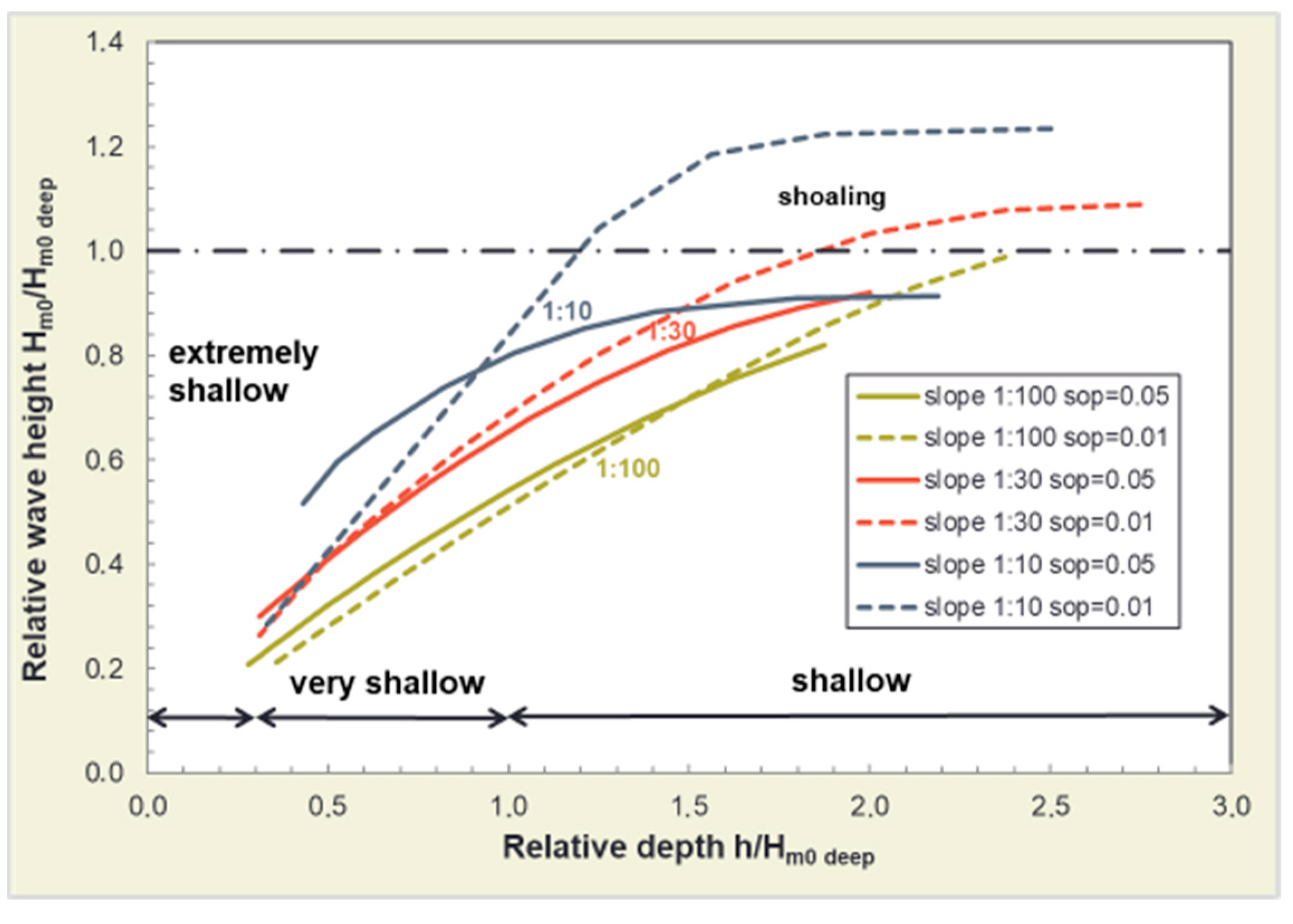
4.1. Effects on Wave Climate

Along the mainland coast, salt marshes are situated on the seaward side of dikes [44,46]. They are exposed to swell, although to a reduced extent, as they are protected by higher tidal flats and islands, which provide less water depth and reduced wave heights [47]. It has been observed that waves lose energy when they reach a salt marsh [7]. This is explained by the difference in height between tidal flats and the salt marsh, which leads to wave breaking due to the reduction in water depth [8]. As water depth determines wave height under shallow water conditions a depth-induced wave height reduction can occur [149]. Figure 7 illustrates the reduction of wave height (Hm0) depending on the relative water depth (h/Hm0 deep), the foreshore slope and the wave steepness [8]. Wave breaking does not occur in deep water depth (h/Hm0 deep > 4), only under shallow (4 > h/Hm0 deep > 1) to very shallow (1 > h/Hm0 deep > 0.3) conditions. Further, the relation of different relative water depths to the wave spectra/period is shown in Figure 8. Waves reaching the coast in deep or shallow water depth almost show no change in wave period. However, under very shallow conditions, Tm-1,0 may increase [8]. Further, bottom friction, due to uneven soil or vegetation, causes wave height reduction [150,151,152]. It has been stated that this effect also occurs in deep water conditions, where wave breaking is less significant [8].
It has been established that CFERM benefits from the contribution of salt marshes to flood risk reduction [11,14]. Various studies have demonstrated that salt marshes have the capacity to attenuate waves [29,143,149,153]. In front of a dike, they can reduce the impact of waves on the protection system [11,31], acting primarily in the processes of wave breaking and wave run-up [154].
Figure 9 shows that energy dissipation is distributed more evenly with a foreland compared to without. Furthermore, the presence of a foreland is shown to reduce the negative effects of a dike breach [155]. In their respective works, Erchinger [9], Erchinger and Thorenz [126], and Thorenz and Carstens [22] state that with the presence of a sufficiently elevated and extensive salt marsh, a massive dike foot can be dispensed as protection against hydrodynamic effects. This effectively enables a more seamless transition from the dike to the salt marsh.

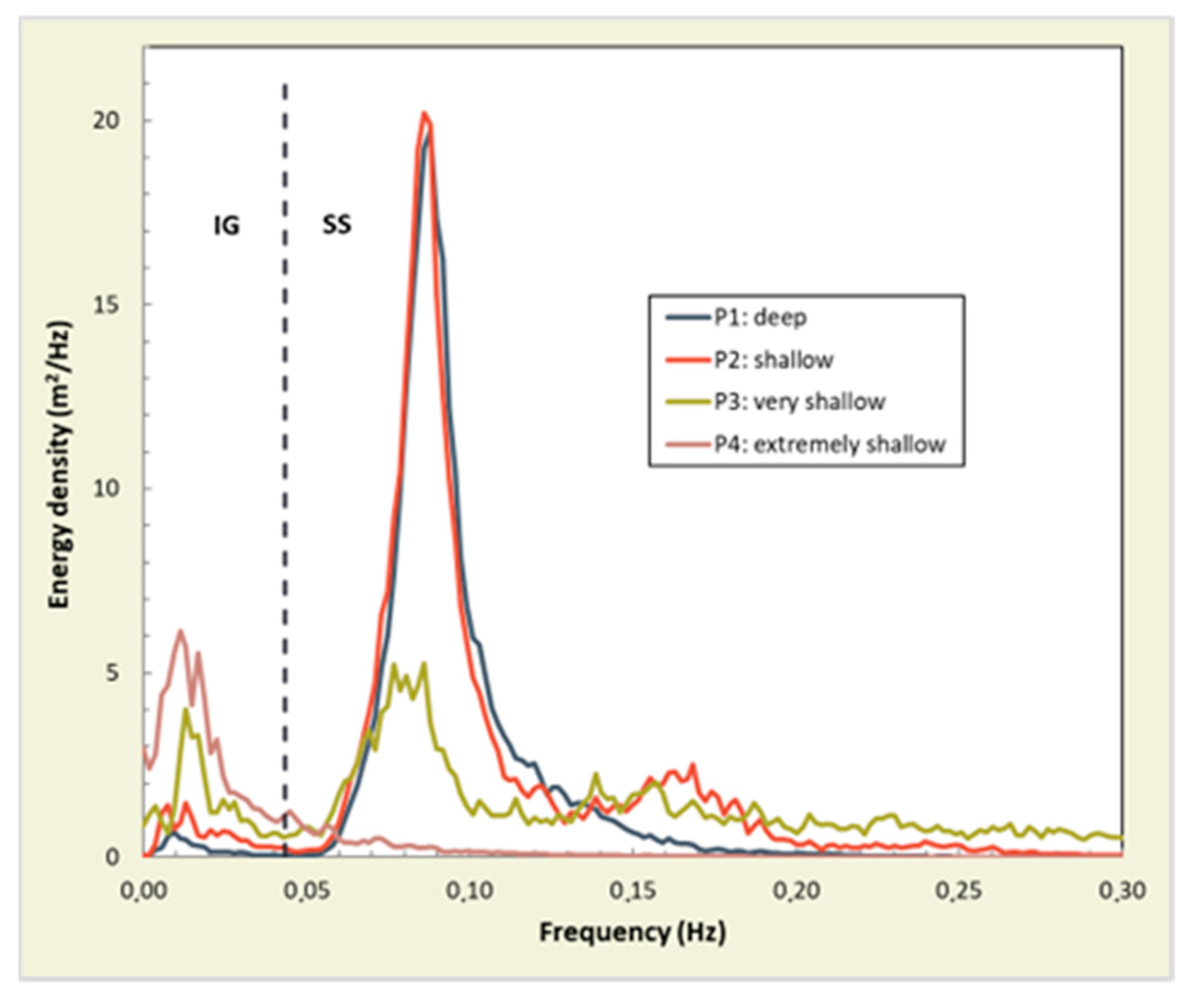
4.1.1. Wave Attenuation by Salt Marshes

The attenuation of waves by forelands has been described in several publications in the field of literature. In a flume study conducted by Möller et al. [157], a reduction in wave height of up to 19.5% was observed over 40 m length (0.5%/m; T: 3.6 s, H: 0.3 m, h: 3.5 m on tidal flat). Marin-Diaz et al. [29] identify a significant reduction of wave height of over 80% over a distance of 300 to 400 m on three different sites in the Netherlands (0.28 to 0.32%/m; Hs: 0.5 m, h: 1.8 m on tidal flat). Modelling with SWAN, Loon-Steensma [158] reports wave attenuation of up to 0.22%/m for waves heights of 0.5 and 0.15 m, a wave period of 2.5 s period and a water depth of MSL +0.95 m across a 350 m transect of densely vegetated salt marsh.
Vuik et al. [149] note that the majority of previous research has focused on low wave heights of 0.1 to 0.3 m or water depths below 1 m. As part of this study, additional publications were identified that provide supplementary data to the existing body of knowledge. In flume studies, values up to 1 m wave height with a 5.4 s wave period and 4.5 m water depth on a tidal flat were found in Mai and Lieberman [159], while in Niemeyer and Kaiser [160] a 0.93 m wave height and 4.9 m water depth on the tidal flat was observed. In situ, Vuik et al. [149] observed water depths of 2.5 m and wave heights of 0.7 m with wave periods of 2.5 to 3.5/4.0 s on salt marshes in the Westerschelde. The authors state that the ratio of wave height to water depth at the marsh edge influences the reduction of wave height by the foreshore. It is concluded that wave energy reduction occurs at high ratios of >0.30, predominantly due to depth-induced wave breaking, and at lower ratios of 0.15 to 0.30, where vegetation-induced friction can be substantial. At low ratios of <0.15, the influence of the foreland and vegetation is stated to be minimal [149]. Willemsen [161] observed that a slightly larger ratio of 0.4 (Hm0,design: 2.4 m; hnorm: 6.0 m; Tm-1,0,design: 4.7 s) appears at sheltered locations compared to a ratio of 0.3 (Hm0,design: 1.7 m; hnorm: 6.3 m; Tm-1,0,design: 4.4 s) at exposed ones. It can be reasonably assumed that this will have an effect on wave attenuation, given that a higher reduction per metre occurred on the sheltered sites.
In stormy conditions, Niemeyer and Kaiser [160] argue that forelands have a negligible influence. The authors propose that the critical wave-breaking value will not be reached due to the low ratio of wave height to water depth during storm surges. Nevertheless, more recent flume [157], model [149,161], and field [29] studies have observed wave attenuation under extreme conditions. However, a reduced impact is expected with higher water depths [153]. A number of studies have concluded that the reduced effect should still be considered [157,158,162]. Vuik et al. [149] report that salt marshes can have a significant impact on wave run-up at dikes during storm surges. When modelling 3 m water depths on a salt marsh of 400 m with a significant offshore wave height of 1.5 m and a period of 5.0 s, the results indicate a reduction in wave run-up of up to 55%. These findings are supported by those of Erchinger [4]. The author observed wave run-up of 1 m and 3 m on dikes with and without forelands, respectively, after the severe storm surge event of January 1976 along the East Frisian Coast.

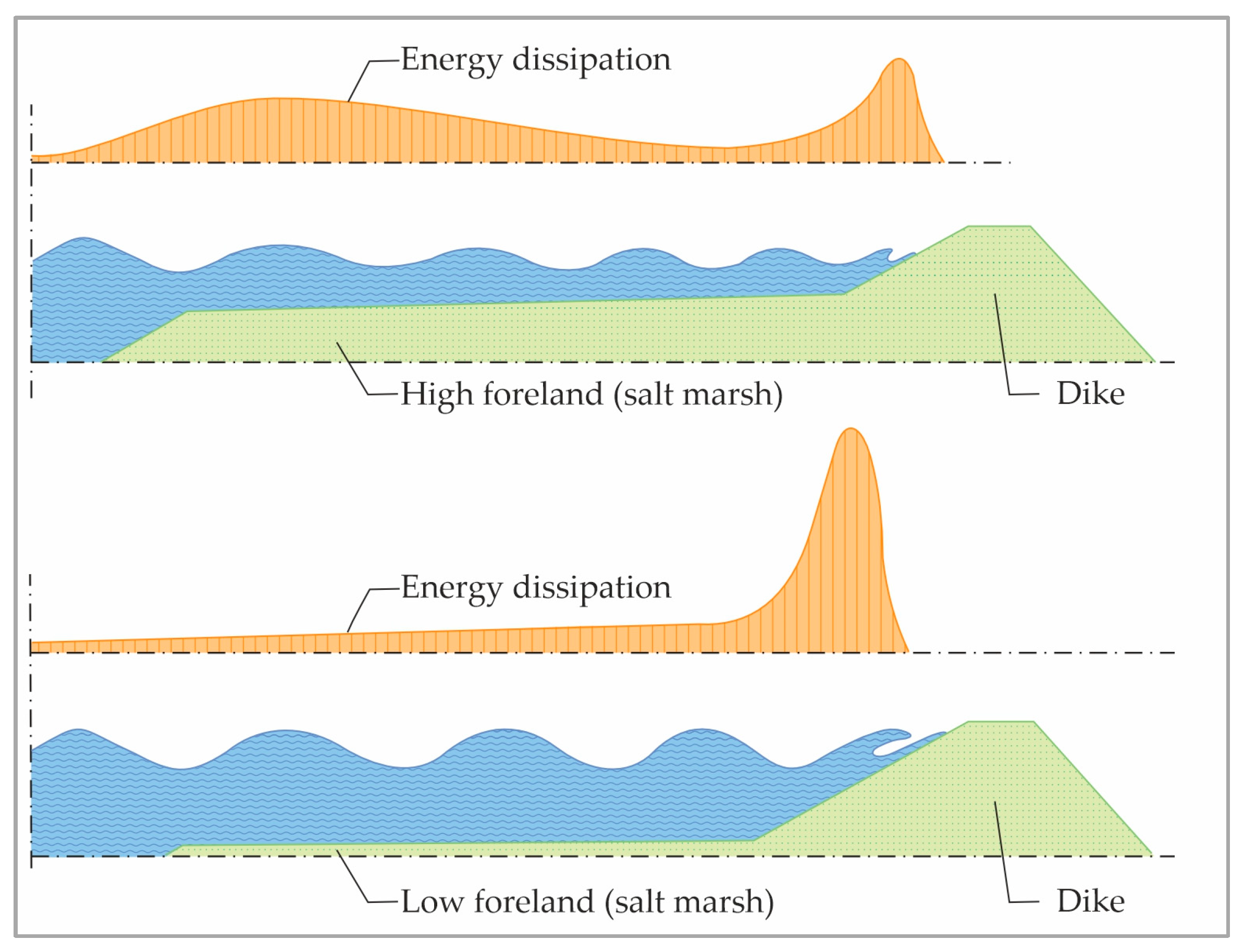
4.1.2. Influence of Salt Marsh Geometry on Wave Attenuation

The geometry of the foreland, including width, height, and slope [29,159] exerts a significant influence on the wave climate. An increase in the height and width of salt marshes is associated with a reduction in wave height/energy [10,143,149,161,163].
The greatest depth-induced wave reduction was observed to occur over the first metres [164]. Möller and Spencer [7] observed a wave attenuation of >40% over the initial 10 m from the edge of the salt marsh. The significant mean wave height was 0.26 m, the wave period 3 s and the mean water depth 1.41 m on the tidal flat. Lüders and Leis [165] state 200 m as a ‘sufficient width’ (Lower Saxony Dyke Act) of the foreland for CFERM. Mai and Lieberman [159] numerically modelled an optimal width of 325 m using results from a flume experiment. A salt marsh width of 300 m with a height of MSL +1.5 m was found optimal by Marin-Diaz et al. [29] in a numerical modelling study using field measurements. The authors conclude that if the foreshore is higher or is exposed to lower wave loads, a width of even 100 m can still be sufficient. Consequently, a higher but narrower salt marsh is expected to be more effective than a lower and wider one [29,161].
Steeper slopes show a higher wave attenuation capacity than shallower ones [149,161]. Mai and Lieberman [159] examined different bed slope angles and concluded that significant wave height reduction is higher at a steeper (1:400) than at a shallower (1:1200) or horizontal foreland. Möller and Spencer [7] observed different wave attenuation processes at a ramped and steep transition from tidal flat into the salt marsh in the UK. They noted that directly in front of a steep edge, the wave attenuation decreased on the tidal flat by 0.54%/m and then increased considerably on the salt marsh by 7.91%/m. On the tidal flat, significant wave heights averaged 0.29 m, with a wave period of 3 s and an average water depth of 1.84 m. A more gradual wave attenuation was observed in the flat transition of 0.24%/m on the tidal flat and 0.61%/m on the salt marsh. On the tidal flat, significant wave heights averaged 0.26 m, with a wave period of 3 s and an average water depth of 1.41 m.

4.1.3. Influence of Vegetation on Salt Marshes on Wave Attenuation

In terms of wave attenuation, vegetation is attributed to 9% [153], ca. 40% [98] or up to 60% [149,157]. In their study, Vuik et al. [149] found that vegetated salt marshes can act in lower wave height-to-water depth ratios, thereby expanding the range of affected waves. Additionally, the authors concluded that, in the presence of vegetation, wave breaking occurs in a more gradual manner. In cases where vegetation is located directly at the salt marsh edge, it is less significant than depth-induced wave breaking [7].
In general, a higher wave attenuation is observed in the presence of denser and higher vegetation [166,167,168]. Loon-Steensma [158] applied numerical modelling to analyse waves of varying heights (0.5 to 0.15 m), periods (2.5 s), and depths (MSL +0.95 m at a distance of 2000 m from the shoreline). The highest wave attenuation of 0.22%/m was measured on densely vegetated forelands with 21,800 stems/m2. The lowest impact of 0.13%/m to 0.14%/m was seen by unvegetated and sparsely vegetated areas with 1000 stems/m2. In a flume test, Maza et al. [169] investigated the attenuation of wave energy by standing biomass of different species. Regular and random waves with heights of 0.05 to 0.15 m, over periods of 1.5 to 4.8 s, and with water depths of 0.20, 0.30 and 0.40 m were tested. A comparison of the attenuation values for 50% and 100% standing biomass density revealed that irrespective of the species, the attenuation was greater in the 100% density scenario. In a flume test with surrogate vegetation stands, Keimer et al. [153] observed a greater mean reduction in wave run-up of 12.1% when vegetation was 0.25 m high, in comparison to a reduction of 7.4% when vegetation was 0.1 m high. A density of 400 per m2 resulted in a 15.7% reduction, in comparison to a 10.4% reduction with a density of 200 per m2. The test parameters were found to range from Hm0,1: 0.08 to 0.20 m and Tp,1: 1.0 to 5.0 s. A study [170] used numerical model calculations with SWAN to demonstrate that if the first 100 m are vegetated with a density of 50% (250 units/m2), then up to 95% of wave energy can be reduced in a low (H = 1 m, T = 6 s) to high (H = 5 m, T = 12 s) wave scenario.
Furthermore, species show variation in their biomechanical properties [67]. Peralta et al. [67] indicate that stiff plants have a higher capacity for water energy reduction than flexible ones. Spartina anglica is to be three times more effective than Zostera noltii [167] and twice as effective as Elymus athericus [171]. These characteristics are not only variable between species but also within a single season. Spartina anglica shows 5.0 times higher values in summer than in spring, as found by Schulze et al. [90]. Further, Keimer et al. [172] provide an extensive overview of the existing literature on the biomechanical properties of Spartina sp.
The findings of previous studies indicate that wave attenuation by vegetation is most significant when the water depth is equal to or below the height of vegetation. Additionally, the evidence suggests that as the water depth increases, the attenuation of waves tends to diminish [153,167,169,173,174,175]. Bouma et al. [167] observed no wave attenuation with 100 mm high vegetation and 240 mm of inundation. However, wave attenuation was measured with 240 mm high Spartina anglica vegetation under both 240 mm and 120 mm of inundation. From a certain water depth of above 1.5 m, as measured in the field by Schoutens et al. [98], or above 2.5 m, as modelled by Möller et al. [175], no differences could be discerned between vegetated and unvegetated situations.
In the context of high-stress wave environments, vegetation may flatten or even break, as shown by Vuik et al. [176]. In their study, the authors investigated the behaviour of Spartina anglica under increased orbital velocities, showing that the plants remained stable at a mean critical velocity of 0.5 to 1.2 m/s; however, they eventually bent or broke. Research by Paul and Kerpen [99] indicates that Elymus athericus can withstand even less stress than Spartina anglica. While the loss of aboveground vegetation is associated with an increased vulnerability to soil erosion, studies by Leuven et al. [177] or Spencer et al. [94] suggest that roots and ground-covering biomass contribute to enhanced resistance.
Seasonal differences have been observed in wave attenuation, with lower rates in winter, for instance by Schoutens et al. [98] with 50% from May to August and 10% from December to March and Vuik and Jonkman [152] with 65% from July to September and 35% from January to March. The authors conclude that this is related to the vegetation growth cycle and the resulting seasonal differences in aboveground biomass. This is consistent with the findings of Möller and Spencer [7] and Silinski et al. [101]. Schoutens et al. [98] report that this is particularly true for the pioneer zone with annual plants, which perish in the autumn and grow new shoots in spring. The authors posit that a more uniform wave attenuation can be expected in the higher salt marsh due to lower biomass losses.

4.2. Limiting Impacts of Dike Breach

In the event of a dike breach, the presence of a stable salt marsh can reduce the dimensions of a dike breach and the flooding impact on the hinterland [9,143,178,179,180]. This is supported by a hydro-numerical model study conducted by Thorenz et al. [155]. The authors calculated the impacts of varying foreland heights of MSL +1.75 m, 2.00 m, and 2.25 m, widths of 50 m, 100 m, and 200 m and hinterland levels on inflow volume and inundation depth. Simulations indicate a reduction of up to 60% or up to 32% of the initial inflow volume with a foreland of 50 m width and height of MSL +1.75 m or 200 m width and height of MSL +2.25 m, respectively. Moreover, the average inundation depth of 0.36 m without foreland is reduced to 0.27 m to 0.20 m with a 50 m width and MSL +1.75 m to 200 m width and MSL +2.25 m, respectively. In case studies, conducted along the East Frisian coast, the positive impact on inflow volume, as demonstrated by the numerical model, was confirmed [180]. Hoven et al. [178] measured a reduced breaching zone and inflow time. In the event of a dike breach, the impacts, such as casualties, physical damage to infrastructure and buildings and the loss of the environment, are likely to be reduced. For the city of Cuxhaven, Mai and Zimmermann [181] calculated that the damage to land uses in the event of a failure would be reduced by 36.2 to 35.2% with foreland.

5. Management of Salt Marshes in the Wadden Sea

5.1. Salt Marsh Types and Development Goals

In order to take appropriate management steps, especially in the context of future SLR, it is essential to analyse both the initial and the target state of salt marshes [182]. In the Wadden Sea, salt marshes are distinguished according to their developmental mechanisms and structural characteristics. The Wadden Sea Plan [1] and the Wadden Sea Quality Status Report [17] differentiate between naturally developing and artificially created so-called ‘foreland salt marshes’ along the mainland coast. The Wadden Sea Plan [1] provides the following definitions:
“NATURALLY DEVELOPING SALT MARSHES have a drainage system of irregular, winding gullies, a zonation of subtypes reaching from a pioneer zone up to higher saltmarshes and in most cases transition to dunes, and—in the course of time—formations of salt marsh cliffs between older parts on the one side and pioneer zones on the bordering tidal flats on the other. Natural salt marshes can be found on the islands on the landside of dune areas and, in some places, along the mainland coast.”
“FORELAND SALT MARSHES are salt marshes which have developed or which development has accelerated through active human interference […]. They are mainly situated in places where natural developments would not have led to salt marsh formation.”
The development goals for salt marshes are contingent upon the requirements of nature conservation and CFERM. Regarding nature conservation, the natural processes serve as a model for the objectives also in the artificially created foreland salt marshes, as seen in Thorenz and Carstens [22] and Esselink et al. [17]. As described in Section 3.3.3, this includes the natural processes that form branched drainage systems and enable the development and maintenance of all succession stages. The Habitats Directive [183] lists the habitat types as saline pioneer stages with Salicornia sp. (1310) and Atlantic salt marshes (1330) in Appendix I. The Habitats Directive states that the goals for these habitat types are to preserve the distribution area, natural structures and functions as well as the characteristic species.
For CFERM, salt marshes provide a range of ecosystem services, primarily including wave attenuation, a naturally designed dike foot without the necessity for massive construction and the limitation of flooding in the event of dike breaches [9,11,14,143,179]. In the German federal states of Lower Saxony and Schleswig-Holstein, the Dike and Water Acts impose requirements for the maintenance and preservation of the salt marshes as a protection element for the primary sea dike ([19], § 21; [184], § 60). In order to fulfil these services, salt marshes require a certain width and height. However, the precise dimensions of these features are still under discussion, as stated by Marin-Diaz et al. [29]. The role of vegetation in CFERM is also a topic of interest. However, the extent to which this contributes to flood protection remains unclear [29,149]. In general, denser and higher vegetation is associated with a higher wave attenuation and a lower erosion risk [166,167,168]. Despite remaining uncertainty regarding the inclusion of salt marshes in CFERM [27,28,185], there is already substantial evidence to suggest their value, as Erchinger [4] and Zhu et al. [143] have observed.

5.2. Management Techniques

5.2.1. Sediment Nourishment

Sediment nourishment is the process of placing sediment onto or in close proximity to the site that is to be nourished [186,187]. This measure has already been widely used for the nourishment of sandy beaches and shores [11,188,189,190,191]. In the context of salt marshes, the placement of sediment, either directly or indirectly, is a suggested approach [186,192]. The direct application of sediment can be used to elevate the surface of an existing salt marsh or to create a new one [88,193]. In an existing salt marsh, the application of sediment is recommended to be in a thin layer of a few centimetres [192,194]. For the establishment of salt marsh vegetation on a tidal flat, it is recommended to construct a sediment base with a depth equal to the MHW, which enables pioneer plants to establish [195]. This approach has been implemented in the salt marsh pilot project Marconi near Delfzijl, where a sandy base and mud content in the first metre of the upper layer has been applied [195]. The seaward slope is suggested to have an inclination of 1% [196] and the salt marsh to have an angle of 3% to 5% [186]. To prevent soil compaction and facilitate the establishment of vegetation, the use of low-pressure equipment is recommended [186]. The application of sediment can be conducted indirectly in order to facilitate more widespread distribution [193]. Piercy et al. [192] propose the introduction of sediment into the estuarine environment or in close proximity to the coast or tidal flat, where it can then be transported by natural processes to the designated areas [197]. In the Mud Motor project, sediment was deposited in a tidal channel to nourish a salt marsh in the vicinity of Harlingen in the Netherlands [88]. It was modelled that the sediment is carried as suspended material onto the designated salt marsh. The accretion of 10 cm was observed to occur within a few days, with a greater quantity of material being deposited during periods of additional material addition. Nevertheless, it is assumed that local hydrodynamic forces hinder lateral salt marsh growth. The authors conclude that a more comprehensive understanding of the distribution mechanism and its efficiency is essential for successful implementation. Schulz et al. [187] found that wind can influence the transport of sediment. More than two-thirds of the material was not transported to the desired location when wind conditions were unfavourable and less than 10% when the conditions were favourable. With respect to the nourishment material, it is advisable to use sediment that is free from contamination and compatible with the sink habitat [193,196]. The material often originates from dredging activities in ports [186]. In the Mud Motor project material from the Harlingen Harbor was implemented for nourishing a nearby salt marsh [88]. The implementation period for the Mud Motor project was set between September and April in order to reduce the impact on the environment [88]. Groot et al. [198] state that nourishment is only useful if a deficit in sediment is identified. In such cases, the implementation has the potential to reduce erosion and secure salt marsh edges. Depending on the local circumstances, it is considered a more natural alternative to the application of groynes by Hofstede et al. [33].

5.2.2. Groynes

In the Wadden Sea, hydraulic engineering measures that are used in the context of salt marshes are predominantly groynes [13]. The most commonly used are brushwood groynes, comprising a double row of wooden poles filled with brushwood or in a high-energy environment rock groynes [113,199]. They are constructed in the tidal flats seaward of the coastal protection systems and form rectangular sedimentation fields, which are arranged in a net-like structure [16]. The dimensions of the fields vary regionally and have changed over time [43,199,200]. For a more comprehensive overview, see Reimers et al. [113]. The dimensions of sedimentation fields referenced in the literature range from 100 m × 100 m to 400 m × 400 m [16,43,112], with up to three fields present in a row perpendicular to the coastline [127]. The groyne height ranges from 0.3 m to 0.5 m above mean high tide [31,113,201], while the widths vary from 0.25 m up to 0.75 m [112].
Dijkema et al. [202] observed a sedimentation rate of 2.5 to 7.5 cm/a in a 400 m × 400 m groyne field in the first four years following implementation. In numerical tests, Lieberman et al. [130] determined that groynes are capable of reducing up to 55% of the wave energy, effectively performing to a water height of up to 60 cm above their crest. The effect is illustrated in Figure 10. The reduction in wave height observed by Erchinger et al. [31] was dependent on the groyne height. For a water depth of MHW to MHW +0.85 m and a crest height level at MHW, a reduction of 25% was measured, while for a crest height level of MHW +0.3 m, a reduction of 50% was observed. Lieberman et al. [112] found that a brushwood groyne of 25 cm width was less effective than a groyne of 50 or 75 cm width for wave height reduction, particularly when the water depth reached the top of the groyne. Furthermore, flow velocity in the sedimentation field was found to increase, when soil was attached to the sides at a height of 17 and 30 cm. According to Fiege and Hagmeier [199] sedimentation fields of 400 m in size are generally sufficient in the Wadden Sea. However, if the hydrodynamic forces are too large, smaller fields have been shown to enhance sedimentation [43]. To reduce the size of the sediment field, additional cross fences and, if necessary, main fences can be implemented [199]. Furthermore, Lieberman et al. [130] observed that sedimentation rates are dependent on the width of the seaward opening in the fields. A series of numerical tests with opening widths of 25 to 90 m indicated a reduction in the quantity of sediment deposited with an increase in the opening width.
Groynes may interfere with the natural dynamics of salt marshes and other valuable habitats, such as tidal flats, according to Jong et al. [203]. The natural dynamics of salt marshes include eroding processes [74,105]. The stabilisation effect of groynes results in the succession of vegetation, which negatively impacts biodiversity in the long run, as Nolte et al. [122] state. Foreland salt marshes would not exist in the absence of technical measures [36]. Furthermore, the anthropogenic-induced sediment process due to groynes is similar to the natural processes, as indicated by studies [114,115,116]. Esselink et al. [17] propose that an adaptive management approach should be considered for foreland salt marshes, allowing temporary erosion. In terms of CFERM, the objective is to preserve and, when necessary, develop the foreland salt marshes according to Hofstede et al. [204] and Thorenz [13,14]. Groynes prevent erosion and stabilise forelands [30]. They represent a significant element of the CFERM in Lower Saxony, especially in the context of eroding salt marshes, which are used as nature-based elements [14].

5.2.3. Drainage System Management

As priorities shifted from agricultural use towards integrated management, drainage measures also changed [17,22,23,36]. Historically, artificial drainage systems were implemented as a net-like structure of furrows and ditches in order to drain large areas [64,127]. The width of these furrows and ditches was typically between 0.4 m and 2.0 m wide, while their depth ranged from 0.4 and 0.15 m. This was done to ensure sufficient supply of sediment [31,36]. Erchinger and Thorenz [126] state that furrows with a narrow, steep-walled trapezoidal profile can be produced with little effort and remain effective for longer without maintenance. The spacing between the furrows varied according to the local environment [36]. Erchinger et al. [31] recommend a sufficient depth and small width to reduce maintenance, which was achieved through regular milling or dredging [111]. In many regions, maintenance activities were discontinued in the past. In the Netherlands this was the case since the 1980s [205] and shortly afterwards in Germany [206,207]. It is anticipated that, over time, more natural structures will emerge [17]. Wesenbeeck et al. [208] proposed a conceptual model to describe the anticipated development: As a result of the natural processes, the smaller furrows situated at a greater distance from the main ditch will gradually become filled with silt, while those in closer proximity will deepen. This will ultimately lead to the formation of a more natural profile. In salt marsh areas, where artificial drainage no longer occurs, pioneer stages are anticipated to appear. This process can also be initiated or supported by topography adaptation measures, as seen in Section 5.2.5. Stock and Maier [206] have not yet been able to confirm this development for the German Wadden Sea. Duin and Dijkema [209] note that the artificial drainage system in the vegetated salt marshes appears to be highly stable due to consolidation by plants, assuming that natural development is difficult to establish on its own. In particular, Stock and Maier [206] advise that drainage structures should remain open in low-lying areas to enable water logging. With regard to newly developing salt marshes, Groot and Duin [196] propose that artificial drainage measures should be avoided and the dynamic development should be monitored, with intervention only being considered for the purpose of CFERM.
Artificially constructed drainage structures do not represent natural structures and have a negative effect on the habitat, as Arens and Götting [116] found. It is therefore recommended that these structures be avoided. However, it should be noted that the majority of salt marshes along the mainland coast have artificial drainage structures, where supplementary measures can support the formation of natural structures [206]. In order to guarantee the stability of the dikes, it is necessary to ensure that the dike foot is drained by narrow furrows which drain via a main ditch [22,23]. To ensure erosion stability and enhance soil resistance for coastal flood management, the development of salt pans should be prevented [31,210]. Without drainage, salt marshes are expected to become too wet for grazing, as reported by Dijkema et al. [211]. In order to reduce the accumulation of flotsam and for habitat-specific bird management, it is recommended that drainage be established in order to enable grazing [22,36,212]. ‘Planungsgruppe Grün’ [213] states that the reduction of debris can also be achieved by increasing the influence of water, for example by filling furrows and ditches or removing soil.

5.2.4. Vegetation Establishment

Stabilization of the sediment bed, sufficient height, and sediment supply are the prerequisites for successful vegetation establishment [214]. Further, it is found that the sowing of plants as seeds or cuttings can promote vegetation cover. This applies when the seed bank is limited and other salt marshes, which act as potential seed sources, are located at a greater distance [182]. Huiskes et al. [215] in [196] indicate that seeds can be transported over a distance of up to 60 km. Due to their characteristics, pioneer plants such as Spartina sp. or Salicornia sp. were chosen for this purpose [62,63,89]. For instance, Salicornia sp. is used in the Marconi project [195]. It was found that Salicornia europaea tends to form a homogenous and stable landscape [70]. Furthermore, it has been shown to have a higher success rate compared to Spartina anglica or Aster tripolium, when using seedlings [216]. Information on seed collection and processing can be found in Wohlenberg [217] or Vries et al. [195] for Salicornia sp. In the past, the plants were brought out using a specially developed drilling sled [112,217] or by manual spreading; this latter method is still employed in the present day [195]. Regteren et al. [216] spread seedlings in a thin layer of 1 mm on the surface, while Vries et al. [195] spread out Salicornia procumbens fragments mixed with sawdust in a density of 50 fragments per m2. Adnitt [186] provides a summary of favourable conditions for vegetation development. Of particular interest is the establishment of seedlings, with a focus on Salicornia sp. [25,60,216]. In the literature, the primary focus has been on the duration and frequency of flooding, in addition to the soil composition [218]. In order to determine the optimal soil composition, Vries et al. [195] compared the impact of 5%, 20%, and 50% mud content in the first metre of the topsoil. The results indicated that a mud content of at least 20% was the most effective in enhancing vegetation coverage. Given that vegetation roots only reach a depth of approximately 30 cm depth, the layer may be thinner than one metre [195]. Wohlenberg [217] observed that the water content of the soil, which is dependent on the grain size composition, also influences the growth conditions. Their study demonstrated that sowing was successful at a water content of 16 to 63.5%. The long-term stability of the bed level is considered to have a significant impact on seedling establishment [60,219]. In a study conducted by Horstman et al. [220], a correlation between the presence of vegetation and a short-term bed level change of less than 12 mm was found. According to Siegersma et al. [25] an accretion of +1.4 cm and an erosion of −0.8 cm per month are considered favourable for Salicornia sp. Regteren et al. [216] discovered that particularly during the winter months, high levels of disturbance can result in unsuccessful seed retention. The authors advise that the sowing period should be selected with due consideration of the growing season. The optimal conditions for the development of Salicornia sp. occur around tidal mean high water (MHW) level [51,195]. Siegersma et al. [25] found that sites with an inundation of more than 12% of the time per month provide unfavorable conditions for the establishment of Salicornia sp. It is essential to ensure the inflow and outflow to the salt marsh in order to guarantee a sufficient sediment supply and to prevent the formation of standing water, which could result in the creation of vegetation-free areas [186]. Oevelen et al. [221] concluded that effective planning and site selection are crucial for the successful establishment of vegetation.

5.2.5. Topography Adaption

The adaptation of salt marsh topography is primarily aimed at soil extraction, the establishment of natural morphologic structures and the enhancement of the nature conservation status of foreland salt marshes. The extent of the measures varies from relatively minor interventions, such as filling in ditches or adapting the drainage system to more natural structures [206,209], to substantial changes, such as extensive removal of the topsoil [222].
Historically, the extraction of clay from salt marshes has been a common practice for the reinforcement of dikes [31]. In the recent past, it was usually conducted on the landward side of the dike, given the protective nature conservation status of the salt marshes. Currently, soil extraction in salt mashes is only permitted under certain conditions [17,222]. It is a requirement that the habitat is in an unfavourable condition regarding its natural value and that the measures contribute to its ecological improvement [17]. Bartholomä et al. [222] developed a guideline for an optimal clay pit design in salt marshes in terms of ecology and sedimentation based on investigations in Jade Bay. In the past, the dimensions of clay pits along the Lower Saxony coast varied considerably, with sizes ranging from 0.1 to 26.6 ha and depths from 0.6 to 4.2 m [223] in [222]. In contrast to traditional extraction pits constructed pits in the present day are larger but shallower according to Esselink et al. [17]. Bartholomä et al. [222] propose that a single large clay pit should be used in preference to multiple smaller ones. Furthermore, it is recommended to create a more natural shape with flat bevelled edges. According to Esselink et al. [17] the dimensions of clay pits should be selected based on local conditions. Bartholomä et al. [222] propose a minimum depth of 50 cm below the MHW level, taking into account the exploitable clay layer and the barrier layer below it. In the event of multiple planned pits, time-shifted construction can facilitate different development stages [222]. It is essential to establish a connection to the tidal system via waterways in order to facilitate the regeneration of the natural development and succession [17,31,206]. This can be achieved by ensuring a sufficient supply of sediment and, at the same time, creating an environment favourable to deposition [222]. It is advised that the local sediment availability be tested in advance in order to ensure sufficient accumulation [224]. The dimensions [223] in [222] and the shape [225] of the extraction site appear to have a minimal impact on sedimentation processes. In terms of time, Karle and Bartholomä [226] measured the Jade Bay accretion rates of 15 cm/a in the first years after extraction, which decreased over time to 3 to 4 cm/a. Modelling conducted by Esselink et al. [227] on the clay pit at Dollard Bay indicates that refill to initial height takes approximately 22 years. After this period, the average compactness of the deposited sediment is found to be half of that observed prior to extraction, a finding also confirmed by Karle and Bartholomä [226].
In order to initiate or accelerate the development of a more natural topography, as outlined by Wesenbeeck et al. [208] in Section 5.2.3, it is suggested that small-scale measures involving the filling of artificial drainage structures be implemented. However, this is only recommended for higher-elevated areas by Stock and Maier [206]. Duin and Dijkema [209] tested the effects of filling half of the artificial drainage system or creating a more natural one in foreland salt marshes in Friesland and Groningen. However, the authors were unable to determine any clear development due to the relatively limited observation period of four years. Along the coast of Lower Saxony, Rupprecht et al. [228] state that Elymus athericus continued to dominate in salt marshes in the Leybucht eight years after the drainage structure had been filled in.
The extraction of clay from salt marshes as the main target is an example of topography adaptation that can be perceived as an intervention in the natural environment. Such activities are subject to rigorous regulatory frameworks [222,229]. However, in salt marshes in unfavourable and stable conditions, soil removal offers the potential to restore natural dynamics and to induce a primary succession, as observed by Karle and Bartholomä [226], Metzing et al. [230], and Rupprecht et al. [228]. It is stated that the removal of topsoil can facilitate the natural development of a drainage system in anthropogenically strongly influenced salt marshes [129,206,209]. Bartholomä et al. [222] argue that clay pits implemented under nature conservation aspects can represent restoration measures. It is essential that the function of salt marshes in the context of CFERM is not negatively impacted [111]. In salt marshes prone to erosion, soil extraction should be avoided to ensure their preservation [222].

5.2.6. Grazing

The impact of grazing on salt marshes has been demonstrated to vary according to the intensity and type of grazing, as well as the specific animal species, such as cattle, sheep, or horses, involved [91,231]. Based on the vegetation structure, Bakker et al. [232] differentiate between two intensities of grazing: intensive, indicated by homogenously short vegetation, and extensive, indicated by heterogeneous vegetation with short and tall structures. In general, an increase in stocking density was found to result in a reduction in vegetation coverage and height. Nolte et al. [233] found that when comparing horse and cattle grazing at different densities of 0.5 LU/ha and 1.0 LU/ha, the mean height of the vegetation was 10.9 cm with higher stocking rates and 15.8 cm with lower stocking rates. The mean vegetation heights observed in the horse and cattle grazing treatment were 11.7 cm and 15.0 cm, respectively. Bakker et al. [117] observed that grazing by sheep also showed a similar trend. In areas with low stocking rates of 1.5 sheep/ha, high and dense vegetation was observed. In contrast, heterogeneous structures developed in areas with medium stocking densities of 3 to 4.5 sheep/ha. Finally, short, homogeneous structures were observed in areas with high stocking densities of 10 sheep/ha.
In stable salt marshes, it was observed that, at higher elevations, Elymus athericus tends to form dense stands [122,234]. This can negatively impact biodiversity if they become dominant in extensive areas [235,236]. It is reported that grazing can slow down or even counteract this process [123,124,237]. Studies indicate a stocking density of 10 sheep/ha [117], 1 cattle/ha [123,238], and 1 horse/ha [123] is sufficient to suppress Elymus athericus. According to Heydemann [51] grazing influences the species composition, promoting Puccinellia maritima in the low salt marsh and Festuca rubra in the upper salt marsh. For nature conservation, Andresen et al. [237] propose a stocking rate of 0.5 cattle/ha. Kleyer et al. [239] recommend a density of 0.6 cattle/ha in high salt marshes for the greatest plant biodiversity. With a lower rate of 0.4 cattle/ha or no grazing, succession was observed to succeed. Conversely, with a higher density of 1.3 cattle/ha, a lower plant species richness was reported. In order to enhance structural diversity, Nolte et al. [233] propose the use of cattle in place of horses, with a stocking rate of 0.5 LU/ha. Vlas et al. [240] recommend grazing with cows at a low stocking rate of 0.5 LU/ha, particularly in areas with a high density of ground-nesting birds during the breeding season. Grazed areas are preferred as resting areas for geese or as breeding grounds for meadow birds such as oystercatchers [231,240]. Furthermore, the authors reported, that different grazing intensities were preferred by birds as well as by invertebrates. Consequently, the authors conclude that the majority of species would benefit from a mosaic-like management approach, combining low and high stocking rates, ungrazed areas, and a rotation. This conclusion is also supported by the findings of other authors [123,124,206,211,241] and is implemented, for instance, in the management plan for the Groninger coast [242]. Nevertheless, these plans do not recommend the use of livestock grazing in early successional stages and dynamic, naturally developing salt marshes. This is also supported by the findings of Marin-Diaz et al. [243] and Kiehl et al. 1996 [244].
In the context of CFERM, grazing is used as a means of reducing flotsam by removing aboveground biomass according to Erchinger et al. [31] and Thorenz [13]. In their report, the ‘Planungsgruppe Grün’ [213], they recommended a stocking density of ≥1.5 cattle/ha or ≥3 sheep/ha until the end of the growing season. This was found to reduce debris up to ≥40%. With regard to the impact of grazing on soil stability, Erchinger et al. [31] state that the highest soil strength in the Leybucht was observed in extensively grazed areas with 0.5 to 1 cattle/ha. However, even in the absence of grazing, bed shear strength was sufficient to resist erosion. Furthermore, high stocking rates are expected to initiate erosion, as found by Erchinger et al. [31] or Kosmalla et al. [245]. In particular, grazing can induce lateral erosion in areas with erosion tendencies in close proximity to the salt marsh edges [116]. Marin-Diaz et al. [243] recommend a rotating management approach and the avoidance of intensive grazing. However, in low-lying areas with poor sediment supply, grazing should be entirely avoided. As previously outlined in Section 5.2.6, livestock can reduce elevation growth, in two distinct ways: directly, through soil compaction; and indirectly, through alterations in vegetation structure [91,121]. Elschot et al. [120] and Heydemann [51] found that the highest sedimentation rates and elevation growth were measured in ungrazed compared to grazed areas. Erchinger et al. [31] also report a comparable interaction based on field studies with 0.5 and 1.0 LU/ha, indicating an increase in sedimentation with higher and denser vegetation. In order to prevent damage due to soil compaction, Erchinger et al. [31] advise that a density of 0.5 LU/ha should be maintained on highly cohesive soils, while on other soil types, a density of 1.0 LU/ha is recommended. By simulating an increased grazing pressure with a reduction in vegetation height, Hijuelos et al. [246] observed that wave attenuation in the salt marsh was reduced by up to 40% compared to a scenario where grazing was absent.

5.3. Monitoring

As dynamic systems, salt marshes are subject to change over time. Regular monitoring is needed in order to enable timely intervention, counteract unintentional developments, and evaluate the success of management measures [22,158,198]. Long-term and regular monitoring is also necessary, as short-term developments do not always indicate long-term trends, as noted by Piercy et al. [192]. For example, morphological developments can be monitored in this way [22]. A precise definition of the desired outcome is essential for the development of an appropriate monitoring strategy, as proposed by Wolters et al. [182]. Monitoring concepts for salt marshes are proposed by Dijkema et al. [201], Hofstede [23], Piercy et al. [192], and Adnitt [186]. The study designs consider different parameters in accordance with the specific objectives of the study. The Trilateral Monitoring and Assessment Programme of the Common Wadden Sea Secretariat [1] has as its objective the evaluation of the state of the Wadden Sea ecosystems. In the case of salt marshes, the parameters considered are area, vegetation, selected typical species, and management influence (grazing, drainage). In the assessment of the FFH habitat types, drainage, relief, and vegetation (structure, zonation, species inventory) are the determining criteria. Faunistic species groups, particularly birds, are also considered in this concept [247]. In the event that the objective is to utilise salt marshes as NBS, Piercy et al. [192] recommend that at least monitoring of geomorphology and vegetation is conducted. As the mapping of vegetation also allows for the determination of its nature conservation value, the following will be limited to these two: geomorphology and vegetation.

5.3.1. Geomorphology

The development trend, expansion or retreat, of a salt marsh can be determined on the basis of the (potentially) sedimented material and is indicated by a change in height and width of a salt marsh [104]. Nolte et al. [248] present an extensive overview of the various methods that can be employed to measure sedimentation and elevation change in tidal marshes. The authors distinguish between potential and actual sedimentation and accretion, which includes both sedimentation and erosion. As an indicator of the potential for sedimentation, the suspended sediment concentration in the water column can be measured using the bottle method, as described by Schulze et al. [119]. With regard to actual sediment deposition, Nolte et al. [248] propose the use of filter, cylinder, or flat surface traps as suitable methods. Accretion can be quantified using SEB [201], sedimentation plates [30,91,237], a dating method (e.g., Lead with 210Pb) [249], or a marker horizon [86]. Surface-elevation change, including sedimentation, erosion, and compaction, is measured in relation to a given ordnance datum [192,248]. The Methods used are LiDAR [88] and levelling [75,216].
The lateral dimension, the width of the salt marsh, is reported to be determined by the shoreline position [192]. This can be determined by remote sensing methods, utilising elevation data obtained by laser scanning [186,250] or imageries such as orthophotos [132]. Farris et al. [251] apply image processing to multispectral images in order to identify the shoreline as the transition between vegetated and unvegetated grounds. In situ, the shoreline of eroding salt marshes can be mapped as an edge profile [31].
The conditions and development of drainage systems in salt marshes are determined by the density and structure of creeks and salt pans [129] with the use of aerial photographs [186]. Vries et al. [195] monitor morphodynamics with LiDAR creating digital terrain models (DTM). In the field profiles of the ditches and furrows are taken [129]. Duin and Dijkema [209] propose the mapping of vegetation using aerial photography as a means of recording the drainage system. Piercy et al. [192] advise the evaluation of the ratio of vegetated to unvegetated areas as a parameter for monitoring the drainage system and salt pans.

5.3.2. Vegetation

The presence of vegetation on salt marshes is associated with the attenuation of waves and the protection of the marshes from erosion (Section 3.3.2 and Section 4.1.3). One measurement for this is the above- or below-ground biomass [10,31,73,97], which is determined on the basis of the weighed dried plant biomass as done by Koop-Jakobsen and Dolch [142] or Marin-Diaz et al. [93]. Further vertical growth forms, such as height, stem density or stem number [48,75,93,252], and horizontal vegetation coverage [170], are subject to monitoring concepts for CFERM functions of NBS [192]. The species composition provides information about the performance in CFERM [167] and serves as an indicator of the value of nature conservation [232,247]. Wolters et al. [182] propose the use of target species for the evaluation of restoration success. Metzing et al. [230] and Loon-Steensma et al. [114] compare species recorded at the study site with those at reference sites. The mapping of habitat types is a common method [247,253]. Adnitt [186] states that habitats can be used as indicators of nature conservation value and change and as a basis for management decisions. However, the author points out that the data should be interpreted in the context of other information, as they are of limited value on their own. Piercy et al. [192] emphasise that the dynamic nature of the salt marshes makes it difficult to assess the current state of the habitat. One habitat-type survey regularly carried out in the Wadden Sea is the Trilateral Monitoring and Assessment Programme (TMAP) of the CWSS [253]. Furthermore, vegetation can also be monitored by remote sensing. The use of aerial imagery allows for the identification of vegetated and unvegetated areas [251] and approaches for mapping species-specific vegetation are tested [254,255]. Routhier et al. [254] recommend the use of “red, green and near-infrared (RGN) camera image band composites” as a method for vegetation mapping.

5.4. Nature-Based Solutions

The International Union for Conservation of Nature [256] defines NBS as “actions to protect, sustainably manage and restore natural and modified ecosystems in ways that address societal challenges effectively and adaptively, to provide both human well-being and biodiversity benefits”. Adding to this, Jordan and Fröhle [26] emphasise their use for climate adaptation, specifically in coastal flood management. In order to facilitate the NBS in flood risk management, Bridges et al. [185] have developed international guidelines. In defining NBS the authors state that many existing definitions have in common “the focus on conserving, restoring, and engineering natural systems for the benefit of people and the ecosystems we inhabit”. Consequently, they facilitate the achievement of several sustainable development goals set forth by the United Nations [257] including industry, innovation and infrastructure (No. 9), and sustainable cities and communities (No. 11).
The utilisation of NBS in CFERM is already prevalent and diverse as demonstrated by the catalogue of appropriate measures compiled by Choya [258]. Among other examples, dunes, salt marshes, oyster banks, or seagrass meadows are included. Recent studies [177,259,260] have indicated that this phenomenon is a relatively recent development. However, publications by Erchinger [9], Hofstede [11], Thorenz and Carstens [22], and Thorenz [18] indicate that NBS has been used for a considerable period of time. As early as 1754/57, Brahms [21] highlighted the importance of salt marshes in coastal flood management. In the Wadden Sea, several NBS can be found along the coast with a particular focus on dune and salt marsh habitats [11].
However, due to the difficulty in assessing the risk of failure, NBS mainly appear in combination with technical solutions as Nat et al. [261] analyse for the Wadden Sea. Bouma et al. [28] state that the prediction uncertainty of processes in salt marshes, particularly in the context of storm surges, presents a significant challenge to the integration of NBS in CFERM. The challenge for mainstreaming NBS in CFERM will be to meet engineering standards [27]. Furthermore, Hoek et al. [262] point out that the insecurity of society towards the implementation of NBS must be considered. CPSL [36] presents an evaluation of optimal environmental practice in salt marsh management (Figure 11).

6. Adaptation of Salt Marshes to Effects of Climate Change and Consequences for Coastal Flood and Erosion Risk Management

In the long term, it is predicted that in unfavourable scenarios, the SLR will result in a reduction of salt marsh area. The CPSL report [36] concludes, based on studies, that the mainland salt marshes may be able to compensate for a SLR of around 1 cm/a through increased sedimentation, provided that the pioneer zone is stabilised. The impact of an increased SLR is expected to manifest first as erosion in the pioneer zone due to higher exposure to wave action and currents. This is followed by cliff erosion and ultimately, the disintegration of the salt marshes. In turn, this will lead to a decline in ecosystem services, for example, in terms of coastal flood management [34,35]. However, their ability to retain sediment suggests that they will be able to adapt to a changing environment to a certain extent. This may also serve to preserve their function in CFERM [36,78,263,264].
The significance of salt marshes as NBS in CFERM and their capability to adapt to future impacts of climate change is emphasised in strategies such as the Master Plan Coastal Protection and Climate Change Adaptation Strategy of Lower Saxony [13,14], in the Master Plan Coastal Protection of Schleswig-Holstein [265] or the Delta Programme 2015 of the Netherlands [266]. The incorporation of salt marshes into CFERM is anticipated to diminish the necessity of dike heightening, thereby reducing costs [81,267,268]. Additionally, salt marshes function as significant carbon sinks for blue carbon, contributing considerably to climate protection [269].
CPSL [36] provides an evaluation of the effects of the salt marsh management techniques, including groynes, drainage furrows and grazing, for climate change adaption. As a countermeasure, indirect sediment nourishment is recommended by Hofstede et al. [33] as a more natural alternative compared to technical measures, as it is expected to be able to reduce lateral erosion. Nevertheless, the authors still recommend the use of groynes for promoting accretion. This is supported by Dijkema [43], who suggests that groynes are able to protect the pioneer zone, which is particularly affected by SLR. Further, the author proposes reducing sedimentation fields to 200 m × 200 m in order to enhance sedimentation. Siegersma et al. [270] state that protection structures can have the potential to slow down the SLR-induced retreat of vegetation. If seed banks decrease and a shortage occurs, as predicted by Regteren et al. [216], the authors suggest counteracting this by actively sowing seeds.
As outlined by Elschot et al. [120], grazing management has been demonstrated to exert an influence on surface elevation. The findings indicate that areas subjected to grazing at stocking rates of 20 to 25 cattle/km2 are more vulnerable to the effects of SLR than ungrazed areas, due to the compaction of the soil. Therefore, it is advised to avoid grazing or to graze only extensively also to improve sedimentation rates [31,91,121]. Adjusted grazing management can have the potential to compensate for habitat loss for breeding and resting birds due to SLR, as suggested by Clausen et al. [271]. For Denmark, the authors found that there are currently many sites which are unsuitable habitats for Waterbirds but can be improved by implementing an extensive grazing regime.
In the context of SLR, it is anticipated that salt marshes will naturally shift landwards. However, this landward retreat is often impeded by the presence of barriers like dikes protecting densely populated areas along the Wadden Sea [134]. As potential solutions for creating substitute sites, coastal realignment and de-embankment have been proposed [17,182,272,273,274]. An overview of de-embankment projects is provided by Wolters et al. [182] and for the Wadden Sea coast by Esselink et al. [17]. Project sites can be found in the Netherlands along the Frisian and Groninger coasts and in Germany in the Leybucht (Lower Saxony) [17,273]. Based on the projects, Wolters et al. [182] derived recommendations for successful implementation. The authors suggest connecting the areas to the tides by creating a creek and implementing grazing if late succession stages are dominant. Hofstede [275] adds that the surface elevation of the de-embanked area is also important. It is assumed that the lower the surface is elevated and the greater the sediment deficit, the more susceptible they are to increasing SLR. From a CFERM perspective, under certain conditions, managed retreat might be an option for Hofstede [275], given that it can add value such as reducing the length of the coastline. In order to determine the feasibility and potential success of a project, it is necessary to consider the objectives of nature conservation and CFERM, as well as the local conditions and experience [182].
Monitoring of salt marsh development is recommended in order to enable the implementation of countermeasures in a timely manner in the event of unfavourable developments [182]. In the context of significant environmental changes induced by climate change, this applies to all salt marshes.

Author Contributions

Conceptualization, A.E. and F.T.; Methodology, A.E. and F.T.; Investigation, A.E.; Resources, A.E. and F.T.; Data Curation, A.E.; Writing—Original Draft Preparation, A.E.; Writing—Review & Editing, A.E. and F.T.; Supervision, F.T.; Project Administration, A.E.; Funding Acquisition, F.T. All authors have read and agreed to the published version of the manuscript.

Funding

This research was supported as part of the MANABAS COAST project, an Interreg North Sea project co-funded by the European Union.

Data Availability Statement

No new data were created or analyzed in this study.

Acknowledgments

The authors thank the coastal authority NLWKN for sharing their expertise and assisting with the literature research.

Conflicts of Interest

The authors declare no conflict of interest. The sponsors had no role in the design, execution, interpretation, or writing of the study.

References

  1. CWSS. Wadden Sea Plan 2010: Eleventh Trilateral Governmental Conference on the Protection of the Wadden Sea; Common Wadden Sea Secretariat: Wilhelmshaven, Germany, 2010; Available online: https://www.waddensea-worldheritage.org/de/2010-wadden-sea-plan (accessed on 17 July 2024).
  2. CWSS. Wadden Sea Quality Status Report—Introduction; Kloepper, S., Baptist, M.J., Bostelmann, A., Busch, J.A., Buschbaum, C., Gutow, L., Janssen, G., Jensen, K., Jørgensen, H.P., de Jong, F., et al., Eds.; CWSS: Wilhelmshaven, Germany, 2017; Available online: https://qsr.waddensea-worldheritage.org/reports/introduction (accessed on 16 July 2024).
  3. UNESCO. Wadden Sea. Available online: https://whc.unesco.org/en/list/1314/ (accessed on 30 May 2024).
  4. Erchinger, H.F. Dünen, Watt und Salzwiesen: Ostfrieslands Naturlandschaften. In Schutz und Erhaltung von Küste und Inseln, Tier- und Pflanzenwelt; Soltau-Kurier: Norden, Germany, 1985; ISBN 3922365558. [Google Scholar]
  5. Pott, R. Farbatlas Nordseeküste und Nordseeinseln: Ausgewählte Beispiele aus der Südlichen Nordsee in Geobotanischer Sicht; Ulmer: Stuttgart, Germany, 1995; ISBN 978-3800133505. [Google Scholar]
  6. Leuschner, C.; Ellenberg, H. The Natural Environment and Its History. In Ecology of Central European Forests: Vegetation Ecology of Central Europe, Volume I; Leuschner, C., Ellenberg, H., Eds.; Springer International Publishing: Cham, Germany, 2017; ISBN 978-3-319-43040-9. [Google Scholar]
  7. Möller, I.; Spencer, T. Wave dissipation over macro-tidal saltmarshes: Effects of marsh edge typology and vegetation change. J. Coast. Res. 2002, 36, 506–521. [Google Scholar] [CrossRef]
  8. EurOtop. Manual on Wave Overtopping of Sea Defences and Related Structures. An Overtopping Manual Largely Based on European Research, but for Worldwide Application. 2018. Available online: www.overtopping-manual.com (accessed on 16 July 2024).
  9. Erchinger, H.F. Küstenschutz durch Vorlandgewinnung, Deichbau und Deicherhaltung in Ostfriesland. Die Küste 1970, 19, 125–185. [Google Scholar]
  10. Shepard, C.C.; Crain, C.M.; Beck, M. The protective role of coastal marshes: A systematic review and meta-analysis. PLoS ONE 2011, 6, e27374. [Google Scholar] [CrossRef]
  11. Hofstede, J.L.A. Status and prospects of nature-based solutions for coastal flood and erosion risk management in the Federal State of Schleswig–Holstein, Germany. J. Coast. Conserv. 2024, 28, 40. [Google Scholar] [CrossRef]
  12. MELUND. Generalplan Küstenschutz des Landes Schleswig-Holstein: Fortschreibung 2022; MELUND: Kiel, Germany, 2022. [Google Scholar]
  13. Thorenz, F. Coastal Flood Defence and Coastal Protection along the North Sea Coast of Niedersachsen. Die Küste 2008, 74, 158–169. [Google Scholar]
  14. Thorenz, F. Die Klimaanpassungsstrategie im Niedersächsischen Küstenschutz. In Transformationsprozesse im Wasserbau; Gesellschaft, H., Ed.; HTG Kongress: Bremen, Germany, 2023; pp. 102–110. [Google Scholar]
  15. Probst, B. Deichvorlandbewirtschaftung im Wandel der Zeit. Die Küste 1996, 58, 47–60. [Google Scholar]
  16. Erchinger, H.F. Landgewinnung und Lahnungsbau im Wattgebiet. Die Küste 1971, 21, 102–108. [Google Scholar]
  17. Esselink, P.; van Duin, W.E.; Bunje, J.; Cremer, J.; Folmer, E.O.; Frikke, J.; Glahn, M.; de Groot, A.V.; Hecker, N.; Hellwig, U.; et al. Wadden Sea Quality Status Report—Salt Marshes; Kloepper, S., Baptist, M.J., Bostelmann, A., Busch, J.A., Buschbaum, C., Gutow, L., Janssen, G., Jensen, K., Jørgensen, H.P., de Jong, F., et al., Eds.; CWSS: Wilhelmshaven, Germany, 2017; Available online: https://qsr.waddensea-worldheritage.org/reports/salt-marshes (accessed on 16 July 2024).
  18. Thorenz, F. Die Entwicklung des Küstenschutzes an der Nordseeküste. In Jahrbuch der Hafentechnischen Gesellschaft; Hansa, S., Ed.; Hansa: Hamburg, Germany, 2014; pp. 135–155. ISBN 9783877001387. [Google Scholar]
  19. Niedersächsisches Deichgesetz (Lower Saxony Dike Act) of 23 February 2004 (Nds. GVBl. Nr. 83) last Amended by Art. 5 of 28 June 2022 (Nds. GVBl. p. 388). Available online: https://voris.wolterskluwer-online.de/browse/document/3ad4926e-8707-3e34-b0f4-3762ce92e50b (accessed on 20 July 2024).
  20. NLWKN. Generalplan Küstenschutz Niedersachsen/Bremen: Festland; NLWKN: Norden, Germany, 2007. [Google Scholar]
  21. Brahms, A. Anfangs-Gründe der Deich- und Wasser-Baukunst; Tapper: Leer, Germany, 1757. [Google Scholar]
  22. Thorenz, F.; Carstens, R. Foreland Management in Lower Saxony. Die Küste 2004, 54, 154–161. [Google Scholar]
  23. Hofstede, J.L.A. Integrated management of artificially created salt marshes in the Wadden Sea of Schleswig-Holstein, Germany. Wetl. Ecol. Manag. 2003, 11, 183–194. [Google Scholar] [CrossRef]
  24. Moraes, R.P.L.; Reguero, B.G.; Mazarrasa, I.; Ricker, M.; Juanes, J.A. Nature-Based Solutions in Coastal and Estuarine Areas of Europe. Front. Environ. Sci. 2022, 10, 829526. [Google Scholar] [CrossRef]
  25. Siegersma, T.R.; Willemsen, P.W.J.M.; Horstman, E.M.; Borsje, B.W. Modelling Pioneer Vegetation Establishment at Constructed Salt Marshes from Seasons to Decades; University of Twente: Twente, The Netherlands, 2022; Available online: https://essay.utwente.nl/89488/1/Siegersma_MA_ET.pdf (accessed on 17 July 2024).
  26. Jordan, P.; Fröhle, P. Bridging the gap between coastal engineering and nature conservation? J. Coast. Conserv. 2022, 26, 4. [Google Scholar] [CrossRef]
  27. van Wesenbeeck, B.K.; Mulder, J.P.M.; Marchand, M.; Reed, D.J.; de Vries, M.B.; de Vriend, H.J.; Herman, P.M.J. Damming deltas: A practice of the past? Towards nature-based flood defenses. Estuar. Coast. Shelf Sci. 2014, 140, 1–6. [Google Scholar] [CrossRef]
  28. Bouma, T.J.; van Belzen, J.; Balke, T.; Zhu, Z.; Airoldi, L.; Blight, A.J.; Davies, A.J.; Galvan, C.; Hawkins, S.J.; Hoggart, S.P.; et al. Identifying knowledge gaps hampering application of intertidal habitats in coastal protection: Opportunities & steps to take. Coast. Eng. 2014, 87, 147–157. [Google Scholar] [CrossRef]
  29. Marin-Diaz, B.; van der Wal, D.; Kaptein, L.; Martinez-Garcia, P.; Lashley, C.H.; de Jong, K.; Nieuwenhuis, J.W.; Govers, L.L.; Olff, H.; Bouma, T.J. Using salt marshes for coastal protection: Effective but hard to get where needed most. J. Appl. Ecol. 2023, 60, 1286–1301. [Google Scholar] [CrossRef]
  30. Coldewey, H.-G.; Erchinger, H.F. Deichvorland: Seine Entwicklung zwischen Ems und Jade und die Untersuchungen im Forschungsvorhaben Erosionsfestigkeit von Hellern: KFKI-Projekt 33. Die Küste 1992, 54, 169–187. [Google Scholar]
  31. Erchinger, H.F.; Coldewey, H.-G.; Meyer, C. Interdisziplinäre Erforschung des Deichvorlandes im Forschungsvorhaben Erosionsfestigkeit von Hellern—KFKI-Projekt 33. Die Küste 1996, 58, 1–45. [Google Scholar]
  32. Timmerman, A.; Haasnoot, M.; Middelkoop, H.; Bouma, T.J.; McEvoy, S. Ecological consequences of sea level rise and flood protection strategies in shallow coastal systems: A quick-scan barcoding approach. Ocean. Coast. Manag. 2021, 210, 105674. [Google Scholar] [CrossRef]
  33. Hofstede, J.L.A.; Matelski, B.; Stock, M. Schleswig-Holsteins Klima-Anpassungsstrategie für das Wattenmeer 2100. Die Küste 2019, 87, 19–38. [Google Scholar] [CrossRef]
  34. Hofstede, J.L.A.; Becherer, J.; Burchard, H. Morphologische Projektionen für zwei Tidesysteme im Wattenmeer von Schleswig-Holstein: SH-TREND. Die Küste 2019, 87, 115–131. [Google Scholar] [CrossRef]
  35. Kirwan, M.L.; Guntenspergen, G.R.; D’Alpaos, A.; Morris, J.T.; Mudd, S.M.; Temmerman, S. Limits on the adaptability of coastal marshes to rising sea level. Geophys. Res. Lett. 2010, 37, 1–5. [Google Scholar] [CrossRef]
  36. CPSL. Coastal Protection and Sea Level Rise: Solutions for Sustainable Coastal Protection in the Wadden Sea Region; Wadden Sea Ecosystem No. 21; Trilateral Working Group on Coastal Protection and Sea Level Rise: Wilhelmshaven, Germany, 2005; Available online: https://www.waddensea-worldheritage.org/sites/default/files/2005_Ecosystem21_cpsl.pdf (accessed on 25 July 2024).
  37. van Loon-Steensma, J.M.; Schelfhout, H.A. Green adaptation by innovative dike concepts along the Dutch Wadden Sea coast. Environ. Sci. Policy 2014, 44, 108–125. [Google Scholar] [CrossRef]
  38. Nieuwhof, A.; Vos, P.C. New data from terp excavations on sea-level index points and salt marsh sedimentation rates in the eastern part of the Dutch Wadden Sea. Neth. J. Geosci. 2018, 97, 31–43. [Google Scholar] [CrossRef]
  39. Oost, A.P.; Colina, A.A.; Esselink, P.; Wang, Z.B.; van Kessel, T.; van Maren, B. Where Mud Matters: Towards a Mud Balance for the Trilateral Wadden Sea Area: Mud Supply, Transport and Deposition. Report; Wadden Academy: Leeuwarden, The Netherlands, 2021. [Google Scholar]
  40. Reise, K.; Baptist, M.J.; Burbridge, P.; Dankers, N.; Fischer, L.; Flemming, B.; Oost, A.P.; Smit, C. The Wadden Sea—A Universally Outstanding Tidal Wetland; Wadden Sea Ecosystem No. 29; Common Wadden Sea Secretariat (CWSS): Wilhelmshaven, Germany, 2010. [Google Scholar]
  41. Hayes, M.O. Barrier Island Morphology as a Function of Tidal and Wave Regime. In Barrier Islands from the Gulf of St. Lawrence to the Gulf of Mexico Hardcover, 1st ed.; Leatherman, S.P., Ed.; Academic Press Inc.: Cambridge, MA, USA, 1979; pp. 1–27. ISBN 978-0124402607. [Google Scholar]
  42. Alberts, H.C. The Wadden Sea: An Intertidal Ecosystem of Global Importance. Focus. Geogr. 2015, 58, 27–35. [Google Scholar] [CrossRef]
  43. Dijkema, K.S. Impact prognosis for salt marshes from subsidence by gas extraction in the Wadden Sea. J. Coast. Res. 1997, 13, 1294–1304. [Google Scholar]
  44. Wang, Z.B.; Elias, E.P.L.; van der Spek, A.J.; Lodder, Q.J. Sediment budget and morphological development of the Dutch Wadden Sea: Impact of accelerated sea-level rise and subsidence until 2100. Neth. J. Geosci. 2018, 97, 183–214. [Google Scholar] [CrossRef]
  45. Wang, Y.; Healy, T.; Augustinus, P.; Baba, M.; Bao, C.; Flemming, B.; Fortes, M.; Han, S.; Marone, E.; Mehta, A.; et al. Definition, properties, and classification of muddy coasts. In Muddy Coasts of the World: Processes, Deposits and Function: Proceedings in Marine Science, 4th ed.; Healy, T., Wang, Y., Healy, J.-A., Eds.; Elsevier: Amsterdam, The Netherlands, 2002; pp. 9–18. ISBN 9780444540119. [Google Scholar]
  46. Leuschner, C.; Ellenberg, H. Salt Marshes and Inland Saline Habitats. In Ecology of Central European Non-Forest Vegetation: Coastal to Alpine, Natural to Man-Made Habitats, Volume II; Leuschner, C., Ellenberg, H., Eds.; Springer International Publishing: Cham, Germany, 2017; pp. 3–61. ISBN 978-3-319-43046-1. [Google Scholar]
  47. Niemeyer, H.D. Über den Seegang an Einer Inselgeschützten Wattküste: Technical Report; Bundesministerium für Forschung und Technologie-Meeresforschung: Norderney, Germany, 1983. [Google Scholar]
  48. Esselink, P.; Dijkema, K.S.; Reents, S.; Hageman, G. Vertical Accretion and Profile Changes in Abandoned Man-Made Tidal Marshes in the Dollard Estuary, the Netherlands. J. Coast. Res. 1998, 14, 570–582. [Google Scholar]
  49. Flemming, B.; Chang, T.S.; Delafontaine, M.; Bartholomä, A. Distribution of individual mud fractions in a tidal basin of the East Frisian Wadden Sea (southern North Sea): Affinities between sortable silts, aggregated particle suites, and calcium carbonate and organic matter contents. Int. J. Earth Sci. (Geol. Rundsch) 2024, 113, 369–388. [Google Scholar] [CrossRef]
  50. Gesetz über den Nationalpark “Niedersächsisches Wattenmeer” (Act on the “Lower Saxony Wadden Sea National Park”) of 11 July 2001 (Nds. GVBl. p. 443) Last Amended by Art. 1 of 22 September 2022 (Nds. GVBl. p. 578). Available online: https://voris.wolterskluwer-online.de/browse/source/csh-da-filter%21a52e918e-8a02-41f8-8b62-1c4b6a92ff6a--WKDE_LTR_0000003520%23c723dad1eecf3d848b2aee8f36643ba1 (accessed on 6 June 2024).
  51. Heydemann, B. Das Ökosystem “Küsten-Salzwiese”—Ein Überblick. Faun. Ökol. Mitt. 1983, 5, 249–279. [Google Scholar]
  52. Hulskamp, R.; Luijendijk, A.; van Maren, B.; Moreno-Rodenas, A.; Calkoen, F.; Kras, E.; Lhermitte, S.; Aarninkhof, S. Global distribution and dynamics of muddy coasts. Nat. Commun. 2023, 14, 8259. [Google Scholar] [CrossRef]
  53. Mcowen, C.J.; Weatherdon, L.V.; van Bochove, J.-W.; Sullivan, E.; Blyth, S.; Zockler, C.; Stanwell-Smith, D.; Kingston, N.; Martin, C.S.; Spalding, M.; et al. A global map of saltmarshes. Biodivers. Data J. 2017, 5, e11764. [Google Scholar] [CrossRef]
  54. Witez, P. Programme zur Langfristigen Erhaltung des Wattenmeeres—ProWatt; Abschlußbericht zum Forschungsvorhaben MTK 0608 (03 KIS 3160); LANU: Laboe, Germany, 2002. [Google Scholar]
  55. Doody, J.P. Saltmarsh Conservation, Management and Restoration: Coastal Systems and Continental Margins, 12th ed.; Springer: Dordrecht, UK, 2008; ISBN 9781402057489. [Google Scholar]
  56. CPSL. Coastal Protection and Sea Level Rise: Final Report of the Trilateral Working Group on Coastal Protection and Sea Level Rise; Wadden Sea Ecosystem No. 13; Trilateral Working Group on Coastal Protection and Sea Level Rise (CPSL): Wilhelmshaven, Germany, 2001. [Google Scholar]
  57. Chang, T.S.; Joerdel, O.; Flemming, B.W.; Bartholomä, A. The role of particle aggregation/disaggregation in muddy sediment dynamics and seasonal sediment turnover in a back-barrier tidal basin, East Frisian Wadden Sea, southern North Sea. Mar. Geol. 2006, 235, 49–61. [Google Scholar] [CrossRef]
  58. Lenz, N.; Lindhorst, S.; Arz, H.W. Determination and quantification of sedimentary processes in salt marshes using end-member modelling of grain-size data. Depos. Rec. 2023, 9, 4–29. [Google Scholar] [CrossRef]
  59. van Duin, W.E.; Dijkema, K.S.; Zegers, J. Veranderingen in Bodemhoogte (Opslibbing, Erosie en Inklink) in de Peazemerlannen: IBN-rapport 326; Instituut voor Bos- en Natuuronderzoek, Wageningen: Alterra, The Netherlands, 1997. [Google Scholar]
  60. Brouns, J.J.W.M. The Impact of Sea Level Rise on the Dutch Coastal Ecosystems: (NIOZ-Rapport; No. 1988-8), (RIN-Rapport; No. 88-60); Nederlands Instituut voor Onderzoek der Zee: Texel, The Netherlands, 1988; Available online: https://edepot.wur.nl/387979 (accessed on 17 July 2024).
  61. Zhu, Z.; Yang, Z.; Bouma, T.J. Biomechanical properties of marsh vegetation in space and time: Effects of salinity, inundation and seasonality. Ann. Bot. 2020, 125, 277–290. [Google Scholar] [CrossRef]
  62. Pott, R. Die Pflanzengesellschaften Deutschlands, 2., Überarb. und Stark Erw. Aufl.; Eugen Ulmer: Stuttgart, Germany, 1992; ISBN 3825280675. [Google Scholar]
  63. Granse, D.; Suchrow, S.; Jensen, K. Long-term invasion dynamics of Spartina increase vegetation diversity and geomorphological resistance of salt marshes against sea level rise. Biol. Invasions 2021, 23, 871–883. [Google Scholar] [CrossRef]
  64. Reise, K. Coast of change: Habitat loss and transformations in the Wadden Sea. Helgol. Mar. Res. 2005, 59, 9–21, https://hmr.biomedcentral.com/articles/10.1007/s10152-004-0202-6 is licensed under the Creative Commons Attribution 4.0 International License https://creativecommons.org/licenses/by/4.0/. [Google Scholar] [CrossRef]
  65. Schuerch, M.; Dolch, T.; Reise, K.; Vafeidis, A.T. Unravelling interactions between salt marsh evolution and sedimentary processes in the Wadden Sea (southeastern North Sea). Prog. Phys. Geogr. Earth Environ. 2014, 38, 691–715. [Google Scholar] [CrossRef]
  66. Callaghan, D.P.; Bouma, T.J.; Klaassen, P.; van der Wal, D.; Stive, M.J.F.; Herman, P.M.J. Hydrodynamic forcing on salt-marsh development: Distinguishing the relative importance of waves and tidal flows. Estuar. Coast. Shelf Sci. 2010, 89, 73–88. [Google Scholar] [CrossRef]
  67. Peralta, G.; van Duren, L.A.; Morris, E.P.; Bouma, T.J. Consequences of shoot density and stiffness for ecosystem engineering by benthic macrophytes in flow dominated areas: A hydrodynamic flume study. Mar. Ecol. Prog. Ser. 2008, 368, 103–115. [Google Scholar] [CrossRef]
  68. Temmerman, S.; Bouma, T.J.; Govers, G.; Wang, Z.B.; de Vries, M.B.; Herman, P.M.J. Impact of vegetation on flow routing and sedimentation patterns: Three-dimensional modeling for a tidal marsh. J. Geophys. Res. 2005, 110, 1–18. [Google Scholar] [CrossRef]
  69. Bij de Vaate, I.; Brückner, M.Z.M.; Kleinhans, M.G.; Schwarz, C. On the Impact of Salt Marsh Pioneer Species-Assemblages on the Emergence of Intertidal Channel Networks. Water Resour. Res. 2020, 56, 1–17. [Google Scholar] [CrossRef]
  70. Schwarz, C.; Gourgue, O.; van Belzen, J.; Zhu, Z.; Bouma, T.J.; van de Koppel, J.; Ruessink, G.; Claude, N.; Temmerman, S. Self-organization of a biogeomorphic landscape controlled by plant life-history traits. Nat. Geosci. 2018, 11, 672–677. [Google Scholar] [CrossRef]
  71. Bass, J.; Granse, D.; Hache, I.; Jensen, K.; Karius, V.; Minden, V.; Stock, M.; Suchrow, S.; Kleyer, M. Plant traits affect vertical accretion of salt marshes. Estuar. Coast. Shelf Sci. 2022, 276, 108010. [Google Scholar] [CrossRef]
  72. Vuik, V.; Borsje, B.W.; Jonkman, S.N. Salt marshes for flood risk reduction: Quantifying long-term effectiveness and life-cycle costs. Ocean. Coast. Manag. 2019, 171, 96–110. [Google Scholar] [CrossRef]
  73. Baaij, B.M.; Kooijman, J.; Limpens, J.; Marijnissen, R.J.C.; van Loon-Steensma, J.M. Monitoring Impact of Salt-Marsh Vegetation Characteristics on Sedimentation: An Outlook for Nature-Based Flood Protection. Wetlands 2021, 41, 76. [Google Scholar] [CrossRef]
  74. van de Koppel, J.; van der Wal, D.; Bakker, J.P.; Herman, P.M.J. Self-organization and vegetation collapse in salt marsh ecosystems. Am. Nat. 2005, 165, E1–E12. [Google Scholar] [CrossRef]
  75. Suchrow, S.; Pohlmann, N.; Stock, M.; Jensen, K. Long-term surface elevation changes in German North Sea salt marshes. Estuar. Coast. Shelf Sci. 2012, 98, 71–83. [Google Scholar] [CrossRef]
  76. Allen, J. Morphodynamics of Holocene salt marshes: A review sketch from the Atlantic and Southern North Sea coasts of Europe. Quat. Sci. Rev. 2000, 19, 1155–1231. [Google Scholar] [CrossRef]
  77. Andersen, T.J.; Svinth, S.; Pejrup, M. Temporal variation of accumulation rates on a natural salt marsh in the 20th century—The impact of sea level rise and increased inundation frequency. Mar. Geol. 2011, 279, 178–187. [Google Scholar] [CrossRef]
  78. Best, Ü.S.N.; van der Wegen, M.; Dijkstra, J.; Willemsen, P.W.J.M.; Borsje, B.W.; Roelvink, D.J. Do salt marshes survive sea level rise? Modelling wave action, morphodynamics and vegetation dynamics. Environ. Model. Softw. 2018, 109, 152–166. [Google Scholar] [CrossRef]
  79. Heinrich, H. Teilprojekt Schwebstoffgehalt. In Transport, Umsatz und Variabilität von Schad- und Nährstoffen in der Deutschen Bucht 1990–1992 (TUVAS) Abschlußbericht; Bundesamt für Seeschifffahrt und Hydrographie: Hamburg, Germany, 1993; quoted in Oost, A.P.; Colina, A.A.; Esselink, P.; Wang, Z.B.; van Kessel, T.; van Maren, B. Where mud Matters: Towards a Mud Balance for the Trilateral Wadden Sea Area: Mud Supply, Transport and Deposition. Report; Wadden Academy: Leeuwarden, The Netherlands, 2021. [Google Scholar]
  80. Baptist, M.J.; Dankers, P.; Cleveringa, J.; Sittoni, L.; van Puijenbroek, M.E.B.; de Vries, B.; Leuven, J.; Coumou, L.; Kramer, H.; Elschot, K. Salt marsh construction as a nature-based solution in an estuarine social-ecological system. Nat. Based Solut. 2021, 1, 42. [Google Scholar] [CrossRef]
  81. Kok, M.; Kroeze, C.; van Loon-Steensma, J.M. The Sensitivity of a Dike-Marsh System to Sea-Level Rise—A Model-Based Exploration. JMSE 2020, 8, 42. [Google Scholar] [CrossRef]
  82. Michaelis, H. Langzeitstudie zur Entwicklung von Höhenlage, Sediment, Vegetation und Bodenfauna in Landgewinnungsfeldern: Untersuchungsbericht 02/08; NLWKN: Norderney, Germany, 2008. [Google Scholar]
  83. Bass, J. Biodiversity Effects on Dune and Salt Marsh Biogeomorphology. Ph.D. Thesis, Carl von Ossietzky Universität, Oldenburg, Germany, 2019. [Google Scholar]
  84. Stock, M. Patterns in surface elevation change across a temperate salt marsh platform in relation to sea-level rise. In Dynamische Küsten—Grundlagen, Zusammenhänge und Auswirkungen im Spiegel Angewandter Küstenforschung; Karius, V., Hadler, H., Deicke, M., Eynatten, H.V., Brückner, H., Vött, A., Eds.; Leibniz-Institut für Ostseeforschung Warnemünde: Rostock, Germany, 2011; pp. 33–48. ISBN 978-3-939206-00-2. [Google Scholar]
  85. Reef, R.; Schuerch, M.; Christie, E.K.; Möller, I.; Spencer, T. The effect of vegetation height and biomass on the sediment budget of a European saltmarsh. Estuar. Coast. Shelf Sci. 2018, 202, 125–133. [Google Scholar] [CrossRef]
  86. van Wijnen, H.J.; Bakker, J.P. Long-term Surface Elevation Change in Salt Marshes: A Prediction of Marsh Response to Future Sea-Level Rise. Estuar. Coast. Shelf Sci. 2001, 52, 381–390. [Google Scholar] [CrossRef]
  87. Koppenaal, E.C.; Esselink, P.; van Duin, W.E.; Bakker, J.P. Temporal and Spatial Accretion Patterns and the Impact of Livestock Grazing in a Restored Coastal Salt Marsh. Estuaries Coasts 2022, 45, 510–522. [Google Scholar] [CrossRef]
  88. Baptist, M.J.; Gerkema, T.; van Prooijen, B.C.; van Maren, D.S.; van Regteren, M.; Schulz, K.; Colosimo, I.; Vroom, J.; van Kessel, T.; Grasmeijer, B.; et al. Beneficial use of dredged sediment to enhance salt marsh development by applying a ‘Mud Motor’. Ecol. Eng. 2019, 127, 312–323. [Google Scholar] [CrossRef]
  89. Wohlenberg, E. Über die tatsächliche Leistung von Salicornia herbacea L. im Haushalt der Watten. Wiss. Meeresunters. Abt. Helgol. 1933, 19, 3. [Google Scholar]
  90. Schulze, D.; Rupprecht, F.; Nolte, S.; Jensen, K. Seasonal and spatial within-marsh differences of biophysical plant properties: Implications for wave attenuation capacity of salt marshes. Aquat. Sci. 2019, 81, 65. [Google Scholar] [CrossRef]
  91. Nolte, S.; Esselink, P.; Bakker, J.P.; Smit, C. Effects of livestock species and stocking density on accretion rates in grazed salt marshes. Estuar. Coast. Shelf Sci. 2015, 152, 109–115. [Google Scholar] [CrossRef]
  92. Bouma, T.J.; van Belzen, J.; Balke, T.; van Dalen, J.; Klaassen, P.; Hartog, A.M.; Callaghan, D.P.; Hu, Z.; Stive, M.J.F.; Temmerman, S.; et al. Short-term mudflat dynamics drive long-term cyclic salt marsh dynamics. Limnol. Oceanogr. 2016, 61, 2261–2275. [Google Scholar] [CrossRef]
  93. Marin-Diaz, B.; Govers, L.L.; van der Wal, D.; Olff, H.; Bouma, T.J. The importance of marshes providing soil stabilization to resist fast-flow erosion in case of a dike breach. Ecol. Appl. 2022, 32, e2622. [Google Scholar] [CrossRef]
  94. Spencer, T.; Möller, I.; Rupprecht, F.; Bouma, T.J.; van Wesenbeeck, B.K.; Kudella, M.; Paul, M.; Jensen, K.; Wolters, G.; Miranda-Lange, M.; et al. Salt marsh surface survives true-to-scale simulated storm surges *flume. Earth Surf. Process. Landf. 2016, 41, 543–552. [Google Scholar] [CrossRef]
  95. Feagin, R.A.; Lozada-Bernard, S.M.; Ravens, T.M.; Möller, I.; Yeager, K.M.; Baird, A.H. Does vegetation prevent wave erosion of salt marsh edges? Proc. Natl. Acad. Sci. USA 2009, 106, 10109–10113. [Google Scholar] [CrossRef]
  96. van Eerdt, M.M. Salt marsh cliff stability in the oosterschelde. Earth Surf. Process. Landf. 1985, 10, 95–106. [Google Scholar] [CrossRef]
  97. Wang, H.; van der Wal, D.; Li, X.; van Belzen, J.; Herman, P.M.J.; Hu, Z.; Ge, Z.; Zhang, L.; Bouma, T.J. Zooming in and out: Scale dependence of extrinsic and intrinsic factors affecting salt marsh erosion. J. Geophys. Res. 2017, 122, 1455–1470. [Google Scholar] [CrossRef]
  98. Schoutens, K.; Heuner, M.; Minden, V.; Schulte Ostermann, T.S.; Silinski, A.; Belliard, J.-P.; Temmerman, S. How effective are tidal marshes as nature-based shoreline protection throughout seasons? Limnol. Oceanogr. 2019, 64, 1750–1762. [Google Scholar] [CrossRef]
  99. Paul, M.; Kerpen, N.B. Erosion protection by winter state of salt marsh vegetation. J. Ecohydraulics 2022, 7, 144–153. [Google Scholar] [CrossRef]
  100. Hofstede, J.L.A. Systemanalyse der Salzwiesen im Wattenmeer von Schleswig-Holstein. In Beiträge zur Aktuellen Küstenforschung. Aspekte, Methoden, Perspektiven; Steer, H., Preu, C., Eds.; Vechtaer Dr. und Verlag: Vechta, Germany, 1996; pp. 53–64. [Google Scholar]
  101. Silinski, A.; Fransen, E.; Bouma, T.J.; Meire, P.; Temmerman, S. Unravelling the controls of lateral expansion and elevation change of pioneer tidal marshes. Geomorphology 2016, 274, 106–115. [Google Scholar] [CrossRef]
  102. van der Wal, D.; Wielemaker-Van den Dool, A.; Herman, P.M.J. Spatial patterns, rates and mechanisms of saltmarsh cycles (Westerschelde, The Netherlands). Estuar. Coast. Shelf Sci. 2008, 76, 357–368. [Google Scholar] [CrossRef]
  103. Brooks, H.; Möller, I.; Carr, S.; Chirol, C.; Christie, E.; Evans, B.; Spencer, K.L.; Spencer, T.; Royse, K. Resistance of salt marsh substrates to near-instantaneous hydrodynamic forcing. Earth Surf. Process. Landf. 2021, 46, 67–88. [Google Scholar] [CrossRef]
  104. Willemsen, P.W.J.M.; Smits, B.P.; Borsje, B.W.; Herman, P.M.J.; Dijkstra, J.T.; Bouma, T.J.; Hulscher, S.J.M.H. Modeling Decadal Salt Marsh Development: Variability of the Salt Marsh Edge Under Influence of Waves and Sediment Availability. Water Resour. Res. 2022, 58, 1–23. [Google Scholar] [CrossRef]
  105. Tánczos, I.C. Salt Marsh Cycles, an Achievement Report; WL|Delft Hydraulics: Delft, The Netherlands, 2003. [Google Scholar]
  106. Fagherazzi, S.; Furbish, D.J. On the shape and widening of salt marsh creeks. J. Geophys. Res. 2001, 106, 991–1003. [Google Scholar] [CrossRef]
  107. Temmerman, S.; Bouma, T.J.; van de Koppel, J.; van der Wal, D.; de Vries, M.B.; Herman, P.M.J. Vegetation causes channel erosion in a tidal landscape. Geology 2007, 35, 631–634. [Google Scholar] [CrossRef]
  108. van de Vijsel, R.C.; van Belzen, J.; Bouma, T.J.; van der Wal, D.; Borsje, B.W.; Temmerman, S.; Cornacchia, L.; Gourgue, O.; van de Koppel, J. Vegetation controls on channel network complexity in coastal wetlands. Nat. Commun. 2023, 14, 7158. [Google Scholar] [CrossRef] [PubMed]
  109. Hughes, Z.J. Tidal Channels on Tidal Flats and Marshes. In Principles of Tidal Sedimentology; Davis, R.A., Dalrymple, R.W., Eds.; Springer: Dordrecht, The Netherlands, 2012; pp. 269–300. ISBN 978-94-007-0122-9. [Google Scholar]
  110. Fagherazzi, S.; Kirwan, M.L.; Mudd, S.M.; Guntenspergen, G.R.; Temmerman, S.; D’Alpaos, A.; van de Koppel, J.; Rybczyk, J.M.; Reyes, E.; Craft, C.; et al. Numerical models of salt marsh evolution: Ecological, geomorphic, and climatic factors. Rev. Geophys. 2012, 50, 1–28. [Google Scholar] [CrossRef]
  111. Hofstede, J.L.A.; Schirmacher, R. Vorlandmanagement in Schleswig-Holstein. Die Küste 1996, 58, 61–73. [Google Scholar]
  112. von Lieberman, N.; Schwarze, H.; Zimmermann, C. Ausführung und Wirkungsweise von Lahnungen. Die Küste 1998, 60, 191–225. [Google Scholar]
  113. Reimers, H.-C.; Ricklefs, K.; Thomas, B. Schlußbericht—Teil 2: Optimierung von Küstensicherungsarbeiten im Küstenvorfeld der Nordseeküste; Schlußbericht zum Forschungsvorhaben MTK 0564; Forschungs- und Technologiezentrum Westküste: Kiel, Germany, 1998. [Google Scholar]
  114. van Loon-Steensma, J.M.; van Dobben, H.F.; Slim, P.A.; Huiskes, H.P.J.; Dirkse, G.M. Does vegetation in restored salt marshes equal naturally developed vegetation? Appl. Veg. Sci. 2015, 18, 674–682. [Google Scholar] [CrossRef]
  115. Bakker, J.P.; Bos, D.; deVries, Y. To graze or not to graze, that is the question. In Proceedings of the 10th International 2003, Groningen, The Netherlands, 31 October–3 November 2000; pp. 67–88. [Google Scholar]
  116. Arens, S.; Götting, E. Untersuchungen zur Ökologischen Entwicklung Naturnaher Lahnungsfelder und Ihrer Stellung im Naturhaushalt; Lower Saxony Wadden Sea Foundation and the Lower Saxony Lottery Foundation: Oldenburg, Germany, 2008. [Google Scholar]
  117. Bakker, J.P.; Schrama, M.; Esselink, P.; Daniels, P.; Bhola, N.; Nolte, S.; de Vries, Y.; Veeneklaas, R.M.; Stock, M. Long-Term Effects of Sheep Grazing in Various Densities on Marsh Properties and Vegetation Dynamics in Two Different Salt-Marsh Zones. Estuaries Coasts 2020, 43, 298–315. [Google Scholar] [CrossRef]
  118. Neuhaus, R.; Stelter, T.; Kiehl, K. Sedimentation in salt marshes affected by grazing regime, topographical patterns and regional differences. Senckenberg. Maritima 1999, 29, 113–116. [Google Scholar] [CrossRef]
  119. Schulze, D.; Jensen, K.; Nolte, S. Effects of small-scale patterns of vegetation structure on suspended sediment concentration and sediment deposition in a salt marsh. Estuar. Coast. Shelf Sci. 2022, 278, 108125. [Google Scholar] [CrossRef]
  120. Elschot, K.; Baptist, M.J.; Van Puijenbroek, M.E. Biocompacting livestock accelerate drowning of tidal salt marshes with sea level rise. Front. Mar. Sci. 2023, 10, 1129811. [Google Scholar] [CrossRef]
  121. Dijkema, K.S.; Bossinade, J.H.; van den Bergs, J.; Kroeze, T. Natuurtechnisch Beheer van Kwelderwerken in de Friese en Groninger Waddenzee: Greppelonderhoud en Overig Grondwerk: Nota/Rijkswaterstaat, Directie Groningen; No. GRAN 1991–2002, RIN-Rapport; No. 91/10; Instituut voor Bos- en Natuuronderzoek: Groningen, Netherlands, 1991; Available online: https://edepot.wur.nl/387730 (accessed on 17 July 2024).
  122. Nolte, S.; Wanner, A.; Stock, M.; Jensen, K. Elymus athericus encroachment in Wadden Sea salt marshes is driven by surface elevation change. Appl. Veg. Sci. 2019, 22, 454–464. [Google Scholar] [CrossRef]
  123. van Klink, R.; Nolte, S.; Mandema, F.S.; Lagendijk, D.G.; WallisDeVries, M.F.; Bakker, J.P.; Esselink, P.; Smit, C. Effects of grazing management on biodiversity across trophic levels–The importance of livestock species and stocking density in salt marshes. Agric. Ecosyst. Environ. 2016, 235, 329–339. [Google Scholar] [CrossRef]
  124. Bakker, J.P. Ecology of Salt Marshes: 40 Years of Research in the Wadden Sea; Wadden Academy: Leeuwarden, The Netherlands, 2014; ISBN 9789490289324. [Google Scholar]
  125. Chen, Q.; Bakker, J.P.; Alberti, J.; Bakker, E.S.; Smit, C.; Olff, H. Long-term cross-scale comparison of grazing and mowing on plant diversity and community composition in a salt-marsh system. J. Ecol. 2021, 109, 3737–3747. [Google Scholar] [CrossRef]
  126. Erchinger, H.F.; Thorenz, F. Deichvorland und Sommerdeich als aktiver Küstenschutz. In Tausend Jahre Leben mit dem Wasser in Niedersachsen: Band II; Kramer, J., Erchinger, H.F., Schwark, G., Eds.; Rautenberg: Leer, Germany, 1999; pp. 253–259. ISBN 3792106167. [Google Scholar]
  127. van den Bergs, J.; Bouwsema, P.; Dijkema, K.S. Management of the mainland saltmarshes and accretion works in relation to coastal protection. In Proceedings of the Second Trilateral Working Conference on Saltmarsh Management in the Wadden Sea Region, Rømø, Denmark, 10–13 October 1989; Ovesen, C.H., Ed.; Ministry of the Environment, National Forest and Nature Agency: Copenhagen, Denmark, 1990; pp. 85–96, ISBN 87-503-8701-4. [Google Scholar]
  128. Hartmann, K.; Stock, M. Long-term change in habitat and vegetation in an ungrazed, estuarine salt marsh: Man-made foreland compared to young marsh development. Estuar. Coast. Shelf Sci. 2019, 227, 106348. [Google Scholar] [CrossRef]
  129. Reents, S.; Dijkema, K.S.; van den Bergs, J.; Bossinade, J.; de Vlas, J. Drainage systems in the Netherlands foreland salt marshes and natural creek systems. Mar. Biodivers. 1999, 29, 125–126. [Google Scholar] [CrossRef]
  130. von Lieberman, N.; Matheja, A.; Schwarze, H. Optimierung von Küstensicherungsarbeiten im Küstenvorfeld der Nordseeküste: Wellenuntersuchungen in Modell-Lahnungen; Landesamt für Natur und Umwelt des Landes Schleswig-Holstein: Hannover, Germany, 1998; Available online: https://hdl.handle.net/20.500.11970/110384 (accessed on 17 July 2024).
  131. van Duin, W.E.; Dijkema, K.S.; Bos, D. Cyclisch Beheer Kwelderwerken Friesland: A&W-Rapport, no. 887; Wageningen IMARES: Texel, The Netherlands, 2007; Available online: https://edepot.wur.nl/121052 (accessed on 17 July 2024).
  132. Bunje, J.; Zwoch, I. Lebensräume im Wandel. Flächenbilanz von Salzwiesen und Dünen im Niedersächsischen Wattenmeer Zwischen den Jahren 1966 und 1997: Eine Luftbildauswertung, 1st ed.; NLPV: Wilhelmshaven, Germany, 2003. [Google Scholar]
  133. Dijkema, K.S.; Bossinade, J.H.; Bouwsema, P.; de Glopper, R.J. Salt Marshes in the Netherlands Wadden Sea: Rising High-Tide Levels and Accretion Enhancement. In Expected Effects of Climatic Change on Marine Coastal Ecosystems, 1st ed.; Beukema, J.J., Wolff, W.J., Brouns, J.J.W.M., Eds.; Springer: Dordrecht, The Netherlands, 1990; pp. 173–188. ISBN 978-94-010-7397-4. [Google Scholar]
  134. Nevermann, H.; AghaKouchak, A.; Shokri, N. Sea level rise implications on future inland migration of coastal wetlands. Glob. Ecol. Conserv. 2023, 43, e02421. [Google Scholar] [CrossRef]
  135. Schuerch, M.; Vafeidis, A.; Slawig, T.; Temmerman, S. Modeling the influence of changing storm patterns on the ability of a salt marsh to keep pace with sea level rise. J. Geophys. Res. 2013, 118, 84–96. [Google Scholar] [CrossRef]
  136. Borsje, B.W.; Best, U.; van der Wegen, M.; Dijkstra, J. Modelling sea level rise impact on salt marsh/mangrove-mudflat morphodynamics. In NCK-Days; KIM: Den Helder, The Netherlands, 2017. [Google Scholar]
  137. van Dobben, H.F.; de Groot, A.V.; Bakker, J.P. Salt Marsh Accretion With and Without Deep Soil Subsidence as a Proxy for Sea-Level Rise. Estuaries Coasts 2022, 45, 1562–1582. [Google Scholar] [CrossRef]
  138. Dijkema, K.S.; van Duin, W.E.; Meesters, H.W.G.; Zuur, A.F.; Ieno, E.N.; Smith, G.M. Sea level change and salt marshes in the Wadden Sea: A time series analysis. In Analysing Ecological Data, 1st ed.; Zuur, A.F., Ieno, E.N., Eds.; Springer: New York, NY, USA, 2007; pp. 601–614. ISBN 978-0-387-45967-7. [Google Scholar]
  139. Schuerch, M.; Rapaglia, J.; Liebetrau, V.; Vafeidis, A.; Reise, K. Salt Marsh Accretion and Storm Tide Variation: An Example from a Barrier Island in the North Sea. Estuaries Coasts 2012, 35, 486–500. [Google Scholar] [CrossRef]
  140. Suchrow, S. Modelling Spatial and Temporal Patterns of Surface Elevation and Vegetation in German North Sea Salt Marshes. Ph.D. Thesis, Universität Hamburg, Hamburg, Germany, 2014. [Google Scholar]
  141. Duarte, B.; Carreiras, J.; Caçador, I. Climate Change Impacts on Salt Marsh Blue Carbon, Nitrogen and Phosphorous Stocks and Ecosystem Services. Appl. Sci. 2021, 11, 1969. [Google Scholar] [CrossRef]
  142. Koop-Jakobsen, K.; Dolch, T. Future climate conditions alter biomass of salt marsh plants in the Wadden Sea. Mar. Biodivers. 2023, 53, 41. [Google Scholar] [CrossRef]
  143. Zhu, Z.; Vuik, V.; Visser, P.J.; Soens, T.; van Wesenbeeck, B.K.; van de Koppel, J.; Jonkman, S.N.; Temmerman, S.; Bouma, T.J. Historic storms and the hidden value of coastal wetlands for nature-based flood defence. Nat. Sustain. 2020, 3, 853–862. [Google Scholar] [CrossRef]
  144. Hu, Z.; Borsje, B.W.; van Belzen, J.; Willemsen, P.W.J.M.; Wang, H.; Peng, Y.; Yuan, L.; de Dominicis, M.; Wolf, J.; Temmerman, S.; et al. Mechanistic Modeling of Marsh Seedling Establishment Provides a Positive Outlook for Coastal Wetland Restoration Under Global Climate Change. Geophys. Res. Lett. 2021, 48, e2021GL095596. [Google Scholar] [CrossRef]
  145. Hache, I.; Karius, V.; von Eynatten, H. Suspended particulate matter for sediment accumulation on inundated anthropogenic marshland in the southern North Sea—Potential, thresholds and limitations. Cont. Shelf Res. 2020, 207, 104214. [Google Scholar] [CrossRef]
  146. Hofstede, J.L.A.; Becherer, J.; Burchard, H. Are Wadden Sea tidal systems with a higher tidal range more resilient against sea level rise? J. Coast. Conserv. 2018, 22, 71–78. [Google Scholar] [CrossRef]
  147. Kirwan, M.L.; Temmerman, S.; Skeehan, E.E.; Guntenspergen, G.R.; Fagherazzi, S. Overestimation of marsh vulnerability to sea level rise. Nat. Clim. Chang. 2016, 6, 253–260. [Google Scholar] [CrossRef]
  148. Simas, T.; Nunes, J.; Ferreira, J. Effects of global climate change on coastal salt marshes. Ecol. Model. 2001, 139, 1–15. [Google Scholar] [CrossRef]
  149. Vuik, V.; Jonkman, S.N.; Borsje, B.W.; Suzuki, T. Nature-based flood protection: The efficiency of vegetated foreshores for reducing wave loads on coastal dikes. In Proceedings of the 18th Physics of Estuaries and Coastal Seas Conference, Scheveningen, The Netherlands, 9–14 October 2016; pp. 42–56. [Google Scholar]
  150. Borsje, B.W.; de Vries, S.; Janssen, S.K.H. Building with Nature as Coastal Protection Strategy in the Netherlands. In Living Shorelines: The Science and Management of Nature-Based Coastal Protection, 1st ed.; Bilkovic, D.M., Mitchell, M.M., La Peyre, M.K., Toft, J.D., Eds.; CRC Press (Taylor & Francis): Boca Raton, FL, USA, 2017; ISBN 9781498740029. [Google Scholar]
  151. EAK. Empfehlungen für die Ausführung von Küstenschutzwerken durch den Ausschuss für Küstenschutzwerke der Deutschen Gesellschaft für Geotechnik e.V. und der Hafenbautechnischen Gesellschaft e.V.: EAK 2002. Die Küste 2020, 88, 1–589. [Google Scholar]
  152. Vuik, V.; Jonkman, S.N. Wave attenuation by salt marsh vegetation. In Proceedings of the 18th Physics of Estuaries and Coastal Seas Conference, Scheveningen, The Netherlands, 9–14 October 2016. [Google Scholar]
  153. Keimer, K.; Schürenkamp, D.; Miescke, F.; Kosmalla, V.; Lojek, O.; Goseberg, N. Ecohydraulics of Surrogate Salt Marshes for Coastal Protection: Wave–Vegetation Interaction and Related Hydrodynamics on Vegetated Foreshores at Sea Dikes. J. Waterw. Port. Coast. Ocean. Eng. 2021, 147, 04021035. [Google Scholar] [CrossRef]
  154. Vuik, V.; van Vuren, S.; Borsje, B.W.; van Wesenbeeck, B.K.; Jonkman, S.N. Assessing safety of nature-based flood defenses: Dealing with extremes and uncertainties. Coast. Eng. 2018, 139, 47–64. [Google Scholar] [CrossRef]
  155. Thorenz, F.; Lambrecht, H.-J.; Blum, H. Untersuchungen zur Überflutungsausbreitung im Fall von Deichbrüchen. Die Küste 2017, 85, 183–221. [Google Scholar]
  156. Führböter, A. Küstenschutz auf neuen Wegen. VDI-Z 1974, 8, 579–66688. [Google Scholar]
  157. Möller, I.; Kudella, M.; Rupprecht, F.; Spencer, T.; Paul, M.; van Wesenbeeck, B.K.; Wolters, G.; Jensen, K.; Bouma, T.J.; Miranda-Lange, M.; et al. Wave attenuation over coastal salt marshes under storm surge conditions. Nat. Geosci. 2014, 7, 727–731. [Google Scholar] [CrossRef]
  158. van Loon-Steensma, J.M. Salt Marshes for Flood Protection: Long-Term Adaptation by Combining Functions in Flood Defences. Ph.D. Thesis, Wageningen University, Wageningen, The Netherlands, 2014. [Google Scholar]
  159. Mai, S.; von Lieberman, N. Effectiveness of forelands reducing the wave load on dikes. In Proceedings of the 2nd German-Chinese Joint Seminar on Recent Developments in Coastal Engineering, Tawain, China, 13–15 September 1999; pp. 293–306. [Google Scholar]
  160. Niemeyer, H.D.; Kaiser, R. Hydrodynamische Wirksamkeit von Lahnungen, Hellern und Sommerdeichen. Die Küste 2001, 64, 15–60. [Google Scholar]
  161. Willemsen, P.W.J.M.; Borsje, B.W.; Vuik, V.; Bouma, T.J.; Hulscher, S.J.M.H. Field-based decadal wave attenuating capacity of combined tidal flats and salt marshes. Coast. Eng. 2020, 156, 103628. [Google Scholar] [CrossRef]
  162. Wang, Z.; Grüne, J. (Eds.) The Effect of Foreland on Wave Climate Changes. In Proceedings of the 3rd Symposium on Ocean Wave Measurement and Analysis (WAVES’97), Virginia Beach, WV, USA, 3–7 November 1997. [Google Scholar]
  163. Van Loon-Steensma, J.M. Salt marshes to adapt the flood defences along the Dutch Wadden Sea coast. Mitig. Adapt. Strateg. Glob. Chang. 2015, 20, 929–948. [Google Scholar] [CrossRef]
  164. Knutson, P.L.; Brochu, R.A.; Seelig, W.N.; Inskeep, M. Wave damping inSpartina alterniflora marshes. Wetlands 1982, 2, 87–104. [Google Scholar] [CrossRef]
  165. Lüders, K.; Leis, G. (Eds.) Niedersächsisches Deichgesetz: Kommentar; Wasser und Boden: Hamburg, Germany, 1964. [Google Scholar]
  166. Anderson, M.E.; Smith, J.M. Wave attenuation by flexible, idealized salt marsh vegetation. Coast. Eng. 2014, 83, 82–92. [Google Scholar] [CrossRef]
  167. Bouma, T.J.; de Vries, M.B.; Low, E.; Peralta, G.; Tánczos, I.C.; van de Koppel, J.; Herman, P.M.J. Trade-offs related to ecosystem engineering: A case study on stiffness of emerging macrophytes. Ecology 2005, 86, 2187–2199. [Google Scholar] [CrossRef]
  168. Möller, I. Quantifying saltmarsh vegetation and its effect on wave height dissipation: Results from a UK East coast saltmarsh. Estuar. Coast. Shelf Sci. 2006, 69, 337–351. [Google Scholar] [CrossRef]
  169. Maza, M.; Lara, J.L.; Losada, I.J. A paradigm shift in the quantification of wave energy attenuation due to saltmarshes based on their standing biomass. Sci. Rep. 2022, 12, 13883. [Google Scholar] [CrossRef] [PubMed]
  170. Castagno, K.A.; Ganju, N.K.; Beck, M.; Bowden, A.A.; Scyphers, S.B. How Much Marsh Restoration Is Enough to Deliver Wave Attenuation Coastal Protection Benefits? Front. Mar. Sci. 2022, 8, 756670. [Google Scholar] [CrossRef]
  171. Rupprecht, F.; Möller, I.; Evans, B.; Spencer, T.; Jensen, K. Biophysical properties of salt marsh canopies—Quantifying plant stem flexibility and above ground biomass. Coast. Eng. 2015, 100, 48–57. [Google Scholar] [CrossRef]
  172. Keimer, K.; Kosmalla, V.; Prüter, I.; Lojek, O.; Prinz, M.; Schürenkamp, D.; Freund, H.; Goseberg, N. Proposing a novel classification of growth periods based on biomechanical properties and seasonal changes of Spartina anglica. Front. Mar. Sci. 2023, 10, 1095200. [Google Scholar] [CrossRef]
  173. Hewageegana, V.H.; Bilskie, M.V.; Woodson, C.B.; Bledsoe, B.P. The effects of coastal marsh geometry and surge scales on water level attenuation. Ecol. Eng. 2022, 185, 106813. [Google Scholar] [CrossRef]
  174. Markov, A.; Muller, M.; Baker, S.; Nistor, I.; Murphy, E.; Stolle, J.; Cornett, A. New insights on using scaled marsh plant surrogates for wave attenuation. Int. Conf. Coastal. Eng. 2023, 37, 114. [Google Scholar] [CrossRef]
  175. Möller, I.; Spencer, T.; French, J.R.; Leggett, D.J.; Dixon, M. Wave Transformation Over Salt Marshes: A Field and Numerical Modelling Study from North Norfolk, England. Estuar. Coast. Shelf Sci. 1999, 49, 411–426. [Google Scholar] [CrossRef]
  176. Vuik, V.; Suh Heo, H.Y.; Zhu, Z.; Borsje, B.W.; Jonkman, S.N. Stem breakage of salt marsh vegetation under wave forcing: A field and model study. Estuar. Coast. Shelf Sci. 2018, 200, 41–58. [Google Scholar] [CrossRef]
  177. Leuven, J.; de Vries, B.; Dankers, P.; van Puijenbroek, M.E.B.; Willemsen, P.W.J.M.; Coumou, L.; Cleveringa, J.; Baptist, M.J.; Elschot, K. Kwelderontwikkeling als Nature-Based Solution: Kennis en Ervaring van de Proefkwelder Marconi; Delfzijl, The Netherlands, 2021; Available online: https://www.ecoshape.org/en/pilots/saltmarsh-development-marconi-delfzijl-9/ (accessed on 17 July 2024).
  178. van den Hoven, K.; van Belzen, J.; Kleinhans, M.G.; Schot, D.M.J.; Merry, J.; van Loon-Steensma, J.M.; Bouma, T.J. How natural foreshores offer flood protection during dike breaches: An explorative flume study. Estuar. Coast. Shelf Sci. 2023, 294, 108560. [Google Scholar] [CrossRef]
  179. Thorenz, F.; Blum, H.; Lambrecht, H.-J.; Schüttrumpf, H.; Fröhle, P. Relevance of Varying Coastal Defense Systems on Flooding and Damage of Coastal Areas. In From Sea to Shore—Meeting the Challenges of the Sea; Conference Proceedings; Coasts, Marine Structures and Breakwaters 2013, Edinburgh, Scotland; Allsop, W., Burgess, K., Eds.; ICE Publishing: London, UK, 2014; pp. 552–561. ISBN 978-0-7277-5975-7. [Google Scholar]
  180. Thorenz, F.; Lambrecht, H.-J. Relevance and management of dike forelands as a natural Element of an integrated coastal management. In Proceedings of the 9th Chinese-German Joint Symposium on Hydraulic & Ocean Engineering, CGJOINT, Tainan, Taiwan, 11–17 November 2018. [Google Scholar]
  181. Mai, S.; Zimmermann, C. Importance of Forelands and Summer Dikes for Coastal Safety. In Proceedings of the 3rd International Conference Port Development & Coastal Environment, PDCE, Varna, Bulgaria, 13 October 2003; pp. 119–128. [Google Scholar]
  182. Wolters, M.; Garbutt, A.; Bakker, J.P. Salt-marsh restoration: Evaluating the success of de-embankments in north-west Europe. Biol. Conserv. 2005, 123, 249–268. [Google Scholar] [CrossRef]
  183. Council Directive 92/43/EEC of 21 May 1992 on the Conservation of Natural Habitats and of Wild Fauna and Flora (OJ L 206 22.7.1992, p. 7), Last Amended by 2013/17/EU on 10 June 2013. Available online: https://eur-lex.europa.eu/legal-content/EN/TXT/?uri=CELEX:01992L0043-20130701 (accessed on 8 July 2024).
  184. Landeswassergesetz (State Water Act) Schleswig-Holstein of 13 November 2019 (GVOBl. p. 425) Last Amended by § 101 (Art. 3 Nr. 3 Ges. v. 06.12.2022, GVOBl. p. 1002). Available online: https://www.gesetze-rechtsprechung.sh.juris.de/bssh/document/jlr-WasGSH2020rahmen (accessed on 6 June 2024).
  185. Bridges, T.S.; King, J.K.; Simm, J.D.; Beck, M.W.; Collins, G.; Mohan, R.K. (Eds.) International Guidelines on Natural and Nature-Based Features for Flood Risk Management; U.S. Army Engineer Research and Development Center: Vicksburg, MS, USA, 2021; ISBN 978-1-7325904-9-6. [Google Scholar]
  186. Adnitt, C. Saltmarsh Management Manual, 1st ed.; Environment Agency: Bristol, UK, 2007; ISBN 978-1-84432-714-0. [Google Scholar]
  187. Schulz, K.; Klingbeil, K.; Morys, C.; Gerkema, T. The Fate of Mud Nourishment in Response to Short-Term Wind Forcing. Estuaries Coasts 2021, 44, 88–102. [Google Scholar] [CrossRef]
  188. Hillmann, S.; Blum, H.; Thorenz, F. National Analysis: Germany/Lower Saxony NLWKN. 2021. Available online: https://northsearegion.eu/media/10002/national-analysis_langeoog_nlwkn.pdf (accessed on 9 March 2020).
  189. NLWKN. Generalplan Küstenschutz Niedersachsen: Ostfriesische Inseln; NLWKN: Norden, Germany, 2010. [Google Scholar]
  190. Wilmink, R. (Ed.) Overall Document: From Flood Prevention Strategy to Current Practice Nourishments. This Document Is a Composition of Six Factsheets Current Practices from Belgium, The Netherlands, Lower Saxony, Schleswig Holstein, Denmark and Skåne (Sweden). 2017. Available online: https://northsearegion.eu/building-with-nature/output-library/ (accessed on 17 July 2024).
  191. Delta Programme. Delta Programme 2024: Now. for the Future, The Hague. 2023. Available online: https://english.deltaprogramma.nl/delta-programme/documents/publications/2023/09/19/delta-programme-2024-english (accessed on 17 July 2024).
  192. Piercy, C.D.; Pontee, N.; Narayan, S.; Davis, J.; Meckley, T. Coastal Wetlands and Tidal Flats. In International Guidelines on Natural and Nature-Based Features for Flood Risk Management; Bridges, T.S., King, J.K., Simm, J.D., Beck, M.W., Collins, G., Mohan, R.K., Eds.; U.S. Army Engineer Research and Development Center: Vicksburg, MS, USA, 2021; pp. 414–500. ISBN 978-1-7325904-9-6. [Google Scholar]
  193. MELUR. Strategie für das Wattenmeer 2100; MELUR: Kiel, Germany, 2019. [Google Scholar]
  194. VanZomeren, C.; Acevedo-Mackey, D. Maintaining Salt Marshes in the Face of Sea Level Rise—Review of Literature and Techniques, ERDC: Vicksburg, MS, USA. 2019. Available online: https://hdl.handle.net/11681/33297 (accessed on 17 July 2024).
  195. de Vries, B.; Willemsen, P.W.J.M.; van Puijenbroek, M.E.B.; Coumou, L.; Baptist, M.J.; Cleveringa, J.; Dankers, P.; Elschot, K. Salt Marsh pilot Marconi: Monitoring Results. 2021. Available online: https://edepot.wur.nl/572943 (accessed on 17 July 2024).
  196. de Groot, A.V.; van Duin, W.E. Best Practices for Creating New Salt Marshes in a Saline Estuarine Setting, a Literature Study. IMARES Wageningen UR IMARES Rapport C145/12 for EcoShape Building with Nature. 2013. Available online: https://edepot.wur.nl/248715 (accessed on 17 July 2024).
  197. Hofstede, J.L.A.; Stock, M. Climate change adaptation in the Schleswig-Holstein sector of the Wadden Sea: An integrated state governmental strategy. J. Coast. Conserv. 2018, 22, 199–207. [Google Scholar] [CrossRef]
  198. de Groot, A.V.; van Wesenbeeck, B.K.; van Loon-Steensma, J.M. Stuurbaarheid van Kwelders: IMARES Rapport C004/13; Ministerie van Economische Zaken: Wageningen, The Netherlands, 2013. [Google Scholar]
  199. Fiege, M.; Hagmeier, H. Lahnungsbauwerke: Entwicklung, Ausführungsvarianten und Entwässerungssysteme; Universität Hannover: Hannover, Germany, 1996. [Google Scholar]
  200. Weichbrodt, F. Coastal Groynes in Germany. Die Küste 2008, 74, 241–251. [Google Scholar]
  201. Dijkema, K.S.; Kers, A.; van Duin, W.E. Salt marshes: Applied long-term monitoring. In Proceedings of the 12th International Scientific Wadden Sea Symposium, Science for Nature Conservation—The Wadden Sea Ecosystem, Wilhelmshaven, Germany, 30 March–3 April 2009; pp. 35–40. [Google Scholar]
  202. Dijkema, K.S.; Van Den Bergs, J.; Bossinade, J.H. Effecten van Rijzendammen op Opslibbing en Omvang van de Vegetatiezones in de Friese en Groninger Landaanwinningswerken; Rijksinstituut voor Natuurbeheer, Texel, RIN-Rapport 88/66; Rijkswaterstaat: Directie Groningen, The Netherlands, 1988. [Google Scholar]
  203. de Jong, F.; Bakker, J.F.; van Berkel, C.J.M.; Dankers, N.M.J.A.; Dahl, K.; Gätje, C.; Marencic, H.; Potel, P. Quality Status Report Wadden Sea; Common Wadden Sea Secretariat, Trilateral Monitoring and Assessment Group: Wilhelmshaven, Germany, 1999. [Google Scholar]
  204. Hofstede, J.L.A.; Buss, T.; Eckhold, J.-P.; Mohr, A.; Jäger, B.; Strotmann, T.; Thorenz, F.; von Lieberman, N. Küstenschutzstrategien: Bericht einer FAK-Arbeitsgruppe. Die Küste 2009, 76, 1–74. [Google Scholar]
  205. Dijkema, K.S.; Nicolai, A.; de Vlas, J.; Smit, C.; Jongerius, H.; Nauta, H. Van Landaanwinning Naar Kwelderwerken; Rijkswaterstaat: Leeuwarden, The Netherlands, 2001; ISBN 9036935830. [Google Scholar]
  206. Stock, M.; Maier, M. Salzwiesenschutz im Nationalpark Wattenmeer. Vogelkdl. Ber. Niedersachs 2016, 44, 131–156. [Google Scholar]
  207. Esselink, P.; Zijlstra, W.; Dijkema, K.S.; van Diggelen, R. The effects of decreased management on plant-species distribution patterns in a salt marsh nature reserve in the Wadden Sea. Biol. Conserv. 2000, 93, 61–76. [Google Scholar] [CrossRef]
  208. van Wesenbeeck, B.K.; Esselink, P.; Oost, A.P.; van Duin, W.E.; Veeneklaas, R.M.; Balke, T.; van Geer, P.; Calderon, A.C.; Smale, A. Verjonging van Half-Natuurlijke Kwelders en Schorren. Rapport nr. 2014/OBN196-DK; Ontwikkeling en Beheer Natuurkwaliteit: Driebergen, The Netherlands, 2014; Available online: https://www.researchgate.net/publication/283069226_Verjonging_van_half-natuurlijke_kwelders_en_schorren_Rapport_2014OBN196-DK (accessed on 17 July 2024).
  209. van Duin, W.E.; Dijkema, K.S. Proef met de Onderhoudsarme Ontwatering in de Kwelderwerken: “de Krekenproef”; Evaluatie 1997–2002. Alterra-Rapport No. 634; Alterra, Wageningen, The Netherlands, 2003. 2003. Available online: https://edepot.wur.nl/39117 (accessed on 17 July 2024).
  210. Stock, M.; Kiehl, K.; Reinke, D. Salzwiesenschutz im Schleswig-Holsteinischen Wattenmeer. Grundlagen, Zielsetzung und bisherige Umsetzung; Landesamt für den Nationalpark Schleswig-Holsteinisches Wattenmeer: Heide, Germany, 1994. [Google Scholar]
  211. Dijkema, K.S.; van Duin, W.E.; Dijkman, E.M.; van Leeuw, P.W. Monitoring van Kwelders in de Waddenzee: WOT IN serie no. 5; Alterra, Wageningen, The Netherlands. 2007. Available online: https://edepot.wur.nl/120746 (accessed on 17 July 2024).
  212. Dijkema, K.S.; van Duin, W.E.; Dijkman, E.M.; Nicolai, A.; Jongerius, H.; Keegstra, H.; Jongsma, J.J. Friese en Groninger kwelderwerken: Monitoring en beheer 1960–2010. WOt-Rapport, no. 122, Wageningen, The Netherlands, 2013. Available online: https://edepot.wur.nl/279715 (accessed on 17 July 2024).
  213. Planungsgruppe Grün. Forschungsvorhaben. Ökologische Grundlagen und naturschutzfachliche Bewertung von Strategien zur Treibselreduzierung: Endbericht. Projekt 10/05; Niedersächsische Wattenmeerstiftung: Bremen, Germany, 2011. [Google Scholar]
  214. Steinigeweg, C.S.; Paul, M.; Kleyer, M.; Schröder, B. Conquering New Frontiers: The Effect of Vegetation Establishment and Environmental Interactions on the Expansion of Tidal Marsh Systems. Estuaries Coasts 2023, 46, 1515–1535. [Google Scholar] [CrossRef]
  215. Huiskes, A.H.L.; Koutstaal, B.P.; Herman, P.M.J.; Beeftink, E.G.; Markusse, M.M.; De Munk, W. Seed Dispersal of Halophytes in Tidal Salt Marshes. J. Ecol. 1995, 83, 559–567. [Google Scholar] [CrossRef]
  216. van Regteren, M.; Colosimo, I.; de Vries, P.; van Puijenbroek, M.E.B.; Freij, V.S.; Baptist, M.J.; Elschot, K. Limited seed retention during winter inhibits vegetation establishment in spring, affecting lateral marsh expansion capacity. Ecol. Evol. 2019, 9, 13294–13308. [Google Scholar] [CrossRef]
  217. Wohlenberg, E. Biologische Kulturmaßnahmen mit dem Queller (Salicornia herbacea L.) zur Landgewinnung im Wattenmeer. Westküste 1938, 1, 52–104. [Google Scholar]
  218. Houwing, E.-J.; Terwindt, J.H.J. Salt Marshes and sea level rise: Marsh dynamics in relation to accretion processes and accretion enhancement techniques. In Studies in Environmental Science; Elsevier: Amsterdam, The Netherlands, 1995; pp. 823–826. ISBN 9780444821430. [Google Scholar]
  219. Poppema, D.W.; Willemsen, P.W.J.M.; de Vries, M.B.; Zhu, Z.; Borsje, B.W.; Hulscher, S.J.M.H. Experiment-supported modelling of salt marsh establishment. Ocean. Coast. Manag. 2019, 168, 238–250. [Google Scholar] [CrossRef]
  220. Horstman, E.M.; Bouma, T.J.; Baptist, M.J.; van Puijenbroek, M.E.B.; Borsje, B.W. Facilitating Salt Marsh Restoration: The Importance of Event-Based Bed Level Dynamics and Seasonal Trends in Bed Level Change. Front. Mar. Sci. 2022, 8, 793235. [Google Scholar] [CrossRef]
  221. van Oevelen, D.; van den Bergh, E.; Ysebaert, T.; Meire, P. Literatuuronderzoek Naar Estuariene Herstelmaatregelen: Rapporten van het Instituut voor Natuurbehoud nr. 4. 2000. Available online: https://edepot.wur.nl/79430 (accessed on 17 July 2024).
  222. Bartholomä, A.; Bunje, J.; Dittmann, T. Bewertung der ökologischen Verträglichkeit von Pütten. Nat. Und Umweltschutz 2013, 12, 61–75. [Google Scholar]
  223. Götting, E. Verzeichnis der Kleientnahmen im Deichvorland der Niedersächsischen Festlandsküste; Dienstbericht Forschungsstelle Küste 17/2002; Forschungsstelle Küste: Norderney/Wilhelmshaven, Germany, 2002. [Google Scholar]
  224. Bundesamt für Seeschifffahrt und Hydrogrpahie. Regenerierung von Materialentnahmestellen in Nord-und Ostsee; Bundesamt für Seeschifffahrt und Hydrogrpahie: Hamburg, Germany, 2002. [Google Scholar]
  225. Zeiler, M.; Figge, K.; Griewatsch, K.; Diesing, M.; Scharzer, K. Regenerierung von Materialentnahmestellen in Nord-und Ostsee. Die Küste 2004, 68, 67–98. [Google Scholar]
  226. Karle, M.; Bartholomä, A. Salt marsh sediments as natural resources for dike construction—Sediment recycling in clay pits. Senckenberg Maritima 2008, 38, 83–92. [Google Scholar] [CrossRef]
  227. Esselink, P.; Kok, M.; Kroeze, C.; van Loon-Steensma, J.M. How natural processes contribute to flood protection—A sustainable adaptation scheme for a wide green dike. Sci. Total Environ. 2020, 739, 139698. [Google Scholar] [CrossRef]
  228. Rupprecht, F.; Reichert, G.; Merling, B.; Oltmanns, B. Renaturierung von Salzwiesen im Nationalpark Niedersächsisches Wattenmeer: Berichte aus dem Nationalpark und der Biosphärenregion Niedersächsisches Wattenmeer; Nationalparkverwaltung Niedersächsisches Wattenmeer: Wilhelmshaven, Germany, 2023. [Google Scholar]
  229. Wellbrock, A.; Thyen, S.; Exo, K.-M. Ökologische Bedeutung einer wiederverlandenden Kleipütte für Brut- und Rastvögel im westlichen Jadebusen. Vogelkd. Berichte Aus Niedersachs. 2010, 41, 225–239. [Google Scholar]
  230. Metzing, D.; Gerlach, A.; Buchwald, R. Kapitel VIII: Auswirkungen von Kleientnahmen auf Flora und Vegetation der Salzwiesen. In Wiederverlandung Einer Pütte: Forschungsergebnisse zu Chancen und Risiken von Kleientnahmen in Salzwiesen für den Deichbau; Deichband, O., Ed.; KomReGis Verlag: Oldenburg, Germany, 2013; pp. 107–153. ISBN 9783938501351. [Google Scholar]
  231. Bakker, J.P.; de Leeuw, J.; Dijkema, K.S.; Leendertse, P.C.; Prins, H.H.T.; Rozema, J. Salt marshes along the coast of The Netherlands. Hydrobiologia 1993, 265, 73–95. [Google Scholar] [CrossRef]
  232. Bakker, J.P.; Bunjes, J.; Dijkema, K.S.; Frikke, J.; Hecker, N.; Kers, B.; Körber, P.; Kohlus, J.; Stock, M. Salt marshes. In Wadden Sea Quality Status Report 2004; Essink, K., Dettmann, C., Farke, H., Laursen, K., Lüerßen, G., Marencic, H., Wiersinga, W., Eds.; Common Wadden Sea Secretariat Trilateral Monitoring and Assessment Group: Wilhelmshaven, Germany, 2004; pp. 163–180. [Google Scholar]
  233. Nolte, S.; Esselink, P.; Smit, C.; Bakker, J.P. Herbivore species and density affect vegetation-structure patchiness in salt marshes. Agric. Ecosyst. Environ. 2014, 185, 41–47. [Google Scholar] [CrossRef]
  234. Bockelmann, A.-C.; Bakker, J.P.; Neuhaus, R.; Lage, J. The relation between vegetation zonation, elevation and inundation frequency in a Wadden Sea salt marsh. Aquat. Bot. 2002, 73, 211–221. [Google Scholar] [CrossRef]
  235. Chen, Q.; Bakker, J.P.; Alberti, J.; Smit, C. Long-term management is needed for conserving plant diversity in a Wadden Sea salt marsh. Biodivers. Conserv. 2020, 29, 2329–2341. [Google Scholar] [CrossRef]
  236. Rupprecht, F.; Wanner, A.; Stock, M.; Jensen, K. Succession in salt marshes—Large-scale and long-term patterns after abandonment of grazing and drainage. Appl. Veg. Sci. 2015, 18, 86–98. [Google Scholar] [CrossRef]
  237. Andresen, H.; Bakker, J.P.; Brongers, M.; Heydemann, B.; Irmler, U. Long-term changes of salt marsh communities by cattle grazing. Vegetatio 1990, 89, 137–148. [Google Scholar] [CrossRef]
  238. Bos, D. Grazing in Coastal Grasslands: Brent Geese and Facilitation by Herbivory. Ph.D. Thesis, University of Groningen, Groningen, The Netherlands, 2002. [Google Scholar]
  239. Kleyer, M.; Feddersen, H.; Bockholt, R. Secondary succession on a high salt marsh at different grazing intensities. J. Coast. Conserv. 2003, 9, 123–134. [Google Scholar] [CrossRef]
  240. de Vlas, J.; Mandema, F.; Nolte, S.; van Klink, R.; Esselink, P. Nature Conservation of Salt Marshes: The Influence of Grazing on Biodiversity; Puccimar Report; It Fryske Gea: Olterterp, The Netherlands, 2013. [Google Scholar]
  241. Nolte, S. Grazing as a Nature-Management Tool: The Effect of Different Livestock Species and Stocking Densities on Salt-Marsh Vegetation and Accretion. Ph.D. Thesis, University of Groningen, Groningen, The Netherlands, 2014. [Google Scholar]
  242. Arcadis. Bouwsteen beheerplan Kwelders Groninger Noordkust en Dollard; Provincie Groningen: Groningen, The Netherlands, 2006. [Google Scholar]
  243. Marin-Diaz, B.; Govers, L.L.; van der Wal, D.; Olff, H.; Bouma, T.J. How grazing management can maximize erosion resistance of salt marshes. J. Appl. Ecol. 2021, 58, 1533–1544. [Google Scholar] [CrossRef]
  244. Kiehl, K.; Eischeid, I.; Gettner, S.; Walter, J. Impact of different sheep grazing intensities on salt marsh vegetation in northern Germany. J. Veg. Sci. 1996, 7, 99–106. [Google Scholar] [CrossRef]
  245. Kosmalla, V.; Keimer, K.; Schürenkamp, D.; Lojek, O.; Goseberg, N. Erosion resistance of vegetation-covered soils: Impact of different grazing conditions in salt marshes and analysis of soil-vegetation interactions by the novel DiCoastar method. Ecol. Eng. J. Ecotechnology 2022, 181, 106657. [Google Scholar] [CrossRef]
  246. Hijuelos, A.C.; Dijkstra, J.T.; Carruthers, T.J.B.; Heynert, K.; Reed, D.J.; van Wesenbeeck, B.K. Linking management planning for coastal wetlands to potential future wave attenuation under a range of relative sea-level rise scenarios. PLoS ONE 2019, 14, e0216695. [Google Scholar] [CrossRef]
  247. NLWKN. Vollzugshinweise zum Schutz der FFH-Lebensraumtypen sowie weiterer Biotoptypen mit landesweiter Bedeutung in Niedersachsen. In FFH-Lebensraumtypen und Biotoptypen mit Priorität für Erhaltungs- und Entwicklungsmaßnahmen: Atlantische Salzwiesen; Niedersächsische Strategie zum Arten- und Biotopschutz: Hannover, Germany, 2011. [Google Scholar]
  248. Nolte, S.; Koppenaal, E.C.; Esselink, P.; Dijkema, K.S.; Schuerch, M.; de Groot, A.V.; Bakker, J.P.; Temmerman, S. Measuring sedimentation in tidal marshes: A review on methods and their applicability in biogeomorphological studies. J. Coast. Conserv. 2013, 17, 301–325. [Google Scholar] [CrossRef]
  249. Pedersen, J.; Bartholdy, J. Budgets for fine-grained sediment in the Danish Wadden Sea. Mar. Geol. 2006, 235, 101–117. [Google Scholar] [CrossRef]
  250. Weitkamp, A. Untersuchungen zum Einsatz von Laserscanningverfahren beim Monitoring der Deichvorlandentwicklung. Diploma Thesis, Universität Hannover, Hannover, Germany, 2001. [Google Scholar]
  251. Farris, A.S.; Defne, Z.; Ganju, N.K. Identifying Salt Marsh Shorelines from Remotely Sensed Elevation Data and Imagery. Remote Sens. 2019, 11, 1795. [Google Scholar] [CrossRef]
  252. van Loon-Steensma, J.M.; Decuyper, M.; Hu, Z. Salt-marsh erosion and restoration in relation to flood protection on the Wadden Sea barrier island Terschelling. J. Coast. Conserv. 2014, 18, 415–430. [Google Scholar] [CrossRef]
  253. Petersen, J.; Kers, B.; Stock, M. TMAP-Typology of Coastal Vegetation in the Wadden Sea Area. Wadden Sea Ecosystem; CWSS: Wilhelmshaven, Germany, 2014. [Google Scholar]
  254. Routhier, M.; Moore, G.; Rock, B. Assessing Spectral Band, Elevation, and Collection Date Combinations for Classifying Salt Marsh Vegetation with Unoccupied Aerial Vehicle (UAV)-Acquired Imagery. Remote Sens. 2023, 15, 5076. [Google Scholar] [CrossRef]
  255. Windle, A.E.; Staver, L.W.; Elmore, A.J.; Scherer, S.; Keller, S.; Malmgren, B.; Silsbe, G.M. Multi-temporal high-resolution marsh vegetation mapping using unoccupied aircraft system remote sensing and machine learning. Front. Remote Sens. 2023, 4, 1140999. [Google Scholar] [CrossRef]
  256. Cohen-Shacham, E.; Walters, G.; Janzen, C.; Maginnis, S. (Eds.) Nature-Based Solutions to Address Global Societal Challenges; IUCN International Union for Conservation of Nature: Gland, Switzerland, 2016; ISBN 9782831718125. [Google Scholar]
  257. United Nations. Scaling up Wetland Conservation, Wise Use and Restoration to Achieve the Sustainable Development Goals: Wetlands and the SDGs. 2018. Available online: https://www.ramsar.org/document/wetlands-sdgs (accessed on 17 July 2024).
  258. Choya, R.M. Catalogue of Nature-Based Solutions for Coastal Protection; Universitat Politècnica de Catalunya: Barcelon, Spain, 2018. [Google Scholar]
  259. Markus-Michalczyk, H. Nature-Based Solutions for Flood Risk Reduction: North Sea Region, Flat Coasts and Estuaries. In SDGs in the European Region; Leal Filho, W., Dinis, M.A.P., Moggi, S., Price, E., Hope, A., Eds.; Springer: Cham, Switzerland, 2022; pp. 1–23. ISBN 978-3-030-91261-1. [Google Scholar]
  260. Temmerman, S.; Horstman, E.M.; Krauss, K.W.; Mullarney, J.C.; Pelckmans, I.; Schoutens, K. Marshes and Mangroves as Nature-Based Coastal Storm Buffers. Ann. Rev. Mar. Sci. 2023, 15, 95–118. [Google Scholar] [CrossRef]
  261. van der Nat, A.; Vellinga, P.; Leemans, R.; van Slobbe, E. Ranking coastal flood protection designs from engineered to nature-based. Ecol. Eng. 2016, 87, 80–90. [Google Scholar] [CrossRef]
  262. van den Hoek, R.E.; Brugnach, M.; Hoekstra, A.Y. Shifting to ecological engineering in flood management: Introducing new uncertainties in the development of a Building with Nature pilot project. Environ. Sci. Policy 2012, 22, 85–99. [Google Scholar] [CrossRef]
  263. Hu, Z.; Willemsen, P.W.J.M.; Borsje, B.W.; Wang, C.; Wang, H.; van der Wal, D.; Zhu, Z.; Oteman, B.; Vuik, V.; Evans, B.; et al. Synchronized high-resolution bed-level change and biophysical data from 10 marsh–mudflat sites in northwestern Europe. Earth Syst. Sci. Data 2021, 13, 405–416. [Google Scholar] [CrossRef]
  264. van Loon-Steensma, J.M.; Kok, M. Risk reduction by combining nature values with flood protection? In Proceedings of the 3rd European Conference on Flood Risk Management, E3S Web of Conferences, Lyon, France, 17–21 October 2016; pp. 1–10, ISBN 9781510833609. [Google Scholar]
  265. Hofstede, J.L.A. Update of the Schleswig-Holstein State master plan for coastal flood defense and coastal protection with a focus on climate change adaptation. Die Küste 2022, 91, 1–22. [Google Scholar] [CrossRef]
  266. MvIM; MvEZ. Delta programme 2015. In Working on the Delta: The Decision to Keep the Netherlands Safe and Liveable; MvIM; MvEZ: The Hague, The Netherlands, 2014. [Google Scholar]
  267. Calderon, A.; Smale, A.J. Doelbereik Innovative Dijkconcepten DP Wadden; Deltares: Delft, The Netherlands, 2013. [Google Scholar]
  268. Smale, A. Kwelders en Waterveiligheid. 2012. Available online: https://open.rijkswaterstaat.nl/open-overheid/onderzoeksrapporten/@119374/kwelders-waterveiligheid/ (accessed on 17 July 2024).
  269. Martens, M.; Müller, P.; Gösele, C.; Jensen, K.; Schuchardt, B. Blue Carbon im Nationalpark Niedersächsisches Wattenmeer: Grundlagen für eine Prüfung und Bewertung möglicher Maßnahmen zur Förderung der Kohlenstofffixierung in Salzwiesen; Nationalparkverwaltung Niedersächsisches Wattenmeer: Wilhelmshaven, Germany, 2021. [Google Scholar]
  270. Siegersma, T.R.; Willemsen, P.W.J.M.; Horstman, E.M.; Hu, Z.; Borsje, B.W. Protective structures as adaptive management strategy in Nature-based Solutions to mitigate sea level rise effects. Ecol. Eng. 2023, 196, 107079. [Google Scholar] [CrossRef]
  271. Clausen, K.K.; Stjernholm, M.; Clausen, P. Grazing management can counteract the impacts of climate change-induced sea level rise on salt marsh-dependent waterbirds. J. Appl. Ecol. 2013, 50, 528–537. [Google Scholar] [CrossRef]
  272. Bakker, J.P.; Esselink, P.; Dijkema, K.S.; van Duin, W.E.; de Jong, D.J. Restoration of salt marshes in the Netherlands. Hydrobiologia 2002, 478, 29–51. [Google Scholar] [CrossRef]
  273. Seiberling, S.; Stock, M. Renaturierung von Salzgrasländern bzw. Salzwiesen der Küsten. In Renaturierung von Ökosystemen in Mitteleuropa; Zerbe, S., Wiegleb, G., Eds.; Spektrum: Heidelberg, Germany, 2009; pp. 183–208. ISBN 978-3-8274-1901-9. [Google Scholar]
  274. Seiberling, S.; Schultz, R.; Müller-Motzfeld, G. Restoration of Salt Meadows at the Baltic Sea Coast: The De-Embankment Experiment at Karrendorf Meadows. In Terrestrial Coastal Ecosystems in Germany and Climate Change, 1st ed.; Mossakowski, S., Irmler, U., Eds.; Springer: Cham, Switzerland, 2023; pp. 415–430. ISBN 9783031125386. [Google Scholar]
  275. Hofstede, J.L.A. On the feasibility of managed retreat in the Wadden Sea of Schleswig-Holstein. J. Coast. Conserv. 2019, 23, 1069–1079. [Google Scholar] [CrossRef]
Figure 1. Wadden Sea World Heritage Site [2].
Environments 11 00191 g001
Figure 2. CFERM-System in Lower Saxony (changed after [13]).
Environments 11 00191 g002
Figure 3. Tidal flats and salt marshes with their plant communities depending on the duration and frequency of flooding as well as their ecological structure (changed after [4]).
Environments 11 00191 g003
Figure 4. Salt marsh cliff erosion in Lower Saxony (Thorenz).
Environments 11 00191 g004
Figure 5. Naturally developed salt marsh drainage system (Thorenz).
Environments 11 00191 g005
Figure 6. Morphology of a natural salt marsh (left) and a groyne field to create a foreland fronting a dike (right) [64].
Environments 11 00191 g006
Figure 7. Definition of shallow foreshore zones and the effect on wave height Hm0 for various foreshore slopes and two different wave steepness levels [8].
Environments 11 00191 g007
Figure 8. Wave spectra for the points deep to extremely shallow conditions. IG = Infragravity, SS = Sea-swell [8].
Environments 11 00191 g008
Figure 9. Schematic presentation of energy reduction by high salt marshes in front of a sea wall (changed after [156]).
Environments 11 00191 g009
Figure 10. Groyne field with swell-reduced area and initial vegetation (Thorenz).
Environments 11 00191 g010
Figure 11. Salt marsh management techniques (changed after [36]).
Environments 11 00191 g011
Disclaimer/Publisher’s Note: The statements, opinions and data contained in all publications are solely those of the individual author(s) and contributor(s) and not of MDPI and/or the editor(s). MDPI and/or the editor(s) disclaim responsibility for any injury to people or property resulting from any ideas, methods, instructions or products referred to in the content.

