A Handheld Grassland Vegetation Monitoring System Based on Multispectral Imaging
Abstract
:1. Introduction
2. Materials and Methods
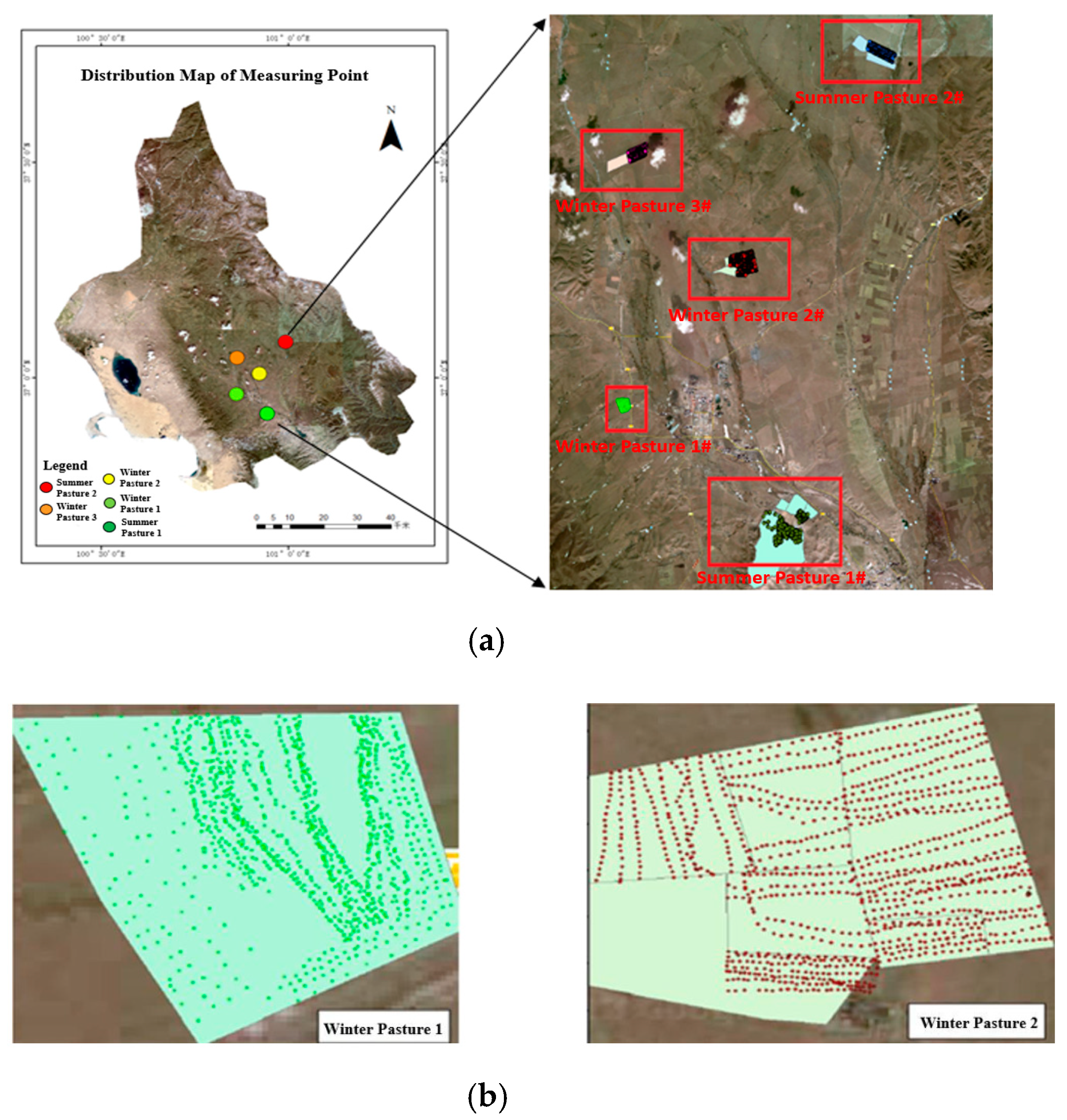
2.1. System Overview and Experiment Data
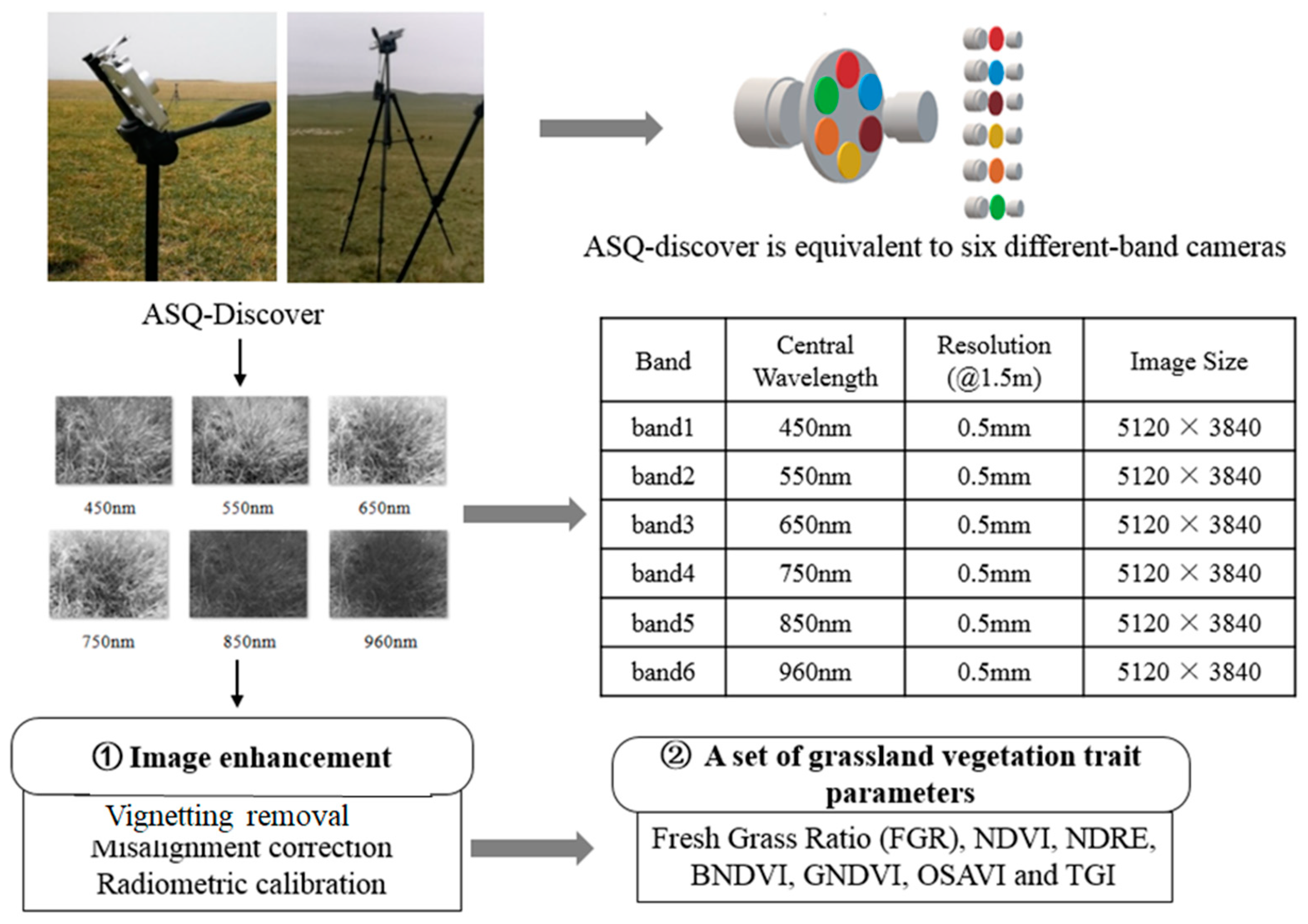
2.2. Image Processing
2.2.1. Vignetting Removal
2.2.2. Interband Misalignment Correction
2.2.3. Radiometric Calibration
2.3. A Set of Spectral Traits of Vegetation
2.3.1. Selecting Vegetation Indices
2.3.2. Estimating Fresh Grass Ratio
3. Results
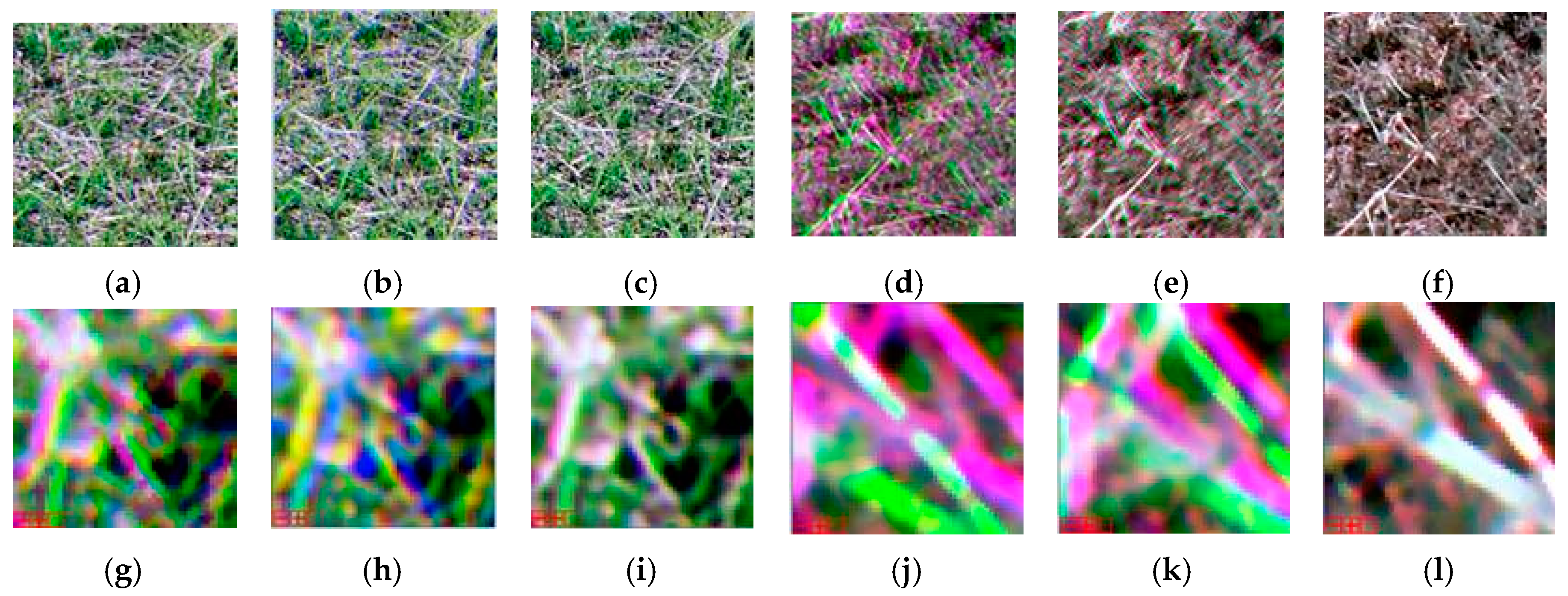
3.1. Vignetting Removal and Misalignment Correction
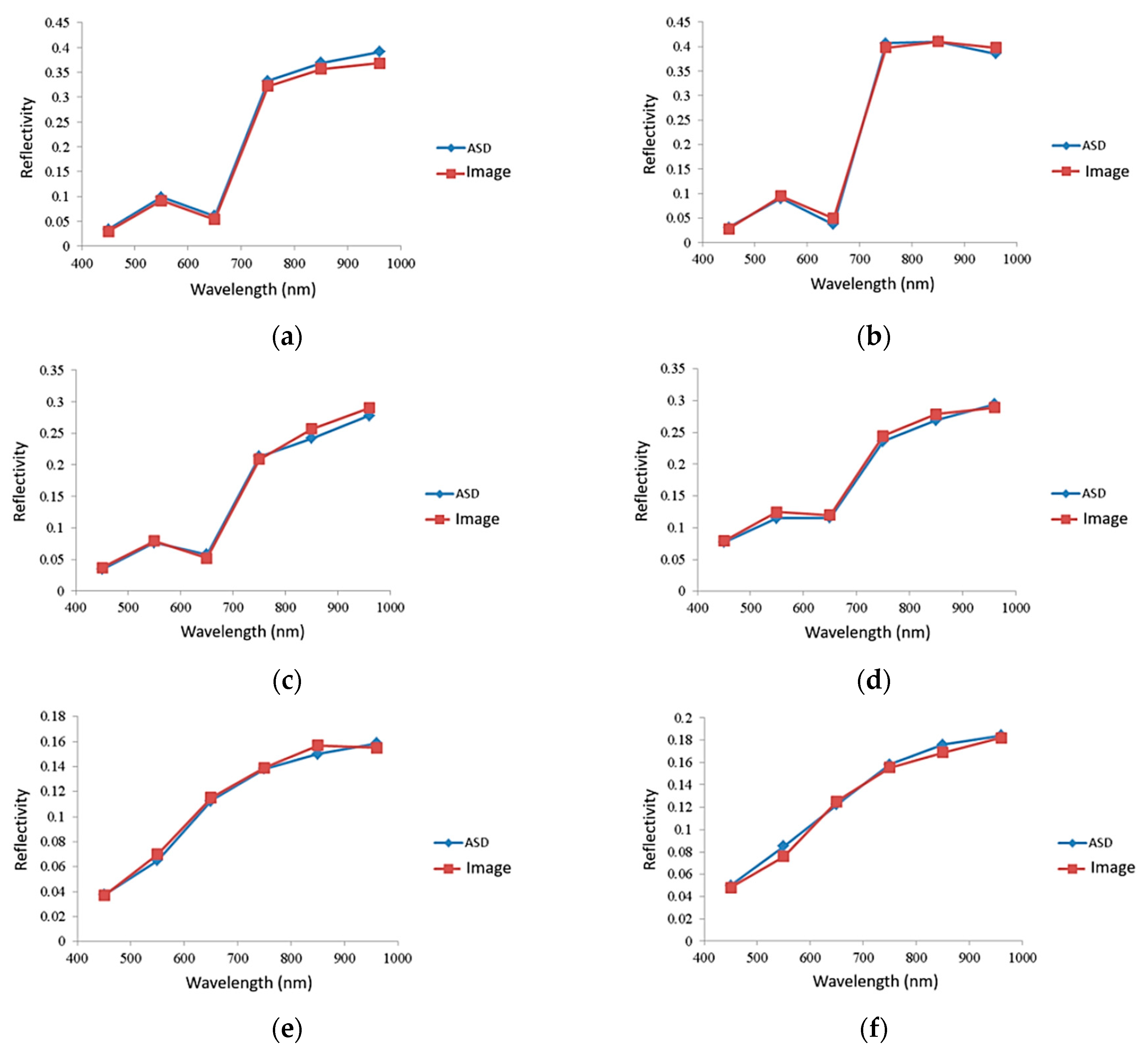
3.2. Radiometric Calibration
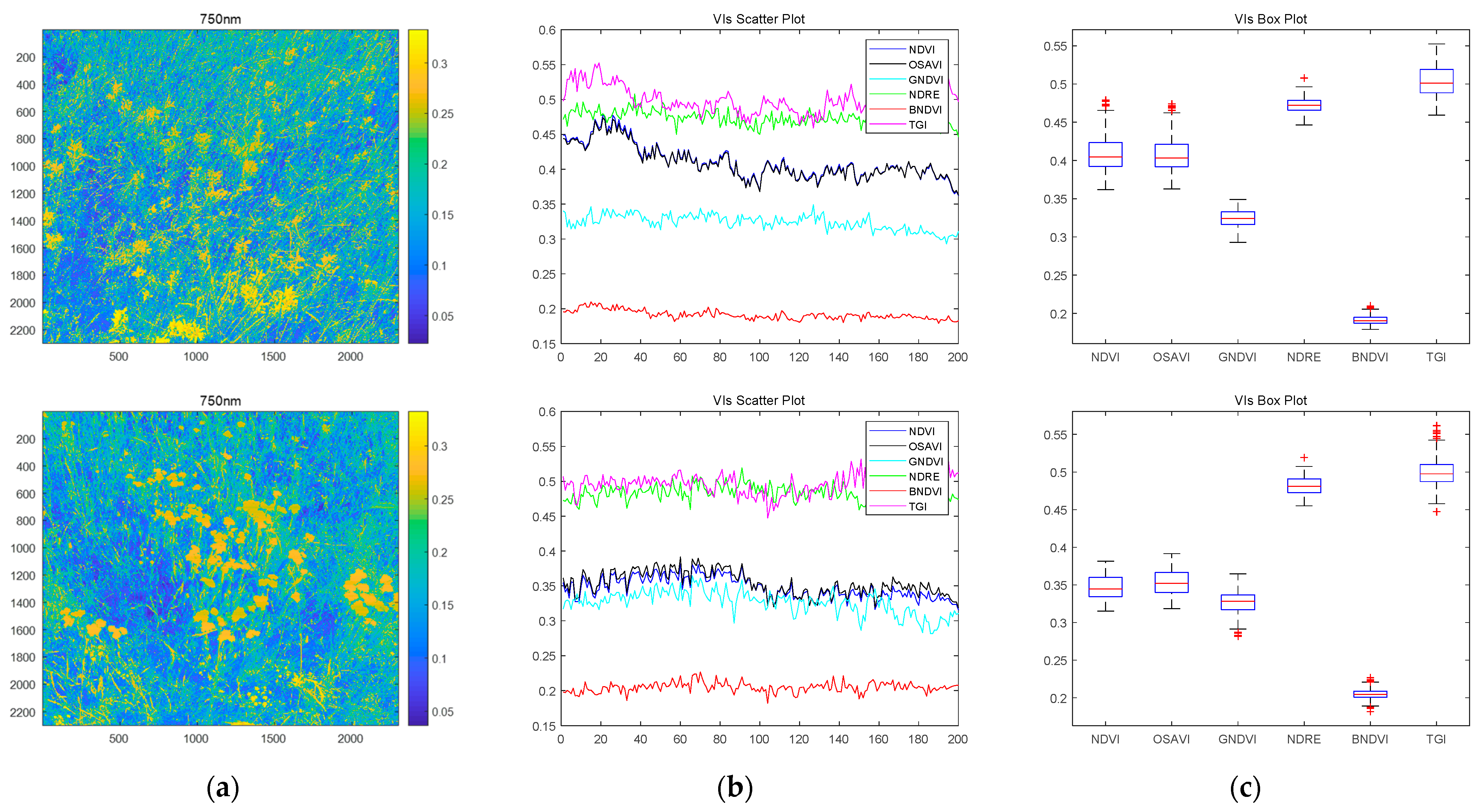
3.3. Visualization of the Selected Vegetation Indices at Quadrat Level
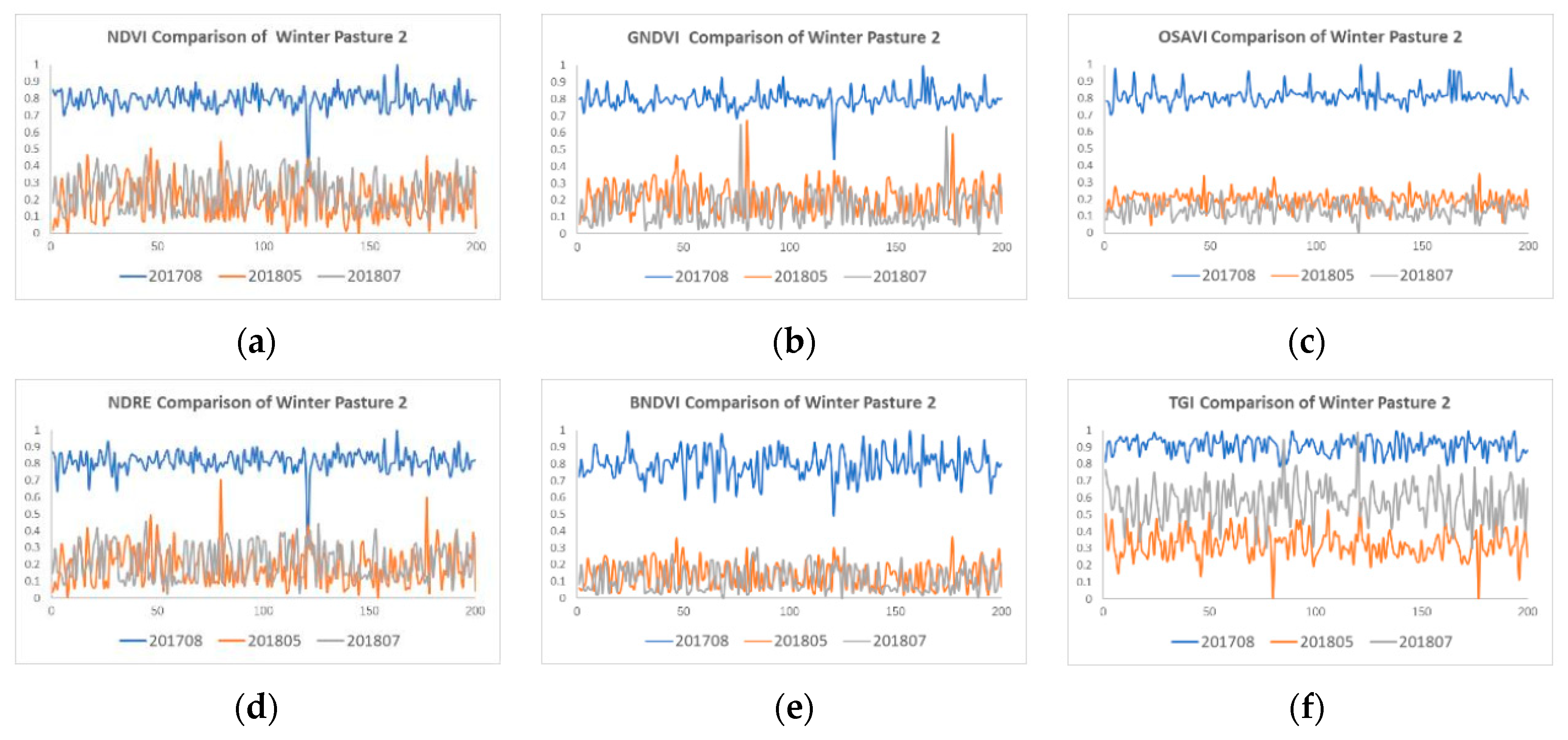
3.4. An Analysis of the Selected Vegetation Indices at Pasture Level
3.5. Fresh Grass Ratio
4. Discussion
5. Conclusions
Author Contributions
Funding
Acknowledgments
Conflicts of Interest
References
- Capolupo, A.; Kooistra, L.; Berendonk, C.; Boccia, L.; Suomalainen, J. Estimating plant traits of grasslands from UAV-acquired hyperspectral images: A comparison of statistical approaches. ISPRS Int. J. Geo Inf. 2015, 4, 2792–2820. [Google Scholar] [CrossRef]
- Homolová, M.E.; Schaepman, P.; Lamarque, J.G.; de Bello Clevers, F.; Thuiller, W.; Lavorel, S. Comparison of remote sensing and plant trait-based modelling to predict ecosystem services in subalpine grasslands. Ecosphere 2014, 5, 1–29. [Google Scholar] [CrossRef]
- Pullanagari, R.R.; Kereszturi, G.; Yule, I. Integrating airborne hyperspectral, topographic, and soil data for estimating pasture quality using recursive feature elimination with random forest regression. Remote. Sens. 2018, 10, 1117. [Google Scholar] [CrossRef] [Green Version]
- Zhang, A.; Guo, C.; Yan, W. Improving remote sensing estimation accuracy of pasture crude protein content by interval analysis. Trans. Chin. Soc. Agric. Eng. (Trans. CSAE) 2018, 34, 149–156. [Google Scholar]
- Zhang, A.; Yan, W.; Guo, C. Inversion model of pasture crude protein content based on hyperspectral image. Trans. Chin. Soc. Agric. Eng. (Trans. CSAE) 2018, 34, 188–194. [Google Scholar]
- Thenkabail, P.S.; Lyon, J.G. Hyperspectral Remote Sensing of Vegetation; CRC Press: Boca Raton, FL, USA, 2016. [Google Scholar]
- Lopatin, J.; Fassnacht, F.E.; Kattenborn, T.; Schmidtlein, S. Mapping plant species in mixed grassland communities using close range imaging spectroscopy. Remote. Sens. Environ. 2017, 201, 12–23. [Google Scholar] [CrossRef]
- Mccann, C.; Repasky, K.S.; Lawrence, R.; Powell, S. Multi-temporal mesoscale hyperspectral data of mixed agricultural and grassland regions for anomaly detection. Isprs. J. Photogramm. Remote. Sens. 2017, 131, 121–133. [Google Scholar] [CrossRef]
- Neumann, C.; Förster, M.; Kleinschmit, B.; Itzerott, S. Utilizing a PLSR-Based Band-Selection Procedure for Spectral Feature Characterization of Floristic Gradients. IEEE J. Sel. Top. Appl. Earth Obs. Remote. Sens. 2016, 9, 1–15. [Google Scholar] [CrossRef]
- Gutiérrez, S.; Wendel, A.; Underwood, J. Ground based hyperspectral imaging for extensive mango yield estimation. Comput. Electron. Agric. 2019, 157, 126–135. [Google Scholar] [CrossRef]
- Chebrolu, N.; Lottes, P.; Schaefer, A.; Winterhalter, W.; Burgard, W.; Stachniss, C. Agricultural robot dataset for plant classification, localization and mapping on sugar beet fields. Int. J. Robot. Res. 2017, 36, 1045–1052. [Google Scholar] [CrossRef] [Green Version]
- Rebetzke, G.J.; Jimenezberni, J.A.; Bovill, W.D.; Deery, D.M.; James, R.A. High-throughput phenotyping technologies allow accurate selection of stay-green. J. Exp. Bot. 2016, 67, 4919–4924. [Google Scholar] [CrossRef] [PubMed] [Green Version]
- Fern, R.R.; Foxley, E.A.; Bruno, A.; Morrison, M.L. Suitability of NDVI and OSAVI as estimators of green biomass and coverage in a semi-arid rangeland. Ecol. Indic. 2018, 94, 16–21. [Google Scholar] [CrossRef]
- Hill, M.J. Vegetation index suites as indicators of vegetation state in grassland and savanna: An analysis with simulated SENTINEL 2 data for a North American transect. Remote. Sens. Environ. 2013, 137, 94–111. [Google Scholar] [CrossRef]
- Behmann, J.; Acebron, K.; Emin, D.; Bennertz, S.; Matsubara, S.; Thomas, S.; Bohnenkmp, D.; Kuska, T.M.; Mahlein, A.K.; Rascher, U.; et al. Specim IQ: Evaluation of a New, Miniaturized Handheld Hyperspectral Camera and Its Application for Plant Phenotyping and Disease Detection. Sensors 2018, 18, 441. [Google Scholar] [CrossRef] [Green Version]
- Ma, Z.; Mao, Y.; Liang, G.; Liu, C. Smartphone-Based Visual Measurement and Portable Instrumentation for Crop Seed Phenotyping. IFAC Pap. 2016, 49, 259–264. [Google Scholar]
- Drew, M.S.; Finlayson, G.D. Analytic solution for separating spectra into illumination and surface reflectance components. J. Opt. Soc. Am. A 2017, 2, 294–303. [Google Scholar] [CrossRef] [Green Version]
- Khanna, R.; Sa, I.; Nieto, J.; Siegwart, R. On field radiometric calibration for multispectral cameras. In Proceedings of the 2017 IEEE International Conference on Robotics and Automation (ICRA), Singapore, 29 May–3 June 2017; pp. 6503–6509. [Google Scholar] [CrossRef]
- Aasen, H.; Burkart, A.; Bolten, A.; Bareth, G. Generating 3D hyperspectral information with lightweight UAV snapshot cameras for vegetation monitoring: From camera calibration to quality assurance. ISPRS J. Photogramm. Remote. Sens. 2017, 108, 245–259. [Google Scholar] [CrossRef]
- Ahmed, E.; Rose, J. The effect of LUT and cluster size on deep-submicron FPGA performance and density. IEEE Trans. Very Large Scale Integr. (VLSI) Syst. 2000, 12, 288–298. [Google Scholar] [CrossRef] [Green Version]
- Jhana, J.; Raua, J.; Huang, C. Band-to-band registration and ortho-rectification of multilens/multispectral imagery: A case study of MiniMCA-12 acquired by a fixed-wing UAS. ISPRS J. Photogramm. Remote. Sens. 2016, 114, 66–77. [Google Scholar] [CrossRef]
- Brauers, J.; Aach, T. Geometric Calibration of Lens and Filter Distortions for Multispectral Filter-Wheel Cameras. IEEE Trans. Image Process. 2011, 20, 496–505. [Google Scholar] [CrossRef]
- Li, H.; Zhang, A.; Hu, S. A multispectral image creating method for a new airborne four-camera system with different bandpass filters. Sensors 2015, 15, 17453–17469. [Google Scholar] [CrossRef] [PubMed] [Green Version]
- Zhang, A.; Li, H. A Lateral Strip Fast Splicing Method Without Shadows for Aerial Video Images. Chinese Patent No. 201511025377.3, 2 November 2018. [Google Scholar]
- Zhang, A.; Li, H. Multispectral Registration and Combination Software. Chinese Software Copyright No. 2015SR00768, 14 January 2015. [Google Scholar]
- Guo, Y.; Senthilnath, J.; Wu, W.; Zhang, X.; Zeng, Z.; Huang, H. Radiometric Calibration for Multispectral Camera of Different Imaging Conditions Mounted on a UAV Platform. Sustainability 2019, 11, 978. [Google Scholar] [CrossRef] [Green Version]
- W M Baugh, D.P.G. Empirical proof of the empirical line. Int. J. Remote. Sens. 2008, 29, 665–672. [Google Scholar] [CrossRef]
- Available online: https://en.wikipedia.org/wiki/Vegetation_Index (accessed on 16 August 2021).
- Zhang, H.; Ma, J.; Chen, C.; Tian, X. NDVI-Net: A fusion network for generating high-resolution normalized difference vegetation index in remote sensing. ISPRS J. Photogramm. Remote. Sens. 2020, 168, 182–196. [Google Scholar] [CrossRef]
- Pei, F.; Wu, C.; Liu, X.; Li, X.; Yang, K.; Zhou, Y.; Wang, K.; Xu, L.; Xia, G. Monitoring the vegetation activity in China using vegetation health indices. Agric. For. Meteorol. 2018, 248, 215–227. [Google Scholar] [CrossRef]
- Baluja, J.; Diago, M.P.; Balda, P.; Zorer, R.; Meggio, F.; Morales, F.; Tardguila, J. Assessment of vineyard water status variability by thermal and multispectral imagery using an unmanned aerial vehicle (UAV). Irrig. Sci. 2012, 30, 511–522. [Google Scholar] [CrossRef]
- Ihuoma, S.O.; Madramootoo, C.A. Crop reflectance indices for mapping water stress in greenhouse grown bell pepper, Agricultural Water Management. Agric. Water Manag. 2019, 219, 49–58. [Google Scholar] [CrossRef]
- Available online: https://eos.com/industries/agriculture/ndre (accessed on 16 August 2021).
- Fernandez-Gallego, J.A.; Kefauver, S.C.; Vatter, T.; Gutiérrezd, N.A.; NietoTaladrize, M.T.; Araus, J.L. Low-cost assessment of grain yield in durum wheat using RGB images. Eur. J. Agron. 2019, 105, 146–156. [Google Scholar] [CrossRef]
- Kleed, A.; Gypser, S.; Herppich, W.B.; Bader, G.; Veste, M. Identification of spatial pattern of photosynthesis hotspots in moss- and lichen-dominated biological soil crusts by combining chlorophyll fluorescence imaging and multispectral BNDVI images. Pedobiologia 2018, 68, 1–11. [Google Scholar] [CrossRef] [Green Version]
- Available online: https://www.soft.farm/en/blog/vegetation-indices-ndvi-evi-gndvi-cvi-true-color-140 (accessed on 16 August 2021).
- Aguilar, C.; Zinnert, J.C.; Polo, M.J.; Young, D.R. NDVI as an indicator for changes in water availability to woody vegetation. Ecol. Indic. 2012, 23, 290–300. [Google Scholar] [CrossRef]
- Chen, H.; Wang, P.; Li, J.; Zhang, J.; Zhong, L. Canopy Spectral Reflectance Feature and Leaf Water Potential of Sugarcane Inversion. Phys. Procedia 2012, 25, 595–600. [Google Scholar] [CrossRef] [Green Version]
- Tucker, C.J. Cover Maximum normalized difference vegetation index images for sub-Saharan Africa for 1983–1985. Int. J. Remote. Sens. 1986, 7, 1383–1384. [Google Scholar] [CrossRef]
- Steven, M.D. The sensitivity of the OSAVI vegetation index to observational parameters. Remote. Sens. Environ. 1998, 63, 49–60. [Google Scholar] [CrossRef]
- Rondeaux, G.; Steven, M.; Baret, F. Optimization of Soil-Adjusted Vegetation Indices. Remote. Sens. Environ. 1996, 55, 95–107. [Google Scholar] [CrossRef]
- Shanahan, J.F.; Schepers, J.S.; Francis, D.D.; Varvel, G.E.; Wilhelm, W.W.; Tringe, J.M.; Schlemmer, M.R.; Major, D.J. Use of Remote-Sensing Imagery to Estimate Corn Grain Yield. Agron. J. 2001, 93, 583. [Google Scholar] [CrossRef] [Green Version]
- Li, F.; Miao, Y.; Feng, G.; Yuan, F.; Yue, S.; Gao, X.; Liu, Y.; Liu, B.; Ustin, S.L.; Chen, X.; et al. Improving estimation of summer maize nitrogen status with red edge-based spectral vegetation indices. Field Crop. Res. 2014, 157, 111–123. [Google Scholar] [CrossRef]
- Hunt, E.R., Jr.; Doraiswamy, P.C.; McMurtrey, J.E.; Daughtry, C.S.T.; Perry, E.M.; Akhmedov, B. A visible band index for remote sensing leaf chlorophyll content at the canopy scale. Int. J. Appl. Earth Obs. Geoinf. 2013, 21, 103–112. [Google Scholar] [CrossRef] [Green Version]
- Wu, G.; Miller, N.D.; Leon, N.; Kaeppler, S.M.; Spalding, E.P. Predicting Zea mays Flowering Time, Yield, and Kernel Dimensions by Analyzing Aerial Images. Front. Plant Sci. 2019, 10, 12–51. [Google Scholar] [CrossRef] [Green Version]
- Anche, M.T.; Kaczma, N.S.; Morales, N.; Clohessy, J.W.; Ilut, D.C.; Gore, M.A.; Robbins, K.R. Temporal covariance structure of multi spectral phenotypes and their predictive ability for end of season traits in maize. Theor. Appl. Genet. 2020, 133, 2853–2868. [Google Scholar] [CrossRef] [PubMed]
- Meyer, G.E.; Neto, J.C. Verification of color vegetation indices for automated crop imaging applications. Comput. Electron. Agric. 2008, 63, 282–293. [Google Scholar] [CrossRef]
- Hamuda, E.; Glavin, M.; Jones, E. A survey of image processing techniques for plant extraction and segmentation in the field. Comput. Electron. Agric. 2016, 125, 184–199. [Google Scholar] [CrossRef]
- Zhang, D.; Mansaray, L.R.; Jin, H.; Han, S.; Kuang, Z.; Huang, J. A universal estimation model of fractional vegetation cover for different crops based on time series digital photographs. Comput. Electron. Agric. 2018, 151, 93–103. [Google Scholar] [CrossRef]
- Kitić, G.; Tagarakis, A.; Cselyuszka, N.; Panić, M.; Birgermajer, S.; Sakulski, D.; Matović, J. A new low-cost portable multispectral optical device for precise plant status assessment. Comput. Electron. Agric. 2019, 162, 300–308. [Google Scholar] [CrossRef]
- Mishra, P.; Asaari, M.S.M.; Herrero-Langreo, A.; Lohumi, S.; Diezma, B.; Scheunders, P. Close range hyperspectral imaging of plants: A review. Biosyst. Eng. 2017, 164, 49–67. [Google Scholar] [CrossRef]
- Iqbal, F.; Lucieer, A.; Barry, K. Simplified radiometric calibration for UASmounted multispectral sensor. Eur. J. Remote Sens. 2018, 51, 301–313. [Google Scholar] [CrossRef]
- MicaSense Multispectral Sensors. Available online: https://micasense.com (accessed on 16 August 2021).
- Tetracam Micro-MCA Multispectral Camera Array. Available online: https://tetracam.com/Products-Micro_MCA.htm (accessed on 16 August 2021).




| Name | Area | Name | Area |
|---|---|---|---|
| Summer pasture #1 | 0.72 × 3 = 2.16 km2 | Winter pasture #2 | 0.82 × 3 = 2.46 km2 |
| Summer pasture #2 | 0.43 × 1 = 0.43 km2 | Winter pasture #3 | 0.34 × 1 = 0.34 km2 |
| Winter pasture #1 | 0.27× 3 = 0.81 km2 |
| VI | Description | Formula | References |
|---|---|---|---|
| NDVI | Normalized Difference Vegetation Index | [39] | |
| OSAVI | Optimized Soil-Adjusted Vegetation Index | [40,41] | |
| GNDVI | Green Normalized Difference Vegetation Index | [42] | |
| NDRE | Normalized Difference Red Edge | [43] | |
| BNDVI | Blue Normalized Difference Vegetation Index | [35] | |
| TGI | Triangular Greenness Index | [44] |
| Method | 550 nm | 650 nm | 750 nm | 850 nm | 960 nm |
|---|---|---|---|---|---|
| The whole image matching | 5.8642 | 4.3547 | 6.1286 | 8.1856 | 10.6536 |
| Image block matching | 2.4385 | 2.7864 | 3.3127 | 5.4154 | 5.7841 |
| Band | Calibration Equation | R2 |
|---|---|---|
| Band1 (450 nm) | 0.9493 | |
| Band2 (550 nm) | 0.9295 | |
| Band3 (650 nm) | 0.9398 | |
| Band4 (750 nm) | 0.9312 | |
| Band5 (850 nm) | 0.9414 | |
| Band6 (960 nm) | 0.9208 |
| Wavelength (nm) | 450 | 550 | 650 | 750 | 850 | 960 |
|---|---|---|---|---|---|---|
| MPAE (%) | 6.35 | 6.89 | 10.65 | 2.19 | 17.62 | 3.18 |
Publisher’s Note: MDPI stays neutral with regard to jurisdictional claims in published maps and institutional affiliations. |
© 2021 by the authors. Licensee MDPI, Basel, Switzerland. This article is an open access article distributed under the terms and conditions of the Creative Commons Attribution (CC BY) license (https://creativecommons.org/licenses/by/4.0/).
Share and Cite
Zhang, A.; Hu, S.; Zhang, X.; Zhang, T.; Li, M.; Tao, H.; Hou, Y. A Handheld Grassland Vegetation Monitoring System Based on Multispectral Imaging. Agriculture 2021, 11, 1262. https://doi.org/10.3390/agriculture11121262
Zhang A, Hu S, Zhang X, Zhang T, Li M, Tao H, Hou Y. A Handheld Grassland Vegetation Monitoring System Based on Multispectral Imaging. Agriculture. 2021; 11(12):1262. https://doi.org/10.3390/agriculture11121262
Chicago/Turabian StyleZhang, Aiwu, Shaoxing Hu, Xizhen Zhang, Taipei Zhang, Mengnan Li, Haiyu Tao, and Yan Hou. 2021. "A Handheld Grassland Vegetation Monitoring System Based on Multispectral Imaging" Agriculture 11, no. 12: 1262. https://doi.org/10.3390/agriculture11121262
APA StyleZhang, A., Hu, S., Zhang, X., Zhang, T., Li, M., Tao, H., & Hou, Y. (2021). A Handheld Grassland Vegetation Monitoring System Based on Multispectral Imaging. Agriculture, 11(12), 1262. https://doi.org/10.3390/agriculture11121262


