1. Introduction
Climate change is one of the most significant environmental and social challenges that humanity faces today. Climate change parameters such as, changing weather patterns, an increased frequency of extreme weather events, and rising temperatures, have led to reduced crop yields, crop failures, a loss of livestock, and increased soil erosion [
1,
2,
3,
4]. In Northeast India (NEI), this change in climate poses a significant risk to the agriculture and agroforestry sectors, which form the backbone of the region’s economy [
5]. This part of the country is also home to a large number of both urban and rural farmers who are highly dependent on agroforestry land use for their livelihoods. Climate change, along with the increasing frequency and intensity of abnormal weather events, exacerbates the vulnerabilities faced by the farmers as it has significant implications for food security, poverty, and overall sustainable development in the region [
6,
7,
8].
The Intergovernmental Panel on Climate Change (IPCC) emphasizes the importance of understanding and assessing climate risks to develop appropriate adaptation and mitigation strategies. This paper followed the present IPCC [
9] risk concept by segregating exposure from vulnerability estimation. Climate risk is a function of three dimensions: hazard, exposure, and vulnerability. It is the outcome of the interplay between climate-related hazards with the exposure and vulnerability of both human and natural systems. According to the Fifth Assessment Report of the IPCC (AR5), hazard refers to ‘the potential occurrence of a natural or human-induced physical event or trend or physical impact that may cause loss of life, injury, or other health impacts, as well as damage and loss of property, infrastructure, livelihoods, service provision, ecosystem and environmental resources. Exposure is ‘the presence of people, livelihoods, species or ecosystems, environmental functions, services and resources, infrastructure, or economic, social, or cultural assets in places and settings that could be adversely affected’ while, vulnerability is ‘the propensity or predisposition to be adversely affected’. It depends on both the sensitivity and the capacity of the system to adapt to climate variability and change [
10]. Data of these three dimensions can be a mixture of spatial and socio-economic indicators or of socioeconomic indicators alone [
11,
12].
Not all indicators are equally important in determining vulnerability, and some may be more relevant to certain regions or communities than others [
13]. For instance, the variations in capacity serve as a contributing factor to why communities facing similar levels of exposure may experience different impacts from a particular hazard [
14]. And therefore, indicators are selected based on either theoretical understandings of their association to vulnerability or based on statistical relationships [
15]. This paper utilizes the Shannon entropy method (SEM) for determining the weights of each indicator for every component. Other weighing methods used in vulnerability and risk assessment studies are the equal weight method [
16], spatial principal component analysis [
17], and the analytical hierarchy process [
18]. However, SEM has the advantage of being feasible [
19] and ensures that the weights assigned are proportional to the degree of diversity or variability among the criteria, which help prevents biases or inconsistencies in the decision-making process.
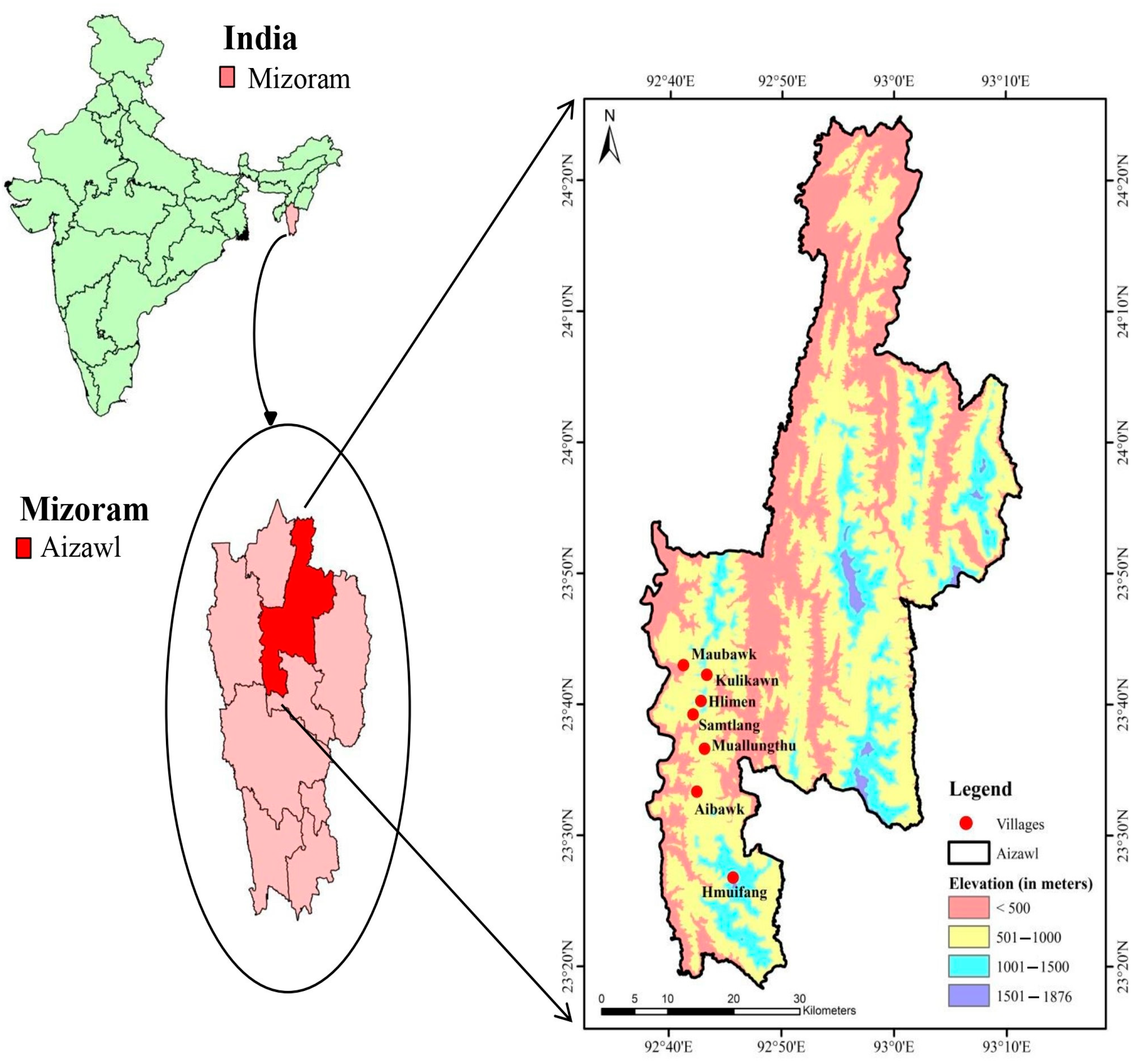
Climate change poses multiple threats to rural and urban agroforestry farmers. Rural farmers are often exposed to natural disasters and less accessible to resources and infrastructure [
20,
21]. Urban areas, while generally better equipped, still face challenges such as heatwaves and rapid urbanization [
22]. It is crucial to understand the association between urban and rural areas with altitude and agglomeration for comprehending the geographical distribution of human settlements and their vulnerability to climate change impacts. Communities inhabiting high-altitude areas are deemed susceptible to climate change due to their exposure to early signs of climate change, the sensitivity of local resources, and limited access to adaptive measures [
23]. Additionally, the Aizawl District Management Plan [
24] identified high incidents of hazards such as landslide, earthquake, wind and cyclones, and flood to be decreasing from Aizawl headquarter further south towards Aibawk block.
The study of climate-induced risks in agroforestry is of paramount importance in the face of a changing climate. While traditionally, rural agroforestry farmers have been at the forefront of climate vulnerability and risk assessments [
25,
26,
27], it is equally imperative to extend this scrutiny to urban agroforestry managers. Climate change affects both rural and urban environments, and understanding the unique challenges faced by the agroforestry managers in these areas is essential for effective mitigation and adaptation strategies [
28]. Furthermore, it is also necessary to address if change in the altitude and distance of agroforestry households from Aizawl headquarter is associated with their risk index, based on which we hypothesised that the risk index of agroforestry households increases with altitude while it decreases with the distance from Aizawl headquarter. The current research is essential for a holistic understanding of climate-induced risks to ensure comprehensive resilience strategies that address the diverse needs of urban and rural agroforestry, knowledge sharing for more effective and climate-resilient agroforestry practices, and inclusive policies that can better equip managers to adapt to the challenges posed by the changing climate [
29,
30,
31]. Therefore, the objective of this study is to investigate the influence of distance from Aizawl headquarter on the climate-induced risk of agroforestry households in Aizawl district.
4. Discussion
4.1. Demographic Differences
Education is a crucial and fundamental component needed to raise the standard of human resources. It is underlined that education improves the quality and, consequently, the productivity of the labour force and quickens the rate of knowledge accumulation within society [
49]. The results provided information on the distribution of HoFs by gender, level of education, and primary occupations within the communities. Understanding these elements is essential for developing development interventions that take gender into account, making the most of the knowledge and experience of older HoFs, and creating plans for economic growth and diversification in the Mizo communities in Aizawl. A study on education and human development in Mizoram (NEI) also found that employment and standard of living increased with higher education levels and professional degrees such as management and vocational studies [
50]. Studies on gender distribution and literacy rates can be valuable for understanding and addressing gender-based disparities in education and opportunities. The household size and food availability in Kulikawn defines the livelihood security at the basic level [
51].
4.2. Land Resources
‘Land resources’ emphasizes how different villages have diverse land availability, water management, and land-use practices. Muallungthu has the most varied land-use components, making home gardens essential for food security and generating money. Due to lower land holdings, Kulikawn has a large percentage of irrigated area under various land uses. In both urban and rural areas, the traditional land-use patterns are changing in favour of commercially successful plantations. This change may elevate households’ livelihood statuses, but at the cost of great biodiversity loss and soil degradation [
52].
4.3. Risk Dimensions
Risk studies are conducted as a prerequisite in making policies to prevent further degradation due to environmental crises [
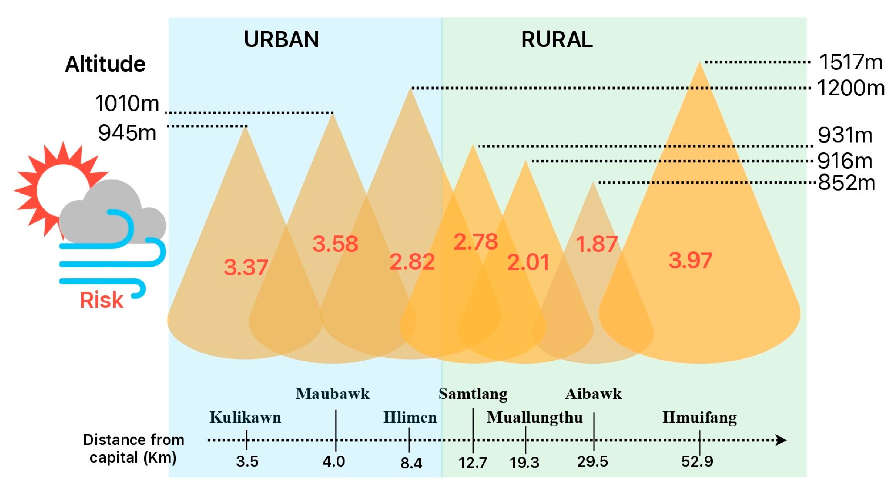
53]. We derived the risk index for the seven villages and ranked them accordingly as Hmuifang > Maubawk > Kulikawn > Hlimen > Samtlang > Muallungthu > Aibawk. This finding was in agreement with our hypothesis that the risk index of agroforestry households increases with altitude while it decreases with the distance from Aizawl headquarter.
Risk is a relative concept; hence, the risk ranking based on vulnerability indices is a comparison of different villages. Consequently, it does not indicate that villages with higher risk index values are inherently vulnerable and dangerous places to live; rather, it means that they are relatively riskier than villages with lower index values. Furthermore, when employing an indicator-based approach to assess risk, it is important to acknowledge that additional or alternative indicators can also be used for evaluating the risk within the same study area. Therefore, the aforementioned risk indicators or drivers are not exclusive or consistent across all urban and rural households within the represented villages, emphasising the presence of other diverse factors influencing risk.
4.4. Climate Change Hazard and Exposure
Each hazard is characterised by its probability, location, magnitude, and frequency. Rapid urban population growth strains the capacity of developing countries to cope with extreme events, with smaller cities and rural communities being potentially more vulnerable than megacities (United Nations Humans Settle programme [
54]). Past climate anomalies (from the questionnaire survey) and future projections (SSP2-4.5, 2040–2059) of Aizawl district revealed precipitation and temperature to be of great concern (
Figures S1 and S2).
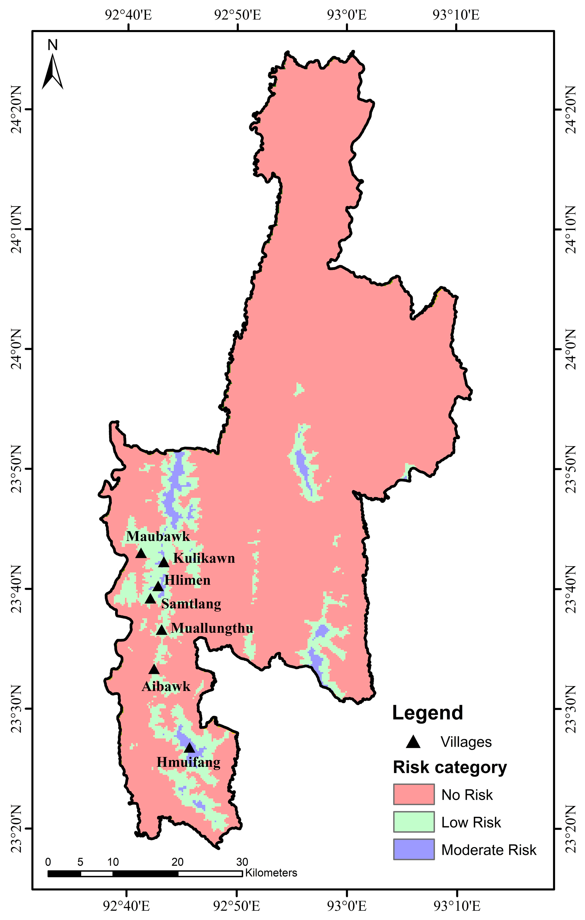
Exposure denotes the presence of assets, people, and ecosystems in areas where climate hazards could have an adverse effect. A loss of green space in urban areas can exacerbate exposure to extreme climate events by affecting runoff, urban heat island mitigation, and biodiversity [
55]. It is essential to invest in infrastructure improvements, early warning systems, and disaster risk reduction strategies to mitigate the impact of hazards in Kulikawn and Samtlang villages. Community engagement and awareness campaigns can also play a vital role in enhancing local resilience to such hazards. To address the problem of diseases and pests on productivity, integrated pest management strategies, including the use of environmentally friendly pesticides, biological control methods, and cultural practices should be implemented. Additionally, training and capacity building of local farmers in pest identification and management can contribute to sustainable agricultural practices.
Finally, managing climatic exposure to crop variety is crucial, particularly for the villages of Muallungthu and Hlimen. The types of crops cultivated in rural households depend on the accessibility, availability, and adaptability of seed varieties. Promoting climate-resilient crop varieties, improving irrigation systems, and implementing climate-smart agricultural practices can help these villages adapt to the changing climate and maintain their agricultural productivity.
4.5. Vulnerability
Addressing vulnerability, hazards, and exposure to existing climatic variability is the first step in mitigating the risk posed by the effects of climate change. However, in practice, hazards and exposure present limited prospects and manageability since it is not viable to move or remove an entire area or system from climate exposure. Vulnerability provides greater manageability and potential for reduction by improving adaptive capacity and addressing the sensitivity of systems to climate change or variability [
12]. Therefore, it is more practical and impactful to focus on addressing vulnerability rather than dealing with hazards and exposure.
Risk assessment helps in selecting adaptation measures based on the assessment of the drivers of vulnerability. Drivers of vulnerability are indicators used for vulnerability assessment that are expressed as sensitivity or a lack of adaptive capacity. Our study on these drivers for different villages suggested that biophysical and socioeconomic features such as cultivation schedule, agroforestry and horticulture output, land holdings, loan availability, changes in cultivation practice, areas under irrigation, and the number of farmers depending on agriculture as their primary source of income are the dominant drivers of vulnerability.
4.6. Risk to Urban and Rural Households
There is no simple relationship between exposure and vulnerability to climate extremes in urban and rural environments, as climate risks can be ameliorated or exacerbated by positive or negative adaptation processes and outcomes in either context [
22]. Despite Hmuifang village being the farthest from Aizawl headquarters, it faces significant climate risks. This is supplemented by the region’s low productivity, small land holdings, and fewer household members in farming practices. Furthermore, adaptive mechanisms such as health, banking, and training facilities were also unavailable in the area. Households with institutional facilities are better-adapted to climate risks and are more likely to practice climate smart agriculture [
56]. A study on the vulnerability of different agroforestry systems (AFS) in Northeast India also found Hmuifang village to be highly vulnerable [
57]. The region is also associated with strong wind, steep slopes, a scarcity of water, and winter drought, which renders it highly susceptible to the risk of climate change. This study also found that households with agroforestry practice in higher elevations have greater risk than do lower elevation households. In addition, Hmuifang, located in the highest elevation of all the studied villages, also suffered with the highest risk, which corresponds with the findings of a study conducted on the upper Himalayan region where the socio-economic vulnerability of the people living in hills with an elevation of 1000 m and above showed higher sensitivity and vulnerability to climate change [
39].
Rural livelihoods are heavily reliant on the environment and natural resources, and extreme climate events can significantly impact the agricultural sector [
58]. On the other hand, accelerated urbanization in Aizawl district has resulted in a decrease in land holding size, a decrease in agricultural production, and an increase in the practice of monocropping. Thus, despite having better urban amenities, the urban farmers were found to be more susceptible to climate change risks.
Urban and rural areas are closely connected, with each depending on the other for resources, employment, and services. Climate-related variability and extremes can affect these relationships. For marginal farmers, climate-led economic uncertainty often influences agricultural households’ decision-making. The coping mechanisms post-disaster may help poor households regain assets and resist extreme poverty, but long-term adaptation strategies to lift them out of poverty remain elusive for most.
4.7. Policy Formulation
Improving agriculture’s ability to withstand climate change requires significant government involvement. This can be achieved through two key strategies: first, the development of context-specific policies and programs, coupled with effective implementation through improved coordination across various administrative levels, ensuring a seamless flow of information, knowledge, and resources to farmers; second, fostering convergence among diverse programs managed by various ministries and departments to optimize the efficient and sustainable allocation of financial and human resources [
57]. In this study, we found a few components that require priority intervention through government planning and policies. A brief explanation of these key components along with the target village is given in
Supplementary Table S6.
The climate action plans developed by the Indian Government under the National Action Plan on Climate Change (NAPCC) and district-level contingency plans established by the Indian Council of Agriculture Research (ICAR) have demonstrated limited effectiveness. Our study revealed that respondents in the examined villages did not receive the expected assistance during crises, likely due to a lack of coordination at administrative levels below the state, district, block, and village. To enhance the efficacy of these plans, it is imperative that village-level institutions, such as village councils, are effectively coordinated to facilitate the dissemination of adaptation technologies, funding and skill development facilities.
5. Conclusions
The risk index of agroforestry households increases with the altitude of the villages while it decreases as the distance of these villages from Aizawl headquarter extends. The risk analysis of the hazard, exposure, and vulnerability components affecting farmers’ ability to cope with the changing climate in these villages provides important insights that can inform policy and intervention strategies. The findings reveal that every village undergoes a different set of difficulties, suggesting that a one-size-fits-all strategy may not be successful in resolving these problems. Hence, it is essential to create focused treatments that take into account the unique risk factors affecting the sustainability of each village’s livelihood.
Furthermore, given the persistent climate hazards predicted for the next several decades, including rising temperatures and reduced rainfall, it is essential to advocate for policies promoting climate-smart agriculture. Complementary initiatives such as the agriculture credit scheme and skill development programs should be integrated into these efforts. It is also worth noting that despite a high literacy rate in the studied villages, there remains a concerning dropout rate among youths. Therefore, future policy endeavours should also incorporate innovative schemes designed to attract and encourage dropout youths to pursue higher education, aligning with our broader goals of sustainable development and resilience to climate change.


 ,
, 
