1. Introduction
Through photosynthesis and surface albedo processes, land vegetation cover plays an important role in regulating the carbon cycle in terrestrial ecosystems [
1]. Vegetation cover also plays a key role in the economic structure and development of a country or region, particularly in arid and semi-arid areas, where agricultural and livestock production are the main economic activities [
2,
3]. There are several factors that affect land vegetation, including natural effects (e.g., climate) and human activities [
4]. The intensification of human activities and urbanisation have put significant pressure on nature, thereby leading to shortages of natural resources worldwide. Seto et al., 2012 [
5] calculated that urbanisation will disrupt 5% of global habitat, biomass, and carbon storage by 2030. A more recent study discovered a high correlation between the vegetation index and the building index, thereby implying that urbanisation has an indirect impact on vegetation in Dhofar’s mountains, plains, and coastal areas [
6]. The study also found, using a linear methods tool, that urbanisation was responsible for a decline of 18.5% in other plant species found in mountainous areas. Prior studies [
7,
8] have primarily used linear correlations to illustrate the influence of human activities on vegetation change. Climate change has caused a reduction in plant cover in numerous places around the world, which has had major economic effects and significant losses in biodiversity and the ecosystem [
9]. For example, drought afflicted an average of 21 million hectares in China between 1949 and 2000, thereby resulting in a loss of over 60 million tons of grain in 2000, the largest documented loss in 51 years in the country [
10]. A recent study in the United States found that global warming had already contributed considerably to the loss of national-level crop insurance to the tune of USD 27.0 billion between 1991 and 2017 [
11]. However, a deeper knowledge of vegetation changes and their response to climatic influences is crucial for forecasting future climatic change and vegetation growth and health pattern conditions [
12].
Numerous studies have found that global change has had a significant impact on the normalised difference vegetation index (NDVI) worldwide [
13,
14,
15]. Furthermore, many of the studies conducted at regional levels to investigate the relationship between NDVI and climatic conditions revealed variations in the mechanisms underlying the response of vegetation to climate change due to differences in regions, vegetation characteristics, and study methods [
16]. For example, Liu et al. [
17] found that vegetation coverage has a high positive correlation with rainfall in the arid western parts of north-eastern Asia, whereas changes in NDVI—which are driven mainly by temperature—are less pronounced. Schultz et al. [
18] found that NDVI measurements on a global scale are not strongly associated with rainfall. However, only a few studies have been undertaken on the impact of climate change and its associated vulnerabilities in the Sultanate of Oman [
19,
20,
21]. For example, a study conducted to compare temperature and rainfall trends between 1980 and 2013 found that Oman was sensitive to climate change [
21]. According to the findings, the north of Oman (the non-monsoonal subregion) had the greatest statistically significant warming trends of 0.6 °C per decade
−1, whereas the lowest warming trend values were recorded over the monsoonal area of Dhofar and along the southeast coast (0.1 °C per decade
−1 in Salalah). In terms of total annual rainfall, the results revealed negative trends over Salalah station in southern Oman, with a negative trend of 10.8 mm per decade
−1, whereas Saiq station in northern Oman had a negative trend of 74.0 mm per decade
−1 [
21,
22]. Furthermore, there was a significant increase in tropical cyclone events in Oman between 2007 and 2021. Among these cyclones were Cyclone Gonu in 2007 [
23], cyclone Phet in 2010 [
24], Cyclone Mekunu in 2018 [
25], and Depression ARB01 in May 2020. Cyclone Mekunu hit the region (Dhofar) with over 500 mm of rain. It caused catastrophic flooding and had an impact on groundwater recharge as well [
25].
Despite numerous studies demonstrating global NDVI changes, few studies have been conducted on vegetation cover and NDVI values in response to climate change, particularly in the Dhofar governorate in southern Oman. Galletti et al. [
7] reported that between 1988 and 2013, there was a decline in the NDVI in Salalah’s coastal plain. However, each of the mechanisms used to scrutinise the relationships between the dependent (NDVI) and independent variables (climate, environmental, and human activities) discussed previously are traditional statistical methods, which occasionally might not fully reflect the complex relationships between NDVI and human, climatic, and situational influences in the study area. We contend that most current research on vegetation cover has concentrated solely on ecology, human activities, or control mechanisms. Because of the lack of an adequate network of monitoring stations, the unsuitability of small areas for cultivation, large areas that are unreachable and uninhabited, and a lack of personnel for effective database management and analysis, and a lack of short-term and specific weather data, analyses on these aspects to study the relationship between the NDVI and climatic factors—such as temperature and humidity—are limited in Oman. There has been very little research linking NDVI spatial and temporal distributions to human, environmental, and meteorological activities that promote its survival and development on a geographical and temporal scale. Understanding the distribution and affinity of the NDVI in terms of these variables, as well as data mapping, can play an important role in its control and management as well as in capacity planning. The data indicate that grazing activities and urbanisation are the principal drivers of these changes.
Thus, this study was carried out to analyse how vegetation in the Dhofar areas responded to climate change from 2016 to 2021 and to examine the spatiotemporal variation vegetation pattern using satellite datasets from Sentinel-2. We structured this study into two parts to fulfil these objectives. The first section of this study looks at individual climate parameters and their relationships with NDVIs. In the second phase of this study, we used more advanced predictive models and regression analytic approaches to investigate the combinations of climate, ecological, and human activity elements that are most conducive to vegetation cover survival. From 2016 to 2021, spatial regression methods were employed to investigate the effects of climate parameters such as air temperature, humidity, and rainfall on vegetation dynamics. To model and predict the interactions between the NDVI and temperature, humidity, rainfall, soil type, geology types, topographic wetness index (TWI), curvature, elevation, slope, aspect, distance to buildings, and distance to roads, Random Forest Regression (RFR) was utilised.
4. Discussion
The vegetation ecosystems in the Dhofar Governorate exhibit a series of spatiotemporal variations as a result of global climate change, which has a direct impact on the ecological environment. In this study, Sentinel-2 data, Proba-V remote sensing data, NDVI, weather station data, ERA5, and multiple regression and FBCR models were used to examine the impacts of climate, environments, and human activities factors on vegetation dynamics for the period from 2015 to 2021. In the first phase of this study, OLS was used to evaluate the spatial association between NDVI levels and climate parameters such as air temperature, humidity, and rainfall. In the second phase of this study, FBCR was used to model and predict the spatial correlations of combinations of climate, environment, human activities, and NDVI. Our analysis of the simulation of the ERA5 model data sets and meteorological observations of temperature and total rainfall from 2000 to 2021 indicated good performance and was generally rather satisfactory. Our findings are consistent with those of a previous study by Al-Sarmi et al. [
21], who found an increasing trend in air temperature between 1980 and 2013 in the northern region of the Sultanate of Oman (0.6 °C per decade
−1) and over the Dhofar Governorate (Salalah 0.1 °C per decade
−1). However, previous studies reported a decline in annual rainfall from 1980 to 2013, whereas our study found an increase in rainfall from 2018 to 2020. The trends in air temperature were high in Thumrait and Qairoon Hairiti, at a rate of 0.07 °C per year
−1 and 0.19 °C per year
−1, respectively. This is due to the effect of dry, warm, inland desert air, which causes high-temperature trends to persist. In addition, air temperature trends along the coastal stations were low (at the Mirabat, Salalah Port and Sadah stations), in the range of 0.05 °C per year
−1, which was due to cold upwelling water that lowered air temperatures and caused temperature trends to remain low [
60].
Furthermore, rainfall records revealed a clear tendency to increase from 2018 to 2020 due to the impact of frequent cyclones [
61]. Several studies have reported that increased warming leads to a significant increase in tropical cyclone events and rainfall [
62,
63,
64]. A study by Putnam and Broecker [
65] also indicated that global warming could cause a redistribution of the Earth’s rain belts in three possible ways. The first possibility is that the amount of rainfall in the tropics will increase and that in the subtropics and mid-latitudes will decrease. Another possibility is that the rain belts along the thermal equator will shift northward. A third possibility is that both scenarios will occur simultaneously. This type of repetition over a long time will likely result in a close correlation between rainfall and NDVI levels. According to our findings, NDVI was more sensitive along hilly slopes, with values > 0.4. Moreover, NDVI values were sensitive to heavy rainfall rather than moderate or light rainfall over Jabal Samhan Mountain and the eastern part of Jabal Qara Mountain. NDVI values demonstrated a significant increase and peaked in 2019 and 2020, after Cyclone Mekunu in 2018 and the deep depression (ARB 01) of May 2020. The observed dynamic change in the NDVI indicated a large contract response under climatic factors (temperature, humidity, and rainfall) in different areas of the Dhofar Governorate. In comparison to the Sadah and Mirbat stations (see
Figure 6c–e), Salalah city areas had low NDVI values in the period from 2018 to 2020.
Previous research has found that climate change is one of the primary drivers of vegetation change, with human disturbance causing abrupt changes in vegetation in the study area [
66]. There is also a clear trend towards grassland degeneration as a result of urbanisation in the Salalah area. Furthermore, a more recent study discovered a high correlation between the vegetation index and the building index, thereby implying that urbanisation has an indirect impact on vegetation in Dhofar’s mountains, plains, and coastal areas. The study also found that urbanisation was responsible for a decline of 18.5% in other plant species found in mountainous areas during the study period [
6]; however, this could also be attributed to climate change. Although many studies have found that construction development [
7], population growth [
67], and increased livestock [
68] impact NDVI, our study revealed that climate change is one of the primary drivers of vegetation changes in the study area. Variations in air temperature and rainfall from 2015 to 2021 had varied and noticeable impacts in the regions of the Dhofar Governorate. The values of vegetation cover decreased in the western regions of Jabal Qara and along the Jabal Qamar mountain ranges (
Figure 7d,e), particularly in 2019 and 2020, when the average air temperature reached its greatest values (
Figure 3a).
Compared with global studies [
19,
69,
70,
71], this study uncovered that the spatial distribution of NDVI varies with space and time. The multiple linear regression model revealed that NDVI is significantly and positively associated with average rainfall, temperature, and humidity. In general, there is a strong linear correlation between NDVI and weather factors, with varying coefficients of determination R
2. Moreover, the rate of NDVI changes differed among the regions. The area’s bedrock soil type, altitude, slope, rainfall, curvature, humidity, air temperature, topographic wetness index, distance to urban areas, aspect, distance to roads and geology, all played important roles in the distribution process of vegetation in the study area (
Table 6). In addition, the observed dynamic changes in NDVI revealed a large contract response under climate factors in various areas of the Dhofar Governorate (
Figure 12). Ghazanfar et al., 2003 [
72] reported that the Dhofar Mountains feature numerous unique vegetation zones that are determined by climatic and topographical characteristics, such as distance from the sea, height, aspect, soil characteristics, and the quantity of precipitation from mists or rainfall and monsoon.
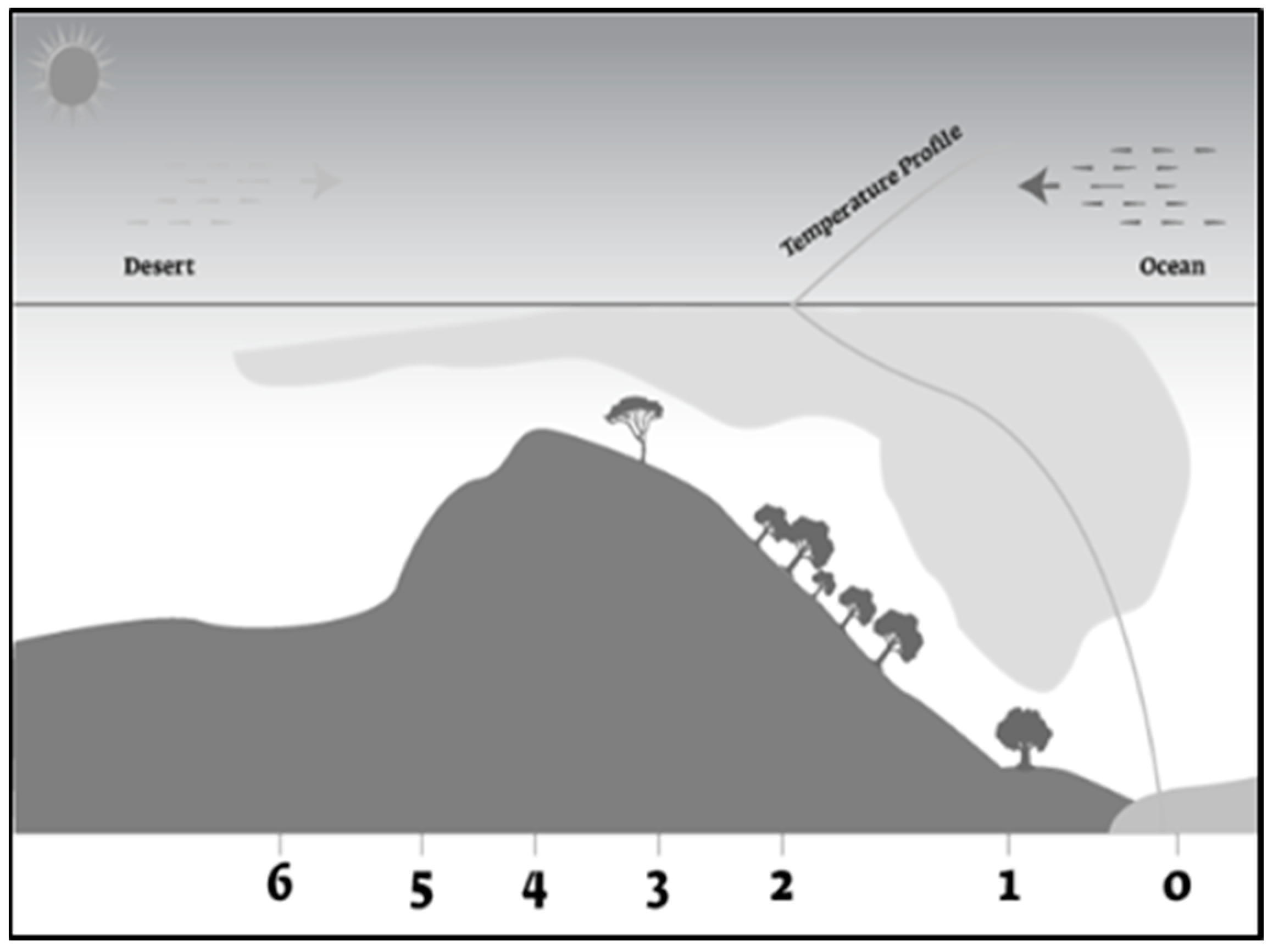
The distribution of rainfall is critical in determining the richness of diverse plant species that are prevalent in the Dhofar Governorate [
26]. The distribution of plants on the high dry plateau is becoming less diverse due to the blowing of hot, dry air from the desert, which hinders the formation of clouds and rain shadow (
Figure 13). The current findings have significant implications for current and future availability of freshwater, with a specific emphasis on inland freshwater ecosystems. The trend of increasing vegetation may benefit the bio environment, socio-economics, and environmental sustainability [
73].
5. Conclusions
This study examined the impacts of climate, ecology, and human activities on vegetation dynamics in Dhofar Governorate, southern Oman, from 2016 to 2021 using satellite data, the ERA5, OLS, and FBCR models. The findings obtained from observation records revealed that the mean annual air temperature trends increased over all stations in air temperatures of 1 °C from 2018 to 2019. Furthermore, the study also examined the interactions between climate variables and the NDVI for the month of October for the period from 2015 to 2021. The results indicated that the trend of warming and humidification, as well as the frequency and intensity of tropical cyclones, was strengthened, thereby creating favourable conditions for the ecological restoration in the region. Moreover, there was an increase in NDVI data changes over the eastern part of Jabal Qara and along the Jabal Samhan mountain ranges, and there was synchronism between rainfall and NDVI over the study area. The current findings have significant implications for current and future freshwater availability, with a specific emphasis on inland freshwater ecosystems. Increased rainfall has a positive impact on the Dhofar Governorate’s agricultural and livestock sectors, which require the use of available water, particularly economically, especially over Jabal Samhan Mountain. Furthermore, the importance of the 12 variables that influenced NDVI levels also varied. The importance of soil type, elevation, slope, rainfall, curvature, humidity, and temperature was highest, while TWI, distance to metropolitan area, aspect, distance to roadways, and geology were lowest. The increasing trend in vegetation may benefit the bio-environment, socioeconomics, and environmental sustainability in the region.


