Review

Global Navigation Satellite Systems as State-of-the-Art Solutions in Precision Agriculture: A Review of Studies Indexed in the Web of Science

Faculty of Agrobiotechnical Sciences Osijek, Josip Juraj Strossmayer University of Osijek, Vladimira Preloga 1, 31000 Osijek, Croatia
*
Author to whom correspondence should be addressed.
Agriculture 2023, 13(7), 1417; https://doi.org/10.3390/agriculture13071417
Submission received: 31 May 2023 / Revised: 15 July 2023 / Accepted: 16 July 2023 / Published: 17 July 2023
(This article belongs to the Section Digital Agriculture)

Abstract

:
Global Navigation Satellite Systems (GNSS) in precision agriculture (PA) represent a cornerstone for field mapping, machinery guidance, and variable rate technology. However, recent improvements in GNSS components (GPS, GLONASS, Galileo, and BeiDou) and novel remote sensing and computer processing-based solutions in PA have not been comprehensively analyzed in scientific reviews. Therefore, this study aims to explore novelties in GNSS components with an interest in PA based on the analysis of scientific papers indexed in the Web of Science Core Collection (WoSCC). The novel solutions in PA using GNSS were determined and ranked based on the citation topic micro criteria in the WoSCC. The most represented citation topics micro based on remote sensing were “NDVI”, “LiDAR”, “Harvesting robot”, and “Unmanned aerial vehicles” while the computer processing-based novelties included “Geostatistics”, “Precise point positioning”, “Simultaneous localization and mapping”, “Internet of things”, and “Deep learning”. Precise point positioning, simultaneous localization and mapping, and geostatistics were the topics that most directly relied on GNSS in 93.6%, 60.0%, and 44.7% of the studies indexed in the WoSCC, respectively. Meanwhile, harvesting robot research has grown rapidly in the past few years and includes several state-of-the-art sensors, which can be expected to improve further in the near future.

1. Introduction

The successful application of Global Navigation Satellite Systems (GNSS) in precision agriculture (PA) has revolutionized farming practices, offering significant benefits in terms of improved efficiency, productivity, and sustainability [1]. GNSS technologies, such as GPS, GLONASS, Galileo, and BeiDou, have been widely adopted in PA applications worldwide [2]. GPS, originating from the United States, has been utilized since its full operational capability was achieved in 1995. Its development traces back to the 1970s as a military project. Similarly, GLONASS, developed by Russia, reached full operational status in 1995 after a development process initiated in the 1970s for military purposes. Galileo, initiated by the European Union, commenced its services in 2016, offering an independent global navigation system with primary civilian purposes. In contrast, BeiDou, developed by China, initially provided regional services in 2000 and achieved global coverage in 2020. These GNSS systems are a cornerstone in various well-documented aspects of PA, including field mapping [3], agricultural machinery guidance and steering [4,5], variable rate technology (VRT) [6], and yield monitoring [7].
GNSS receivers, in conjunction with Geographic Information Systems (GIS), allow for exact field boundary determination and accurate mapping of field features such as roadways, irrigation systems, and drainage networks [8]. This data provides the foundation for further precision agricultural activities such as VRT, yield monitoring, and crop scouting. A thorough understanding of the field’s characteristics and spatial variability allows for the optimization of input utilization, customizing management strategies, and waste minimization, resulting in enhanced resource efficiency and cost savings [9]. The precise guidance and automated steering capabilities of GNSS-based systems contribute to more consistent seed placement, fertilizer application, and other field operations, resulting in improved crop uniformity, optimized input usage, and increased yields [10]. Map-based VRT systems utilize GNSS positioning to deliver site-specific applications of inputs, such as fertilizers, pesticides, and irrigation water [11]. By integrating GNSS data with yield maps, soil maps, and other relevant spatial information, these data are used for the creation of prescription maps that guide VRT equipment to apply inputs at different rates according to the specific needs of different areas within a field [12]. VRT systems further enable optimization of input usage, minimizing environmental impact and maximizing crop productivity by adjusting inputs to the specific requirements of different soil types, nutrient levels, and crop growth stages. Yield monitoring has been significantly improved through the use of GNSS in PA [13]. GNSS receivers integrated with yield monitoring systems precisely measure and map crop yields across the field. By correlating yield data with other spatial information, such as soil maps and management practices, valuable insights for future growing seasons are produced into the factors influencing yield variability within a field [14].
Despite the gains, there are still several research gaps in the use of GNSS in PA that need to be filled. One disadvantage is the reliance on satellite transmissions, which can be hampered by signal blockages and atmospheric conditions [15]. Satellite signals may be obscured or diminished in locations with extensive vegetation, tall structures, or steep terrain, resulting in lower positioning accuracy [16]. Such constraints can have an impact on the dependability and robustness of GNSS-based systems, especially in complicated agricultural settings. As a result, more research and development are required to improve signal reception and processing algorithms in order to offset the impacts of signal blockages and multipath interference [17]. Another GNSS restriction in PA is the requirement for precise and up-to-date georeferenced data for optimal decision-making [18]. While GNSS offers precise location data, the accuracy of other spatial data layers like soil maps, yield maps, and topography data might vary [19]. Therefore, efforts should be made to improve data collection methods, data integration, and data validation processes to ensure the availability of accurate and high-quality spatial data for PA applications. Additionally, there is a need for user-friendly and interoperable PA software and hardware solutions [20]. The complexity of GNSS-based systems and the lack of standardization can present challenges in terms of system integration, data compatibility, and ease of use [21].
While advancements in GNSS technologies have shown great potential in revolutionizing farming practices, there are notable differences in the adoption and acceptance of these solutions globally [6,22]. Among the scientific studies indexed in the Web of Science Core Collection (WoSCC), there is a strong recognition of the benefits of GNSS technologies in PA [23,24,25]. However, present reviews on this topic did not consider the latest state-of-the-art GNSS improvements nor GNSS-based solutions in PA due to their rapid development. Therefore, the aim of this review is to provide an up-to-date analysis of the role of GNSS in PA, its latest development stages relevant to PA, and remote sensing and computer processing-based novel solutions using objective metrics from the WoSCC. The development of low-cost hardware and software solutions in PA has the potential of rapidly increasing its implementation in agricultural practice and thus indirectly leading to even larger advancements in research.

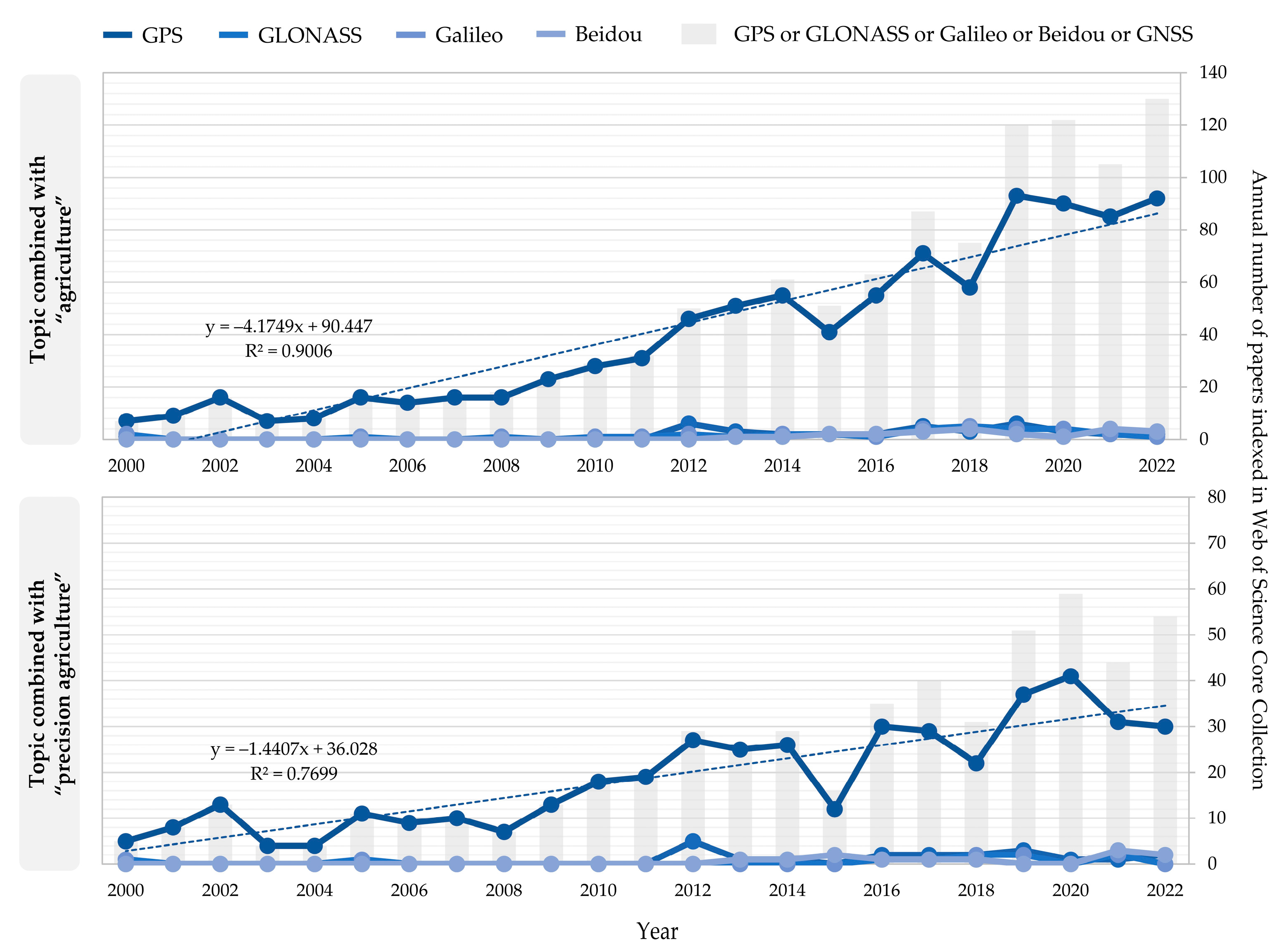
2. Methodology of WoSCC Search for Literature Review

The WoSCC was selected for the literature review in this study due to its present dominance as an academic database, followed by Scopus [26]. The WoSCC consists of ten indexes managed by the Web of Science [27], among which Science Citation Index Expanded (SCIE), Conference Proceedings Citation Index—Science (CPCI-S), and Emerging Sources Citation Index (ESCI) were the most represented in search results The state of GNSS studies in agriculture and PA indexed in the WoSCC was determined according to the advanced search for the topic TS = (agriculture AND (GPS OR GLONASS OR Galileo OR Beidou OR GNSS)) and TS = (precision agriculture AND (GPS OR GLONASS OR Galileo OR Beidou OR GNSS)) for agriculture and PA, respectively. The “exact search” option was disabled for all WoSCC search queries, searching the “topic”, “title”, “abstract”, “keywords”, and “keywords plus” fields in the WoSCC. Therefore, all studies resulting from the search queries were included in the review. The search date was 24 May 2023, which included all studies indexed in the WoSCC up to 2022.
The search and analysis of the citation topic micro was performed as the subset of generalized TS = (precision agriculture AND (GPS OR GLONASS OR Galileo OR Beidou OR GNSS)) search query, including all studies which utilized GNSS in PA indexed in the WoSCC. Since these studies had their citation topics micro-defined and classified by the Web of Science, all results from the search query were retained in the review without additional filtering. The citation topics micro included recently published classifications of scientific studies by the Web of Science, including more than 2500 micro-level citation topics. This classification is hierarchically below the Web of Science subject categories and citation topics meso, enabling a specific and objective assessment of technologies used in the search query.

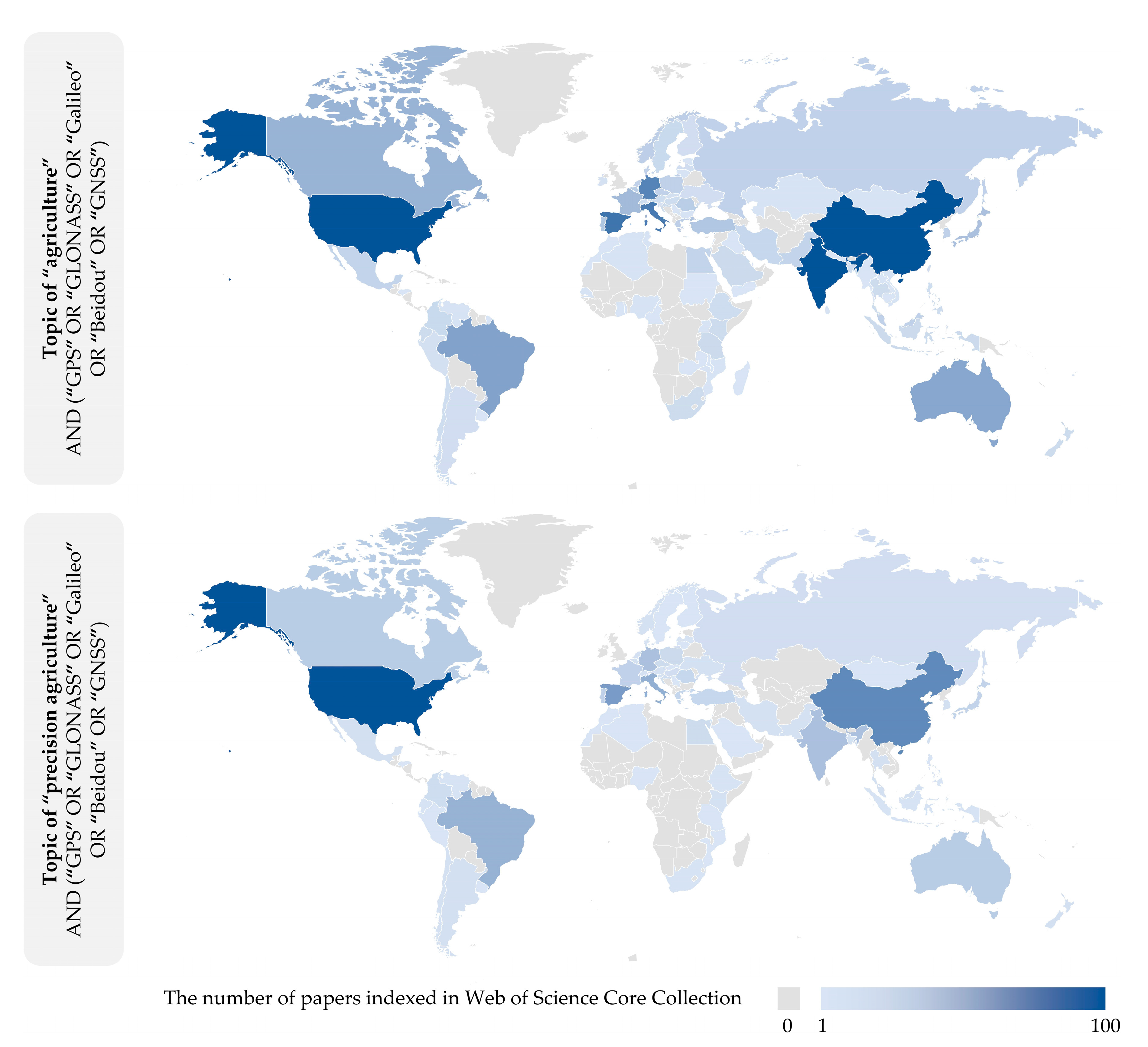
3. State of GNSS in Scientific Studies Indexed in WoSCC Related to PA

According to the number of scientific papers indexed in the WoSCC, GPS is a dominantly used GNSS system for both “agriculture” and “precision agriculture” topics, with the annual number of scientific papers growing rapidly between 2000 and 2022 (Figure 1). However, its overall application in agriculture has a more linear upward trend in comparison to PA, as represented by the coefficient of determination (R2) from linear regression. The presence of broad GNSS topics is increasingly used in scientific studies with GPS, while the studies which focus on other individual GNSS components (GLONASS, Galileo, or BeiDou) remain relatively low.
All four individual GNSS components had major upgrades in recent years, which improved their overall performance in PA (Table 1). The upgrade of constellations with new, modernized satellites (GPS, GLONASS, BeiDou) and the improved operational capabilities due to the addition of new signals (GPS, BeiDou) were the most represented major upgrades.
The United States was the global leader in the total scientific papers indexed in the WoSCC with the topics of GNSS in combination with both “agriculture” and “precision agriculture” (Figure 2, Table 2). China and India were the second and third-ranked countries in terms of scientific production, with China as the leading country for its native BeiDou system. Despite falling behind these three countries in terms of quantitative research numbers, several European countries (France, Germany, England, and Spain) were among the leading countries in PA research based on GNSS. While the majority of the world countries had scientific contributions in this field, the vast majority of African countries had no presence in the analyzed papers. Moreover, they would likely greatly benefit from introducing GNSS in PA in greater quantity [39,40].
In addition to individual system developments, the integration of multiple GNSS systems has gained prominence in PA. Multi-constellation receivers are becoming more prevalent, allowing for simultaneous reception and processing of signals from different GNSS systems [41]. This integration leverages the strengths of each system, improves positioning accuracy, and enhances the availability of satellite signals, especially in environments where signal blockages are common, including dense vegetation and other physical structures [42]. In terms of signal processing, the latest developments in multi-constellation receivers focus on advanced algorithms that optimize the utilization of signals from multiple constellations [43]. By combining signals from multiple constellations, the receivers can mitigate the effects of signal blockages, multipath interference, and ionospheric disturbances [44]. This results in more reliable and precise positioning information, even in challenging environments such as densely vegetated areas or urban landscapes. Another notable development in multi-constellation receivers is the integration of additional sensors to complement the GNSS positioning information. Inertial Measurement Units (IMUs) are commonly integrated into these receivers to provide measurements of acceleration and angular rates [45,46]. The combination of GNSS and IMU data enables the estimation of attitude, velocity, and position with higher accuracy and improved robustness. This integration is particularly beneficial for PA applications that involve dynamic machinery operations, such as autonomous vehicles or robotic systems [47]. The precise positioning and orientation information derived from multi-constellation receivers with integrated IMUs enables precise implement control, accurate path tracking, and obstacle avoidance [48].
The absolute positioning using GNSS provides a moderate level of positioning geometric accuracy, typically within a few meters [49]. However, for the precise operations required in PA, additional correction techniques are employed to enhance the accuracy to the centimeter level. One such method is the Satellite-Based Augmentation System (SBAS), which employs additional geostationary satellites to transmit correction data, thus improving accuracy and integrity. For higher accuracy requirements, Real-Time Kinematic (RTK) positioning is widely adopted [4], frequently as a Continuously Operating Reference Station (CORS) network, consisting of permanent reference stations that monitor satellite signals and provide correction data through internet or wireless communication. These corrections are transmitted to the rover receiver in real time, allowing the rover to correct its position with centimeter-level accuracy. RTK offers real-time feedback and is particularly useful for dynamic agricultural operations where immediate accuracy is crucial, such as autosteering and precise implement control [50]. Network RTK further improved the possibilities of RTK by utilizing a network of reference stations instead of a single base station [51]. These reference stations are commonly distributed over a wide area and collect GNSS observations continuously. Network RTK enables precise positioning over larger areas, eliminates the need for a local base station, and enhances system flexibility and availability. It is particularly beneficial for large-scale PA operations, where a single base station may not provide adequate coverage [52,53]. Another advanced method is Real-Time eXtended (RTX), a satellite-based correction service provided by various commercial providers. RTX corrections are computed by a network of reference stations that collect GNSS observations and send them to a centralized processing center [54]. The center calculates precise correction data and broadcasts it to users via geostationary satellites or internet connections. RTX offers wide-area coverage and eliminates the need for a local base station, making it suitable for operations in remote areas, especially when real-time communication infrastructure is limited or unavailable [55].
Both multi-constellation receivers and GNSS corrections, such as RTK and RTX, were the cornerstone for the development of various remote sensing and computer processing-based novel solutions in all aspects of PA. As represented by the top 15 citation topics micro in the analyzed scientific papers indexed in the WoSCC with the topic of GNSS and PA (Figure 3), several state-of-the-art solutions represent the latest advances in PA. While some of them have been known for decades, including geostatistics and normalized difference vegetation index (NDVI), these are continuously being researched in combination with novel sensors and processing methods.

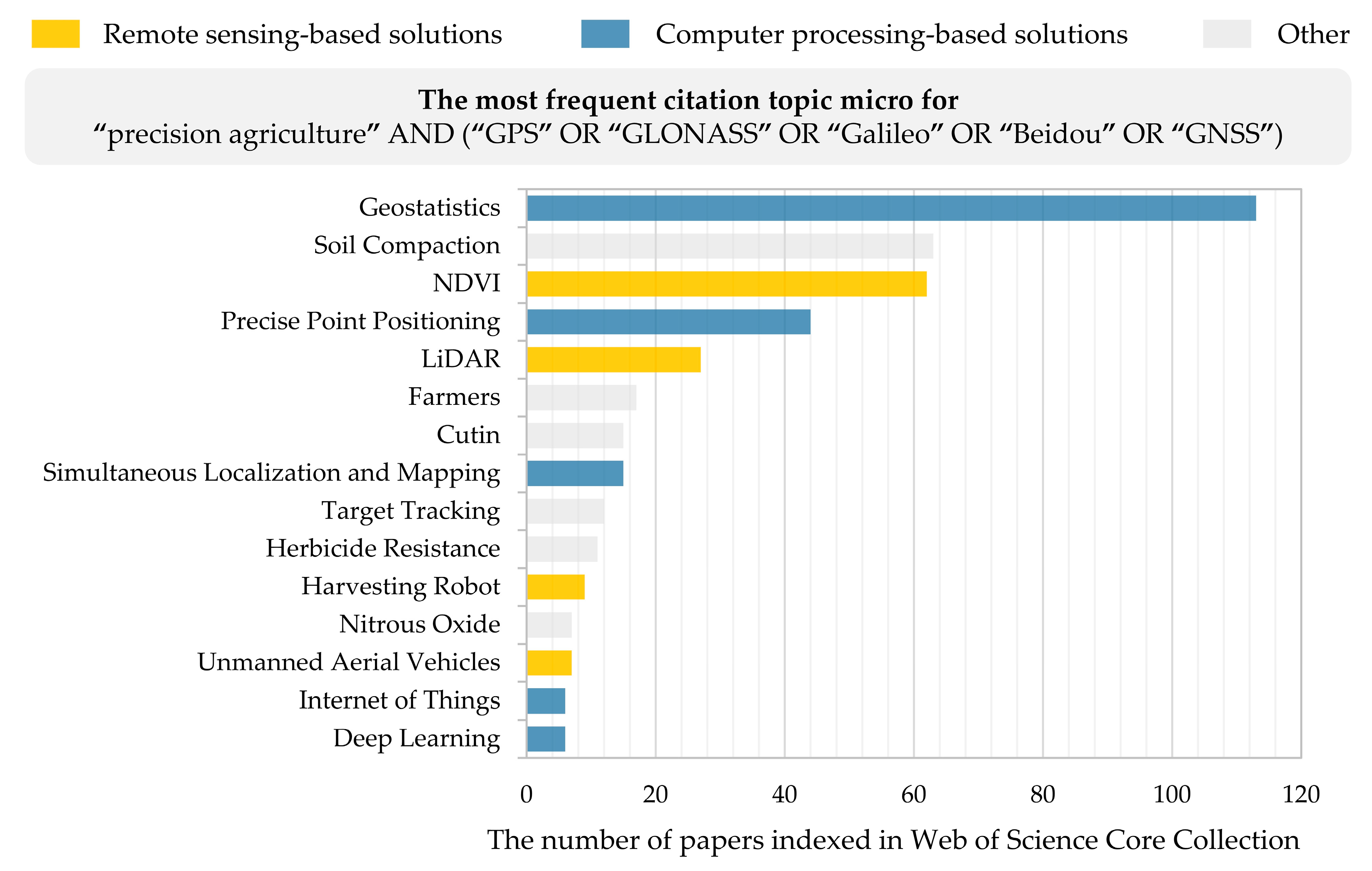
4. GNSS in State-of-the-Art Remote Sensing-Based Solutions in PA

Among the top remote sensing-based solutions from the citation topics micro, NDVI, light detection and ranging (LiDAR), harvesting robot, and unmanned aerial vehicles were the most represented. While NDVI and LiDAR had a slightly growing representation in both agriculture and PA studies, unmanned aerial vehicles and harvesting robots have been rapidly researched since 2010 and 2016, respectively (Figure 4). While GNSS is a crucial component of all these solutions, it was a primary focus of the research in slightly more than 10% of the analyzed studies for NDVI, LiDAR, and harvesting robot (Table 3).

4.1. NDVI

NDVI is the most widely used vegetation index in PA that provides valuable insights into plant health and vegetation vigor [56]. When combined with GNSS technology, NDVI measurements are accurately georeferenced, allowing for spatially explicit analysis and monitoring of crop conditions [57]. While multispectral sensors are traditionally mounted on satellites and unmanned aerial vehicles (UAVs), satellite-based multispectral sensors, such as those onboard satellites like Landsat and Sentinel, provide broader coverage of large agricultural areas [58]. GNSS technology aids in the precise geolocation of satellite images, allowing for accurate mapping of NDVI values across the agricultural landscape [59]. Because satellite imagery is available in near-real-time, it allows for time-series analysis and monitoring of vegetation dynamics throughout the growing season [60]. The handheld or tractor-mounted radiometer is another type of sensor used for NDVI measurements [61,62]. GNSS receivers are commonly supplemented to these portable or tractor-mounted devices, allowing for the exact localization of NDVI readings in specified fields.

4.2. LiDAR

LiDAR is complementary to vegetation indices, such as NDVI, by providing information on the 3D structure of crops and the surrounding environment [63]. The hardware used in PA, LiDAR systems includes a variety of components designed to acquire and analyze precise 3D information, including GNSS for the precise georeferencing of point clouds [64]. Airborne LiDAR sensors, which include lasers, scanning mechanisms, and detectors, are often installed on UAVs [65]. The laser beams image the plant canopy, terrain elevation, and crop structural elements. GNSS technology is critical in these systems because it allows for exact georeferencing of LiDAR data by syncing the sensor’s location and orientation with the acquired measurements [66]. The aircraft or UAVs’ GNSS receivers should provide precise location and timing information, ensuring that the LiDAR data is spatially aligned with the agricultural area. Ground-based LiDAR sensors provide high-resolution data at a smaller scale, allowing for detailed analysis of crop structure and individual plant characteristics [67]. GNSS technology is employed in ground-based LiDAR systems to precisely georeference the acquired data, linking the 3D measurements to their specific spatial locations within the field.

4.3. Harvesting Robot

Unlike NDVI and LiDAR, harvesting robots provide more tangible hardware-based results in PA, significantly improving the process of crop harvesting by automating labor-intensive tasks [68]. The GNSS technology enables these robots to navigate and operate with precise geolocation information, enabling efficient and accurate harvesting operations. RGB cameras, as one of the key sensors used in harvesting robots, capture high-resolution color images of the crops, allowing the robot to visually identify and locate mature or ripe fruits or vegetables [69]. By integrating GNSS for accurate localization and computer vision with RGB cameras for crop detection and identification, these robots can navigate through fields and perform precise harvesting operations. The use of computer vision with RGB cameras in harvesting robots provides several benefits and opens up new opportunities in the field of PA [70]. RGB cameras image the crops, which are subsequently analyzed with computer vision algorithms to extract the color, shape, texture, and other visual characteristics of crops to differentiate between ripe and immature fruits and vegetables [71]. The force/torque sensor allows the robot to detect how much force is needed to harvest the crops without harming them. When paired with GNSS technology, this sensor guarantees that the harvesting robot delivers the necessary force with accuracy, resulting in safe and efficient harvesting operations.

4.4. Unmanned Aerial Vehicles

PA researchers recognized UAVs during the past decade as a cost-effective and efficient means of data collecting and processing [57,72]. When integrated with GNSS technology and advanced positioning techniques such as RTK and Post-Processing Kinematic (PPK), UAVs provide very accurate and exact geolocation capabilities, which improve the efficiency of data collecting and processing in PA. PPK is a post-processing approach in which the UAV captures raw GNSS data during flight and then refines the georeferencing after the data is downloaded and processed offline [73]. PPK processes raw GNSS data from both the UAV-mounted receiver and the ground-based reference station to provide positioning information. This method reduces the requirement for real-time communication between the UAV and the reference station, allowing for more data-collecting flexibility [74]. PPK is especially beneficial in locations with little or no real-time communication infrastructure since data may be gathered and analyzed later when connectivity becomes available. Furthermore, incorporating RTK or PPK capabilities into UAVs improves their autonomous navigation capability [75]. UAVs may follow predetermined flight paths independently with very accurate positional information, boosting data-collecting efficiency and coverage. This is especially useful when scanning large agricultural regions or doing repeated flights to track crop growth and changes over time [76]. The integration of GNSS into UAV aerial spraying systems reduces the risk of spraying outside the designated zone, minimizing environmental impact and optimizing resource utilization [77]. Moreover, GNSS improves the safety of UAV aerial spraying operations through post-spraying analysis and evaluation. The accurate positioning information recorded during the flight can be integrated with other environmental data to assess the efficacy of the spraying operation, identifying areas that require additional treatment or monitoring and optimizing future spraying strategies.

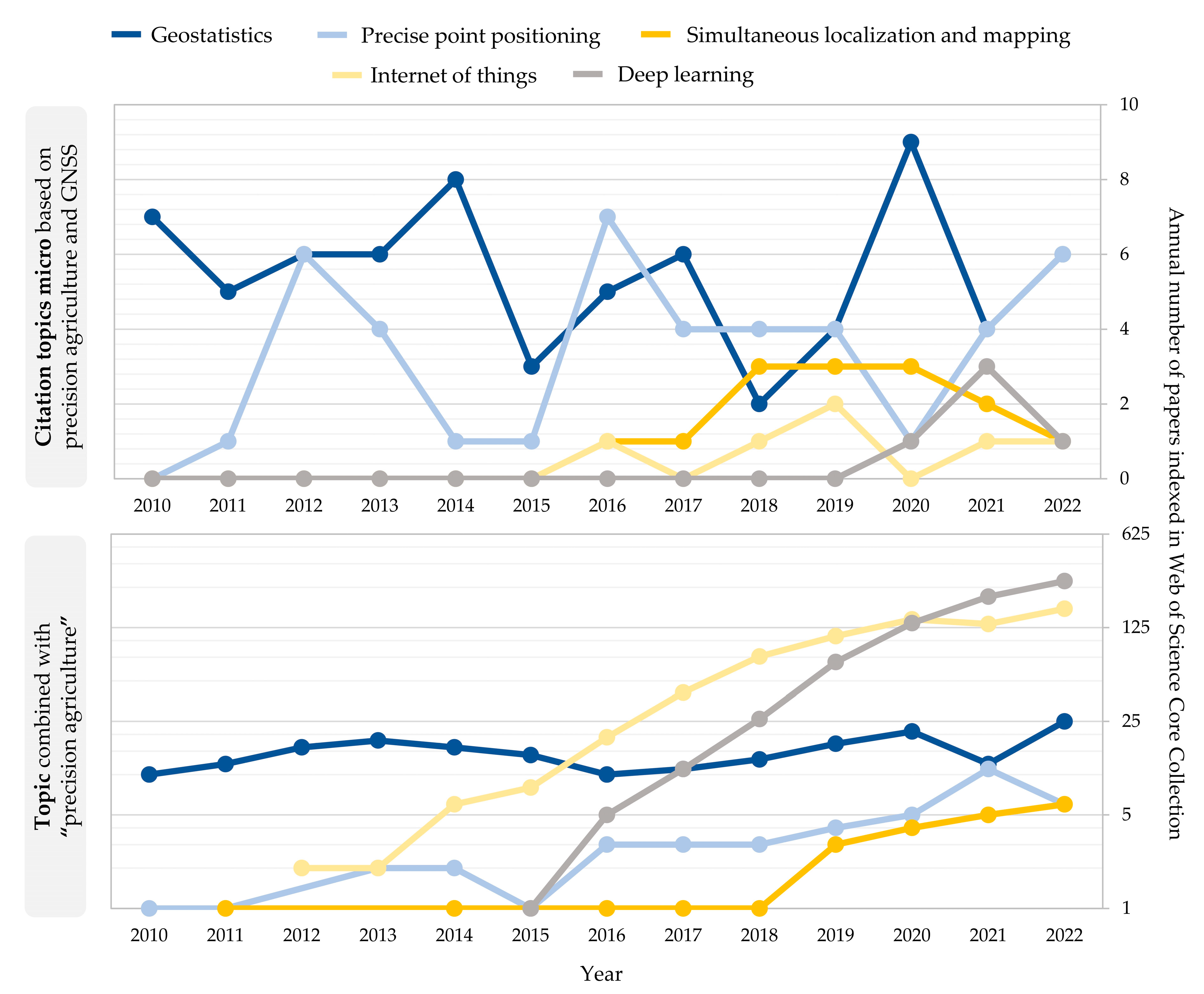
5. GNSS in State-of-the-Art Computer Processing-Based Solutions in PA

Among the computer processing-based citation topics micro that are related to GNSS and PA, geostatistics is a dominant and well-accepted discipline, while the following solutions represent recent novelties (Figure 5). In comparison with the remote sensing-based solutions, those based on computer processing were much more directly related to GNSS, including precise point positioning, simultaneous localization and mapping, and geostatistics (Table 4). The Internet of Things and deep learning has seen a rapid increase in the number of scientific papers indexed in the WoSCC with the GNSS topic, while their primary focus was dominantly put on other developments. Despite that, the strong tailwinds from the Internet of Things and deep learning research will likely improve the use of GNSS in PA according to present trends.

5.1. Geostatistics

The traditional method of soil sampling is collecting a restricted number of samples from a field, as it is an expensive and time-demanding procedure, and evaluating them in a laboratory [78]. To provide an overview of the analyzed soil property in the entire field, geostatistics was proven as an effective method for quantifying soil variability [79]. Kriging is the most well-known geostatistical approach for estimating values at unsampled sites using a collection of observed values at neighboring places [80]. The Kriging approach describes the spatial autocorrelation of the data using a mathematical model called a variogram, which is a measure of how similar the values of the data are as a function of the distance between them [79]. In PA, kriging has been widely utilized to map the spatial variability of soil, vegetation, and topography features [81,82].
Because soil parameters must be precisely georeferenced in order to evaluate spatial autocorrelation, GNSS has become an indispensable instrument in PA for soil analysis [83]. GNSS data may also be used to generate digital elevation models (DEMs), which give information on the field’s topography [84]. DEMs may be used to identify fields prone to waterlogging or erosion and to design drainage systems that reduce exposure to these events [85]. GNSS, combined with geostatistics, may also be used to collect agricultural growth and production variability data. The yield data may be used to generate yield maps that depict crop yield spatial variations across the field using geostatistics, identifying zones with high or low production potential and modifying fertilizer and irrigation rates accordingly [86]. Site-specific management using VRT, for example, is a PA strategy that employs geostatistics and GNSS to adjust management practices to specific sections of the field [87]. This method makes better use of inputs, eliminates the danger of over-application, and lessens the environmental effect of agricultural activities [88].

5.2. Precise Point Positioning

By providing a real-time centimeter-level accuracy based on a single GNSS receiver, Precise Point Positioning (PPP) provides additional flexibility in positioning in PA [41]. PPP employs a network of reference stations to give precise GNSS satellite orbit and clock information, which is utilized to determine the receiver antenna location [89]. PPP can be utilized in places where no reference stations exist, making it especially beneficial in isolated or rural locations. It is also less susceptible to atmospheric and ionospheric disturbances, which can cause inaccurate positioning with RTK and differential GNSS (DGNSS) [90].
Since PA requires high-precision mapping of soil parameters and crop yields in conjunction with geostatistics, PPP supports the detection of spatial heterogeneity in the field. PPP may also be effectively utilized for agricultural machinery guidance by giving precise real-time location information to agricultural machines along specified courses [91]. This enables VRT of inputs like fertilizer and herbicides precisely where they are required, lowering input costs while also limiting environmental effects. These systems have several advantages over manual steering, including enhanced efficiency, less operator fatigue, and improved safety [92]. While manual guiding systems are simple and inexpensive, they are also susceptible to human mistakes, which can lead to unnecessary inter-row overlaps and skips [4]. Assisted guiding systems are more precise than manual guidance systems, but steering corrections must still be made by the operator. Autosteering systems, on the other hand, take full control of the machinery and direct it along a predefined course automatically [93]. These systems use PPP or other GNSS correlations with a variety of sensors to deliver positioning information and automatically perform steering corrections. In addition to the GNSS receiver, IMUs and cameras are also employed to offer additional information about the vehicle’s surroundings and to assist the autosteering system in making precise steering adjustments [94].

5.3. Simultaneous Localization and Mapping

Simultaneous Localization and Mapping (SLAM) is a PA technology that includes building a map of an area while also determining the position of a robot or vehicle within the environment [95]. The positioning information from GNSS signals is used to identify the robot’s location inside the surroundings in relation to a set of specified landmarks [96]. Other sensors, including LiDAR, cameras, and IMUs, can also be used by SLAM to produce a comprehensive map of the surroundings. The production of precise maps of fields and orchards is an important use of GNSS-based SLAM in PA [97]. GNSS-based SLAM may also be utilized for precise agricultural machinery guiding [98]. As irrigation is another important part of agriculture, precision irrigation may assist in minimizing water use while boosting crop yields. By producing precise maps of the field topography, it is possible to recognize places within the field that require irrigation and apply water just where it is required [99].

5.4. Internet of Things

The Internet of Things (IoT) has emerged as a critical tool in PA, allowing farmers to collect real-time data from sensors and devices strategically placed across their fields and farms [100]. GNSS technology is vital in IoT-based PA, delivering precise location and timing data that is required by many IoT applications [101]. The collection of environmental data such as temperature, humidity, and soil moisture is one of the key uses of IoT in PA [102]. For these sensors, GNSS technology offers accurate position information, guaranteeing that the data is connected to the proper location inside the field or farm. Monitoring livestock health and well-being is another application of IoT in PA [103]. IoT sensors may be fitted to cattle to monitor vital indications like heart rate, respiration rate, and body temperature, providing early warning of health concerns that could jeopardize the animals’ well-being [104]. GNSS technology may be used to track the movement of animals inside the farm, allowing farmers to monitor grazing patterns and detect underused farm regions.

5.5. Deep Learning

Deep learning has emerged as a strong tool for precision agricultural data analysis. GNSS technology offers precise geolocation data for satellite images, enabling deep learning algorithms to monitor crop growth and development across time [105]. Deep learning algorithms may identify parts of a field that may require more irrigation, fertilizer, or pest control methods by evaluating patterns in satellite imaging data [106]. Patterns and trends that may suggest inadequate growing conditions may be recognized by evaluating data acquired with IoT sensors using deep learning algorithms [107]. This data may be used to change irrigation and fertilization schedules, ensuring that crops receive the appropriate amount of water and nutrients at the appropriate time. GNSS technology may be used to geolocate these sensors, giving the sensor data geographical context and allowing for more precise analysis [108]. Convolutional Neural Networks (CNNs) are commonly utilized in PA for image processing, enabling recognition of specific crop traits or growth phases by utilizing GNSS technology to offer precise geolocation information [109]. Overall, deep learning has the potential to improve various present technologies as flexible tools in PA, including UAV imaging [110], satellite imagery analysis [111], and livestock monitoring [112].

6. Conclusions

In conclusion, recent major upgrades in all four individual GNSS components have significantly improved their overall performance in PA. The upgrade of constellations with new, modernized satellites, such as GPS, GLONASS, and BeiDou, along with the addition of new signals, particularly in GPS and BeiDou, have been the most prominent advancements. The United States has emerged as the global leader in scientific research on GNSS in combination with precision agriculture (29.3% of global studies), followed by China with 11.6% of global studies. European countries, including France, Germany, England, and Spain, have also made significant contributions to PA research based on GNSS, especially in the research based on individual GNSS components. However, the majority of African countries have had limited presence in the analyzed papers, despite their potential to greatly benefit from the introduction of GNSS in PA.
The integration of multiple GNSS systems has gained prominence in PA, with multi-constellation receivers becoming more prevalent. This integration leverages the strengths of each system, improves positioning accuracy, and enhances satellite signal availability, especially in challenging environments with signal blockages. Advanced algorithms in multi-constellation receivers optimize the utilization of signals from multiple constellations, mitigating the effects of signal blockages, interference, and disturbances. Additionally, the integration of additional sensors, such as IMUs, further enhances positioning accuracy and robustness, particularly for dynamic machinery operations in PA applications. The analyzed studies indicate that PA has the potential to advance even further with the help of GNSS technology thanks to the integration of remote sensing and computer processing-based solutions like NDVI, LiDAR, harvesting robots, unmanned aerial vehicles, geostatistics, PPP, SLAM, IoT, and deep learning. PPP, SLAM, and geostatistics were particularly dependent on GNSS research, with 93.6%, 60.0%, and 44.7% of studies indexed in WoSCC matched with the GNSS in topic search, respectively.
Nevertheless, there are still a number of research gaps that need to be filled in order to fully utilize GNSS in PA. The main drawbacks of signal blockages, multipath interference, and atmospheric circumstances have been addressed in recent studies on the subject. These factors can impair the resilience and dependability of GNSS-based systems, as well as the most advanced GNSS-based solutions for PA. To overcome present challenges and maximize the potential of GNSS in transforming agricultural practices toward greater productivity, sustainability, and efficiency, ongoing research and development efforts in GNSS are still required. To ensure the availability of precise and high-quality spatial data for precision agricultural applications, efforts should also be made to improve data-gathering techniques, integration, and validation procedures. In order to solve issues with system integration, data interoperability, and simplicity of use, it is also necessary to develop user-friendly and interoperable precision agricultural software and hardware solutions.

Author Contributions

Conceptualization, D.R.; methodology, D.R.; software, D.R.; validation, I.P., and M.J.; formal analysis, D.R., I.P. and M.J.; investigation, D.R.; resources, D.R.; data curation, D.R.; writing—original draft preparation, D.R.; writing—review and editing, D.R., I.P. and M.J.; visualization, D.R.; supervision, I.P. and M.J.; project administration, M.J.; funding acquisition, D.R., I.P. and M.J. All authors have read and agreed to the published version of the manuscript.

Funding

This research received no external funding.

Institutional Review Board Statement

Not applicable.

Data Availability Statement

Publicly available datasets were analyzed in this study. This data can be found here: https://www.webofscience.com/wos/woscc/advanced-search (accessed on 25 May 2023).

Conflicts of Interest

The authors declare no conflict of interest.

References

  1. Shannon, D.; Clay, D.E.; Sudduth, K.A. An Introduction to Precision Agriculture. In Precision Agriculture Basics; John Wiley & Sons, Ltd.: Hoboken, NJ, USA, 2018; pp. 1–12. ISBN 978-0-89118-367-9. [Google Scholar]
  2. Kumar, P.; Srivastava, P.K.; Tiwari, P.; Mall, R.K. Chapter 20—Application of GPS and GNSS Technology in Geosciences. In GPS and GNSS Technology in Geosciences; Petropoulos, G.P., Srivastava, P.K., Eds.; Elsevier: Amsterdam, The Netherlands, 2021; pp. 415–427. ISBN 978-0-12-818617-6. [Google Scholar]
  3. Catania, P.; Comparetti, A.; Febo, P.; Morello, G.; Orlando, S.; Roma, E.; Vallone, M. Positioning Accuracy Comparison of GNSS Receivers Used for Mapping and Guidance of Agricultural Machines. Agronomy 2020, 10, 924. [Google Scholar] [CrossRef]
  4. Radočaj, D.; Plaščak, I.; Heffer, G.; Jurišić, M. A Low-Cost Global Navigation Satellite System Positioning Accuracy Assessment Method for Agricultural Machinery. Appl. Sci. 2022, 12, 693. [Google Scholar] [CrossRef]
  5. Radicioni, F.; Stoppini, A.; Brigante, R.; Brozzi, A.; Tosi, G. GNSS Network RTK for Automatic Guidance in Agriculture: Testing and Performance Evaluation. In Computational Science and Its Applications—ICCSA 2020, Proceedings of the 20th International Conference, Cagliari, Italy, 1–4 July 2020; Gervasi, O., Murgante, B., Misra, S., Garau, C., Blečić, I., Taniar, D., Apduhan, B.O., Rocha, A.M.A.C., Tarantino, E., Torre, C.M., et al., Eds.; Springer International Publishing: Cham, Switzerland, 2020; pp. 19–35. [Google Scholar]
  6. Perez-Ruiz, M.; Martínez-Guanter, J.; Upadhyaya, S.K. Chapter 15—High-Precision GNSS for Agricultural Operations. In GPS and GNSS Technology in Geosciences; Petropoulos, G.P., Srivastava, P.K., Eds.; Elsevier: Amsterdam, The Netherlands, 2021; pp. 299–335. ISBN 978-0-12-818617-6. [Google Scholar]
  7. Liu, R.; Sun, Y.; Li, M.; Zhang, M.; Zhang, Z.; Li, H.; Yang, W. Development and Application Experiments of a Grain Yield Monitoring System. Comput. Electron. Agric. 2022, 195, 106851. [Google Scholar] [CrossRef]
  8. Neupane, J.; Guo, W. Agronomic Basis and Strategies for Precision Water Management: A Review. Agronomy 2019, 9, 87. [Google Scholar] [CrossRef] [Green Version]
  9. Saiz-Rubio, V.; Rovira-Más, F. From Smart Farming towards Agriculture 5.0: A Review on Crop Data Management. Agronomy 2020, 10, 207. [Google Scholar] [CrossRef] [Green Version]
  10. Fu, J.; Ji, C.; Liu, H.; Wang, W.; Zhang, G.; Gao, Y.; Zhou, Y.; Abdeen, M.A. Research Progress and Prospect of Mechanized Harvesting Technology in the First Season of Ratoon Rice. Agriculture 2022, 12, 620. [Google Scholar] [CrossRef]
  11. Rokhafrouz, M.; Latifi, H.; Abkar, A.A.; Wojciechowski, T.; Czechlowski, M.; Naieni, A.S.; Maghsoudi, Y.; Niedbała, G. Simplified and Hybrid Remote Sensing-Based Delineation of Management Zones for Nitrogen Variable Rate Application in Wheat. Agriculture 2021, 11, 1104. [Google Scholar] [CrossRef]
  12. Ammoniaci, M.; Kartsiotis, S.-P.; Perria, R.; Storchi, P. State of the Art of Monitoring Technologies and Data Processing for Precision Viticulture. Agriculture 2021, 11, 201. [Google Scholar] [CrossRef]
  13. Yang, L.; Wang, X.; Li, Y.; Xie, Z.; Xu, Y.; Han, R.; Wu, C. Identifying Working Trajectories of the Wheat Harvester In-Field Based on K-Means Algorithm. Agriculture 2022, 12, 1837. [Google Scholar] [CrossRef]
  14. dela Torre, D.M.G.; Gao, J.; Macinnis-Ng, C. Remote Sensing-Based Estimation of Rice Yields Using Various Models: A Critical Review. Geo-Spat. Inf. Sci. 2021, 24, 580–603. [Google Scholar] [CrossRef]
  15. Vargas, J.; Alsweiss, S.; Toker, O.; Razdan, R.; Santos, J. An Overview of Autonomous Vehicles Sensors and Their Vulnerability to Weather Conditions. Sensors 2021, 21, 5397. [Google Scholar] [CrossRef]
  16. Gao, Y.; Li, G. A New GNSS Spoofing Signal Power Control Algorithm for Receiver Sensors in Acquisition Phase and Subsequent Control. Sensors 2022, 22, 6588. [Google Scholar] [CrossRef]
  17. Xue, Z.; Lu, Z.; Xiao, Z.; Song, J.; Ni, S. Overview of Multipath Mitigation Technology in Global Navigation Satellite System. Front. Phys. 2022, 10, 1071539. [Google Scholar] [CrossRef]
  18. Tantalaki, N.; Souravlas, S.; Roumeliotis, M. Data-Driven Decision Making in Precision Agriculture: The Rise of Big Data in Agricultural Systems. J. Agric. Food Inf. 2019, 20, 344–380. [Google Scholar] [CrossRef]
  19. Behrens, T.; Schmidt, K.; MacMillan, R.A.; Viscarra Rossel, R.A. Multi-Scale Digital Soil Mapping with Deep Learning. Sci. Rep. 2018, 8, 15244. [Google Scholar] [CrossRef] [Green Version]
  20. Jeppesen, J.H.; Ebeid, E.; Jacobsen, R.H.; Toftegaard, T.S. Open Geospatial Infrastructure for Data Management and Analytics in Interdisciplinary Research. Comput. Electron. Agric. 2018, 145, 130–141. [Google Scholar] [CrossRef]
  21. Moselhi, O.; Bardareh, H.; Zhu, Z. Automated Data Acquisition in Construction with Remote Sensing Technologies. Appl. Sci. 2020, 10, 2846. [Google Scholar] [CrossRef] [Green Version]
  22. Ammann, J.; Umstätter, C.; El Benni, N. The Adoption of Precision Agriculture Enabling Technologies in Swiss Outdoor Vegetable Production: A Delphi Study. Precis. Agric. 2022, 23, 1354–1374. [Google Scholar] [CrossRef]
  23. Botta, A.; Cavallone, P.; Baglieri, L.; Colucci, G.; Tagliavini, L.; Quaglia, G. A Review of Robots, Perception, and Tasks in Precision Agriculture. Appl. Mech. 2022, 3, 830–854. [Google Scholar] [CrossRef]
  24. Singh, A.P.; Yerudkar, A.; Mariani, V.; Iannelli, L.; Glielmo, L. A Bibliometric Review of the Use of Unmanned Aerial Vehicles in Precision Agriculture and Precision Viticulture for Sensing Applications. Remote Sens. 2022, 14, 1604. [Google Scholar] [CrossRef]
  25. Loures, L.; Chamizo, A.; Ferreira, P.; Loures, A.; Castanho, R.; Panagopoulos, T. Assessing the Effectiveness of Precision Agriculture Management Systems in Mediterranean Small Farms. Sustainability 2020, 12, 3765. [Google Scholar] [CrossRef]
  26. Zhu, J.; Liu, W. A Tale of Two Databases: The Use of Web of Science and Scopus in Academic Papers. Scientometrics 2020, 123, 321–335. [Google Scholar] [CrossRef] [Green Version]
  27. Web of Science Core Collection. Available online: https://webofscience.help.clarivate.com/Content/wos-core-collection/wos-core-collection.htm (accessed on 10 July 2023).
  28. Thoelert, S.; Steigenberger, P.; Montenbruck, O.; Meurer, M. Signal Analysis of the First GPS III Satellite. GPS Solut. 2019, 23, 92. [Google Scholar] [CrossRef]
  29. Hein, G.W. Status, Perspectives and Trends of Satellite Navigation. Satell. Navig. 2020, 1, 22. [Google Scholar] [CrossRef]
  30. Wang, M.; Lu, X.; Rao, Y. GNSS Signal Distortion Estimation: A Comparative Analysis of L5 Signal from GPS II and GPS III. Appl. Sci. 2022, 12, 3791. [Google Scholar] [CrossRef]
  31. Duan, B.; Hugentobler, U.; Hofacker, M.; Selmke, I. Improving Solar Radiation Pressure Modeling for GLONASS Satellites. J. Geod. 2020, 94, 72. [Google Scholar] [CrossRef]
  32. Wu, J.; Li, X.; Yuan, Y.; Li, X.; Zheng, H.; Zhang, W. Estimation of GLONASS Inter-Frequency Clock Bias Considering the Phase Center Offset Differences on the L3 Signal. GPS Solut. 2023, 27, 130. [Google Scholar] [CrossRef]
  33. Ogutcu, S. Assessing the Contribution of Galileo to GPS+GLONASS PPP: Towards Full Operational Capability. Measurement 2020, 151, 107143. [Google Scholar] [CrossRef]
  34. Fernandez-Hernandez, I.; Chamorro-Moreno, A.; Cancela-Diaz, S.; Calle-Calle, J.D.; Zoccarato, P.; Blonski, D.; Senni, T.; de Blas, F.J.; Hernández, C.; Simón, J.; et al. Galileo High Accuracy Service: Initial Definition and Performance. GPS Solut. 2022, 26, 65. [Google Scholar] [CrossRef]
  35. Wang, N.; Li, Z.; Montenbruck, O.; Tang, C. Quality Assessment of GPS, Galileo and BeiDou-2/3 Satellite Broadcast Group Delays. Adv. Space Res. 2019, 64, 1764–1779. [Google Scholar] [CrossRef]
  36. Wang, M.; Wang, J.; Dong, D.; Meng, L.; Chen, J.; Wang, A.; Cui, H. Performance of BDS-3: Satellite Visibility and Dilution of Precision. GPS Solut. 2019, 23, 56. [Google Scholar] [CrossRef]
  37. Yang, Y.; Gao, W.; Guo, S.; Mao, Y.; Yang, Y. Introduction to BeiDou-3 Navigation Satellite System. Navigation 2019, 66, 7–18. [Google Scholar] [CrossRef] [Green Version]
  38. Liu, T.; Chen, H.; Song, C.; Wang, Y.; Yuan, P.; Geng, T.; Jiang, W. Beidou-3 Precise Point Positioning Ambiguity Resolution with B1I/B3I/B1C/B2a/B2b Phase Observable-Specific Signal Bias and Satellite B1I/B3I Legacy Clock. Adv. Space Res. 2023, 72, 488–502. [Google Scholar] [CrossRef]
  39. Onyango, C.M.; Nyaga, J.M.; Wetterlind, J.; Söderström, M.; Piikki, K. Precision Agriculture for Resource Use Efficiency in Smallholder Farming Systems in Sub-Saharan Africa: A Systematic Review. Sustainability 2021, 13, 1158. [Google Scholar] [CrossRef]
  40. Lowenberg-DeBoer, J.; Erickson, B. Setting the Record Straight on Precision Agriculture Adoption. Agron. J. 2019, 111, 1552–1569. [Google Scholar] [CrossRef] [Green Version]
  41. Guo, J.; Li, X.; Li, Z.; Hu, L.; Yang, G.; Zhao, C.; Fairbairn, D.; Watson, D.; Ge, M. Multi-GNSS Precise Point Positioning for Precision Agriculture. Precis. Agric. 2018, 19, 895–911. [Google Scholar] [CrossRef] [Green Version]
  42. Jin, S.; Wang, Q.; Dardanelli, G. A Review on Multi-GNSS for Earth Observation and Emerging Applications. Remote Sens. 2022, 14, 3930. [Google Scholar] [CrossRef]
  43. Tomaštík, J.; Everett, T. Static Positioning under Tree Canopy Using Low-Cost GNSS Receivers and Adapted RTKLIB Software. Sensors 2023, 23, 3136. [Google Scholar] [CrossRef]
  44. Magalhães, A.; Bastos, L.; Maia, D.; Gonçalves, J.A. Relative Positioning in Remote Areas Using a GNSS Dual Frequency Smartphone. Sensors 2021, 21, 8354. [Google Scholar] [CrossRef]
  45. Li, S.; Zhang, M.; Ji, Y.; Zhang, Z.; Cao, R.; Chen, B.; Li, H.; Yin, Y. Agricultural Machinery GNSS/IMU-Integrated Navigation Based on Fuzzy Adaptive Finite Impulse Response Kalman Filtering Algorithm. Comput. Electron. Agric. 2021, 191, 106524. [Google Scholar] [CrossRef]
  46. Yuan, W.; Choi, D.; Bolkas, D. GNSS-IMU-Assisted Colored ICP for UAV-LiDAR Point Cloud Registration of Peach Trees. Comput. Electron. Agric. 2022, 197, 106966. [Google Scholar] [CrossRef]
  47. Yan, Y.; Zhang, B.; Zhou, J.; Zhang, Y.; Liu, X. Real-Time Localization and Mapping Utilizing Multi-Sensor Fusion and Visual–IMU–Wheel Odometry for Agricultural Robots in Unstructured, Dynamic and GPS-Denied Greenhouse Environments. Agronomy 2022, 12, 1740. [Google Scholar] [CrossRef]
  48. Causa, F.; Asciolla, M.; Opromolla, R.; Molina, P.; Mennella, A.; Nisi, M.; Fasano, G. UAV-Based LiDAR Mapping with Galileo-GPS PPP Processing and Cooperative Navigation. In Proceedings of the 2022 International Conference on Unmanned Aircraft Systems (ICUAS), Dubrovnik, Croatia, 21–24 June 2022; pp. 938–947. [Google Scholar]
  49. Wang, L.; Li, Z.; Wang, N.; Wang, Z. Real-Time GNSS Precise Point Positioning for Low-Cost Smart Devices. GPS Solut. 2021, 25, 69. [Google Scholar] [CrossRef]
  50. Liu, K.; Cheng, G.; Kong, Z. Beidou Agricultural Machinery Automatic Driving Software Design. In Proceedings of the 2019 IEEE 4th Advanced Information Technology, Electronic and Automation Control Conference (IAEAC), Chengdu, China, 20–22 December 2019; Volume 1, pp. 1770–1775. [Google Scholar]
  51. Šugar, D.; Kliman, A.; Bačić, Ž.; Nevistić, Z. Assessment of GNSS Galileo Contribution to the Modernization of CROPOS’s Services. Sensors 2023, 23, 2466. [Google Scholar] [CrossRef]
  52. Roma, E.; Laudicina, V.A.; Vallone, M.; Catania, P. Application of Precision Agriculture for the Sustainable Management of Fertilization in Olive Groves. Agronomy 2023, 13, 324. [Google Scholar] [CrossRef]
  53. Vinci, A.; Brigante, R.; Traini, C.; Farinelli, D. Geometrical Characterization of Hazelnut Trees in an Intensive Orchard by an Unmanned Aerial Vehicle (UAV) for Precision Agriculture Applications. Remote Sens. 2023, 15, 541. [Google Scholar] [CrossRef]
  54. Ozer Yigit, C.; Bezcioglu, M.; Ilci, V.; Murat Ozulu, I.; Metin Alkan, R.; Anil Dindar, A.; Karadeniz, B. Assessment of Real-Time PPP with Trimble RTX Correction Service for Real-Time Dynamic Displacement Monitoring Based on High-Rate GNSS Observations. Measurement 2022, 201, 111704. [Google Scholar] [CrossRef]
  55. Kharel, T.P.; Ashworth, A.J.; Owens, P.R. Evaluating How Operator Experience Level Affects Efficiency Gains for Precision Agricultural Tools. Agric. Environ. Lett. 2022, 7, e20085. [Google Scholar] [CrossRef]
  56. Radočaj, D.; Šiljeg, A.; Marinović, R.; Jurišić, M. State of Major Vegetation Indices in Precision Agriculture Studies Indexed in Web of Science: A Review. Agriculture 2023, 13, 707. [Google Scholar] [CrossRef]
  57. Lu, W.; Okayama, T.; Komatsuzaki, M. Rice Height Monitoring between Different Estimation Models Using UAV Photogrammetry and Multispectral Technology. Remote Sens. 2022, 14, 78. [Google Scholar] [CrossRef]
  58. Segarra, J.; Buchaillot, M.L.; Araus, J.L.; Kefauver, S.C. Remote Sensing for Precision Agriculture: Sentinel-2 Improved Features and Applications. Agronomy 2020, 10, 641. [Google Scholar] [CrossRef]
  59. Ahmad, L.; Mahdi, S.S. Tool and Technologies in Precision Agriculture. In Satellite Farming: An Information and Technology Based Agriculture; Ahmad, L., Mahdi, S.S., Eds.; Springer International Publishing: Cham, Switzerland, 2018; pp. 31–45. ISBN 978-3-030-03448-1. [Google Scholar]
  60. Radocaj, D.; Jurisic, M.; Gasparovic, M.; Plascak, I. Optimal Soybean (Glycine max L.) Land Suitability Using GIS-Based Multicriteria Analysis and Sentinel-2 Multitemporal Images. Remote Sens. 2020, 12, 1463. [Google Scholar] [CrossRef]
  61. Pallottino, F.; Antonucci, F.; Costa, C.; Bisaglia, C.; Figorilli, S.; Menesatti, P. Optoelectronic Proximal Sensing Vehicle-Mounted Technologies in Precision Agriculture: A Review. Comput. Electron. Agric. 2019, 162, 859–873. [Google Scholar] [CrossRef]
  62. Zhang, J.; Wang, C.; Yang, C.; Jiang, Z.; Zhou, G.; Wang, B.; Shi, Y.; Zhang, D.; You, L.; Xie, J. Evaluation of a UAV-Mounted Consumer Grade Camera with Different Spectral Modifications and Two Handheld Spectral Sensors for Rapeseed Growth Monitoring: Performance and Influencing Factors. Precis. Agric. 2020, 21, 1092–1120. [Google Scholar] [CrossRef]
  63. Banerjee, B.P.; Spangenberg, G.; Kant, S. Fusion of Spectral and Structural Information from Aerial Images for Improved Biomass Estimation. Remote Sens. 2020, 12, 3164. [Google Scholar] [CrossRef]
  64. Ravi, R.; Shamseldin, T.; Elbahnasawy, M.; Lin, Y.-J.; Habib, A. Bias Impact Analysis and Calibration of UAV-Based Mobile LiDAR System with Spinning Multi-Beam Laser Scanner. Appl. Sci. 2018, 8, 297. [Google Scholar] [CrossRef] [Green Version]
  65. Mandlburger, G.; Pfennigbauer, M.; Schwarz, R.; Flöry, S.; Nussbaumer, L. Concept and Performance Evaluation of a Novel UAV-Borne Topo-Bathymetric LiDAR Sensor. Remote Sens. 2020, 12, 986. [Google Scholar] [CrossRef] [Green Version]
  66. Hariz, F.; Bouslimani, Y.; Ghribi, M. High-Resolution Mobile Mapping Platform Using 15-mm Accuracy LiDAR and SPAN/TerraStar C-PRO Technologies. IEEE J. Miniaturization Air Space Syst. 2023, 4, 122–135. [Google Scholar] [CrossRef]
  67. Esser, F.; Klingbeil, L.; Zabawa, L.; Kuhlmann, H. Quality Analysis of a High-Precision Kinematic Laser Scanning System for the Use of Spatio-Temporal Plant and Organ-Level Phenotyping in the Field. Remote Sens. 2023, 15, 1117. [Google Scholar] [CrossRef]
  68. Kootstra, G.; Wang, X.; Blok, P.M.; Hemming, J.; van Henten, E. Selective Harvesting Robotics: Current Research, Trends, and Future Directions. Curr. Robot. Rep. 2021, 2, 95–104. [Google Scholar] [CrossRef]
  69. Karkee, M.; Zhang, Q.; Silwal, A. Agricultural Robots for Precision Agricultural Tasks in Tree Fruit Orchards. In Innovation in Agricultural Robotics for Precision Agriculture: A Roadmap for Integrating Robots in Precision Agriculture; Bechar, A., Ed.; Progress in Precision Agriculture; Springer International Publishing: Cham, Switzerland, 2021; pp. 63–89. ISBN 978-3-030-77036-5. [Google Scholar]
  70. Mavridou, E.; Vrochidou, E.; Papakostas, G.A.; Pachidis, T.; Kaburlasos, V.G. Machine Vision Systems in Precision Agriculture for Crop Farming. J. Imaging 2019, 5, 89. [Google Scholar] [CrossRef] [PubMed] [Green Version]
  71. Sun, M.; Xu, L.; Chen, X.; Ji, Z.; Zheng, Y.; Jia, W. BFP Net: Balanced Feature Pyramid Network for Small Apple Detection in Complex Orchard Environment. Plant Phenomics 2022, 2022, 9892464. [Google Scholar] [CrossRef] [PubMed]
  72. Gašparović, M.; Zrinjski, M.; Barković, Đ.; Radočaj, D. An Automatic Method for Weed Mapping in Oat Fields Based on UAV Imagery. Comput. Electron. Agric. 2020, 173, 105385. [Google Scholar] [CrossRef]
  73. Xu, R.; Li, C.; Bernardes, S. Development and Testing of a UAV-Based Multi-Sensor System for Plant Phenotyping and Precision Agriculture. Remote Sens. 2021, 13, 3517. [Google Scholar] [CrossRef]
  74. Famiglietti, N.A.; Cecere, G.; Grasso, C.; Memmolo, A.; Vicari, A. A Test on the Potential of a Low Cost Unmanned Aerial Vehicle RTK/PPK Solution for Precision Positioning. Sensors 2021, 21, 3882. [Google Scholar] [CrossRef]
  75. Merz, M.; Pedro, D.; Skliros, V.; Bergenhem, C.; Himanka, M.; Houge, T.; Matos-Carvalho, J.P.; Lundkvist, H.; Cürüklü, B.; Hamrén, R.; et al. Autonomous UAS-Based Agriculture Applications: General Overview and Relevant European Case Studies. Drones 2022, 6, 128. [Google Scholar] [CrossRef]
  76. Aslan, M.F.; Durdu, A.; Sabanci, K.; Ropelewska, E.; Gültekin, S.S. A Comprehensive Survey of the Recent Studies with UAV for Precision Agriculture in Open Fields and Greenhouses. Appl. Sci. 2022, 12, 1047. [Google Scholar] [CrossRef]
  77. Biglia, A.; Grella, M.; Bloise, N.; Comba, L.; Mozzanini, E.; Sopegno, A.; Pittarello, M.; Dicembrini, E.; Alcatrão, L.E.; Guglieri, G.; et al. UAV-Spray Application in Vineyards: Flight Modes and Spray System Adjustment Effects on Canopy Deposit, Coverage, and off-Target Losses. Sci. Total Environ. 2022, 845, 157292. [Google Scholar] [CrossRef]
  78. Costa, L.; Kunwar, S.; Ampatzidis, Y.; Albrecht, U. Determining Leaf Nutrient Concentrations in Citrus Trees Using UAV Imagery and Machine Learning. Precis. Agric. 2022, 23, 854–875. [Google Scholar] [CrossRef]
  79. Oliver, M.A.; Webster, R. A Tutorial Guide to Geostatistics: Computing and Modelling Variograms and Kriging. Catena 2014, 113, 56–69. [Google Scholar] [CrossRef]
  80. Hengl, T.; Heuvelink, G.B.M.; Stein, A. A Generic Framework for Spatial Prediction of Soil Variables Based on Regression-Kriging. Geoderma 2004, 120, 75–93. [Google Scholar] [CrossRef] [Green Version]
  81. Liu, Y.; Chen, Y.; Wu, Z.; Wang, B.; Wang, S. Geographical Detector-Based Stratified Regression Kriging Strategy for Mapping Soil Organic Carbon with High Spatial Heterogeneity. Catena 2021, 196, 104953. [Google Scholar] [CrossRef]
  82. Radočaj, D.; Jurišić, M.; Antonić, O.; Šiljeg, A.; Cukrov, N.; Rapčan, I.; Plaščak, I.; Gašparović, M. A Multiscale Cost–Benefit Analysis of Digital Soil Mapping Methods for Sustainable Land Management. Sustainability 2022, 14, 12170. [Google Scholar] [CrossRef]
  83. Vogel, S.; Bönecke, E.; Kling, C.; Kramer, E.; Lück, K.; Philipp, G.; Rühlmann, J.; Schröter, I.; Gebbers, R. Direct Prediction of Site-Specific Lime Requirement of Arable Fields Using the Base Neutralizing Capacity and a Multi-Sensor Platform for on-the-Go Soil Mapping. Precis. Agric. 2022, 23, 127–149. [Google Scholar] [CrossRef]
  84. Jiménez-Jiménez, S.I.; Ojeda-Bustamante, W.; Marcial-Pablo, M.d.J.; Enciso, J. Digital Terrain Models Generated with Low-Cost UAV Photogrammetry: Methodology and Accuracy. ISPRS Int. J. Geo-Inf. 2021, 10, 285. [Google Scholar] [CrossRef]
  85. Waqas, H.; Lu, L.; Tariq, A.; Li, Q.; Baqa, M.F.; Xing, J.; Sajjad, A. Flash Flood Susceptibility Assessment and Zonation Using an Integrating Analytic Hierarchy Process and Frequency Ratio Model for the Chitral District, Khyber Pakhtunkhwa, Pakistan. Water 2021, 13, 1650. [Google Scholar] [CrossRef]
  86. Adhikari, K.; Smith, D.R.; Hajda, C.; Kharel, T.P. Within-Field Yield Stability and Gross Margin Variations across Corn Fields and Implications for Precision Conservation. Precis. Agric. 2023, 24, 1401–1416. [Google Scholar] [CrossRef]
  87. Jurišić, M.; Radočaj, D.; Plaščak, I.; Rapčan, I. A Comparison of Precise Fertilization Prescription Rates to a Conventional Approach Based on the Open Source Gis Software. Poljoprivreda 2021, 27, 52–59. [Google Scholar] [CrossRef]
  88. Khanna, M.; Atallah, S.S.; Kar, S.; Sharma, B.; Wu, L.; Yu, C.; Chowdhary, G.; Soman, C.; Guan, K. Digital Transformation for a Sustainable Agriculture in the United States: Opportunities and Challenges. Agric. Econ. 2022, 53, 924–937. [Google Scholar] [CrossRef]
  89. Hu, W.; Neupane, A.; Farrell, J.A. Using PPP Information to Implement a Global Real-Time Virtual Network DGNSS Approach. IEEE Trans. Veh. Technol. 2022, 71, 10337–10349. [Google Scholar] [CrossRef]
  90. Zhang, X.; Ren, X.; Chen, J.; Zuo, X.; Mei, D.; Liu, W. Investigating GNSS PPP–RTK with External Ionospheric Constraints. Satell. Navig. 2022, 3, 6. [Google Scholar] [CrossRef]
  91. Privitera, S.; Manetto, G.; Pascuzzi, S.; Pessina, D.; Cerruto, E. Drop Size Measurement Techniques for Agricultural Sprays:A State-of-The-Art Review. Agronomy 2023, 13, 678. [Google Scholar] [CrossRef]
  92. MacEachern, C.B.; Esau, T.J.; Zaman, Q.U.; Farooque, A.A. Assessing the Effect of Machine Automation on Operator Heart and Breathing Rate during Mechanical Harvesting of Wild Blueberries. Smart Agric. Technol. 2023, 4, 100171. [Google Scholar] [CrossRef]
  93. Esau, T.J.; MacEachern, C.B.; Farooque, A.A.; Zaman, Q.U. Evaluation of Autosteer in Rough Terrain at Low Ground Speed for Commercial Wild Blueberry Harvesting. Agronomy 2021, 11, 384. [Google Scholar] [CrossRef]
  94. Fue, K.G.; Porter, W.M.; Barnes, E.M.; Rains, G.C. An Extensive Review of Mobile Agricultural Robotics for Field Operations: Focus on Cotton Harvesting. AgriEngineering 2020, 2, 150–174. [Google Scholar] [CrossRef] [Green Version]
  95. Ding, H.; Zhang, B.; Zhou, J.; Yan, Y.; Tian, G.; Gu, B. Recent Developments and Applications of Simultaneous Localization and Mapping in Agriculture. J. Field Robot. 2022, 39, 956–983. [Google Scholar] [CrossRef]
  96. Beloev, I.; Kinaneva, D.; Georgiev, G.; Hristov, G.; Zahariev, P. Artificial Intelligence-Driven Autonomous Robot for Precision Agriculture. Acta Technol. Agric. 2021, 24, 48–54. [Google Scholar] [CrossRef]
  97. Li, Y.; Li, J.; Zhou, W.; Yao, Q.; Nie, J.; Qi, X. Robot Path Planning Navigation for Dense Planting Red Jujube Orchards Based on the Joint Improved A* and DWA Algorithms under Laser SLAM. Agriculture 2022, 12, 1445. [Google Scholar] [CrossRef]
  98. Bala, J.A.; Adeshina, S.A.; Aibinu, A.M. Advances in Visual Simultaneous Localisation and Mapping Techniques for Autonomous Vehicles: A Review. Sensors 2022, 22, 8943. [Google Scholar] [CrossRef]
  99. Tsouros, D.C.; Bibi, S.; Sarigiannidis, P.G. A Review on UAV-Based Applications for Precision Agriculture. Information 2019, 10, 349. [Google Scholar] [CrossRef] [Green Version]
  100. Ayaz, M.; Ammad-Uddin, M.; Sharif, Z.; Mansour, A.; Aggoune, E.-H.M. Internet-of-Things (IoT)-Based Smart Agriculture: Toward Making the Fields Talk. IEEE Access 2019, 7, 129551–129583. [Google Scholar] [CrossRef]
  101. Chandra Pandey, P.; Tripathi, A.K.; Sharma, J.K. Chapter 16—An Evaluation of GPS Opportunity in Market for Precision Agriculture. In GPS and GNSS Technology in Geosciences; Petropoulos, G.P., Srivastava, P.K., Eds.; Elsevier: Amsterdam, The Netherlands, 2021; pp. 337–349. ISBN 978-0-12-818617-6. [Google Scholar]
  102. Feng, X.; Yan, F.; Liu, X. Study of Wireless Communication Technologies on Internet of Things for Precision Agriculture. Wirel. Pers. Commun. 2019, 108, 1785–1802. [Google Scholar] [CrossRef]
  103. Monteiro, A.; Santos, S.; Gonçalves, P. Precision Agriculture for Crop and Livestock Farming—Brief Review. Animals 2021, 11, 2345. [Google Scholar] [CrossRef]
  104. Alshehri, M. Blockchain-Assisted Internet of Things Framework in Smart Livestock Farming. Internet Things 2023, 22, 100739. [Google Scholar] [CrossRef]
  105. Darwin, B.; Dharmaraj, P.; Prince, S.; Popescu, D.E.; Hemanth, D.J. Recognition of Bloom/Yield in Crop Images Using Deep Learning Models for Smart Agriculture: A Review. Agronomy 2021, 11, 646. [Google Scholar] [CrossRef]
  106. Nguyen, T.T.; Hoang, T.D.; Pham, M.T.; Vu, T.T.; Nguyen, T.H.; Huynh, Q.-T.; Jo, J. Monitoring Agriculture Areas with Satellite Images and Deep Learning. Appl. Soft Comput. 2020, 95, 106565. [Google Scholar] [CrossRef]
  107. Ampatzidis, Y.; De Bellis, L.; Luvisi, A. IPathology: Robotic Applications and Management of Plants and Plant Diseases. Sustainability 2017, 9, 1010. [Google Scholar] [CrossRef] [Green Version]
  108. Borhani-Darian, P.; Li, H.; Wu, P.; Closas, P. Deep Learning of GNSS Acquisition. Sensors 2023, 23, 1566. [Google Scholar] [CrossRef]
  109. Aguiar, A.S.; Dos Santos, F.N.; Miranda De Sousa, A.J.; Oliveira, P.M.; Santos, L.C. Visual Trunk Detection Using Transfer Learning and a Deep Learning-Based Coprocessor. IEEE Access 2020, 8, 77308–77320. [Google Scholar] [CrossRef]
  110. Ukaegbu, U.F.; Tartibu, L.K.; Okwu, M.O.; Olayode, I.O. Development of a Light-Weight Unmanned Aerial Vehicle for Precision Agriculture. Sensors 2021, 21, 4417. [Google Scholar] [CrossRef]
  111. Chien, Y.-C.; Yeh, Y.-C.; Huang, N.-F. Deep Learning Based Route Information Extraction from Satellite Imagery for Agricultural Machinery Management. In Proceedings of the 36th International Conference on Information Networking (ICOIN 2022), Jeju-si, Republic of Korea, 12–15 January 2022; IEEE: New York, NY, USA, 2022; pp. 101–106. [Google Scholar]
  112. Andrew, W.; Gao, J.; Mullan, S.; Campbell, N.; Dowsey, A.W.; Burghardt, T. Visual Identification of Individual Holstein-Friesian Cattle via Deep Metric Learning. Comput. Electron. Agric. 2021, 185, 106133. [Google Scholar] [CrossRef]
Figure 1. The annual number of scientific papers indexed in WoSCC per GNSS component.
Agriculture 13 01417 g001
Figure 2. A display of the total number of scientific papers with the topic of GNSS in agriculture and PA indexed in WoSCC per country.
Agriculture 13 01417 g002
Figure 3. The most frequent citation topics micro for scientific papers with the topic of GNSS and PA indexed in WoSCC.
Agriculture 13 01417 g003
Figure 4. The annual number of scientific papers indexed in WoSCC for the remote sensing-based citation topics micro for the topics of GNSS and PA.
Agriculture 13 01417 g004
Figure 5. The annual number of scientific papers indexed in WoSCC for the computer processing-based citation topics micro for the topics of GNSS and PA.
Agriculture 13 01417 g005
Table 1. The most notable recent major upgrades of individual GNSS components and their impact on PA.
Global Navigation Satellite SystemsRecent Major UpgradesImpacts on PAReferences
GPSGPS III satellitesImproved signal strength[28]
L5 civil signalIncreased resistance to multipath interference and signal blockages[29,30]
GLONASSGLONASS-K satellitesIncreased satellite availability and improved signal strength[31,32]
GalileoFull operational capabilityGlobal coverage and constant and reliable signal reception[33]
High Accuracy ServiceAn experimental service aiming to provide centimeter-level positioning accuracy[34]
BeiDouBeiDou-3 satellitesGlobal coverage and constant and reliable signal reception[35,36]
New signals (B1C, B2a, and B2b)Improved positioning accuracy and increased resistance to signal interference[37,38]
Table 2. Total number of scientific papers indexed in WoSCC per top countries for GNSS components.
Global Navigation Satellite SystemTotal Studies Indexed in WoSCC during 2000–2022Top Percentages of Published Papers per Country
“Agriculture”“Precision Agriculture”“Agriculture”“Precision Agriculture”
“GPS”928431USA (28.3%),
China (10.1%),
India (9.4%)
USA (31.4%), China (10.8%), Spain (9.2%)
“GLONASS”3720USA (18.4%), Germany, Russia (13.2%)France, Germany, USA (18.2%)
“Galileo”3410USA (17.6%), England, Spain (14.7%)England, China (21.4%), France, Spain (14.3%)
“BeiDou”2312China (73.9%), England, Germany, Poland, USA (8.7%)China (66.7%), Germany (13.3%), England, Spain, USA (6.7%)
“GPS” + “GLONASS” + “Galileo” + “BeiDou” + “GNSS”1110534USA (26.6%), China (10.8%), India (8.8%)USA (29.3%), China (11.6%), Spain (9.5%)
The percentages of published papers per country were stated for the top three countries per category.
Table 3. The total of scientific papers indexed in WoSCC with the primary focus on GNSS for the remote sensing-based citation topics micro for the topic of GNSS and PA.
Citation Topic MicroNDVILiDARHarvesting RobotUnmanned Aerial Vehicles
Total with GNSS622797
Total without GNSS602206821145
Percentage with GNSS10.3%13.1%11.0%0.6%
Table 4. The total number of scientific papers indexed in WoSCC with the primary focus on GNSS for the remote sensing-based citation topics micro for the topics of GNSS and PA.
Citation Topic MicroGeostatisticsPrecise Point PositioningSimultaneous Localization and MappingInternet of ThingsDeep Learning
Total with GNSS113441566
Total without GNSS2534725760847
Percentage with GNSS44.7%93.6%60.0%0.8%0.7%
Disclaimer/Publisher’s Note: The statements, opinions and data contained in all publications are solely those of the individual author(s) and contributor(s) and not of MDPI and/or the editor(s). MDPI and/or the editor(s) disclaim responsibility for any injury to people or property resulting from any ideas, methods, instructions or products referred to in the content.

