Article

Land Use Suitability Model for Grapevine (Vitis vinifera L.) Cultivation Using the Best Worst Method: A Case Study from Ankara/Türkiye

1
Vocational School of Technical Sciences, Konya Technical University, Konya 42003, Türkiye
2
Department of Agricultural Land Surveying, Cadastre and Photogrammetry, Faculty of Environmental Engineering and Land Surveying, University of Agriculture in Krakow, 31-120 Krakow, Poland
3
Department of Geomatics Engineering, Faculty of Engineering and Natural Sciences, Konya Technical University, Konya 42250, Türkiye
*
Author to whom correspondence should be addressed.
Agriculture 2023, 13(9), 1722; https://doi.org/10.3390/agriculture13091722
Submission received: 3 August 2023 / Revised: 17 August 2023 / Accepted: 26 August 2023 / Published: 30 August 2023
(This article belongs to the Section Agricultural Systems and Management)

Abstract

:
The product of grapes with the highest added value is wine. Wine grapes play an important role in the evaluation of barren lands, where no other plants generally grow. Viticulture in Türkiye is generally conducted on small areas of agricultural land. In order to develop viticulture, it is important to determine suitable areas. This study presents a model for assessing land suitability for cultivation of grapevines (Vitis vinifera L.) in the Ankara region (Türkiye). The aim is to provide a spatial decision support system based on geographic information system multi-criteria assessment, taking into account the perspectives of expert agricultural engineers and local product growers. In this study, 11 criteria were evaluated to determine the most suitable locations for grapevine cultivation. The best worst method was used to calculate the weights of the determined evaluation criteria. When the spatial distribution of the areas suitable for grapevine cultivation was examined from the resulting map produced, it was seen that 1879.29 km2 (7%) of highly suitability areas, 5062.03 km2 (20%) of medium suitability areas, 4706.20 km2 (18%) of low suitability areas, and 8355.36 km2 (33%) of unsuitable areas were detected. According to the results obtained, the southern parts of the study area are more suitable for grapevine cultivation. This study will be an important and useful regional guide for agricultural land use planning and the cultivation of grapevines.

1. Introduction

At the beginning of the nineteenth century, about 1 billion people lived in the world, but this number has now exceeded 7.8 billion people, and has increased the need for food at the same rate due to the effect of urbanization [1,2,3]. It is very important that agriculture increase productivity, in line with the demand of the increasing world population [4]. Food needs and security of the ever-increasing population can only be achieved by investing in and supporting agricultural activities [5,6]. Conformity assessment of agricultural land is one of the main tools for the development of agriculture, and ensuring sustainability in agriculture depends on the right use of land [7,8,9].
Urban areas of the world are growing, and fertile agricultural lands are destroyed by residential areas, as well as commercial and industrial sites [10,11]. The total area used for agricultural purposes has been constantly decreased. The young population, who cannot earn sufficient income due to agricultural land fragmentation, tends to migrate to urban areas [12]. In addition, increasing droughts, heavy rains, and temperature fluctuations due to climate change reduce crop productivity and adversely affect agricultural areas [13,14]. The laws enacted for the protection of agricultural land remain insufficient. In the context of land use, various factors such as suitability, productivity, and sustainability determine the natural capacity of land [15]. Changes in soil properties indicate the sustainability of soil fertility, which naturally affects product yield [16]. Creating a sustainable development strategy in agriculture depends on taking measures to increase productivity without disturbing ecological balance. Therefore, instead of changing the soil properties according to the product to be planted, it is necessary to determine the product to be planted according to the soil characteristics.
In terms of the economy, it is of great importance for countries to have sustainable agricultural policies and use agricultural land efficiently. It is necessary to implement regional agricultural product planning and determine the suitability of the land for product yield [17]. For sustainable agricultural development, the efficient management of agricultural areas is very important. Land suitability analysis is one of the key processes in land use planning, and is a prerequisite for achieving optimum utilization of available land resources [18]. In agricultural land use planning studies, it should be considered that some agricultural products form the identity of a region. In crop planning, many criteria are considered for ecological, social, and economic purposes [19].
Agricultural land suitability analysis is a function of crop requirements and land characteristics that are reflected in the final decisions [18]. The suitability assessment of farmland as determined by the Food and Agriculture Organization (FAO) is based on the assumption that land can be ranked in different categories, each corresponding to a different potential for a particular use [20]. Commonly used categories are very suitable (S1), moderately suitable (S2), slightly suitable (S3), and unsuitable (N). These categories can be further subdivided [21]. Land suitability assessments and site selection decisions are extremely important for developing sustainable agricultural policy [22,23]. The evaluation of land suitability is a complex process because of the unequal importance of land suitability criteria and the need to use numerous variable factors [17].
Geographic information system (GIS)-based multi-criteria decision analysis (MCDA), which has been used frequently in recent years [24,25], is an effective tool that helps decision-making processes in land use and management. While GIS is an important tool in the analysis of spatial problems, MCDA provides for the structuring of decision problems, and the design, evaluation, and weighting of alternative decisions [26,27,28,29,30]. Determining land use suitability is a spatial problem that requires the evaluation of several criteria. Therefore, GIS-based MCDA provides procedures that help decision-makers evaluate many criteria [31,32]. Various MCDA methods are used to weigh the criteria determined for land suitability assessment. The analytical hierarchy process (AHP) technique is one of the most commonly used methods for determining the suitability of land using GIS-based MCDA methods, and pairwise comparisons of factors are used to determine the relative importance of the criteria. For instance, the AHP method was used in [33] for land suitability assessment for agroforestry planning in Fiji; in [34] to evaluate the suitability of the land for agriculture; in [35] to determine the lands suitable for agriculture in urban environmental geography; and in [36] for ecotourism planning in Botswana.
One of the methods used to determine criterion weights in the literature in recent years is the best worst method (BWM). BWM helps decision-makers to make their evaluations systematically. Because two pairwise comparison vectors based on two opposite reference points are used in a single optimization, the created model reduces the bias of the decision-maker in the weighting process. Sufficient data are required to reach a conclusion, which in turn produces consistent and reliable results [37]. Land suitability studies with GIS-based MCDAs have been successfully applied to many agricultural products in different regions of the world. For instance, they were used in [38] for alfalfa production in China; in [33] for the cultivation of crops in agricultural areas in Fiji; in [39] for wheat production in Algeria; in [40] for peanut production in Turkey; in [41] for avocado cultivation in Türkiye; in [42] for citrus fruit in Iran; in [43] for the production of maize, rapeseed, and soybean crops in Iran; and in [44] for site selection for red flesh dragon fruit production in Vietnam.
There have been almost no studies on land suitability for grapevines [45,46,47,48]. In many different parts of the world, the grapevine, which is as old as human history, supports an important economic agricultural sector [49,50] and is widely grown in regions with certain climatic features [46]. Geographical location, meteorological conditions, and soil characteristics significantly affect grape quality [51]. The period of successful harvest growth of Vitis vinifera is very sensitive to temperature changes, requiring a narrow mean temperature range of 12–22 °C [52]. Climate, especially temperature, has a greater influence on grape-vine development than soil and geographical properties [53]. According to FAO statistics for 2020, while 78,034,332 t of fresh grapes were produced in a 6,931,353 ha grapevine area in the world, 4,208,908 t of grapes were produced from 416,907 ha of grapevine area in Türkiye. In terms of fresh grape production worldwide, China, Italy, the USA, France, Spain, and Türkiye stand out as the top five producing countries. France and Spain, which are among these countries, stand out with wine grape production, while Italy stands out with table and wine production, the USA and China stand out with table, dry, and wine production, and Türkiye stands out with both table and dry grape production [54]. Vitis vinifera is a grape variety of European origin cultivated to produce wine. Although it stands out as a wine grape, it can be dried to make raisins [55].
Ankara, the capital of Türkiye with a population approaching 6 million, is also an important agricultural center with agricultural fields that make up 45% of its total area, and about 95,000 farmers. Grapes that grow intensively in the Kalecik district are in demand for winemaking. The province of Ankara has a deep-rooted tradition of both grapevine and wine production [56]. Therefore, this study focused on determining suitable areas for Vitis vinifera cultivation in the province of Ankara. Many criteria depending on the climate, soil, and topographic characteristics of the region were weighted with the BWM and spatially using GIS, and suitable planting areas were determined. The reason for using the BWM in this study was that it is more advantageous than other weighting methods because of its small number of pairwise comparisons and high consistency rate. Because the BWM employs a nonlinear model to calculate the weights, an optimal range of weights is possible [57]. This is the first comprehensive study to determine land suitability in Ankara, which is an important region for Vitis vinifera cultivation.

2. Materials and Methods
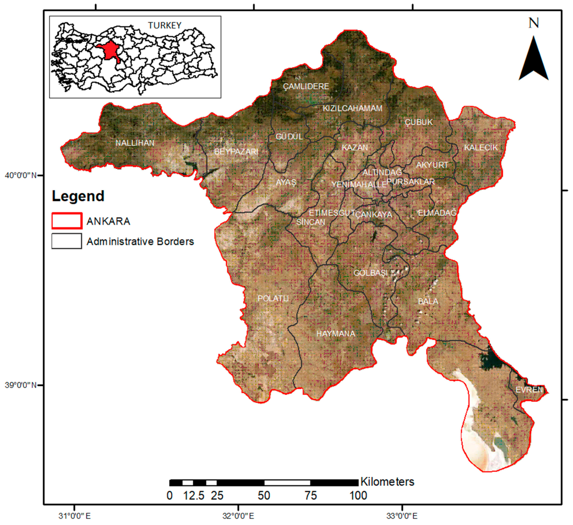
2.1. Study Area

This study was conducted in the Ankara region of Türkiye (Figure 1). Ankara province is the capital of Türkiye and has a geographical area of 25,000 km2. It is the second most populous city in Türkiye, with a population of approximately 5.8 million in 2022, and is located in the central region of Anatolia (39°00′–40°35′ N, 30°40′–33°20′ E). The province has an arid climate, with a mean annual rainfall of approximately 390 mm. More than half of the land in Ankara province is used as agricultural land. Barley, wheat, and sugar beets are the most widely cultivated agricultural products. In addition, pears, apples, onions, melons, watermelons, carrots, tomatoes, cherries, and grapes are produced [58]. Currently, Ankara is a region where grapevines are common. Kalecik district, which is located at the eastern end of Ankara, once was one of the regions in demand, with its grapevines and wine industry, on weekends or holidays, but today it has lost its charm. Small farmers, struggle to make a living, and have to decide whether to keep the vines for the next season or to cut and change crops [56].

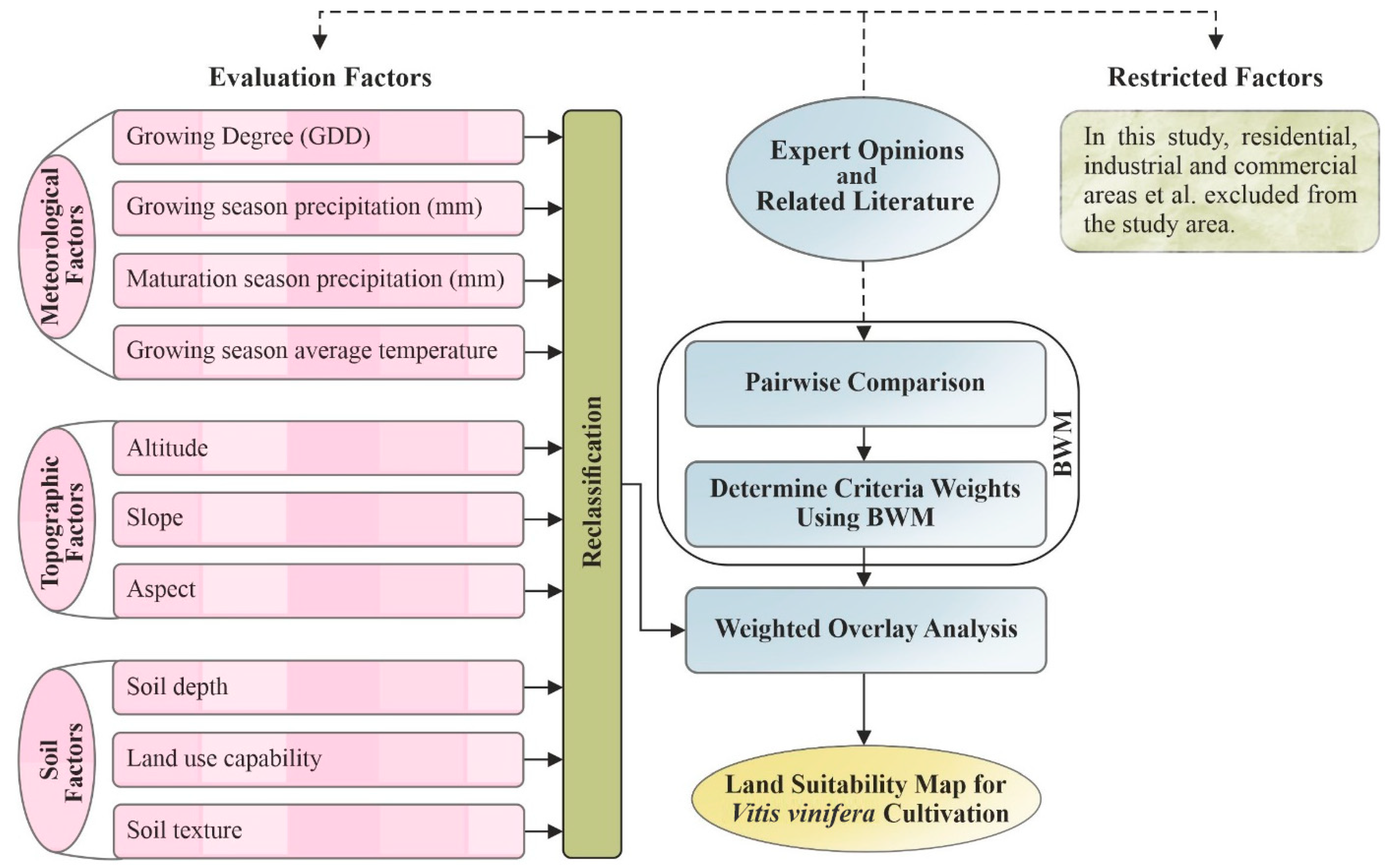
2.2. Model Development

In this study, a model was applied to determine the most suitable areas for Vitis vinifera production in Ankara province. First, the necessary criteria for Vitis vinifera cultivation were defined using a literature review and expert opinions. In addition, environmentally unsuitable areas for Vitis vinifera production were defined. The criteria determined in Section 2.2.2, with references, and the data on unsuitable areas to be excluded from the study were obtained from the sources described in Section 2.2.1. Within the scope of the study, the creation of the basic database, format conversions, analysis, and visualization of these data were carried out using ArcGIS v. 10.5, a GIS software package. The data were reclassified according to various categories to be used in the suitability analysis, and converted from feature to raster formats for weighted overlay analysis. After this stage, with BWM, which is one of the MCDA methods and allows decision-makers to make their evaluations systematically, many criteria determined depending on the characteristics of the region were weighted. Expert academicians’ opinions on Vitis vinifera cultivation were evaluated in both the selection of criteria and the pairwise comparison of these criteria with the BWM. Thus, the weight of each criterion was determined. The determined weight values were transferred to the database, and a suitability map was produced for Vitis vinifera cultivation using the weighted overlay analysis tool in ArcGIS v. 10.5 software. The methodology used in this study is illustrated in Figure 2. This study provides a conservative and sustainable background for determining suitable areas for the cultivation of Vitis vinifera in the province of Ankara.
The following studies have guided the criteria and model used to determine suitable areas for Vitis vinifera cultivation.
The authors of [59] used satellite remote sensing, GIS, and AHP for land suitability analysis of Vitis vinifera production; [46] evaluated land suitability using advanced geospatial data and methods in Michigan; [60], studied the maximum limiting characteristic method based on land suitability assessment for Vitis vinifera using rasterized data of soil and climate in South Korea; [61] performed a suitability analysis by taking into account the criteria of elevation, slope, aspect, land capability, and solar radiation in Izmir/Türkiye; and [48] investigated the key criteria and trends driving Vitis vinifera production and examined how variables changed significantly over time and space.

2.2.1. Data Sources

In this study, meteorological data were obtained from the WorldClim dataset (http://www.worldclim.org/, accessed on 28 January 2022), which evaluates climate data from 1970 to 2000, with a spatial resolution of 30 s (~1 k m 2 ). The raster maps were reevaluated using ArcGIS 10.5 software and converted to raster format by performing meteorological calculations. A digital elevation model was created for the study area using Shuttle Radar Topography Mission (SRTM) data. With the help of this model, elevation, slope, and aspect maps were re-evaluated in a raster format. Soil data for the study area were obtained online using the Agricultural Land Evaluation and Information System software of the Ministry of Agriculture and Forestry of the Republic of Türkiye (TAD Portal) (http://tad.tarim.gov.tr, accessed on 28 January 2022). These data were converted to raster formats required for the study using ArcGIS v. 10.5 software with conversion tools. The CORINE dataset was used to restrict the study area. CORINE is a geographic land cover/use database covering 39 European countries [62].

2.2.2. Description of Evaluation Criteria and Constraints

The exact determination of land suitability is a complex process that requires a variety of types of data. To identify suitable sites, criteria that determine the meteorological, topographical, and soil characteristics of the planned product should be carefully considered. In this way, potential areas where the crop can be grown are identified, and the optimal use of available land resources for sustainable agricultural production is ensured [63]. The important criteria determined for Vitis vinifera in this study are summarized below.

2.3. Meteorological Factors

Agricultural activities depend largely on climatic characteristics and soil properties [46]. Grapevines are widely grown in regions with certain climatic characteristics. Climate change has put significant pressure on all agricultural activities, including viticulture. The climatic data used in this study (Figure 3) are as follows.
(a)
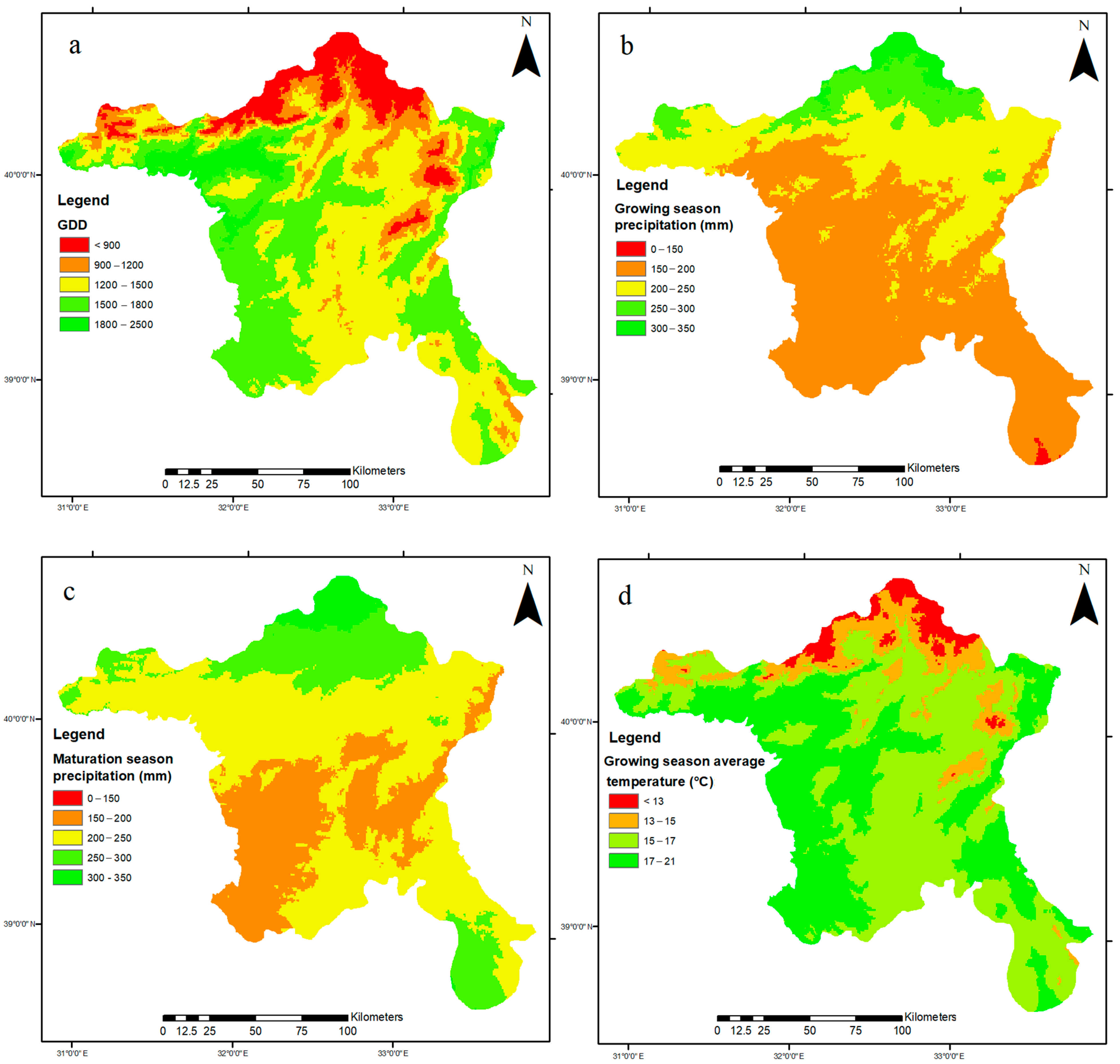
Growing degree days (GDD): GDD, a widely used agro-climatic index, is the sum of temperatures above 10 °C during the development period (between 1 April and 31 October). It starts to develop when the daily average temperature exceeds +10 °C, and continues to develop until the average temperature drops below this value in the autumn. This parameter was used to determine the suitability of the region for grapevines. For grapevine cultivation to be carried out in an economic sense, the GDD must be at least 900 days. Values higher than 2700 were considered too hot for wine grape production [54,64,65].
(b)
Growing season precipitation (mm): During the growth period (between 1 April and 31 October), precipitation is important. Precipitation is required for growth. Irrigation is not required in areas with 600 mm of precipitation. However, irrigation increases the success at 300–600 mm of precipitation. Irrigation is necessary at 300 mm and below.
(c)
Maturation season precipitation (mm): Precipitation can increase the chances of fungal growth and reduce quality at the stages of fruit growth and maturation. Precipitation greater than 900 mm can lead to fungal diseases.
(d)
Growing season average temperature (°C): Below <13 °C is considered very cold, and above 21 °C is considered very hot [66].
In general, vines can endure minimum winter temperatures ranging from −5 °C to −20 °C; below −20 °C there is a high probability of damage. While high temperatures (above 30 °C) increase the maturing potential of fruits, they may mature early because of heat stress [46]. As seen in the data in Table 1, for Ankara, “frequency of cold days” and “number of frost-free days” are not considered as criteria because they are in appropriate values for the study area.
Figure 3. Spatial patterns of meteorological-based variables used in modeling efforts for Ankara.
Agriculture 13 01722 g003

2.4. Topographic Factors

(a)
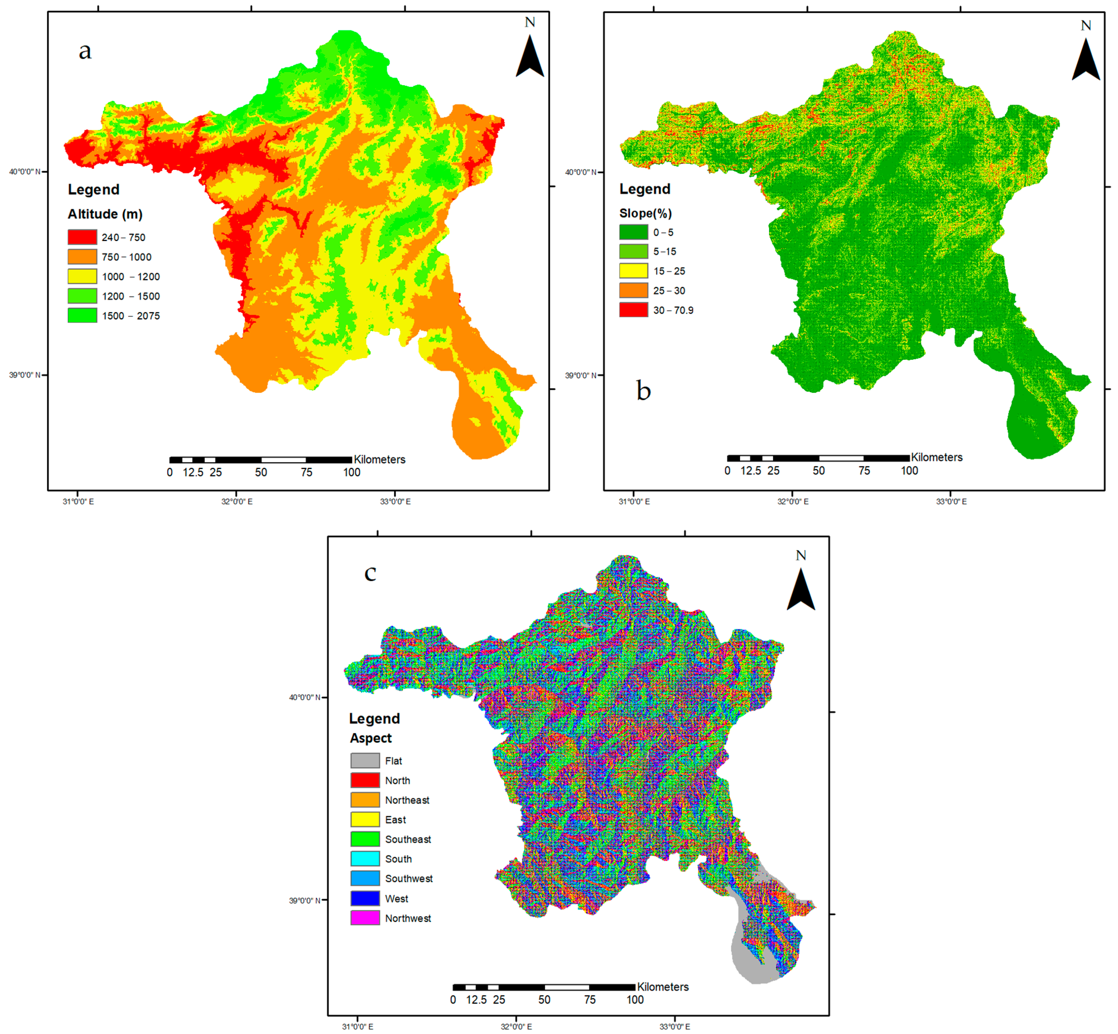
Altitude: The mesoclimate properties of a grapevine are mostly affected by altitude (Figure 4). As a result, atmospheric pressure and temperature decreases, and solar radiation increases. Accordingly, a height of 2500–3000 m in hot regions, and 300 m in cold regions are the limit values for grapevines. Generally, altitudes of 1500–2000 m are accepted as the optimum heights for grapevine, as in Türkiye [67,68,69,70].
(b)
Slope and aspect: In spring and autumn, slope and aspect affect the solar and surface radiation balance. Sloping terrain affects the flow of cold air, and is therefore an important factor in frost events. Because sloping lands hold less water and produce high-quality products, they are important for grapevines. Moderate slopes (5–15%) are considered optimum for wine grape growth in the suitability analysis. In the Northern Hemisphere, south-facing slopes provide heat accumulation through exposure to maximum sunlight. This affects the fruit maturation and quality. The appropriate slopes that should be selected when establishing a grapevine are those facing south, south–east, and south–west directions [45,46,67].
Figure 4. Spatial patterns of topographic-based variables used in modeling efforts for Ankara.
Agriculture 13 01722 g004

2.5. Soil Factor

(a)
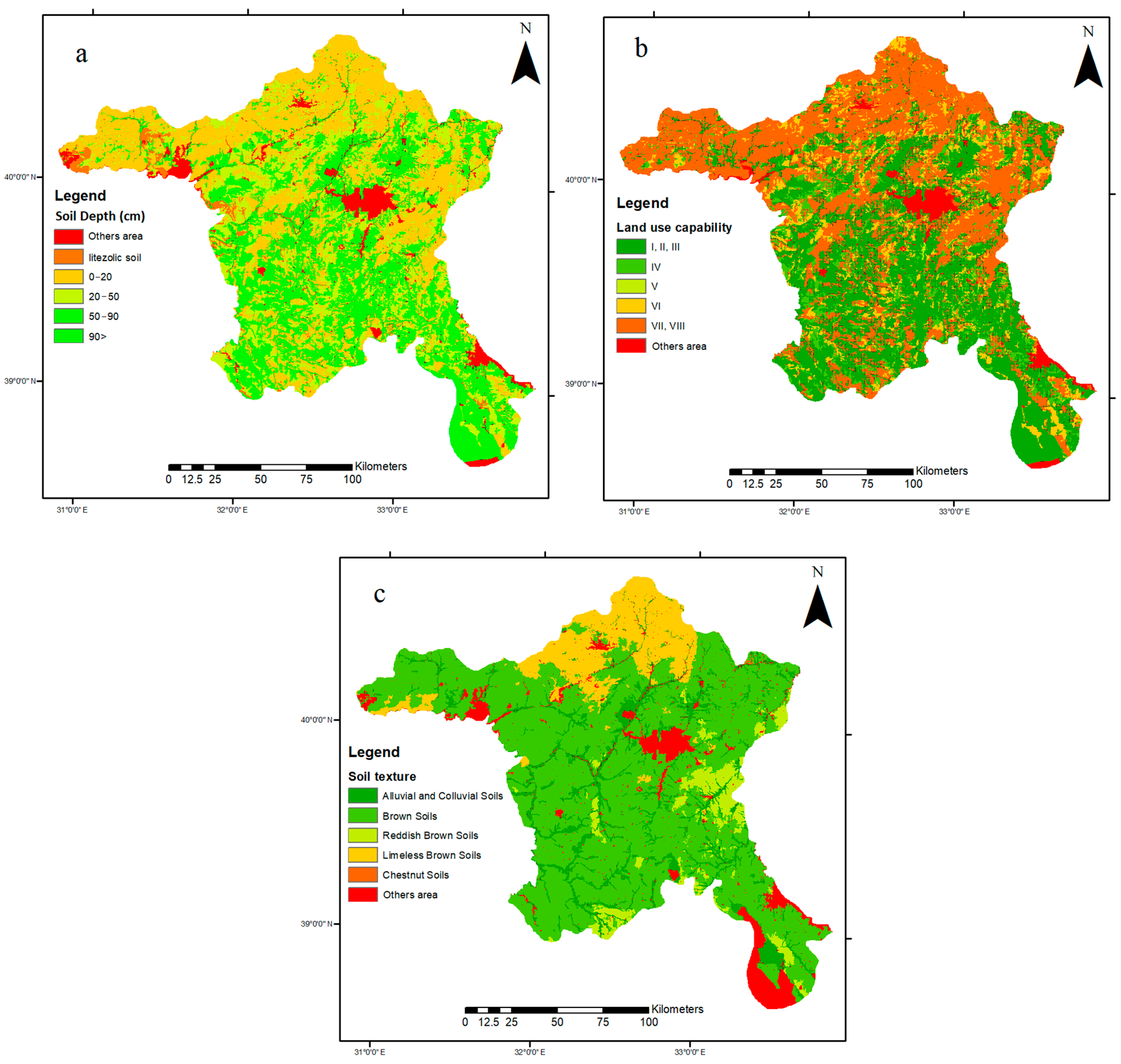
Soil depth: Soil depth is an important criterion for grapevines. The ideal soil for grapevines can be protected. Unlimited soil drainage to a depth of 2–3 m is recommended for most grapevines [40]. Soil depth refers to the maximum depth at which the roots of the vine freely, without obstacles, penetrate the soil, providing plants with physical support, and conditions for the absorption of water and nutrients. In many studies, the soil depth for the production of Vitis vinifera has been stated to be very good above 90–100 cm and unsuitable below 30–40 cm [47,71].
(b)
Land use capability: This classification is mostly used in land use plan studies. In this classification, all land-related data are combined to obtain a combination of agricultural use and conservation measures that will provide the most intensive and appropriate agricultural use of the land without causing soil degradation and erosion. The lands are numbered between classes I and VIII according to the land use capability calculated using various methods. Class I lands are the most valuable lands, which can be cultivated in the most productive, easy, and economical way. Class VIII lands are not suitable for agriculture but can create a natural habitat or be used by people in an urban sense [72]. The land in the study area was divided into eight groups according to their land-use capabilities. In the study area, there was land from class I to class VIII.
(c)
Soil texture: The purpose of classifying soils, which vary from place to place, each with its own characteristics, is to help us remember the important characteristics of soils, to combine our knowledge about soils, to see the relations of soils with each other and with the environment, and to develop information about their properties and suitability for use [72]. Knowing the major soil group the soil belongs to makes it easy to predict the performance of the soil. The soil groups in the Ankara Province are alluvial, chestnut, brown, brown forest, non-calcareous brown forest, non-calcareous brown soils, reddish brown, and colluvial soils (Figure 5). Grapevines usually grow in loamy soil, but they can adapt to many soil types, such as sandy clay, clayey–limy, stony, and loamy. Soils rich in gravel, sandy clay, and organic materials are suitable for vineyard cultivation.
The exclusion of areas that are not suitable for the cultivation of Vitis vinifera by exclusion analysis was an important issue in determining suitable areas for evaluation. Residential areas, industrial and commercial areas, airports, solid waste landfills, military forbidden zones, forests, environmental protection areas, mining areas, urban green areas, and pastures were excluded from the study. The CORINE dataset was used to define land cover. The CORINE is a geographical land cover/land use database that covers 39 European countries [62]. The CORINE dataset for restricted areas was rearranged, converted to raster data format, and is shown in Figure 6. The restricted areas had a total size of 8355.36 km2 and covered 32.63% of the entire study area.

2.6. BWM Weights of the Preferred Criteria

The best worst method (BWM) is a multi-criteria decision-making process based on a systematic pairwise comparison of the decision criteria [73,74]. In the BWM approach, weights are derived for a set of decision criteria using a binary comparison of the best and worst criteria with the other criteria [75]. The most distinctive feature of this method is that, compared to other multi-criteria decision-making methods, it requires less comparison data and produces more consistent and reliable results [76]. When applying BWM, first decision-makers need to identify the most important and least important criteria. Then, pairwise comparisons are made between these two criteria and other criteria [76,77]. To ensure the reliability of pairwise comparisons, the consistency value must be less than 0.10. The weighted values of each criterion, or alternative, are determined as a result of pairwise comparisons.
The BWM has been successfully applied in different scientific fields, such as land suitability assessment for wind farms [75], logistics [78], energy storage systems [79], supply chains [80], supplier selection [81], smart city systems [82], and risk assessment [83]. The application steps of the method are as follows [76]:
  • Step 1: In the first step, the criteria {C1, C2, ……, Cn} to be used in the decision-making problem should be determined.
  • Step 2: Determine the most important criterion (B) and least important criterion (W).
  • Step 3: The rate of preference for the most important (B) criteria over other criteria is determine using a number between 1 and 9 (1 = equally important, 3 = moderately important, 5 = highly important, 7 = much more important, 9 = extremely important). Consequently, the following vector, named best–others (AB), progressing from the best to the others, is obtained:
A B = ( a B 1 ,   a B 2 ,   a B n )
where AB is the pairwise comparison vector of the best criteria and the other criteria, and a B 1 ,   a B 2 ,……   a B n show the comparison scores of the best criteria with the first, second, and nth criteria, respectively.
  • Step 4: The rate of preference of the least important (worst) criteria over other criteria is determined by using a number between 1 and 9. As a result, the following vector, named others–worst (Aw) progressing from the others to worst is reached.
A W = ( a 1 W ,   a 2 W , . , a n W   ) T
where Aw is the pairwise comparison vector of the worst criteria and other criteria a 1 W ,   a 2 W , , a n W   represent the comparison scores of the worst criteria with the first, second, and nth criteria, respectively.
  • Step 5: With the model shown in Equation (3), the optimum weights of the criteria (w1 × w2 ×…× wn) and the consistency indicator (ξL) are calculated. If the consistency indicator is close to “0”, it indicates high consistency [74].
min   ξ L w B w j a B j ξ L   ( for   each   j   criteria ) w j w W a j W ξ L   ( for   each   j   criteria ) j = 1 n w j = 1 w j 0 ,   ( for   each   j   criteria )

3. Results and Discussion

Within the scope of this study, which was carried out to determine suitable areas for Vitis vinifera cultivation with the help of BWM, one of the multi-criteria decision-making methods, the opinions of academics specializing in viticulture and product growers were evaluated in order to determine the necessary criteria and to classify the sub-criteria. The criteria determined by these experts are shown in Table 2, and the pairwise comparisons required to weigh the sub-criteria with BWM were made by the same experts.
Some sub-criteria values were assigned “0” because they were the lower limits for the cultivation of Vitis vinifera, and those criteria were excluded from the classification. For instance, values less than 900 for the GDD criterion, temperatures lower than 13 °C during the growing season, regions where the slope is more than 30%, and soil depth is less than 20 cm are unsuitable for the cultivation of Vitis vinifera. The determining criteria of the study were gathered under three main headings: meteorological, topographic, and soil. Meteorological factors are the most important in determining land suitability for agricultural products [41]. The evaluation of the criteria and the weighting process with BMW were provided with the support of agricultural engineers who were experts in their field and local growers. The BWM is a decision-making technique used to prioritize and rank a set of criteria based on their relative importance. All the criteria for which weights were to be determined were carefully defined by experts in the field, and each criteria was compared with all the other criteria in the set. Each criteria was compared with every other criteria used in the study. For each pair of criteria, we determined the “best” and “worst” based on the criteria they evaluated. After all the pairwise comparisons were made, we counted the number of times each criteria was considered the “best” and the number of times it was considered the “worst”. According to BMW, the main criteria and sub-criteria weights were determined using an Excel file named BWM-Solver-4 developed by Rezaei [74]. The calculated weights are listed in Table 2. These weights were used to integrate variables into the land suitability assessment in the GIS environment and enabled us to produce map results with overlay analysis. A weighted total was used to create Vitis vinifera suitability values and result maps. In the weighting process for each criterion and sub-criterion, all comparisons had CR values less than 0.10. This value indicated that the weight values of the criteria were significant.
According to the total score of each criterion given in Table 2, the three important criteria were determined to be growing degree days (GDD), soil texture, and soil depth. Figure 7 shows the final potential Vitis vinifera cultivation area map that was determined using BWM analysis. The classification was made into four categories, ranging from unsuitable to highly appropriate. In Figure 7, the areas of the suitability classes are shown, which were calculated by converting the raster map to a vector format. When the spatial distribution of the areas suitable for Vitis vinifera cultivation was examined, it was determined that the high suitability areas were 1879.29 km2, the medium suitability areas were 5062.03 km2, the low suitability areas were 4706.20 km2, and the unsuitable areas were 8355.36 km2. The restricted areas in the study area covered an area of 5600.36 km2.
Figure 7 shows that the spatially suitable areas for Vitis vinifera cultivation are concentrated in the south of the study area. Polatlı, Haymana, Bala, and Gölbaşı districts were determined to be the most suitable vineyard cultivation areas. These areas consist of large plains. Sincan, in the middle of the study area, Ayaş and Kazan towards the north, and Kalecik in the east are the districts where suitable areas are more concentrated. Among other factors, the most important reason for the density of unsuitable areas in the northern parts of the study area is the density of the regions where the growing degree days (GDD) value was less than 900.
Ankara is a province where many grape varieties are grown, and especially stands out with wine grape varieties. However, vineyard areas are now smaller compared to the past. Figure 8 shows the status of vineyard areas and grape production between 1939 and 2020 in Ankara. As can be seen, both the production and the amount of cultivated area have decreased significantly compared to the past. The area allocated for wine grape production in 2020 was 867 ha, most of which are located in the Kalecik district (822 ha). Therefore, while there are very large viticulture areas in the province, wine grapes are grown in an area of only 45 ha. Almost half of the vineyard areas in Ankara are located in Kalecik district [84]. Ankara ranks first in Türkiye, especially in pumpkin, onion, cumin, and lettuce production, whereas it ranks second in carrot and spinach production. In addition, 4.05% of Türkiye’s wheat, sugar beet, chickpeas, and barley are grown in Ankara. These crops are grown in most areas suitable for Vitis vinifera. Grape cultivation in the study area was carried out in only 0.68% of the country. Kalecik district was one of the regions that was in demand on weekends or holidays, with its grapevines and wine industry, but today it has lost its charm. Small farmers, who are now struggling to make a living, are looking for solutions by removing grapevines and planting products such as walnuts and almonds, or by turning vineyards into agricultural areas.
Although the number of suitable areas for viticulture was quite high in the study area, it was determined that the number of vineyards in the region was almost non-existent. Almost all of the viticulture is conducted in the Kalecik district. The number of existing vineyards in this region is decreasing daily. The main reason for this is that there is no viticulture support at the policy level in Turkey, and grapes are not included in the list of agricultural products that are encouraged to be planted and financially supported. In addition, reasons such as the misuse of agricultural lands, unconscious cultivation, and drought are among the reasons for the extinction of viticulture.
Considering that the geographical conditions of Ankara are very suitable for viticulture, recognizing grapes among the products that will ensure the sustainability of important agricultural areas may be a good start for the re-expansion of viticulture in the region. Financial and social support for viticulture could be an opportunity for this region. This study forms a basis for policymakers in the implementation of agricultural incentives. Land suitability assessments for different agricultural products can provide financial incentives for the region.

4. Conclusions

Based on this study, to determine the most suitable areas for the cultivation of Vitis vinifera in the Ankara region, 11 different criteria (mainly meteorological) were evaluated with BWM, which is one of the MCDA methods, and the study was completed by combining it with ArcGIS 10.5. The opinions of academics specializing in viticulture and product growers were beneficial in the determining and evaluating the criteria. The preference criteria in this study were determined as follows: under meteorological factors, growing degree days, growing season precipitation, annual maturation season precipitation, precipitation, and growing season average temperature; under topographic factors, altitude, slope, and aspect; under soil factors, soil depth, land use capability, and soil texture. Unsuitable areas for Vitis vinifera cultivation were excluded from the exclusion analysis. Residential, industrial, and commercial areas, airports, solid waste storage areas, military forbidden zones, forests, environmental protection areas, mining areas, urban green areas, and pastures were excluded from the scope of the study. The CORINE dataset was used to define land cover. The total restricted areas was 5600.36 km2 and covered 22% of the total area. When the spatial distribution of the areas suitable for Vitis vinifera cultivation was examined from the resulting map produced, it was seen that 1879.29 km2 (7%) of highly suitability areas, 5062.03 km2 (20%) of medium suitability areas, 4706.20 km2 (18%) of low suitability areas, and 8355.36 km2 (33%) of unsuitable areas were detected. The southern part of the study area was the most important in terms of both size and agricultural suitability. Polatlı, Haymana, Bala, and Gölbaşı districts in the south of the study area, Sincan district in the middle parts, Ayaş and Kazan districts in the north, and Kalecik district in the east were deemed the more suitable areas for Vitis vinifera cultivation. Although the number of suitable areas for viticulture is quite high in Ankara, viticulture is not popular in this region. Almost all of the viticulture in the province is carried out in the Kalecik district. Viticulture has not be developed because of the insufficient level of incentives related to viticulture, misuse of vineyard areas (such as urbanization), and many other problems. Most viticulture activities in the region are conducted on small and scattered lands. This situation is economically unsuitable for viticulture. If land consolidation works are implemented by official institutions to achieve the most appropriate reshaping and arrangement of the lands that are fragmented and dispersed in such a way that agricultural activities have not been sustained for different reasons, and are implemented quickly for viticulture areas in the region, this could contribute to the development of viticulture. To prevent the redivision of these areas for reasons such as inheritance, sale, and urbanization, the laws in force should be actively implemented and monitored. Laws enacted at various times in Turkey that allow for the forgiveness of illegal structures built in certain periods create pressure on agricultural lands and nullify them. Policymakers should take necessary measures so that amnesty laws do not arise again. The agricultural product patterns of the region should be reviewed, planned, and implemented. Thus, social and innovative entrepreneurship related to viticulture should be encouraged.

Author Contributions

Conceptualization, M.U.; methodology, M.U. and E.E.; software, M.U. and E.E.; validation, E.E. and J.J.; formal analysis, M.U.; resources, E.E.; data curation, E.E.; writing—original draft preparation, E.E.; writing—review and editing, J.J.; visualization, M.U., E.E. and J.J.; supervision, M.U.; project administration, E.E. All authors have read and agreed to the published version of the manuscript.

Funding

This research received no external funding.

Institutional Review Board Statement

Not applicable.

Informed Consent Statement

Not applicable.

Data Availability Statement

Data will be made available on request.

Conflicts of Interest

The authors declare that they have no known competing financial interest or personal relationships that could have appeared to influence the work reported in this paper. The funders had no role in the design of the study; in the collection, analyses, or interpretation of data; in the writing of the manuscript; or in the decision to publish the results.

References

  1. Kodirov, R.B.; Temirov, Z.A. Forecasts and demographic development of the population of Fergana Valley regions of Uzbekistan until 2040. J. Geol. Geogr. Geoecol. 2021, 30, 491–499. [Google Scholar] [CrossRef]
  2. Poštek, A.; Kisić, I.; Cerjak, M.; Brezinščak, L. Social aspect of urban agriculture with examples from Croatia. J. Central Eur. Agric. 2021, 22, 881–891. [Google Scholar] [CrossRef]
  3. Tal, A. Making conventional agriculture environmentally friendly: Moving beyond the glorification of organic agriculture and the demonization of conventional agriculture. Sustainability 2018, 10, 1078. [Google Scholar] [CrossRef]
  4. Svircev, A.; Roach, D.; Castle, A. Framing the future with bacteriophages in agriculture. Viruses 2018, 10, 218. [Google Scholar] [CrossRef] [PubMed]
  5. Uyan, M.; Tongur, V.; Ertunc, E. Comparison of different optimization based land reallocation models. Comput. Electron. Agric. 2020, 173, 105449. [Google Scholar] [CrossRef]
  6. Ertunç, E.; Uyan, M.; Tongur, V. Land reallocation model with simulated annealing algorithm. Surv. Rev. 2021, 53, 383–389. [Google Scholar] [CrossRef]
  7. Vincent, D.R.; Deepa, N.; Elavarasan, D.; Srinivasan, K.; Chauhdary, S.H.; Iwendi, C. Sensors Driven AI-Based Agriculture Recommendation Model for Assessing Land Suitability. Sensors 2019, 19, 3667. [Google Scholar] [CrossRef] [PubMed]
  8. Tağıl, Ş. Assessment of Agricultural Land-Use Suitability Levels in the Gulf of Edremit. J. Geogr. 2020, 40, 135–147. [Google Scholar]
  9. Noszczyk, T.; Rutkowska, A.; Hernik, J. Determining Changes in Land Use Structure in Małopolska Using Statistical Methods. Pol. J. Environ. Stud. 2017, 26, 211–220. [Google Scholar] [CrossRef]
  10. Dewan, A.M.; Kabir, H.; Nahar, K.; Rahman, Z. Urbanisation and environmental degradation in Dhaka Metropolitan Area of Bangladesh. Int. J. Environ. Sustain. Dev. 2012, 11, 118. [Google Scholar] [CrossRef]
  11. Zhong, C.; Guo, H.; Swan, I.; Gao, P.; Yao, Q.; Li, H. Evaluating trends, profits, and risks of global cities in recent urban expansion for advancing sustainable development. Habitat Int. 2023, 138, 102869. [Google Scholar] [CrossRef]
  12. Janus, J.; Bożek, P.; Taszakowski, J.; Doroż, A. Decaying villages in the centre of Europe with no population decline: Long-term analysis using historical aerial images and remote sensing data. Habitat Int. 2022, 121, 102520. [Google Scholar] [CrossRef]
  13. Raza, A.; Razzaq, A.; Mehmood, S.S.; Zou, X.; Zhang, X.; Lv, Y.; Xu, J. Impact of Climate Change on Crops Adaptation and Strategies to Tackle Its Outcome: A Review. Plants 2019, 8, 34. [Google Scholar] [CrossRef] [PubMed]
  14. Corwin, D.L. Climate change impacts on soil salinity in agricultural areas. Eur. J. Soil Sci. 2021, 72, 842–862 . [Google Scholar] [CrossRef]
  15. Morales, F.F.; de Vries, W.T. Establishment of Natural Hazards Mapping Criteria Using Analytic Hierarchy Process (AHP). Front. Sustain. 2021, 2, 667105. [Google Scholar] [CrossRef]
  16. Du, Y.; Cui, B.; Zhang, Q.; Wang, Z.; Sun, J.; Niu, W. Effects of manure fertilizer on crop yield and soil properties in China: A meta-analysis. CATENA 2020, 193, 104617. [Google Scholar] [CrossRef]
  17. Orhan, O. Land suitability determination for citrus cultivation using a GIS-based multi-criteria analysis in Mersin, Turkey. Comput. Electron. Agric. 2021, 190, 106433. [Google Scholar] [CrossRef]
  18. Akpoti, K.; Kabo-Bah, A.T.; Zwart, S.J. Agricultural land suitability analysis: State-of-the-art and outlooks for integration of climate change analysis. Agric. Syst. 2019, 173, 172–208. [Google Scholar] [CrossRef]
  19. Fan, M.; Kang, M.; Wang, X.; Hua, J.; He, C.; Wang, F. Parallel crop planning based on price forecast. Int. J. Intell. Syst. 2022, 37, 4772–4793. [Google Scholar] [CrossRef]
  20. Maleki, F.; Kazemi, H.; Siahmarguee, A.; Kamkar, B. Development of a land use suitability model for saffron (Crocus sativus L.) cultivation by multi-criteria evaluation and spatial analysis. Ecol. Eng. 2017, 106, 140–153. [Google Scholar] [CrossRef]
  21. FAO. A Framework for Land Evaluation; FAO Soils Bulletin: Rome, Italy, 1976; p. 32. [Google Scholar]
  22. Tercan, E.; Dereli, M.A. Development of a land suitability model for citrus cultivation using GIS and multi-criteria assessment techniques in Antalya province of Turkey. Ecol. Indic. 2020, 117, 106549. [Google Scholar] [CrossRef]
  23. Janus, J.; Taszakowski, J. Spatial differentiation of indicators presenting selected barriers in the productivity of agricultural areas: A regional approach to setting land consolidation priorities. Ecol. Indic. 2018, 93, 718–729. [Google Scholar] [CrossRef]
  24. Kazemi, H.; Akinci, H. A land use suitability model for rainfed farming by Multi-criteria Decision-making Analysis (MCDA) and Geographic Information System (GIS). Ecol. Eng. 2018, 116, 1–6. [Google Scholar] [CrossRef]
  25. Wójcik-Leń, J.; Leń, P.; Sobolewska-Mikulska, K. The proposed algorithm for identifying agricultural problem areas for the needs of their reasonable management under land consolidation works. Comput. Electron. Agric. 2018, 152, 333–339. [Google Scholar] [CrossRef]
  26. Uyan, M. Arazi Düzenlemesi Çalışmalarında Mekânsal Karar Destek Sistemleri Kurulumu ve Uygulaması. Ph.D. Thesis, Selcuk University, Graduate School of Natural Sciences, Konya, Turkey, 2011. (In Turkish). [Google Scholar]
  27. Kahsay, A.; Haile, M.; Gebresamuel, G.; Mohammed, M. GIS-based multi-criteria model for land suitability evaluation of rainfed teff crop production in degraded semi-arid highlands of Northern Ethiopia. Model. Earth Syst. Environ. 2018, 4, 1467–1486. [Google Scholar] [CrossRef]
  28. Mohamed, A.H.; Shendi, M.M.; Awadalla, A.A.; Mahmoud, A.G.; Semida, W.M. Land suitability modeling for newly reclaimed area using GIS-based multi-criteria decision analysis. Environ. Monit. Assess. 2019, 191, 535. [Google Scholar] [CrossRef] [PubMed]
  29. Šiljeg, A.; Jurišić, M.; Radočaj, D.; Videković, M. Suitability modeling of agricultural land for barley cultivation using the multicriteria GIS analysis. Poljoprivreda 2020, 26, 40–47. [Google Scholar] [CrossRef]
  30. Ozsahin, E.; Ozdes, M. Agricultural land suitability assessment for agricultural productivity based on GIS modeling and multi-criteria decision analysis: The case of Tekirdağ province. Environ. Monit. Assess. 2022, 194, 41. [Google Scholar] [CrossRef]
  31. Musakwa, W. Identifying land suitable for agricultural land reform using GIS-MCDA in South Africa. Environ. Dev. Sustain. 2018, 20, 2281–2299. [Google Scholar] [CrossRef]
  32. Wójcik-Leń, J.; Postek, P.; Stręk, Ż.; Leń, P. Proposed algorithm for the identification of land for consolidation with regard to spatial variability of soil quality. Land Use Policy 2020, 94, 104570. [Google Scholar] [CrossRef]
  33. Wotlolan, D.L.; Lowry, J.H.; Wales, N.A.; Glencross, K. Land suitability evaluation for multiple crop agroforestry planning using GIS and multi-criteria decision analysis: A case study in Fiji. Agrofor. Syst. 2021, 95, 1519–1532. [Google Scholar] [CrossRef]
  34. Seyedmohammadi, J.; Sarmadian, F.; Jafarzadeh, A.A.; McDowell, R.W. Development of a model using matter element, AHP and GIS techniques to assess the suitability of land for agriculture. Geoderma 2019, 352, 80–95. [Google Scholar] [CrossRef]
  35. Ustaoglu, E.; Sisman, S.; Aydınoglu, A. Determining agricultural suitable land in peri-urban geography using GIS and Multi Criteria Decision Analysis (MCDA) techniques. Ecol. Model. 2021, 455, 109610. [Google Scholar] [CrossRef]
  36. Šiljeg, A.; Cavrić, B.; Šiljeg, S.; Marić, I.; Barada, M. Land suitability zoning for ecotourism planning and development of Dikgatlhong Dam, Botswana. Geogr. Pannon. 2019, 23, 76–86. [Google Scholar] [CrossRef]
  37. Kheybari, S.; Javdanmehr, M.; Rezaie, F.M.; Rezaei, J. Corn cultivation location selection for bioethanol production: An application of BWM and extended PROMETHEE II. Energy 2021, 228, 120593. [Google Scholar] [CrossRef]
  38. Deng, F.; Li, X.; Wang, H.; Zhang, M.; Li, R.; Li, X. GIS-based assessment of land suitability for alfalfa cultivation: A case study in the dry continental steppes of northern China. Span. J. Agric. Res. 2014, 12, 364–375. [Google Scholar] [CrossRef]
  39. Mendas, A.; Delali, A. Integration of Multi Criteria Decision Analysis in GIS to develop land suitability for agriculture: Application to durum wheat cultivation in the region of Mleta in Algeria. Comput. Electron. Agric. 2012, 83, 117–126. [Google Scholar] [CrossRef]
  40. Everest, T. Suitable site selection for pistachio (Pistacia vera) by using GIS and multi-criteria decision analyses (a case study in Turkey). Environ. Dev. Sustain. 2021, 23, 7686–7705. [Google Scholar] [CrossRef]
  41. Selim, S.; Koc-San, D.; Selim, C.; San, B.T. Site selection for avocado cultivation using GIS and multi-criteria decision analyses: Case study of Antalya, Turkey. Comput. Electron. Agric. 2018, 154, 450–459. [Google Scholar] [CrossRef]
  42. Zabihi, H.; Alizadeh, M.; Langat, P.K.; Karami, M.; Shahabi, H.; Ahmad, A.; Said, M.N.; Lee, S. GIS Multi-Criteria Analysis by Ordered Weighted Averaging (OWA): Toward an Integrated Citrus Management Strategy. Sustainability 2019, 11, 1009. [Google Scholar] [CrossRef]
  43. Seyedmohammadi, J.; Sarmadian, F.; Jafarzadeh, A.A.; Ghorbani, M.A.; Shahbazi, F. Application of SAW, TOPSIS and fuzzy TOPSIS models in cultivation priority planning for maize, rapeseed and soybean crops. Geoderma 2018, 310, 178–190. [Google Scholar] [CrossRef]
  44. Doan, M.N.T.; Dao, C.T.; Nguyen, N.T.; Nguyen, H.T.T.; Tran, H.L.T.; Le, S.T.; Van Vu, M. Research on the Potential Environmental Zonation of Red Flesh Dragon Fruit in Vinh Phuc Province. In From Science to Society; Springer: Cham, Switzerland, 2018; pp. 13–24. [Google Scholar]
  45. Badr, G.; Hoogenboom, G.; Moyer, M.; Keller, M.; Rupp, R.; Davenport, J. Spatial suitability assessment for vineyard site selection based on fuzzy logic. Precis. Agric. 2018, 19, 1027–1048. [Google Scholar] [CrossRef]
  46. Wanyama, D.; Bunting, E.L.; Goodwin, R.; Weil, N.; Sabbatini, P.; Andresen, J.A. Modeling Land Suitability for Vitis vinifera in Michigan Using Advanced Geospatial Data and Methods. Atmosphere 2020, 11, 339. [Google Scholar] [CrossRef]
  47. Alsafadi, K.; Mohammed, S.; Habib, H.; Kiwan, S.; Hennawi, S.; Sharaf, M. An integration of bioclimatic, soil, and topographic indicators for viticulture suitability using multi-criteria evaluation: A case study in the Western slopes of Jabal Al Arab—Syria. Geocarto Int. 2020, 35, 1466–1488. [Google Scholar] [CrossRef]
  48. Bunting, E.L.; Wanyama, D.; Goodwin, R.; Weil, N.; Sabbatini, P.; Andresen, J. Vitis vinifera Production in Michigan: Factors and Trends Driving Cultivation Patterns. Front. Plant Sci. 2021, 12, 704690. [Google Scholar] [CrossRef] [PubMed]
  49. Cislaghi, A.; Bordoni, M.; Meisina, C.; Bischetti, G.B. Soil reinforcement provided by the root system of grapevines: Quantification and spatial variability. Ecol. Eng. 2017, 109, 169–185. [Google Scholar] [CrossRef]
  50. Capó-Bauçà, S.; Marqués, A.; Llopis-Vidal, N.; Bota, J.; Baraza, E. Long-term establishment of natural green cover provides agroecosystem services by improving soil quality in a Mediterranean vineyard. Ecol. Eng. 2019, 127, 285–291. [Google Scholar] [CrossRef]
  51. Jovanović-Cvetković, T.; Sredojević, M.; Natić, M.; Grbić, R.; Akšić, M.F.; Ercisli, S.; Cvetković, M. Exploration and Comparison of the Behavior of Some Indigenous and International Varieties (Vitis vinifera L.) Grown in Climatic Conditions of Herzegovina: The Influence of Variety and Vintage on Physico-Chemical Characteristics of Grapes. Plants 2023, 12, 695. [Google Scholar] [CrossRef]
  52. Piña-Rey, A.; Ribeiro, H.; Fernández-González, M.; Abreu, I.; Rodríguez-Rajo, F.J. Phenological Model Predicting Budding and Flowering Dates of Four Vitis vinifera L. Cultivars Cultivated in DO. Ribeiro (North-West Spain). Plants 2021, 10, 502. [Google Scholar] [CrossRef]
  53. Parker, A.K.; de Cortázar-Atauri, I.G.; Gény, L.; Spring, J.L.; Destrac, A.; Schultz, H.; Molitor, D.; Lacombe, T.; Graça, A.; Monamy, C.; et al. Temperature-based grapevine sugar ripeness modelling for a wide range of Vitis vinifera L. cultivars. Agric. For. Meteorol. 2020, 285, 107902. [Google Scholar] [CrossRef]
  54. Ateş, F.; Uysal, H.; Merken, Ö.; Çetinkaya, Ö.Ü.N.; Eşitken, A.; Altındişli, A. Organik üzüm yetiştiriciliği. In TAGEM; Atatürk Horticultural Central Research Institute: Yalova, Türkiye, 2021; No 107. (In Turkish) [Google Scholar]
  55. Candar, S.; Uysal, T.; Ayaz, A.; Akdemir, U.; Korkutal, I.; Bahar, E. Viticulture Tradition in Turkey. Tekirdag Vitic. Res. Inst. 2021, 1, 39–54. [Google Scholar] [CrossRef]
  56. Ribeiro, J.D.; Ribeiro, D.C.; Duarte, J.S. A Legacy of Grape: A Socio-Cultural and Spatial Analysis of Ankara’s Wine Production History. J. Ank. Stud. 2020, 8, 215–251. [Google Scholar] [CrossRef]
  57. Kheybari, S.; Ishizaka, A. The behavioural best-worst method. Expert Syst. Appl. 2022, 209, 118265. [Google Scholar] [CrossRef]
  58. TOB. Ankara İli Tarımsal Yatırım Rehberi. 2015. Available online: https://ankara.tarimorman.gov.tr/Belgeler/pdf/yatirimrehberi.pdf (accessed on 17 January 2023). (In Turkish)
  59. Arab, S.T.; Salari, T.; Noguchi, R.; Ahamed, T. Land Suitability Analysis for Grape (Vitis vinifera L.) Production Using Satellite Remote Sensing, GIS, and Analytical Hierarchy Process. In Remote Sensing Application: Regional Perspectives in Agriculture and Forestry; Springer Nature: Singapore, 2022; pp. 149–184. [Google Scholar]
  60. Kim, H.; Koo, K.A.; Shim, K.M. The maximum limiting characteristic method-based land suitability assessment for peaches (Prunus persica) and grapes (Vitis vinifera L.) using rasterized data of soil and climate on agricultural land in South Korea. Korean J. Agric. For. Meteorol. 2019, 21, 286–296. [Google Scholar]
  61. Salata, S.; Ozkavaf-Senalp, S.; Velibeyoğlu, K.; Elburz, Z. Land Suitability Analysis for Vineyard Cultivation in the Izmir Metropolitan Area. Land 2022, 11, 416. [Google Scholar] [CrossRef]
  62. Tutić, D.; Štanfel, M.; Horvat, M.T. Multi-Criteria Land Evaluation of Suitability for the Sport of Foot Orienteering: A Case Study of Croatia and Slovenia. ISPRS Int. J. Geo-Inf. 2018, 7, 227. [Google Scholar] [CrossRef]
  63. Bilgilioğlu, S.S. Land suitability assessment for Olive cultivation using GIS and multi-criteria decision-making in Mersin City, Turkey. Arab. J. Geosci. 2021, 14, 2434. [Google Scholar] [CrossRef]
  64. Ortega-Farias, S.; Riveros-Burgos, C. Modeling phenology of four grapevine cultivars (Vitis vinifera L.) in Mediterranean climate conditions. Sci. Hortic. 2019, 250, 38–44. [Google Scholar] [CrossRef]
  65. Charalampopoulos, I.; Polychroni, I.; Psomiadis, E.; Nastos, P. Spatiotemporal estimation of the olive and vine cultivations’ growing degree days in the Balkans region. Atmosphere 2021, 12, 148. [Google Scholar] [CrossRef]
  66. Ruml, M.; Vuković, A.; Vujadinović, M.; Djurdjević, V.; Ranković-Vasić, Z.; Atanacković, Z.; Sivčev, B.; Marković, N.; Matijašević, S.; Petrović, N. On the use of regional climate models: Implications of climate change for viticulture in Serbia. Agric. For. Meteorol. 2012, 158, 53–62. [Google Scholar] [CrossRef]
  67. Bahar, E.; Korkutal, İ.; Öner, H. Bağcılıkta terroir unsurları. Bahçe 2018, 47, 57–70. (In Turkish) [Google Scholar]
  68. Gouvinhas, I.; Pinto, R.; Santos, R.; Saavedra, M.J.; Barros, A.I. Enhanced phytochemical composition and biological activities of grape (Vitis vinifera L.) Stems growing in low altitude regions. Sci. Hortic. 2020, 265, 109248. [Google Scholar] [CrossRef]
  69. Poudel, P.R.; Koyama, K.; Goto-Yamamoto, N. Evaluating the influence of temperature on proanthocyanidin biosynthesis in developing grape berries (Vitis vinifera L.). Mol. Biol. Rep. 2020, 47, 3501–3510. [Google Scholar] [CrossRef] [PubMed]
  70. De Rességuier, L.; Mary, S.; Le Roux, R.; Petitjean, T.; Quénol, H.; van Leeuwen, C. Temperature Variability at Local Scale in the Bordeaux Area. Relations With Environmental Factors and Impact on Vine Phenology. Front. Plant Sci. 2020, 11, 515. [Google Scholar] [CrossRef] [PubMed]
  71. Dortzbach, D.; Loss, A.; Nascimento Machado, L.; Pereira, M.G.; dos Anjos, L.H.C. Adaptation of the land agricultural suitability evaluation system to high-altitude vineyards. Rev. Cienc. Agrícolas 2019, 36, 58–73. [Google Scholar] [CrossRef]
  72. TOB. Toprak Ve Arazi Sınıflaması Standartları Teknik Talimatı. 2022. Available online: https://www.tarimorman.gov.tr (accessed on 28 January 2022). (In Turkish)
  73. Rezaei, J.; Wang, J.; Tavasszy, L. Linking supplier development to supplier segmentation using Best Worst Method. Expert Syst. Appl. 2015, 42, 9152–9164. [Google Scholar] [CrossRef]
  74. Rezaei, J. Best-worst multi-criteria decision-making method: Some properties and a linear model. Omega 2016, 64, 126–130. [Google Scholar] [CrossRef]
  75. Tercan, E. Land suitability assessment for wind farms through best-worst method and GIS in Balıkesir province of Turkey. Sustain. Energy Technol. Assess. 2021, 47, 101491. [Google Scholar] [CrossRef]
  76. Rezaei, J. Best-worst multi-criteria decision-making method. Omega 2015, 53, 49–57. [Google Scholar] [CrossRef]
  77. Ertunç, E.; Uyan, M. Land valuation with Best Worst Method in land consolidation projects. Land Use Policy 2022, 122, 106360. [Google Scholar] [CrossRef]
  78. Rezaei, J.; van Roekel, W.S.; Tavasszy, L. Measuring the relative importance of the logistics performance index indicators using Best Worst Method. Transp. Policy 2018, 68, 158–169. [Google Scholar] [CrossRef]
  79. Zhao, H.; Guo, S.; Zhao, H. Comprehensive assessment for battery energy storage systems based on fuzzy-MCDM considering risk preferences. Energy 2019, 168, 450–461. [Google Scholar] [CrossRef]
  80. Aboutorab, H.; Saberi, M.; Asadabadi, M.R.; Hussain, O.; Chang, E. ZBWM: The Z-number extension of Best Worst Method and its application for supplier development. Expert Syst. Appl. 2018, 107, 115–125. [Google Scholar] [CrossRef]
  81. Gupta, H.; Barua, M.K. Supplier selection among SMEs on the basis of their green innovation ability using BWM and fuzzy TOPSIS. J. Clean. Prod. 2017, 152, 242–258. [Google Scholar] [CrossRef]
  82. Yadav, G.; Mangla, S.K.; Luthra, S.; Rai, D.P. Developing a sustainable smart city framework for developing economies: An Indian context. Sustain. Cities Soc. 2019, 47, 101462. [Google Scholar] [CrossRef]
  83. Torabi, S.A.; Giahi, R.; Sahebjamnia, N. An enhanced risk assessment framework for business continuity management systems. Saf. Sci. 2016, 89, 201–218. [Google Scholar] [CrossRef]
  84. Çaltı, N. Kalecik Karası Bağ Alanları İçin İklim Değişikliği Uyum Eylem Planı. Master’s Thesis, Ankara Üniversitesi Sosyal Bilimler Enstitüsü, Ankara, Turkey, 2022. (In Turkish). [Google Scholar]
Figure 1. Location of Ankara in Türkiye.
Agriculture 13 01722 g001
Figure 2. General framework of Vitis vinifera land suitability mapping in Ankara.
Agriculture 13 01722 g002
Figure 5. Spatial patterns of soil-based variables used in modeling efforts for Ankara.
Agriculture 13 01722 g005
Figure 6. Areas unsuitable for Vitis vinifera cultivation in Ankara.
Agriculture 13 01722 g006
Figure 7. Final land suitability map for Vitis vinifera cultivation in Ankara.
Agriculture 13 01722 g007
Figure 8. Vineyard area and grape production 1939–2020 in Ankara [84].
Agriculture 13 01722 g008
Table 1. Temperature data of Ankara province (measurement period: 1927–2020).
AnkaraJanFebMarAprMayJuneJulyAugustSepOctNovDecAvg.
Average
temperature (°C)
0.21.75.711.216.020.023.423.418.913.27.22.511.9
Average max. temperature (°C)4.26.511.517.422.426.730.330.426.120.013.06.517.9
Average min. temperature (°C)−3.3−2.30.75.39.712.915.816.011.87.22.5−0.86.3
Table 2. Calculated weights of criteria and sub-criteria used to determine suitable areas for grapevine cultivation using BWM.
GoalObj.WeightCRCriteriaWeightCRSub-CriteriaWeightCR∑Weight
LAND SUITABILITY for VITIS VINIFERAMeteorological Factors0.490.046Growing degree days (GDD)0.540.072<9000.000.0770.000
900–12000.040.011
1200–15000.500.132
1500–18000.340.090
1800–25000.120.032
Growing season
precipitation (mm)
0.05<1500.030.0790.001
150–2000.060.001
200–2500.100.002
250–3000.300.007
300–3500.510.013
Maturation season
precipitation (mm)
0.22<1500.490.0870.053
150–2000.260.028
200–2500.140.015
250–3000.080.008
300–3500.030.003
Annual precipitation (mm)0.06<4000.030.0900.001
400–5000.060.002
500–5500.140.004
550–6000.270.008
600–7000.510.015
Growing season
average temperature (°C)
0.13<130.000.0830.000
13–150.090.006
15–170.200.013
17–210.710.045
Topographic Factors0.20Altitude0.060.091240–7500.030.0940.000
750–10000.060.001
1000–12000.140.002
1200–15000.310.004
1500–20750.460.006
Slope (%)0.300–50.270.0960.016
0–150.570.034
15–250.120.007
25–300.040.003
>300.000.000
Aspect0.63Flat0.100.0960.013
South, southeast, southwest0.630.079
East, west0.190.024
Northeast, northwest0.040.005
North0.040.005
Soil Factors0.31Soil depth0.410.0250–200.000.0710.000
20–500.070.009
50–900.150.020
>900.780.099
Land use capability0.12I–III 0.740.0230.028
IV0.100.004
V0.080.003
VI0.070.003
VII–VIII0.000.000
Soil texture0.48Alluvial and colluvial0.460.0660.069
Brown0.260.039
Reddish-brown0.150.023
Limeless-brown0.080.012
Chestnut0.040.006
Disclaimer/Publisher’s Note: The statements, opinions and data contained in all publications are solely those of the individual author(s) and contributor(s) and not of MDPI and/or the editor(s). MDPI and/or the editor(s) disclaim responsibility for any injury to people or property resulting from any ideas, methods, instructions or products referred to in the content.

