Geographical Types and Driving Mechanisms of Rural Hollowing-Out in the Yellow River Basin

Abstract
:1. Introduction
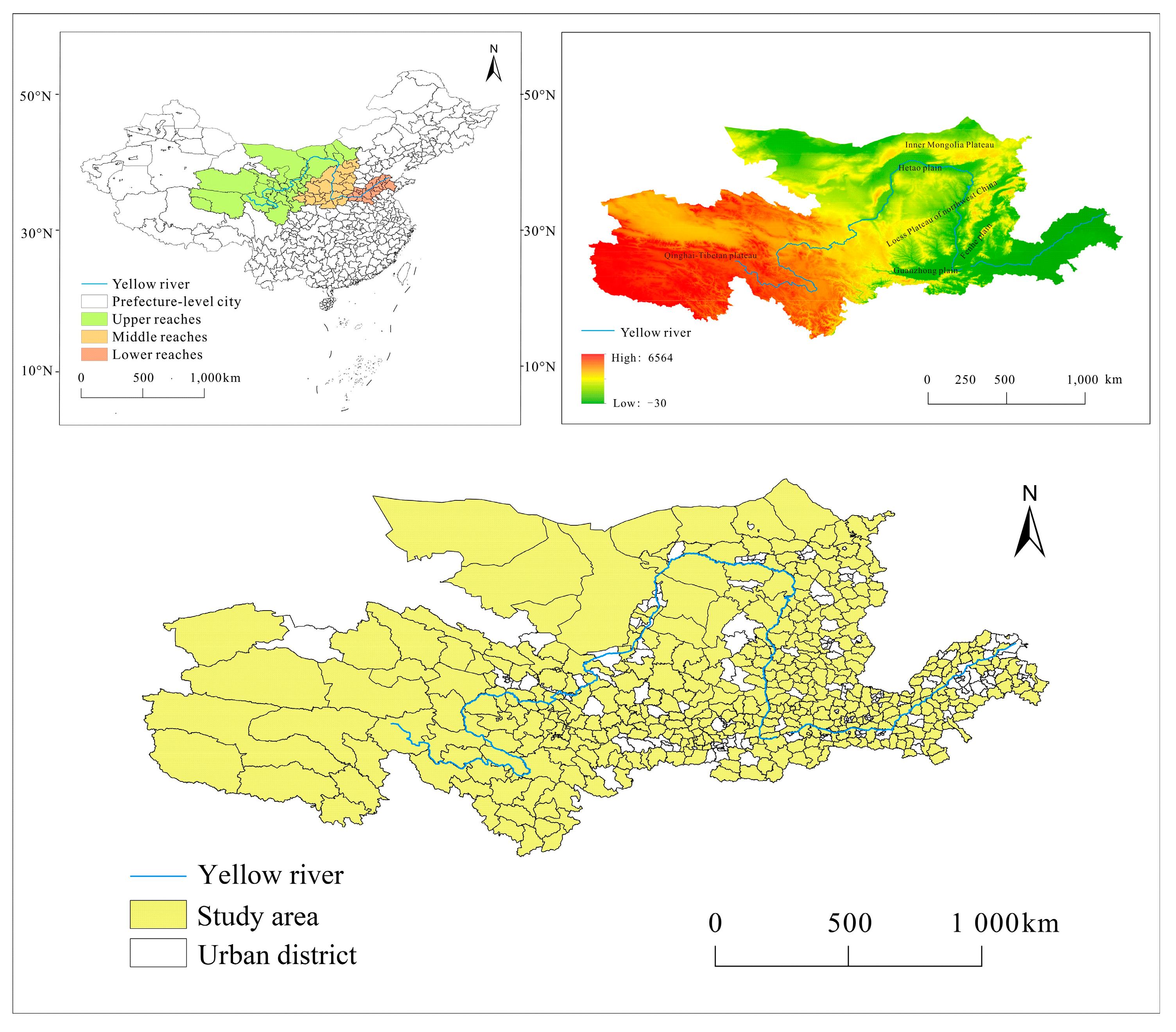
2. Study Area
3. Methodology
3.1. Data
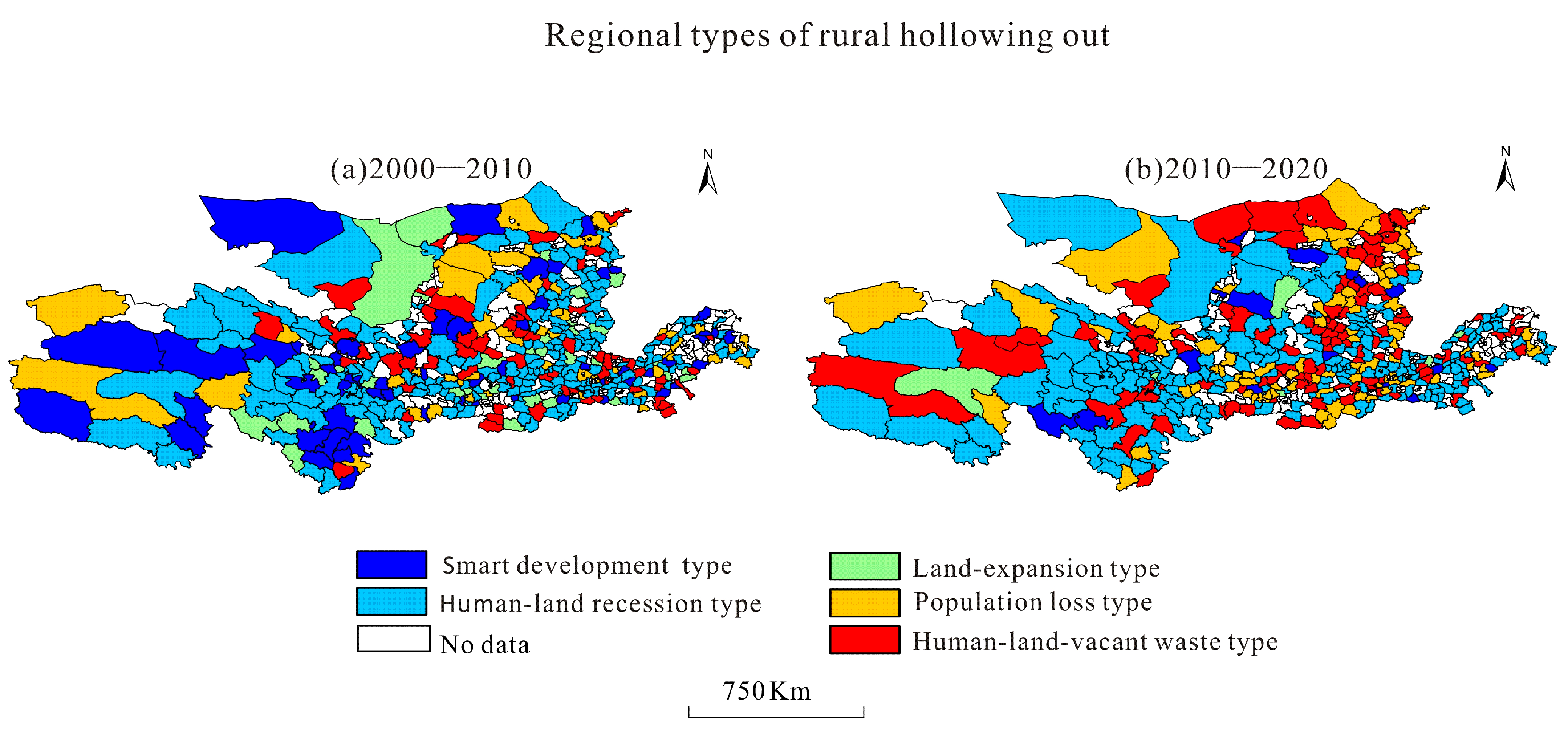
3.2. Methodology for Classifying Geographical Types of Rural Hollowing-Out
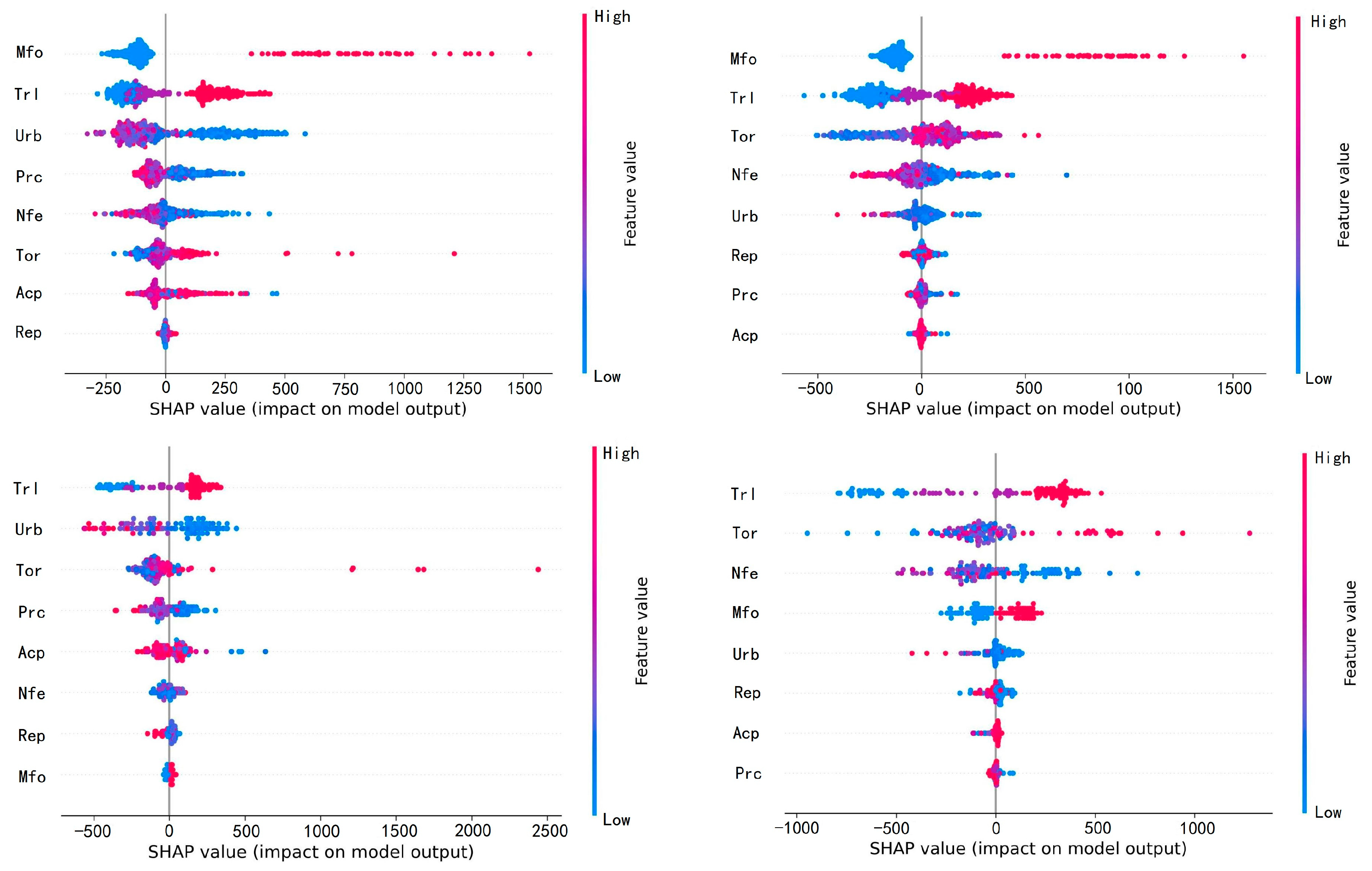
3.3. Indicator System of Influencing Factors
3.4. XGBoost Model and SHAP-Based Interpretability
4. Results
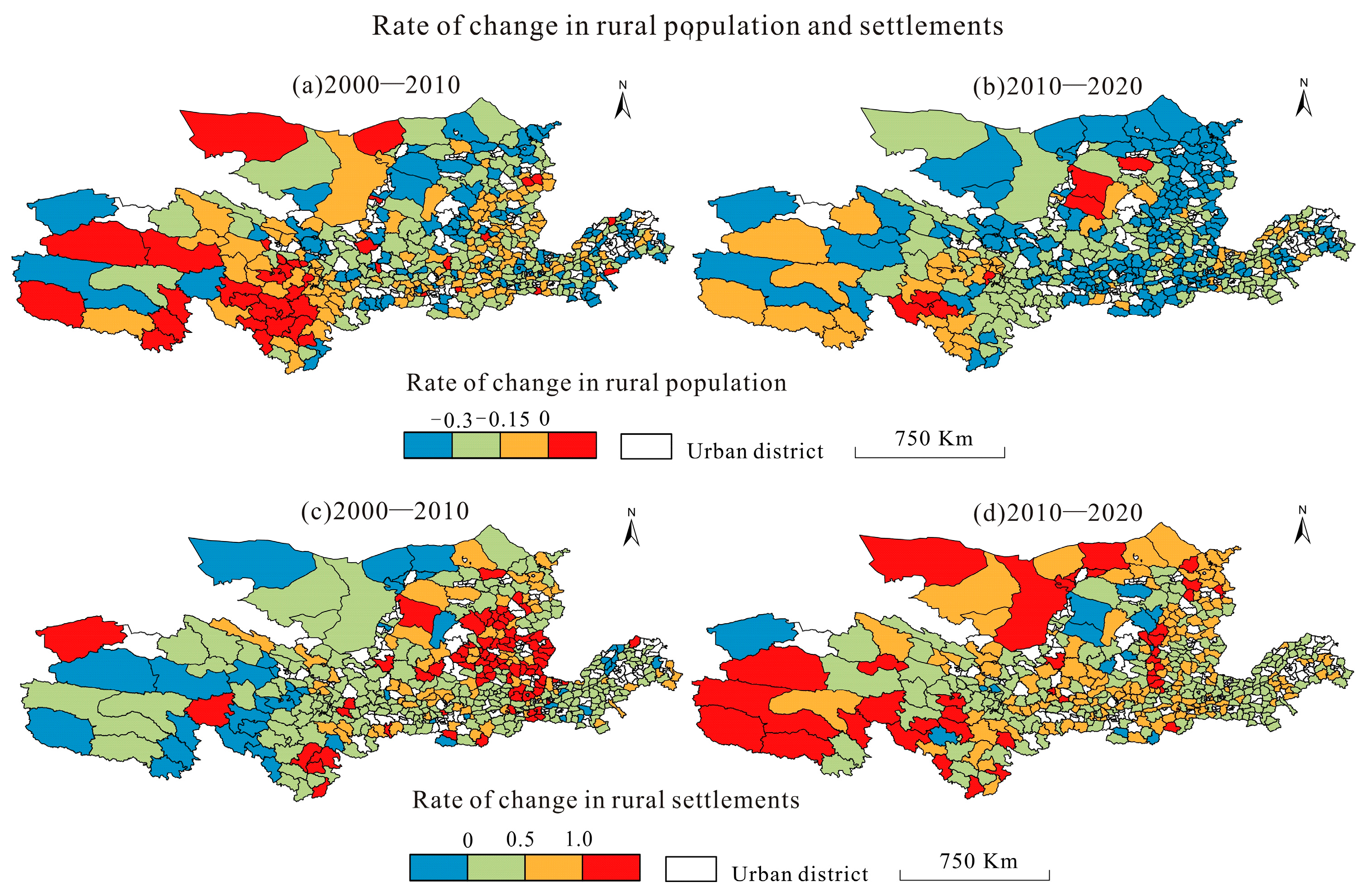
4.1. Characteristics of the Spatio-Temporal Evolution of the Rural Population and Residential Land Use
4.2. Characteristics of Geographical Types of Rural Hollowing-Out
4.2.1. General Characteristics of the Geographical Types of Rural Hollowing-Out
4.2.2. Spatio-Temporal Patterns of Types of Rural Hollowing-Out
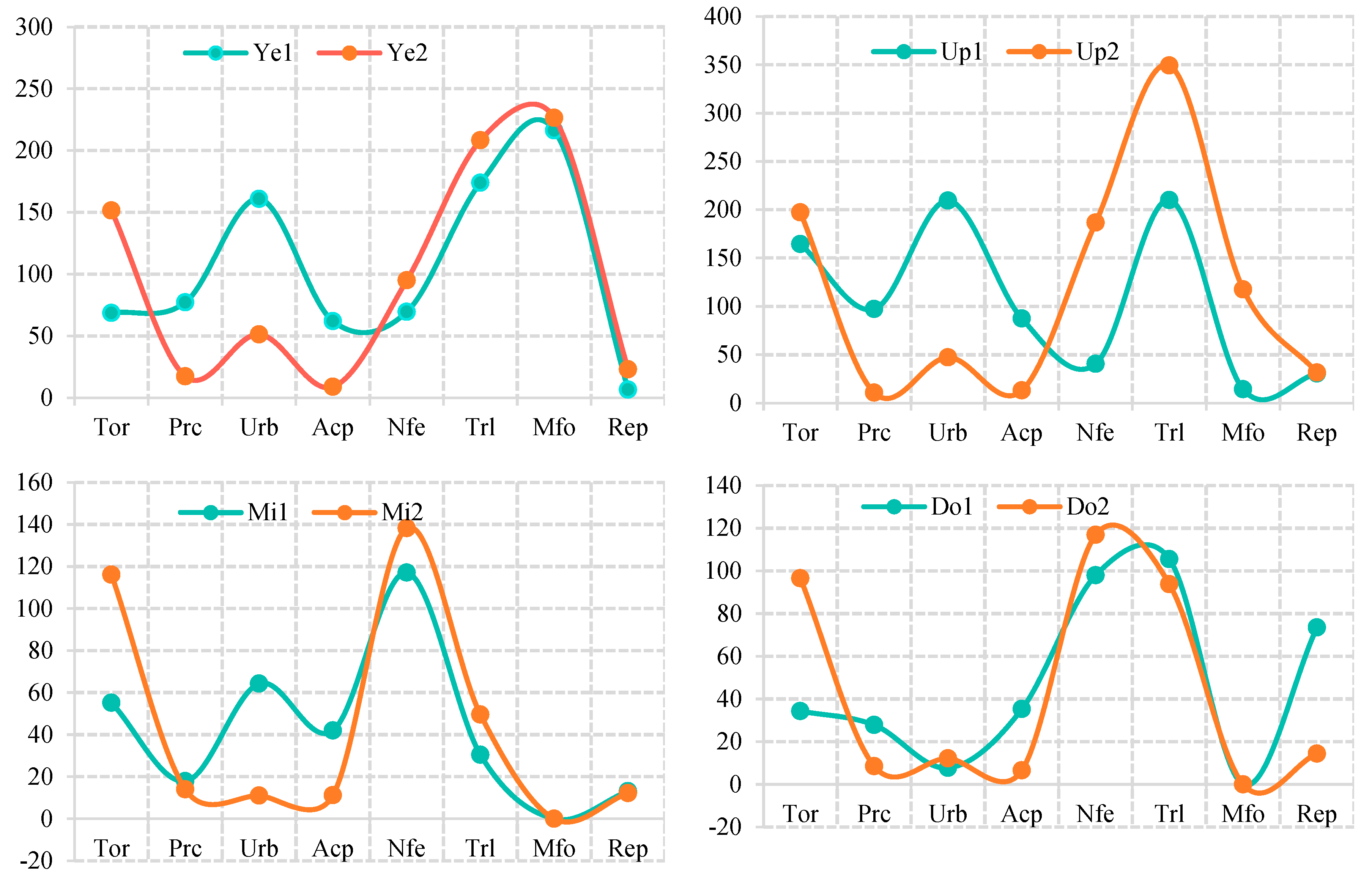
4.3. Influencing Factors of Spatio-Temporal Differences in Geographical Types of Rural Hollowing-Out in the YRB
5. Discussion
5.1. Evolution of Rural Hollowing-Out Types and Transformation Characteristics
5.2. Assessing the Feature Importance of the Model at Different Spatio-Temporal Scales
5.3. Shortcomings and Future Research
6. Conclusions
Author Contributions
Funding
Institutional Review Board Statement
Data Availability Statement
Conflicts of Interest
References
- Liu, Y.S.; Liu, Y.; Zhai, R.X. Geographical research and optimizing practice of rural hollowing-out in China. Acta Geogr. Sin. 2009, 64, 1193–1202. [Google Scholar]
- Chen, Y.F.; Sun, H.; Liu, Y.S. Reconstruction models of hollowed villages in key agricultural regions of China. Acta Geogr. Sin. 2010, 65, 727–735. [Google Scholar]
- Sun, J.W.; Liu, Y.S.; Ge, D.Z. Coordinated mechanism between comprehensive land consolidation and rural transformation development in plain agricultural areas of China. Acta Geogr. Sin. 2022, 77, 1971–1986. [Google Scholar]
- Liu, Y.; Zhou, Y.; Li, Y. Rural regional system and rural revitalization strategy in China. Acta Geogr. Sin. 2019, 74, 2511–2528. [Google Scholar]
- Li, Y.; Westlund, H.; Liu, Y. Why some rural areas decline while some others not: An overview of rural evolution in the world. J. Rural Stud. 2019, 68, 135–143. [Google Scholar] [CrossRef]
- Gao, X.; Xu, A.; Liu, L.; Deng, O.; Zeng, M.; Ling, J.; Wei, Y. Understanding rural housing abandonment in China’s rapid urbanization. Habitat Int. 2017, 67, 13–21. [Google Scholar] [CrossRef]
- Amartuvshin, A.; Chen, J.; John, R.; Zhang, Y.; Lkhagvaa, D. How does mining policy affect rural migration of Mongolia? Land Use Policy 2021, 107, 105474. [Google Scholar] [CrossRef]
- Li, Y.; Westlund, H.; Zheng, X.; Liu, Y. Bottom-up initiatives and revival in the face of rural decline: Case studies from China and Sweden. J. Rural Stud. 2016, 47, 506–513. [Google Scholar] [CrossRef]
- Zhou, Z. The hollowing out of China’s rural population and its challenges. Popul. Res. 2008, 32, 45–52. [Google Scholar]
- Wang, L.; Chen, K.; Li, N. The degree measure and spatial-temporal variation characteristics of rural population hollowing on county-level in China. Popul. J. 2017, 39, 14–24. [Google Scholar]
- Yu, L.J.; Sun, D.S.; Zhang, D.X.; Zheng, B.; Han, L.; Yu, Z. Rural household survey based analysis of hollowing of rural residential land in China. Sci. Geogr. Sin. 2016, 36, 1043–1049. [Google Scholar]
- Wang, L.; Wu, J. Study on the influencing factors of homestead hollowing in a household’s perspective. Geogr. Res. 2019, 38, 2201–2211. [Google Scholar]
- Qu, Y.B.; Zhao, L.J.; Chai, Y.F.; Li, Y.F.; Zhu, W.Y.; Ping, Z.L. Multidimensional form identification and targeted governance of hollow villages from the rural revitalization perspective: Taking Fangsi Town of Yucheng City in Shangdong Province as an example. Resour. Sci. 2021, 43, 776–789. [Google Scholar]
- Yang, R.; Liu, Y.S.; Chen, Y.F. Comprehensive measure and partition of rural hollowing-out in China. Geogr. Res. 2012, 31, 1697–1706. [Google Scholar]
- Song, W.; Chen, B.M.; Zhang, Y. Typical survey and analysis on influencing factors of village-hollowing of rural housing land in China. Geogr. Res. 2013, 32, 20–28. [Google Scholar]
- Li, T.; Long, H.; Wang, Y. Analysis of idleness of rural residential land and its causes in China. China Land Sci. 2019, 33, 64–71. [Google Scholar]
- Liu, S.; Xiao, W.; Ye, Y.; He, T.; Luo, H. Rural residential land expansion and its impacts on cultivated land in China between 1990 and 2020. Land Use Policy 2023, 132, 106816. [Google Scholar] [CrossRef]
- Zheng, D.; Wen, Q.; Wang, Y.; Mi, H. Differentiation mechanism and reconstruction strategy of rural population hollowing in China. Econ. Geogr. 2019, 39, 161–168. [Google Scholar]
- Li, Y.; Wang, H. Spatial distribution of rural population flow at the village level in China: Evidence from village samples in the third national agricultural census. Chin. Rural Econ. 2020, 4, 124–144. [Google Scholar]
- Qiao, J.; Liu, J.; Xie, M. Characteristics and Microcosmic Mechanism of Rural Hollow Villages in Less Developed Rural Area: A Case Study of Three Villages in Lankao County. Hum. Geogr. 2011, 26, 98–102. [Google Scholar]
- Wang, C.; Yao, S.; Chen, C. Empirical Study on Village-Hollowing in China. Sci. Geogr. Sin. 2005, 25, 3257–3262. [Google Scholar]
- Liu, Y. Geography of New Countryside Construction of China; Science Press: Beijing, China, 2011. [Google Scholar]
- Liu, Y.S.; Yan, B.; Wang, Y.F. Urban-rural development problems and transformation countermeasures in the new period in China. Econ. Geogr. 2016, 36, 1–8. [Google Scholar]
- Li, Y.R.; Liu, Y.S.; Long, H.L. Spatio-temporal analysis of population and residential land change in rural China. J. Nat. Resour. 2010, 25, 1629–1638. [Google Scholar]
- Tan, X.L.; Yu, S.Y.; Ouyang, Q.L.; Mao, K.B.; He, Y.H.; Zhou, G.H. Assessment and influencing factors of rural hollowing-out in the rapid urbanization region: A case study of Changsha-Zhuzhou-Xiangtan urban agglomeration. Geogr. Res. 2017, 36, 684–694. [Google Scholar]
- Sun, H.; Liu, Y.; Xu, K. Hollow villages and rural restructuring in major rural regions of China: A case study of Yucheng City, Shandong Province. Chin. Geogr. Sci. 2011, 21, 354–363. [Google Scholar] [CrossRef]
- Wen, Q.; Li, J.; Ding, J.; Wang, J. Evolutionary process and mechanism of population hollowing out in rural villages in the farming-pastoral ecotone of Northern China: A case study of Yanchi County, Ningxia. Land Use Policy 2023, 125, 106506. [Google Scholar] [CrossRef]
- Luo, X.; Tong, Z.; Liu, Y.; Xiong, Q.; Wu, Z.; Chen, H. Revealing the formation mechanism of rural housing hollowing via considering the nonlinear effects of spatial factors and planning variables. Appl. Geogr. 2023, 155, 102957. [Google Scholar] [CrossRef]
- Wang, F.; Ma, Y.L.; Qiao, J.J. Scale effect of center city impact on geographic distribution pattern of rural hollowing-out: A case study of Henan province. Areal Res. Dev. 2018, 37, 132–137. [Google Scholar]
- Yuan, Y.; Shi, X.; Niu, S.; Zhang, C.; Yan, S. A GWR-based study on Jincheng city hollow village driving force. Econ. Geogr. 2015, 35, 148–155. [Google Scholar]
- Chen, K.; Wang, L.; Li, N. Rural hollowing-out out in counties of China: Connotation, distribution and formation mechanism. Popul. Econ. 2018, 1, 28–37. [Google Scholar]
- Leadership Office of the Fifth National Population Census of the State Council. China’s Population Census Data by County-2000; Statistics Press: Beijing, China, 2002. [Google Scholar]
- Leadership Office of the Sixth National Population Census of the State Council. China’s Population Census Data by County-2010; Statistics Press: Beijing, China, 2012. [Google Scholar]
- Leadership Office of the Seventh National Population Census of the State Council. China’s Population Census Data by County-2020; Statistics Press: Beijing, China, 2022. [Google Scholar]
- Miao, C.; Zhang, B. Regulation strategy of Zoning-Gradation-Classification for high-quality development in the Yellow River Basin. Econ. Geogr. 2021, 41, 143–153. [Google Scholar]
- Long, H. Land use transition and land management. Geogr. Res. 2015, 34, 1607–1618. [Google Scholar]
- Long, H.; Chen, K. Urban-rural integrated development and land use transitions: A perspective of land system science. Acta Geogr. Sin. 2021, 76, 295. [Google Scholar]
- Zheng, D.Y.; Wen, Q.; Wang, X.J. Spatial differentiation and influencing factors of coupled development of rural poverty and hollowing. Hum. Geogr. 2020, 35, 74–80. [Google Scholar]
- Liu, Y. Research on the urban-rural integration and rural revitalization in the new era in China. Acta Geogr. Sin. 2018, 73, 637–650. [Google Scholar]
- Ge, D. The characteristics and multi-scale governance of rural space in the new era in China. Acta Geogr. Sin. 2023, 78, 1849–1868. [Google Scholar]
- Chen, T.; Guestrin, C. Xgboost: A scalable tree boosting system. In Proceedings of the 22nd ACM Sigkdd International Conference on Knowledge Discovery and Data Mining, San Francisco, CA, USA, 13–17 August 2016; pp. 785–794. [Google Scholar]
- Lundberg, S.M.; Lee, S.I. A unified approach to interpreting model predictions. Adv. Neural Inf. Process. Syst. 2017, 30. [Google Scholar] [CrossRef]
- Rui, C.; Bin, L.; Min, L.; Ruina, S. Predicting prices and analyzing features of online short-term rentals based on XGBoost. Data Anal. Knowl. Discov. 2021, 5, 51–65. [Google Scholar]


| Rural Population Change Rate | Change Rate of Rural Residential Areas | Geographical Types |
|---|---|---|
| >0 | 0~50% | Smart development type (SDT) |
| <0 | <0 | |
| −30%~0 | <100% | Human–land recession type (HRT) |
| −30%~0 | 50~100% | |
| −15%~0 or <−30% | >100% | Land expansion type (LET) |
| <−30% | 0~50% | Population loss type (PLT) |
| −30~−15% | >100% | Human–land–vacant waste type (HLW) |
| <−30% | >50% |
| Variable | Indicator | Meaning of Indicator | Data Sources |
|---|---|---|---|
| Dependent variable | Rural hollow area type (Rht) | SDT:1, MLR:2, LET:3, PLT:4, HLW:5 | — |
| Geographical environment | Topographic relief (Tor) | Topographic relief | 30 m resolution DEM data |
| Precipitation variation (Prc) | Change in average annual precipitation | http://data.cma.cn/ | |
| Socioeconomic | Urbanization (Urb) | Urban population/total population | Chinese census data |
| Changes in agricultural productivity (Acp) | The difference in agricultural value added/rural population between different years | Provincial statistical yearbooks | |
| Economic non-agriculturalization (Nfe) | The difference in non-farm GDP per capita between different years | Provincial statistical yearbooks | |
| Location and planning | Location (Trl) | Distance from provincial capitals | Euclidean distance |
| Main function types (Mfo) | Main agricultural product producing areas = 1, urbanized area = 2, key ecological function area = 3 | Provincial main functional area planning | |
| Regional planning (Rep) | Whether it belongs to urban agglomeration or not: yes: 1, no: 2 | Miao, C., Zhang, B. [35] (Miao and Zhang, 2021). |
Disclaimer/Publisher’s Note: The statements, opinions and data contained in all publications are solely those of the individual author(s) and contributor(s) and not of MDPI and/or the editor(s). MDPI and/or the editor(s) disclaim responsibility for any injury to people or property resulting from any ideas, methods, instructions or products referred to in the content. |
© 2024 by the authors. Licensee MDPI, Basel, Switzerland. This article is an open access article distributed under the terms and conditions of the Creative Commons Attribution (CC BY) license (https://creativecommons.org/licenses/by/4.0/).
Share and Cite
Fu, Z.; Yang, Y.; Wang, L.; Zhu, X.; Lv, H.; Qiao, J. Geographical Types and Driving Mechanisms of Rural Hollowing-Out in the Yellow River Basin. Agriculture 2024, 14, 365. https://doi.org/10.3390/agriculture14030365
Fu Z, Yang Y, Wang L, Zhu X, Lv H, Qiao J. Geographical Types and Driving Mechanisms of Rural Hollowing-Out in the Yellow River Basin. Agriculture. 2024; 14(3):365. https://doi.org/10.3390/agriculture14030365
Chicago/Turabian StyleFu, Zhanhui, Yahan Yang, Lijun Wang, Xiaoyong Zhu, Hui Lv, and Jiajun Qiao. 2024. "Geographical Types and Driving Mechanisms of Rural Hollowing-Out in the Yellow River Basin" Agriculture 14, no. 3: 365. https://doi.org/10.3390/agriculture14030365