Abstract
This review focuses on digital soil organic carbon (SOC) mapping at regional or national scales in spatial resolutions up to 1 km using open data remote sensing sources, emphasizing its importance in achieving United Nations’ Sustainable Development Goals (SDGs) related to hunger, climate action, and land conservation. The literature review was performed according to scientific studies indexed in the Web of Science Core Collection database since 2000. The analysis reveals a steady rise in total digital soil mapping studies since 2000, with digital SOC mapping studies accounting for over 20% of these studies in 2023, among which SDGs 2 (Zero Hunger) and 13 (Climate Action) were the most represented. Notably, countries like the United States, China, Germany, and Iran lead in digital SOC mapping research. The shift towards machine and deep learning methods in digital SOC mapping has surged post-2010, necessitating environmental covariates like topography, climate, and spectral data, which are cornerstones of machine and deep learning prediction methods. It was noted that the available climate data primarily restrict the spatial resolution of digital SOC mapping to 1 km, which typically requires downscaling to harmonize with topography (up to 30 m) and multispectral data (up to 10–30 m). Future directions include the integration of diverse remote sensing data sources, the development of advanced algorithms leveraging machine learning, and the utilization of high-resolution remote sensing for more precise SOC mapping.
1. Introduction
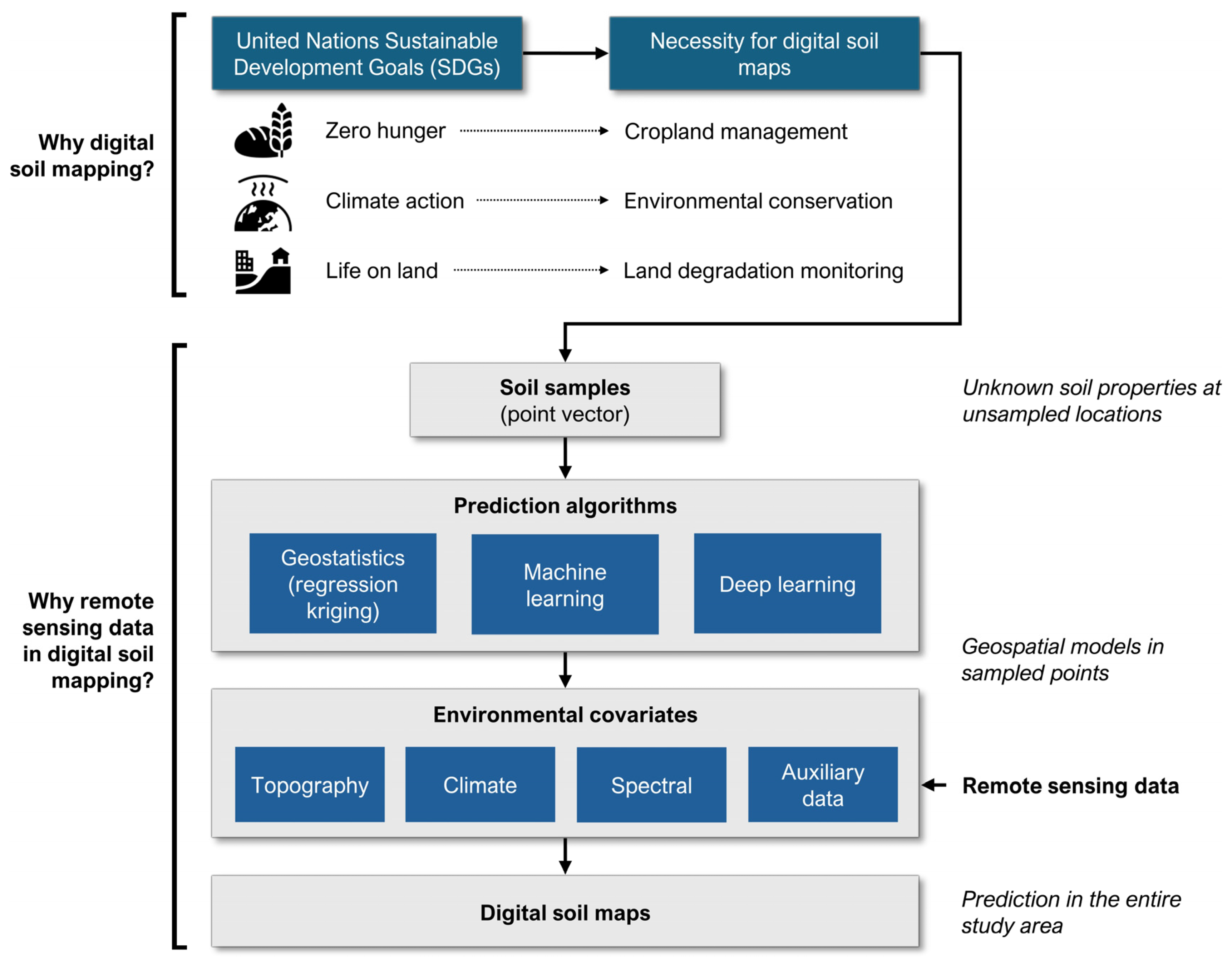
Soil organic carbon (SOC) is a key component of soil health and is essential for plant growth, water retention, and nutrient cycling [1]. However, SOC is challenging to measure directly, and traditional methods of SOC mapping are often time-consuming and expensive [2]. Digital soil mapping offers a potential solution to these challenges by using remote sensing data to estimate SOC at regional or national scales [3]. The development of digital soil mapping has been driven by advances in remote sensing technology [4]. The affordability and accessibility of satellite imagery have increased in recent decades [5], and it can provide valuable information on environmental conditions that affect SOC levels. Digital SOC mapping directly contributes to the United Nations Sustainable Development Goals (SDGs), especially Goals 2 (Zero Hunger), 13 (Climate Action), and 15 (Life on Land) [6]. The necessity for digital SOC maps to meet these SGDs is evident in their significant potential to enhance cropland management, environmental conservation, and land degradation monitoring (Figure 1). These maps provide a basis for soil management practices in terms of cropland management, such as crop rotation planning, irrigation, and fertilization, which can lead to increased crop yields and soil health [7]. Moreover, digital SOC maps facilitate environmental conservation by identifying and monitoring areas with high carbon sequestration potential, thereby contributing to climate change mitigation efforts [8]. These maps also serve for land degradation monitoring, providing insights into changes in soil carbon stocks and soil health over time [9].
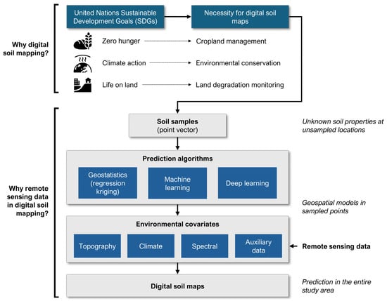
Figure 1.
The role of digital soil mapping and remote sensing data in achieving SDGs.
Digital soil mapping is a process that involves the creation of spatial soil property predictions using various data sources and statistical or machine learning methods [10]. The process typically begins with the collection of point vector soil samples, which are then used to create spatial soil property predictions for unknown locations [11]. This is typically achieved by predicting soil property values from the sample points to unsampled locations based on environmental covariates, such as topography, spectral, and climate data [12,13]. Regression kriging, machine learning, and deep learning are the predominant methods used to predict soil properties by establishing statistical models that learn the relationship between environmental covariates and ground truth soil samples [14]. Among the classical geostatistical methods, regression kriging combines traditional regression techniques with kriging to improve the accuracy of spatial predictions of soil properties [15]. The process involves the use of regression to model the relationship between soil properties and environmental covariates at sample points, followed by the use of the spatial autocorrelation information captured by kriging to make predictions at unsampled locations [16,17]. Machine learning algorithms in the field of digital soil mapping, such as random forests, support vector machines, or neural networks, are employed to learn complex relationships between soil properties and covariates from data [18]. These models can capture nonlinear relationships and interactions between variables, thereby improving prediction accuracy over traditional methods. This approach is further enhanced by deep learning, a subset of machine learning, which employs neural networks with multiple layers to extract intricate patterns and relationships from data [19]. Deep learning can be utilized to process large volumes of data and identify complex spatial patterns in digital soil mapping, frequently resulting in more precise soil property predictions when compared to regular machine learning methods [14,20].
The utilization of global, openly accessible remote sensing data in digital soil mapping provides a means of accessing a vast array of geospatial information without the necessity for costly data acquisition or extensive fieldwork. This accessibility enables the development of more accurate soil property predictions by incorporating diverse environmental variables derived from remote sensing sources, enhancing the overall quality and reliability of the mapping results [21]. Globally available soil maps, such as SoilGrids [12,13], provide valuable information on soil properties at a high spatial resolution globally. However, these maps have limitations when applied to national or regional scales in terms of potential inaccuracies due to variation in soil data quality or availability across regions, limited detail in representing local soil variability, and uncertainty in extrapolating global models to smaller scales where local factors play a significant role [22]. Additionally, discrepancies may arise from differences in mapping methods, soil classification systems, and ground validation data availability, highlighting the need for creating custom digital SOC maps at specific national or regional levels.
Therefore, the objective of this review is to provide a comprehensive evaluation of the state-of-the-art remote sensing data sources and their applications in digital SOC mapping studies at regional or national scales. While there are several reviews based on digital SOC mapping, this review aimed to provide more thorough information with a focus on (1) meeting SDGs of the United Nations, and consequentially a higher focus on digital SOC mapping studies at regional or national scales in comparison to field-scale studies, which are key for land macro-management; (2) digital SOC mapping studies based on state-of-the-art machine and deep learning methods; and (3) open-source environmental covariates with spatial resolutions up to 1 km and specific challenges in their use in digital SOC mapping. A particular focus was placed on remote sensing data utilized in the modeling of three primary environmental covariate groups, including topography, climate, and spectral data with up to 1 km spatial resolution, meeting the requirements for most digital SOC mapping studies on national and regional scales.
2. Digital SOC Mapping Studies Indexed in Web of Science Core Collection (WoSCC)
2.1. State of the Digital SOC Mapping Studies since 2000 on a Global Level
Since 2000, digital SOC mapping has made significant progress due to technological progress and enhanced methodologies. Initiatives such as GlobalSoilMap [23] and GSOCmap [24] have had a crucial role in the creation of high-resolution global SOC maps, utilizing advanced technologies and diverse data sources to improve the accuracy and accessibility of soil data. The integration of machine learning models such as Random Forest (RF) and Support Vector Machines (SVMs) together with remote sensing data has significantly improved the accuracy of SOC prediction and mapping. The importance of remote sensing for digital soil and SOC mapping and prediction is clearly illustrated by the increasing number of WoSCC studies since 2000, as shown in Figure 2.
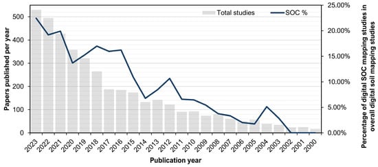
Figure 2.
The number of papers indexed in WoSCC according to topics of “remote sensing” AND (“digital soil mapping” OR “soil prediction”) for total digital soil mapping studies and “remote sensing” AND (“digital soil mapping” OR “soil prediction”) AND “soil organic carbon” for digital SOC mapping studies.
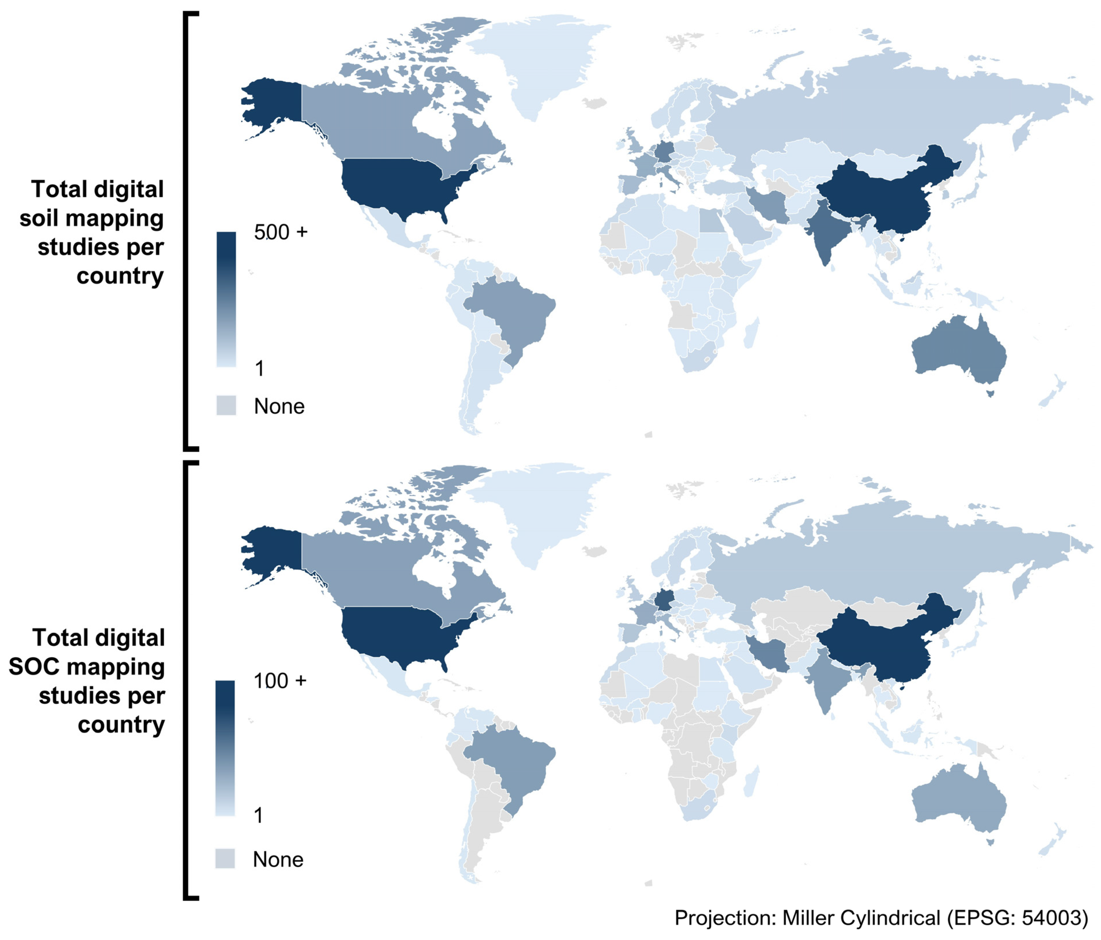
Studies in regions such as the upper Brahmaputra valley [25] in India, across Latin America [26], Africa [27], and Europe [14] have shown the effectiveness of these techniques in different environmental conditions and soil types. Regional and national studies have underscored the variability and complexity of SOC, revealed significant spatial discrepancies, and emphasized the need for localized approaches to improve accuracy and reduce uncertainty. Digital soil mapping studies on national and regional scales are crucial for understanding soil spatial variability, managing soil resources, and addressing global environmental challenges on a macro-scale. Despite omitting information on local and site-specific scales, these maps provided vital information for sustainable agriculture, ecosystem conservation, and climate change mitigation. For instance, national-scale digital soil mapping initiatives, such as the African Soil Information Service [28] and the United States Department of Agriculture (USDA) Soil Survey Geographic database [29], have improved soil fertility management, reduced chemical fertilizer applications, and enhanced carbon sequestration [30]. Figure 3 shows the distribution of papers indexed in WoSCC per country related to digital soils and SOC mapping and prediction by remote sensing methods and techniques.
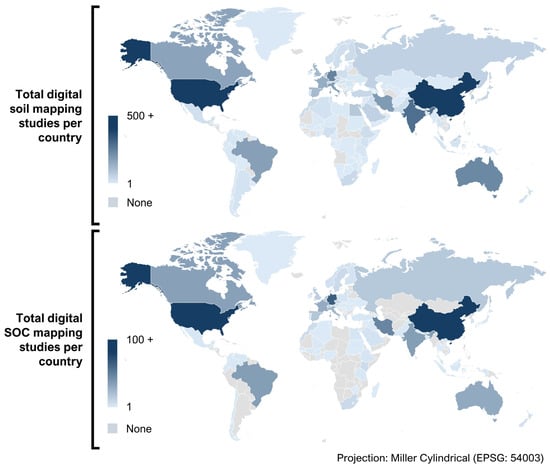
Figure 3.
The world map representing the number of papers indexed in WoSCC per country according to topics of “remote sensing” AND (“digital soil mapping” OR “soil prediction”) for total digital soil mapping studies and “remote sensing” AND (“digital soil mapping” OR “soil prediction”) AND “soil organic carbon” for digital SOC mapping studies.
2.2. United Nations’ SDGs Addressed in Digital SOC Mapping Studies
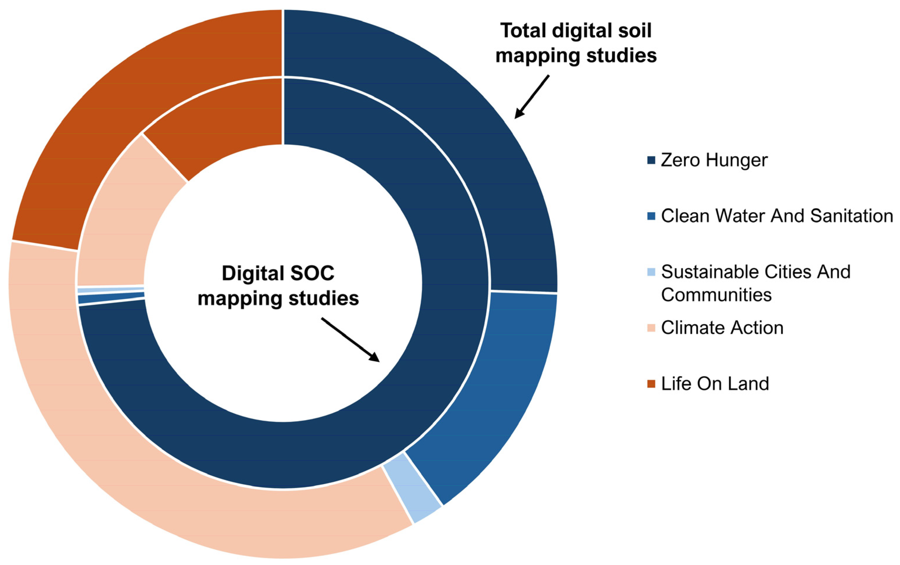
Remote sensing techniques and methods for soil and SOC mapping and prediction are crucial in achieving several SDGs [31], in particular, Zero Hunger (SDG 2), Clean Water and Sanitation (SDG 6), Sustainable Cities and Communities (SDG 11), Climate Action (SDG 13), and Life on Land (SDG 15). Figure 4 shows the distribution of papers indexed in WoSCC related to digital soils and SOC mapping and prediction by remote sensing methods and techniques across the above five SDGs. The global progress towards SDGs 2 and 13, as the most frequently represented goals in digital soil mapping and digital SOC mapping studies, is mixed. SDG 2 aims to end hunger, achieve food security, improve nutrition, and promote sustainable agriculture, while SDG 13 addresses climate action, specifically targeting strengthening resilience and adaptive capacity to climate-related hazards and extreme weather events. According to the Food and Agriculture Organization (FAO), despite some progress, the world is not on track to achieve Zero Hunger by 2030, with the prevalence of undernourishment stagnating since 2015 [32]. In combination with the total amount of digital SOC mapping studies data, the lowest number of digital SOC mapping studies was observed in Africa, which should be encouraged in the future. This would support the achievement of SDGs in the entire world, primarily referring to SDG 2, as presently there is a large disparity in the digital SOC mapping research globally.

Figure 4.
The SDGs of papers indexed in WoSCC according to topics of “remote sensing” AND (“digital soil mapping” OR “soil prediction”) for total digital soil mapping studies and “remote sensing” AND (“digital soil mapping” OR “soil prediction”) AND “soil organic carbon” for digital SOC mapping studies.
Previous studies strongly suggested that digital SOC mapping supports the SDGs by increasing prediction accuracy, using open data sources, and focusing on key soil properties to understand SOC distribution [33,34]. Precision agriculture and monitoring soil health through remote sensing optimize resource use and increase crop yields to combat hunger. By mapping SOC and monitoring greenhouse gas emissions, remote sensing contributes to climate change mitigation by supporting carbon sequestration and climate resilience strategies [35]. Techniques such as high-resolution satellite imagery, LiDAR, spectroscopy, UAVs, and geostatistical methods provide important data for these purposes and enable sustainable agricultural practices, climate change mitigation, and conservation of terrestrial ecosystems, driving progress towards a sustainable and resilient future [36].
2.3. Prediction Approaches and the Role of Remote Sensing Data in Digital SOC Mapping Studies
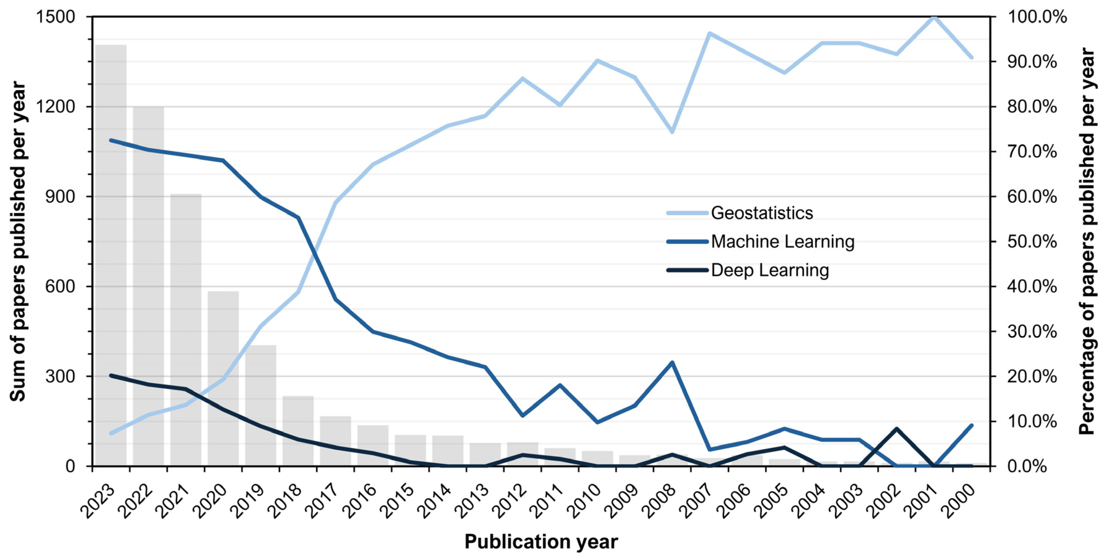
Technological advances in GIS, remote sensing, and big data analytics have been crucial in refining digital SOC maps by integrating various environmental covariates such as topography, vegetation indices, and climatic factors [37]. Despite these advances, it remains a challenge to produce consistent and accurate global SOC maps, especially due to the heterogeneity of soil data and the need to harmonize methods across different regions [38]. Future efforts will likely focus on improving data integration, improving modeling algorithms, and increasing the resolution and accuracy of SOC maps to provide better information for soil management and climate change mitigation strategies. In more than the last two decades, a lot of novel algorithms and techniques based on machine learning and deep learning have been used to improve digital soil and SOC mapping and prediction [39,40] instead of traditional geostatistical approaches. Figure 5 shows the number of papers indexed in WoSCC on remote sensing topics in the field of soil and SOC mapping and prediction using different prediction approaches, e.g., machine learning, deep learning, and geostatistics. New algorithms based on machine and deep learning approaches have almost completely replaced traditional geostatistical approaches in recent years due to increased prediction accuracy, computational efficiency, and reduced errors compared to traditional methods [41].
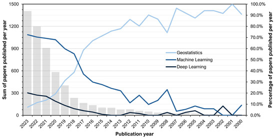
Figure 5.
The number of papers indexed in WoSCC according to topics of “remote sensing” AND (“digital soil mapping” OR “soil prediction”) AND: “geostatistics”; “machine learning”; and 3) “deep learning” for each of the major method principles in digital soil mapping. The gray bars indicate a sum of papers published per year.
3. Environmental Covariates from Remote Sensing Data Sources in State-of-the-Art Digital SOC Mapping Studies Indexed in WoSCC
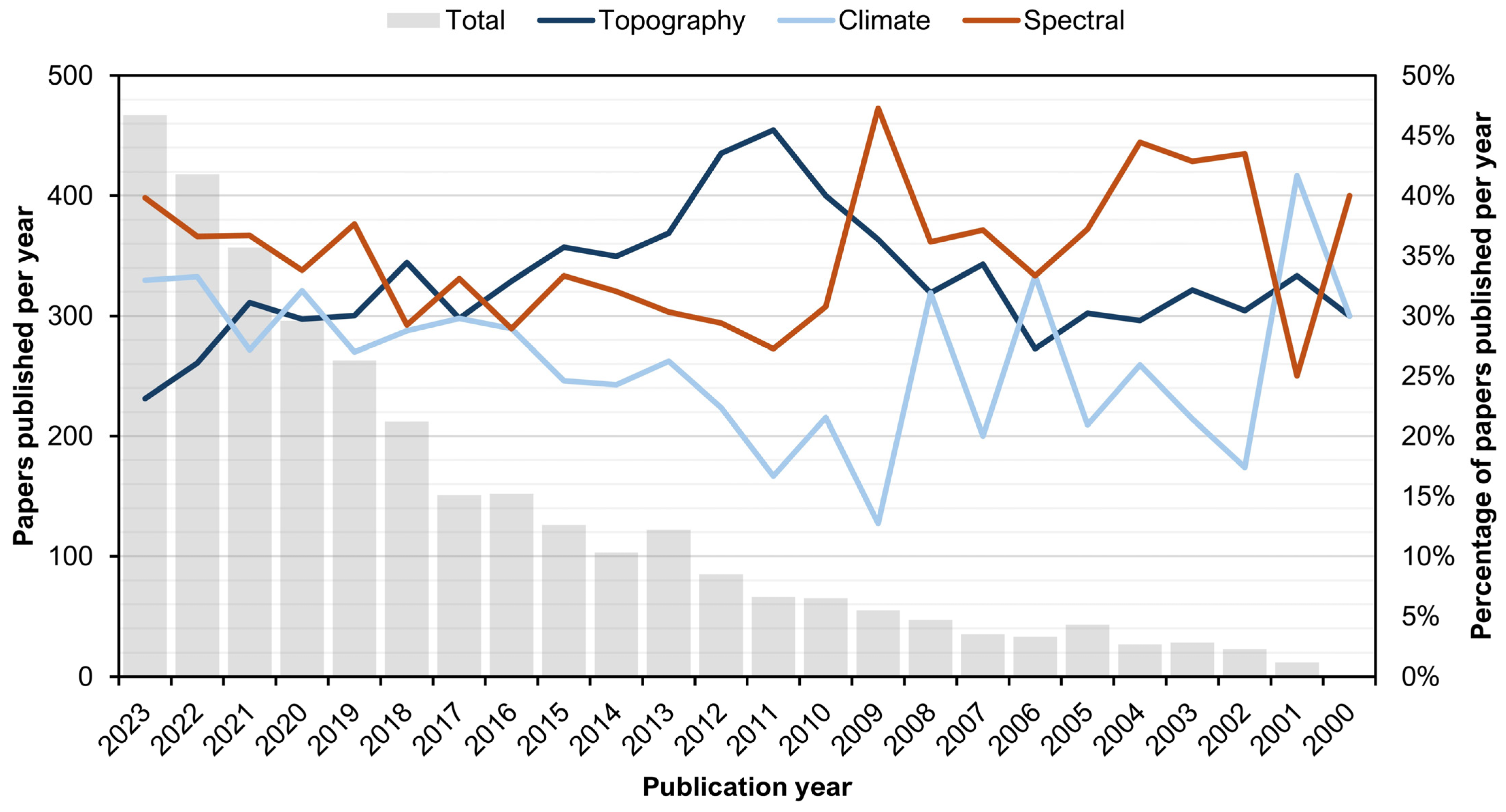
Three primary environmental covariate groups were commonly used for digital SOC mapping (Figure 6), topography, climate, and spectral, along with other data sources. The analyzed remote sensing data used for these covariates include only open data sources in this review, which promotes reproducibility in SOC mapping efforts on a global scale [42]. This approach offers several advantages, including the ability to capture detailed information on soil properties at a high spatial resolution, monitor changes in SOC levels over time, and support sustainable land management practices [43].
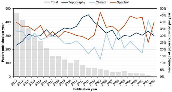
Figure 6.
The number of papers indexed in WoSCC according to topics of “remote sensing” AND (“digital soil mapping” OR “soil prediction”) AND: “topography OR elevation”; “climate”; “spectral” OR “multispectral” for each of the primary covariate groups in digital soil mapping.
Topography from digital elevation model (DEM) data provides information on the landscape’s physical characteristics such as slope, aspect, and elevation. These factors influence soil formation processes, vegetation distribution, and soil moisture content, which in turn affect the accumulation and decomposition rates of organic carbon in soils [44,45]. High-resolution DEMs can help identify areas with high organic carbon storage potential, such as flat terrains with good water retention capacity. These topographic features aid in predicting soil erosion, water flow patterns, and nutrient cycling, all of which influence the distribution and dynamics of SOC [46]. Climate variables enable the estimation of the distribution and dynamics of SOC in soil formation and decomposition processes [47]. Increased temperature typically accelerates decomposition processes, leading to higher SOC turnover rates and potentially lower SOC stocks [48]. Precipitation, on the other hand, affects soil moisture, which can influence both soil biota activity and the stability of SOC [49]. The use of multispectral remote sensing in SOC mapping allows for the assessment of SOC over large areas quickly and inexpensively, without the need for labor-intensive and time-consuming field measurements [5]. These data help in delineating different land cover types, including vegetation, which is crucial for assessing SOC content due to the strong relationship between vegetation cover and carbon sequestration [50]. The information extracted from multispectral satellite imagery aids in mapping vegetation health and biomass based on spectral indices [51], which are all important factors influencing SOC dynamics.
Table 1 provides a summary of recent scientific papers focused on digital SOC mapping using machine and deep learning techniques along with environmental covariates derived from remote sensing data, primarily for various national- or regional-scale studies. While this is not a complete list of digital SOC mapping studies indexed in WoSCC on regional or national scales, it focused on assessing three dominant environmental covariate groups in machine and deep learning studies, clearly proving the focus on topography, climate, and spectral covariates. The number of environmental covariates utilized in each study varies, with the most frequently employed environmental covariates being topography and spectral data. This is due to the specificity of digital SOC mapping studies on regional and national scales, which, unlike site-specific studies, put much more emphasis on climate covariates due to their increased variability with the study area size. Moreover, these covariates frequently restrict the spatial resolution of digital SOC mapping studies due to the same reason. The area covered in each study also varies considerably, with the smallest area being 6.8 km2 in Iran and the largest area being 9,834,000 km2 in the USA, encompassing a wide range of spatial scales, while a primary focus was put on studies on regional and national scales.

Table 1.
A list of recent (2018–) representative digital SOC mapping papers based on machine and deep learning and environmental covariates from remote sensing data sources.
3.1. Topography Covariates
Topography covariates commonly include attributes such as slope, aspect, curvature, elevation, and landform classifications [89]. The slope represents the gradient of the land surface, which affects water flow, erosion, and soil development rates, thereby influencing SOC stocks [90]. By indicating the direction that a slope faces, aspects quantify the impacts of solar radiation, temperature, and moisture availability, all of which also affect SOC dynamics [91]. Additionally, elevation provides information about the altitude and climate patterns of the area, which affect soil-forming factors such as temperature, precipitation, vegetation, and ultimately SOC sequestration [92]. Landform classifications are also essential for digital SOC mapping as they provide a higher-level understanding of the terrain features and their spatial distribution, allowing for more accurate modeling and mapping of SOC stocks [93]. Additionally, hydrological variables can be derived from DEM data using methods such as flow accumulation, flow direction, stream network delineation, watershed delineation, and computation of hydrological metrics like drainage density, stream order, and watershed characteristics.
The ASTER GDEM (Advanced Spaceborne Thermal Emission and Reflection Radiometer Global Digital Elevation Model) and SRTM (Shuttle Radar Topography Mission) are currently among the most used DEMs due to their long presence in global DEM availability (Table 2). GTOPO30 is another widely utilized DEM dataset offering a 30 arc-second resolution for topographic analysis. However, the Copernicus DEM provides high-resolution elevation data derived from satellite imagery, achieving notably higher vertical accuracy in comparison to ASTER, SRTM, and GTOPO30 DEMs. As their spatial resolution is typically higher than those from other main covariate groups, all these DEMs have the potential for mapping SOC as terrain elevation influences soil properties, vegetation distribution, and overall carbon dynamics in terrestrial ecosystems.
Table 2.
Global open data DEMs that are presently among the most used DEMs for topography covariates for digital SOC mapping.
3.2. Climate Covariates
The use of high-resolution climate data can enhance the prediction of SOC stocks by taking into account local climate patterns and variations that may impact SOC dynamics [98]. Lower-resolution climate data, typically with a resolution of approximately 5 km or lower, may not capture local climate patterns accurately and may not be suitable for precise SOC modeling, particularly in areas with complex terrain [99]. Although lower-resolution data may be useful for analyzing climate trends and variability over larger areas, it may not provide the level of detail required for accurate digital soil mapping. In addition to high spatial resolution, climate data used for digital SOC mapping should also have a high temporal resolution to capture the variability of climate parameters over time, which can significantly affect SOC dynamics [100]. Additionally, the climate data should be relevant to the soil processes being modeled, such as temperature and precipitation data for SOC decomposition and formation. To minimize potential errors or biases in the SOC maps, it is crucial to ensure the consistency and compatibility of the climate data with other input data used in the digital soil mapping process, such as ground truth climate data stations [101]. There are currently two comprehensive global open data climate sources with a 1 km spatial resolution suitable for digital SOC mapping, among other more restricted data, which include CHELSA and WorldClim datasets.
CHELSA provides monthly temperature and precipitation data from between 1979 and 2013 [102]. The dataset is calculated based on a two-step approach where the coarse-scale climate model data are first downscaled using a weather typing algorithm and then further refined using a high-resolution digital elevation model [103]. This method allows CHELSA to capture fine-scale variations in climate patterns, especially in complex terrain. WorldClim contains monthly temperature and precipitation data from 1970 to 2000 [104]. It is calculated using a different approach that involves spatially interpolating data from weather stations using thin-plate splines. Both CHELSA and WorldClim also provide data for future climate scenarios based on climate model projections. Both datasets have been used in numerous studies for SOC mapping and have been shown to be reliable for predicting SOC stocks at regional and global scales [13,105]. However, it is important to consider the limitations of the datasets, such as uncertainties in the input data and assumptions made during data generation, when using them for SOC modeling. CHELSA’s supplementary bioclimatic variables offer more detailed and comprehensive information on monthly climate conditions compared to WorldClim’s standard variables (Table 3). Additionally, CHELSA provides monthly climate variables instead of WorldClim’s annual averages. This allows for a more detailed analysis of seasonal and inter-annual climate variability, which is particularly useful for studying the impacts of climate change on SOC levels, as alterations in monthly climate patterns can have substantial impacts on ecosystems and the species they sustain [106].
Table 3.
Climate variables provided by CHELSA and WorldClim for climate covariates for digital SOC mapping.
3.3. Spectral Covariates
A comparison of different Earth observation satellites used as spectral covariates in digital SOC mapping reveals notable differences in spatial, temporal, and radiometric resolution (Table 4). One of the newest additions, Sentinel-2, provides high spatial resolution (10 to 60 m) with a short revisit time (5 days), facilitating detailed monitoring of the Earth’s surface [107]. Earlier satellites, such as Landsat 5 TM and SPOT [108], provide moderate spatial resolution (30 to 20 m) but with longer revisit times (16 days) and have notably larger historically available data. High spatial resolution satellites, such as the SkySat and Worldview series, are capable of detailed imaging but have smaller swath widths [109], limiting coverage compared to wider swath satellites such as MODIS and Sentinel-2.
Table 4.
Satellite multispectral missions for spectral covariates for digital SOC mapping.
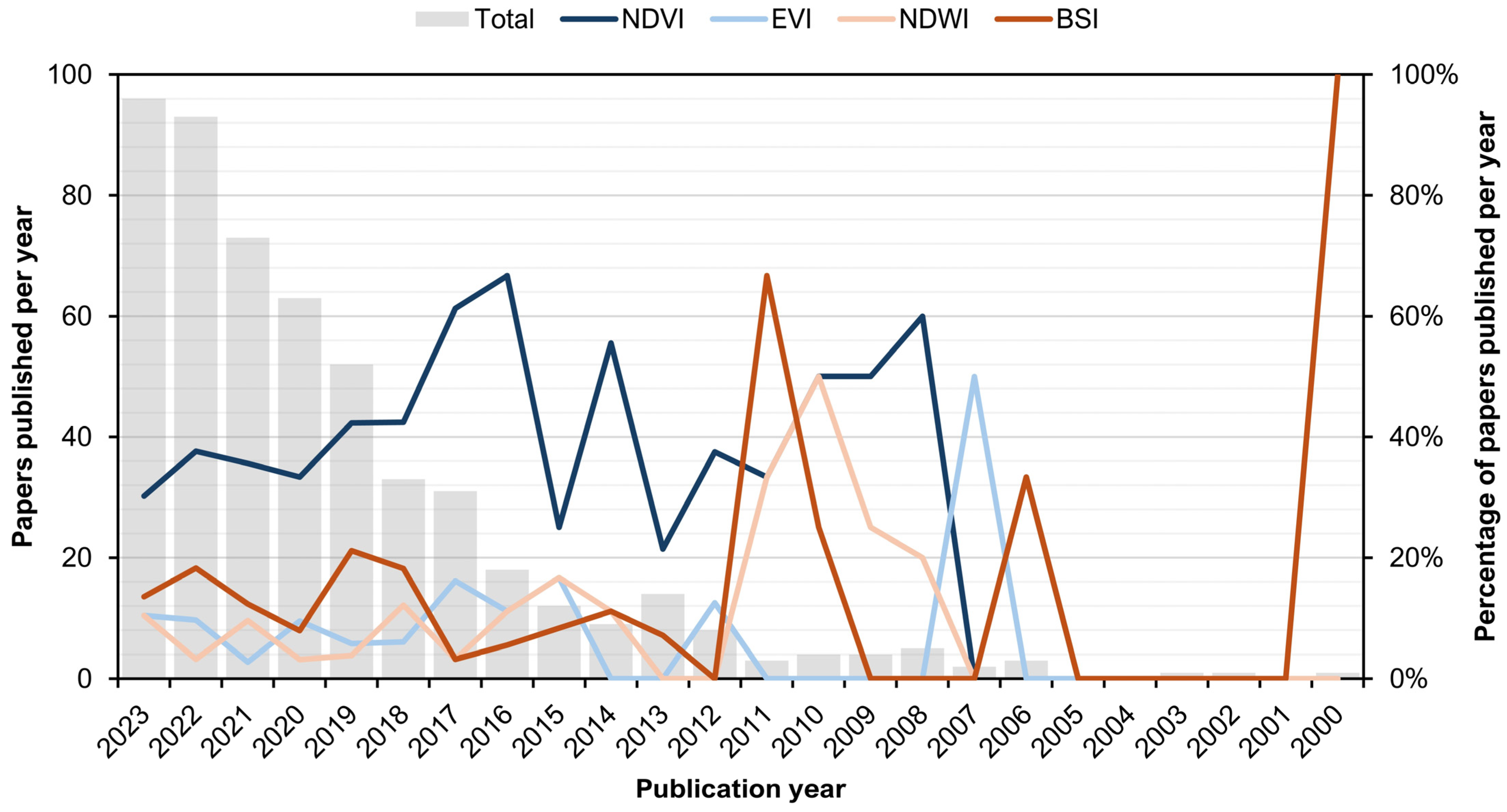
The use of high-spatial-resolution data, as provided by satellite missions such as Worldview, is not always critical due to the limitations of climate data even after downscaling. Instruments such as MODIS with its moderate spatial resolution of 250 m, as well as Sentinel or Landsat with their 10–30 m spatial resolutions, are often sufficient for digital SOC mapping studies [13,110]. Given these limitations, it is important to consider other covariates, especially climate, when selecting a satellite dataset for digital SOC mapping. The use of multispectral data allows for the differentiation of organic carbon-rich soils from those with lower organic carbon content, providing valuable information for soil management and carbon sequestration studies [65]. However, cloud cover can pose a significant challenge to remote sensing applications [111], including SOC mapping. Clouds and their shadows can obstruct the satellite’s view of the Earth’s surface, resulting in data gaps and reduced spatial coverage. Several techniques can be used to address this issue, including cloud masking, time series analysis, and data fusion with other sensors. The ability to capture reflected light in multiple wavelength bands allows for the calculation of spectral indices as mathematical combinations of reflectance values from different bands [51]. These indices can be used to estimate various soil properties, including SOC content. The Normalized Difference Vegetation Index (NDVI) [112] and Enhanced Vegetation Index (EVI) [113] are the most frequently used indices that are sensitive to vegetation cover and canopy structure for digital SOC mapping (Figure 7), along with the Normalized Difference Water Index (NDWI) [114] and Bare Soil Index (BSI) [115] for representing soil moisture and canopy cover, respectively. The popularity of spectral indices as covariates in digital SOC mapping studies has rapidly grown since 2010, with NDVI having a stable representation in at least 20% of these studies.
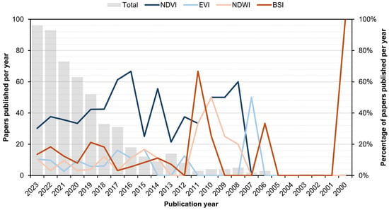
Figure 7.
The number of papers indexed in WoSCC according to topics of “soil organic carbon” AND (“digital soil mapping” OR “soil prediction”) AND “normalized difference vegetation index OR NDVI”; “enhanced vegetation index OR EVI”; “normalized difference water index OR NDWI”; “bare soil index OR BSI” for each of the most frequently used spectral indices in digital SOC mapping.
3.4. Other Notable Environmental Covariate Groups
Besides the main environmental covariate groups for digital SOC mapping, other covariates were used with a lesser frequency in previous studies, especially geology (parent material), land cover, and radar covariates [12,42,116]. For some of these covariates, especially geology data, data availability may be an issue on a global scale, while land cover and radar data importance vary with spatial resolution and study area coverage for digital SOC mapping studies.
The geological composition of an area influences the initial carbon content and distribution in soils through mineral composition, texture, and weathering processes [117]. This information helps to improve the accuracy of digital mapping techniques, allowing for more precise predictions of SOC distribution across different landscapes. However, there are currently limited open data global raster sources for digital SOC mapping that consider the parent material of soils. Most available datasets are limited to specific regions or countries [118]. Land cover classes provide essential information on the type and distribution of major land cover types, such as forests, grasslands, and croplands, as well as land use practices that directly influence SOC content [119]. These influences include the surface conditions that impact organic carbon inputs, decomposition rates, and overall soil carbon levels. Various global data sources available for land cover mapping include the Moderate Resolution Imaging Spectroradiometer (MODIS) land cover data [120], the European Space Agency’s Climate Change Initiative Land Cover dataset [121], and the United States Geological Survey’s Global Land Cover Characterization dataset [122]. Radar satellite images are a complementary addition to multispectral images due to their ability to penetrate cloud cover and provide consistent observations regardless of weather conditions [123]. These images offer detailed information on soil moisture, texture, and organic matter content, which are all correlated with SOC levels [124]. Global data sources for radar satellite imagery include the European Space Agency’s Sentinel-1 mission, the Japanese Aerospace Exploration Agency’s ALOS-2 mission, and the Canadian Space Agency’s RADARSAT-2 mission.
4. Conclusions and Future Directions
Digital SOC mapping studies with spatial resolutions up to 1 km based on open data remote sensing sources were considered in this review, providing a detailed analysis of SOC, primarily at national to regional scales. Overall, the study objectives of the analysis of open remote sensing data for machine and deep learning studies, as well as for meeting SDGs, showed considerable advancement in recent years. Despite this progress, the geographical distribution of digital SOC mapping studies remains uneven, with some regions being overrepresented while others remain largely understudied. This disparity suggests that current digital SOC maps may not effectively support the meeting of SDGs 2 (Zero Hunger) and 13 (Climate Action) for all parts of the world. The main conclusions from this analysis are the following:
- Digital soil mapping is necessary to meet three SDGs, including goals 2 (Zero Hunger), 13 (Climate Action), and 15 (Life on Land), with SOC being a key soil property in managing these goals;
- The number of overall digital soil mapping studies has grown stably since 2000, with digital SOC mapping studies representing more than 20% of total studies in 2023;
- The United States, China, Germany, and Iran are leading countries in digital SOC mapping according to the total number of studies indexed in WoSCC;
- The lowest number of digital SOC mapping studies was observed in Africa, which should be encouraged in the future, as SDGs should be met globally;
- The application of machine and deep learning in digital SOC mapping studies has grown exponentially since 2010, replacing geostatistical digital soil mapping approaches;
- Machine and deep learning prediction consequentially require environmental covariates for digital SOC mapping, which consists of three primary groups, topography, climate, and spectral, along with auxiliary covariates;
- Available climate data primarily restrict the spatial resolution of digital soil mapping to 1 km, which typically requires downscaling to harmonize with topography (up to 30 m) and multispectral data (up to 10–30 m);
- Spectral indices derived from multispectral data were frequently used as covariates in digital SOC mapping, especially vegetation indices NDVI and EVI, as well as water (NDWI) and soil (BSI) indices;
- Auxiliary environmental covariates primarily include geology (parent material), land cover classes, and radar images.
The future directions in remote sensing studies in digital SOC mapping are expected to involve several advancements: (1) the integration of multi-source remote sensing data, such as optical, radar, and LiDAR; (2) the development of new algorithms using machine learning and artificial intelligence to enable more efficient processing and analysis of the large amounts of data generated by remote sensing; and (3) the use of high-resolution remote sensing data for the creation of more detailed and accurate SOC maps at high spatial resolution (about 30 m). Furthermore, incorporating spatiotemporal dynamics in remote sensing studies could result in the development of dynamic SOC maps that can be updated in real time. Other directions include the use of unmanned aerial vehicles for remote sensing, the fusion of remote sensing and proximal sensing, and more widespread use of hyperspectral remote sensing [125]. Additionally, exploring the potential of emerging satellite missions, such as those equipped with novel sensors like the upcoming NASA’s NISAR mission, can further improve modeling SOC dynamics. These advancements are expected to lead to more accurate, detailed, and dynamic SOC maps that can inform conservation and management practices and mitigate climate change.
Author Contributions
Conceptualization, D.R. and M.G.; methodology, D.R.; software, D.R.; validation, D.R. and M.G.; formal analysis, D.R. and M.G.; investigation, D.R.; resources, M.J.; data curation, D.R.; writing—original draft preparation, D.R. and M.G.; writing—review and editing, D.R., M.G. and M.J.; visualization, D.R.; supervision, M.J.; project administration, M.G.; funding acquisition, D.R. All authors have read and agreed to the published version of the manuscript.
Funding
This study was supported by the Croatian Science Foundation for the ALCAR project “Assessment of the Long-term Climatic and Anthropogenic Effects on the Spatio-temporal Vegetated Land Surface Dynamics in Croatia using Earth Observation Data” (Grant No. HRZZ IP-2022-10-5711).
Data Availability Statement
The data presented in this study are available on request from the corresponding author.
Conflicts of Interest
The authors declare no conflicts of interest.
References
- Lal, R. Soil Health and Carbon Management. Food Energy Secur. 2016, 5, 212–222. [Google Scholar] [CrossRef]
- Aldana-Jague, E.; Heckrath, G.; Macdonald, A.; van Wesemael, B.; Van Oost, K. UAS-Based Soil Carbon Mapping Using VIS-NIR (480–1000 Nm) Multi-Spectral Imaging: Potential and Limitations. Geoderma 2016, 275, 55–66. [Google Scholar] [CrossRef]
- Falahatkar, S.; Hosseini, S.M.; Salman Mahiny, A.; Ayoubi, S.; Wang, S. Soil Organic Carbon Stock as Affected by Land Use/Cover Changes in the Humid Region of Northern Iran. J. Mt. Sci. 2014, 11, 507–518. [Google Scholar] [CrossRef]
- Minasny, B.; McBratney, A.B. Digital Soil Mapping: A Brief History and Some Lessons. Geoderma 2016, 264, 301–311. [Google Scholar] [CrossRef]
- Radočaj, D.; Obhođaš, J.; Jurišić, M.; Gašparović, M. Global Open Data Remote Sensing Satellite Missions for Land Monitoring and Conservation: A Review. Land 2020, 9, 402. [Google Scholar] [CrossRef]
- Viana, C.M.; Freire, D.; Abrantes, P.; Rocha, J.; Pereira, P. Agricultural Land Systems Importance for Supporting Food Security and Sustainable Development Goals: A Systematic Review. Sci. Total Environ. 2022, 806, 150718. [Google Scholar] [CrossRef] [PubMed]
- Allam, M.; Radicetti, E.; Quintarelli, V.; Petroselli, V.; Marinari, S.; Mancinelli, R. Influence of Organic and Mineral Fertilizers on Soil Organic Carbon and Crop Productivity under Different Tillage Systems: A Meta-Analysis. Agriculture 2022, 12, 464. [Google Scholar] [CrossRef]
- Zomer, R.J.; Bossio, D.A.; Sommer, R.; Verchot, L.V. Global Sequestration Potential of Increased Organic Carbon in Cropland Soils. Sci. Rep. 2017, 7, 15554. [Google Scholar] [CrossRef] [PubMed]
- Chappell, A.; Webb, N.P.; Leys, J.F.; Waters, C.M.; Orgill, S.; Eyres, M.J. Minimising Soil Organic Carbon Erosion by Wind Is Critical for Land Degradation Neutrality. Environ. Sci. Policy 2019, 93, 43–52. [Google Scholar] [CrossRef]
- Hengl, T.; de Jesus, J.M.; MacMillan, R.A.; Batjes, N.H.; Heuvelink, G.B.M.; Ribeiro, E.; Samuel-Rosa, A.; Kempen, B.; Leenaars, J.G.B.; Walsh, M.G.; et al. SoilGrids1km—Global Soil Information Based on Automated Mapping. PLoS ONE 2014, 9, e105992. [Google Scholar] [CrossRef]
- Batjes, N.H.; Ribeiro, E.; van Oostrum, A. Standardised Soil Profile Data to Support Global Mapping and Modelling (WoSIS Snapshot 2019). Earth Syst. Sci. Data 2020, 12, 299–320. [Google Scholar] [CrossRef]
- Hengl, T.; de Jesus, J.M.; Heuvelink, G.B.M.; Gonzalez, M.R.; Kilibarda, M.; Blagotić, A.; Shangguan, W.; Wright, M.N.; Geng, X.; Bauer-Marschallinger, B.; et al. SoilGrids250m: Global Gridded Soil Information Based on Machine Learning. PLoS ONE 2017, 12, e0169748. [Google Scholar] [CrossRef] [PubMed]
- Poggio, L.; de Sousa, L.M.; Batjes, N.H.; Heuvelink, G.B.M.; Kempen, B.; Ribeiro, E.; Rossiter, D. SoilGrids 2.0: Producing Soil Information for the Globe with Quantified Spatial Uncertainty. Soil 2021, 7, 217–240. [Google Scholar] [CrossRef]
- Radočaj, D.; Gašparović, M.; Radočaj, P.; Jurišić, M. Geospatial Prediction of Total Soil Carbon in European Agricultural Land Based on Deep Learning. Sci. Total Environ. 2024, 912, 169647. [Google Scholar] [CrossRef] [PubMed]
- Hengl, T.; Heuvelink, G.B.M.; Rossiter, D.G. About Regression-Kriging: From Equations to Case Studies. Comput. Geosci. 2007, 33, 1301–1315. [Google Scholar] [CrossRef]
- Oliver, M.A.; Webster, R. A Tutorial Guide to Geostatistics: Computing and Modelling Variograms and Kriging. Catena 2014, 113, 56–69. [Google Scholar] [CrossRef]
- Wang, J.; Zhao, D.; Zare, E.; Sefton, M.; Triantafilis, J. Unravelling Drivers of Field-Scale Digital Mapping of Topsoil Organic Carbon and Its Implications for Nitrogen Practices. Comput. Electron. Agric. 2022, 193, 106640. [Google Scholar] [CrossRef]
- Taghizadeh-Mehrjardi, R.; Hamzehpour, N.; Hassanzadeh, M.; Heung, B.; Ghebleh Goydaragh, M.; Schmidt, K.; Scholten, T. Enhancing the Accuracy of Machine Learning Models Using the Super Learner Technique in Digital Soil Mapping. Geoderma 2021, 399, 115108. [Google Scholar] [CrossRef]
- Padarian, J.; Minasny, B.; McBratney, A.B. Using Deep Learning for Digital Soil Mapping. Soil 2019, 5, 79–89. [Google Scholar] [CrossRef]
- Behrens, T.; Schmidt, K.; MacMillan, R.A.; Viscarra Rossel, R.A. Multi-Scale Digital Soil Mapping with Deep Learning. Sci. Rep. 2018, 8, 15244. [Google Scholar] [CrossRef]
- Zeraatpisheh, M.; Garosi, Y.; Reza Owliaie, H.; Ayoubi, S.; Taghizadeh-Mehrjardi, R.; Scholten, T.; Xu, M. Improving the Spatial Prediction of Soil Organic Carbon Using Environmental Covariates Selection: A Comparison of a Group of Environmental Covariates. Catena 2022, 208, 105723. [Google Scholar] [CrossRef]
- Radočaj, D.; Jurišić, M.; Rapčan, I.; Domazetović, F.; Milošević, R.; Plaščak, I. An Independent Validation of SoilGrids Accuracy for Soil Texture Components in Croatia. Land 2023, 12, 1034. [Google Scholar] [CrossRef]
- Arrouays, D.; Grundy, M.G.; Hartemink, A.E.; Hempel, J.W.; Heuvelink, G.B.M.; Hong, S.Y.; Lagacherie, P.; Lelyk, G.; McBratney, A.B.; McKenzie, N.J.; et al. Chapter Three—GlobalSoilMap: Toward a Fine-Resolution Global Grid of Soil Properties. In Advances in Agronomy; Sparks, D.L., Ed.; Academic Press: Cambridge, MA, USA, 2014; Volume 125, pp. 93–134. [Google Scholar]
- Global Soil Organic Carbon Map (GSOCmap) | FAO SOILS PORTAL | Food and Agriculture Organization of the United Nations. Available online: https://www.fao.org/soils-portal/data-hub/soil-maps-and-databases/global-soil-organic-carbon-map-gsocmap/en/ (accessed on 25 May 2024).
- Kumar, A.; Moharana, P.C.; Jena, R.K.; Malyan, S.K.; Sharma, G.K.; Fagodiya, R.K.; Shabnam, A.A.; Jigyasu, D.K.; Kumari, K.M.V.; Doss, S.G. Digital Mapping of Soil Organic Carbon Using Machine Learning Algorithms in the Upper Brahmaputra Valley of Northeastern India. Land 2023, 12, 1841. [Google Scholar] [CrossRef]
- Guevara, M.; Olmedo, G.F.; Stell, E.; Yigini, Y.; Aguilar Duarte, Y.; Arellano Hernández, C.; Arévalo, G.E.; Arroyo-Cruz, C.E.; Bolivar, A.; Bunning, S.; et al. No Silver Bullet for Digital Soil Mapping: Country-Specific Soil Organic Carbon Estimates across Latin America. Soil 2018, 4, 173–193. [Google Scholar] [CrossRef]
- Nenkam Mentho, A.; Wadoux, A.M.J.-C.; Minasny, B.; Silatsa, F.B.T.; Yemefack, M.; Ugbaje, S.; Akpa, S.; Van Zijl, G.M.; Bouasria, A.; Bouslihim, Y.; et al. Applications and Challenges of Digital Soil Mapping in Africa. SSRN 2024. [Google Scholar] [CrossRef]
- Summerauer, L.; Baumann, P.; Ramirez-Lopez, L.; Barthel, M.; Bauters, M.; Bukombe, B.; Reichenbach, M.; Boeckx, P.; Kearsley, E.; Van Oost, K.; et al. The Central African Soil Spectral Library: A New Soil Infrared Repository and a Geographical Prediction Analysis. Soil 2021, 7, 693–715. [Google Scholar] [CrossRef]
- Soil Survey Geographic Database (SSURGO)|Natural Resources Conservation Service. Available online: https://www.nrcs.usda.gov/resources/data-and-reports/soil-survey-geographic-database-ssurgo (accessed on 18 June 2024).
- Fischer, S.; Hilger, T.; Piepho, H.-P.; Jordan, I.; Karungi, J.; Towett, E.; Shepherd, K.; Cadisch, G. Soil and Farm Management Effects on Yield and Nutrient Concentrations of Food Crops in East Africa. Sci. Total Environ. 2020, 716, 137078. [Google Scholar] [CrossRef]
- The Sustainable Development Goals Report 2022. Available online: https://unstats.un.org/sdgs/report/2022/ (accessed on 25 May 2024).
- The Sustainable Development Goals Report 2023: Special Edition. Available online: https://unstats.un.org/sdgs/report/2023/ (accessed on 18 June 2024).
- Wang, L.-J.; Cheng, H.; Yang, L.-C.; Zhao, Y.-G. Soil Organic Carbon Mapping in Cultivated Land Using Model Ensemble Methods. Arch. Agron. Soil Sci. 2022, 68, 1711–1725. [Google Scholar] [CrossRef]
- Dharumarajan, S.; Kalaiselvi, B.; Suputhra, A.; Lalitha, M.; Vasundhara, R.; Kumar, K.S.A.; Nair, K.M.; Hegde, R.; Singh, S.K.; Lagacherie, P. Digital Soil Mapping of Soil Organic Carbon Stocks in Western Ghats, South India. Geoderma Reg. 2021, 25, e00387. [Google Scholar] [CrossRef]
- Varotsos, C.A.; Cracknell, A.P. Remote Sensing Letters Contribution to the Success of the Sustainable Development Goals—UN 2030 Agenda. Remote Sens. Lett. 2020, 11, 715–719. [Google Scholar] [CrossRef]
- Avtar, R.; Komolafe, A.A.; Kouser, A.; Singh, D.; Yunus, A.P.; Dou, J.; Kumar, P.; Gupta, R.D.; Johnson, B.A.; Thu Minh, H.V.; et al. Assessing Sustainable Development Prospects through Remote Sensing: A Review. Remote Sens. Appl. Soc. Environ. 2020, 20, 100402. [Google Scholar] [CrossRef] [PubMed]
- Angelopoulou, T.; Tziolas, N.; Balafoutis, A.; Zalidis, G.; Bochtis, D. Remote Sensing Techniques for Soil Organic Carbon Estimation: A Review. Remote Sens. 2019, 11, 676. [Google Scholar] [CrossRef]
- Jin, R.; Li, X.; Liu, S.M. Understanding the Heterogeneity of Soil Moisture and Evapotranspiration Using Multiscale Observations from Satellites, Airborne Sensors, and a Ground-Based Observation Matrix. IEEE Geosci. Remote Sens. Lett. 2017, 14, 2132–2136. [Google Scholar] [CrossRef]
- Diaz-Gonzalez, F.A.; Vuelvas, J.; Correa, C.A.; Vallejo, V.E.; Patino, D. Machine Learning and Remote Sensing Techniques Applied to Estimate Soil Indicators—Review. Ecol. Indic. 2022, 135, 108517. [Google Scholar] [CrossRef]
- Odebiri, O.; Odindi, J.; Mutanga, O. Basic and Deep Learning Models in Remote Sensing of Soil Organic Carbon Estimation: A Brief Review. Int. J. Appl. Earth Obs. Geoinformation 2021, 102, 102389. [Google Scholar] [CrossRef]
- Lamichhane, S.; Kumar, L.; Wilson, B. Digital Soil Mapping Algorithms and Covariates for Soil Organic Carbon Mapping and Their Implications: A Review. Geoderma 2019, 352, 395–413. [Google Scholar] [CrossRef]
- Pouladi, N.; Gholizadeh, A.; Khosravi, V.; Borůvka, L. Digital Mapping of Soil Organic Carbon Using Remote Sensing Data: A Systematic Review. CATENA 2023, 232, 107409. [Google Scholar] [CrossRef]
- Padarian, J.; Stockmann, U.; Minasny, B.; McBratney, A.B. Monitoring Changes in Global Soil Organic Carbon Stocks from Space. Remote Sens. Environ. 2022, 281, 113260. [Google Scholar] [CrossRef]
- Zhang, X.; Li, X.; Ji, X.; Zhang, Z.; Zhang, H.; Zha, T.; Jiang, L. Elevation and Total Nitrogen Are the Critical Factors That Control the Spatial Distribution of Soil Organic Carbon Content in the Shrubland on the Bashang Plateau, China. CATENA 2021, 204, 105415. [Google Scholar] [CrossRef]
- Jakšić, S.; Ninkov, J.; Milić, S.; Vasin, J.; Živanov, M.; Jakšić, D.; Komlen, V. Influence of Slope Gradient and Aspect on Soil Organic Carbon Content in the Region of Niš, Serbia. Sustainability 2021, 13, 8332. [Google Scholar] [CrossRef]
- Dai, L.; Ge, J.; Wang, L.; Zhang, Q.; Liang, T.; Bolan, N.; Lischeid, G.; Rinklebe, J. Influence of Soil Properties, Topography, and Land Cover on Soil Organic Carbon and Total Nitrogen Concentration: A Case Study in Qinghai-Tibet Plateau Based on Random Forest Regression and Structural Equation Modeling. Sci. Total Environ. 2022, 821, 153440. [Google Scholar] [CrossRef]
- Luo, Z.; Viscarra-Rossel, R.A.; Qian, T. Similar Importance of Edaphic and Climatic Factors for Controlling Soil Organic Carbon Stocks of the World. Biogeosciences 2021, 18, 2063–2073. [Google Scholar] [CrossRef]
- Jia, Y.; Kuzyakov, Y.; Wang, G.; Tan, W.; Zhu, B.; Feng, X. Temperature Sensitivity of Decomposition of Soil Organic Matter Fractions Increases with Their Turnover Time. Land Degrad. Dev. 2020, 31, 632–645. [Google Scholar] [CrossRef]
- Chen, Q.; Niu, B.; Hu, Y.; Luo, T.; Zhang, G. Warming and Increased Precipitation Indirectly Affect the Composition and Turnover of Labile-Fraction Soil Organic Matter by Directly Affecting Vegetation and Microorganisms. Sci. Total Environ. 2020, 714, 136787. [Google Scholar] [CrossRef] [PubMed]
- Vaudour, E.; Gholizadeh, A.; Castaldi, F.; Saberioon, M.; Borůvka, L.; Urbina-Salazar, D.; Fouad, Y.; Arrouays, D.; Richer-de-Forges, A.C.; Biney, J.; et al. Satellite Imagery to Map Topsoil Organic Carbon Content over Cultivated Areas: An Overview. Remote Sens. 2022, 14, 2917. [Google Scholar] [CrossRef]
- Radočaj, D.; Šiljeg, A.; Marinović, R.; Jurišić, M. State of Major Vegetation Indices in Precision Agriculture Studies Indexed in Web of Science: A Review. Agriculture 2023, 13, 707. [Google Scholar] [CrossRef]
- Baltensweiler, A.; Walthert, L.; Hanewinkel, M.; Zimmermann, S.; Nussbaum, M. Machine Learning Based Soil Maps for a Wide Range of Soil Properties for the Forested Area of Switzerland. Geoderma Reg. 2021, 27, e00437. [Google Scholar] [CrossRef]
- Paul, S.S.; Heung, B.; Lynch, D.H. Modeling of Total and Active Organic Carbon Dynamics in Agricultural Soil Using Digital Soil Mapping: A Case Study from Central Nova Scotia. Can. J. Soil Sci. 2023, 103, 64–80. [Google Scholar] [CrossRef]
- Paul, S.S.; Coops, N.C.; Johnson, M.S.; Krzic, M.; Chandna, A.; Smukler, S.M. Mapping Soil Organic Carbon and Clay Using Remote Sensing to Predict Soil Workability for Enhanced Climate Change Adaptation. Geoderma 2020, 363, 114177. [Google Scholar] [CrossRef]
- Tan, Q.; Geng, J.; Fang, H.; Li, Y.; Guo, Y. Exploring the Impacts of Data Source, Model Types and Spatial Scales on the Soil Organic Carbon Prediction: A Case Study in the Red Soil Hilly Region of Southern China. Remote Sens. 2022, 14, 5151. [Google Scholar] [CrossRef]
- Li, X.; Ding, J.; Liu, J.; Ge, X.; Zhang, J. Digital Mapping of Soil Organic Carbon Using Sentinel Series Data: A Case Study of the Ebinur Lake Watershed in Xinjiang. Remote Sens. 2021, 13, 769. [Google Scholar] [CrossRef]
- Nauman, T.W.; Duniway, M.C. Relative Prediction Intervals Reveal Larger Uncertainty in 3D Approaches to Predictive Digital Soil Mapping of Soil Properties with Legacy Data. Geoderma 2019, 347, 170–184. [Google Scholar] [CrossRef]
- Guo, L.; Sun, X.; Fu, P.; Shi, T.; Dang, L.; Chen, Y.; Linderman, M.; Zhang, G.; Zhang, Y.; Jiang, Q.; et al. Mapping Soil Organic Carbon Stock by Hyperspectral and Time-Series Multispectral Remote Sensing Images in Low-Relief Agricultural Areas. Geoderma 2021, 398, 115118. [Google Scholar] [CrossRef]
- Fathizad, H.; Taghizadeh-Mehrjardi, R.; Hakimzadeh Ardakani, M.A.; Zeraatpisheh, M.; Heung, B.; Scholten, T. Spatiotemporal Assessment of Soil Organic Carbon Change Using Machine-Learning in Arid Regions. Agronomy 2022, 12, 628. [Google Scholar] [CrossRef]
- Adhikari, K.; Mishra, U.; Owens, P.R.; Libohova, Z.; Wills, S.A.; Riley, W.J.; Hoffman, F.M.; Smith, D.R. Importance and Strength of Environmental Controllers of Soil Organic Carbon Changes with Scale. Geoderma 2020, 375, 114472. [Google Scholar] [CrossRef]
- Odebiri, O.; Mutanga, O.; Odindi, J.; Naicker, R. Modelling Soil Organic Carbon Stock Distribution across Different Land-Uses in South Africa: A Remote Sensing and Deep Learning Approach. ISPRS J. Photogramm. Remote Sens. 2022, 188, 351–362. [Google Scholar] [CrossRef]
- Zhou, T.; Geng, Y.; Ji, C.; Xu, X.; Wang, H.; Pan, J.; Bumberger, J.; Haase, D.; Lausch, A. Prediction of Soil Organic Carbon and the C:N Ratio on a National Scale Using Machine Learning and Satellite Data: A Comparison between Sentinel-2, Sentinel-3 and Landsat-8 Images. Sci. Total Environ. 2021, 755, 142661. [Google Scholar] [CrossRef]
- Kaya, F.; Keshavarzi, A.; Francaviglia, R.; Kaplan, G.; Başayiğit, L.; Dedeoğlu, M. Assessing Machine Learning-Based Prediction under Different Agricultural Practices for Digital Mapping of Soil Organic Carbon and Available Phosphorus. Agriculture 2022, 12, 1062. [Google Scholar] [CrossRef]
- Zhang, X.; Xue, J.; Chen, S.; Wang, N.; Shi, Z.; Huang, Y.; Zhuo, Z. Digital Mapping of Soil Organic Carbon with Machine Learning in Dryland of Northeast and North Plain China. Remote Sens. 2022, 14, 2504. [Google Scholar] [CrossRef]
- Broeg, T.; Blaschek, M.; Seitz, S.; Taghizadeh-Mehrjardi, R.; Zepp, S.; Scholten, T. Transferability of Covariates to Predict Soil Organic Carbon in Cropland Soils. Remote Sens. 2023, 15, 876. [Google Scholar] [CrossRef]
- Bouslihim, Y.; John, K.; Miftah, A.; Azmi, R.; Aboutayeb, R.; Bouasria, A.; Razouk, R.; Hssaini, L. The Effect of Covariates on Soil Organic Matter and pH Variability: A Digital Soil Mapping Approach Using Random Forest Model. Ann. GIS 2024, 30, 215–232. [Google Scholar] [CrossRef]
- Wang, B.; Waters, C.; Orgill, S.; Gray, J.; Cowie, A.; Clark, A.; Liu, D.L. High Resolution Mapping of Soil Organic Carbon Stocks Using Remote Sensing Variables in the Semi-Arid Rangelands of Eastern Australia. Sci. Total Environ. 2018, 630, 367–378. [Google Scholar] [CrossRef] [PubMed]
- Taghizadeh-Mehrjardi, R.; Schmidt, K.; Amirian-Chakan, A.; Rentschler, T.; Zeraatpisheh, M.; Sarmadian, F.; Valavi, R.; Davatgar, N.; Behrens, T.; Scholten, T. Improving the Spatial Prediction of Soil Organic Carbon Content in Two Contrasting Climatic Regions by Stacking Machine Learning Models and Rescanning Covariate Space. Remote Sens. 2020, 12, 1095. [Google Scholar] [CrossRef]
- Rainford, S.; Martín-López, J.M.; Da Silva, M. Approximating Soil Organic Carbon Stock in the Eastern Plains of Colombia. Front. Environ. Sci. 2021, 9, 685819. [Google Scholar] [CrossRef]
- Farooq, I.; Bangroo, S.A.; Bashir, O.; Shah, T.I.; Malik, A.A.; Iqbal, A.M.; Mahdi, S.S.; Wani, O.A.; Nazir, N.; Biswas, A. Comparison of Random Forest and Kriging Models for Soil Organic Carbon Mapping in the Himalayan Region of Kashmir. Land 2022, 11, 2180. [Google Scholar] [CrossRef]
- Song, X.-D.; Wu, H.-Y.; Ju, B.; Liu, F.; Yang, F.; Li, D.-C.; Zhao, Y.-G.; Yang, J.-L.; Zhang, G.-L. Pedoclimatic Zone-Based Three-Dimensional Soil Organic Carbon Mapping in China. Geoderma 2020, 363, 114145. [Google Scholar] [CrossRef]
- Szatmári, G.; Pirkó, B.; Koós, S.; Laborczi, A.; Bakacsi, Z.; Szabó, J.; Pásztor, L. Spatio-Temporal Assessment of Topsoil Organic Carbon Stock Change in Hungary. Soil Tillage Res. 2019, 195, 104410. [Google Scholar] [CrossRef]
- Sakhaee, A.; Gebauer, A.; Ließ, M.; Don, A. Spatial Prediction of Organic Carbon in German Agricultural Topsoil Using Machine Learning Algorithms. SOIL 2022, 8, 587–604. [Google Scholar] [CrossRef]
- Suleymanov, A.; Gabbasova, I.; Komissarov, M.; Suleymanov, R.; Garipov, T.; Tuktarova, I.; Belan, L. Random Forest Modeling of Soil Properties in Saline Semi-Arid Areas. Agriculture 2023, 13, 976. [Google Scholar] [CrossRef]
- Mousavi, A.; Karimi, A.; Maleki, S.; Safari, T.; Taghizadeh-Mehrjardi, R. Digital Mapping of Selected Soil Properties Using Machine Learning and Geostatistical Techniques in Mashhad Plain, Northeastern Iran. Environ. Earth Sci. 2023, 82, 234. [Google Scholar] [CrossRef]
- Yang, L.; Cai, Y.; Zhang, L.; Guo, M.; Li, A.; Zhou, C. A Deep Learning Method to Predict Soil Organic Carbon Content at a Regional Scale Using Satellite-Based Phenology Variables. Int. J. Appl. Earth Obs. Geoinf. 2021, 102, 102428. [Google Scholar] [CrossRef]
- Zhang, L.; Cai, Y.; Huang, H.; Li, A.; Yang, L.; Zhou, C. A CNN-LSTM Model for Soil Organic Carbon Content Prediction with Long Time Series of MODIS-Based Phenological Variables. Remote Sens. 2022, 14, 4441. [Google Scholar] [CrossRef]
- Duarte, E.; Zagal, E.; Barrera, J.A.; Dube, F.; Casco, F.; Hernández, A.J. Digital Mapping of Soil Organic Carbon Stocks in the Forest Lands of Dominican Republic. Eur. J. Remote Sens. 2022, 55, 213–231. [Google Scholar] [CrossRef]
- Zhang, W.; Wan, H.; Zhou, M.; Wu, W.; Liu, H. Soil Total and Organic Carbon Mapping and Uncertainty Analysis Using Machine Learning Techniques. Ecol. Indic. 2022, 143, 109420. [Google Scholar] [CrossRef]
- Guo, Z.; Li, Y.; Wang, X.; Gong, X.; Chen, Y.; Cao, W. Remote Sensing of Soil Organic Carbon at Regional Scale Based on Deep Learning: A Case Study of Agro-Pastoral Ecotone in Northern China. Remote Sens. 2023, 15, 3846. [Google Scholar] [CrossRef]
- Gray, J.M.; Wang, B.; Waters, C.M.; Orgill, S.E.; Cowie, A.L.; Ng, E.L. Digital Mapping of Soil Carbon Sequestration Potential with Enhanced Vegetation Cover over New South Wales, Australia. Soil Use Manag. 2022, 38, 229–247. [Google Scholar] [CrossRef]
- Kasraei, B.; Heung, B.; Saurette, D.D.; Schmidt, M.G.; Bulmer, C.E.; Bethel, W. Quantile Regression as a Generic Approach for Estimating Uncertainty of Digital Soil Maps Produced from Machine-Learning. Environ. Model. Softw. 2021, 144, 105139. [Google Scholar] [CrossRef]
- Goydaragh, M.G.; Taghizadeh-Mehrjardi, R.; Jafarzadeh, A.A.; Triantafilis, J.; Lado, M. Using Environmental Variables and Fourier Transform Infrared Spectroscopy to Predict Soil Organic Carbon. CATENA 2021, 202, 105280. [Google Scholar] [CrossRef]
- Tajik, S.; Ayoubi, S.; Zeraatpisheh, M. Digital Mapping of Soil Organic Carbon Using Ensemble Learning Model in Mollisols of Hyrcanian Forests, Northern Iran. Geoderma Reg. 2020, 20, e00256. [Google Scholar] [CrossRef]
- Silatsa, F.B.T.; Yemefack, M.; Tabi, F.O.; Heuvelink, G.B.M.; Leenaars, J.G.B. Assessing Countrywide Soil Organic Carbon Stock Using Hybrid Machine Learning Modelling and Legacy Soil Data in Cameroon. Geoderma 2020, 367, 114260. [Google Scholar] [CrossRef]
- Adeniyi, O.D.; Brenning, A.; Bernini, A.; Brenna, S.; Maerker, M. Digital Mapping of Soil Properties Using Ensemble Machine Learning Approaches in an Agricultural Lowland Area of Lombardy, Italy. Land 2023, 12, 494. [Google Scholar] [CrossRef]
- Matinfar, H.R.; Maghsodi, Z.; Mousavi, S.R.; Rahmani, A. Evaluation and Prediction of Topsoil Organic Carbon Using Machine Learning and Hybrid Models at a Field-Scale. CATENA 2021, 202, 105258. [Google Scholar] [CrossRef]
- Veronesi, F.; Schillaci, C. Comparison between Geostatistical and Machine Learning Models as Predictors of Topsoil Organic Carbon with a Focus on Local Uncertainty Estimation. Ecol. Indic. 2019, 101, 1032–1044. [Google Scholar] [CrossRef]
- Li, X.; McCarty, G.W.; Du, L.; Lee, S. Use of Topographic Models for Mapping Soil Properties and Processes. Soil Syst. 2020, 4, 32. [Google Scholar] [CrossRef]
- Zhou, S.; Li, P.; Zhang, Y. Factors Influencing and Changes in the Organic Carbon Pattern on Slope Surfaces Induced by Soil Erosion. Soil Tillage Res. 2024, 238, 106001. [Google Scholar] [CrossRef]
- Zhou, Y.; Chen, S.; Zhu, A.-X.; Hu, B.; Shi, Z.; Li, Y. Revealing the Scale- and Location-Specific Controlling Factors of Soil Organic Carbon in Tibet. Geoderma 2021, 382, 114713. [Google Scholar] [CrossRef]
- Mishra, G.; Francaviglia, R. Land Uses, Altitude and Texture Effects on Soil Parameters. A Comparative Study in Two Districts of Nagaland, Northeast India. Agriculture 2021, 11, 171. [Google Scholar] [CrossRef]
- Garg, P.K.; Garg, R.D.; Shukla, G.; Srivastava, H.S. Different Approaches on Digital Mapping of Soil-Landscape Parameters. In Digital Mapping of Soil Landscape Parameters: Geospatial Analyses Using Machine Learning and Geomatics; Garg, P.K., Garg, R.D., Shukla, G., Srivastava, H.S., Eds.; Springer: Singapore, 2020; pp. 13–46. ISBN 9789811532382. [Google Scholar]
- ASTER Global DEM Validation. Available online: https://lpdaac.usgs.gov/documents/28/ASTER_GDEM_Validation_1_Summary_Report.pdf (accessed on 17 April 2024).
- Mukul, M.; Srivastava, V.; Jade, S.; Mukul, M. Uncertainties in the Shuttle Radar Topography Mission (SRTM) Heights: Insights from the Indian Himalaya and Peninsula. Sci. Rep. 2017, 7, 41672. [Google Scholar] [CrossRef] [PubMed]
- Miliaresis, G.C.; Argialas, D.P. Quantitative Representation of Mountain Objects Extracted from the Global Digital Elevation Model (GTOPO30). Int. J. Remote Sens. 2002, 23, 949–964. [Google Scholar] [CrossRef]
- Copernicus Digital Elevation Model—Copernicus Contributing Missions Online. Available online: https://spacedata.copernicus.eu/collections/copernicus-digital-elevation-model (accessed on 17 April 2024).
- Gonçalves, D.R.P.; Mishra, U.; Wills, S.; Gautam, S. Regional Environmental Controllers Influence Continental Scale Soil Carbon Stocks and Future Carbon Dynamics. Sci. Rep. 2021, 11, 6474. [Google Scholar] [CrossRef] [PubMed]
- Kashinath, K.; Mustafa, M.; Albert, A.; Wu, J.-L.; Jiang, C.; Esmaeilzadeh, S.; Azizzadenesheli, K.; Wang, R.; Chattopadhyay, A.; Singh, A.; et al. Physics-Informed Machine Learning: Case Studies for Weather and Climate Modelling. Philos. Trans. R. Soc. Math. Phys. Eng. Sci. 2021, 379, 20200093. [Google Scholar] [CrossRef] [PubMed]
- Yang, R.-M.; Liu, L.-A.; Zhang, X.; He, R.-X.; Zhu, C.-M.; Zhang, Z.-Q.; Li, J.-G. The Effectiveness of Digital Soil Mapping with Temporal Variables in Modeling Soil Organic Carbon Changes. Geoderma 2022, 405, 115407. [Google Scholar] [CrossRef]
- Radočaj, D.; Jurišić, M.; Gašparović, M.; Plaščak, I.; Antonić, O. Cropland Suitability Assessment Using Satellite-Based Biophysical Vegetation Properties and Machine Learning. Agronomy 2021, 11, 1620. [Google Scholar] [CrossRef]
- Karger, D.N.; Conrad, O.; Böhner, J.; Kawohl, T.; Kreft, H.; Soria-Auza, R.W.; Zimmermann, N.E.; Linder, H.P.; Kessler, M. Climatologies at High Resolution for the Earth’s Land Surface Areas. Sci. Data 2017, 4, 170122. [Google Scholar] [CrossRef] [PubMed]
- Brun, P.; Zimmermann, N.E.; Hari, C.; Pellissier, L.; Karger, D.N. Global Climate-Related Predictors at Kilometer Resolution for the Past and Future. Earth Syst. Sci. Data 2022, 14, 5573–5603. [Google Scholar] [CrossRef]
- Fick, S.E.; Hijmans, R.J. WorldClim 2: New 1-Km Spatial Resolution Climate Surfaces for Global Land Areas. Int. J. Climatol. 2017, 37, 4302–4315. [Google Scholar] [CrossRef]
- Gibson, A.J.; Hancock, G.R.; Verdon-Kidd, D.C.; Martinez, C.; Wells, T. The Impact of Shifting Köppen-Geiger Climate Zones on Soil Organic Carbon Concentrations in Australian Grasslands. Glob. Planet. Change 2021, 202, 103523. [Google Scholar] [CrossRef]
- Abbass, K.; Qasim, M.Z.; Song, H.; Murshed, M.; Mahmood, H.; Younis, I. A Review of the Global Climate Change Impacts, Adaptation, and Sustainable Mitigation Measures. Environ. Sci. Pollut. Res. 2022, 29, 42539–42559. [Google Scholar] [CrossRef]
- Berger, M.; Moreno, J.; Johannessen, J.A.; Levelt, P.F.; Hanssen, R.F. ESA’s Sentinel Missions in Support of Earth System Science. Remote Sens. Environ. 2012, 120, 84–90. [Google Scholar] [CrossRef]
- Wulder, M.A.; Roy, D.P.; Radeloff, V.C.; Loveland, T.R.; Anderson, M.C.; Johnson, D.M.; Healey, S.; Zhu, Z.; Scambos, T.A.; Pahlevan, N.; et al. Fifty Years of Landsat Science and Impacts. Remote Sens. Environ. 2022, 280, 113195. [Google Scholar] [CrossRef]
- Kruse, F.A.; Baugh, W.M.; Perry, S.L. Validation of DigitalGlobe WorldView-3 Earth Imaging Satellite Shortwave Infrared Bands for Mineral Mapping. J. Appl. Remote Sens. 2015, 9, 096044. [Google Scholar] [CrossRef]
- Liang, Z.; Chen, S.; Yang, Y.; Zhou, Y.; Shi, Z. High-Resolution Three-Dimensional Mapping of Soil Organic Carbon in China: Effects of SoilGrids Products on National Modeling. Sci. Total Environ. 2019, 685, 480–489. [Google Scholar] [CrossRef] [PubMed]
- Sanchez, A.H.; Picoli, M.C.A.; Camara, G.; Andrade, P.R.; Chaves, M.E.D.; Lechler, S.; Soares, A.R.; Marujo, R.F.B.; Simões, R.E.O.; Ferreira, K.R.; et al. Comparison of Cloud Cover Detection Algorithms on Sentinel–2 Images of the Amazon Tropical Forest. Remote Sens. 2020, 12, 1284. [Google Scholar] [CrossRef]
- Rouse, J.; Haas, R.H.; Schell, J.A.; Deering, D.W. Monitoring Vegetation Systems in the Great Plains with ERTS. NASA Spec. Publ. 1974, 351, 309. [Google Scholar]
- Huete, A.; Didan, K.; Miura, T.; Rodriguez, E.P.; Gao, X.; Ferreira, L.G. Overview of the Radiometric and Biophysical Performance of the MODIS Vegetation Indices. Remote Sens. Environ. 2002, 83, 195–213. [Google Scholar] [CrossRef]
- Gao, B. NDWI—A Normalized Difference Water Index for Remote Sensing of Vegetation Liquid Water from Space. Remote Sens. Environ. 1996, 58, 257–266. [Google Scholar] [CrossRef]
- Rikimaru, A.; Roy, P.; Miyatake, S. Tropical Forest Cover Density Mapping. Trop. Ecol. 2002, 43, 39–47. [Google Scholar]
- Hengl, T.; Miller, M.A.E.; Križan, J.; Shepherd, K.D.; Sila, A.; Kilibarda, M.; Antonijević, O.; Glušica, L.; Dobermann, A.; Haefele, S.M.; et al. African Soil Properties and Nutrients Mapped at 30 m Spatial Resolution Using Two-Scale Ensemble Machine Learning. Sci. Rep. 2021, 11, 6130. [Google Scholar] [CrossRef] [PubMed]
- Qafoku, N.P. Chapter Two—Climate-Change Effects on Soils: Accelerated Weathering, Soil Carbon, and Elemental Cycling. In Advances in Agronomy; Sparks, D.L., Ed.; Academic Press: Cambridge, MA, USA, 2015; Volume 131, pp. 111–172. [Google Scholar]
- Kögel-Knabner, I.; Amelung, W. Soil Organic Matter in Major Pedogenic Soil Groups. Geoderma 2021, 384, 114785. [Google Scholar] [CrossRef]
- Fryer, J.; Williams, I.D. Regional Carbon Stock Assessment and the Potential Effects of Land Cover Change. Sci. Total Environ. 2021, 775, 145815. [Google Scholar] [CrossRef] [PubMed]
- García-Mora, T.J.; Mas, J.-F.; Hinkley, E.A. Land Cover Mapping Applications with MODIS: A Literature Review. Int. J. Digit. Earth 2012, 5, 63–87. [Google Scholar] [CrossRef]
- Belward, A.S.; Skøien, J.O. Who Launched What, When and Why; Trends in Global Land-Cover Observation Capacity from Civilian Earth Observation Satellites. ISPRS J. Photogramm. Remote Sens. 2015, 103, 115–128. [Google Scholar] [CrossRef]
- Earth Resources Observation and Science (EROS) Center. Global Land Cover Characterization (GLCC); EROS: Sioux Falls, SD, USA, 2017. [Google Scholar]
- Chuvieco, E. Fundamentals of Satellite Remote Sensing: An Environmental Approach, 3rd ed.; CRC Press: Boca Raton, FL, USA, 2020; ISBN 978-0-429-50648-2. [Google Scholar]
- Urbina-Salazar, D.; Vaudour, E.; Baghdadi, N.; Ceschia, E.; Richer-de-Forges, A.C.; Lehmann, S.; Arrouays, D. Using Sentinel-2 Images for Soil Organic Carbon Content Mapping in Croplands of Southwestern France. The Usefulness of Sentinel-1/2 Derived Moisture Maps and Mismatches between Sentinel Images and Sampling Dates. Remote Sens. 2021, 13, 5115. [Google Scholar] [CrossRef]
- Gasmi, A.; Gomez, C.; Chehbouni, A.; Dhiba, D.; El Gharous, M. Using PRISMA Hyperspectral Satellite Imagery and GIS Approaches for Soil Fertility Mapping (FertiMap) in Northern Morocco. Remote Sens. 2022, 14, 4080. [Google Scholar] [CrossRef]
Disclaimer/Publisher’s Note: The statements, opinions and data contained in all publications are solely those of the individual author(s) and contributor(s) and not of MDPI and/or the editor(s). MDPI and/or the editor(s) disclaim responsibility for any injury to people or property resulting from any ideas, methods, instructions or products referred to in the content. |
© 2024 by the authors. Licensee MDPI, Basel, Switzerland. This article is an open access article distributed under the terms and conditions of the Creative Commons Attribution (CC BY) license (https://creativecommons.org/licenses/by/4.0/).