Abstract
This review is motivated by the urgent need to improve soil organic carbon (SOC) assessment methods, which are vital for enhancing soil health, addressing climate change, and promoting carbon farming. By employing a structured approach that involves a systematic literature search, data extraction, and analysis, 86 relevant studies were identified. These studies were evaluated to address the following specific research questions: (a) What are the state-of-the-art approaches in sampling, modeling, and data acquisition? and (b) What are the key challenges, open issues, potential advancements, and future directions needed to enhance the effectiveness of carbon farming practices? The findings indicate that while traditional SOC assessment techniques remain foundational, there is a significant shift towards incorporating model-based methods, machine learning models, proximal spectroscopy, and remote sensing technologies. These emerging approaches primarily serve as complementary to laboratory analyses, enhancing the overall accuracy and reliability of SOC assessments. Despite these advancements, challenges such as soil spatial and temporal variability, high financial costs, and limitations in measurement accuracy continue to hinder progress. This review also highlights the necessity for scalable, cost-effective, and precise SOC measurement tools, alongside supportive policies and incentives that encourage farmer adoption. Finally, the development of a “System-of-Systems” approach that integrates sampling, sensing, and modeling offers a promising pathway to balancing cost and accuracy, ultimately supporting carbon farming practices.
1. Introduction
1.1. Broader Perspective and Motivation
Soil organic matter refers to the organic residues within soil found at different stages of decomposition. A key element of it is soil organic carbon (SOC), which is vital for soil health, as it enhances soil fertility, water retention, and nutrient availability while preventing soil erosion [1,2,3]. Remarkably, SOC can contribute to climate change mitigation, as it constitutes the largest terrestrial carbon reservoir, rendering soils critical for removing carbon dioxide (CO2) from the atmosphere and stabilizing already stored carbon. In fact, the top 30 cm of soil globally holds more carbon than the atmosphere and all vegetation combined [4].
In response to the growing climate crisis, initiatives such as the 4-per-mille one, introduced during the 2015 United Nations Climate Change Conference (COP21) in Paris, emphasize the critical role of soil in carbon sequestration. This initiative advocates for an annual increase of 0.4% in global SOC stocks, which could significantly offset atmospheric CO2 emissions and contribute to climate mitigation efforts [5]. A key strategy aligned with this vision is carbon farming, a set of agricultural practices aimed at capturing and storing carbon in soils, reducing greenhouse gas emissions, and preserving already stored carbon [6,7].
Carbon farming focuses on three main actions: (a) carbon sequestration; (b) emission avoidance; and (c) emission reduction on farms. These actions are implemented through practices such as agroforestry system establishment, SOC maintenance, livestock and manure management, nutrient management of croplands and grasslands, and peatland rewetting and restoration [8,9]. For example, in northern Europe, peatland preservation is crucial due to the high carbon storage potential [10], whereas in southern Europe, agroforestry offers greater mitigation potential [11]. Such variations across regions illustrate that carbon farming cannot be a one-size-fits-all solution but should be tailored to local ecosystems and conditions. By 2030, the European Commission expects carbon farming to contribute to the storage of 42 million tons of CO2 annually, making agriculture a key strategic sector for achieving the EU’s Fit for 55 strategy [12]. However, despite these promising outcomes, carbon farming involves direct costs, such as potential reductions in yields, and indirect costs, like time spent on training and adapting practices. For carbon farming to be sustainable and widely adopted, the economic benefits, such as income generated from carbon credits, must outweigh these costs, ensuring that carbon farming also benefits rural communities by creating new market opportunities [13].
In light of the above discussion, the success of carbon farming depends heavily on the accurate assessment and monitoring of the amount of SOC being sequestered. Reliable data on SOC levels are of major importance, as they enable accurate reporting of carbon sequestration, which is essential for farmers to optimize soil management and receive payments under result-based carbon credit systems [14]. Monetizing carbon sequestration can encourage farmers to invest in these practices while also gaining access to a growing market focused on climate action. Overall, without precise and consistent SOC monitoring, the effectiveness of carbon farming cannot be quantified, making it difficult to ensure its viability.
1.2. Aim of the Present Study
Several review studies have focused on individual aspects of SOC, such as SOC estimation through remote sensing techniques [15,16,17,18,19], laboratory and proximal sensing spectroscopy [20,21], sampling designs [22,23], the practical implementation of these technologies in accordance with policy guidelines [24], SOC measurement protocols [25,26,27], SOC modeling [28], soil mapping algorithms [29], and the impact of management practices on SOC amounts [30,31]. Nevertheless, there is limited research that consolidates the various SOC estimation techniques, soil sampling approaches, key sampling details—like sample size and depth—and modeling methods. This study aims to bridge critical knowledge gaps in carbon farming by addressing two research questions: (a) What are the state-of-the-art approaches in sampling, modeling, and data acquisition? and (b) What are the key challenges, open issues, potential advancements, and future directions needed to enhance the effectiveness of carbon farming practices? Through a systematic review aligned with PRISMA guidelines, this analysis provides a detailed look at current advancements, pinpoints key challenges, and suggests practical directions for future research. These findings are vital for developing accessible, cost-effective SOC assessment tools, incentivizing farmers to adopt carbon farming, and integrating accurate SOC assessment into effective climate action strategies.
1.3. Paper Outline
The following sections are structured as follows: Section 2 offers a brief overview of the dynamics of carbon sequestration, as well as the main elements related to the design and implementation of SOC sampling. Section 3 elaborates on the methodology employed, detailing the steps involved in the review process. Section 4 displays the key findings in a tabular form, enhanced with bar and pie charts for better visual understanding. In Section 5, a discussion of the results is presented, referencing the primary research questions established in Section 3. Lastly, Section 6 summarizes the main conclusions.
2. Overview of the Soil Organic Carbon Survey Methodologies and Key Relevant Technologies and Models
2.1. The Dynamics of Carbon Sequestration in Agricultural Soils and Influencing Factors
The dynamics of carbon sequestration in agricultural soils involve a delicate balance between carbon input (from plant biomass) and carbon loss (through decomposition and disturbance). During photosynthesis, plants absorb CO2 from the atmosphere and convert it into organic matter, which is stored in their tissues. As plants grow, they provide organic matter to the soil through leaf litter, root exudates, and decayed plant material. This organic matter supports carbon sequestration, namely the process of capturing and storing carbon in the soil for the long term. A substantial portion of SOC is generally concentrated within the top 40 cm of soil, with the highest concentrations found in the 0–20 cm depth range [32]. Numerous factors affect SOC sequestration, which can be categorized into soil characteristics, management techniques, and environmental conditions.
Soil texture plays a crucial role in carbon sequestration dynamics [33]. Coarse-textured soils, such as sandy soils, generally have higher rates of carbon mineralization due to their larger particle size, which allows for faster microbial activity and greater oxygen availability. In contrast, fine-textured soils, such as clay soils, are more effective at preserving SOC because their smaller particles create a higher surface area for organic matter to adhere to, reducing microbial access and slowing down decomposition processes. These soils also tend to have better water retention, which can mitigate the loss of carbon through evaporation. Beyond texture, soil structure is closely tied to SOC levels. Well-aggregated soils, with a stable structure formed through the interaction of organic matter and minerals, provide physical protection to SOC, shielding it from microbial degradation. The presence of sufficient SOC is essential for the formation of these aggregates, as organic matter binds soil particles together, enhancing soil porosity and water infiltration [34]. This aggregate formation not only helps preserve carbon but also improves soil resilience, making it more capable of storing carbon over the long term. Soil bulk density is also a factor influencing soil capacity to retain SOC and is influenced by the mineral and organic content, the moisture level, and factors like soil erosion or human activities.
Management practices greatly influence SOC levels by improving soil health, preventing erosion, and enhancing carbon sequestration [24]. For instance, no-till farming, which minimizes soil disturbance, helps maintain soil aggregates and organic matter, leading to higher SOC retention by reducing the risk of erosion and greenhouse gas emissions. Biochar application, a form of carbon derived from organic materials, enhances soil fertility, structure, and water retention, promoting SOC sequestration over the long term [35]. Practices such as mulching and retaining stubble help protect soil from erosion, enhance microbial activity, and increase organic matter input, all of which support carbon storage. Establishing areas of native vegetation contributes to carbon sequestration by improving soil structure and promoting biodiversity while also reducing the need for inputs like water, fertilizers, and pesticides. Inter-cropping with perennial pastures and planting tree belts further enhance carbon storage by developing deep root systems, preventing soil degradation, and improving overall soil health [36]. Finally, planting trees for harvest, such as oil mallee, supports carbon sequestration during growth while also offering environmental and economic benefits.
Environmental factors, such as moisture, temperature, and aeration, also play a vital role in determining the overall SOC balance. In particular, increased temperatures can speed up decomposition, especially when coupled with optimal moisture conditions, while proper aeration is crucial for promoting microbial activity, which affects carbon turnover and respiration rates [37]. In addition, extreme weather events, including droughts and floods, are becoming more frequent due to climate change and significantly impact SOC dynamics [38]. Frequent flooding leads to a significant reduction in SOC concentrations, especially in floodplain soils, owing to sedimentation and erosion, which can redistribute or remove organic matter [39]. On the other hand, SOC depletion typically follows a drought event, with the extent of loss varying across different agricultural systems, as the impact on SOC depends on the type of crops grown in this region [40].
2.2. Soil Organic Carbon Assessment
Calculating changes in SOC stocks involves multiplying organic carbon content by bulk density across a fixed depth of 0–30 cm. This calculation is expressed as the mass of carbon per unit area, typically in tons per hectare [41]. Typically, the procedure for estimating SOC includes the following steps: (a) designing the sampling strategy with farm stratification; (b) collecting soil samples; (c) preparing samples and applying analytical techniques; (d) quantifying SOC stocks; and (e) scaling these estimates to landscape or whole farm levels. The necessary framework for conducting SOC surveys is summarized by MRV (Monitoring, Reporting and Verification) protocols, such as [42,43,44]. These protocols provide guidelines for analyzing and specifying the target variables, setting constraints, utilizing prior information, enforcing data collection protocols for quality assurance, choosing statistical inference methods, and performing ex-ante evaluation of results in terms of cost and statistical quality.
2.2.1. Sampling Scale
A well-defined scale determines the geographic extent of the survey, including the specific areas or regions to be sampled. This decision can impact the representativeness of the data, as different land uses, soil types, and climatic conditions may influence SOC levels. Based on their geographic extent, sampling surveys can be classified into the following categories:
- Global scale: This involves the evaluation of SOC levels on an international level, thus offering a broad appreciation of global patterns in SOC dynamics.
- Continental scale: Focusing on particular continents allows for examining how SOC variations are influenced by regional climates across large geographic areas.
- National scale: Investigating specific countries yields valuable insights that can enhance policy-making efforts at the national level.
- Regional scale: This scale deals with particular regions of a country, facilitating the study of the impact of local climate and soil types on SOC variations.
- Local scale: At this level, granular information is provided, enabling site-specific management practices.
The present review will focus on the local scale. Understanding SOC dynamics at this level allows for the identification of unique soil characteristics and variability within specific areas, which is important for tailoring carbon farming strategies to local conditions. It also guarantees that suggestions are pertinent and practical, promoting the implementation of novel strategies in SOC management that cater to the unique requirements and challenges of each specific location.
2.2.2. Sampling Scope
The scope of an SOC sampling survey involves defining the temporal framework, namely whether the survey aims to track long-term changes, providing a snapshot of current SOC levels, or analyzing seasonal variations. The sampling scope should also consider spatial variability, as SOC levels can differ considerably across landscapes, owing to variations in soil types, vegetation cover, and land use. While the sampling design, intensity, and depth are determined by various factors, including the survey’s goals and environmental conditions, the scope partly influences these decisions by outlining the broader objectives and the desired outcomes. By clearly defining the scope, the survey ensures that the methods employed are aligned with the specific objectives of understanding SOC patterns, facilitating accurate and meaningful analysis [45].
2.2.3. Sampling Depth and Size
Selecting appropriate sampling depths is also vital for precisely evaluating SOC levels, as different soil horizons may contain varying concentrations of them, with topsoil normally having higher levels as compared to subsoil layers. Samples should ideally be collected at depth intervals of 0–10 cm and 10–30 cm, with the inclusion of the 30–50 cm depth being beneficial, if it can be accomplished. In fact, the upper 30 cm depth is the standard sampling depth recommended by the Intergovernmental Panel on Climate Change (IPCC) [46]. Consequently, sampling should focus on multiple depths and employ different techniques based on the objectives of the survey at hand [23]. Sample size is also a key consideration, involving careful allocation based on cost-efficiency trade-offs. The sample size should be sufficient to meet the project’s goals within the constraints, depending on the scale and accuracy requirements and available resources. The identification of sampling requirements involves developing detailed protocols for fieldwork mentioned above and data recording, including the creation of sampling location maps, recording of spatial coordinates, and planning of sampling periods.
2.2.4. Sampling Techniques
Various approaches can be employed to ensure representative and reliable data collection, which can be broadly classified into (a) design-based and (b) model-based approaches.
In brief, the design-based approaches commonly include:
- Random sampling: Samples are selected randomly from the population.
- Grid sampling: This involves dividing the area into a grid, and then samples are selected at specific grid points.
- Stratified sampling: This involves dividing a population into distinct subgroups (strata) based on specific characteristics and selecting samples from each to ensure reliable results.
- Sampling based on management zones: Samples are collected within predefined zones that reflect different management practices.
- Balanced sampling: Equal representation of different categories or strata within the sample.
- Transect sampling: This includes collecting samples along a predetermined line that runs through the study area.
Each of the aforementioned sampling approaches presents trade-offs between cost, efficiency, and accuracy, which are summarized in Table 1. The choice of sampling strategy ultimately depends on study objectives, available resources, and the level of spatial resolution required for SOC assessment.

Table 1.
Summary of the main advantages and disadvantages of each sampling approach.
As far as the model-based approaches are concerned, they include the following:
- Statistical models: These models use statistical techniques, such as Kriging geostatistical models, to find relationships between SOC levels and several variables, such as climate factors, soil properties, and land use.
- Machine learning (ML) models: With advancements in technology, ML approaches have gained popularity for predicting SOC levels. These models can handle large datasets and identify complex, non-linear relationships among variables [47,48].
- Process-based models: These models can simulate the underlying biological, chemical, and physical factors that govern SOC accumulation, decomposition, and mineralization [49]. Various inputs can be included in these models, ranging from land use, climate, vegetation, and soil properties to mineralization and “humification” (the formation of humus from decomposed organic matter [50]).
2.2.5. Soil Organic Carbon Measurement Methods
Selecting the appropriate method for measuring SOC depends on the specific research objectives and available resources, as well as the soil characteristics being examined. The methods used to quantify SOC can be roughly classified into laboratory, proximal sensing, and remote sensing categories.
Regarding laboratory methods, soil samples are analyzed under controlled conditions using specialized equipment. Direct methods for measuring SOC include loss on ignition and dry combustion, while indirect approaches involve techniques such as Walkley-Black, near-infrared spectroscopy (NIR), and visible near-infrared spectroscopy (VNIR) [51,52]. In contrast, proximal sensing methods utilize portable field analyzers to measure SOC on-site. Examples include handheld spectrometers (VNIR, mid-infrared (MIR)), laser-induced breakdown spectroscopy (LIBS), and inelastic neutron scattering (INS), which provide rapid and cost-effective SOC estimations [53]. Moreover, soil penetrometers and ground-penetrating radar (GPR) can assess soil resistance and subsurface properties, both of which correlate with SOC content, aiding in soil characterization and mapping. Soil penetrometers measure mechanical resistance, providing insights into soil compaction and structure [54]. In contrast, GPR uses electromagnetic waves to detect variations in soil composition, moisture levels, and organic matter distribution [55].
Remote sensing technologies capture data on soil properties using sensors mounted on satellites, aircraft, or unmanned aerial vehicles (UAVs), commonly referred to as drones. These sensors detect various wavelengths of light and other energy emissions from the soil, enabling SOC estimation across different scales [56]. Multispectral and hyperspectral imaging play a crucial role in providing high-resolution SOC mapping. Drones, in particular, are an emerging technology that allows for rapid, high-precision assessments of soil properties, enhancing spatial resolution while reducing field labor. The aerial surveys conducted by drones provide detailed spatial mapping, enabling researchers to identify SOC distribution patterns more efficiently than traditional sampling methods. Overall, the ability to conduct frequent, non-invasive monitoring makes drones a valuable tool for precision agriculture and large-scale environmental assessments, ultimately supporting more sustainable soil management practices [47].
2.2.6. Sources of Error
SOC measurements can be affected by various sources of error throughout the sampling, analysis, and monitoring processes [57]. Sampling design errors, such as inadequate density, possible bias, and temporal variability, may lead to the inaccurate representation of SOC levels. Soil disturbance, contamination, and mishandling of samples can further compromise results. In the laboratory, analytical errors, method limitations, and incorrect conversion factors may skew SOC estimates. Similarly, proximal sensing methods can be impacted by calibration challenges, environmental interference, and sensor sensitivity. Finally, remote sensing is also susceptible to atmospheric interference, sensor limitations, and calibration issues. Towards minimizing these errors, careful planning of sampling methods, proper calibration, and rigorous quality control measures are of major importance.
3. Methods
This review study followed a structured approach comprising six critical steps, consistent with relevant research practices [58,59].
- Development of primary research questions (RQs):
- RQ1: What are the state-of-the-art approaches in sampling, modeling, and data acquisition?;
- RQ2: What are the key challenges, open issues, potential advancements, and future directions needed to enhance the effectiveness of carbon farming practices?
- Research protocol development: A thorough research protocol was created to outline the methodology for literature screening and data extraction. This protocol was unanimously approved by all authors prior to commencing the literature search.
- Literature search: Papers relevant to the current research topic were explored using the following search engines: Google Scholar, Scopus, Taylor & Francis, and MDPI. Combinations of specific keywords, including “Soil Organic Carbon”, along with “Soil Sampling”, “Estimation”, and “Monitoring”, were utilized in the search. The search process began on 1 October 2024 and proceeded backward year by year to ensure the inclusion of relevant works published in previous years. To achieve this, references within each article were also examined to identify additional relevant studies. To assess their relevance to the scope of the present review, the titles and abstracts of the identified papers were first evaluated, followed by a detailed examination of the full texts. Filters applied during the search included the following: (a) publication date filters; (b) limiting the results to peer-reviewed journal papers; (c) restricting results to studies published in English; (d) focusing on field-scale assessment; (e) studies clearly articulating soil sampling techniques or SOC measurement methods; and (f) excluding review papers to focus on primary data, allowing for the direct evaluation of methodology. This approach also prevents data duplication and minimizes reliance on interpretations that could introduce bias. Although review papers were not included in our analysis, they consisted of significant information sources to tackle multiple facets primarily concerning RQ2. A final consensus meeting was held with all co-authors to discuss the appropriateness of the selected papers based on the established inclusion criteria and to resolve any differing opinions. Following the PRISMA guidelines [60], 86 relevant studies were found, with the corresponding review procedure flowchart depicted in Figure 1.
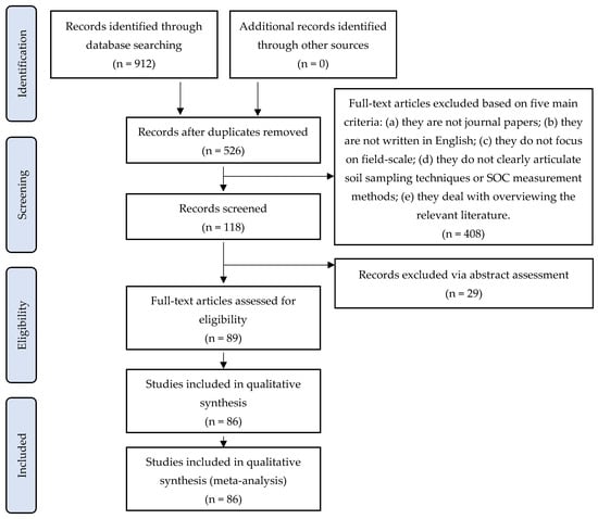 Figure 1. Flowchart illustrating the systematic review process used to select relevant papers.
 - Data extraction: Specific information, covering references (title, publishing year, and authors), scope, sampling and modeling approach, data sources, and relevant sampling details, were systematically documented in an online spreadsheet that all authors could access.
- Data analysis and results: The preliminary stage comprised a brief descriptive review of each paper, organized in tabular form and accompanied by statistical assessments.
- Findings interpretation: Drawing conclusions from the available scientific evidence was performed in relation to the primary RQs discussed above.
4. Results
4.1. Categorization of the Selected Studies Based on Their Main Features
Table 2 summarizes the 86 relevant studies on SOC sampling in chronological order, providing an overview of the evolution of methods and techniques in the field. Each column highlights critical aspects of SOC research, as follows:
Table 2.
Compilation of the reviewed studies on soil organic carbon sampling: methodological approaches, modeling, and data acquisition techniques.
- Reference: The citation for each study, including the first author names.
- Year: The year of publication.
- Approach: The sampling strategy employed in the study, classified as either design-based (DB) or model-based (MB), to differentiate between direct sampling efforts and those incorporating computational modeling.
- Sampling: The method used to gather SOC data, represented by abbreviations such as balanced sampling (BS), grid sampling (GS), random sampling (RS), and transect sampling (TS).
- Sampling details: Specific details provided about the sampling procedure, such as the number of samples (NS), depth interval (DI), sample density (SDEN), and the specific procedures used during sample collection.
- Modeling: The geostatistical or ML models used to process and analyze SOC data, such as several types of Kriging variants and regression algorithms for addressing specific challenges in SOC sampling.
- Data acquisition: The techniques or sensors used to obtain SOC data, including traditional laboratory methods (LAB), remote sensing approaches, and proximal spectroscopy.
4.2. Keyword Information Clustering
To gain a deeper understanding of the research landscape surrounding SOC assessment for carbon farming, a keyword clustering analysis was conducted. Approximately 430 keywords were extracted from 86 selected articles, with the ten most frequently used keywords presented in Figure 2, where font size reflects frequency.
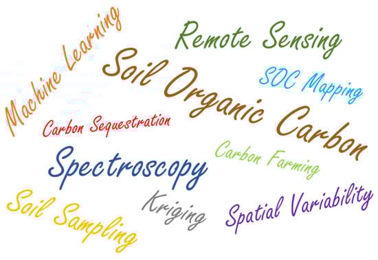
Figure 2.
Keyword clustering within the related literature.
The dominant keyword, “Soil Organic Carbon”, unsurprisingly aligns with the central theme of this review. Following closely in frequency is “Spectroscopy”, highlighting its pivotal role in SOC research. Spectroscopy encompasses a suite of techniques that analyze the interaction of electromagnetic radiation with soil samples, allowing for the rapid, non-destructive, and cost-effective determination of SOC content and composition. This method is particularly significant due to its ability to provide detailed information about the chemical properties of SOC, which are crucial for understanding carbon sequestration dynamics. The prevalence of “Spectroscopy” also signals a shift towards advanced analytical techniques that can provide more nuanced insights into SOC characteristics beyond simple quantification. Similarly, “Remote Sensing” emphasizes the increasing reliance on spatially explicit data for SOC assessment. By leveraging satellite and drone imagery, remote sensing enables the mapping and monitoring of SOC distribution at regional and global scales, addressing the challenges associated with traditional soil sampling methods.
“Soil Sampling” remains a significant keyword, stressing the necessity of ground-truth data for validating and calibrating spectroscopic and remote sensing models. The spatial variability inherent in SOC distribution, as indicated by the keyword “Spatial Variability”, necessitates strategic sampling designs to capture the heterogeneity of SOC across landscapes.
The prominence of “Machine Learning” and “Kriging” reflects the growing adoption of advanced computational and geostatistical techniques for modeling and predicting SOC distribution. ML algorithms can identify complex relationships between SOC and environmental factors, while Kriging provides robust geostatistical interpolation for spatial prediction. Finally, the keywords “Carbon Farming” and “Carbon Sequestration” emphasize the applied aspects of SOC research, focusing on developing practical strategies to enhance carbon storage in agricultural soils and mitigate climate change. This perspective is consistent with the growing recognition of agriculture’s potential to contribute to climate solutions through effective SOC management.
4.3. Chronological Distribution
Figure 3 illustrates the chronological distribution of the examined papers based on the methodological approach used between 2000 and 2024. In particular, the blue bars represent design-based work, which dominates most years. The orange segments indicate papers utilizing both design-based and model-based approaches, which start appearing from 2009 and show a remarkable increase from 2017 onwards. Green sections correspond to papers based exclusively on models, which appear infrequently and in 2019 and 2023. Overall, there is a clear trend of increasing publications over time, with a notable surge in the number of papers from 2017 onwards. This growth can be attributed to several factors, including advancements in remote sensing, proximal sensing technologies, and ML, as well as the significant increase in computing power and the availability of large datasets [47]. Additionally, policy initiatives promoting carbon sequestration and climate-smart agriculture, such as the Paris Agreement and national carbon farming programs, may have driven increased research interest [5]. While design-based approaches continue to stand out, there is a constant presence of papers that combine design-based and model-based methods. This signifies a growing recognition of the synergistic potential in combining empirical field data with predictive modeling, allowing for more robust analyses of complex systems and a deeper understanding of underlying processes. The small number of papers in 2024 is attributed to the timing of the final data collection for the present review.
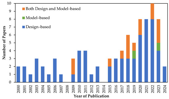
Figure 3.
Chronological distribution of the 86 examined papers according to the utilized approach.
4.4. Sampling Methods
The distribution of sampling methods presented in the reviewed papers employing design-based approaches, as shown in Figure 4, reflects a preference for grid sampling, which accounts for 44 papers in total. This method involves dividing the area into a systematic grid for uniform coverage. Random sampling follows with 26 papers indicating an effort to eliminate bias. Following closely with 24 papers, stratified sampling stresses the necessity to capture variations within specific subgroups, which is essential for studies involving diverse populations. Transect sampling, presented in 14 papers, is useful for investigating spatial changes along environmental gradients. Finally, balanced sampling, the least represented and found in two papers, aims to maintain an even distribution across different sample segments, hence enhancing the reliability of the findings. The general concepts of these sampling methods are analyzed in Section 2.2.4, while their main advantages and disadvantages are summarized in Table 1.
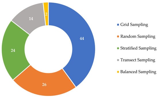
Figure 4.
Distribution of sampling methods used in papers employing design-based approaches.
In the pie chart of Figure 5, the distribution of modeling techniques employed in research papers that primarily utilize model-based approaches is depicted. The most frequently used method is k-means clustering, followed by conditioned Latin hypercube sampling (CLHS). Ward’s minimum variance, Kennard–Stone, and similarity analysis methods are less frequently used, with one occurrence each. K-means clustering is an unsupervised learning technique that organizes similar data points into distinct groups. This method allows for the identification of unique clusters among soil samples based on their characteristics, thereby improving the accuracy of SOC predictions. CLHS generates input values that represent the entire input space while adhering to specific constraints, which is valuable for exploring the effects of various predictor variables on SOC content. Ward’s minimum variance, a hierarchical clustering method, identifies groups of soil samples with similar SOC characteristics, providing insights into the factors driving SOC variability. The Kennard–Stone algorithm selects a representative subset of data points from a larger dataset, optimizing the training dataset for model efficiency and reducing computational demands. Lastly, similarity analysis encompasses various techniques for assessing the similarity or dissimilarity among data points, aiding in the identification of relationships that can inform model development and improve prediction outcomes in SOC studies.
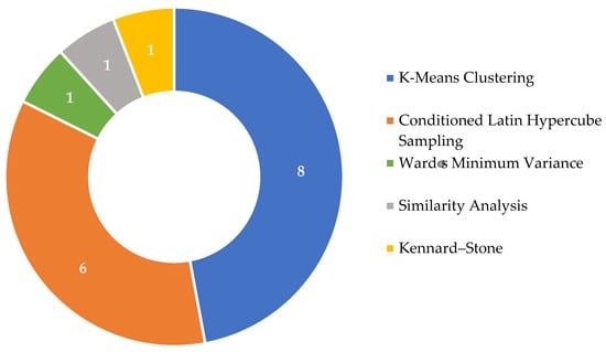
Figure 5.
Distribution of modeling techniques used in papers employing model-based approaches.
4.5. Sampling Details
To provide insights into the methodologies employed in the investigated studies, the distribution of various aspects of soil sampling is presented in Figure 6. Understanding sampling details aids in informing best practices for soil management and carbon sequestration strategies. In total, a strong interest is observed in topsoil sampling, which is important for accurately assessing SOC levels. Also, the focus on the number of samples indicates an effort to ensure adequate representation for reliable findings. Moreover, the inclusion of sample pre-treatment emphasizes the importance of preparing samples to reduce contamination and improve measurement accuracy. Timing of sampling is also essential for capturing seasonal variations in SOC, while the consideration of multiple locations gives emphasis to the need for spatial diversity in data collection. The mention of various tools and compositing techniques illustrates researchers’ commitment to standardizing procedures for enhanced data quality. In addition, the attention to depth intervals and subsoil sampling reflects a recognition of the significance of analyzing the entire soil profile. Horizon depth, sample density, and plough depth, though less frequently addressed, are still important factors for understanding soil variability.
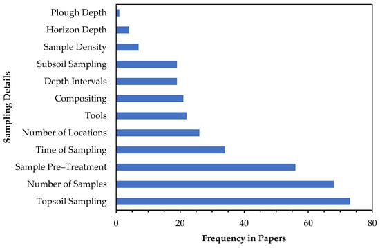
Figure 6.
Distribution of sampling details across the examined papers.
4.6. Modeling Methods
As can be seen in Figure 7, ML models are leading trends in SOC studies, with Kriging methods, however, still holding a significant place, while other methods, like inverse distance weighting (IDW) and a specific agroecosystem dynamic model called CENTURY [146], are used less frequently.

Figure 7.
Distribution of modeling methods across the examined papers.
4.6.1. Machine Learning Models
ML models have gained significant attention in SOC studies because of their ability to process vast amounts of data and capture complex, non-linear relationships between variables. Their flexibility has made them a valuable tool for addressing the spatial variability of SOC and predicting SOC levels across different landscapes [47]. ML is mainly used for regression tasks in SOC research for predicting SOC content based on various factors, including soil properties, land use, and climate conditions.
Among the most commonly used ML techniques, random forest (RF) is known for its robustness in handling high-dimensional data and its ability to rank variable importance, making it a popular choice for SOC modeling. However, RF can be computationally intensive, especially when dealing with large datasets. Support vector machines (SVMs) are also widely used, particularly for their strong predictive power in smaller datasets and their ability to model non-linear relationships. However, they require careful parameter tuning and are sensitive to noise. Artificial neural networks (ANNs) have demonstrated promising results in SOC studies due to their capacity to model highly complex interactions, yet they require large training datasets and substantial computational resources. More recently, gradient boosting methods, such as XGBoost and LightGBM, have gained attention for their efficiency and high accuracy in SOC prediction, often outperforming RF in terms of precision while maintaining interpretability.
As can be noted in Table 2, ML algorithms are leveraging data from remote sensing technologies, like satellites, UAVs, and aircraft, to support SOC research. These technologies provide imagery and spectral data that can capture spatial variations in soil properties and land cover. By integrating diverse data sources, such as remote sensing, soil properties, and climate data, ML provides more robust predictions of SOC distribution. The detailed SOC maps provided by ML algorithms can help identify “hotspots” for carbon storage, guiding decision-making in carbon sequestration strategies and carbon farming practices.
4.6.2. Kriging Models
As far as Kriging is concerned, it is a widely utilized geostatistical interpolation method used to estimate random variable values, such as soil properties, at unknown locations based on nearby known observations. The process involves statistical data analysis, variogram modeling, surface construction, and variance exploration [147]. Unlike deterministic models such as IDW [148], Kriging relies on autocorrelation to predict values and generate surfaces that reflect some uncertainty. For Kriging to provide the best linear unbiased predictions, it must satisfy two conditions; stationarity and isotropy, though these assumptions may vary depending on the specific Kriging method used [147,149]. Several variants of Kriging were found in the present analysis addressing different spatial patterns and complexities in SOC data, as follows:
- Ordinary Kriging: Estimates using spatial correlation assuming a constant, unknown mean across the study area; best for data with relatively uniform trends.
- Block Kriging: Averages estimates over defined blocks, smoothing results for regional assessments.
- Stratified Ordinary Kriging: Applies ordinary Kriging within pre-defined, homogeneous strata to account for known sub-regions.
- Simple Kriging with Local Means: Incorporates known local mean variations and is suitable for heterogeneous landscapes but requires accurate local mean data.
- Robust Ordinary Kriging: Minimizes the impact of outliers, providing more stable estimates in datasets with potential errors.
- Co-Kriging: Uses correlations between multiple variables to improve predictions of the target variable.
- Empirical Bayesian Kriging: Accounts for semivariogram uncertainty through simulations; useful for sparse data or complex spatial variability.
- Factorial Kriging: Decomposes spatial variability into multiple components; suitable for complex datasets with varied trends.
- Geographical Detector-based Stratified Regression Kriging: Integrates geographical detectors to identify influencing factors, then applies stratified regression Kriging.
- Kriging with External Drift: Incorporates auxiliary data (environmental factors) as a trend component to improve predictions.
- Kriging with a Trend: Models systematic trends alongside spatial correlation; effective in areas with gradients.
- Partial Least Squares Regression Kriging: Combines regression with Kriging for high-dimensional datasets.
- Random Forest–Ordinary Kriging: Blends random forest’s non-linear modeling with ordinary Kriging’s spatial interpolation.
- Regression Kriging: Combines regression for non-spatial factors with Kriging for spatial residuals.
While some of these are purely geostatistical methods, some are hybrid models that integrate Kriging with other techniques like regression, machine learning, or auxiliary data to enhance predictions and capture more complexity.
4.6.3. Inverse Distance Weighting
IDW was less common, appearing in three papers [87,96,121]. IDW is a spatial interpolation method normally used in SOC research to estimate SOC values at non-sampled locations based on nearby measured points. The method assumes that nearby points have a stronger impact on the predicted value compared to points that are farther away. This approach is particularly useful when there is a limited number of SOC samples, allowing researchers to create smooth maps of SOC distribution and estimate SOC variability across large areas.
4.6.4. CENTURY Agroecosystem Dynamic Model
Finally, two studies [64,79] utilized the CENTURY model [146]. This is a plant–soil nutrient cycle process-based model that simulates the long-term carbon, nitrogen, and other nutrient dynamics in various ecosystems. It uses a mechanistic approach incorporating ecological and biogeochemical processes, such as photosynthesis, respiration, decomposition, nutrient cycling, and plant growth. CENTURY also models soil organic matter, dividing it into active, slow, and passive pools, each of these with different turnover rates as affected by environmental conditions, too.
4.7. Data Acquisition
4.7.1. Conventional Laboratory Measurements
As can be deduced from Table 2, laboratory measurements were the most common method of data acquisition, cited in 82 studies. SOC content was calculated directly in 55 of these studies, while others used indirect methods. Organic matter content was measured in 4 studies, total carbon in 18, inorganic carbon in 12, and total organic carbon in 11. Particulate organic matter and oxidizable carbon were analyzed in one and three studies, respectively. Laboratory measurements are fundamental in providing accurate and reliable data that serve as reference data for other measurement approaches. They can be broadly divided into two main categories, namely oxidation-based and combustion-based methods. The former method involves chemically oxidizing organic carbon in the soil. One common method is Walkley–Black, which was used in 10 studies, where SOC is oxidized using potassium dichromate in the presence of sulfuric acid, and the amount of carbon is estimated based on a chemical reaction [150]. Concerning the combustion-based methods, the soil sample is combusted at high temperatures, typically using an instrument like a dry combustion analyzer. The carbon in the sample is converted to CO2, which is then measured to estimate the total organic carbon content [151]. Dry combustion, including the Dumas method, was applied in 25 studies.
Less commonly, the loss on ignition and the total combustion–Scheibler method were each used in one study. Additionally, air-drying, sieving, and thorough mixing were the main sample pre-treatment methods performed in most of the studies. Bulk density measurements, essential for calculating carbon stocks, were reported in 25 papers. Eleven studies measured gravel content during soil texture analysis, which also included clay, sand, and silt measurements, primarily determined using the pipette method. Excluding gravel content from the calculation allowed for a more accurate estimation of SOC stocks. Other laboratory measurements were also commonly conducted, with pH measured in 16 studies, nitrogen and water content in 11 studies, cation exchange capacity and potassium in 5, electrical conductivity and phosphorus in 4, and calcium carbonate (CaCO₃) in 3 studies.
Traditional laboratory methods are frequently characterized by time-consuming processes that may not meet the growing demand for high-throughput analyses in contemporary research. In order to highlight the trends shaping the future of SOC measurement, Figure 8 offers a visual representation of the distribution of the other reported techniques. These methods provide complementary approaches that significantly broaden the scope of SOC research. The graph is divided into four main categories (represented by separate bars): (a) spectroscopy; (b) remote sensing; (c) historical inventory; and (d) other techniques.

Figure 8.
Distribution of data acquisition methods that supplement conventional laboratory methods across the examined papers.
Overall, spectroscopy (both proximal and ex situ) and remote sensing techniques are the most frequently used methods, indicating their significance in SOC research, while historical inventory and other techniques are also used in SOC research. These findings stress the complex nature of SOC dynamics and emphasize the importance of multi-methodological approaches to address diverse research questions. As shown in Table 2, laboratory and remote sensing techniques are commonly employed, reflecting the need for both precise, field-based measurements and large-scale, spatial data collection. By combining these methods, researchers can gain a deeper understanding of SOC variability, integrating detailed soil properties with broader environmental patterns captured through remote sensing. This combination enables more accurate SOC mapping and predictions, supporting efforts in carbon farming strategies.
4.7.2. Spectroscopy
Concerning spectroscopy, in the context of SOC research, it works by analyzing the interaction between light and soil matter to determine its composition. Different types of spectroscopy, like NIR, MIR, and VNIR, use specific wavelengths of light to measure the reflectance or absorption of soil samples. These measurements provide information about the chemical and physical properties of the soil, including SOC content. Spectroscopy is particularly useful in mapping SOC across large areas without needing extensive laboratory-based chemical analysis. In the present analysis, the most frequently used method was VNIR spectroscopy (21 instances), which is effective in assessing SOC content through reflectance patterns in the visible and near-infrared spectrum. NIR follows, similarly focusing on soil reflectance but with a narrower infrared range. MIR spectroscopy delves deeper, providing precise identification of organic compounds within the soil. Infrared spectroscopy and X-ray fluorescence extend the range of analyses, with the latter offering elemental composition insights. Less commonly used were gamma radiometric, diffuse reflectance infrared Fourier transform, and laser-induced breakdown spectroscopy (one instance each). All of them contribute specialized data for analyzing SOC.
4.7.3. Remote Sensing
In SOC research, remote sensing platforms, such as satellites, aircraft, and UAVs, are increasingly important for efficiently monitoring and mapping large areas. Satellites emerged as the most frequently utilized method in the present analysis, reflecting their ability to cover extensive areas and provide long-term data collection, which is crucial for understanding regional SOC dynamics. Aircraft were used less often, yet they offer higher resolution imagery and greater flexibility for specific studies, allowing researchers to capture detailed data in targeted locations. UAVs, while the least used in this context, present a cost-effective solution for collecting high-resolution data over smaller areas, making them ideal for localized SOC assessments.
4.7.4. Historical Inventory
The third bar in Figure 8, which represents historical inventory, is used less frequently but still offers valuable insights into past land use practices, agricultural activities, and historical changes in vegetation cover. By examining these historical data, researchers can enhance their understanding of current SOC patterns and identify long-term trends. Specifically, soil inventory plays a fundamental role in SOC research by informing researchers about the spatial distribution of soil properties. Meanwhile, historical management data shed light on the effects of past land management practices on soil health and carbon storage, highlighting its significance in developing sustainable land management strategies.
4.7.5. Other Techniques
In the category of “Other Techniques”, the use of LIDAR, electromagnetic induction, and ground-penetrating radar demonstrates a valuable yet less frequent approach in SOC research. LIDAR provides high-resolution topographic data, allowing researchers to analyze vegetation structure and terrain features that influence SOC dynamics. Electromagnetic induction enables non-invasive assessments of soil properties by measuring electrical conductivity, offering insights into factors like moisture content that affect SOC storage. Though ground-penetrating radar is utilized even less frequently, it serves to visualize subsurface soil structures, assisting in the examination of soil horizons and their carbon relationships. Although these techniques are not as commonly employed as others, they have an important impact on enhancing the understanding of SOC dynamics and can complement more prevalent methods for a comprehensive analysis.
4.7.6. Ex Situ, Proximal, and Remote Sensing Categorization
Focusing on sensing techniques, they can be roughly divided into three categories: (a) ex situ sensing, which involves laboratory analyses of soil samples collected from the field, allowing for the detailed examination of soil properties and validation of other data sources; (b) proximal sensing, referring to techniques that gather data at close range using handheld instruments, providing high-resolution, site-specific information directly in the field; and (c) remote sensing, which utilizes aerial or satellite technologies to collect data over larger areas, enabling the monitoring of soil characteristics and changes over time at a landscape level. As can be seen in Figure 9, proximal and remote sensing are the most frequently utilized methods in SOC research, with a notable number of studies. Their widespread adoption in research can be attributed to technological advancements recently that have enhanced data accuracy and accessibility. Finally, ex situ sensing, while the least employed of the three, still holds significant importance by validating and complementing findings from proximal and remote sensing. Overall, these results emphasize the importance of integrating multiple techniques for reliable SOC assessments.
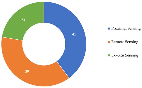
Figure 9.
Distribution of sensing techniques across the examined papers.
5. Discussion
5.1. RQ1: What Are the State-of-the-Art Approaches in Sampling, Modeling, and Data Acquisition?
The exploration of methodologies in SOC research that was conducted in this analysis reveals a notable emphasis on diverse sampling techniques, modeling methods, and data acquisition strategies. Traditional laboratory analyses still remain important for providing accurate and reliable baseline data.
In short, publication trends show a significant increase over time, particularly from 2017 onward. Interestingly, although design-based approaches remain prevalent, there is a growing trend of integrating model-based methods in recent studies. This evolution indicates an increasing focus on combining these methodologies. Regarding the distribution of sampling methods, it indicates a clear preference for grid sampling, which suggests a targeted, structured approach in specific study areas. Random, stratified, transect, and balanced sampling follow in order of decreasing frequency. The analysis of modeling techniques in model-based research displays that k-means clustering is the most frequently used method, followed by CLHS. Ward’s minimum variance, similarity analysis, and Kennard–Stone methods are less common. In addition, a strong focus on topsoil sampling is observed, which is essential for accurately assessing SOC levels. The number of samples collected from several sites indicates an effort to ensure the reliability of the findings and spatial diversity, and pre-treatment procedures, vital for reducing contamination, follow. Finally, sampling timing was also frequently used in the relevant literature to capture seasonal variations.
Notably, modeling methods demonstrate a substantial shift toward ML algorithms, particularly in recent years, primarily focused on regression approaches. This shift is largely driven by the increasing demand to analyze complex and large datasets and capture relationships among variables for predicting SOC levels and spatial variability. In this direction, ML algorithms, such as RF and SVM, have been pivotal in identifying patterns. However, Kriging remains an important interpolation method, allowing for the estimation of soil properties based on spatial relationships and thus providing valuable predictions in areas with varying complexities.
In terms of data acquisition, laboratory measurements are the predominant method cited across numerous studies. These conventional approaches provide essential baseline data for SOC assessments. Furthermore, other techniques, such as spectroscopy (both ex situ and proximal) and remote sensing, have emerged as integral components of SOC research, enabling efficient and comprehensive data collection over larger areas. These methods, typically used as supplementary methods, both enhance the accuracy of SOC measurements and facilitate the integration of spatial data, ultimately improving predictive capabilities. Overall, the convergence of innovative sampling strategies, modeling techniques, and multi-faceted data acquisition methods calls attention to a transformative period in SOC research. By leveraging these state-of-the-art approaches, researchers are better equipped to address the complexities of SOC dynamics, contributing to effective carbon farming strategies [24].
5.2. RQ2: What Are the Key Challenges, Open Issues, Potential Advancements, and Research Directions Needed to Enhance the Effectiveness of Carbon Farming Practices?
The ongoing research into SOC sampling methodologies has illuminated a range of challenges and open issues that should be addressed towards optimizing future carbon farming strategies. These challenges arise from the inherent complexities of SOC dynamics and the integration of various sampling and modeling approaches.
One of the primary challenges in SOC research is the inherent complexity in characterizing agricultural ecosystems, as soils are heterogeneous and demonstrate both spatial and temporal variability. This remarkable variability complicates the design of sampling strategies that accurately represent SOC levels across different landscapes and track changes over time. Determining the optimal frequency of SOC monitoring depends on factors like the rate of carbon turnover, land management practices (such as tillage and fertilizer use), and the specific objectives of the carbon farming project. Moreover, unpredictable natural events, including droughts and floods, can significantly disrupt SOC stocks. Climate change introduces extra uncertainty, as shifting weather patterns can alter the ability of soils to sequester carbon.
The common denominator of all efforts for facilitating carbon farming is that reliable methodologies are necessary to evaluate the effectiveness of carbon farming practices over time. Direct measurement methods have significantly advanced our understanding of carbon cycling in agroecosystems. However, they face several limitations that hinder their practicality and scalability. One major challenge is the high financial and labor costs associated with these techniques, making it impractical to apply them across large areas or at the field level on a regular basis. In particular, laboratory analysis, while widely regarded as one of the most reliable methods for verifying SOC outcomes, is labor-intensive. It also involves complex processes, such as measuring SOC concentration through dry combustion and calculating bulk density. Additionally, although advances like laboratory-based spectroscopy have reduced some costs, in situ technologies remain less accurate than traditional methods, further limiting their effectiveness [152,153].
Direct measurements also face challenges in capturing the aforementioned spatial variability of SOC within a field, as well as the uncertainty introduced by year-to-year fluctuations. This makes them unsuitable for short-term monitoring but useful for establishing baselines or conducting periodic verifications over long periods. In addition, direct measurement methods are not ideal for assessing changes in SOC fluxes compared to a “business-as-usual” scenario [154] since they cannot simultaneously capture both the effects of a new practice and the hypothetical baseline for comparison. For instance, when evaluating practices like cover cropping, the “additionality” requirement for carbon credits demands a comparison of SOC levels under the new practice and the counterfactual scenario. While SOC under the new practice can be directly measured, the “business-as-usual” scenario cannot be directly observed and should be modeled instead.
Remote sensing technologies (especially hyperspectral imaging) have demonstrated promise in monitoring SOC. Nevertheless, their implementation for monitoring SOC in actual field conditions presents significant challenges. One major limitation is that remote sensing primarily captures data on SOC and related properties only at the surface level, failing to provide insights into the full depth of the soil profile. Additionally, factors such as crop residues, green plant cover, and soil moisture can considerably interfere with spectral readings, complicating the accurate estimation of carbon concentrations in bare soil surfaces [155].
Regarding the emission factor methods for estimating SOC, they involve quantifying carbon emissions or sequestration based on predefined coefficients that reflect average carbon dynamics associated with specific agricultural practices or land uses. These coefficients, often derived from empirical studies, represent the expected changes in SOC per unit of land area or agricultural output, making them suitable for large-scale carbon accounting. While these methods simplify calculations and allow for the scaling of estimates across broader regions, they also have noteworthy limitations. They often fail to capture spatial and temporal variability, leading to potential inaccuracies, and may discourage farmer participation in carbon markets due to their generalized assumptions about carbon dynamics [156]. Commonly referenced emission factors include those provided by the IPCC, which offer standardized values for various agricultural practices and their carbon impacts.
Process-based modeling can simulate both “business-as-usual” and counterfactual scenarios, thereby addressing some of the limitations associated with the above methods. Nonetheless, existing modeling approaches have significant challenges that need to be addressed. One major issue is the absence of essential processes and the lack of constraints that can reduce uncertainties in model parameters. Many process-based models do not incorporate observational constraints, especially in locations that extend beyond their calibration sites. The effectiveness of these models mainly hinges on two types of parameters: (a) process-specific parameters, which remain constant over space and time, and (b) location-specific parameters, which vary by location [157]. While the former parameters can often be calibrated using extensive laboratory or field data, location-specific parameters, such as photosynthetic capacity, are critical for the model’s scalability. In addition, many models neglect the spatial and temporal variability of these parameters, leading to significant errors in carbon estimations. Additionally, location-specific inputs, such as local weather, soil properties, and management practices, are essential for achieving accurate field-level assessments. The absence of these crucial location-specific details represents a significant source of uncertainty in quantifying SOC outcomes accurately.
In summary, quantifying carbon outcomes involves a trade-off between cost and accuracy, with scalable technologies needing to maintain operational costs significantly below expected monetized carbon values. In the U.S. carbon market, for instance, this translates to costs under $10 per acre per year (encompassing the setup, calibration, functioning, and overall lifespan of the hardware) while achieving less than 20% error in SOC quantification [158]. No existing technology meets these criteria alone; therefore, a more effective solution seems to be the “System-of-Systems” approach, which integrates sampling, sensing, and modeling [156]. This holistic framework includes several key features, including (a) the scalable gathering of ground truth data along with cross-scale sensing of crop, environmental, and management-related information at the local field level; (b) sophisticated modeling that includes essential processes for accurately measuring carbon outcomes; (c) methodical model–data fusion, which utilizes robust techniques to combine sensor data and models at the individual farm level; (d) high computational efficiency and the application of artificial intelligence (AI) to facilitate scalability across a number of fields at a low cost; and (e) efficient multi-tier validation systems and infrastructures to evaluate the scalability of the model or solution, ensuring reliable performance with acceptable accuracy across all targeted fields.
Figure 10 illustrates a qualitative comparison of different technological methods used to measure SOC levels at the field level based on [156,158]. The methods are categorized in accordance with their accuracy and cost. On both horizontal (accuracy) and vertical (cost) axes, the corresponding magnitudes increase from low to high. This results in a rough classification of methodologies into the following regimes: “fail”, “cost to be reduced”, “accuracy to be improved”, and “preferred”. Overall, methods with higher accuracy, such as soil sampling, tend to be more expensive. In contrast, lower-cost methods, like emission factor methods, satellite imagery, and data-driven models, often compromise on accuracy. The preferred quadrant (in green) indicates the ideal combination of high accuracy and low cost. This occurs where methods like the system-of-systems approach may reside, integrating multiple technologies to optimize both cost and accuracy. Finally, methods such as UAV and ground sensing are at the intersection of “fail” with “accuracy to be improved” and “cost to be reduced”, respectively. Consequently, while they offer intermediate accuracy potential, they often face challenges, including data processing complexity and time-consuming analysis. Additionally, weather conditions and terrain variations can affect the quality and consistency of data collected.
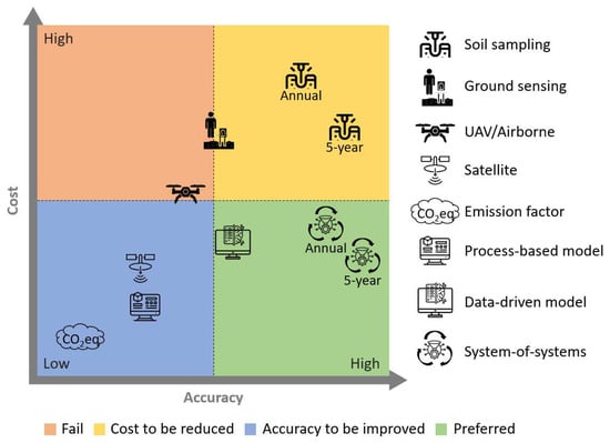
Figure 10.
Qualitative representation of how various technological approaches for measuring carbon outcomes at the field level are positioned within a diagram that balances accuracy and cost.
Building on the challenges and advancements discussed, several key future directions can enhance the effectiveness of SOC assessment and carbon farming implementation. Table 3 ties together practical aspects like farmer engagement, policy support, and market access with the technical research directions needed to improve SOC monitoring, accuracy, and scaling.
Table 3.
Future research directions for advancing soil organic carbon assessment methodologies and carbon farming implementation.
6. Conclusions
This study provides a review of state-of-the-art methodologies for SOC sampling, modeling, and data acquisition. While traditional methods remain crucial, the shift towards ML-based techniques and remote sensing technologies is transforming SOC research. However, the high financial costs and measurement inaccuracies associated with SOC monitoring present significant barriers to carbon farming adoption. Laboratory-based measurements, though accurate, are expensive and labor-intensive, making frequent assessments impractical, particularly for small-scale farmers who may struggle to afford them. This limits their ability to verify SOC gains and access carbon credit programs, reducing financial incentives for sustainable practices. On the other hand, remote sensing and model-based approaches, while more scalable, often suffer from accuracy limitations. These inaccuracies can lead to the underestimation of SOC sequestration, potentially causing lower carbon credit earnings for farmers. Overestimation, on the other hand, risks market credibility. Regarding emission factor methods, they rely on standardized coefficients that fail to capture site-specific SOC dynamics, potentially undervaluing sequestration efforts and discouraging participation in carbon markets. Finally, emission factor methods rely on standardized coefficients that fail to capture site-specific SOC dynamics, potentially undervaluing sequestration efforts and discouraging participation in carbon markets. As a consequence, farmers may hesitate to invest in carbon farming practices without reliable, cost-effective measurement solutions that ensure fair compensation and market stability.
In conclusion, the adoption of scalable, cost-efficient, and precise technologies, combined with supportive policies and farmer incentives, is critical to unlocking carbon farming’s potential. Monetizing carbon sequestration can encourage farmers to adopt these practices while tapping into the expanding market centered on climate action. A promising step forward is the development of a “System-of-Systems” approach that effectively balances cost and accuracy. An essential future direction lies in advancing techniques through collaboration among policymakers, farmers, and the private sector. By embracing this multidisciplinary approach to bridging the gap between research and practice, more practical and impactful solutions can be created to accelerate carbon farming adoption and contribute to more sustainable agriculture.
Author Contributions
Conceptualization, D.B. and T.P.; methodology, T.P. and G.K.; investigation, L.B., P.B., D.K., G.K. and T.P.; writing—original draft preparation, L.B. and T.P.; writing—review and editing, L.B., T.P., D.A., P.B. and D.B.; visualization, L.B., D.K. and P.B.; supervision, D.B. All authors have read and agreed to the published version of the manuscript.
Funding
This research received no external funding.
Data Availability Statement
Not applicable.
Conflicts of Interest
Authors Theodoros Petropoulos, George Kyriakarakos, and Dionysis Bochtis were employed by the company farmB Digital Agriculture S.A. The remaining authors declare that the research was conducted in the absence of any commercial or financial relationships that could be construed as potential conflicts of interest.
References
- Ma, Y.; Woolf, D.; Fan, M.; Qiao, L.; Li, R.; Lehmann, J. Global crop production increase by soil organic carbon. Nat. Geosci. 2023, 16, 1159–1165. [Google Scholar] [CrossRef]
- Francaviglia, R.; Almagro, M.; Vicente-Vicente, J.L. Conservation Agriculture and Soil Organic Carbon: Principles, Processes, Practices and Policy Options. Soil Syst. 2023, 7, 17. [Google Scholar] [CrossRef]
- Zhou, S.; Li, P.; Zhang, Y. Factors influencing and changes in the organic carbon pattern on slope surfaces induced by soil erosion. Soil Tillage Res. 2024, 238, 106001. [Google Scholar] [CrossRef]
- Food and Agriculture Organization of the United Nations. RECSOIL: Recarbonization of Global Agricultural Soils; Food and Agriculture Organization of the United Nations: Rome, Italy, 2024. [Google Scholar]
- Rumpel, C.; Amiraslani, F.; Koutika, L.-S.; Smith, P.; Whitehead, D.; Wollenberg, E. Put more carbon in soils to meet Paris climate pledges. Nature 2018, 564, 32–34. [Google Scholar] [CrossRef]
- Paul, C.; Bartkowski, B.; Dönmez, C.; Don, A.; Mayer, S.; Steffens, M.; Weigl, S.; Wiesmeier, M.; Wolf, A.; Helming, K. Carbon farming: Are soil carbon certificates a suitable tool for climate change mitigation? J. Environ. Manag. 2023, 330, 117142. [Google Scholar] [CrossRef]
- Van Hoof, S. Climate Change Mitigation in Agriculture: Barriers to the Adoption of Carbon Farming Policies in the EU. Sustainability 2023, 15, 10452. [Google Scholar] [CrossRef]
- Kwiatkowski, C.A.; Pawłowska, M.; Harasim, E.; Pawłowski, L. Strategies of Climate Change Mitigation in Agriculture Plant Production—A Critical Review. Energies 2023, 16, 4225. [Google Scholar] [CrossRef]
- Sharma, P.; Sharma, P.; Thakur, N. Sustainable farming practices and soil health: A pathway to achieving SDGs and future prospects. Discov. Sustain. 2024, 5, 250. [Google Scholar] [CrossRef]
- Nordbeck, R.; Hogl, K. National peatland strategies in Europe: Current status, key themes, and challenges. Reg. Environ. Change 2023, 24, 5. [Google Scholar] [CrossRef]
- Quevedo-Cascante, M.; Mogensen, L.; Kongsted, A.G.; Knudsen, M.T. How does Life Cycle Assessment capture the environmental impacts of agroforestry? A systematic review. Sci. Total Environ. 2023, 890, 164094. [Google Scholar] [CrossRef]
- European Commission. European Green Deal: Commission Proposals to Remove, Recycle and Sustainably Store Carbon; European Commission: Brussels, Belgium, 2021. [Google Scholar]
- Lampridi, M.; Sørensen, C.; Bochtis, D. Agricultural Sustainability: A Review of Concepts and Methods. Sustainability 2019, 11, 5120. [Google Scholar] [CrossRef]
- Raina, N.; Zavalloni, M.; Viaggi, D. Incentive mechanisms of carbon farming contracts: A systematic mapping study. J. Environ. Manag. 2024, 352, 120126. [Google Scholar] [CrossRef]
- Odebiri, O.; Odindi, J.; Mutanga, O. Basic and deep learning models in remote sensing of soil organic carbon estimation: A brief review. Int. J. Appl. Earth Obs. Geoinf. 2021, 102, 102389. [Google Scholar] [CrossRef]
- Pouladi, N.; Gholizadeh, A.; Khosravi, V.; Borůvka, L. Digital mapping of soil organic carbon using remote sensing data: A systematic review. Catena 2023, 232, 107409. [Google Scholar] [CrossRef]
- Radočaj, D.; Gašparović, M.; Jurišić, M. Open Remote Sensing Data in Digital Soil Organic Carbon Mapping: A Review. Agriculture 2024, 14, 1005. [Google Scholar] [CrossRef]
- Li, T.; Cui, L.; Wu, Y.; McLaren, T.I.; Xia, A.; Pandey, R.; Liu, H.; Wang, W.; Xu, Z.; Song, X.; et al. Soil Organic Carbon Estimation via Remote Sensing and Machine Learning Techniques: Global Topic Modeling and Research Trend Exploration. Remote Sens. 2024, 16, 3168. [Google Scholar] [CrossRef]
- Croft, H.; Kuhn, N.J.; Anderson, K. On the use of remote sensing techniques for monitoring spatio-temporal soil organic carbon dynamics in agricultural systems. Catena 2012, 94, 64–74. [Google Scholar] [CrossRef]
- Senesi, G.S.; Senesi, N. Laser-induced breakdown spectroscopy (LIBS) to measure quantitatively soil carbon with emphasis on soil organic carbon. A review. Anal. Chim. Acta 2016, 938, 7–17. [Google Scholar] [CrossRef]
- Angelopoulou, T.; Balafoutis, A.; Zalidis, G.; Bochtis, D. From Laboratory to Proximal Sensing Spectroscopy for Soil Organic Carbon Estimation—A Review. Sustainability 2020, 12, 443. [Google Scholar] [CrossRef]
- Allen, D.E.; Pringle, M.J.; Page, K.L.; Dalal, R.C. A review of sampling designs for the measurement of soil organic carbon in Australian grazing lands. Rangel. J. 2010, 32, 227–246. [Google Scholar] [CrossRef]
- Zhang, Y.; Hartemink, A.E. Sampling designs for soil organic carbon stock assessment of soil profiles. Geoderma 2017, 307, 220–230. [Google Scholar] [CrossRef]
- Kyriakarakos, G.; Petropoulos, T.; Marinoudi, V.; Berruto, R.; Bochtis, D. Carbon Farming: Bridging Technology Development with Policy Goals. Sustainability 2024, 16, 1903. [Google Scholar] [CrossRef]
- Davis, M.R.; Alves, B.J.R.; Karlen, D.L.; Kline, K.L.; Galdos, M.; Abulebdeh, D. Review of soil organic carbon measurement protocols: A US and Brazil comparison and recommendation. Sustainability 2018, 10, 53. [Google Scholar] [CrossRef]
- Olson, K.R. Soil organic carbon sequestration, storage, retention and loss in U.S. croplands: Issues paper for protocol development. Geoderma 2013, 195–196, 201–206. [Google Scholar] [CrossRef]
- Rakesh, S.; Sarkar, D.; Shikha; Sankar, A.; Sinha, A.K.; Mukhopadhyay, P.; Rakshit, A. Protocols for Determination and Evaluation of Organic Carbon Pools in Soils Developed Under Contrasting Pedogenic Processes and Subjected to Varying Management Situations; BT—Soil Analysis: Recent Trends and Applications; Springer: Singapore, 2020; pp. 87–105. ISBN 978-981-15-2039-6. [Google Scholar]
- Campbell, E.E.; Paustian, K. Current developments in soil organic matter modeling and the expansion of model applications: A review. Environ. Res. Lett. 2015, 10, 123004. [Google Scholar] [CrossRef]
- Lamichhane, S.; Kumar, L.; Wilson, B. Digital soil mapping algorithms and covariates for soil organic carbon mapping and their implications: A review. Geoderma 2019, 352, 395–413. [Google Scholar] [CrossRef]
- Ramesh, T.; Bolan, N.S.; Kirkham, M.B.; Wijesekara, H.; Kanchikerimath, M.; Srinivasa Rao, C.; Sandeep, S.; Rinklebe, J.; Ok, Y.S.; Choudhury, B.U.; et al. Chapter One—Soil organic carbon dynamics: Impact of land use changes and management practices: A review. Adv. Agron. 2019, 156, 1–107. [Google Scholar]
- Haddaway, N.R.; Hedlund, K.; Jackson, L.E.; Kätterer, T.; Lugato, E.; Thomsen, I.K.; Jørgensen, H.B.; Isberg, P.E. How does tillage intensity affect soil organic carbon? A systematic review. Environ. Evid. 2017, 6, 30. [Google Scholar] [CrossRef]
- Nazir, M.J.; Li, G.; Nazir, M.M.; Zulfiqar, F.; Siddique, K.H.M.; Iqbal, B.; Du, D. Harnessing soil carbon sequestration to address climate change challenges in agriculture. Soil Tillage Res. 2024, 237, 105959. [Google Scholar] [CrossRef]
- She, R.; Yu, Y.; Ge, C.; Yao, H. Soil Texture Alters the Impact of Salinity on Carbon Mineralization. Agronomy 2021, 11, 128. [Google Scholar] [CrossRef]
- Zhang, X.; Han, X.; Yu, W.; Wang, P.; Cheng, W. Priming effects on labile and stable soil organic carbon decomposition: Pulse dynamics over two years. PLoS ONE 2017, 12, e0184978. [Google Scholar] [CrossRef] [PubMed]
- Gross, A.; Bromm, T.; Glaser, B. Soil Organic Carbon Sequestration after Biochar Application: A Global Meta-Analysis. Agronomy 2021, 11, 2474. [Google Scholar] [CrossRef]
- Abagandura, G.O.; Sekaran, U.; Singh, S.; Singh, J.; Ibrahim, M.A.; Subramanian, S.; Owens, V.N.; Kumar, S. Intercropping kura clover with prairie cordgrass mitigates soil greenhouse gas fluxes. Sci. Rep. 2020, 10, 7334. [Google Scholar] [CrossRef] [PubMed]
- Singh, M.; Sarkar, B.; Biswas, B.; Bolan, N.S.; Churchman, G.J. Relationship between soil clay mineralogy and carbon protection capacity as influenced by temperature and moisture. Soil Biol. Biochem. 2017, 109, 95–106. [Google Scholar] [CrossRef]
- Wang, M.; Zhang, S.; Guo, X.; Xiao, L.; Yang, Y.; Luo, Y.; Mishra, U.; Luo, Z. Responses of soil organic carbon to climate extremes under warming across global biomes. Nat. Clim. Change 2024, 14, 98–105. [Google Scholar] [CrossRef]
- Saint-Laurent, D.; Gervais-Beaulac, V.; Paradis, R.; Arsenault-Boucher, L.; Demers, S. Distribution of Soil Organic Carbon in Riparian Forest Soils Affected by Frequent Floods (Southern Québec, Canada). Forests 2017, 8, 124. [Google Scholar] [CrossRef]
- Soares, P.R.; Harrison, M.T.; Kalantari, Z.; Zhao, W.; Ferreira, C.S.S. Drought effects on soil organic carbon under different agricultural systems. Environ. Res. Commun. 2023, 5, 112001. [Google Scholar] [CrossRef]
- Lobsey, C.R.; Viscarra Rossel, R.A. Sensing of soil bulk density for more accurate carbon accounting. Eur. J. Soil Sci. 2016, 67, 504–513. [Google Scholar] [CrossRef]
- Food and Agriculture Organization of the United Nations. Focus | Measuring and Modelling Soil Carbon Stocks and Stock Changes in Livestock Production Systems. Guidelines for Assessment; Food and Agriculture Organization of the United Nations: Rome, Italy, 2019. [Google Scholar]
- Mudge, P.; McNeill, S.; Hedley, C.B.; Roudier, P.; Poggio, M.; Whenua, M.; Malone, B.; Baldock, J.; Smith, P.; Trust, P.; et al. Design of an On-Farm Soil Carbon Benchmarking and Monitoring Approach for Individual Pastoral Farms; Ministry for Primary Industries: Wellington, New Zealand, 2020. [Google Scholar]
- Gold Standard for the Global Goals. Soil Organic Carbon Framework Methodology; Gold Standard for the Global Goals: Geneva, Switzerland, 2020. [Google Scholar]
- Lawrence, P.G.; Roper, W.; Morris, T.F.; Guillard, K. Guiding soil sampling strategies using classical and spatial statistics: A review. Agron. J. 2020, 112, 493–510. [Google Scholar] [CrossRef]
- Eggleston, H.S.; Buendia, L.; Miwa, K.; Ngara, T.; Tanabe, K. 2006 IPCC Guidelines for National Greenhouse Gas Inventories; IPCC: Kyoto, Japan, 2006. [Google Scholar]
- Benos, L.; Tagarakis, A.C.; Dolias, G.; Berruto, R.; Kateris, D.; Bochtis, D. Machine Learning in Agriculture: A Comprehensive Updated Review. Sensors 2021, 21, 3758. [Google Scholar] [CrossRef]
- Liakos, K.G.; Busato, P.; Moshou, D.; Pearson, S.; Bochtis, D. Machine learning in agriculture: A review. Sensors 2018, 18, 2674. [Google Scholar] [CrossRef]
- Pierson, D.; Lohse, K.A.; Wieder, W.R.; Patton, N.R.; Facer, J.; de Graaff, M.A.; Georgiou, K.; Seyfried, M.S.; Flerchinger, G.; Will, R. Optimizing process-based models to predict current and future soil organic carbon stocks at high-resolution. Sci. Rep. 2022, 12, 10824. [Google Scholar] [CrossRef] [PubMed]
- Sedlář, O.; Balík, J.; Černý, J.; Kulhánek, M.; Smatanová, M. Long-Term Application of Organic Fertilizers in Relation to Soil Organic Matter Quality. Agronomy 2023, 13, 175. [Google Scholar] [CrossRef]
- Zayani, H.; Fouad, Y.; Michot, D.; Kassouk, Z.; Baghdadi, N.; Vaudour, E.; Lili-Chabaane, Z.; Walter, C. Using Machine-Learning Algorithms to Predict Soil Organic Carbon Content from Combined Remote Sensing Imagery and Laboratory Vis-NIR Spectral Datasets. Remote Sens. 2023, 15, 4264. [Google Scholar] [CrossRef]
- Mustapha, A.A.; Abdu, N.; Oyinlola, E.Y.; Nuhu, A.A. Evaluating Different Methods of Organic Carbon Estimation on Nigerian Savannah Soils. J. Soil Sci. Plant Nutr. 2023, 23, 790–800. [Google Scholar] [CrossRef]
- Loria, N.; Lal, R.; Chandra, R. Handheld In Situ Methods for Soil Organic Carbon Assessment. Sustainability 2024, 16, 5592. [Google Scholar] [CrossRef]
- Murad, M.O.F.; Ackerson, J.; Tolles, C.; Meissner, K.; Morgan, C.L.S.; Ge, Y. Estimating soil organic carbon content at variable moisture contents using a low-cost spectrometer. Geoderma 2023, 440, 116723. [Google Scholar] [CrossRef]
- Pathirana, S.; Lambot, S.; Krishnapillai, M.; Cheema, M.; Smeaton, C.; Galagedara, L. Ground-Penetrating Radar and Electromagnetic Induction: Challenges and Opportunities in Agriculture. Remote Sens. 2023, 15, 2932. [Google Scholar] [CrossRef]
- Tagarakis, A.C.; Filippou, E.; Kalaitzidis, D.; Benos, L.; Busato, P.; Bochtis, D. Proposing UGV and UAV Systems for 3D Mapping of Orchard Environments. Sensors 2022, 22, 1571. [Google Scholar] [CrossRef]
- Vanguelova, E.I.; Bonifacio, E.; De Vos, B.; Hoosbeek, M.R.; Berger, T.W.; Vesterdal, L.; Armolaitis, K.; Celi, L.; Dinca, L.; Kjønaas, O.J.; et al. Sources of errors and uncertainties in the assessment of forest soil carbon stocks at different scales—Review and recommendations. Environ. Monit. Assess. 2016, 188, 630. [Google Scholar] [CrossRef]
- Tagarakis, A.C.; Benos, L.; Kyriakarakos, G.; Pearson, S.; Sørensen, C.G.; Bochtis, D. Digital Twins in Agriculture and Forestry: A Review. Sensors 2024, 24, 3117. [Google Scholar] [CrossRef]
- Lee, C.-L.; Strong, R.; Dooley, K.E. Analyzing Precision Agriculture Adoption across the Globe: A Systematic Review of Scholarship from 1999–2020. Sustainability 2021, 13, 10295. [Google Scholar] [CrossRef]
- Page, M.J.; McKenzie, J.E.; Bossuyt, P.M.; Boutron, I.; Hoffmann, T.C.; Mulrow, C.D.; Shamseer, L.; Tetzlaff, J.M.; Akl, E.A.; Brennan, S.E.; et al. The PRISMA 2020 statement: An updated guideline for reporting systematic reviews. BMJ 2021, 372, n71. [Google Scholar] [CrossRef]
- Bocchi, S.; Castrignanò, A.; Fornaro, F.; Maggiore, T. Application of factorial kriging for mapping soil variation at field scale. Eur. J. Agron. 2000, 13, 295–308. [Google Scholar] [CrossRef]
- Morton, J.D.; Baird, D.B.; Manning, M.J. A soil sampling protocol to minimise the spatial variability in soil test values in New Zealand hill country. N. Z. J. Agric. Res. 2000, 43, 367–375. [Google Scholar] [CrossRef]
- Bergstrom, D.W.; Monreal, C.M.; Jacques, E.S.; Jacques, S. Spatial dependence of soil organic carbon mass and its relationship to soil series and topography. Can. J. Soil Sci. 2001, 81, 53–62. [Google Scholar] [CrossRef]
- Pennock, D.J.; Frick, A.H. The role of field studies in landscape-scale applications of process models: An example of soil redistribution and soil organic carbon modeling using CENTURY. Soil Tillage Res. 2001, 58, 183–191. [Google Scholar] [CrossRef]
- Martin, P.D.; Malley, D.F.; Manning, G.; Fuller, L. Determination of soil organic carbon and nitrogen at the field level using near-infrared spectroscopy. Can. J. Soil Sci. 2002, 82, 413–422. [Google Scholar] [CrossRef]
- Mueller, T.G.; Pierce, F.J. Soil Carbon Maps: Enhancing Spatial Estimates with Simple Terrain Attributes at Multiple Scales. Soil Sci. Soc. Am. J. 2003, 67, 258–267. [Google Scholar] [CrossRef]
- Udelhoven, T.; Emmerling, C.; Jarmer, T. Quantitative analysis of soil chemical properties with diffuse reflectance spectrometry and partial least-square regression: A feasibility study. Plant Soil 2003, 251, 319–329. [Google Scholar] [CrossRef]
- Hengl, T.; Rossiter, D.G.; Stein, A. Soil sampling strategies for spatial prediction by correlation with auxiliary maps. Aust. J. Soil Res. 2003, 41, 1403–1422. [Google Scholar] [CrossRef]
- Poussart, J.N.; Ardö, J.; Olsson, L. Verification of soil carbon sequestration: Sample requirements. Environ. Manag. 2004, 33, S416–S425. [Google Scholar] [CrossRef]
- Evrendilek, F.; Celik, I.; Kilic, S. Changes in soil organic carbon and other physical soil properties along adjacent Mediterranean forest, grassland, and cropland ecosystems in Turkey. J. Arid Environ. 2004, 59, 743–752. [Google Scholar] [CrossRef]
- Simbahan, G.C.; Dobermann, A.; Goovaerts, P.; Ping, J.; Haddix, M.L. Fine-resolution mapping of soil organic carbon based on multivariate secondary data. Geoderma 2006, 132, 471–489. [Google Scholar] [CrossRef]
- Su, Z.-Y.; Xiong, Y.-M.; Zhu, J.-Y.; Ye, Y.-C.; Ye, M. Soil Organic Carbon Content and Distribution in a Small Landscape of Dongguan, South China. Pedosphere 2006, 16, 10–17. [Google Scholar] [CrossRef]
- Stevens, A.; van Wesemael, B.; Vandenschrick, G.; Touré, S.; Tychon, B. Detection of Carbon Stock Change in Agricultural Soils Using Spectroscopic Techniques. Soil Sci. Soc. Am. J. 2006, 70, 844–850. [Google Scholar] [CrossRef]
- Simbahan, G.C.; Dobermann, A. Sampling optimization based on secondary information and its utilization in soil carbon mapping. Geoderma 2006, 133, 345–362. [Google Scholar] [CrossRef]
- Huang, X.; Senthilkumar, S.; Kravchenko, A.; Thelen, K.; Qi, J. Total carbon mapping in glacial till soils using near-infrared spectroscopy, Landsat imagery and topographical information. Geoderma 2007, 141, 34–42. [Google Scholar] [CrossRef]
- Goidts, E.; Van Wesemael, B.; Van Oost, K. Driving forces of soil organic carbon evolution at the landscape and regional scale using data from a stratified soil monitoring. Glob. Change Biol. 2009, 15, 2981–3000. [Google Scholar] [CrossRef]
- Martinez, G.; Vanderlinden, K.; Ordóñez, R.; Muriel, J.L. Can Apparent Electrical Conductivity Improve the Spatial Characterization of Soil Organic Carbon? Vadose Zone J. 2009, 8, 586–593. [Google Scholar] [CrossRef]
- Peigné, J.; Vian, J.F.; Cannavacciuolo, M.; Bottollier, B.; Chaussod, R. Soil sampling based on field spatial variability of soil microbial indicators. Eur. J. Soil Biol. 2009, 45, 488–495. [Google Scholar] [CrossRef]
- Ogle, S.M.; Breidt, F.J.; Easter, M.; Williams, S.; Killian, K.; Paustian, K. Scale and uncertainty in modeled soil organic carbon stock changes for US croplands using a process-based model. Glob. Change Biol. 2010, 16, 810–822. [Google Scholar] [CrossRef]
- Dlugoß, V.; Fiener, P.; Schneider, K. Layer-Specific Analysis and Spatial Prediction of Soil Organic Carbon Using Terrain Attributes and Erosion Modeling. Soil Sci. Soc. Am. J. 2010, 74, 922–935. [Google Scholar] [CrossRef]
- Delbari, M.; Loiskandl, W.; Afrasiab, P. Uncertainty assessment of soil organic carbon content spatial distribution using geostatistical stochastic simulation. Aust. J. Soil Res. 2010, 48, 27–35. [Google Scholar] [CrossRef]
- Vašát, R.; Heuvelink, G.B.M.; Borůvka, L. Sampling design optimization for multivariate soil mapping. Geoderma 2010, 155, 147–153. [Google Scholar] [CrossRef]
- Knadel, M.; Thomsen, A.; Greve, M.H. Multisensor On-The-Go Mapping of Soil Organic Carbon Content. Soil Sci. Soc. Am. J. 2011, 75, 1799–1806. [Google Scholar] [CrossRef]
- Gelder, B.K.; Anex, R.P.; Kaspar, T.C.; Sauer, T.J.; Karlen, D.L. Estimating Soil Organic Carbon in Central Iowa Using Aerial Imagery and Soil Surveys. Soil Sci. Soc. Am. J. 2011, 75, 1821–1828. [Google Scholar] [CrossRef]
- Muñoz, J.D.; Kravchenko, A. Soil carbon mapping using on-the-go near infrared spectroscopy, topography and aerial photographs. Geoderma 2011, 166, 102–110. [Google Scholar] [CrossRef]
- VandenBygaart, A.J.; Bremer, E.; McConkey, B.G.; Ellert, B.H.; Janzen, H.H.; Angers, D.A.; Carter, M.R.; Drury, C.F.; Lafond, G.P.; McKenzie, R.H. Impact of Sampling Depth on Differences in Soil Carbon Stocks in Long-Term Agroecosystem Experiments. Soil Sci. Soc. Am. J. 2011, 75, 226–234. [Google Scholar] [CrossRef]
- Hbirkou, C.; Pätzold, S.; Mahlein, A.K.; Welp, G. Airborne hyperspectral imaging of spatial soil organic carbon heterogeneity at the field-scale. Geoderma 2012, 175–176, 21–28. [Google Scholar] [CrossRef]
- Izaurralde, R.C.; Rice, C.W.; Wielopolski, L.; Ebinger, M.H.; Reeves, J.B.; Thomson, A.M.; Harris, R.; Francis, B.; Mitra, S.; Rappaport, A.G.; et al. Evaluation of Three Field-Based Methods for Quantifying Soil Carbon. PLoS ONE 2013, 8, e55560. [Google Scholar] [CrossRef]
- Brodský, L.; Vašát, R.; Klement, A.; Zádorová, T.; Jakšík, O. Uncertainty propagation in VNIR reflectance spectroscopy soil organic carbon mapping. Geoderma 2013, 199, 54–63. [Google Scholar] [CrossRef]
- Kuang, B.; Tekin, Y.; Mouazen, A.M. Comparison between artificial neural network and partial least squares for on-line visible and near infrared spectroscopy measurement of soil organic carbon, pH and clay content. Soil Tillage Res. 2015, 146, 243–252. [Google Scholar] [CrossRef]
- Rodionov, A.; Welp, G.; Damerow, L.; Berg, T.; Amelung, W.; Pätzold, S. Towards on-the-go field assessment of soil organic carbon using Vis-NIR diffuse reflectance spectroscopy: Developing and testing a novel tractor-driven measuring chamber. Soil Tillage Res. 2015, 145, 93–102. [Google Scholar] [CrossRef]
- De Gruijter, J.J.; McBratney, A.B.; Minasny, B.; Wheeler, I.; Malone, B.P.; Stockmann, U. Farm-scale soil carbon auditing. Geoderma 2016, 265, 120–130. [Google Scholar] [CrossRef]
- Aldana-Jague, E.; Heckrath, G.; Macdonald, A.; van Wesemael, B.; Van Oost, K. UAS-based soil carbon mapping using VIS-NIR (480–1000 nm) multi-spectral imaging: Potential and limitations. Geoderma 2016, 275, 55–66. [Google Scholar] [CrossRef]
- Sherpa, S.R.; Wolfe, D.W.; van Es, H.M. Sampling and Data Analysis Optimization for Estimating Soil Organic Carbon Stocks in Agroecosystems. Soil Sci. Soc. Am. J. 2016, 80, 1377–1392. [Google Scholar] [CrossRef]
- Naveed, M.; Herath, L.; Moldrup, P.; Arthur, E.; Nicolaisen, M.; Norgaard, T.; Ferré, T.P.A.; de Jonge, L.W. Spatial variability of microbial richness and diversity and relationships with soil organic carbon, texture and structure across an agricultural field. Appl. Soil Ecol. 2016, 103, 44–55. [Google Scholar] [CrossRef]
- Adhikari, K.; Hartemink, A.E. Soil organic carbon increases under intensive agriculture in the Central Sands, Wisconsin, USA. Geoderma Reg. 2017, 10, 115–125. [Google Scholar] [CrossRef]
- Francaviglia, R.; Renzi, G.; Doro, L.; Parras-Alcántara, L.; Lozano-García, B.; Ledda, L. Soil sampling approaches in Mediterranean agro-ecosystems. Influence on soil organic carbon stocks. Catena 2017, 158, 113–120. [Google Scholar] [CrossRef]
- Vašát, R.; Kodešová, R.; Klement, A.; Borůvka, L. Simple but efficient signal pre-processing in soil organic carbon spectroscopic estimation. Geoderma 2017, 298, 46–53. [Google Scholar] [CrossRef]
- Luo, Z.; Feng, W.; Luo, Y.; Baldock, J.; Wang, E. Soil organic carbon dynamics jointly controlled by climate, carbon inputs, soil properties and soil carbon fractions. Glob. Change Biol. 2017, 23, 4430–4439. [Google Scholar] [CrossRef]
- Vos, C.; Jaconi, A.; Jacobs, A.; Don, A. Hot regions of labile and stable soil organic carbon in Germany-Spatial variability and driving factors. Soil 2018, 4, 153–167. [Google Scholar] [CrossRef]
- Vos, C.; Don, A.; Hobley, E.U.; Prietz, R.; Heidkamp, A.; Freibauer, A. Factors controlling the variation in organic carbon stocks in agricultural soils of Germany. Eur. J. Soil Sci. 2019, 70, 550–564. [Google Scholar] [CrossRef]
- Guo, L.; Linderman, M.; Shi, T.; Chen, Y.; Duan, L.; Zhang, H. Exploring the sensitivity of sampling density in digital mapping of soil organic carbon and its application in soil sampling. Remote Sens. 2018, 10, 888. [Google Scholar] [CrossRef]
- Nawar, S.; Mouazen, A.M. Optimal sample selection for measurement of soil organic carbon using on-line vis-NIR spectroscopy. Comput. Electron. Agric. 2018, 151, 469–477. [Google Scholar] [CrossRef]
- Arrouays, D.; Saby, N.P.A.; Boukir, H.; Jolivet, C.; Ratié, C.; Schrumpf, M.; Merbold, L.; Gielen, B.; Gogo, S.; Delpierre, N.; et al. Soil sampling and preparation for monitoring soil carbon. Int. Agrophys. 2018, 32, 633–643. [Google Scholar] [CrossRef]
- Gholizadeh, A.; Žižala, D.; Saberioon, M.; Borůvka, L. Soil organic carbon and texture retrieving and mapping using proximal, airborne and Sentinel-2 spectral imaging. Remote Sens. Environ. 2018, 218, 89–103. [Google Scholar] [CrossRef]
- Ellinger, M.; Merbach, I.; Werban, U.; Ließ, M. Error propagation in spectrometric functions of soil organic carbon. Soil 2019, 5, 275–288. [Google Scholar] [CrossRef]
- Laamrani, A.; Berg, A.A.; Voroney, P.; Feilhauer, H.; Blackburn, L.; March, M.; Dao, P.D.; He, Y.; Martin, R.C. Ensemble identification of spectral bands related to soil organic carbon levels over an agricultural field in southern Ontario, Canada. Remote Sens. 2019, 11, 1298. [Google Scholar] [CrossRef]
- Seidel, M.; Hutengs, C.; Ludwig, B.; Thiele-Bruhn, S.; Vohland, M. Strategies for the efficient estimation of soil organic carbon at the field scale with vis-NIR spectroscopy: Spectral libraries and spiking vs. local calibrations. Geoderma 2019, 354, 113856. [Google Scholar] [CrossRef]
- Žížala, D.; Minarík, R.; Zádorová, T. Soil organic carbon mapping using multispectral remote sensing data: Prediction ability of data with different spatial and spectral resolutions. Remote Sens. 2019, 11, 2947. [Google Scholar] [CrossRef]
- Castaldi, F.; Chabrillat, S.; Don, A.; van Wesemael, B. Soil organic carbon mapping using LUCAS topsoil database and Sentinel-2 data: An approach to reduce soil moisture and crop residue effects. Remote Sens. 2019, 11, 2121. [Google Scholar] [CrossRef]
- Gholizadeh, A.; Saberioon, M.; Rossel, R.A.V.; Boruvka, L.; Klement, A. Spectroscopic measurements and imaging of soil colour for field scale estimation of soil organic carbon. Geoderma 2020, 357, 113972. [Google Scholar] [CrossRef]
- Hong, Y.; Guo, L.; Chen, S.; Linderman, M.; Mouazen, A.M.; Yu, L.; Chen, Y.; Liu, Y.; Liu, Y.; Cheng, H.; et al. Exploring the potential of airborne hyperspectral image for estimating topsoil organic carbon: Effects of fractional-order derivative and optimal band combination algorithm. Geoderma 2020, 365, 114228. [Google Scholar] [CrossRef]
- Badagliacca, G.; Romeo, M.; Lo Presti, E.; Gelsomino, A.; Monti, M. Factors governing total and permanganate oxidizable c pools in agricultural soils from Southern Italy. Agriculture 2020, 10, 99. [Google Scholar] [CrossRef]
- Dvorakova, K.; Shi, P.; Limbourg, Q.; van Wesemael, B. Soil organic carbon mapping from remote sensing: The effect of crop residues. Remote Sens. 2020, 12, 1913. [Google Scholar] [CrossRef]
- Longo, M.; Piccoli, I.; Minasny, B.; Morari, F. Soil apparent electrical conductivity-directed sampling design for advancing soil characterization in agricultural fields. Vadose Zone J. 2020, 19, e20060. [Google Scholar] [CrossRef]
- Poeplau, C.; Jacobs, A.; Don, A.; Vos, C.; Schneider, F.; Wittnebel, M.; Tiemeyer, B.; Heidkamp, A.; Prietz, R.; Flessa, H. Stocks of organic carbon in German agricultural soils—Key results of the first comprehensive inventory. J. Plant Nutr. Soil Sci. 2020, 183, 665–681. [Google Scholar] [CrossRef]
- Liu, Y.; Chen, Y.; Wu, Z.; Wang, B.; Wang, S. Geographical detector-based stratified regression kriging strategy for mapping soil organic carbon with high spatial heterogeneity. Catena 2021, 196, 104953. [Google Scholar] [CrossRef]
- Deluz, C.; Nussbaum, M.; Sauzet, O.; Gondret, K.; Boivin, P. Evaluation of the Potential for Soil Organic Carbon Content Monitoring with Farmers. Front. Environ. Sci. 2020, 8, 113. [Google Scholar] [CrossRef]
- Du, L.; McCarty, G.W.; Li, X.; Rabenhorst, M.C.; Wang, Q.; Lee, S.; Hinson, A.L.; Zou, Z. Spatial extrapolation of topographic models for mapping soil organic carbon using local samples. Geoderma 2021, 404, 115290. [Google Scholar] [CrossRef]
- Matinfar, H.R.; Maghsodi, Z.; Mousavi, S.R.; Rahmani, A. Evaluation and Prediction of Topsoil organic carbon using Machine learning and hybrid models at a Field-scale. Catena 2021, 202, 105258. [Google Scholar] [CrossRef]
- Biney, J.K.M.; Saberioon, M.; Borůvka, L.; Houška, J.; Vašát, R.; Agyeman, P.C.; Coblinski, J.A.; Klement, A. Exploring the suitability of uas-based multispectral images for estimating soil organic carbon: Comparison with proximal soil sensing and spaceborne imagery. Remote Sens. 2021, 13, 308. [Google Scholar] [CrossRef]
- Zhang, H.; Shi, P.; Crucil, G.; van Wesemael, B.; Limbourg, Q.; Van Oost, K. Evaluating the capability of a UAV-borne spectrometer for soil organic carbon mapping in bare croplands. Land Degrad. Dev. 2021, 32, 4375–4389. [Google Scholar] [CrossRef]
- Gholizadeh, A.; Neumann, C.; Chabrillat, S.; Van Wesemael, B.; Castaldi, F.; Borůvka, L.; Sanderman, J.; Klement, A.; Hohmann, C. Soil organic carbon estimation using VNIR-SWIR spectroscopy: The effect of multiple sensors and scanning conditions. Soil Tillage Res. 2021, 211, 105017. [Google Scholar] [CrossRef]
- Guo, L.; Sun, X.; Fu, P.; Shi, T.; Dang, L.; Chen, Y.; Linderman, M.; Zhang, G.; Zhang, Y.; Jiang, Q.; et al. Mapping soil organic carbon stock by hyperspectral and time-series multispectral remote sensing images in low-relief agricultural areas. Geoderma 2021, 398, 115118. [Google Scholar] [CrossRef]
- Izurieta, J.E.A.; Márquez, C.O.; García, V.J.; Santillán, C.A.J.; Sisti, J.M.; Pasqualotto, N.; Van Wittenberghe, S.; Delegido, J. Multi-predictor mapping of soil organic carbon in the alpine tundra: A case study for the central Ecuadorian páramo. Carbon Balance Manag. 2021, 16, 32. [Google Scholar] [CrossRef]
- Li, S.; Rossel, R.A.V.; Webster, R. The cost-effectiveness of reflectance spectroscopy for estimating soil organic carbon. Eur. J. Soil Sci. 2022, 73, e13202. [Google Scholar] [CrossRef]
- Potash, E.; Guan, K.; Margenot, A.; Lee, D.K.; DeLucia, E.; Wang, S.; Jang, C. How to estimate soil organic carbon stocks of agricultural fields? perspectives using ex-ante evaluation. Geoderma 2022, 411, 115693. [Google Scholar] [CrossRef]
- De Benedetto, D.; Barca, E.; Castellini, M.; Popolizio, S.; Lacolla, G.; Stellacci, A.M. Prediction of Soil Organic Carbon at Field Scale by Regression Kriging and Multivariate Adaptive Regression Splines Using Geophysical Covariates. Land 2022, 11, 381. [Google Scholar] [CrossRef]
- Drexler, S.; Broll, G.; Flessa, H.; Don, A. Benchmarking soil organic carbon to support agricultural carbon management: A German case study. J. Plant Nutr. Soil Sci. 2022, 185, 427–440. [Google Scholar] [CrossRef]
- Kandpal, L.M.; Munnaf, M.A.; Cruz, C.; Mouazen, A.M. Spectra Fusion of Mid-Infrared (MIR) and X-ray Fluorescence (XRF) Spectroscopy for Estimation of Selected Soil Fertility Attributes. Sensors 2022, 22, 3459. [Google Scholar] [CrossRef]
- Izurieta, J.E.A.; Santillán, C.A.J.; Márquez, C.O.; García, V.J.; Rivera-Caicedo, J.P.; Van Wittenberghe, S.; Delegido, J.; Verrelst, J. Improving the remote estimation of soil organic carbon in complex ecosystems with Sentinel-2 and GIS using Gaussian processes regression. Plant Soil 2022, 479, 159–183. [Google Scholar] [CrossRef]
- Rosinger, C.; Bodner, G.; Bernardini, L.G.; Huber, S.; Mentler, A.; Sae-Tun, O.; Scharf, B.; Steiner, P.; Tintner-Olifiers, J.; Keiblinger, K. Benchmarking carbon sequestration potentials in arable soils by on-farm research on innovative pioneer farms. Plant Soil 2023, 488, 137–156. [Google Scholar] [CrossRef]
- Wu, X.; Wang, L.; An, J.; Wang, Y.; Song, H.; Wu, Y.; Liu, Q. Relationship between Soil Organic Carbon, Soil Nutrients, and Land Use in Linyi City (East China). Sustainability 2022, 14, 13585. [Google Scholar] [CrossRef]
- Zhao, X.; Zhao, D.; Wang, J.; Triantafilis, J. Soil organic carbon (SOC) prediction in Australian sugarcane fields using Vis–NIR spectroscopy with different model setting approaches. Geoderma Reg. 2022, 30, e00566. [Google Scholar] [CrossRef]
- Saurette, D.D.; Berg, A.A.; Laamrani, A.; Heck, R.J.; Gillespie, A.W.; Voroney, P.; Biswas, A. Effects of sample size and covariate resolution on field-scale predictive digital mapping of soil carbon. Geoderma 2022, 425, 116054. [Google Scholar] [CrossRef]
- Biney, J.K.M. Verifying the predictive performance for soil organic carbon when employing field Vis-NIR spectroscopy and satellite imagery obtained using two different sampling methods. Comput. Electron. Agric. 2022, 194, 106796. [Google Scholar] [CrossRef]
- Van der Voort, T.S.; Verweij, S.; Fujita, Y.; Ros, G.H. Enabling soil carbon farming: Presentation of a robust, affordable, and scalable method for soil carbon stock assessment. Agron. Sustain. Dev. 2023, 43, 22. [Google Scholar] [CrossRef]
- Castaldi, F.; Koparan, M.H.; Wetterlind, J.; Žydelis, R.; Vinci, I.; Savaş, A.Ö.; Kıvrak, C.; Tunçay, T.; Volungevičius, J.; Obber, S.; et al. Assessing the capability of Sentinel-2 time-series to estimate soil organic carbon and clay content at local scale in croplands. ISPRS J. Photogramm. Remote Sens. 2023, 199, 40–60. [Google Scholar] [CrossRef]
- Bettigole, C.; Hanle, J.; Kane, D.A.; Pagliaro, Z.; Kolodney, S.; Szuhay, S.; Chandler, M.; Hersh, E.; Wood, S.A.; Basso, B.; et al. Optimizing Sampling Strategies for Near-Surface Soil Carbon Inventory: One Size Doesn’t Fit All. Soil Syst. 2023, 7, 27. [Google Scholar] [CrossRef]
- Hengl, T.; Sorenson, P.; Parente, L.; Cornish, K.; Battigelli, J.; Bonannell, C.; Gorzelak, M.; Nichols, K. Assessment of soil organic carbon stocks in Alberta using 2-scale sampling and 3D predictive soil mapping. Facets 2023, 8, 1–17. [Google Scholar] [CrossRef]
- Greenberg, I.; Vohland, M.; Seidel, M.; Hutengs, C.; Bezard, R.; Ludwig, B. Evaluation of Mid-Infrared and X-ray Fluorescence Data Fusion Approaches for Prediction of Soil Properties at the Field Scale. Sensors 2023, 23, 662. [Google Scholar] [CrossRef]
- Potash, E.; Guan, K.; Margenot, A.J.; Lee, D.K.; Boe, A.; Douglass, M.; Heaton, E.; Jang, C.; Jin, V.; Li, N.; et al. Multi-site evaluation of stratified and balanced sampling of soil organic carbon stocks in agricultural fields. Geoderma 2023, 438, 116587. [Google Scholar] [CrossRef]
- Mathers, C.; Black, C.K.; Segal, B.D.; Gurung, R.B.; Zhang, Y.; Easter, M.J.; Williams, S.; Motew, M.; Campbell, E.E.; Brummitt, C.D.; et al. Validating DayCent-CR for cropland soil carbon offset reporting at a national scale. Geoderma 2023, 438, 116647. [Google Scholar] [CrossRef]
- Reyes, J.; Ließ, M. Spectral Data Processing for Field-Scale Soil Organic Carbon Monitoring. Sensors 2024, 24, 849. [Google Scholar] [CrossRef]
- Segura, C.; Neal, A.L.; Castro-Sardiňa, L.; Harris, P.; Rivero, M.J.; Cardenas, L.M.; Irisarri, J.G.N. Comparison of direct and indirect soil organic carbon prediction at farm field scale. J. Environ. Manag. 2024, 365, 121573. [Google Scholar] [CrossRef]
- European Commission. CENTURY Agroecosystem Dynamic Model; European Commission: Luxembourg, 2025. [Google Scholar]
- Hilal, A.; Bangroo, S.A.; Kirmani, N.A.; Wani, J.A.; Biswas, A.; Bhat, M.I.; Farooq, K.; Bashir, O.; Shah, T.I. Chapter 19—Geostatistical modeling—A tool for predictive soil mapping. In Remote Sensing in Precision Agriculture; Lamine, S., Srivastava, P.K., Kayad, A., Muñoz-Arriola, F., Pandey, P.C., Eds.; Earth Observation; Academic Press: Cambridge, MA, USA, 2024; pp. 389–418. ISBN 978-0-323-91068-2. [Google Scholar]
- Bel-Lahbib, S.; Ibno Namr, K.; Rerhou, B.; Mosseddaq, F.; El Bourhrami, B.; Moughli, L. Assessment of soil quality by modeling soil quality index and mapping soil parameters using IDW interpolation in Moroccan semi-arid. Model. Earth Syst. Environ. 2023, 9, 4135–4153. [Google Scholar] [CrossRef]
- Oliver, M.A.; Webster, R. A tutorial guide to geostatistics: Computing and modelling variograms and kriging. Catena 2014, 113, 56–69. [Google Scholar] [CrossRef]
- Afridi, W.A.K.; Kumar, N.; Jayasundera, K.; Gupta, A.; Singh, P.; George, B.; Mukhopadhyay, S.C. Design an Electromagnetic Sensor to Measure the Organic Carbon in Soil and Its Validation with Standard Walkley–Black Method. IEEE Sens. Lett. 2023, 7, 1501804. [Google Scholar] [CrossRef]
- Voltr, V.; Menšík, L.; Hlisnikovský, L.; Hruška, M.; Pokorný, E.; Pospíšilová, L. The Soil Organic Matter in Connection with Soil Properties and Soil Inputs. Agronomy 2021, 11, 779. [Google Scholar] [CrossRef]
- Sanderman, J.; Baldock, J.A.; Dangal, S.R.S.; Ludwig, S.; Potter, S.; Rivard, C.; Savage, K. Soil organic carbon fractions in the Great Plains of the United States: An application of mid-infrared spectroscopy. Biogeochemistry 2021, 156, 97–114. [Google Scholar] [CrossRef]
- Sanderman, J.; Savage, K.; Dangal, S.R.S. Mid-infrared spectroscopy for prediction of soil health indicators in the United States. Soil Sci. Soc. Am. J. 2020, 84, 251–261. [Google Scholar] [CrossRef]
- Rugani, B.; Pölling, B.; Della Casa, M.; Guidolotti, G.; Baldacchini, C.; Timpe, A.; Calfapietra, C. Coupled life cycle assessment and business modelling to estimate the sustainability of using regenerated soils in urban forestry as nature-based solutions. Urban For. Urban Green. 2024, 95, 128327. [Google Scholar] [CrossRef]
- Wang, S.; Guan, K.; Zhang, C.; Lee, D.K.; Margenot, A.J.; Ge, Y.; Peng, J.; Zhou, W.; Zhou, Q.; Huang, Y. Using soil library hyperspectral reflectance and machine learning to predict soil organic carbon: Assessing potential of airborne and spaceborne optical soil sensing. Remote Sens. Environ. 2022, 271, 112914. [Google Scholar] [CrossRef]
- Guan, K.; Jin, Z.; Peng, B.; Tang, J.; DeLucia, E.H.; West, P.C.; Jiang, C.; Wang, S.; Kim, T.; Zhou, W.; et al. A scalable framework for quantifying field-level agricultural carbon outcomes. Earth Sci. Rev. 2023, 243, 104462. [Google Scholar] [CrossRef]
- Climate Action Reserve. Soil Enrichment Protocol Version 1.0, September 2020; Climate Action Reserve: Los Angeles, CA, USA; Available online: https://www.climateactionreserve.org/wp-content/uploads/2020/10/Soil-Enrichment-Protocol-V1.0.pdf (accessed on 15 January 2025).
- DOE ARPA-E: DE-FOA-0002250; Systems for Monitoring and Analytics for Renewable Transportation Fuels from Agricultural Resources and Management (SMARTTFARM). Available online: https://arpa-e-foa.energy.gov/Default.aspx?foaId=e7465e6e-cb9c-455c-9625-4c3db4386f00 (accessed on 25 August 2023).
- Benos, L.; Tsaopoulos, D.; Tagarakis, A.C.; Kateris, D.; Busato, P.; Bochtis, D. Explainable AI-Enhanced Human Activity Recognition for Human–Robot Collaboration in Agriculture. Appl. Sci. 2025, 15, 650. [Google Scholar] [CrossRef]
- Silva, L.; Rodríguez-Sedano, F.; Baptista, P.; Coelho, J.P. The Digital Twin Paradigm Applied to Soil Quality Assessment: A Systematic Literature Review. Sensors 2023, 23, 1007. [Google Scholar] [CrossRef]
- Wolf, A. Sustainable Carbon Cycles: A Framework for the Ramp-up of Carbon Capture? Intereconomics 2022, 57, 260–266. [Google Scholar] [CrossRef]
- Anibaldi, R.; Rundle-Thiele, S.; David, P.; Roemer, C. Theoretical Underpinnings in Research Investigating Barriers for Implementing Environmentally Sustainable Farming Practices: Insights from a Systematic Literature Review. Land 2021, 10, 386. [Google Scholar] [CrossRef]
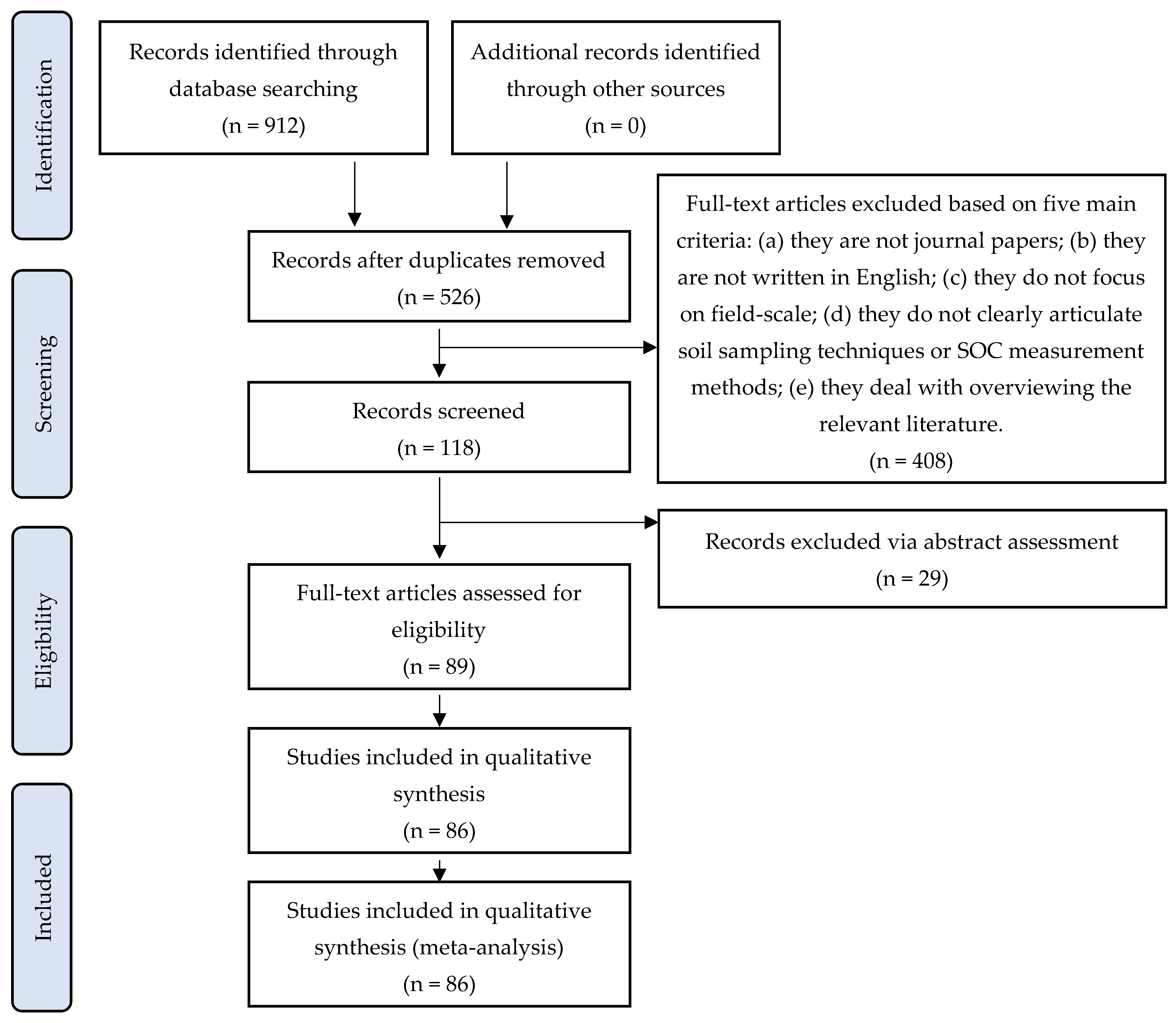
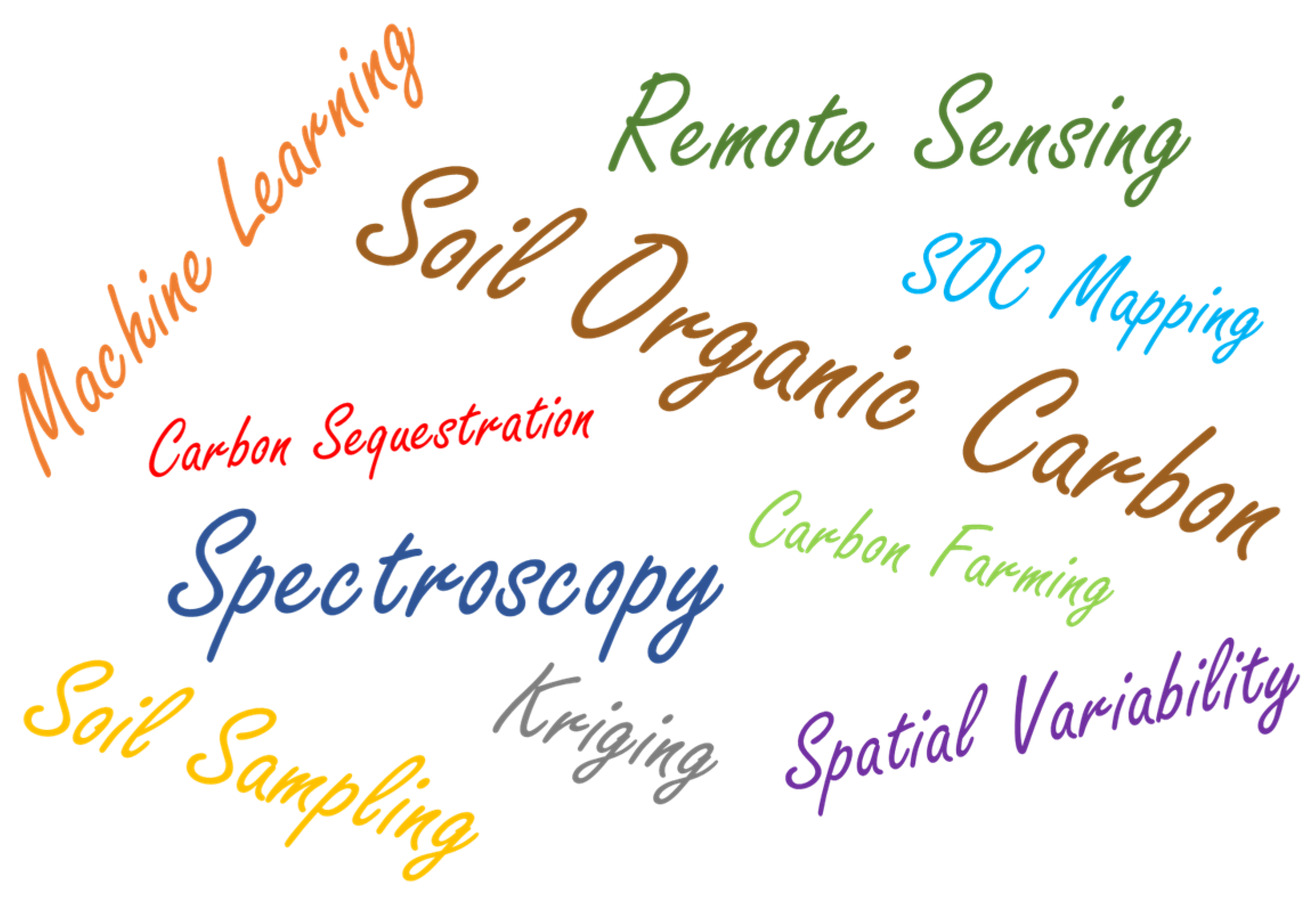


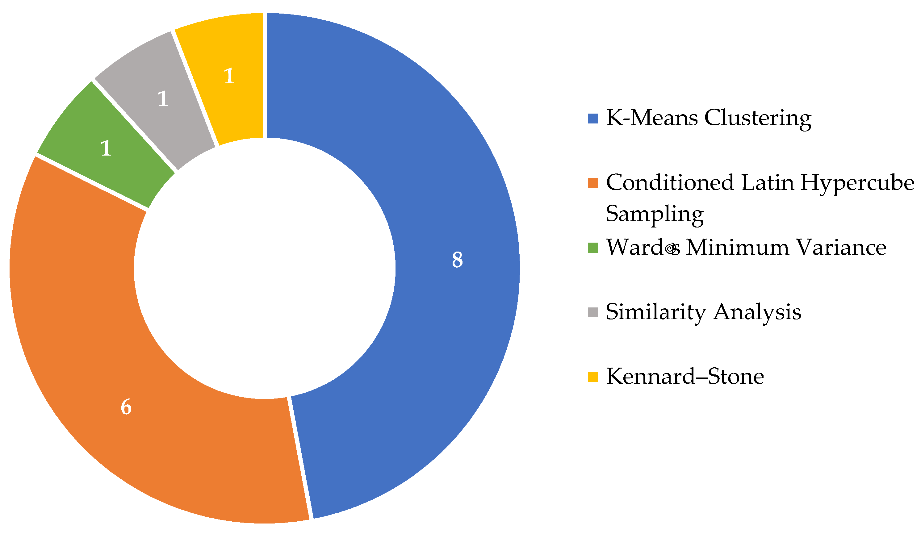
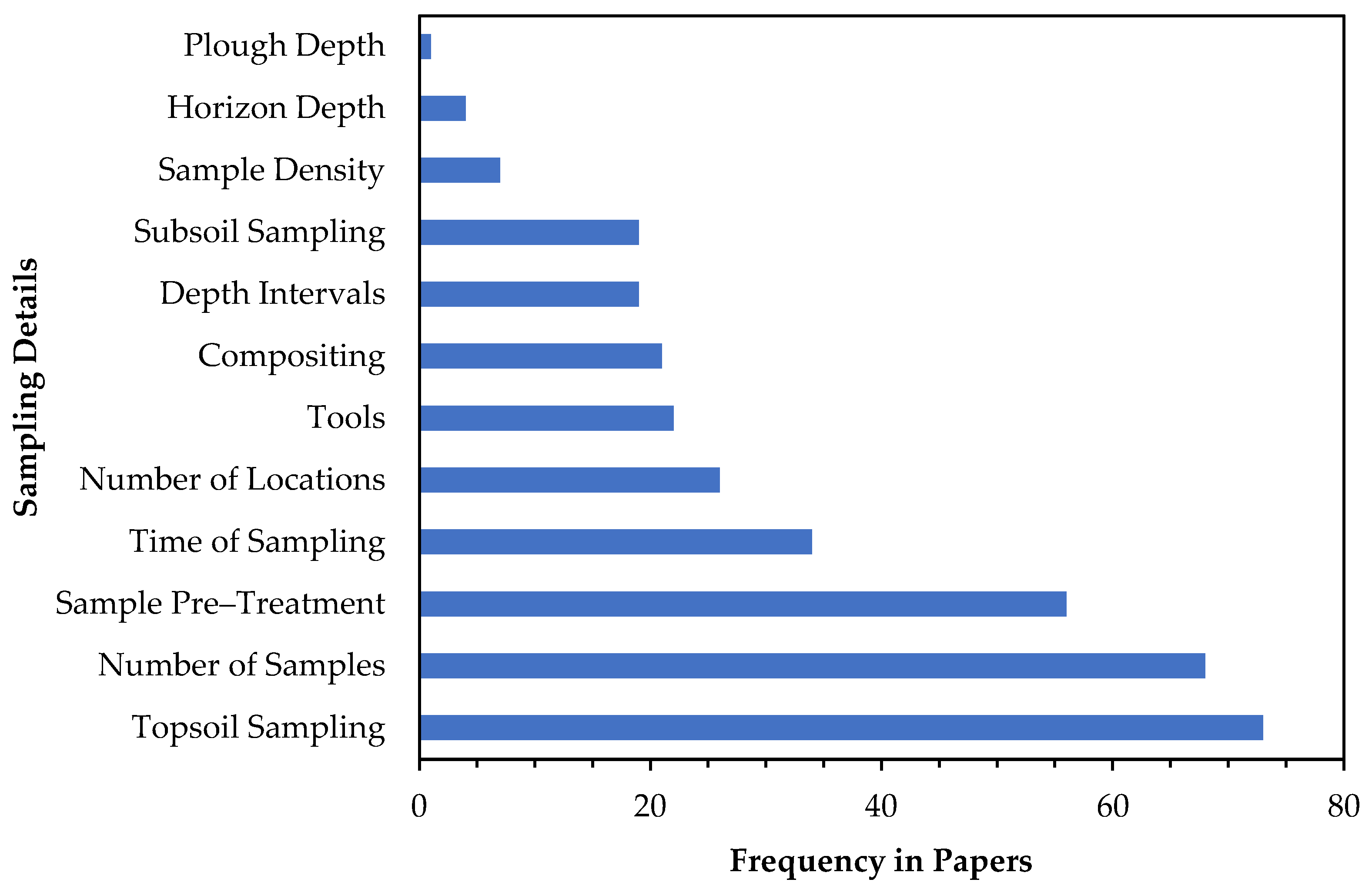
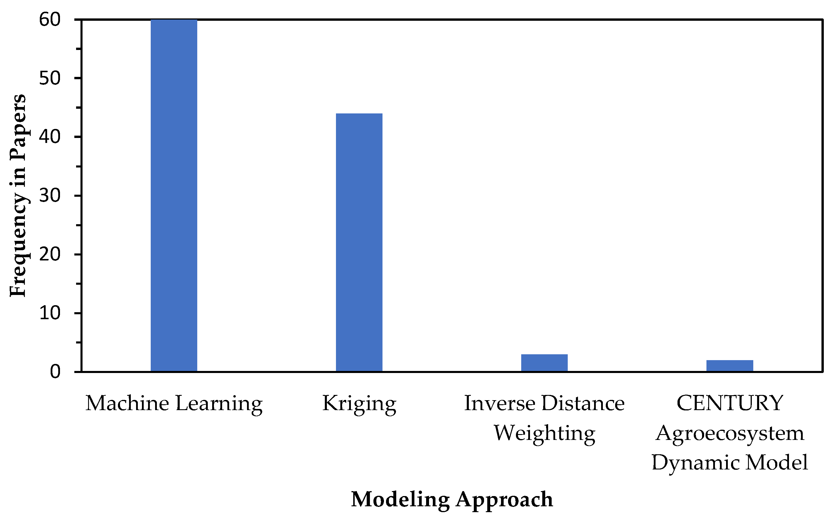
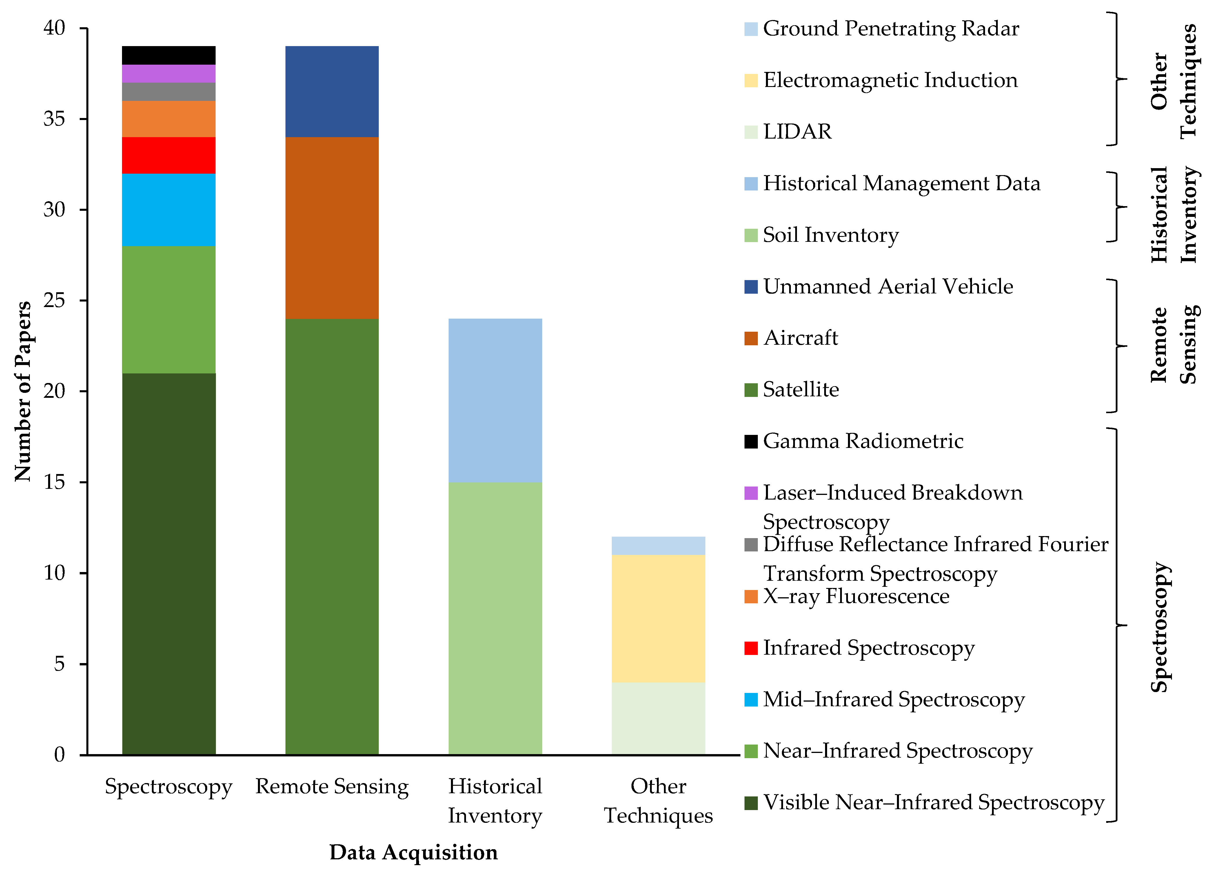

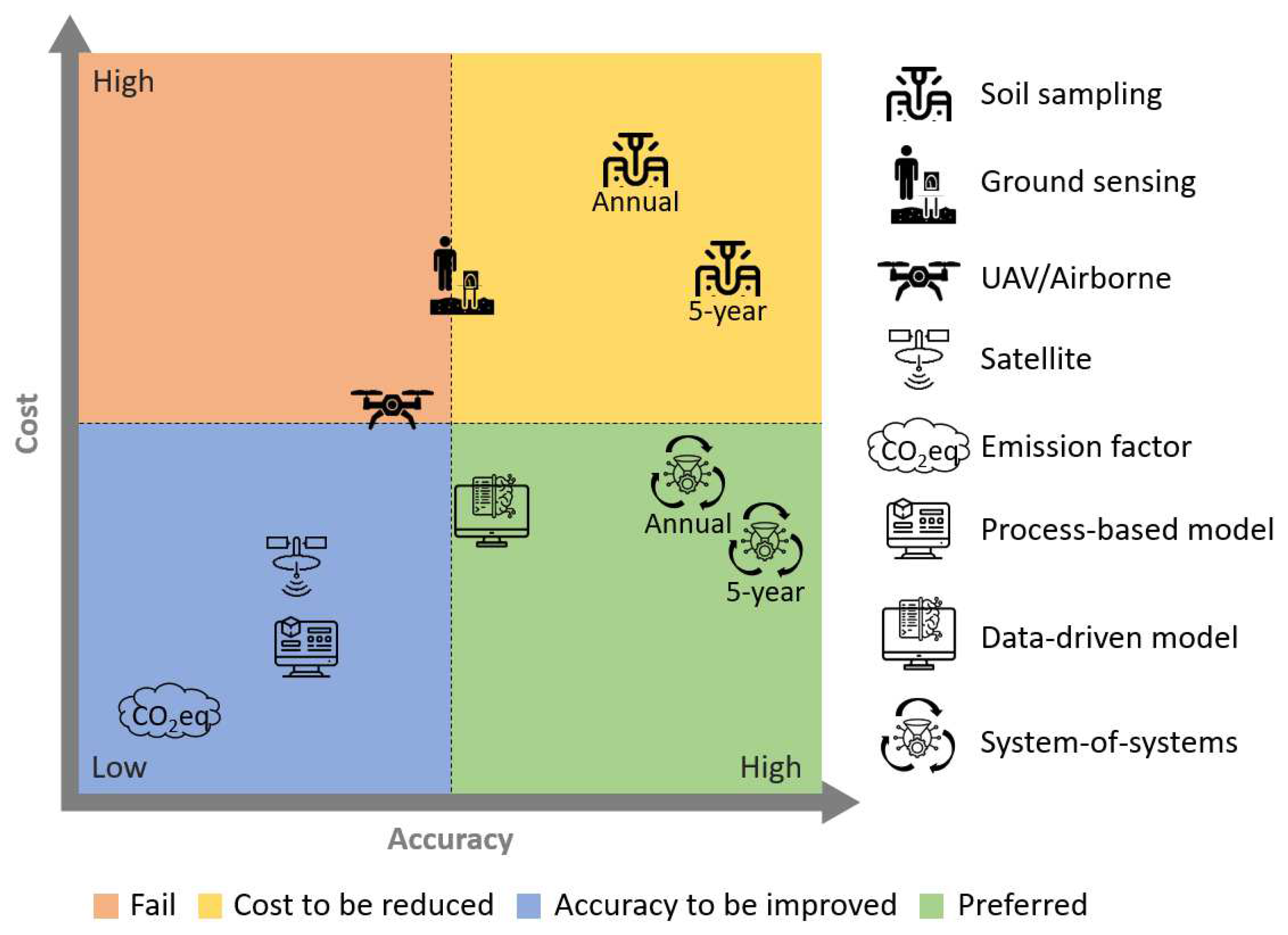
Disclaimer/Publisher’s Note: The statements, opinions and data contained in all publications are solely those of the individual author(s) and contributor(s) and not of MDPI and/or the editor(s). MDPI and/or the editor(s) disclaim responsibility for any injury to people or property resulting from any ideas, methods, instructions or products referred to in the content. |
© 2025 by the authors. Licensee MDPI, Basel, Switzerland. This article is an open access article distributed under the terms and conditions of the Creative Commons Attribution (CC BY) license (https://creativecommons.org/licenses/by/4.0/).