Monitoring Agricultural Expansion in a Newly Reclaimed Area in the Western Nile Delta of Egypt Using Landsat Imageries


Abstract

1. Introduction
2. Materials and Methods
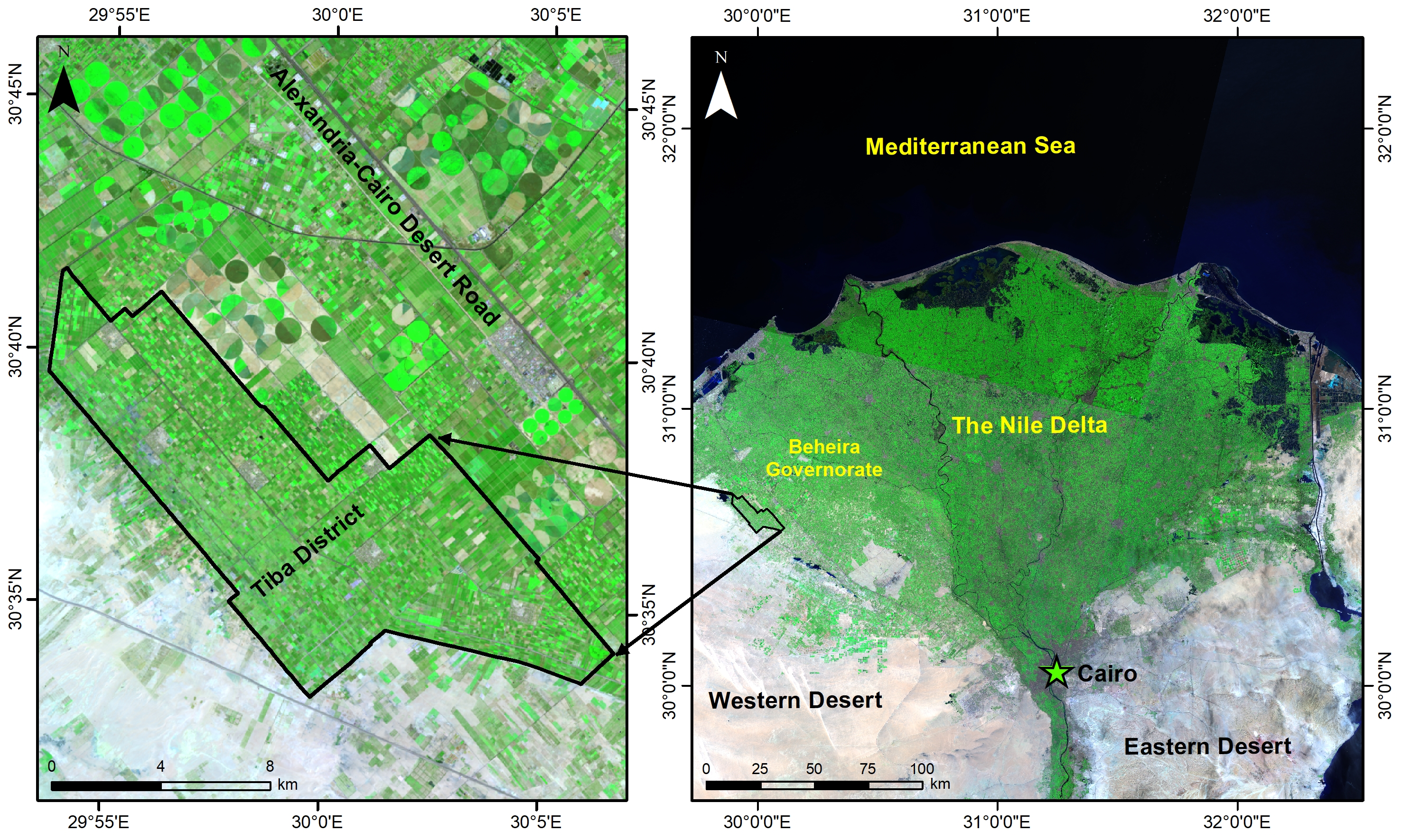
2.1. Study Area
2.2. Data sets Collection and Description
2.2.1. Landsat Imageries Description
2.2.2. Ancillary and Other Data Description
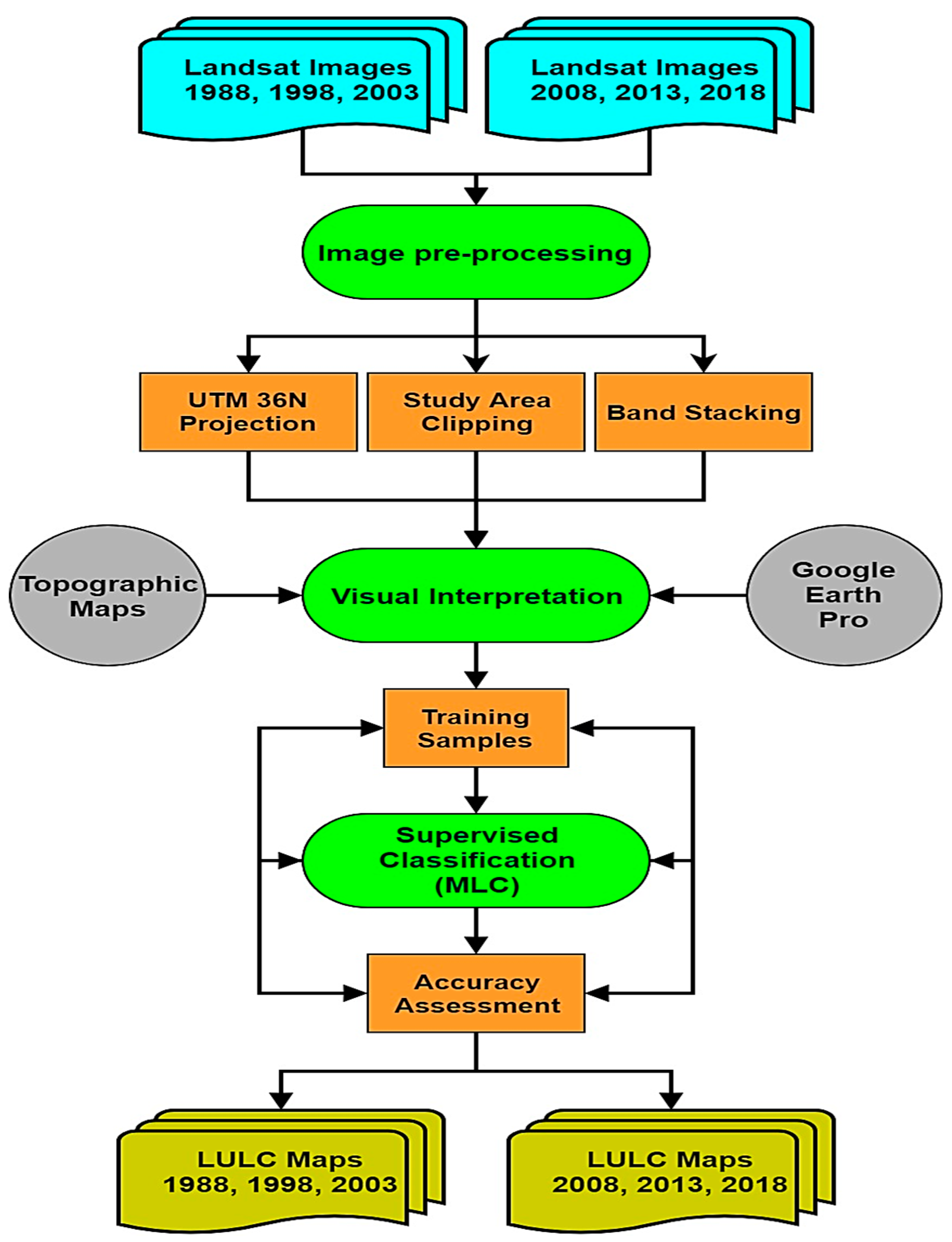
2.3. Satellite Image Pre-Processing
2.4. Images Visual Interpretation
2.5. Supervised Image Classification
2.6. Classification Accuracy Assessment
3. Results
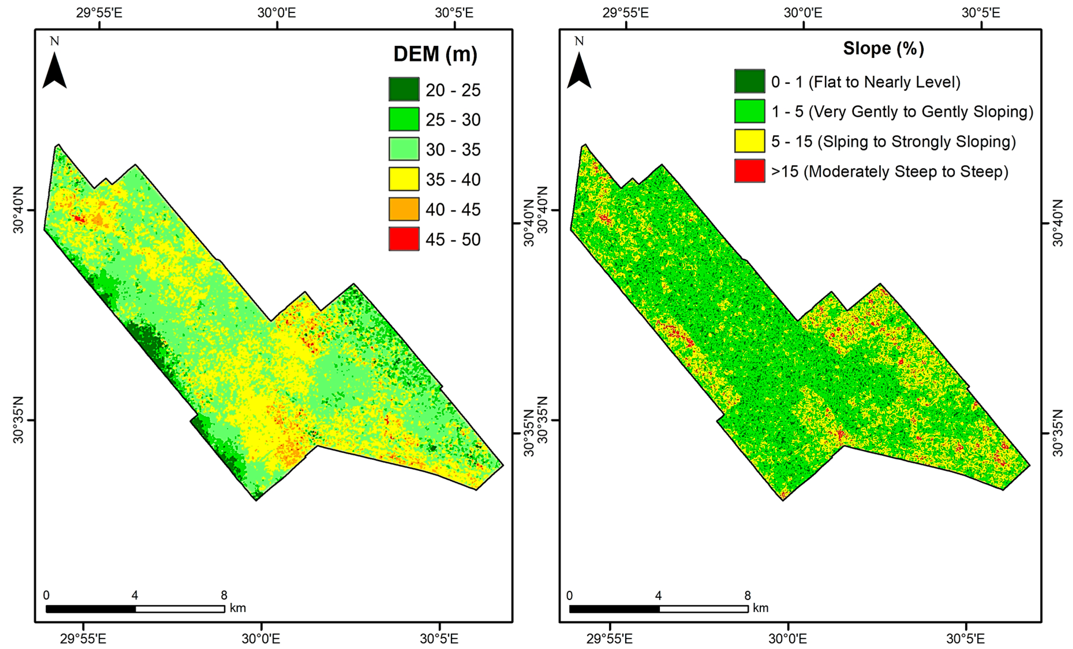
3.1. SRTM DEM and Slope Analysis
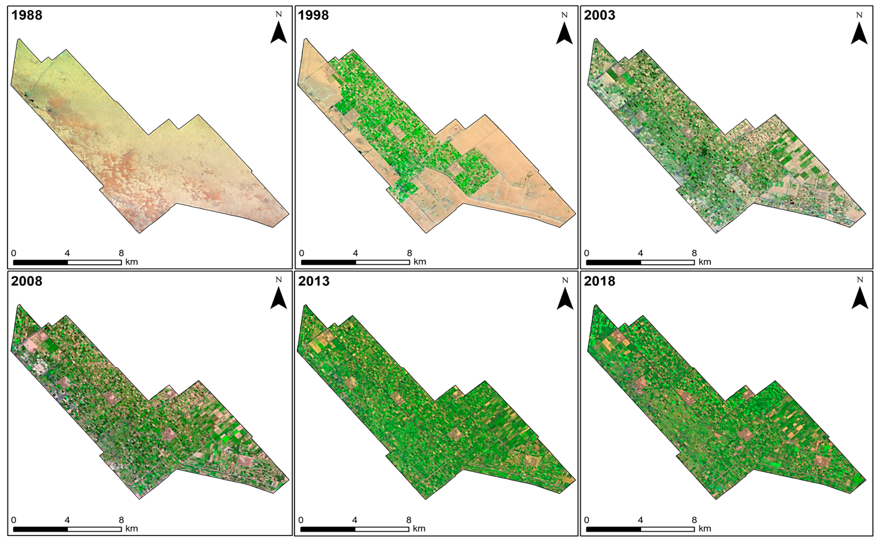
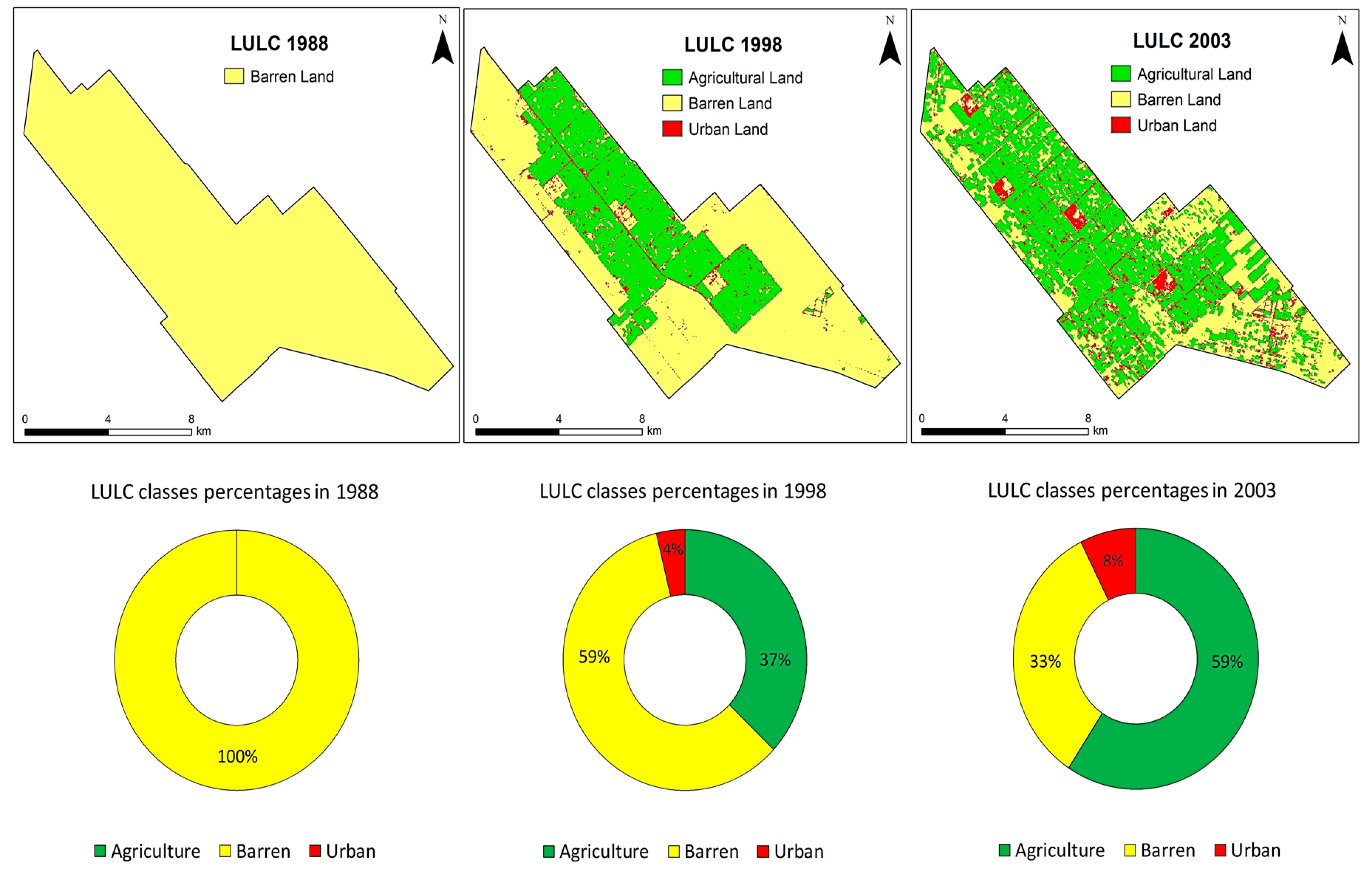
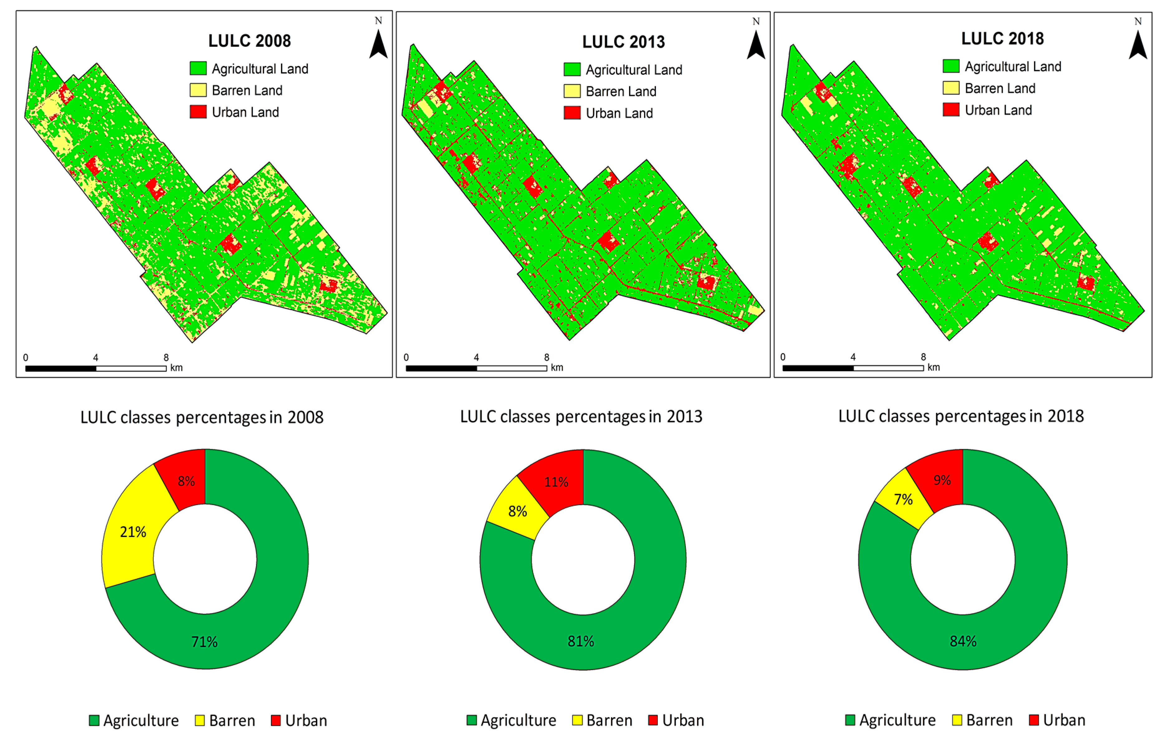
3.2. Temporal LULC Change Analysis
3.3. Classification Accuracy Validation
4. Discussion
5. Conclusions
Author Contributions
Acknowledgments
Conflicts of Interest
References
- Worldometers. Available online: http://www.worldometers.info/world-population/egypt-population/ (accessed on 13 May 2019).
- CAPMAS. The Central Agency for Public Mobilization and Statistics. The Arab Republic of Egypt. 2019. Available online: http://www.capmas.gov.eg/ (accessed on 15 May 2019).
- Bakr, N.; Bahnassy, M.H. Egyptian Natural Resources. In The Soils of Egypt; El-Ramady, H., Alshaal, T., Bakr, N., Elbana, T., Mohamed, E., Belal, A.A., Eds.; World Soils Book Series; Springer: Cham, Switzerland, 2019; pp. 33–49. [Google Scholar]
- Shalaby, A.; Tateishi, R. Remote sensing and GIS for mapping and monitoring land cover and land-use changes in the Northwestern coastal zone of Egypt. Appl. Geogr. 2007, 27, 28–41. [Google Scholar] [CrossRef]
- Abd El-Kawy, O.R.; Rød, J.K.; Ismail, H.A.; Suliman, A.S. Land use and land cover change detection in the western Nile delta of Egypt using remote sensing data. Appl. Geogr. 2011, 31, 483–494. [Google Scholar] [CrossRef]
- Radwan, T.M.; Blackburn, G.A.; Whyatt, J.D.; Atkinson, P.M. Dramatic Loss of Agricultural Land Due to Urban Expansion Threatens Food Security in the Nile Delta, Egypt. Remote Sens. 2019, 11, 332. [Google Scholar] [CrossRef]
- Liu, F.; Zhang, Z.; Zhao, X.; Wang, X.; Zuo, L.; Wen, Q.; Yi, L.; Xu, J.; Hu, S.; Liu, B. Chinese cropland losses due to urban expansion in the past four decades. Sci. Total Environ. 2019, 650, 847–857. [Google Scholar] [CrossRef] [PubMed]
- Bratley, K.; Ghoneim, E. Modeling Urban Encroachment on the Agricultural Land of the Eastern Nile Delta Using Remote Sensing and a GIS-Based Markov Chain Model. Land 2018, 7, 114. [Google Scholar] [CrossRef]
- Pax-Lenney, M.; Woodcock, C.E.; Collins, J.B.; Hamdi, H. The status of agricultural lands in Egypt: The use of multitemporal NDVI features derived from Landsat TM. Remote Sens. Environ. 1996, 56, 8–20. [Google Scholar] [CrossRef]
- Adriansen, H.K. Land reclamation in Egypt: A study of life in the new lands. Geoforum 2009, 40, 664–674. [Google Scholar] [CrossRef]
- Bakr, N.; Weindorf, D.C.; Bahnassy, M.H.; Marei, S.M.; El-Badawi, M.M. Monitoring land cover changes in a newly reclaimed area of Egypt using multi-temporal Landsat data. Appl. Geogr. 2010, 30, 592–605. [Google Scholar] [CrossRef]
- Rural Poverty Report 2011. New Realities, New Challenges: New Opportunities for Tomorrow’s Generation; International Fund for Agricultural Development (IFAD): Rome, Italy, 2010; Available online: http://www.fao.org/fileadmin/user_upload/rome2007/docs/IFAD%20Rural%20Poverty%20Report%202011.pdf (accessed on 16 May 2019).
- Basnet, B.; Vodacek, A. Tracking land use/land cover dynamics in cloud prone areas using moderate resolution satellite data: A case study in Central Africa. Remote Sens. 2015, 7, 6683–6709. [Google Scholar] [CrossRef]
- Knauer, K.; Gessner, U.; Fensholt, R.; Forkuor, G.; Kuenzer, C. Monitoring agricultural expansion in Burkina Faso over 14 years with 30 m resolution time series: The role of population growth and implications for the environment. Remote Sens. 2017, 9, 132. [Google Scholar] [CrossRef]
- Zhao, Y.; Feng, D.; Yu, L.; Cheng, Y.; Zhang, M.; Liu, X.; Xu, Y.; Fang, L.; Zhu, Z.; Gong, P. Long-Term Land Cover Dynamics (1986–2016) of Northeast China Derived from a Multi-Temporal Landsat Archive. Remote Sens. 2019, 11, 599. [Google Scholar] [CrossRef]
- Yang, R.; Luo, Y.; Yang, K.; Hong, L.; Zhou, X. Analysis of Forest Deforestation and its Driving Factors in Myanmar from 1988 to 2017. Sustainability 2019, 11, 3047. [Google Scholar] [CrossRef]
- Dewan, A.M.; Yamaguchi, Y. Land use and land cover change in Greater Dhaka, Bangladesh: Using remote sensing to promote sustainable urbanization. Appl. Geogr. 2009, 29, 390–401. [Google Scholar] [CrossRef]
- Rahman, M.T. Detection of land use/land cover changes and urban sprawl in Al-Khobar, Saudi Arabia: An analysis of multi-temporal remote sensing data. Int. J. Geo Inf. 2016, 5, 15. [Google Scholar] [CrossRef]
- Lambin, E.F.; Turner, B.L.; Geist, H.J.; Agbola, S.B.; Angelsen, A.; Bruce, J.W.; Coomes, O.T.; Dirzo, R.; Fischer, G.; Folke, C.; et al. The causes of land-use and land-cover change: Moving beyond the myths. Glob. Environ. Chang. 2001, 11, 261–269. [Google Scholar] [CrossRef]
- Wu, Y.; Li, S.; Yu, S. Monitoring urban expansion and its effects on land use and land cover changes in Guangzhou city, China. Environ. Monit. Assess. 2016, 188, 1–15. [Google Scholar] [CrossRef] [PubMed]
- Guan, D.; Li, H.; Inohae, T.; Su, W.; Nagaie, T.; Hokao, K. Modeling urban land use change by the integration of cellular automaton and Markov model. Ecol. Model. 2011, 222, 3761–3772. [Google Scholar] [CrossRef]
- Were, K.O.; Dick, O.B.; Singh, B.R. Remotely sensing the spatial and temporal land cover changes in Eastern Mau forest reserve and Lake Nakuru drainage basin, Kenya. Appl. Geogr. 2013, 41, 75–86. [Google Scholar] [CrossRef]
- Wu, Q.; Li, H.Q.; Wang, R.S.; Paulussen, J.; He, Y.; Wang, M.; Wang, B.H.; Wang, Z. Monitoring and predicting land use change in Beijing using remote sensing and GIS. Landsc. Urban Plan. 2006, 78, 322–333. [Google Scholar] [CrossRef]
- Rogan, J.; Chen, D.M. Remote sensing technology for mapping and monitoring land-cover and land-use change. Prog. Plan. 2004, 61, 301–325. [Google Scholar] [CrossRef]
- Lu, D.; Mausel, P.; Brondizio, E.; Moran, E. Change detection techniques. Int. J. Remote Sens. 2004, 25, 2365–2407. [Google Scholar] [CrossRef]
- Pelorosso, R.; Leone, A.; Boccia, L. Land cover and land use change in the Italian central Apennines: A comparison of assessment methods. Appl. Geogr. 2009, 29, 35–48. [Google Scholar] [CrossRef]
- Singh, A. Digital change detection techniques using remotely-sensed data. Int. J. Remote Sens. 1989, 10, 989–1003. [Google Scholar] [CrossRef]
- Chen, X.; Vierling, L.; Deering, D. A simple and effective radiometric correction method to improve landscape change detection across sensors and across time. Remote Sens. Environ. 2005, 98, 63–79. [Google Scholar] [CrossRef]
- Lillesand, T.M.; Kiefer, R.W.; Chipman, J.W. Remote Sensing and Image Interpretation, 7th ed.; John Wiley & Sons: New York, NY, USA, 2015. [Google Scholar]
- Wulder, M.A.; White, J.C.; Goward, S.N.; Masek, J.G.; Irons, J.R.; Herold, M.; Cohen, W.B.; Loveland, T.R.; Woodcock, C.E. Landsat continuity: Issues and opportunities for land cover monitoring. Remote Sens. Environ. 2008, 112, 955–969. [Google Scholar] [CrossRef]
- Allam, M.; Bakr, N.; Elbably, W. Multi-temporal assessment of land use/land cover change in arid region based on Landsat satellite imagery: Case study in Fayoum Region, Egypt. Remote Sens. Appl. Soc. Environ. 2019, 14, 8–19. [Google Scholar] [CrossRef]
- Bakr, N.; Afifi, A.A. Quantifying land use/land cover change and its potential impact on rice production in the Northern Nile Delta, Egypt. Remote Sens. Appl. Soc. Environ. 2019, 13, 348–360. [Google Scholar] [CrossRef]
- Xu, Y.; Yu, L.; Zhao, Y.; Feng, D.; Cheng, Y.; Cai, X.; Gong, P. Monitoring cropland changes along the Nile River in Egypt over past three decades (1984–2015) using remote sensing. Int. J. Remote Sens. 2017, 38, 4459–4480. [Google Scholar] [CrossRef]
- Megahed, Y.; Cabral, P.; Silva, J.; Caetano, M. Land Cover Mapping Analysis and Urban Growth Modelling Using Remote Sensing Techniques in Greater Cairo Region-Egypt. ISPRS Int. J. Geo-Inf. 2015, 4, 1750–1769. [Google Scholar] [CrossRef]
- Halmy, M.W.A.; Gessler, P.E.; Hicke, J.A.; Salem, B.B. Land use/land cover change detection and prediction in the north-western coastal desert of Egypt using Markov-CA. Appl. Geogr. 2015, 63, 101–112. [Google Scholar] [CrossRef]
- Shalaby, A.; Moghanm, F.S. Assessment of urban sprawl on agricultural soil of northern Nile Delta of Egypt using RS and GIS. Chin. Geogr. Sci. 2015, 25, 274–282. [Google Scholar] [CrossRef]
- Hegazy, I.R.; Kaloop, M.R. Monitoring urban growth and land use change detection with GIS and remote sensing techniques in Daqahlia governorate Egypt. Int. J. Sustain. Built Environ. 2015, 4, 117–124. [Google Scholar] [CrossRef]
- Shalaby, A.A.; Ali, R.R.; Gad, A. Urban sprawl impact assessment on the agricultural land in Egypt using remote sensing and GIS: A case study, Qalubiya Governorate. J. Land Use Sci. 2012, 7, 261–273. [Google Scholar] [CrossRef]
- Belal, A.A. Detecting urban growth using remote sensing and GIS techniques in Al Gharbiya governorate, Egypt. Egypt. J. Remote Sens. Space Sci. 2011, 14, 73–79. [Google Scholar] [CrossRef]
- Abdulaziz, A.M.; Hurtado, J.M.; Al-Douri, R. Application of multitemporal Landsat data to monitor land cover changes in the Eastern Nile Delta region, Egypt. Int. J. Remote Sens. 2009, 30, 2977–2996. [Google Scholar] [CrossRef]
- FAO. CLIMWAT for CROPWAT: A Climatic Database for Irrigation Planning and Management; FAO Irrigation and Drainage Paper 49; FAO: Rome, Italy, 1993. [Google Scholar]
- Soil Survey Staff. Keys to Soil Taxonomy, 12th ed.; USDA-Natural Resources Conservation Service: Washington, DC, USA, 2014.
- Environmental Systems Research Institute. ArcGIS Desktop 10.5; ESRI: Redlands, CA, USA, 2016. [Google Scholar]
- Exelis Visual Information Solutions. The Environment for Visualizing Images; ENVI 5.3; Exelis Visual Information Solutions: Boulder, CO, USA, 2015. [Google Scholar]
- Coppin, P.; Jonckheere, I.; Nackaerts, K.; Muys, B.; Lambin, E. Digital change detection methods in ecosystem monitoring: A review. Int. J. Remote Sens. 2004, 25, 1565–1596. [Google Scholar] [CrossRef]
- Song, C.; Woodcock, C.E.; Seto, K.C.; Pax Lenney, M.; Macomber, S.A. Classification and change detection using Landsat TM data: When and how to correct atmospheric effects? Remote Sens. Environ. 2001, 75, 230–244. [Google Scholar] [CrossRef]
- Gao, J.; Liu, Y. Determination of land degradation causes in Tongyu County, Northeast China via land cover change detection. Int. J. Appl. Earth Observ. Geoinf. 2010, 12, 9–16. [Google Scholar] [CrossRef]
- Thapa, R.B.; Murayama, Y. Urban mapping, accuracy, and image classification: A comparison of multiple approaches in Tsukuba city, Japan. Appl. Geogr. 2009, 29, 135–144. [Google Scholar] [CrossRef]
- Richards, J.A. Remote Sensing Digital Image Analysis: An Introduction, 5th ed.; Springer-Verlag: Heidelberg/Berlin, Germany, 2013. [Google Scholar]
- Jensen, J.R. Introductory Digital Image Processing: A Remote Sensing Perspective, 4th ed.; Prentice Hall Press: Upper Saddle River, NJ, USA, 2015. [Google Scholar]
- Campbell, J.B.; Wynne, R.H. Introduction to Remote Sensing, 5th ed.; The Guilford Press: New York, NY, USA, 2011. [Google Scholar]
- Congalton, R.G. A review of assessing the accuracy of classifications of remotely sensed data. Remote Sens. Environ. 1991, 37, 35–46. [Google Scholar] [CrossRef]
- Foody, G.M. Status of land cover classification accuracy assessment. Remote Sens. Environ. 2002, 80, 185–201. [Google Scholar] [CrossRef]
- Story, M.; Congalton, R.G. Accuracy assessment: A user’s perspective. Photogramm. Eng. Remote Sens. 1986, 52, 397–399. [Google Scholar]
- FAO. Guidelines for Soil Description, 4th ed.; Food and Agriculture Organization of the United Nations: Rome, Italy, 2006. [Google Scholar]
- Anderson, J.R.; Hardy, E.E.; Roach, J.T.; Witmer, R.E. A Land Use and Land Cover Classification System for Use with Remote Sensor Data; Geological Survey Professional Paper; US Government Printing Office: Washington, DC, USA, 1976; Volume 964.
- Manandhar, R.; Odeh, I.O.A.; Ancev, T. Improving the Accuracy of Land Use and Land Cover Classification of Landsat Data Using Post-Classification Enhancement. Remote Sens. 2009, 1, 330–344. [Google Scholar] [CrossRef]
- Afifi, A.A.; Darwish, K.M. Detection and impact of land encroachment in El-Beheira governorate, Egypt. Model. Earth Syst. Environ. 2018, 4, 517–526. [Google Scholar] [CrossRef]


| Satellite/Sensor | Spatial Resolution | Acquisition Date |
|---|---|---|
| Landsat-5 (TM) | 30 m | 07/1988 |
| Landsat-5 (TM) | 30 m | 07/1998 |
| Landsat-7 (ETM+) | 30 m | 05/2003 |
| Landsat-5 (TM) | 30 m | 05/2008 |
| Landsat-8 (OLI) | 30 m | 07/2013 |
| Landsat-8 (OLI) | 30 m | 05/2018 |
| LULC Class Year | Agriculture | Barren | Urban | |||
|---|---|---|---|---|---|---|
| Hectares | (%) | Hectares | (%) | Hectares | (%) | |
| 1988 | 0.00 | 0.00 | 12,527 | 100.00 | 0.00 | 0.00 |
| 1998 | 4640 | 37.04 | 7413 | 59.18 | 474 | 3.78 |
| 2003 | 7421 | 59.24 | 4179 | 33.36 | 927 | 7.40 |
| 2008 | 8860 | 70.73 | 2625 | 20.95 | 1042 | 8.32 |
| 2013 | 10,111 | 80.71 | 1021 | 8.15 | 1395 | 11.14 |
| 2018 | 10,510 | 83.90 | 855 | 6.82 | 1162 | 9.28 |
| Net change (1998–2018) | 5870 | 126.51 | −6558 | −88.47 | 688 | 145.15 |
| Landsat Scene | LULC Type | Reference Data | User’s Accuracy | Overall Accuracy | Kappa (K^) | |||
|---|---|---|---|---|---|---|---|---|
| Agriculture | Barren | Urban | ||||||
| 1998 | 93.00% | 0.88 | ||||||
| Classified data | Agriculture | 32 | 2 | 0 | 34 | 94.12% | ||
| Barren | 2 | 49 | 1 | 52 | 94.23% | |||
| Urban | 0 | 2 | 12 | 14 | 85.71% | |||
| Reference total | 34 | 53 | 13 | 100 | ||||
| Producer’s accuracy | 94.12% | 92.45% | 92.31% | |||||
| 2003 | 92.00% | 0.87 | ||||||
| Classified data | Agriculture | 44 | 2 | 2 | 48 | 93.75% | ||
| Barren | 1 | 31 | 2 | 34 | 94.12% | |||
| Urban | 1 | 0 | 17 | 18 | 94.40% | |||
| Reference total | 46 | 33 | 21 | 100 | ||||
| Producer’s accuracy | 95.65% | 93.93% | 80.95% | |||||
| 2008 | 95.00% | 0.92 | ||||||
| Classified data | Agriculture | 54 | 1 | 1 | 56 | 96.43% | ||
| Barren | 1 | 22 | 1 | 24 | 91.60% | |||
| Urban | 1 | 0 | 19 | 20 | 95.00% | |||
| Reference total | 56 | 23 | 21 | 100 | ||||
| Producer’s accuracy | 96.43% | 95.65% | 90.48% | |||||
| 2013 | 94.00% | 0.88 | ||||||
| Classified data | Agriculture | 63 | 2 | 1 | 66 | 95.45% | ||
| Barren | 1 | 10 | 1 | 12 | 83.30% | |||
| Urban | 1 | 0 | 21 | 22 | 95.45% | |||
| Reference total | 65 | 12 | 23 | 100 | ||||
| Producer’s accuracy | 96.92% | 83.30% | 91.30% | |||||
| 2018 | 93.00% | 0.86 | ||||||
| Classified data | Agriculture | 64 | 2 | 2 | 68 | 94.12% | ||
| Barren | 1 | 11 | 0 | 12 | 91.60% | |||
| Urban | 2 | 0 | 18 | 20 | 90.00% | |||
| Reference total | 67 | 13 | 20 | 100 | ||||
| Producer’s accuracy | 95.52% | 84.62% | 90.00% | |||||
© 2019 by the author. Licensee MDPI, Basel, Switzerland. This article is an open access article distributed under the terms and conditions of the Creative Commons Attribution (CC BY) license (http://creativecommons.org/licenses/by/4.0/).
Share and Cite
Radwan, T.M. Monitoring Agricultural Expansion in a Newly Reclaimed Area in the Western Nile Delta of Egypt Using Landsat Imageries. Agriculture 2019, 9, 137. https://doi.org/10.3390/agriculture9070137
Radwan TM. Monitoring Agricultural Expansion in a Newly Reclaimed Area in the Western Nile Delta of Egypt Using Landsat Imageries. Agriculture. 2019; 9(7):137. https://doi.org/10.3390/agriculture9070137
Chicago/Turabian StyleRadwan, Taher M. 2019. "Monitoring Agricultural Expansion in a Newly Reclaimed Area in the Western Nile Delta of Egypt Using Landsat Imageries" Agriculture 9, no. 7: 137. https://doi.org/10.3390/agriculture9070137
APA StyleRadwan, T. M. (2019). Monitoring Agricultural Expansion in a Newly Reclaimed Area in the Western Nile Delta of Egypt Using Landsat Imageries. Agriculture, 9(7), 137. https://doi.org/10.3390/agriculture9070137