Article

Structure and Evolution of Multi-Trend Faults in BZ19-6 Buried Hill of the Bohai Bay Basin, Eastern China

by
Rui Lou
1,2,
Yonghe Sun
1,2,*,
Fujie Jiang
3,
Yumin Liu
4 and
Tian Gao
5
1
School of Petroleum Engineering, Chongqing University of Science and Technology, Chongqing 401331, China
2
Chongqing Key Laboratory of Complex Oil & Gas Field Exploration and Development, Chongqing 401331, China
3
College of Geosciences, China University of Petroleum, Beijing 102200, China
4
School of Electronic and Electrical Engineering, Chongqing University of Science and Technology, Chongqing 401331, China
5
Research Institute of Exploration and Development, PetroChina Liaohe Oilfield Company, Panjin 124010, China
*
Author to whom correspondence should be addressed.
J. Mar. Sci. Eng. 2024, 12(10), 1727; https://doi.org/10.3390/jmse12101727
Submission received: 12 August 2024 / Revised: 24 September 2024 / Accepted: 24 September 2024 / Published: 1 October 2024
(This article belongs to the Section Geological Oceanography)

Abstract

:
Defining the structure and evolution of multi-trend faults is critical for analyzing the accumulation of hydrocarbons in buried hills. Based on high-resolution seismic and drilling data, the structural characteristics and evolutionary mechanism of multi-trend faults were investigated in detail through the structural analysis theory and quantitative calculations of fault activity, allowing us to determine the implication that fault evolution exerts on hydrocarbon accumulation in the BZ19-6 buried hill. There are four kinds of strike faults developed on the buried hill: SN-, NNE-, NE–ENE-, and nearly EW-trending, which experienced the Mesozoic Indosinian, Yanshan, and Cenozoic Himalayan tectonic movements. During the Indosinian, the BZ19-6 was in a SN-oriented compressional setting, with active faults composed of SN-trending strike-slip faults (west branch of the Tanlu fault zone) and near EW-trending thrust faults (Zhang-peng fault zone). During the Yanshanian, the NNE-trending normal faults were formed under the WNW–ESE tensile stress field. Since the Himalayan period, the BZ19-6 buried hill has evolved into the rifting stage. In rifting stage Ⅰ, all of the multi-trend pre-existing faults were reactivated, and the EW-trending thrust faults became normal faults due to negative inversion. In rifting stage II, a large number of NE–ENE-trending normal faults were newly formed in the NW–SE-oriented extensional setting, which made the structure pattern more complicated. In rifting stage III, the buried hill entered the post-rift stage, with only part of the NNE- and NE–ENE-trending faults continuously active. Multi-trend faults are the result of the combination of various multi-phase stress fields and pre-existing structures, which have great influence on the formation of tectonic fractures and then control the distribution of high-quality reservoirs in buried hills. The fractures controlled by the NNE- and EW-trending faults have higher density and scale, and fractures controlled by NE–ENE trending faults have stronger connectivity and effectiveness. The superposition of multi-trend faults is the favorable distribution of high-quality reservoirs and the favorable accumulation area of hydrocarbon.

1. Introduction

Following the increasing degree of oil and gas exploration, deep (3500–4500 m) and ultra-deep (>4500 m) fields have become attractive exploration targets [1,2,3]. Many large–medium-sized deep oil and gas fields have been found in several basins worldwide, such as the Gulf of Mexico Basin in the U.S. [4,5], the North Sea [6], and the West Siberian Basin [7] in Europe. In recent years, buried hills as a key area of deep and ultra-deep fields of China has made major breakthroughs, such as Renqiu [8], Xinglongtai [9], ShuLu [10,11] and Qianmiqiao [12]. Buried hills generally refer to early formed hills, where the paleotopographic highs have first experienced long-term weathering and erosion before the basin received deposition of overlying sediments [13]. Previous studies on buried-hill reservoirs mainly focused on lithology distribution and reservoir space characterization [10,14,15,16], but neglected fault is one of the important geological factors affecting the formation of the buried-hill reservoir [17,18]. Especially in areas where tectonic events occur frequently, the superposition of multiple phases of tectonic deformation will lead to the interaction between preexisting faults of different properties and newborn faults to produce complex structural patterns [19,20,21]. The interaction relationship and genetic mechanism of complex faults are unclear, which will restrict the analysis of hydrocarbon accumulation law in fault-controlled buried hills.
The BZ19-6 buried hill is located in the Bohai Bay Basin and was discovered as a giant gas field with reserves of more than 100 billion cubic meters in 2019, which has undergone the superimposed evolution of the Mesozoic Indosinian, Yanshanian, and Cenozoic Himalayan tectonic movements [22,23,24]. Therefore, the 19-6 buried hill has been influenced by multiple phases of strike-slip, compressional, and tensional stress fields, leading to a complex tectonic structure characterized by the overprinting of faults in various orientations [14,24]. In this paper, we used 3D seismic data to analyze the geometric and kinematic characteristics of the multi-trend faults in the BZ19-6 buried hill, to determine the generation time of each trending fault and its activity in different periods. On this basis, we clarified the genetic mechanism and evolutionary process of faults in the buried hill and analyzed the controlling effect of faults on hydrocarbon accumulation in the buried hill so as to guide the exploration of favorable hydrocarbon zones in buried hills.

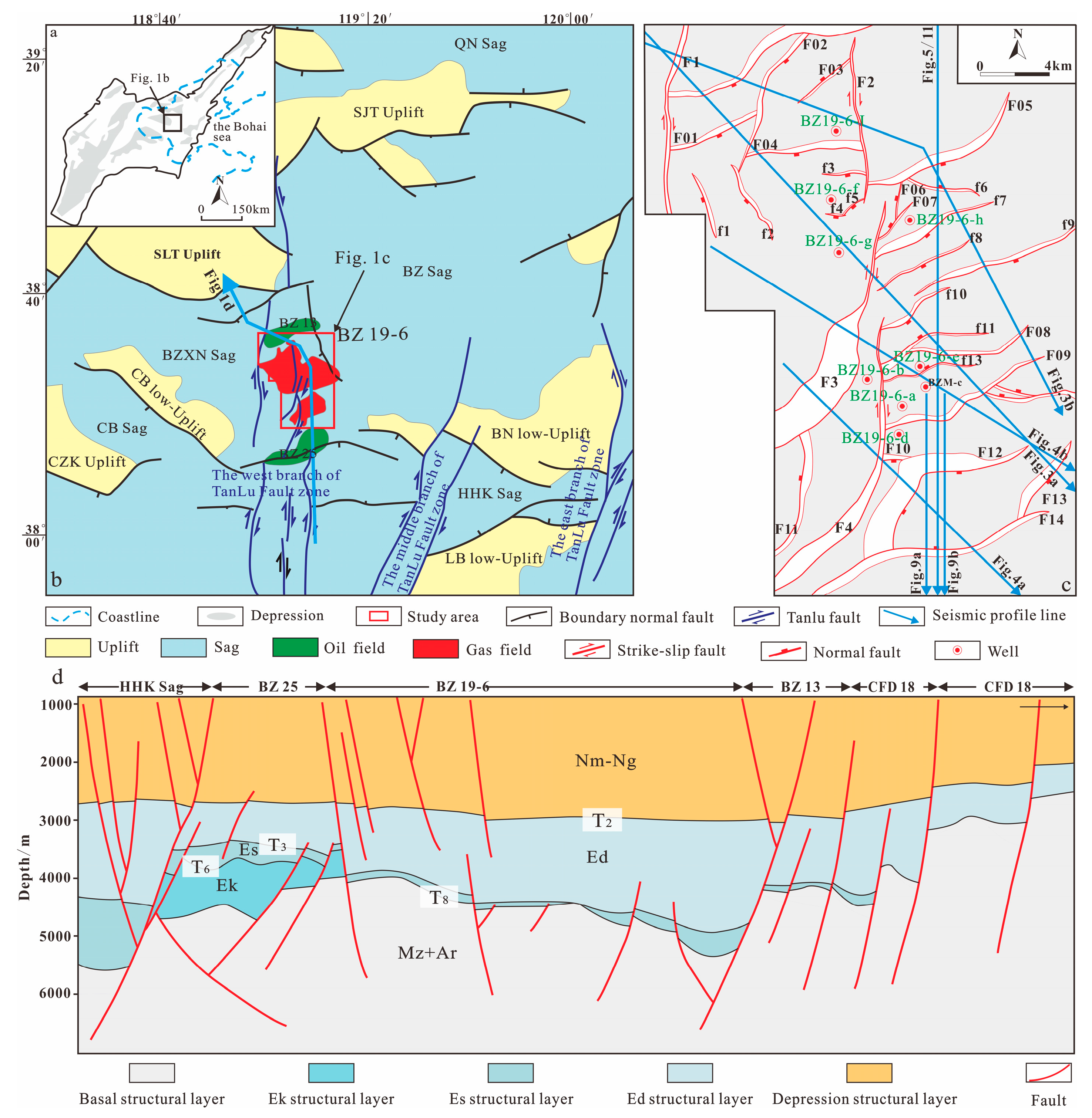
2. Geological Setting

The Bohai Bay Basin is a large Mesozoic-Cenozoic superimposed intra-cratonic fault basin developed at the eastern margin of the North China Plate, which has undergone a complex tectonic evolution due to the interaction of the Paleo-Asian Ocean, Tethys Ocean, and Pacific tectonic domains [22,24,25,26]. During the Paleozoic, the North China Paleo-continent underwent the occurrence of cratonization [24,25] and continent reconstruction [27,28], which provided the foundation for the subsequent generation of several independent tectonic units by rifting and tectonic subsidence during the Miocene. Since the initial cratonization of the North China landmass at the end of the Archean, the evolution process of the Bohai Bay Basin can be divided into two stages: (1) the stable development stage of the craton before the Mesozoic and (2) the craton cracking and destruction stage after the Mesozoic. During the craton cracking and destruction stage, it mainly experienced three tectonic movements: Mesozoic Indosinian, Yanshan, and Cenozoic Himalayan [25,27,28,29]. The Mesozoic Indosinian and Yanshan tectonic movements not only changed the physical and chemical properties of the lithosphere mantle, but also induced strong magma activity and the formation of a series of multi-strike pre-existing faults in the Bohai Bay Basin [29,30,31]. During the Himalayan tectonic movement, the Bohai Bay Basin mainly experienced the Paleogene rifting stage and the Neogene-Quaternary post-rifting stage [27,32].
The BZ19-6 buried hill, with an exploration area of about 630 km2, is located at the southwest of the Bozhong sag in the Bohai Bay Basin (Figure 1a). It is a near SN-trending anticlinal structure belt surrounded by four hydrocarbon-bearing depressions, including the Bozhong Southwest sag, Bozhong Main sag, Bozhong South sag, and Huanghekou sag (Figure 1b). The compressive stress field of the Indosinian and Yanshan tectonic movements caused the denudation after the uplift of the Paleozoic and Mesozoic, resulting in the Archeozoic basement directly emerging as the top of the buried hill [17,33]. Afterwards, along with the superposition of multiple tectonic movements, NS-trending strike-slip faults and several NNE-, NE–ENE, and EW-trending normal faults were developed at the top of the buried hill.
The buried hill is mainly composed of Archean metamorphic rocks. Above the buried hill, the sedimentary sequence changed from Mesozoic group (Mz), Kongdian Formation (Ek), Shahejie Formation (Es), Dongying Formation (Ed), Guantao Formation (Ng), and Minghuazhen Formation (Nm) to Quaternary (Qp) from bottom to top [34,35] (Figure 2). The Mesozoic is only locally developed, and the lithology is mainly volcanic rocks, mainly sedimentary volcanic rocks. The Kongdian Formation was deposited in a delta environment with a thickness of 400~700 m. The upper part of the formation is fine sandstone with gravel, and the middle and lower parts are a giant thick sand conglomerate. The Shahejie Formation is mainly deposited in the delta and lake environment, with a thin thickness of 40–170 m. The lithology is thick mudstone interspersed with thin layers of argillaceous siltstone. The Dongying Formation is mainly deposited in the lake environment, with large thickness about 580–1500 m, and can be subdivided into the Ed1 member, Ed2 member, and Ed3 member. The lithology is mainly mudstone, which can be used as a regional cover layer. Guantao and Minghuazhen formations are mainly deposited in river and delta environments. The lithology of the Guantao Formation is composed of thick sandstone and thin mudstone. The Minghuazhen Formation can be subdivided into upper and lower members. The mudstones of Ed3 and Es are high-quality source rocks with a hydrocarbon emission intensity of about 1000 × 104 t/km2, which provides a sufficient natural gas resource base for the formation of large gas fields [17,33]. The buried-hill metamorphic rock of Archean and conglomerate of Ek are high-quality reservoirs. The thick overpressure lacustrine mudstone cover in Ed provided good preservation conditions (Figure 2). Within the overlying sequences, four major unconformities were recognized with obvious onlap and downlap cutting of strata. They are named T2, T3, T6, and T8, respectively, which divided the stratigraphy vertically into five major tectonic units: the pre-Cenozoic basement, the Paleogene Kongdian Group, the Shahejie Group, the Dongying Group, and the Neogene Guantao-Minghuazhen Group depressional (Figure 1d).

3. Dataset and Method

In this study, we used high-frequency 3D seismic data reprocessed in the year of 2015, which covers an area of about 630 km2. The dominant frequency of the data varies with depth, where the effective band width of Ek and Es is 60~40 Hz, the dominant frequency is about 20 Hz, and the vertical resolution of seismic data is about 45 m. In contrast, the effective band width near the top of the buried hills is 10~30 Hz, the dominant frequency is about 15 Hz, and the vertical resolution of the seismic data is about 90 m. The spatial resolution is equivalent to a shot interval of 25 m. Based on the well-seismic tie from several types of wells, eight seismic horizons were interpreted using the Geoeast software v3.5, including T02, T0, T2, T31, T3m, T3, T6, and T8. The horizon interpretations were further used to evaluate the variation in fault throw and thickness of strata near the fault. Among all eight horizons, the T8 reflection surface is the top interface covering the buried hill. There is a strong impedance contrast above and below this surface. On the seismic data, it corresponds to a peak reflection with strong energy, strong continuity, and stable phase. Seismic reflection of the overlying strata above T8 surface has low frequency and weak amplitude, while the seismic reflection of the inner part of the buried hill were characterized as chaotic.
Nine exploration wells data were collected from the BZ19-6 buried hill (Figure 1c), which include cores, conventional logs, and image logs, to characterize the features of fractures. Firstly, fracture density is the number of fractures per unit length; it can be calculated directly from the outcrops or obtained using Terzaghi’s correction method [36,37]. Secondly, fracture occurrence (strike and dip) was determined by image logging interpretation [38,39,40]. Thirdly, the width of the fracture zone, filling characteristics, and cutting relationships of the fractures can be obtained from outcrops and cores. The conventional logs from each well include neutron, density, and sound waves. All the seismic and well data were provided by the China National Offshore Oil Corporation, Tianjin branch.
We measured the fault throws on selected seismic sections perpendicular to the local fault strike. To understand the fault evolution history and growth mechanism, throw-distance (T-x) plots [41,42], throw-depth (T-z) plots [43,44], and growth indices were made based on the measured data to determine the timing of fault generation and the intensity of faulting. The minimal values of fault throw indicate segmentation of the fault, and the growth index >1 indicates the fault is active. In this paper, the true depth is replaced by the two-way travel time (TWT) to simplify the analysis because the relationships of fault throw with the time and depth in the T-x and T-z plots are similar [45,46]. Seismic resolution is considered to be the main source of error when measuring the fault throws. The maximum error is estimated to be the seismic sampling interval of 2 ms.

4. Results and Observations

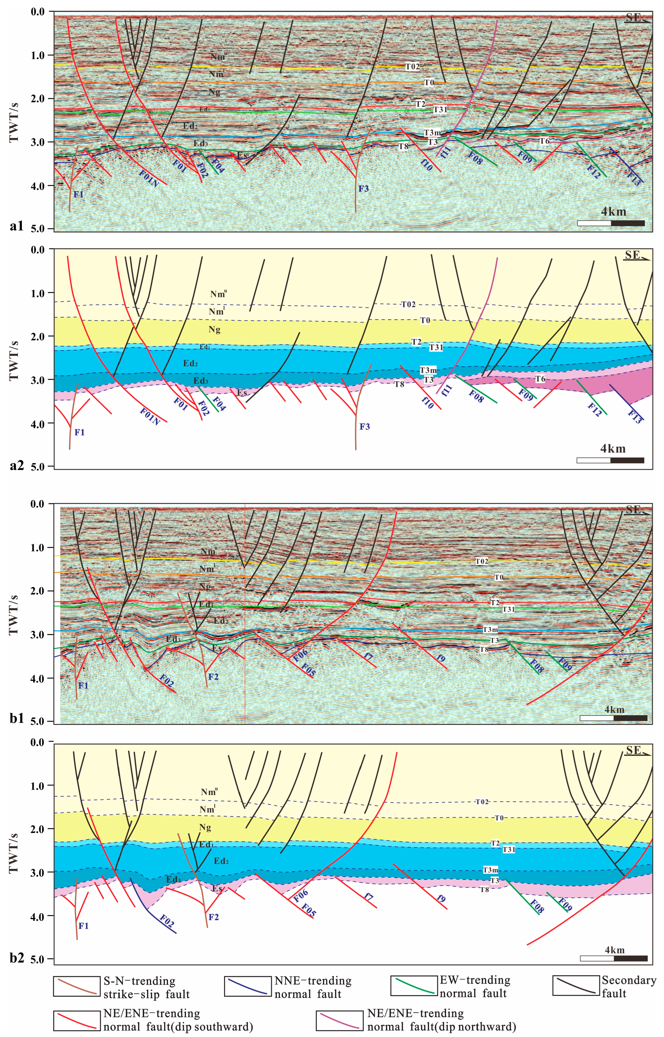
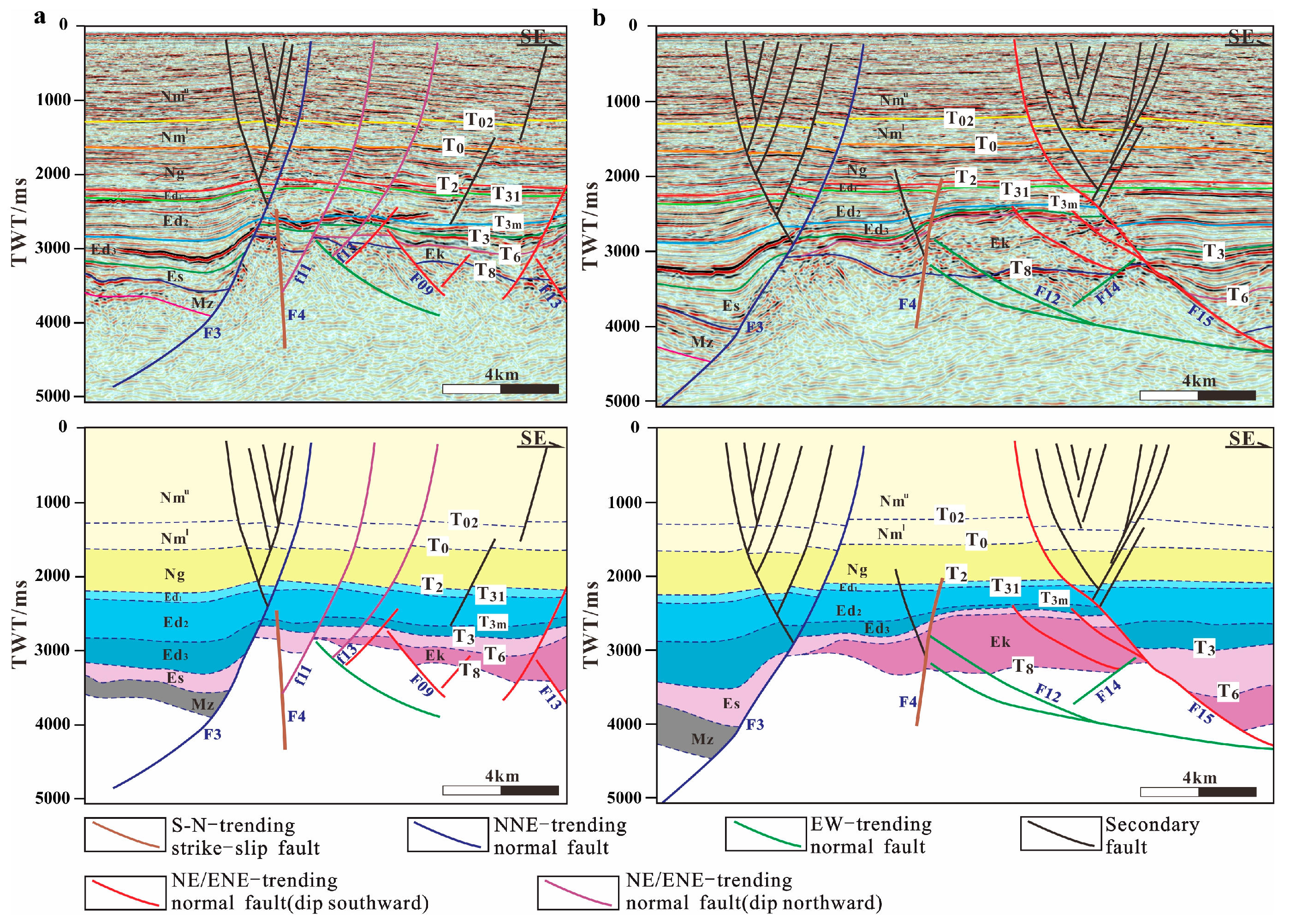
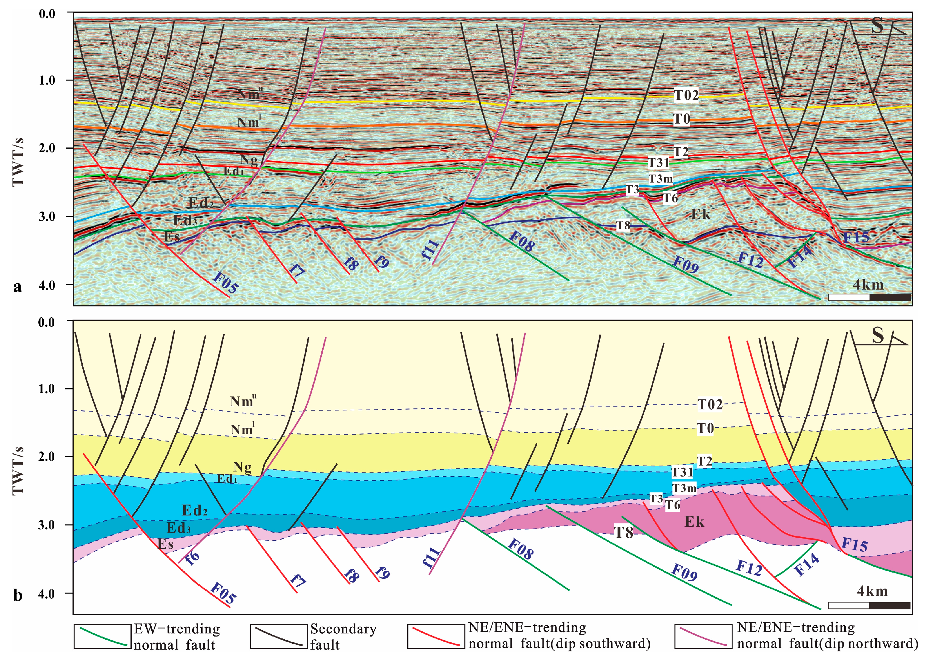
4.1. Geometric Characteristics of Multi-Trend Faults

There are four main groups of fault systems developed at the top of the BZ19-6 buried hill: NS-trending strike-slip faults and NNE-, EW-, and NE-ENE-trending normal faults.

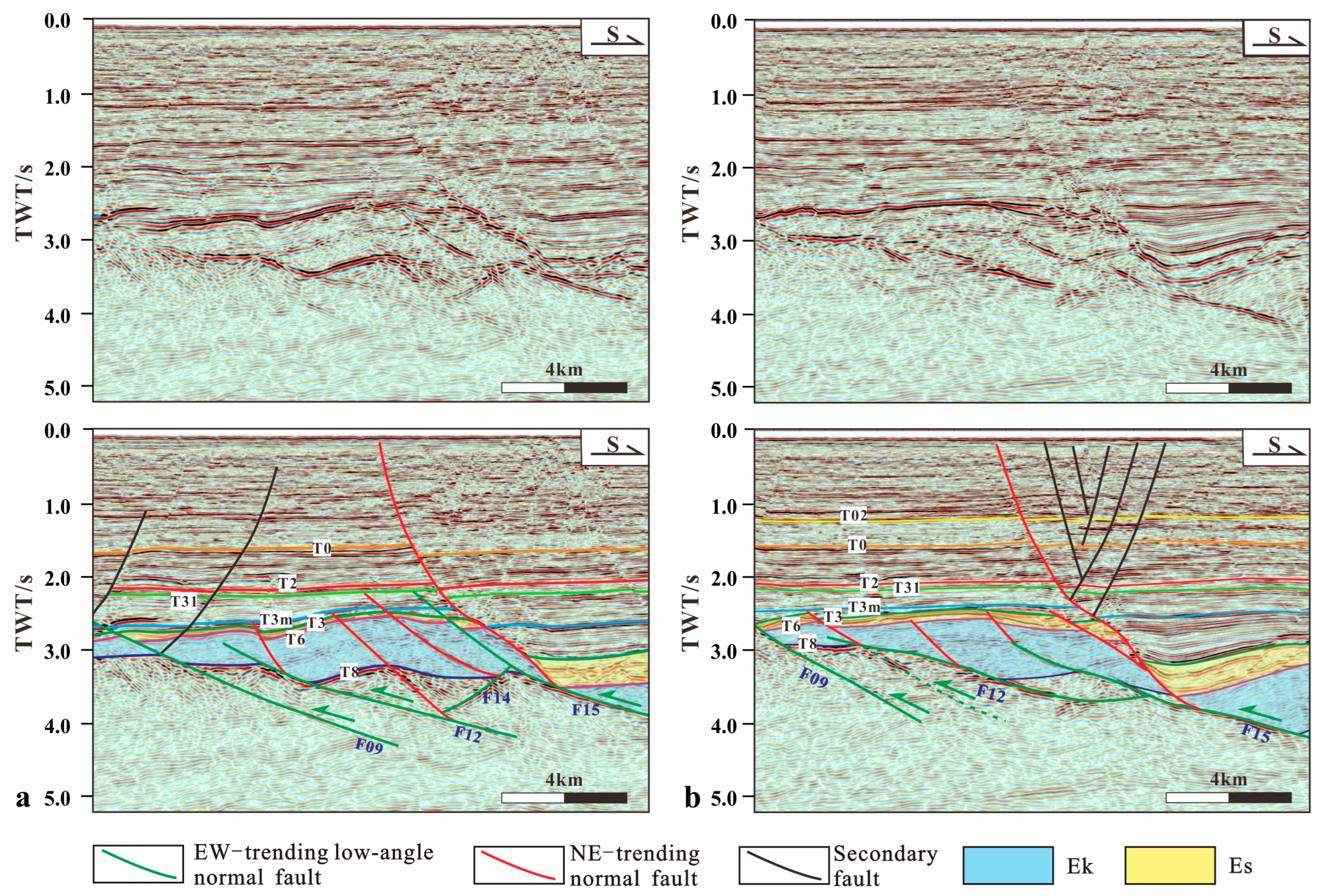
4.1.1. SN-Trending Faults

Four SN-trending faults (F1–F4) are developed and arranged longitudinally in the middle of the study area, which control the zoning characteristics and the trap morphology of the BZ19-6 buried hill (Figure 1c). The scale of the fault is large, and the plane extend length can reach 9.5–20 km. In section views, the SN-trending faults are mainly active below the T3 reflection interface, and the whole fault plane has a steep dip angle of 75–85°. There is little variation in strata thickness in the hanging- and footwall of the fault, while the upper part is connected with other secondary faults, accompanied by negative flower structures (Figure 3 and Figure 4).

4.1.2. NNE-Trending Faults

The NNE-trending faults developed on a large scale. In the plan view, they extend for a long distance and are connected to the SN-trending faults (Figure 1c). On the seismic section, the NNE-trending faults cut all layers and behave like listric faults, where the upper part is steep and the lower part is gentle. The lower part controlled the wedge-shaped strata distribution, while the upper part and secondary faults form a y-shaped structural pattern (Figure 4).

4.1.3. NE–ENE-Trending Faults

The NE–ENE-trending faults are widely distributed in the study area and show a combination of parallel and en-echelon patterns in the plan view. Most of them dip to the south, while a few dip to the north. Faults with different dips are associated with different characteristics of deformation. The south-dipping faults only appear below T3m in a combination of “domino” and “graben-horst” style, controlling the deposition of the Es (Figure 5). The dip angle on the profile is steep and disappears in the buried hill. Some of them overlap with the EW-trending faults. Otherwise, the north-dipping faults cut through all layers and are characterized by long-term activity.

4.1.4. EW-Trending Faults

The EW-trending faults are distributed vertically in the deep stratigraphic layers below the T6 horizon, while laterally they are interposed between the ENE-trending faults (Figure 1c). Vertically, most of them are southward with dip angle less than 30°, which has the geometric characteristics of low-angle normal faults. Compared with ENE-trending faults, these faults have longer extended trajectory on the seismic profile and can reach the basement with very gentle dip (Figure 5).

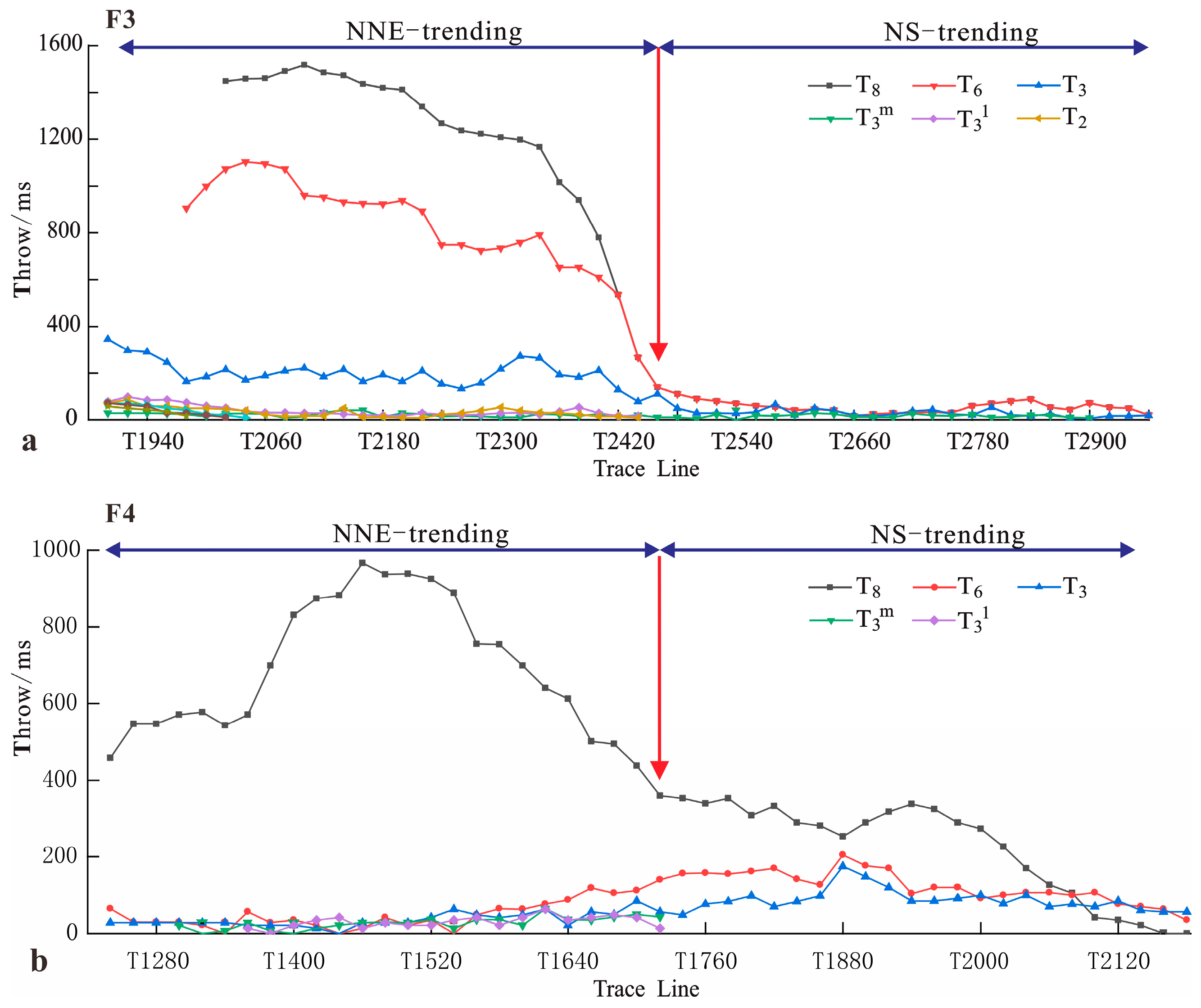
4.2. Kinematic Analysis of Multi-Trend Fault

There are great differences in the growth pattern and active time of different strike faults. T-x plots, T-z plots, and growth index are compiled to determine the generation time, propagation mode, and activity intensity of the faults, and to provide a theoretical basis for recovering the tectonic evolution of the buried hill.
T-x plots demonstrate that most of the faults developed on the 19-6 buried hill have maximum throw at the T8 reflection interface (Figure 6 and Figure 7). For a few single-trending faults (NE-ENE trending faults), the fault throw changes continuously along the strike and decreases gradually from the nucleation point to the lateral tip (Figure 6a), while for the multi-trending faults, the T-x plots show that these faults have obvious segmented characteristics, which are commonly generated by the connection of early-existed segmented faults during the late fault propagation (Figure 6b and Figure 7). Taking the F3 fault as an example (Figure 7a), the T-x plots show a strong drop in fault throw at T2460, which divides the fault into two segments. The southern segment is striking NNE, the maximum throw occurring at the T8 reflection interface, and a large variation of fault throw between different layers. The northern segment is striking S-N, where the fault throw of each layer has no obvious change. Similarly, the T-x plots of the F4 fault also show a minimum value of throw at T1700, representing the change in fault strike and segmentation of the fault (Figure 7b). The T-x plots of the ENE- and EW-trending connection faults also showed the minimum fault throw is often found at the place where the fault has a sudden change in strike (Figure 6b).
T-z plots show that the throw of the SN-trending fault gradually decreases from deep layers to shallow layers, and the gradient of fault throw remains positive while the growth index is approximately unchanged, equal to 1, indirectly indicating that strike-slip faulted strata mainly occur during the growth and evolution of faults, and it does not directly control the formation deposition (Figure 8 ①–②). For the NEE-trending faults, the maximum fault throw occurs near the T8 surface and decreases upward gradually, the T-z plot is a discontinuous semi-“C” shape, which is consistent with the growth law of the multi-phase cyclic fault. The growth index is greater than 1 in the Mesozoic, demonstrating that the NNE-trending faults were formed in the Mesozoic era and controlled the deposition of Mesozoic strata (Figure 8 ③–④). The T-z plots of the EW-trending faults are half “C”-shaped, and the fault throw decreases from deep strata to shallow strata and disappears upward into the Es, which is an early normal fault (Figure 8 ⑤–⑧). The south-dipping ENE-trending faults share similar characteristics with the EW-trending faults on the T-z plots (Figure 8 ⑨–⑫); otherwise, the north-dipping ENE-trending faults cut through all layers, showing an “M” shape on the T-z plots (Figure 3), which indicates that the fault is formed by the dip linkage of two fault segments (Figure 8 ⑬–⑭) [19].

4.3. Main Controlling Factors of Fault Formation

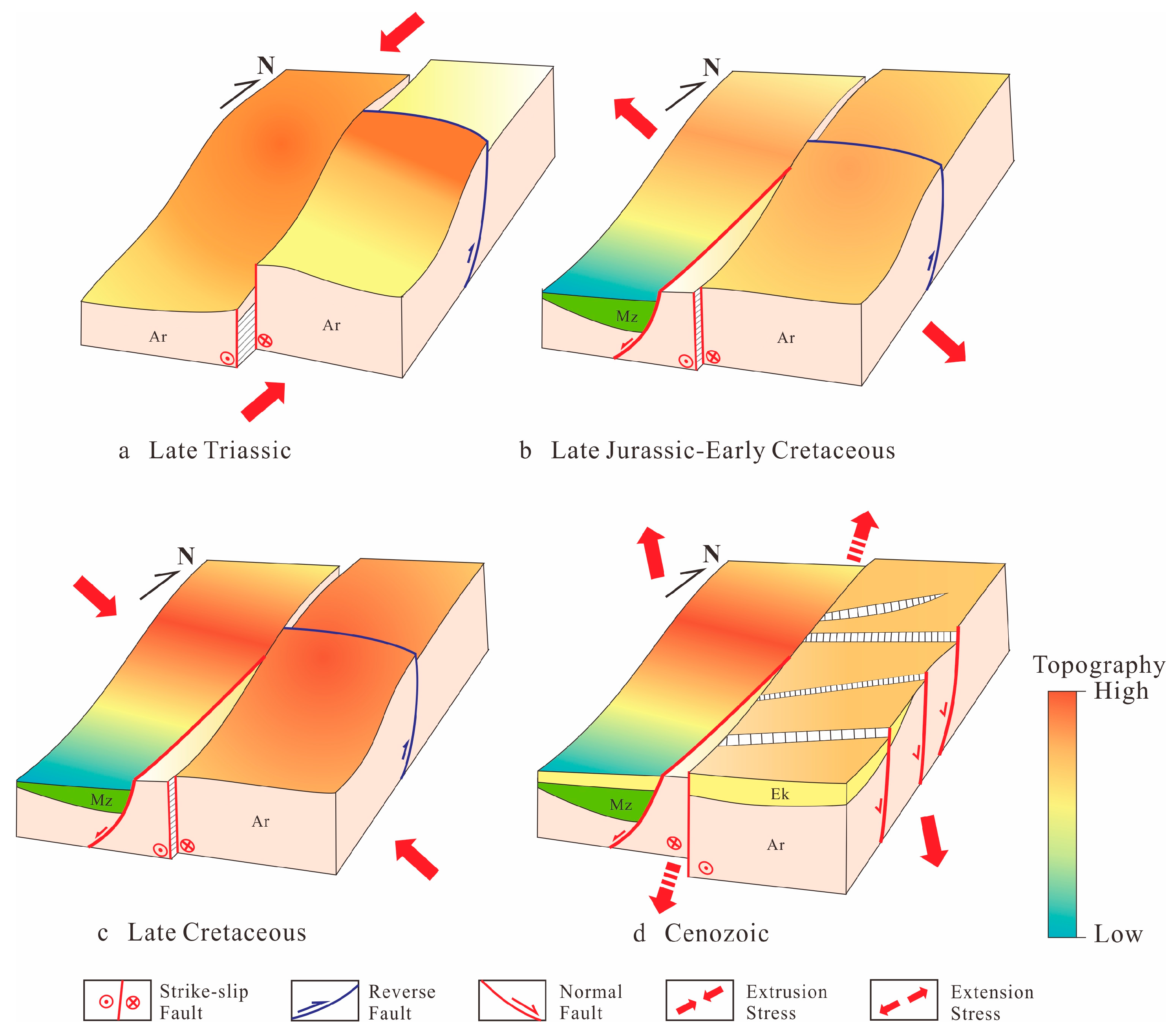
4.3.1. Various Stress Phases Caused by Plate Interaction

The stress field induced by plate interaction is the main driving force for the evolution of large basins and the formation of internal faults. Since the Mesozoic, the Bohai Bay Basin has mainly been affected by three tectonic movements: the Indochinese Yangtze plate collision with the North China Plate, the Yanshanian Pacific Plate subduction to the Eurasia Plate, and the Himalayan Indian Plate collision with the Eurasia Plate.
During the Triassic Indosinian period, the Bohai Bay Basin was in the tectonic transition stage [22,47] under the influence of the collision between the Yangtze Plate and the North China Craton; the basin has strong compressional uplift under the near S-N-trending compressive stress field, which caused the Paleozoic and Triassic strata to suffer different degrees of denudation, and a series of EW-trending thrust faults and fold structures and SN-trending transverse strike-slip faults were developed at both the margin and the interior area of the basin [47]. During the Late Jurassic–Early Cretaceous–Early Yanshan movement, the influence of the Pacific tectonic domain on the Bohai Bay Basin was gradually increasing. The Pacific plate subducted to WNW-ward and then moved backwards, resulting in the WNW–ESE tensile stress field, which induced the development of the NNE-trending extensional structure and NW-trending transforming structure in North China [26]. During the Late Cretaceous–Late Yanshan movement, the basin returned to the compressive stress field due to the change in the subduction direction and speed of the Pacific Plate, but the stress intensity was much weaker than that of the Triassic [29]. Since the Cenozoic, the collision between the Indian Plate and the Eurasian Plate has generated large-scale Himalaya movement, while the direction of subduction of the Pacific Plate has also rotated gradually from WNW to N. Under this tectonic background, the Bohai Bay Basin experienced the evolution of NW–SE-oriented extensional subsidence in the early Paleocene, SN-oriented extensional subsidence in the late Paleocene and continuous subsidence during the Neogene–Quaternary, forming a large number of NE-trending extensional structures.

4.3.2. The Influence of Pre-Existing Structures

In addition to the regional stress field induced by plate interaction affecting basin evolution and fault formation, the development of preexisting structures and different degrees of reactivation also have an important influence on the development and evolution of the rifted basin structure. Some scholars have pointed out that the Bohai Bay Basin is the result of extensional and strike-slip deformation and reactivation of continental scale faults during the Cenozoic [26,27,31,32]. The data of the Bouguer gravity anomaly, residual gravity anomaly, and electromagnetic sounding profile confirm that there are two pre-existing fault zones in the eastern part of Bohai Bay Basin, namely, the Tanlu fault zone of the NNE trend and the Zhang-peng fault zone of the NWW–EW trend, respectively. Among them, the Tanlu fault zone may originate from the giant suture zone of the Archean or Proterozoic and mainly occurred as a left-lateral strike-slip in the Mesozoic and changed to a right-lateral strike-slip in the Cenozoic, as a long-term active fault controlling the formation and development of the eastern Mesozoic and Cenozoic structures in China. The Zhang-Peng fault zone originates from the subduction and collision between the Yangzi Plate and the North China Plate in the Mesozoic; it initially appeared as a NWW–EW-trending thrust fault. In the Late Jurassic–Early Cretaceous, the fault was negatively reversed by the NNE–SSW extension caused by the lithosphere thinning, and then continued to move in the form of an extensional fault, and in the Late Cretaceous, the fault zone was only weakly active or inactive. The above two groups of fault zones were reactivated to different degrees in the Cenozoic. Regionally, the 19-6 buried hill is located at the intersection of the Tanlu fault zone and Zhang-Peng fault zone; therefore, the multi-trend faults in the buried hill are greatly affected by these two huge pre-existing faults.

5. Discussion

5.1. Formation Mechanism of Multi-Trend Faults

Four groups of fault systems developed at the top of the BZ19-6 buried hill, trending to the NS, NNE, NE, and near EW, respectively. On the T-z plots, all of them show maximum fault throw at the T8 reflection interface, which gradually decrease toward the shallow part. It has already been confirmed that the SN-trending strike-slip faults belong to the west branch of the Tanlu fault zone, which are a product of the SN compression during the Indosinian. In addition, the origins of the other multi-trend normal faults are not clear.
The NNE-trending faults, as long-term active faults within the 19-6 buried hill, controlled the Mesozoic deposition. Combined with the characteristics of growth index greater than 1, it is inferred that NNE-trending faults were formed and had strong activity in the Mesozoic. In addition, the fault strike was approximately perpendicular to the NWW–SEE-oriented regional tensile stress of the Late Jurassic–Early Cretaceous; therefore, the NNE-trending fault is the orthogonal extension fault in this period, and their continuous activity affects the subsequent tectonic evolution of the basin.
The NE–ENE-trending normal faults in the eastern part of the study area are roughly parallel, and the strike is approximately perpendicular to the direction of the tensile stress at rifting stages I–II. On the seismic profiles, they showed a domino tectonic pattern consisting of plate faults with the same dip angle (Figure 3 and Figure 5), which was mainly developed below the T3m reflection interface and controlled the deposition of the Es in the hanging wall. Based on the analysis of fault pattern and regional tectonic stress, it is concluded that the NE–ENE-trending normal faults were orthogonal normal faults under the Cenozoic NW–SE tensile stress, while the oblique extension occurred under the late SN-trending tensile stress.
A series of EW-trending normal faults with an average fault dip of 23° are developed in the southern part of the 19-6 buried hill, which extend far away into the deeper part of the buried hill (Figure 9). Generally, the normal faults with a fault dip angle lower than 35° are called low-angle normal faults [48,49]. The formation of low-angle normal faults may be related to the slip of faults above the detachment zone [50], the result of the rotation of high-angle normal faults [51], or the reactivation of low-angle preexisting structures [52]. According to the typical thrust-imbricated structural pattern composed of the pre-existing faults with strong amplitude reflection (Figure 9) and the dynamic background of Bohai Bay Basin, it can be reasonably concluded that the EW-trending faults originated from the reactivation of the Zhang-Peng fault zone; the initial thrust fault becomes a low-angle normal fault by negative inversion in the subsequent tensile stress environment. In addition to the 19-6 buried hill, the phenomenon of negative inversion of Indosinian thrust faults is very common, some small-scale faults only transform the basin structure partially, such as the small negative inversion faults in Jiyang Depression and Huanghua Depression. There are also large-scale faults that control the sedimentation of the whole basin directly as boundary faults after negative inversion, such as the western boundary fault of the Baxian Depression—Niudong fault [53] and the boundary fault in the Shabei area—Shinan No. 1 and No. 3 faults [54].

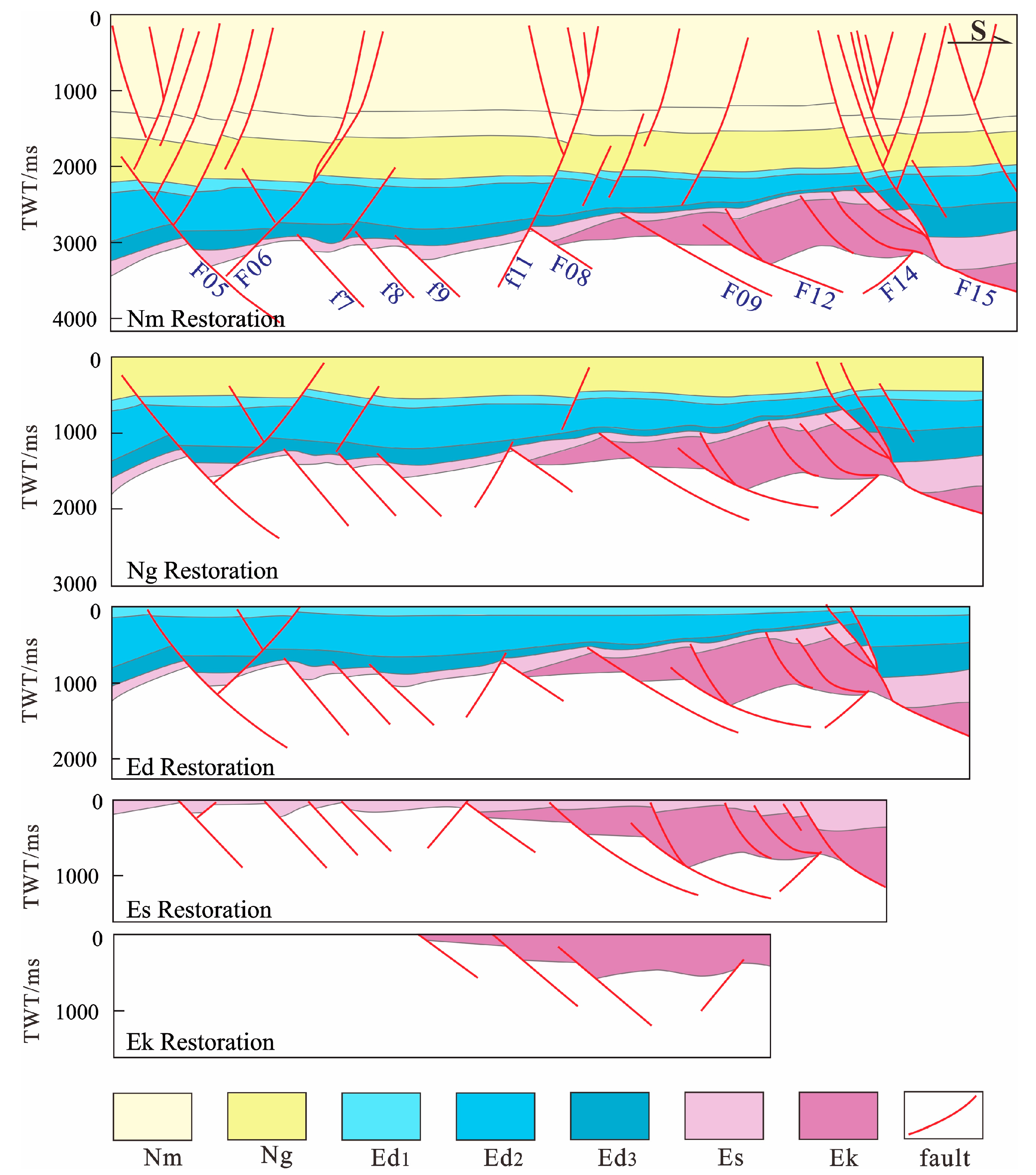
5.2. Evolution Process of Multi-Trend Faults

The evolution process of multi-trend faults on the 19-6 buried hill is the superposition of the pre-existing structure and multi-stage stress field. During the Late Triassic–Early Middle Jurassic, the NWW–EW-trending folds and trust faults (Zhang-Peng fault zone) developed in the Bohai Bay Basin under the influence of the SN-trending compressive stress field induced by the Indosinian movement. The 19-6 buried hill is located in the uplift position and subjected to intense weathering and denudation, resulting in the exposure of Archean metamorphic rocks to the surface [22,25]. In addition, the SN-trending strike-slip faults were formed during this period and are used as transverse faults to regulate the relative motion of the basin interior blocks caused by the difference in compressive stress (Figure 10a). During the Late Jurassic–Early Cretaceous Yanshan movement, under the influence of the Pacific Plate, which moved backward after subduction, the Bohai Bay Basin experienced WNW–ESE stretching [23,26,55]. The NNE-trending normal faults were active at this time to control the local deposition of the Mesozoic sediments (Figure 10b). At the end of the Late Cretaceous Yanshan movement, the northwest-wards subduction of the Pacific plate occurred. At the end of the Late Cretaceous Yanshan movement, the northwestward subduction of the Pacific Plate caused the Bohai Bay Basin to experience compressional stress once again, further intensifying the uplift of the entire BZ19-6 buried hill region (Figure 10c).
After the Mesozoic Indosinian and Yanshan tectonic uplift, the Bohai Bay Basin underwent a tectonic transition and entered the rift stage dominated by NE–ENE-trending faults (Figure 10d) [31]. Combined with fault activity and strata distribution, the tectonic evolution of the Cenozoic 19-6 buried hill can be divided into four stages: ① rifting stage I (Ek); ② rifting stage II (Es); ③ rifting stage Ⅲ (Ed); ④ post-rifting stage (Ng-Nm). During rifting stage I, due to the topography of northern-high and southern-low, the Ek was only deposited in the southern part. It filled up the pre-existing accommodation space and showed a wedge-shaped deposit above the Archaeozoic basement. Under the NW–SE tension stress field, the NNE- and NWW–EW-trending faults formed in the Mesozoic had been reactivated. During the rifting stage II, under the continuous tension stress, a large number of NE-trending normal faults were formed [57,58]. Following the change in subduction direction of the Pacific plate during rifting stage Ⅲ, the regional extension direction changed from NW–SE to near-NS, forming a series of near-EW-trending faults [31,59]. Afterwards, the basin entered the post-rifting stage when it started to deposit the Ng and Nm. The intensity of extensional deformation decreased, and the thermal subsidence effect increased [60] (Figure 11). Some large-scale early faults continued to grow and induced the formation of a dense zone of faults in the shallow part (F05 and F15 in Figure 11). There were also a few late EW-trending faults that propagated downward and connected with early faults to form the same vertical faults (F11 in Figure 11).

5.3. Implications for Hydrocarbon Exploration

Previous exploration has proved that the effective reservoir scale is the key factor restricting the exploration of a buried hill [61] The reservoir consists of a weathering crust-type reservoir on the top of the buried hill and a tectonic fracture-type reservoir inside the buried hill. In this study, tectonic fractures have become the most important reservoir type in buried hill reservoirs, accounting for up to 70% [34,35] (Figure 12) with the characteristics of multi-scale and heterogeneous distribution. Many scholars have suggested that the formation of inner fractures in buried hills is mainly related to fault activities [14,38,61]. Fault activity can change the local stress and then control the fracture development characteristics.
Firstly, according to the fracture intersection relationship and filling sequence, it is found that 4-phase tectonic fractures developed in the 19-6 buried hill; they are Indosinian, Yanshanian, rifting stage I–II, and rifting stage III tectonic fractures, respectively, consistent with the formation period of the multi-trend faults in the buried hill. Secondly, due to the stress being concentrated along the fault zone, the fractures are distributed zonally along the fault. Furthermore, the analysis of fracture density and fault activity show that fractures are often densely distributed around long-term active faults and at the intersection of multiple groups of faults: when the well location is far from the fault or controlled by the NE–ENE-trending single-phase active fault only, the development of a fracture is poor, and the fracture density is only about 1.0 fracture/m or less. The fracture density is greater than 1.0 fracture/m in the area controlled by the NNE-trending or EW-trending long-term active faults. The most densely developed fractures are found in the intersecting area controlled by NNE- and EW-trending faults, which have a density of more than 3.0 fracture/m (Figure 13a).
Thirdly, with the increase in fault scale and aspect ratio, the length of the fracture and the width of the fracture zone also increase. Because it is difficult to measure the fracture length of a buried hill, this paper mainly provides statistics for the width of fracture zone near different scale faults. The fracture zone width is also closely related to fracture activity, which has positively correlated with the fault throw. For example, the NNE-trending normal fault with the largest fault throw in the 19-6 buried hill has the widest width of the fracture zone, followed by the EW-trending normal fault and the NE–ENE-trending fault; the SN-trending fault has the smallest throw, and the width of the fracture zone is also the narrowest (Figure 13b).
Finally, in addition to fracture density and fracture zone width, fault activity also has a certain controlling effect on fracture orientation, effectiveness, and connectivity. The imaging logs show that the fractures in the 19-6 buried hill are mainly oriented ENE, near EW, and NW (Figure 13c), which is consistent with the strike of the normal faults at the top of the buried hill. However, not all strike faults have good correspondence with the strike of the highly conductive fractures; only the ones controlled by NE-ENE-trending faults have a very good correlation (Figure 13d). The dominant striking of the highly conductive fractures controlled by the EW-trending normal faults is EW, but there are also fractures with other strikes, such as the SN strike in well a, and the ENE strike in well d (Figure 13e). The orientation of highly conductive fractures controlled by NNE- and SN-trending faults has little relationship with the master fault orientation, but more closely matches the late tensile stress direction—SN (Figure 13f). The reason may be that the NNE-trending and NS-trending faults were formed in the Mesozoic, and the fractures generated by early fault activities were easier to fill; however, the NE–ENE-trending faults were formed in the Cenozoic, and some of the them were reactivated in rifting stage III, which not only promoted the generation of new fractures, but also made the early closed fractures open again and become effective reservoirs.
In summary, the long-term active large-scale faults formed in the Mesozoic Indosinian and Yanshan movements are the key to controlling the formation of fractures, and the Cenozoic Himalayan movement can reactivate the earlier filled fractures and generate new fractures. Therefore, the position where multi-stage faults are superimposed together is the favorable position of a high-quality inner reservoir.

6. Conclusions

  • Four group faults with various orientations developed on the top of the BZ19-6 buried hill in response to three tectonic movements of the Mesozoic Indosinian, Yanshan, and Cenozoic Himalayan. These faults include SN-trending strike-slip faults, NNE-trending, NE–ENE-trending, and near EW-trending normal faults. The SN-trending faults formed in the Mesozoic Indosinian. The NNE-trending faults were initially formed under orthogonal extension of the WNW–ESE-oriented extensional setting during the early Yanshan period. The EW-trending normal faults originated from the negative inversion and reactivation of the EW-trending preexisting thrust faults that initially formed in the Mesozoic Indosinian. The NE–ENE-trending normal faults developed as newly formed structures during the Cenozoic Himalayan period.
  • The BZ19-6 buried hill was formed in the process of multi-stage tectonic superposition in the Meso-Cenozoic. During the Indosinian, the buried hill was initially formed in anticlinal form under the strong SN-oriented compressional stress. During the early Yanshanian, the WNW–ESE-oriented extensional setting resulted in the deposition of Mesozoic strata on the buried hill. During the late Yanshanian, the buried hill was subjected to weak NW–SE-oriented compression, and the uplift strength was further enhanced. At the beginning of the Cenozoic, the BZ19-6 entered into the rifting stage. The specific tectonic evolution process can be divided into: ① rifting stage I (Ek); ② rifting stage II (Es); ③ rifting stage Ⅲ (Ed); ④ post-rifting stage (Ng-Nm). The newly formed structures in the Cenozoic complicated the geomorphology of the top surface of the buried hill.
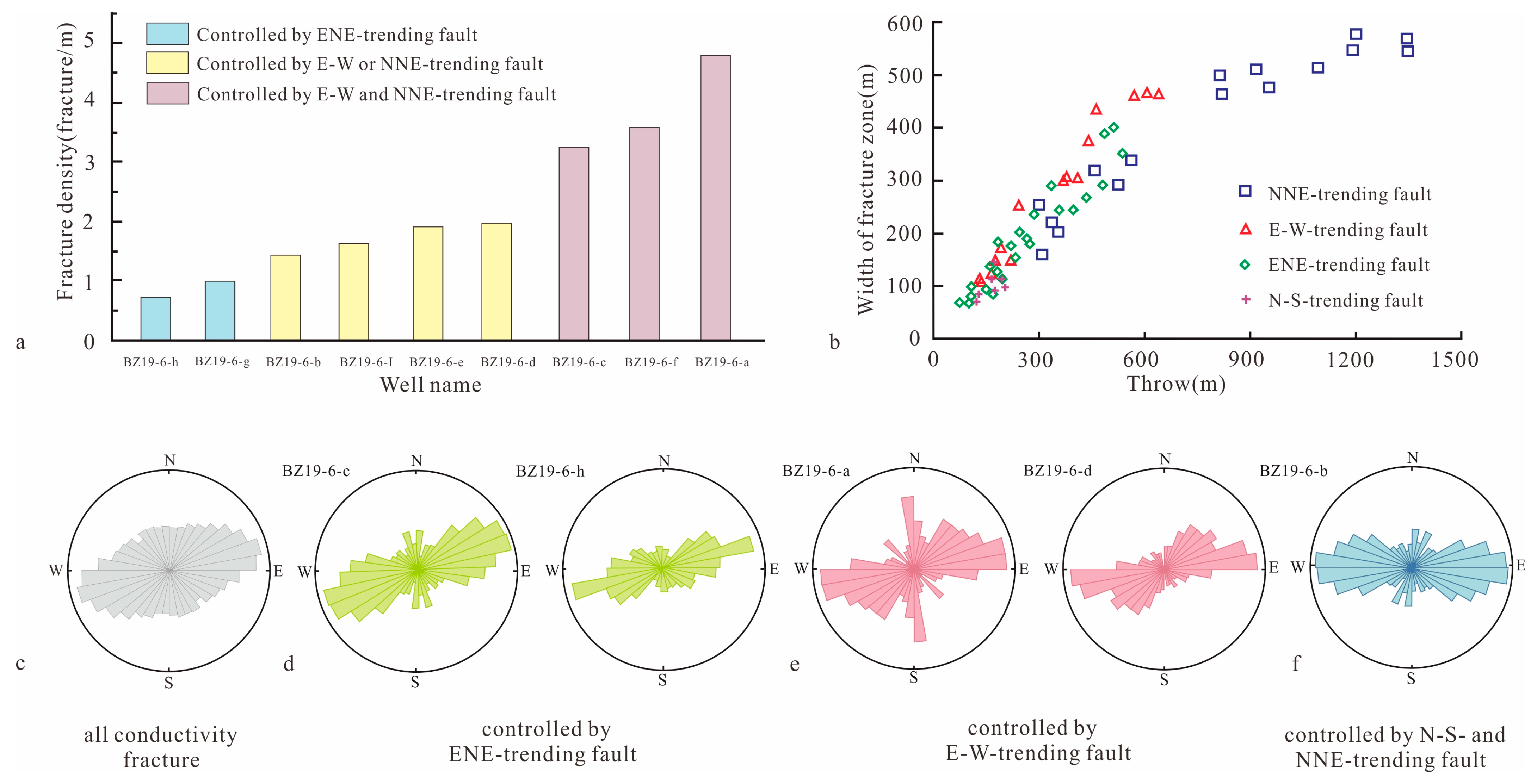
  • A large-scale effective reservoir is a necessary condition for the hydrocarbon accumulation in a buried hill. Multi-trend faults control the formation of tectonic fractures and therefore control the distribution of high-quality reservoirs. The fault activity has a certain controlling effect on fracture density, fracture zone width, fracture orientation, effectiveness, and connectivity. Fractures are densely developed near long-term active faults and the width of a fracture zone is positively correlated with fault throw. Compared with faults in the Indosinian and Yanshanian, faults formed in the Himalayan have a stronger correlation with the strike of fractures, and the fracture effectiveness and connectivity are higher. Therefore, the area where multi-strike faults are superimposed is the favorable area for high-quality inner reservoir development.

Author Contributions

Conceptualization, R.L. and Y.S.; methodology, T.G.; validation, R.L.; investigation, F.J.; data curation, Y.L.; writing—original draft, R.L.; writing—review & editing, R.L.; visualization, F.J.; supervision, T.G.; funding acquisition, Y.S. All authors have read and agreed to the published version of the manuscript.

Funding

This study was founded by the the National Natural Science Foundation of China (Grant No. 42472190), The project of Chongqing Natural Science Foundation Innovation For Innovation and Development Joint Fund (No. CSTB2022NSCQ-LZX0020) and The Project of Chongqing Talent Innovation Leading Talent for Education Field (No. 0255-19230101042).

Institutional Review Board Statement

Not applicable.

Informed Consent Statement

Not applicable.

Data Availability Statement

Data is contained within the article.

Conflicts of Interest

Tian Gao was employed by Research Institute of Exploration and Development, PetroChina Liaohe Oilfield Company. The remaining authors declare that the research was conducted in the absence of any commercial or financial relationships that could be construed as a potential conflict of interest.

References

  1. Lima, B.E.M.; Tedeschi, L.R.; Pestilho, A.S.; Santos, R.V.; Ros, L.F.D. Deep-burial hydrothermal alteration of the Pre-Salt carbonate reservoirs from northern Campos Basin, offshore Brazil: Evidence from petrography, fluid inclusions, Sr, C and O isotopes. Mar. Petrol. Geol. 2020, 113, 104143. [Google Scholar] [CrossRef]
  2. Cao, Y.C.; Yuan, G.H.; Yang, H.J.; Wang, Y.Z.; Liu, K.Y.; Zan, N.M.; Xi, K.L.; Wang, J. Current situation of oil and gas exploration and research progress of the origin of high-quality reservoirs in deep-ultra-deep clastic reservoirs of petroliferous basins. Acta Pet. Sin. 2022, 43, 112–140. (In Chinese) [Google Scholar] [CrossRef]
  3. Jia, C.Z. Development challenges and future scientific and technological researches in China’s petroleum industry upstream. Acta Petrolei Sinica. 2020, 41, 1445–1464. [Google Scholar] [CrossRef]
  4. Ajdukiewicz, J.M.; Nicholson, P.H.; Esch, W.L. Prediction of deep preservoir quality using early diagenetic process models in the Jurassic Norphlet Formation, Gulf of Mexico. AAPG Bull. 2010, 94, 1189–1227. [Google Scholar] [CrossRef]
  5. Dutton, S.P.; Loucks, R.G. Diagenetic controls on evolution of porosity and permeability on Lower Tertiary wilcox sand-stones from shallow to ultradeep (200-6700m) burial, Gulf of Mexico Basin, USA. Mar. Petrol. Geol. 2010, 27, 69–81. [Google Scholar] [CrossRef]
  6. Nguyen, B.T.T.; Jones, S.J.; Goulty, N.R.; Middleton, A.J.; Grant, N.; Ferguson, A.; Bowen, L. The role of fluid pressure and diagenetic cements for porosity preservation in Triassic fluvial reservoirs of the Central Graben, North Sea. AAPG Bull. 2013, 97, 1273–1302. [Google Scholar] [CrossRef]
  7. Novikov, D.A. Equilibrium modeling of water-gas systems in Jurassic–Cretaceous reservoirs of the Arctic petroleum province, northern West Siberia. Pet. Explor. Dev. 2022, 49, 319–329. [Google Scholar] [CrossRef]
  8. Yang, K.S. Discovery and geologic characteristics of Renqiu Oilfield with buried hill. Fault-Block Oil. Gas Field. 2010, 17, 525–528. [Google Scholar]
  9. Feng, Y.; Liu, G.D.; Yang, W.W.; Gong, Y.J. Characteristics and models of hydrocarbon accumulation in Xinglongtai Oilfield, Liaohe Depression. Mar. Geol. Quat. Geol. 2014, 34, 137–143. (In Chinese) [Google Scholar]
  10. Zang, M.F.; Wu, K.Y.; Cui, Y.Q.; Du, W.L. Types of Buried Hill and Its Hydrocarbon Accumulation in Jizhong Depression. J. Oil Gas Technol. 2009, 31, 166–169. [Google Scholar]
  11. Zhu, J.Q.; Zhang, Y.M.; Huang, Y.X.; Ming, J.; Zhao, W.S.; Wu, L.; Gan, Y.C.; Wang, Y.J. The hydrocarbon accumulation characteristics of diverse buried hills in the Shulu sag, Jizhong depression. China Pet. Explor. 2019, 24, 791–798. [Google Scholar] [CrossRef]
  12. Jiang, P. A pool formation analysis for Qianmiqiao buried hill structure. Pet. Explor. Dev. 2000, 27, 14–16. [Google Scholar] [CrossRef]
  13. Levorsen, A.I. Geology of Petroleum; W. H. Freeman: San Franciso, CA, USA, 1954. [Google Scholar]
  14. Xue, Y.A.; Zhao, M.; Liu, X.J. Reservoir Characteristics and Controlling Factors of the Metamorphic Buried Hill of Bozhong Sag, Bohai Bay Basin. J. Earth Sci. 2021, 32, 919–926. [Google Scholar] [CrossRef]
  15. Ye, T.; Chen, A.Q.; Niu, C.M.; Wang, Q.B. Structural, petrophysical and lithological characterization of crystalline bedrock buried-hill reservoirs: A case study of the southern jinzhou oilfield in offshore Bohai Bay Basin, north China—ScienceDirect. J. Pet. Sci. Eng. 2020, 196, 107950. [Google Scholar] [CrossRef]
  16. Zhang, P.F.; Liu, H.M.; Cao, Z.X.; Tian, M.R.; Tang, D.; Ma, S.K. Analysis on main controlling factors of archaeozoic weathering crust reservoir: With Jiyang and Luxi area example. J. Jilin Univ. Earth Sci. Ed. 2015, 45, 1289–1298. [Google Scholar]
  17. Xue, Y.A. The breakthrough of the deep-buried gas exploration in the Bohai Sea area and its enlightenment. Nat. Gas Ind. 2019, 39, 11–20. [Google Scholar] [CrossRef]
  18. Zeng, L.B.; Gong, L.; Zhang, Y.Z.; Dong, S.Q.; Lv, W.Y. A review of the genesis, evolution, and prediction of natural fractures in deep tight sandstones of China. AAPG Bulletin. 2023, 107, 1687–1721. [Google Scholar] [CrossRef]
  19. Lou, R.; Sun, Y.H.; Fan, T.E.; Fan, H.J.; Liu, L. Influence of multi-trend major fault reactivation during multiphase rifting: Beier Depression, Hailar Basin, NE China. Geol. Mag. 2022, 159, 1767–1786. [Google Scholar] [CrossRef]
  20. Deng, H.; McClay, K. Development of extensional fault and fold system: Insights from 3D seismic interpretation of the Enderby Terrace, NW Shelf of Australia. Mar. Petrol. Geol. 2019, 104, 11–28. [Google Scholar] [CrossRef]
  21. Morley, C.K. The impact of multiple extension events, stress rotation and inherited fabrics on normal fault geometries and evolution in the Cenozoic rift basins of Thailand. Geol. Soc. Lond. Spec. Publ. 2017, 439, 413–445. [Google Scholar] [CrossRef]
  22. Yu, F.S.; Qi, J.F.; Wang, C.Y. Tectonic Deformation of Indosinian Period in Eastern Part of North China. J. China Univ. Min. Technol. 2002, 31, 402–406. [Google Scholar] [CrossRef]
  23. Zhu, R.X.; Xu, Y.G.; Zhu, G. Destruction of the North China Craton. Sci. China Earth Sci. 2012, 42, 1135–1159. [Google Scholar] [CrossRef]
  24. Li, S.Z.; Suo, Y.H.; Dai, L.M.; Liu, L.P.; Jin, C.; Liu, X.; Hao, T.Y.; Zhou, L.H.; Liu, B.H.; Zhou, J.T.; et al. Development of the Bohai Bay Basin and destruction of the North China Craton. Earth Sci. Front. 2010, 17, 64–89. [Google Scholar]
  25. Zhai, M.G. Cratonization and the Ancient North China Continent: A summary and review. Sci. China Earth Sci. 2011, 54, 1110–1120. [Google Scholar] [CrossRef]
  26. Ma, Y.K.; Sun, Y.H.; Ma, Y.; Jiang, W.Y.; Sun, X. Tectonic evolution and genesis of fault zones in Qikou sag, Bohai Bay Basin. Acta Petrolei Sinica 2020, 41, 526–529. [Google Scholar]
  27. Yu, Y.X.; Zhou, X.H.; Xu, C.G.; Wu, K.; Lv, D.Y.; Liu, Y.B.; Zhou, X. Architecture and evolution of the Cenozoic offshore Bohai Bay Basin, eastern China. J. Asian Earth Sci. 2020, 192, 104272. [Google Scholar] [CrossRef]
  28. Zhang, G.H.; Zhang, J.P. A discussion on the tectonic inversion and its mechanism in the East China Sea Shelf Basin. Earth Sci. Front. 2015, 22, 260–270. [Google Scholar] [CrossRef]
  29. Li, Z.; Qu, H.; Gong, W. Late Mesozoic basin development and tectonic setting of the northern North China Craton. J. Asian Earth Sci. 2015, 114, 115–139. [Google Scholar] [CrossRef]
  30. Zhu, R.; Zhang, H.; Zhu, G.; Meng, Q.; Fan, H.; Yang, J.; Wu, F.; Zhang, Z.; Zheng, T. Craton destruction and related resources. Int. J. Earth Sci. 2017, 106, 2233–2257. [Google Scholar] [CrossRef]
  31. Lou, R.; Sun, Y.H.; Tian, W.G.; Gao, T. Segmented growth of reactivated major bounding faults and their control on basin structures: Insights from the Nanpu Sag, Bohai Bay Basin, eastern China. Basin Res. 2024, 36, e12852. [Google Scholar] [CrossRef]
  32. Liang, J.T.; Wang, H.L.; Bai, Y.; Ji, X.Y.; Duo, X.M. Cenozoic tectonic evolution of the Bohai Bay Basin and its coupling relationship with Pacific Plate subduction. J. Asian Earth Sci. 2016, 127, 257–266. [Google Scholar] [CrossRef]
  33. Niu, C.M.; Wang, F.L.; He, J.Q.; Tang, G.M. Accumulation factor matching and model of Bozhong 19-6 buried hill gas reservoir, Bohai Sea area. Pet. Geol. Exp. 2021, 43, 259–267. [Google Scholar] [CrossRef]
  34. Ye, T.; Niu, C.M.; Wang, Q.B.; Dai, L.M.; Li, F. Characteristics and controlling factors of large bedrock buried-hill reservoirs in the Bohai Bay Basin—A case study of the BZ19-6 condensate filed. Acta Geologica Sinica. 2021, 95, 1889–1902. [Google Scholar] [CrossRef]
  35. Ye, T.; Chen, A.Q.; Niu, C.M.; Luo, J.; Hou, M.C. Effective fractures linked with tectonic reactivation and multiple genetic fluids in the ultradeep Paleozoic carbonate buried hills of the Bozhong sag, North China. Mar. Petrol. Geol. 2022, 140, 105642. [Google Scholar] [CrossRef]
  36. Marrett, R.; Gale, J.F.W.; Gómez, L.A.; Laubach, S.E. Correlation analysis of fracture arrangement in space. J. Struct. Geol. 2018, 108, 16–33. [Google Scholar] [CrossRef]
  37. Procter, A.; Sanderson, D.J. Spatial and layer-controlled variability in fracture networks. J. Struct. Geol. 2018, 108, 52–65. [Google Scholar] [CrossRef]
  38. Gong, L.; Su, X.C.; Gao, S.; Fu, X.F.; Jabbari, H.; Wang, X.X.; Liu, B.; Yue, W.T.; Wang, Z.S.; Gao, A. Characteristics and formation mechanism of natural fractures in the tight gas sandstones of Jiulongshan gas field, China. J. Petrol. Sci. Eng. 2019, 175, 1112–1121. [Google Scholar] [CrossRef]
  39. Radwan, A.E.; Abdelghany, W.K.; Elkhawaga, M.A. Present-day in-situ stresses in Southern Gulf of Suez, Egypt: Insights for stress rotation in an extensional rift basin. J. Struct. Geol. 2021, 147, 104334. [Google Scholar] [CrossRef]
  40. Bashmagh, N.M.; Lin, W.R.; Radwan, A.E.; Manshad, A.K. Comprehensive analysis of stress magnitude and orientations and natural fractures in complex structural regimes oil reservoir: Implications for tectonic and oil field development in the Zagros suture zone. Mar. Petrol. Geol. 2024, 160, 106615. [Google Scholar] [CrossRef]
  41. Cartwright, J.A.; Mansfield, C.S. Lateral displacement variation and lateral tip geometry of normal faults in the Canyonlands National Park, Utah. J. Struct. Geol. 1998, 20, 3–19. [Google Scholar] [CrossRef]
  42. Jackson, A.L.; Rotevatn, A. 3D seismic analysis of the structure and evolution of a salt-influenced normal fault zone: A test of competing fault growth models. J. Struct. Geol. 2013, 54, 215–234. [Google Scholar] [CrossRef]
  43. Baudon, C.; Cartwright, J. Early stage evolution of growth faults: 3D seismic insights from the Levant Basin, Eastern Mediterranean. J. Struct. Geol. 2008, 30, 888–898. [Google Scholar] [CrossRef]
  44. Baudon, C.; Cartwright, J. The kinematics of reactivation of normal faults using high resolution throw mapping. J. Struct. Geol. 2008, 30, 1072–1084. [Google Scholar] [CrossRef]
  45. Baudon, C.; Cartwright, J. 3D seismic characterisation of an array of blind normal faults in the Levant Basin, Eastern Mediterranean. J. Struct. Geol. 2008, 30, 746–760. [Google Scholar] [CrossRef]
  46. Tvedt, A.B.M.; Rotevatn, A.; Jackson, A.L. Growth of normal faults in multilayer sequences: A 3D seismic case study from the Egersund Basin, Norwegian North Sea. J. Struct. Geol. 2013, 55, 1–20. [Google Scholar] [CrossRef]
  47. Li, H.Y.; Xiao, S.G.; Li, F.; Sun, Z.; Liu, K. Structural characteristics of the Western Branch of the Tanlu fault in Bohai Sea and its control on the formation of buried hills. Bull. Geol. Sci. Technol. 2021, 40, 33–41. [Google Scholar] [CrossRef]
  48. Axen, G.J. Research focus: Significance of large-displacement, low-angle normal faults. Geology 2007, 35, 287–288. [Google Scholar] [CrossRef]
  49. Morley, C.K. The widespread occurrence of low-angle normal faults in a rift setting: Review of examples from Thailand, and implications for their origin and evolution. Earth-Sci. Rev. 2014, 133, 18–42. [Google Scholar] [CrossRef]
  50. Fossen, H.; Odinsen, T.; Faerseth, R.B.; Gabrielsen, R.H. Detachments and low-angle faults in the northern North Sea rift system. Geol. Soc. Lond. Spec. Publ. 2000, 167, 105–131. [Google Scholar] [CrossRef]
  51. Whitney, D.L.; Teyssier, C.; Rey, P.; Buck, W.R. Continental and oceanic core complexes. GSA Bull. 2013, 125, 273–298. [Google Scholar] [CrossRef]
  52. Li, J.H.; Zhang, Y.Q.; Dong, S.W.; Su, J.B.; Li, Y.; Cui, J.J.; Shi, W. The Hengshan low-angle normal fault zone: Structural and geochronological constraints on the Late Mesozoic crustal extension in South China. Tectonophysics 2013, 606, 97–115. [Google Scholar] [CrossRef]
  53. Dong, D.W.; Li, L.; Liu, J.; Li, J. Cenozoic tectonic evolution in the north-central Jizhong Depression. Oil Gas Geol. 2013, 34, 771–780. [Google Scholar] [CrossRef]
  54. Wang, G.M.; Pang, X.J.; Zhang, X.F.; Liu, B.B. Activity of Shinan fault and its control on hydrocarbon accumulation in the Paleogene in Bozhong Depression. Oil Gas Geol. 2012, 33, 859–866. [Google Scholar] [CrossRef]
  55. Zheng, J.P.; Dai, H.K. Subduction and retreating of the western Pacific plate resulted in lithospheric mantle replacement and coupled basin-mountain respond in the North China Craton. Sci. China Earth Sci. 2018, 61, 406–424. [Google Scholar] [CrossRef]
  56. Li, H.Y.; Xu, Y.L.; Wang, F.L.; Luo, X.P.; Yu, H.B. Geochemical characteristics and sources of oil and gas in deep buried hills, Bohai Sea area. Nat. Gas Ind. 2019, 39, 45–56. [Google Scholar] [CrossRef]
  57. Bao, H.Y.; Guo, Z.F.; Zhang, L.L.; Huang, Y. Tectonic dynamics of eastern China since the formation of the Pacific plate. Adv. Earth Sci. 2013, 28, 337–346. [Google Scholar] [CrossRef]
  58. Liu, M.; Cui, X.; Liu, F. Cenozoic rifting and volcanism in eastern China: A mantle dynamic link to the indo–asian collision? Tectonophysics 2004, 393, 29–42. [Google Scholar] [CrossRef]
  59. Ren, J.Y. Genetic dynamics of China offshore Cenozoic basins. Earth Sci. 2018, 43, 3337–3361. [Google Scholar] [CrossRef]
  60. Teng, C.Y.; Zou, H.Y.; Hao, F. Control of differential tectonic evolution on petroleum occurrence in Bohai Bay Basin. Sci. China Earth Sci. 2014, 44, 579–590. [Google Scholar] [CrossRef]
  61. Zhou, X.H.; Zhang, R.C.; Li, H.Y.; Wang, B.Q.; Guo, Y.H. Major controls on natural gas accumulations in deep-buried hills in Bozhong Depression, Bohai Bay Basin. J. China Univ. Pet. (Ed. Nat. Sci.) 2017, 41, 42–50. [Google Scholar] [CrossRef]
Figure 1. (a) Tectonic location of Bohai Bay Basin, modified from [17]. (b) Major tectonic units of Bozhong sag (BZ: Bozhong; CZK: Chengzikou; CB: Chengbei; SLT: Shaleitian; SJT: Shijiutuo; QN: Qinnan; BN: Bonan; HHK: Huanghekou; LB: Laibei). (c) Index map showing the distribution of fault developed at the top of the BZ19-6 buried hill. (d) Seismic section across the BZ19-6 buried hill.
Jmse 12 01727 g001
Figure 2. Stratigraphic column of the BZ19-6 buried hill, modified from [34,35].
Jmse 12 01727 g002
Figure 3. (a1) Seismic and (a2) geological section in the middle of the BZ19-6 buried hill, (b1) Seismic and (b2) geological section in the north of the BZ19-6 buried hill (see Figure 1c for location).
Jmse 12 01727 g003
Figure 4. (a1) Seismic and (a2) geological section in the south of the BZ19-6 buried hill, (b1) Seismic and (b2) geological section in the middle of the BZ19-6 buried hill (see Figure 1c for location).
Jmse 12 01727 g004
Figure 5. (a) Seismic and (b) geological section in the east of the BZ19-6 buried hill (see Figure 1c for location).
Jmse 12 01727 g005
Figure 6. T-x plots of (a) ENE-trending faults and (b) EW–ENE-trending faults.
Jmse 12 01727 g006
Figure 7. T-x plots of (a) F3 and (b) F4.
Jmse 12 01727 g007
Figure 8. Distribution map of faults developed at the top of the buried hill and their fault throw variation curves along dip ①–②: T-z plots of NS-trending faults and their growth index, ③–④: T-z plots of NNE trending faults and their growth index, ⑤–⑧: T-z plots of EW-oriented faults, ⑨–⑫: T-z plots of southward NE–NEE-trending faults, ⑬–⑭: T-z plots of northward NE–NEE-trending faults.
Jmse 12 01727 g008
Figure 9. (a) West and (b) east seismic section across the EW-trending low-angle normal fault (see Figure 1c for location).
Jmse 12 01727 g009
Figure 10. The tectonic evolution models of the BZ19-6 buried hill (modified after [56]). (a) Map showing an initial stage of buried hill formation during Mesozoic Indosinian, the paleogeomorphology is high in the north and low in the south, with SN-trending strike-slip faults and EW-trending thrust faults. (b,c) Maps showing the deformation of buried hill during Mesozoic Yanshanian, the NEE–SWW-trending extensional fault developed in early Yanshanian and further uplifted of buried hill in late Yanshanian. (d) During the Cenozoic, the top of the buried hill had been strongly transformed, the NNE-trending normal faults were still active and the EW-trending thrust fault inversed into normal faults, and the NE–ENE-trending normal fault were formed.
Jmse 12 01727 g010
Figure 11. The Cenozoic tectonic evolution profile of the Bozhong M buried hill (see Figure 1c for location).
Jmse 12 01727 g011
Figure 12. Fracture development characteristics and electrical relationship in the core section of well BZ19-6-g. (a) Core pictures, (b) imaging logs, and (c) log curve.
Jmse 12 01727 g012
Figure 13. (a) Statistical chart of fracture density controlled by different striking faults, (b) the relationship between the width of fractured zone and fault throw, (c) rose diagram of the strikes of the highly conductive fractures, (d) rose diagram of the strikes of fractures controlled by ENE-trending faults, (e) rose diagram of the strikes of fractures controlled by EW-trending faults, (f) rose diagram of the strikes of fractures controlled by NS-and NNE-trending faults.
Jmse 12 01727 g013
Disclaimer/Publisher’s Note: The statements, opinions and data contained in all publications are solely those of the individual author(s) and contributor(s) and not of MDPI and/or the editor(s). MDPI and/or the editor(s) disclaim responsibility for any injury to people or property resulting from any ideas, methods, instructions or products referred to in the content.

