Article

Effects of Coastal Reclamation on the Topographic Changes of an Open Estuary: A Case Study in Taizhou Bay, East China

1
Second Institute of Oceanography, Ministry of Natural Resources, Hangzhou 310012, China
2
Key Laboratory of Ocean Space Resource Management Technology, Ministry of Natural Resources, Hangzhou 310012, China
3
Ocean College, Zhejiang University, Zhoushan 316021, China
*
Authors to whom correspondence should be addressed.
J. Mar. Sci. Eng. 2024, 12(10), 1744; https://doi.org/10.3390/jmse12101744
Submission received: 31 August 2024 / Revised: 21 September 2024 / Accepted: 23 September 2024 / Published: 3 October 2024
(This article belongs to the Section Geological Oceanography)

Abstract

:
Analyzing the processes and influencing factors of accretion or erosion in estuaries and tidal basins is important for coastal conservation and utilization, planning, and ecosystem maintenance. This study analyzed the process of topographic changes in Taizhou Bay, China over the past five decades by comparing bathymetric datasets from different years. The coastlines were extracted via remote sensing image interpretation, and the coastal reclamation process was analyzed. The results revealed that this bay experienced slow siltation from 1963 to 2004, which mainly occurred on mudflats and shore slopes. It turned into a feature dominated by erosion between 2004 and 2013, and erosion increased between 2013 and 2019. Coastal reclamation has occurred during every 10-year period since the 1960s. Reclamation occupied a portion of the intertidal flat, decreased the tidal prism, and changed tidal asymmetry, causing net sediment to be transported into the bay and accumulate on the intertidal flat and upper part of the subaqueous shore. The drastic reduction in sediment supply caused by the Three Gorges Dam may have been responsible for erosion from 2004 to 2019. A negative feedback process exists between tidal flat expansion and coastal reclamation. The compensatory expansion of the tidal flat is a much slower process than the advance of reclamation.

1. Introduction

Estuaries and tidal basins have tidal flats and channels with fine-grained sediment supplies. Tidal flats are important coastal ecosystems that provide critical habitats for wildlife [1,2] and ecosystem services to coastal communities [3], and they represent sinks for organic carbon, which affects global carbon cycling [4,5]. Tidal channels provide access for material transportation and ship navigation. It is important to analyze the processes of accretion or erosion in tidal basins for coastal conservation and utilization, planning, and ecosystem maintenance.
Tidal flats in natural estuaries and tidal basins can accumulate at a faster rate than the relative sea level rise, with enough sediment supply [6]. This process may lead to slow siltation in estuaries and tidal basins. Anthropogenic activities (e.g., coastal reclamation) can alter localized hydrodynamics, sediment transport, and accretion, causing topographic adjustments in estuaries and tidal basins. As a major anthropogenic activity, coastal reclamation occupies parts of tidal flats and leads to the rapid loss of natural sediment [4,7,8]. The resulting decrease in intertidal area influences tidal dynamics [9]. This decrease in area directly reduces the tidal prism, which results in lower tidal flow velocities in tidal channels and promotes sediment accumulation [6]. A decrease in the tidal prism also influences tidal asymmetry and tends to favor flood dominance [10]. More sediment may be transported into the tidal basin and accumulate on tidal flats to compensate for the reduction in area due to reclamation. This geomorphic compensatory change is recognized as a negative feedback process [11]. Under this feedback mechanism, can intertidal flats be restored to geomorphologic form prior to being reclaimed? This question has not been systematically studied.
There was a long history of land reclamation on both sides of the estuary of the Jiaojiang River, China, with the earliest seawall built in 1341 [12]. Eleven seawalls were built by 2010, with a reclaimed area of approximately 450 km2 and a maximum migrating distance of shoreline of approximately 15 km seaward [13]. Extensive coastal reclamation has shaped the geometry of Taizhou Bay, China with site-specific features characterized by seaward extension of the estuary and apparent convergence of the estuary width upstream. Previous studies have emphasized the effects of reclamation on morphodynamic changes in the upper estuary [13,14]. The geomorphological changes in the lower estuary, Taizhou Bay, have been less studied in the last decade [15,16]. In addition, the fine sediment supplied to the coast of Zhejiang Province is derived mainly from the Changjiang River [17]. Since 2003, the Three Gorges Dam has trapped abundant sediment, causing a drastic reduction in sediment discharge to the sea, which has affected the geomorphologic changes along the coast of Zhejiang. Xie et al. clarified whether the sediment supply to Hangzhou Bay decreased after 2003 [18]. However, little work has been reported on the morphological response to this sediment reduction on the south-central coast of Zhejiang.
In this study, the processes of coastal reclamation and geomorphological changes in Taizhou Bay over the past five decades were investigated. The responses of geomorphological changes to coastal reclamation and sediment reduction from the Changjiang River were explored. A negative feedback mechanism was proposed to explain the relationship between morphological evolution and coastal reclamation. The restoration process of tidal flat morphology under this mechanism was explored tentatively.

2. Study Area

Taizhou Bay is located on the east coast of Zhejiang Province in southeastern China (Figure 1a). It is a funnel-shaped embayment with an open mouth to the East China Sea. The Jiaojiang estuary is upstream of Taizhou Bay. The bathymetric data in this study cover the area from the Haimen–Qiansuo section in the west, the northern and southern boundaries to Zhutoushan and Langjishan, respectively, and the eastern boundary to a water depth of approximately 10 m. The width is approximately 33 km at the mouth and decreases to approximately 1 km in the Haimen–Qiansuo section. The length is approximately 23 km between the Haimen–Qiansuo section and the Zhutoushan–Langjishan section. Taizhou Bay can be divided into a shoal-slope area and a main channel area (Figure 1b). The shoal-slope area located on both the southern and northern sides of the mouth is characterized by wide intertidal flats in the upper part and gentle subaqueous shore slopes downwards. According to the nautical charts surveyed in 1963, the maximum width of the intertidal flat was larger than 7.5 km, and the slope of the subaqueous shore was approximately 0.048%. The water depth in the main channel exceeds 2 m below the datum of the theoretical lowest tide level (TLTL) and increases gradually upstream.
The annual runoff of the Jiaojiang River is approximately 6.66 × 10⁹ m3 [19]. The volumetric ratio of runoff to tidal flow is approximately 0.04, reaching 0.1 during periods of very high river discharge [20]. Taizhou Bay is a tide-dominated embayment. Semidiurnal tides prevail with a mean tidal range of more than 4 m [19]. The tidal currents are asymmetric with flood dominance. The flood and ebb tides last 5.1 and 7.2 h at Haimen, respectively [21]. The maximum flood and ebb velocities are 2.1 and 1.8 m/s, respectively [22]. Asymmetrical tidal currents cause tidal pumping, which pumps sediment from coastal waters into estuaries [23]. Most of the suspended and deposited sediment is fine-grained clay and silt, which comes from coastal waters and originates from the Changjiang River [15,20,24]. The estuary is extremely turbid, with the suspended sediment concentration (SSC) often exceeding 10 g/L in the turbidity maximum zone [19,25].
Fine-grained sediment is transported into the bay and accumulates partly along the shore, forming extensive tidal flats. Tidal flats are important land-forming resources for local communities. There is a long history of mudflat reclamation on the southern and northern shores of Taizhou Bay. The average annual increases in reclaimed areas were 0.5 and 0.27 km2/a on the southern and northern shores, respectively, within a period of approximately 400 years, from the early 16th century to the early 20th century [12]. The rate of reclamation increased to 2.09 and 0.83 km2/a between 1949 and 1987, respectively. Reclamation has continued and influenced the geomorphological changes in the bay over the last two decades.

3. Materials and Methods

3.1. Bathymetric Data

The bathymetric data were collected and are summarized in Table 1. Paper nautical charts or topographic charts were surveyed in 1963, 1970, 1983, and 2004. The digital topographic data were available in ESRI shapefile format, which can be opened and processed in ArcGIS software (Environmental Systems Research Institute, Inc., Redlands, CA, USA). All bathymetry data were observed according to common standards with a vertical error of 0.1 m and a positioning error of 1 m.
The bathymetric data were opened and processed via ArcGIS 10.2 software. First, the paper charts were scanned as raster files, which can be opened via ArcGIS software. They were georeferenced and digitized as vector point data. The digital bathymetric points were subsequently standardized to the World Geodetic System-1984 Coordinate System (WGS-84), Universal Transverse Mercator Projection (UTM), and TLTL datum. Finally, standardized bathymetric points were interpolated via the triangular irregular network interpolation method (TIN). TIN files were converted into 50 m × 50 m grid resolution digital elevation models (DEMs). DEMs can be used to contrast bathymetric changes, extract cross-sectional topography, and calculate volumes.

3.2. Remote Sensing Data

Remote sensing data from 1964, 1970, 1980, 1990, 2000, 2010, and 2020 were collected and are summarized in Table 1. KH-4A satellite images and Landsat satellite images were downloaded from the USGS (http://earthexplorer.usgs.gov/) and GSCloud (http://www.gscloud.cn/), respectively. Aerial photographs with a spatial resolution of 0.5 m were collected from DNRZP and could be used to the calibrate coastline position extracted from the satellite images.
The satellite images were processed firstly using Envi v5.3 software (Exelis Visual Information Solutions, Boulder, CO, USA). The processes consist of radiometric enhancement, FLAASH atmospheric correction, seamless mosaic, and spatial subset. The KH-4A satellite images and aerial photographs were then georeferenced using ArcGIS 10.2 software. Finally, all the remote sensing images have the same coordinate system and projection as the bathymetric data.
The remote sensing images were opened with ArcGIS 10.2 software, and visual interpretation methods were used to extract the coastlines. There are two types of coastlines in the study area: rocky coastline and artificial coastline. Rocky coastline position is defined as the dry and wet trace line, which was formed by prolonged immersion in mean high tidal water. This trace line remained unchanged during the study period. Artificial coastal structures in Taizhou Bay are revetment dykes, and the seaward edge of a revetment dyke is considered to be an artificial coastline position in this study. To minimize errors, aerial photographs with high spatial resolution were first used for interpretation. Then, the extracted coastlines were overlaid on other satellite images to modify the coastline position on the shifting shore where reclamations occurred, while keeping the coastline unchanged on the stabilized shore (e.g., rocky shore).

3.3. Historical Documents

Sediment flux data are critical for analyzing the impacts of sediment reduction in the Changjiang River. In this study, annual sediment discharge data were collected from a historical document [26]. These data were recorded on seven hydrological stations downstream of the Three Gorges Dam from 1956 to 2020.

4. Results

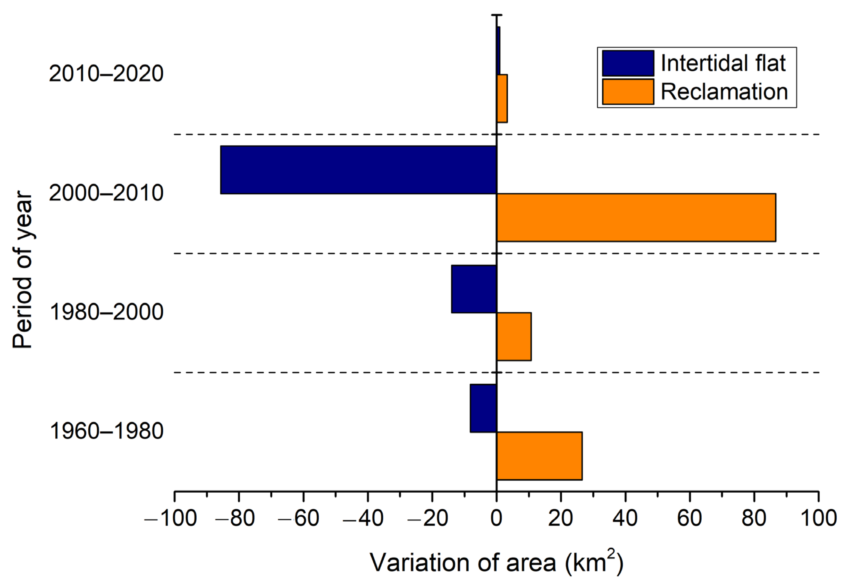
4.1. Process of Coastal Reclamations

The coastlines were extracted from the remote sensing images (Figure 2). Since 1960, coastlines have migrated seaward because of coastal reclamation. Coastal reclamation occurred on the intertidal flats at the bay mouth. Especially in secondary bays between rocky headlands, broad intertidal flats that are favorable for coastal reclamation have developed. Consequently, the width between the northern and southern banks decreased, and some islands near the bank were connected with the land by reclamations.
The area of coastal reclamation was calculated at 10-year intervals between 1960 and 2020 (Table 2). There were two periods of high-intensity coastal reclamation. The first was between 2000 and 2010, with an area of 86.625 km2 reclaimed, accounting for 68.12% of the total area (127.166 km2) between 1960 and 2020. The second was in the 1960s, when coastal reclamation covered parts of intertidal flats on both the northern and southern banks, with an area of 25.293 km2, accounting for 19.89% of the total area. Coastal reclamation was locally distributed on intertidal flats, with low intensity in the 1970s, 1980s, 1990s, and 2010s.

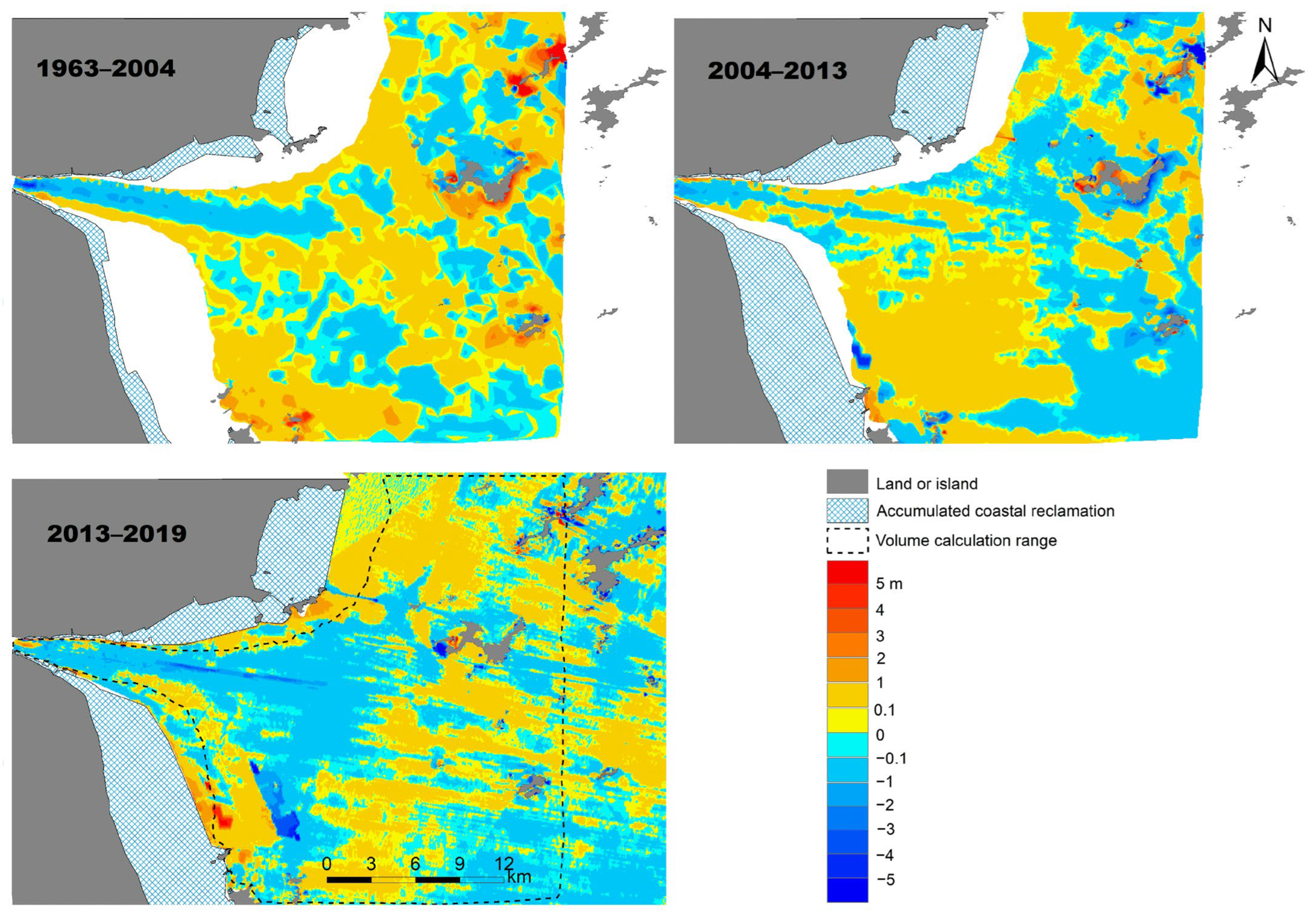
4.2. Topographic Changes in Taizhou Bay

Coastal reclamation occupied the upper part of intertidal flats, causing a decrease in the intertidal flat area (Figure 3). This area was calculated between the coastline and the 0 m isobath. As shown in Table 3, this area was 175.102 km2 in 1963 and decreased continuously to 67.285 km2 in 2013. In particular, it decreased by 85.7 km2 between 2004 and 2013, accounting for 79.5% of the total reduced area between 1963 and 2013. This area presented the opposite trend between 2013 and 2019 and increased by approximately 1 km2.
Bathymetric data surveyed in 1963, 2004, 2013, and 2019 were selected to analyze topographic changes from 1963 to 2019. As shown in Figure 4, the main channel of the bay experienced continuous erosive changes during this period. There was an obvious erosion area in the main channel at the top of the bay, with vertical erosion magnitudes exceeding 3 m between 1963 and 2004. This erosional area tended to migrate from the top to the mouth of the bay over time. This trend is also depicted in Figure 3. The water depth at the mouth was less than 2 m before 2004. It became more than 2 m in 2004 and grew deeper in 2013 and 2019. The main channel (deeper than 2 m) at the mouth has been connected with the deep-water area outside the mouth since 2004, and it has become deeper and wider.
There developed gentle subaqueous shore slopes on both the southern and northern sides of the mouth during the study period. They were connected with the intertidal flats upwards and transited to the open sea downwards. Accumulation occurred in the upper part of the shore slope. As shown in Figure 3, the depth contours of this region migrated seaward. This region silted up by approximately 0~1 m during each of the three periods of 1963–2004, 2004–2013, and 2013–2019 (Figure 4). Erosion and siltation exceeded 3 m in the local area of this region on the southern side between 2013 and 2019. The erosion and accumulation areas were patchy in the lower part of the shore slope, and the magnitude of change was 0~1 m during each of these three periods.
According to the common coverage area of the bathymetric data in different periods, the calculation range of volume in Taizhou Bay was delimited (Figure 4). The calculation results revealed that this volume was 2728.427 × 106 m3 in 1963, which was the maximum value during the study period. It decreased to 2631.121 × 106 m3 in 2004 and then increased slightly in 2013 and 2019 (Table 3). The mean water depth was also calculated for this area, from which the annual rate of erosion or accumulation was calculated. The accumulation rate was 0.4 cm/a between 1963 and 2004, and the erosion rate was 1 cm/a between 2004 and 2013, and 1.7 cm/a between 2013 and 2019.
Two cross-sections were selected on both the southern and northern sides of the mouth (Figure 1). Cross-sectional topographic data points were retrieved from the DEMs. As shown in Figure 5, the typical cross-sectional topography can be approximately divided into four segments. The uppermost segment is the intertidal flat with water depth being less than 0 m, followed downwards by the upper part of the subaqueous shore slope, the slope break, and the lower part of the subaqueous shore slope. The magnitude of erosion or accumulation was less than 0.2 m during each period at the slope break, and it gradually increased upwards and downwards. The accumulation occurred at the intertidal flat and the upper part of the subaqueous shore slope in both sections from 1963 to 2019. Accumulation and erosion occurred at the lower part of the subaqueous shore slope in the P1 and P2 sections, respectively, between 2004 and 2019. The accumulation caused the water depth of the P1 section to decrease by approximately 0~2 m. The magnitude of erosion or accumulation was about 0~0.5 m in the P2 section. Moreover, a scouring hole approximately 2~3 m deep occurred in the upper part of the subaqueous shore slope of the P2 section between 2013 and 2019, as shown in Figure 4.

5. Discussion

5.1. Effects of Coastal Reclamation on Topographic Changes

Coastal reclamation occupied a portion of the intertidal flats, which could be the primary factor influencing topographic changes in Taizhou Bay during the last few decades. It has occurred during every 10-year period since the 1960s (Figure 2). The area of coastal reclamation was 127.166 km2 between 1960 and 2020, and the annual area was 2.119 km2 (Table 2). Extensive coastal reclamation obviously decreases the tidal prism in a macrotidal bay or estuary, which results in changes in tidal asymmetry. This hydrodynamic mechanism causes net sediment transport into the bay or estuary, which results in siltation of the bay or estuary. Siltation induced by coastal reclamation has been documented in some estuaries and bays [27,28,29,30]. This siltation also occurred in Taizhou Bay. The subaqueous volume of the bay decreased by 97.306 × 10⁶ m3, and the accumulation rate was 0.4 cm/a between 1963 and 2004 (Table 3). Large-scale reclamation occurred between 2000 and 2010, resulting in obvious accumulation at the upper part of the subaqueous shore between 2004 and 2013 (Figure 5). The simulation results of the hydrodynamic numerical model revealed that the tidal prism of Taizhou Bay decreased after large-scale coastal reclamation [31]. Moreover, the maximum velocities of the flood and ebb currents decreased significantly around the reclamation area. Therefore, fine sediment could accumulate at the intertidal flat and the upper part of the subaqueous shore under the control of the hydrodynamic mechanism mentioned above.
Coastal reclamation also altered the geometry of Taizhou Bay, which was reflected in the narrowing of its width and the increasing of its length. The narrowing of the width reduced the cross-sectional width and caused an increase in the maximum flood current velocity in the main channel. This may be the hydrodynamic mechanism that caused continuous flushing of the main channel (Figure 4). Reclamation occurring on open coasts also caused the estuary to extend seaward. The originally open sea narrowed, where the flood current velocity increased. This change in current velocity was proven by the model simulation in Taizhou Bay [13]. Therefore, the eastern end of the main channel continued to expand eastwards as the estuary extended seaward. Since 2004, the main channel at the mouth has connected with the deep-water area outside the mouth, and it has become deeper and wider. However, the area of coastal reclamation was only 11.951 km2 between 1970 and 2000, when the bay experienced siltation. To maintain the depth of the main channel for navigation, channel dredging works have been carried out in the Jiaojiang River estuary. The estuary was dredged at an annual rate of approximately 0.1 m/a [24]. Coastal reclamation and channel dredging are the two main causes of continuous flushing of the main channel. As coastal reclamation continued, fine-grained sediment from adjacent mudflats was pumped into the reclaimed area, which resulted in significant localized scouring of the southern mudflats between 2013 and 2019 (Figure 4 and Figure 5).

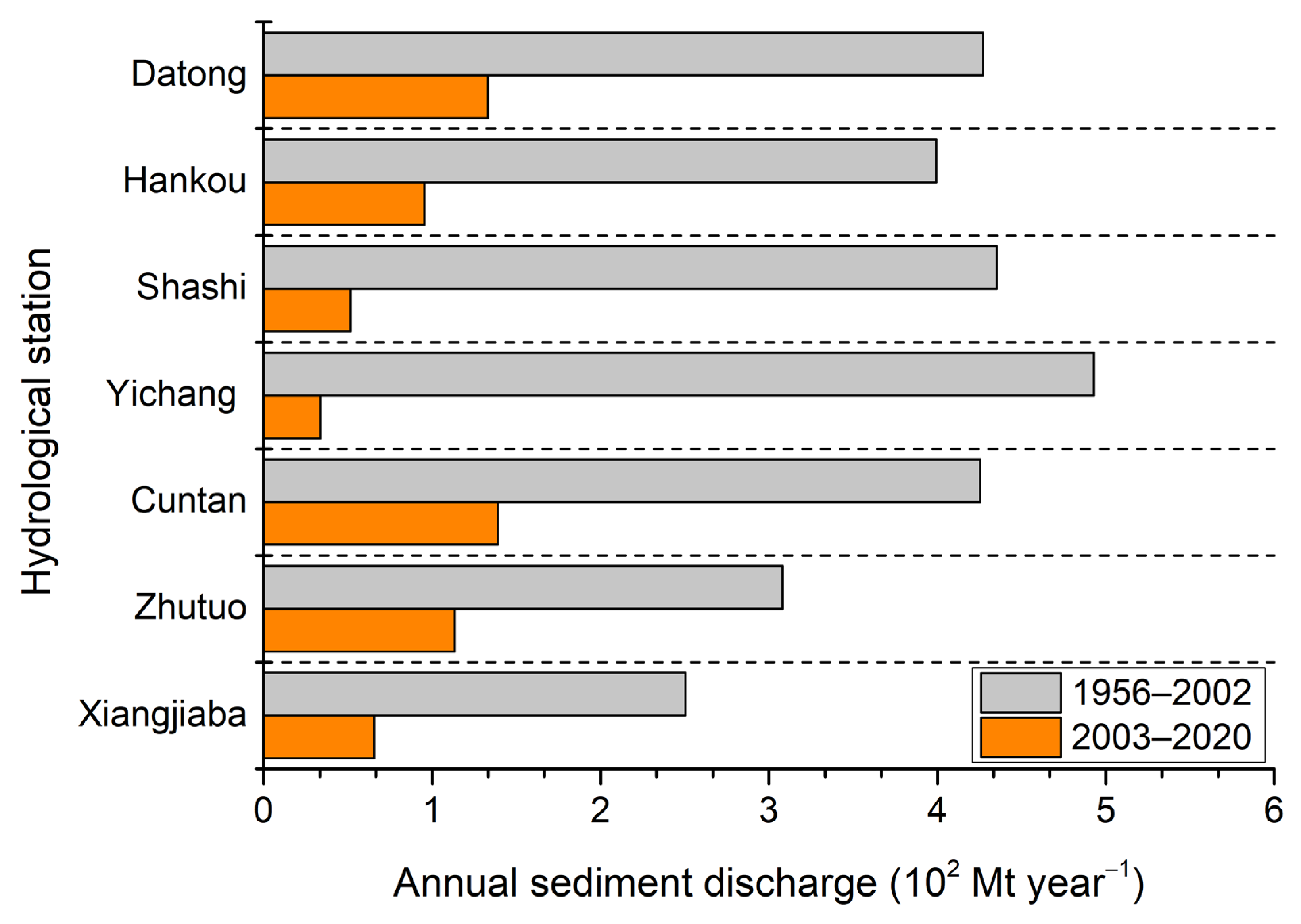
5.2. Influence of the Decreasing Supply of Sediment

The sediment into Taizhou Bay was derived from three sources, including the sediment load of the Changjiang River, the sediment load of the Jiaojiang River, and resuspended sediment in the inner shelf [15]. Most fine-grained sediment came from coastal waters and originated from the Changjiang River [23]. Owing to the interception of reservoirs in the upper reaches of the river, the amount of sediment entering the middle and lower reaches has decreased over the last few decades [26]. An abrupt reduction occurred in 2003 when the Three Gorges Dam was put into operation. Abundant sediment was trapped by the dam, which resulted in a 68.62~92.91% reduction in annual sediment discharge observed at hydrological stations downstream of the dam after 2003 (Figure 6).
The sharp decrease in incoming sediment from the upper reaches has caused riverbed erosion in the middle and lower reaches of the Changjiang River [32,33]. The eroded sediment was not sufficient to compensate for the reduction in sediment entering the sea. Gao et al. (2018) noted that reservoir emplacement currently reduced the sediment load towards the East China Sea by 453 Mt year−1 in the Changjiang River [34]. The Changjiang subaqueous delta shifted the morphodynamic patterns rapidly from accumulation to erosion within a short period of time after 2003 [35]. The supply of sediment to Zhejiang inner-shelf mud and Fujian inner-shelf mud may also decrease accordingly [36]. Liu et al. (2021) reported that there was a good relationship between the variation in extremely fine-grained sediment deposited on the Zhejiang and Fujian coasts and the stepwise reduction in the sediment load of the Changjiang River entering the sea [37]. Indeed, this response relationship was characterized by spatial and temporal variations reflected in the weakening of the response intensity and increase in response time from the northern to southern coasts.
The decrease in sediment deposition in the study area of Taizhou Bay after the construction of the Three Gorges Dam may be correlated with the abrupt reduction in sediment supply from the Changjiang River. Taizhou Bay is located south of the Zhejiang coast, and the lag time was approximately 10–14 years, when the reduction in the sediment load from the Changjiang River began to affect the sediment supply to this bay [37]. As shown in Table 3, both the subaqueous volume and mean water depth increased between 2004 and 2013, and this trend continued between 2013 and 2019. The timing of the reduction in sediment deposition in the bay was generally consistent with the lag time. Reclamation continued to occur between 2004 and 2020, while the volume and the mean water depth changed from decreasing to increasing, and the decrease in sediment supply may be an important reason for this. River damming causing coastal erosion outside the estuary has also been reported in the Paraíba do Sul River, Southeast Brazil [38]. To confirm this mechanism, a series of future studies are needed, including changes in the amount of sediment imported into and exported out of Taizhou Bay over the last two decades, and the simulation of the relationship between the reduction in sediment supply and spatio-temporal change in the topography of Taizhou Bay. The weighting of the effects of proximal anthropogenic-induced sand reduction versus distal sediment supply reduction on scouring in Taizhou Bay also requires further research.

5.3. Feedback Mechanism between Morphological Evolution and Coastal Reclamation

A wide intertidal flat has developed on both the northern and southern banks of Taizhou Bay, where extensive coastal reclamation has occurred (Figure 2). Coastal reclamation occupied the upper part of the intertidal flat, causing a reduction in its area and width. This could promote negative feedback on the morphological evolution of the intertidal flat to maintain the convex profile shape with an adjustment of the width or slope [39]. Meanwhile, this feedback could cause seaward expansion of the intertidal flat outer boundary [40]. When coastal reclamation occurred within a semi-enclosed tidal basin, this feedback could be used to interpret the siltation of the bay under the influence of coastal reclamation [11,40]. For open coasts, this feedback could maintain the accretion of the intertidal flat by landward transport of sediment, with the result that the intertidal flat became narrower and steeper following extensive coastal reclamation [39,41]. This accretion of intertidal flats was also found on both the northern and southern banks of Taizhou Bay during the study period. Moreover, accretion occurred on the upper part of the subaqueous shore slope, which has rarely been reported in previous studies. Changes in siltation could cause the outer boundary of the intertidal flat to expand seaward, which results in the widening of its width. Could this widening compensate for the narrowing of width caused by the occupation of coastal reclamation?
Here, variations in the area and width of the reclaimed region and intertidal flat were analyzed. As shown in Figure 7, coastal reclamation was the main cause of intertidal flat area reduction. Indeed, the decreased area of the intertidal flat was smaller than the increased area of reclamation. A negative feedback process occurred, but the intertidal flat area was not restored to that before reclamation on a 20-year time scale. This characteristic was also reflected in the variation in the width of the intertidal flat. As shown in Table 4, coastal reclamation occurred between 1960 and 1970, causing the width of the intertidal flat to decrease by 645 m in the P2 section. Under the negative feedback mechanism, the intertidal flat expanded slowly seaward between 1970 and 2000, when only small-scale reclamation occurred. The width of the intertidal flat increased by 265 m in the P2 section. This trend is also reflected in the P1 section. If reclamation did not occur between 2000 and 2010, this seaward expansion was likely to continue. The intertidal flat may be restored to its pre-reclamation width with adequate sediment supply after a long period. Because coastal reclamation has been gradual, this complete restoration process cannot be captured by topographic survey data. Numerical simulation methods can be used to model the extent and timescale of this restoration in the future.

6. Conclusions

Gradual coastal reclamation has occurred in Taizhou Bay since 1960. Reclamation has occupied tidal flats, changed the geometry of coastal boundaries, and influenced the topography of the bay. As a dominant factor, reclamation has caused siltation in the bay over the last five decades, which has occurred mainly on the mudflats and shore slopes. Reclamation has also caused the estuary to narrow laterally and expand longitudinally seaward, leading to scouring of the main channel. However, siltation turned into a feature dominated by erosion in the last decade. This shift may have been caused by a drastic reduction in sediment supply after the Three Gorges Dam was put into operation. A negative feedback process exists between seaward tidal flat expansion and coastal reclamation. The compensatory expansion of tidal flats is a much slower process than the advance of reclamation to the sea. The extent and timescale of this restoration need to be researched in the future.

Author Contributions

Y.L.: writing—original draft preparation, writing—review and editing. X.X.: conceptualization, formal analysis. T.C.: methodology, data curation. X.W.: software, data curation. J.Z.: data curation. All authors have read and agreed to the published version of the manuscript.

Funding

This research was funded by the Zhejiang Provincial Natural Science Foundation of China, grant number LDT23D06025D06.

Data Availability Statement

The original contributions presented in the study are included in the article. Further inquiries can be directed to the corresponding author.

Acknowledgments

Reviewers and the academic editor are thanked for their valuable and constructive comments in improving the overall quality of the work.

Conflicts of Interest

The authors declare no conflict of interest.

References

  1. Allen, J.R.L. Morphodynamics of Holocene salt marshes: A review sketch from the Atlantic and Southern North Sea coasts of Europe. Quat. Sci. Rev. 2000, 19, 1155–1231. [Google Scholar] [CrossRef]
  2. Studds, C.E.; Kendall, B.E.; Murray, N.J.; Wilson, H.B.; Rogers, D.I.; Clemens, R.S.; Gosbell, K.; Hassell, C.J.; Jessop, R.; Melville, D.S.; et al. Rapid population decline in migratory shorebirds relying on Yellow Sea tidal mudflats as stopover sites. Nat. Commun. 2017, 8, 14895. [Google Scholar] [CrossRef] [PubMed]
  3. Barbier, E.B.; Hacker, S.D.; Kennedy, C.; Koch, E.W.; Stier, A.C.; Silliman, B.R. The value of estuarine and coastal ecosystem services. Ecol. Monogr. 2011, 81, 169–193. [Google Scholar] [CrossRef]
  4. Wang, J.; Dai, Z.; Mei, X.; Fagherazzi, S. Tropical cyclones significantly alleviate mega-deltaic erosion induced by high riverine flow. Geophys. Res. Lett. 2020, 47, e2020GL089065. [Google Scholar] [CrossRef]
  5. Kremer, H.H.; Le Tissier, M.D.A.; Burbridge, P.R.; Talaue-Mcmanus, L.; Rabalais, N.N.; Parslow, J.; Crossland, C.J.; Young, B. Land-Ocean Interactions in the Coastal Zone: Science Plan and Implementation Strategy; IGBP Report 51/IHDP Report 18; IGBP Secretariat: Stockholm, Sweden, 2005; pp. 1–68. [Google Scholar]
  6. Van Maren, D.S.; Oost, A.P.; Wang, Z.B.; Vos, P.C. The effect of land reclamations and sediment extraction on the suspended sediment concentration in the Ems Estuary. Mar. Geol. 2016, 376, 147–157. [Google Scholar] [CrossRef]
  7. Murray, N.J.; Worthington, T.A.; Bunting, P.; Duce, S.; Hagger, V.; Lovelock, C.E.; Lucas, R.; Saunders, M.I.; Sheaves, M.; Spalding, M.; et al. High-resolution mapping of losses and gains of Earth’s tidal wetlands. Science 2022, 376, 744–749. [Google Scholar] [CrossRef]
  8. Murray, N.J.; Phinn, S.R.; DeWitt, M.; Ferrari, R.; Johnston, R.; Lyons, M.B.; Clinton, N.; Thau, D.; Fuller, R.A. The global distribution and trajectory of tidal flats. Nature 2019, 565, 222–225. [Google Scholar] [CrossRef]
  9. Friedrichs, C.T.; Aubrey, D.G. Non-linear tidal distortion in shallow well-mixed estuaries: A synthesis. Coast. Shelf Sci. 1988, 27, 521–545. [Google Scholar] [CrossRef]
  10. Speer, P.E.; Aubrey, D.G. A study of non-linear tidal propagation in shallow inlet/estuarine systems Part II: Theory. Estuar. Coast. Shelf Sci. 1985, 21, 207–224. [Google Scholar] [CrossRef]
  11. Jia, J.J.; Gao, S.; Xue, Y.C. Sediment dynamic processes of the Yuehu inlet system, Shandong Peninsula, China. Estuar. Coast. Shelf Sci. 2003, 57, 783–801. [Google Scholar] [CrossRef]
  12. ECCHE (Editorial Committee for Chinese Harbours and Embayments). Chinese Harbours and Embayments (Part VI); China Ocean Press: Beijing, China, 1993; pp. 43–46. (In Chinese) [Google Scholar]
  13. Guo, C. Response of Jiaojiang Estuary to Coastal Reclamation; Zhejiang University: Hangzhou, China, 2016; pp. 67–90, (In Chinese with English Abstract). [Google Scholar]
  14. Li, B.G.; Wang, C.H.; Zhou, H.Q.; Wu, X.Y.; Yang, H. Adjustment mechanism on the erosion and accretion of riverbed in the Jiaojiang Estuary in Zhejiang Province, China. Acta Oceanol. Sin. 2009, 31, 89–100, (In Chinese with English Abstract). [Google Scholar]
  15. Xie, Q.C.; Zhang, L.R.; Li, B.G. Analysis of accumulation in the Taizhou Bay. Donghai Mar. Sci. 1988, 6, 25–33, (In Chinese with English Abstract). [Google Scholar]
  16. Mai, M.; Yan, Y.; Wu, Y.X. Analysis on hydrographical environment and seabed morphological processes characteristics in Taizhou Bay. J. Waterw. Habor 2009, 30, 246–252, (In Chinese with English Abstract). [Google Scholar]
  17. Milliman, J.D.; Shen, H.T.; Yang, Z.S.; Meade, R.H. Transport and deposition of river sediment in the Changjiang estuary and adjacent continental shelf. Contin. Shelf Res. 1985, 4, 37–45. [Google Scholar] [CrossRef]
  18. Xie, D.F.; Pan, C.H.; Wu, X.G.; Gao, S.; Wang, Z.B. Local human activities overwhelm decreased sediment supply from the Changjiang River: Continued rapid accumulation in the Hangzhou Bay-Qiantang Estuary system. Mar. Geol. 2017, 392, 66–77. [Google Scholar] [CrossRef]
  19. Li, Y.; Wolanski, E.; Xie, Q.C. Coagulation and settling of suspended sediment in the Jiaojiang River Estuary, China. J. Coast. Res. 1993, 9, 390–402. [Google Scholar]
  20. Bi, A.H.; Sun, Z.L. A preliminary study on the estuarine processes in the Jiaojiang River, China. J. Sediment. Res. 1984, 3, 12–26, (In Chinese with English Abstract). [Google Scholar]
  21. Dong, L.X.; Wolanski, E.; Li, Y. Field and modeling studies of fine sediment dynamics in the extremely turbid Jiaojiang River estuary, China. J. Coast. Res. 1997, 13, 995–1003. [Google Scholar]
  22. Zhu, Y.K. Some characteristics of stream-like macro-tidal estuary (Jiaojiang). Geogr. Study 1986, 5, 21–29, (In Chinese with English Abstract). [Google Scholar]
  23. Guan, W.B.; Kot, S.C.; Wolanski, E. 3-D fluid-mud dynamics in the Jiaojiang Estuary, China. Estuar. Coast. Shelf Sci. 2005, 65, 747–762. [Google Scholar] [CrossRef]
  24. Guan, W.B.; Wolanski, E.; Dong, L.X. Cohesive sediment transport in the Jiaojiang River estuary, China. Estuar. Coast. Shelf Sci. 1998, 46, 861–871. [Google Scholar] [CrossRef]
  25. Fu, N.P.; Bi, A.H. Discussion on the problems in the sediment transport of the Jiaojiang River. J. Sediment. Res. 1989, 8, 51–57, (In Chinese with English Abstract). [Google Scholar]
  26. Hu, Q.H.; Zhang, X.M. New pattern of river evolution and systematic protection and governance in China. China Water Resour. 2024, 7, 1–8, (In Chinese with English Abstract). [Google Scholar]
  27. Dai, Z.J.; Fagherazzi, S.; Mei, X.F.; Chen, J.Y.; Meng, Y. Linking the infilling of the North Branch in the Changjiang (Yangtze) estuary to anthropogenic activities from 1958 to 2013. Mar. Geol. 2016, 379, 1–12. [Google Scholar] [CrossRef]
  28. Wei, W.; Dai, Z.J.; Mei, X.F.; Liu, J.P.; Gao, S.; Li, S.S. Shoal morphodynamics of the Changjiang (Yangtze) estuary: Influences from river damming, estuarine hydraulic engineering and reclamation projects. Mar. Geol. 2017, 386, 32–43. [Google Scholar] [CrossRef]
  29. Zhao, J.; Guo, L.C.; He, Q.; Wang, Z.B.; van Maren, D.S.; Wang, X.Y. An analysis on half century morphological changes in the Changjiang Estuary: Spatial variability under natural processes and human intervention. J. Mar. Syst. 2018, 181, 25–36. [Google Scholar] [CrossRef]
  30. Gao, G.D.; Wang, X.H.; Bao, X.W.; Song, D.H.; Lin, X.P.; Qiao, L.L. The impacts of land reclamation on suspended-sediment dynamics in Jiaozhou Bay, Qingdao, China. Estuar. Coast. Shelf Sci. 2018, 206, 61–75. [Google Scholar] [CrossRef]
  31. Zhang, Q.; Tao, J.F.; Zhang, C.K.; Dai, W.Q.; Xu, F. Effect of large-scale reclamation of tidal flats on the hydrodynamic characteristics in the Taizhou Bay. Mar. Sci. Bull. 2015, 34, 392–398. [Google Scholar]
  32. Hu, Q.H.; Fang, C.M.; Shi, H.L. Recent progress in sediment research of the Three Gorges Project. China Water Resour. 2023, 19, 10–16, (In Chinese with English Abstract). [Google Scholar]
  33. Gao, J.H.; Jia, J.J.; Wang, Y.P.; Yang, Y.; Li, J.; Bai, F.L.; Zou, X.Q.; Gao, S. Variations in quantity composition and grain size of Changjiang sediment discharging into the sea in response to human activities. Hydrol. Earth Syst. 2015, 19, 645–655. [Google Scholar] [CrossRef]
  34. Gao, J.H.; Jia, J.J.; Kettner, A.J.; Xing, F.; Wang, Y.P.; Li, J.; Bai, F.L.; Zou, X.Q.; Gao, S. Reservoir-induced changes to fluvial fluxes and their downstream impacts on sedimentary processes: The Changjiang (Yangtze) River, China. Quat. Int. 2018, 493, 187–197. [Google Scholar] [CrossRef]
  35. Gao, J.H.; Shi, Y.; Sheng, H.; Kettner, A.J.; Yang, Y.; Jia, J.J.; Xing, F.; Wang, Y.P.; Li, J.; Chen, Y.N.; et al. Rapid response of the Changjiang (Yangtze) River and East China Sea source-to-sink conveying system to human induced catchment perturbations. Mar. Geol. 2019, 414, 1–17. [Google Scholar] [CrossRef]
  36. Jia, J.J.; Gao, J.H.; Cai, T.L.; Li, Y.; Yang, Y.; Wang, Y.P.; Xia, X.M.; Li, J.; Wang, A.J.; Gao, S. Sediment accumulation and retention of the Changjiang (Yangtze River) subaqueous delta and its distal muds over the last century. Mar. Geol. 2018, 401, 2–16. [Google Scholar] [CrossRef]
  37. Liu, S.J.; Gao, J.H.; Xu, X.M.; Shi, Y.; Shu, Z.; Wu, H.; Yuan, B.Y.; Jia, J.J. Response of sediment grainsize composition of the Zhe-Min coastal mud to the sediment load reduction of the Changjiang River entering the sea. Haiyang Xuebao 2021, 43, 105–115, (In Chinese with English Abstract). [Google Scholar] [CrossRef]
  38. Lämmle, L.; Perez Filho, A.; Donadio, C.; Arienzo, M.; Ferrara, L.; Santos, C.d.J.; Souza, A.O. Anthropogenic Pressure on Hydrographic Basin and Coastal Erosion in the Delta of Paraíba do Sul River, Southeast Brazil. J. Mar. Sci. Eng. 2022, 10, 1585. [Google Scholar] [CrossRef]
  39. Wang, Y.P.; Gao, S.; Jia, J.J.; Thompson, C.E.L.; Gao, J.H.; Yang, Y. Sediment transport over an accretional intertidal flat with influences of reclamation, Jiangsu coast, China. Mar. Geol. 2012, 291–294, 147–161. [Google Scholar] [CrossRef]
  40. Liu, Y.F.; Xia, X.M.; Wang, X.K.; Cai, T.L.; Zheng, J. Human-induced rapid siltation within a macro-tidal bay during past decades. Front. Mar. Sci. 2024, 11, 1325003. [Google Scholar] [CrossRef]
  41. Wu, W.T.; Zhang, M.; Chen, C.P.; Chen, Z.Q.; Yang, H.F.; Su, H. Coastal reclamation shaped narrower and steeper tidal flats in Fujian, China: Evidence from time-series satellite data. Ocean Coast. Manag. 2024, 247, 106933. [Google Scholar] [CrossRef]
Figure 1. Chart of the study area: (a) location map of Taizhou Bay; (b) map of bathymetry, marine boundary of the study area, and location of bathymetric sections. The study area can be divided into three parts: I and II denote the shoal-slope areas on the northern and southern sides of the mouth, respectively; III denotes the main channel area.
Jmse 12 01744 g001
Figure 2. The coastlines were extracted from remote sensing images, and the change in coastal reclamation is plotted, according to the change of coastlines.
Jmse 12 01744 g002
Figure 3. Range of intertidal flats and subaqueous topography during the six periods. The blank areas denote no bathymetric data.
Jmse 12 01744 g003
Figure 4. Morphological changes over successive periods: 1963–2004, 2004–2013, and 2013–2019. The blank areas denote no bathymetric data.
Jmse 12 01744 g004
Figure 5. Typical cross-sectional topography changes on both banks of the mouth. The dashed lines are dividing lines between the four segments of the shore slope: a: intertidal flat; b: upper part of the subaqueous shore slope; c: slope break; d: lower part of the subaqueous shore slope.
Jmse 12 01744 g005
Figure 6. Annual sediment discharge observed at hydrological stations downstream of the Three Gorges Dam (Data source: Hu and Zhang, 2024 [26]).
Jmse 12 01744 g006
Figure 7. Area changes in coastal reclamation and intertidal flats over successive periods.
Jmse 12 01744 g007
Table 1. Bathymetric data and remote sensing data collected and used in this study.
Data TypeData Format/
Sensor
DateScale/
Resolution
Coordinate SystemDatumSource
Bathymetric dataPaper chart19631:50,000BJ1954TLTLSea Chart
Paper chart19701:30,000BJ1954TLTLSea Chart
Paper chart19831:50,000BJ1954Huanghai Vertical Datum (1956)SIOSOA
Paper chart20041:30,000WGS-84TLTLSea Chart
Digital data20131:10,000CGCS2000TLTLDNRZP
Digital data20191:10,000CGCS2000TLTLDNRZP
Remote sensing dataKH-4A1964/12/212.7 m//USGS
KH-4A1970/12/62.7 m//USGS
KH-4A1980/9/122.7 m//USGS
Landsat 5 TM1990/3/730 mWGS-84/GSCloud
Landsat 5 TM2000/2/1530 mWGS-84/GSCloud
Landsat 5 TM2010/11/930 mWGS-84/GSCloud
Aerial photograph20200.5 mCGCS2000/DNRZP
Note: ① SIOSOA: Second Institute of Oceanography, State Oceanic Administration. ② DNZRP: Department of Natural Resources of Zhejiang Province.
Table 2. Variations in the area of coastal reclamation (area unit: km2).
PeriodArea of ReclamationsAnnual Average Area% of Total Area Reclaimed
1960–197025.2932.25919.89%
1970–19801.2800.1281.01%
1980–19905.2720.5274.14%
1990–20005.3990.5404.25%
2000–201086.6258.66368.12%
2010–20203.2970.3302.59%
1960–2020127.1662.119100%
Table 3. Characteristics of subaqueous volume, mean water depth, and intertidal flat area.
YearIntertidal Flat Area
(km2)
Subaqueous Volume
(×106 m3)
Mean Water Depth
(m)
1963175.1022728.4274.54
1980166.972//
2004152.9852631.1214.38
201367.2852633.9374.47
201968.2322681.7254.57
Table 4. Changes in the width of coastal reclamation and intertidal flat at typical cross-sections.
Reclamation Width (m)Intertidal Flat Width (m)
Period of YearP1P2YearP1P2
1960–19701560410196071107155
1970–1980001970/6510
1980–199000198060106595
1990–200001001990//
2000–201032254880200061806775
2010–202000201028602310
202030102055
Disclaimer/Publisher’s Note: The statements, opinions and data contained in all publications are solely those of the individual author(s) and contributor(s) and not of MDPI and/or the editor(s). MDPI and/or the editor(s) disclaim responsibility for any injury to people or property resulting from any ideas, methods, instructions or products referred to in the content.

