Article

Identification of Complex Multi-Vessel Encounter Scenarios and Collision Avoidance Decision Modeling for MASSs

1
Navigation College, Dalian Maritime University, Dalian 116026, China
2
Dalian Key Laboratory of Safety & Security Technology for Autonomous Shipping, Dalian 116026, China
3
China Ship Scientific Research Center, Wuxi 214082, China
4
Taihu Laboratory of Deepsea Technological Science, Wuxi 214082, China
*
Authors to whom correspondence should be addressed.
J. Mar. Sci. Eng. 2024, 12(8), 1289; https://doi.org/10.3390/jmse12081289
Submission received: 22 June 2024 / Revised: 27 July 2024 / Accepted: 29 July 2024 / Published: 31 July 2024
(This article belongs to the Section Ocean Engineering)

Abstract

:
Complex multi-vessel encounter situations are a challenging problem for ships to avoid collisions, and the International Regulations for Preventing Collision at Sea, 1972 (COLREGs) do not provide a clear delineation of multi-vessel encounter situations and the responsibility of collision avoidance (CA). Furthermore, Marine Autonomous Surface Ships (MASS), which realize autonomous navigation functions, face the problem of recognizing complex multi-ship encounter situations and the corresponding CA decisions. In this study, we adopt the velocity obstacle (VO) algorithm to visualize and identify the danger of multi-ship encounters with the own ship (OS) as the first viewpoint. Additionally, we consider the motion changes in target ships (TSs) and their possible CA behaviors as the basis of the ship’s CA decision-making. According to COLREGs, a simplified method for classifying the encounter situations of multiple clustered ships is proposed, considering the coupling of collision hazards and CA responsibilities between related TSs. On this basis, the corresponding CA decisions for each classified situation are proposed, and a large number of simulation experiments are conducted based on the proposed method by considering the three-ship and four-ship encounter model in the Imazu problem as an example. The experimental results indicate that the proposed method can effectively recognize the complex multi-ship encounter situation in the Imazu problem, and it can adjust the CA measures of the OS in time according to the COLREGs and the behavior of TSs. This provides the basis and reference for MASS when facing complex multi-ship encounter situations.

1. Introduction

1.1. Research Significance

In recent years, with the increasing development of maritime transportation, the rate of maritime accidents has been increasing on an annual basis, especially the number of collisions. The European Maritime Safety Agency (EMSA) released an annual overview of marine accidents and incidents in 2022, in which a total of 4869 collision accidents and groundings occurred from 2014 to 2022. This accounted for 45.8% of the total number of accidents. The percentage of accidents whose causes were human factors was 59.1% [1], including inadequate lookout, unclear perception of responsibility, incorrect judgment of ship encounter hazards, or decision-making that did not comply with the International Regulations for Preventing Collisions at Sea, 1972 (COLREGs). The main cause of collision accidents by human action in a multi-ship encounter situation is that the ship’s officer of the watch (OOW) does not understand the situation clearly and is unable to judge the ship’s responsibility [2,3,4]. Therefore, the collision avoidance strategy is not timely and effective [5]. In an existing study [6], a case of a multi-ship collision was reported. In this case, an LPG ship was in a multi-ship encounter situation, forming a continuous pair of encounters with two vessels each, and took inappropriate action, which led to a collision with a tugboat. The maritime navigation environment is complex, and multi-ship encounters are inevitable in coastal waters. Vessel autonomous collision avoidance (CA) decision-making must be able to cope with multi-ship encounters appropriately before it can be truly used in nautical practice. Furthermore, this is applicable to manned vessels.
Hence, the study of the decision-making model in complex multi-ship encounter situations is highly significant. This can be manifested by the following:
(1)
It is conducive to the expansion of the provisions of the COLREGs and promotes manned and unmanned vessels to reach a consensus on CA decision-making. Furthermore, it clarifies their respective responsibilities and obligations and then takes effective CA actions.
(2)
It is conducive to exploring the division mechanism of multi-ship encounter situations, enhancing the cognitive ability of intelligent ships to recognize complex encounters. Furthermore, it provides a reference and basis for the decision-making process for the autonomous navigation of ships.
(3)
Intelligent algorithm testing should be supported by representative scenarios, and standardized, typical scenarios are of great significance to algorithm testing. The refinement of standard, typical scenes differs from the completeness test based on probability statistics, which should be highly generalized and representative. Furthermore, it should be based on the difficult scenarios of complex multi-ship encounters, drawing on practical nautical experience.
(4)
In-depth understanding of the risk and feasible strategy space of each ship in a multi-ship encounter situation can reduce the risk of collision due to human factors and ensure the safety of ship navigation.

1.2. Multi-Ship Encounter Situation—The Challenge of Ship Collision Avoidance

Rule 5 of the COLREGs emphasizes the necessity for every ship to maintain a vigilant lookout at all times to assess the situation and the risk of collision adequately. The term “situation” in the COLREGs often pertains to close-quarters situations, including those notably mentioned in Rule 8, “Actions to avoid collision”, and Rule 19, “Rules for the action of ships in case of poor visibility”. Additionally, Section II of the COLREGs, “Rules for the action of ships in mutual encounter”, specifically covers the head-on and crossing situations. However, the term “situation” is not used for “Overtaking”. While the COLREGs primarily address two-ship encounters, multi-ship encounters are frequent in practice, necessitating a global perspective. This is underscored by Rule 2, “Responsibility”, paragraph (b), which states: “In construing and complying with these Rules due regard shall be had to all dangers of navigation and collision and to any special circumstances, including the limitations of the vessels involved, which may make a departure from these Rules necessary to avoid imminent danger”. These highlight the complexity and critical nature of collision avoidance in multi-ship situations. Decision-making in such situations poses significant challenges for both human operators and autonomous collision avoidance actions, particularly in the following aspects:
(1)
COLREGs do not have clear regulations about multi-ship encounter situations.
(2)
On manned and unmanned large vessels, different vessel officers and algorithms produce different feasible solutions. However, the optimal solution is difficult to determine in practice.
(3)
The coupling of multi-ship encounters is very high, whereas the decoupling is difficult. A give-way ship in a two-ship encounter situation can be a stand-on ship in another situation formed at the same time.

1.3. Factors Affecting CA Decisions in Complex Encounters

1.3.1. Collision Risk

The risk of collision is dynamic, involving both potential and direct risks. Potential risk arises from future actions that target ships (TSs) might take. If a target ship maintains its original navigation state, the risk of collision with the own ship (OS) can vary significantly in urgency and magnitude. A primary challenge in assessing collision risk is the diversity of factors that contribute to such risk. The Collision Risk Index (CRI), which ranges from 0 to 1, serves as a crucial metric for determining whether a ship should initiate CA behavior [7]. Commonly, the distance to closest point of approach (DCPA) and time to closest point of approach (TCPA) are utilized to evaluate this risk [8]. Xie et al. developed a model for calculating ship collision risk that considers both time and space dimensions [9]. Currently, various methods are employed to compute the CRI, including fuzzy set theory, neural networks, and reinforcement learning, which integrate multiple factors. Namgung et al. [10] and Sarhadi et al. [11] proposed a fuzzy set theory-based model to assess ship collision risk, considering five factors: DCPA, TCPA, relative bearing, inter-vessel distance, and ship speed ratio. This approach allows effective integration with different CA algorithms, though the weights of the factors used in the calculation are not standardized. Furthermore, research [12] indicates that setting different CRI thresholds affects the timing and decisions of CA actions. Other studies [13] highlight some limitations of fixed CRI values and propose a time-varying collision risk measure using the generalized velocity obstacle algorithm, which accounts for risk variations at the same CRI levels but does not address COLREGs constraints on the ship’s responsibility under Rule 2. Additionally, factors influencing collision risk vary between large manned and unmanned vessels, reflecting differences in perceptions of the encounter situation and pilot responses.
Therefore, it is disadvantageous to determine the key TS solely based on the CRI, and it is difficult to accurately judge the various dangerous situations formed by TSs to the OS in the multi-ship encounter situation by the size of the CRI value alone. In the navigation practice of large ships, ship pilots still use TCPA and DCPA to judge the collision danger and consider the constraints on the CA decision by the encounter situation in the COLREGs.

1.3.2. Encounter Situation

The determination of the encounter situation is fundamental to assessing the compatibility of implementing the CA decision-making algorithm with the COLREGs, and all algorithms claiming adherence to the COLREGs must be grounded in the judgment of the encounter situation [14].
A two-ship encounter situation can adhere to the COLREGs, allowing for appropriate CA actions to mitigate collision risks. Conversely, multi-ship encounters involve complex interactions between the OS and multiple TSs, making situation assessment and categorization more challenging. This area has attracted significant research interest. Li et al. [15] propose a multi-vessel encounter identification algorithm based on the time-slicing method of AIS data, and carry out an experiment with the AIS data of Ningbo Zhoushan Port, which proves that the method is effective. Du et al. [16] proposed the method of the stand-on ship as the second line of defense (SLoD) based on estimating the intention of the give-way ship. The method can provide support for collision avoidance decisions for give-way ships. Murray et al. [17] achieved this by extracting relevant trajectories from historical AIS data by Gaussian mixture model clustering to discover commonalities and using machine learning to identify the commonalities. In predicting the future trajectory of a target vessel, it is likely to fall into one of these commonalities. Zhen et al. [18] proposed a novel arena-based regional ship collision risk assessment method that combines density clustering and multiple influencing factors about ship arenas in complex waters. Tian et al. [19] proposed a novel method for pairwise ship encounters, identifying and classifying them based on AIS data analysis. The ship encounter detection module effectively extracts ship pairs that meet each other. Cho et al. [20] developed an encounter form classification method aligned with COLREGs, tailored for intelligent ship CA decision-making systems, and established a corresponding decision model. Gao et al. [21] utilized support vector classification (SVC) to categorize real-time encounter data based on AIS data, enhancing the supervisory learning process and constructing a sectoral division of ship positions. Song et al. [22] created a support vector machine model that uses supervised learning to analyze multi-vessel encounter data, enabling predictions of ship behavior in various encounter situations. Chen et al. [23] developed a semi-supervised convolutional coding and decoding network based on AIS data to classify ship encounter situations, enriching the understanding of both two-ship encounters as per the COLREGs and multi-ship encounters and CA actions as indicated in the AIS data.
The current challenges in classifying multi-ship encounter situations include: (1) the analysis of multi-ship encounter situations using actual ship AIS data raises uncertainties about the correctness of decisions and their compliance with COLREGs; (2) the classification of multi-ship encounters remains ambiguous, leading to unclear assignment of responsibilities among ships; (3) analyses typically prioritize the perspective of the own ship (OS), neglecting the dynamics among the target ships (TSs) and their potential CA behaviors.

1.3.3. Collision Avoidance Strategy Algorithm

The CA algorithms should be developed on the basis of multi-ship encounter situation division and collision danger discrimination, which are difficult to develop and belong to the research hotspot in the field of navigation science and technology at present [24]. Lyu et al. [25] improved the artificial potential field method to avoid collision of multi-vessels uniformly, combined with the constraints of the COLREGs to compute the repulsive force vector sum of the different incoming vessels, and provided steering CA decisions for the OS. Huang et al. [26] designed a ship collision avoidance system (GVO-CAS) based on the generalized velocity obstacle (GVO) algorithm, which exhibits higher reliability and is in compliance with the COLREGs. Chen et al. [27] also proposed an algorithm, the time discretized non-linear velocity obstacle (TD-NLVO) that determines dangerous encounter situations based on predetermined criteria for detecting multi-ship encounters using historical AIS data. Zhao et al. [28] proposed a steering command using a deep neural network for the rudder angle of this ship using a deep learning method for encounter situations in COLREGs to solve the multi-ship risk of collision. Ahmed et al. [29] proposed a new fuzzy logic-based intelligent conflict detection, considered possible collision avoidance by other ships, and selected the maximum course and minimum speed decision-making methods. Liu et al. [30] performed CA for multi-ship encounters based on the hybrid particle swarm algorithm, the COLREGs, and a fuzzy comprehensive evaluation of collision risk.
The research ideas for CA decision-making, corresponding to the situation of multi-ship encounters, include cooperative collision avoidance, CA of key ships, and the method of clustering. Li et al. [31] proposed a distributed coordination strategy that utilizes an optimization approach to identify the most effective collision avoidance (CA) scheme for ships in multi-ship encounter situations. However, this strategy does not adequately consider the constraints of the ship’s responsibility under COLREGs. Wei et al. [32] explored collaborative CA decision-making using multi-agent reinforcement learning, followed by applying the optimal reciprocal collision avoidance algorithm to determine safe speeds. Zhu et al. [33] investigated a CA algorithm for multi-ship encounters by first identifying key ships and then calculating their CA decisions, but these decisions did not fully incorporate COLREGs considerations. Liu et al. [34] introduced a dynamic conflict clustering detection method to achieve hierarchical coordinated collision avoidance in multi-ship situations. Zhen et al. [35] categorized multi-ship encounters into groups based on clustering analysis, organizing ships into clusters based on heading, speed characteristics, and proximity. However, this method did not address potential interactions among the clustered ships.
Issues identified in the aforementioned studies include: (1) the tendency to treat multi-ship encounters as a series of two-ship interactions between the OS and TSs, neglecting the interconnections among TSs and overlooking potential dangers [26,27,30]; (2) CA algorithms for multi-ship encounter situation often fail to address the constraints on ship’s responsibility about Rule2 and encounter situation about Rules13–15 imposed by the COLREGs, suggesting that optimal CA decisions could be achieved through mutual coordination among ships [31,32]; (3) while methods exist to segment multi-ship encounter situations, they do not adequately consider the potential collision [33,34,35,36]; (4) there is a disparity in the understanding of multi-ship encounters between manned vessels and unmanned ships, leading to inconsistencies in CA decision.
This paper addresses the aforementioned issues and analyzes the principles of ship encounter and phase division as dictated by the COLREGs, as shown in Figure 1. It introduces a risk identification method for multi-ship encounters using the velocity obstacle (VO) method, incorporated within the mutual recognition clause. By adopting staged and clustering analyses, this study categorizes multi-ship encounter situations and identifies feasible CA actions. Following this analysis, simulation experiments are conducted on the Matlab R2022b platform to address the Imazu problem and validate the efficacy and appropriateness of the proposed encounter classifications and corresponding CA actions.

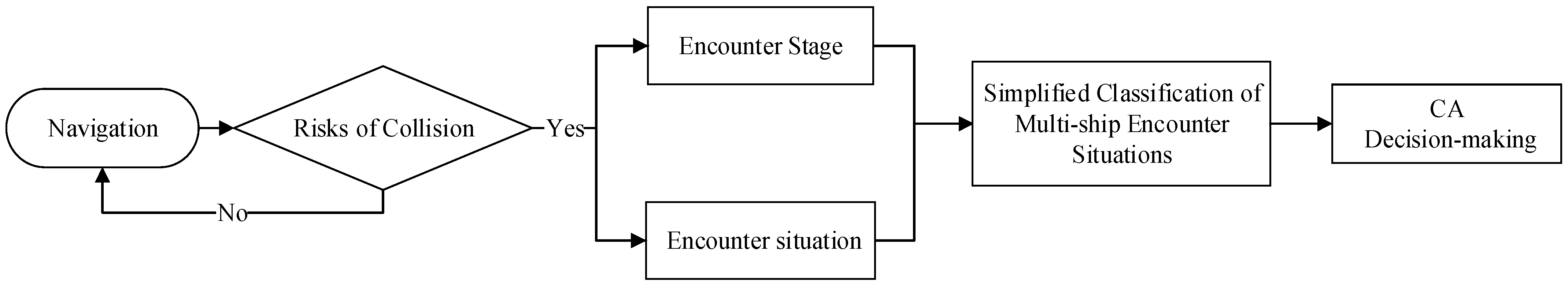
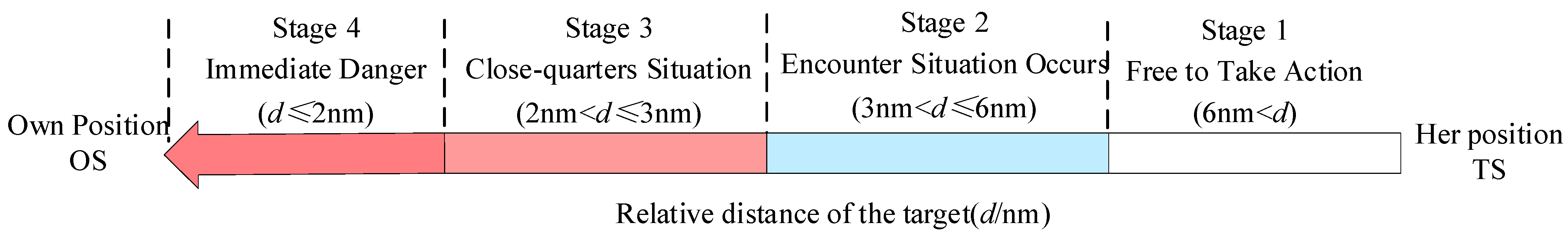
2. Collision Risk Identification and Multi-Ship Encounter Classification

As mentioned in Section 1.2 of this document, all navigational and collision hazards are taken into full consideration when complying with COLREGs. Therefore, when a keep-watching officer or the MASS is underway, the presence of hazards should be considered first, followed by a judgment on the encounter stage and the encounter situation. The presence of a collision risk is a necessary condition for the formation of crossing and head-on situations.

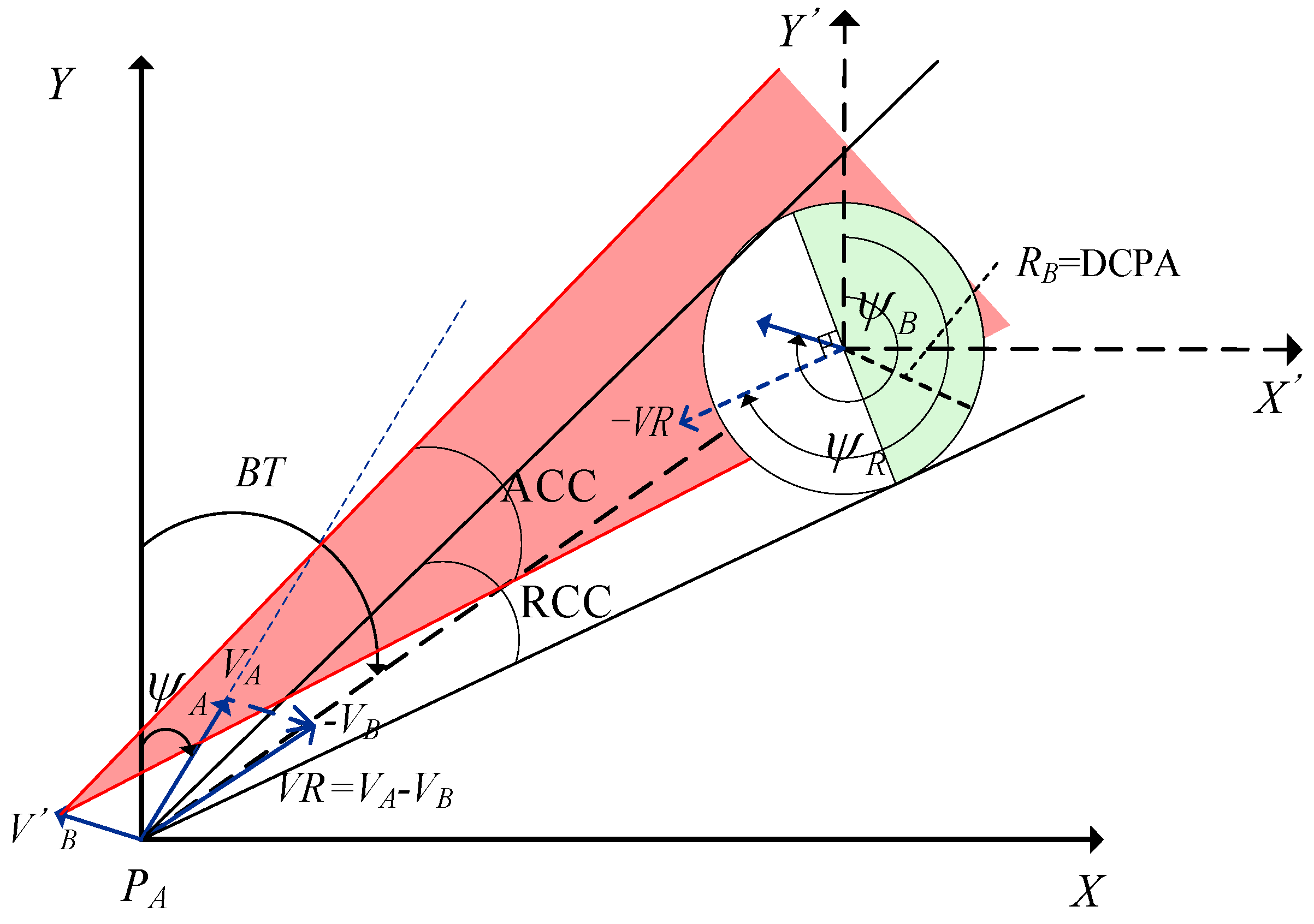
2.1. Collision Risk Identification Method

When there is a collision risk between two ships, and if the OS is the giving way ship, then it is necessary to take CA action in regard to the TS. Based on the CA experience in open water with good visibility, the DCPA threshold is set to 1 nm. When TCPA > 0 and the OS and TS are within 1 nm of each other (i.e., |DCPA|< 1 nm), there is collision risk between the OS and TS [37]. When TCPA < 0, it implies that the TS has passed the closest point of approach and there is no risk of collision with the OS.
The velocity obstacle (VO) method also analyzes ship collision risk and is more intuitive than TCPA and DCPA. As shown in Figure 2, the TS’s point of mass (PB) is expanded into a circle (hereinafter referred to as the expansion circle), and the expansion radius RB is set to be the same as the threshold value of the required DCPA. The essence of the VO algorithm is the process of avoiding the “expanding circle” of the TS’s point of mass, PB.
In addition, the speed of the OS is denoted as VA, and its course as ψ A A; the TS’s speed is VB, and its course as ψ B , with BT representing the true course. ψ R and VR (VR = VAVB), respectively, represent the relative course and relative speed of TS relative to the OS. Defining a directed line segment λ ( P A , V R ) , starting from the OS’s point of mass (PA), the direction is parallel to VR and the length is modulo VR. Two rays, Lam and Lan, are made from the PA of the OS tangent to the expansion circle of the TS, and the area enclosed by these two rays is termed the relative collision cone (RCC). If there is a directed line segment λ ( P A , V R ) between Lam and Lan, it implies that there is a collision risk between the OS and TS. Given that the RCC is based on relative velocity space, multiple benchmarks are created when a multi-ship encounter situation is involved. Hence, the absolute collision cone (ACC) is obtained by translating the RCC along the TS’s velocity vector, VB, through Minkowski sum operations, A C C = R C C V B . As shown in Figure 1, the red collision cone area, which shows the end of the VA of the OS’s velocity vector falling into the ACC, indicates that there is a collision risk between the OS and TS.
In this study, the VO algorithm is applied to the identification of ship collision risk. It is assumed that the maximum speed of the OS and all TSs is 24 kn, and the current speed is 15 kn. As shown in Figure 3, the green semicircle is defined as the Safe Velocity Cone (SVC), and the radius of the SVC is the distance that the ship has traveled for 5 min at its maximum speed. The thin line at the bow is the vector of the ship’s current speed for 5 min, and the dotted line at the stern indicates the trailing trail for 2 min, with one point recorded every 30 s. Different ship icons and trails are indicated by different colors, e.g., blue for the OS, red and purple for TS1 and TS2, respectively, which are all shown in the legend in the lower right corner.
According to the set length of the ship’s velocity vector, translate the TS’s RCC along the direction of the TS’s velocity vector, with the OS as the starting point, to the end of the TS’s velocity vector to obtain the corresponding TS’s ACC.
When the two ships encounter, as shown in Figure 3a, the red cone-shaped area indicates the ACC of TS1; if the end of the OS’s velocity vector line V is located within the ACC of TS1, there is a collision risk between the two ships. In the case of a multi-vessel encounter, as shown in Figure 3b, the ACCs of the OS against TS1 and TS2 (red and purple conical zones, respectively) are merged together, and it is found that the end of the OS’s velocity vector, V, falls within the ACCs of TS1 and TS2, indicating that there is a collision risk between the OS and both TS1 and TS2.
Judson et al. [38] proposed a knowledge data-base-based ship risk management system with existing ECDIS capable of route planning and decision support. To more clearly demonstrate and identify the possible risks faced by each ship in a multi-vessel encounter situation, inspired by an extant study [39], the velocity vectors, wake trails, and ACC and SVCs of the OS and all TSs in the encounter situation are visualized as shown in Figure 4. The collision risk between the OS and all TSs individually can be clearly observed in Figure 4. There is a collision risk between the OS and both TS1 and TS2, and no collision risk between TS1 and TS2. Using this method, it is possible to synthesize the collision risk between ships, determine the possible CA decision of TSs, and track the potential collision risk with TSs as the situation develops.

2.2. Principles for the Delimitation of Multi-Ship Encounters

In a multi-ship encounter, the responsibilities of ships vary based on their type or condition, as stipulated by Rule 18 of the COLREGs [20]. The hierarchy of avoidance responsibilities is as follows: power-driven vessels > sailing vessels underway > vessels engaged in fishing > vessels restricted in their ability to maneuver > vessels not under command. Additionally, the requirements for lights and shape configurations vary depending on the ship’s length. For simplicity, each vessel discussed in the multi-vessel encounter situation in this text is assumed to be a power-driven vessel exceeding 50 m in length. Cockcroft and Lameijer [40] detail collision avoidance rules (COLREGs), how to interpret the regulations, and how to avoid collisions.
Rules 13–15 of the COLREGs delineate three types of encounter situations for power-driven vessels within visible range of each other: overtaking, head-on situations, and crossing situations. These rules emphasize the significant relationship between the risk of collision and the formation of encounter situations relative to the distance between ships. It is crucial to verify the risk of collision by observing the ship’s light and shapes, which depend on the visible distance of the light and shapes. COLREGs mandate that vessels longer than 50 m must be equipped with a white masthead light visible from at least 6 nm and port and starboard lights and stern lights visible from at least 3 nm.
In practical terms, the distance between ships required to determine a crossing situation—and thereby initiate appropriate actions—should typically be within the legal minimum visible distances between the stern light and the sidelight of the navigating ship, i.e., between 3 and 6 nm [37]. There is no distinction between a stand-on ship and a give-way ship in head-on situations, but visibility of the masthead light and both sidelights is crucial, aligning with the distances applicable to crossing situations. In the case of overtaking, if the overtaking vessel can see the other vessel’s stern light and there is ambiguity over whether it is overtaking, it should be assumed to be so. Therefore, the appropriate distance for assuming overtaking should be more than 3 nm. OS must continually keep watching the movements of all TSs, assess the time to the closest point of approach (TCPA), and determine if there is a collision risk with any TS beyond 6 nm, taking the necessary actions to prevent a collision as they enter the encounter situation partition. The research in this paper provides some limitations on the relative approaching speeds of ships. When the TSs and the OS form a head-on or crossing situation, the relative speeds are similar in magnitude. To summarize, when two ships are more than 6 nm apart, they are in the free action stage. Between 3 and 6 nm, they are in the encounter situation stage, where there is a risk of collision that necessitates actionable decisions as per visibility rules, as shown in Figure 5. As the ships continue to approach and the distance narrows to 2–3 nm, a close-quarters situation develops, where actions by one ship alone may not ensure a safe passage [41]. At distances less than 2 nm, an imminent danger arises where the actions of one ship alone can no longer prevent a collision.
The definition of an encounter situation in the COLREGs is ambiguous to a certain extent. It states that a situation arises when “two power-driven vessels are meeting on reciprocal or nearly reciprocal courses so as to involve risk of collision”. Many studies define the boundary for such encounters as 5° to the port and starboard of a vessel’s bow, or as half a meridian point. Given the COLREGs guidance that “When a vessel is in any doubt as to whether such a situation exists, she shall assume that it does exist”, it is prudent to consider a wider angle. In this study, we adopt the fuzzy boundary method discussed in previous studies [42,43] and set the boundary at 10° to both the port and starboard sides of the ship’s bow. Wang et al. [44] analyzed the segmentation of encounter situations, categorizing starboard encounters between [5°, 67.5°] and (67.5°~112.5°]. Further, Wang et al. [45] defined port side encounter situations as ranging from [247.5°, 292.5°] and (292.5°~354°]. In our study, we consider changes in the TS’s heading within these defined angles, which can alter the encounter situation. Specifically, a situation occurs when the TS is located between 292.5° and 67.5° relative to the OS’s beam angle, the TS’s heading aligns similarly to that of the OS, and the speed of TS is greater than OS, indicating an overtaking. Conversely, when the TS’s heading is nearly perpendicular to the OS’s heading, this indicates a crossing situation.
Additionally, in light of the COLREGs, which differentiate between a stand-on ship and a give-way ship in a crossing situation—and dictate that the give-way ship should avoid passing from bow of the TS—it is necessary to tailor CA decisions to the specific angles of the crossing situation. Consequently, encounter situations between the OS and TS in visual encounters are categorized into the following seven types:
(1)
HO, head-on
(2)
SPC, small angle port crossing
(3)
BPC, big angle port crossing
(4)
SSC, small angle starboard crossing
(5)
BSC, big angle starboard crossing
(6)
OG, overtaking
(7)
ON, overtaken
As illustrated in Figure 6, the heading of the OS is assumed to be 000°. The degrees marked on the large circle represent TS’s relative bearing to the OS, while the degrees on the small circle indicate the heading of TS. The placement of the small circles at the position of the critical point suggests that once TS crosses this boundary, a new encounter situation emerges. For instance, if TS is located within [350°~10°], a head-on situation exists; however, outside this range (10°, 350°), a head-on encounter is not possible. Similarly, if TS is within [292.5°~67.5°], an overtaking situation occurs with the OS overtaking the TS, but outside these limits (67.5°, 292.5°), the OS overtaking the TS is not possible. The diagram uses different color zones to indicate varying encounter scenarios and associated responsibilities between the OS and TS based on TS’s relative bearing and heading [46]. The meanings of specific abbreviations used in the subdivisions are detailed in Table 1. For example, in the red zone marked CS_GW within the small circle, TS’s course falls within a zone that creates a crossing situation where OS is the give-way ship.
For instance, in the upper right corner of Figure 6, positioned at a relative bearing of 010° from the OS, when TS’s heading shifts clockwise from 180° to 077.5°, it indicates a situation where the OS is crossing and overtaking TS (overtaking requires VOS > VTS). In this case, the OS must take collision avoidance (CA) actions. Conversely, when TS’s heading is between 077.5° and 180°, there is no risk of collision with the OS, no differentiation of encounter situations is necessary, and the OS sails as a stand-on ship, as detailed in Table 2.

3. Simplified Classification of Multi-Ship Encounter Situations

The classification of multi-ship encounter situations in this study is based on the COLREGs, nautical practice, and the urgency of risk. The literature [44] quantified the encounter situation, distance between two ships in an overtaking situation is less than 3 nm, and in a crossing and head-on situation, it is less than 6 nm. We focus on the general encounter stage, where the distance between the TSs and the OS ranges from 3 to 6 nm. Figure 7 provides a schematic diagram of this classification, with the OS at the center and TSs distributed in different relative bearing zones, all within a 3–6 nm radius from the OS. When TSs are at a distance of 6 nm, forming crossing and head-on situations, the OS must take action to avoid a collision. Conversely, if TSs are overtaking the OS at a distance of 3 nm, the OS keeps course and speed. However, when the OS is 3 nm away from a TS ahead and is overtaken, it must take collision avoidance actions. It is important to note that TSs beyond 6 nm are not disregarded; rather, they fall outside the immediate scope of this analysis. OS must continually keep watching the movements of all TSs, assess the TCPA, and determine if there is a collision risk with any TS beyond 6 nm, taking necessary actions to prevent a collision as a give-way vessel.
Wang et al. [45] indicated that the avoidance responsibilities of the target ships and all conflict-encountering ships in its perception region should be considered when analyzing the complex encounter situation. Inspired by this model, we built on the classification of multi-ship encounters. This classification is streamlined based on the relative positional relationships and navigational characteristics between the TSs and the OS. Encounters are categorized either by the similarities and differences in their situations or by the collision risk between TSs.

3.1. Classification of Similarities and Differences in Encounter Situations Created by Multi-Ships and the OS

If the OS forms the same encounter situation with several TSs, it is defined as the same multiple encounter situation (SM), and if the OS forms different encounters with several TSs, then it is defined as a different multiple encounter situation (DM) [36].

3.1.1. TSs and the OS Meet in the Same Multiple Encounter Situation (SM)

SM can borrow the idea of clustering to simplify the multi-ship encounter situation, which has a total of 10 types of situations, as shown in Table 3.
In the SM, except for the SM-OGN and SM-BSSC, the OS maintains the same collision avoidance (CA) responsibilities and decisions toward the target ships (TSs). The OS’s actions are based on an analysis of distance and danger clustering among the TSs. In the SM-BSSC situation, while the OS’s responsibilities to the TSs remain the same, the CA decisions differ and are influenced by the danger clustering analysis between the TSs, which further influences the CA decisions of the OS. Conversely, in the SM-OGN situation, the responsibilities of the OS toward the TSs vary. Hence, the OS specifically focuses on avoiding collisions with the overtaken ship.

3.1.2. TSs and the OS Meet in a Different Multiple Encounter Situation (DM)

DM can be simplified by borrowing the idea of clustering to simplify the multi-ship encounter situations, which are 9 types of situations, as shown in Table 4.
In navigational practice, DM and SM can occur simultaneously. Even if TS1 and TS2 were in the same relative bearing, differences in their headings can lead to more complex and composite situations. For example, Figure 8 demonstrates various potential encounter situations of TSs relative to the OS, including SM-port crossing (SM-PC), SM-overtaking (SM-OG), head-on and port crossing (DM-HOPC), head-on and overtaking (DM-HOOG), port crossing and overtaking (DM-PCOG), port and starboard crossing (DM-PSC), starboard crossing and overtaking (DM-SCOG), SM-overtaking and overtaken (SM-OGN), port crossing and overtaken (DM-PCON), and port crossing and overtaken (DM-PCON).

3.2. Classification According to Risk or No Risk of Collision between Multiple Vessels

For the aforementioned SM and DM multi-ship encounter situations, considering the interactions between target ships (TSs), each TS is clustered into a “target ship group” and categorized based on the presence or absence of collision risk among the TSs. This classification primarily addresses navigational practice needs, analyzing situations where the OS is the give-way ship. It also aids in providing a reference for CA decision-making.

3.2.1. No Risk or Potential Risk of Collision between TSs

In such situations, whether under DM or SM, the OS may alter its course to starboard to pass the sterns of all TSs if the spacing between the TSs is insufficient for safe passage, as illustrated in Figure 9a. This action aligns with the responsibilities and behaviors prescribed by the COLREGs.
Conversely, if there is a considerable distance between the TSs, as shown in Figure 9b, and unlike the encounter situation involving different TSs, there is no risk or potential risk among the TSs, the OS may navigate safely between the TSs.

3.2.2. Risk or Potential Risk of Collision between TSs

TS1 and TS2, each posing a risk or potential risk of collision, may be in the same or different encounter situations with the OS, respectively. In making the CA decisions between TS1 and TS2, the OS adopts the idea of cluster analysis, which influences each TS to take appropriate avoidance actions. TS1 and TS2 are considered a group of target ships, suggesting that the OS should not navigate between the TSs. Moreover, the OS should avoid crossing the bow of the TSs while they are taking or about to take action, as depicted in Figure 10a,b. SM-BSSC and DM-HOSC are presented as examples to illustrate the same and different encounter situations, respectively.
In summary, when classifying and simplifying multi-ship encounter situations, the interactions and uncertainties among TSs are considered. The idea of cluster analysis is utilized to categorize complex multi-ship encounter situations into superpositions of simpler spatial encounters. In the SM, it is generally necessary to cluster TSs and coordinate their CA actions. However, it remains crucial to assess whether there is a risk of collision between the TSs. In the DM, it is essential first to determine the risk between the TSs before implementing CA strategies. These strategies may involve deciding whether it is feasible to navigate between the TSs. This process is depicted in Figure 11.

4. Collision Avoidance Decision-Making in Multi-Ship Encounter Situations

The responsibility of the OS and the CA actions to be taken vary across different encounter situations. According to the COLREGs, these maneuvers may include altering course, altering speed, maintaining course and speed, and combining course and speed adjustments. Rule 8 of the COLREGs stipulates that CA decision-making should be taken in ample time, and a succession of small alterations of course and speed should be avoided. It also notes that steering alone may be an effective action to avoid a close-quarters situation, if necessary, the vessel shall slacken her speed or take all of the speed off by stopping or reversing her means of propulsion. It is mentioned in Rule 14 that when two power-driven vessels are meeting in a head-on situation so as to involve the risk of collision, the vessels shall alter course to starboard and pass on the port side of the other. Rule 15 states that the TSs on the starboard side of the OS shall keep out of the way and shall avoid crossing ahead of the TSs.
In coordination with the delineation of encounter situations in this study, a careful decomposition of their CA behaviors, considering the COLREGs, responsibility, and feasible decision-making, is shown in Table 5.
When TS1 is positioned at a relative bearing of 350°~010° from the OS, it creates either a head-on or overtaking situation. Meanwhile, TS2, located at 350°~067.5°, presents a situation of head-on, small-angle starboard crossing, and overtaking with the OS. In this context, the OS can consider the interactions between TSs based on the clustering idea and may alter course to starboard.
TS1, found between 010°and067.5° relative to the OS, establishes a small-angle starboard crossing situation. TS2, also between 010°~067.5° and further between 112.5°~292.5°, presents small-angle starboard crossing, overtaking, and big-angle port crossing situations with the OS. Considering the distance between the TSs and risk posed by TSs using the clustering idea, The OS can alter course to starboard.
TS1, located between 067.5°and ~112.5° relative to the OS, leads to a large-angle starboard crossing situation. Concurrently, TS2, spanning 010°~292.5° relative to the OS, encompasses starboard crossing, overtaking, being overtaken, and a big-angle port crossing situation. Given the potential risks from TSs, informed by the idea of clustering, the OS has the option to alter course to either port or starboard, or even alter course to starboard and slacken speed to prevent a collision.
When TS1 and TS2 are located at 112.5°~292.5° from the OS’s relative bearing, they may create situations of being overtaken or a big-angle port crossing with the OS. In this situation, the OS as a stand-on ship, should keep course and speed.
If TS1 is positioned at 292.5°~350° relative to the OS and forms an overtaken situation, and TS2 is between 350°and ~112.5° from the OS, resulting in a head-on or crossing situation, the OS may alter course to starboard or alter course to starboard and slacken speed to prevent a collision. If TS2 is found at 112.5°~247.5°, where the OS is involved in both overtaking and being overtaken (SM-OGN), then it will alter course to port. If TS2 is between 247.5° and ~350° relative to the OS and it constitutes an overtaken situation, then the OS will also alter course to port; however, if it involves a port crossing, the OS will alter course to starboard.
When TS1 and the OS encounter a small-angle port crossing situation, and TS2 is positioned at 350°~112.5° from the OS, forming a crossing and head-on situation, the OS can alter course to starboard or alter course to starboard and slacken speed. When TS2 is between 112.5° and ~350° relative to the OS, resulting in either an overtaken or a port crossing situation, and the OS as a stand-on ship, will keep course and speed.
It should be noted that some ships obtain information via onboard navigational aids, so decisions to slow down or speed up may not be readily apparent on systems like AIS or APRA. Therefore, in expansive sea areas, most ships opt for course alteration to avoid collisions.

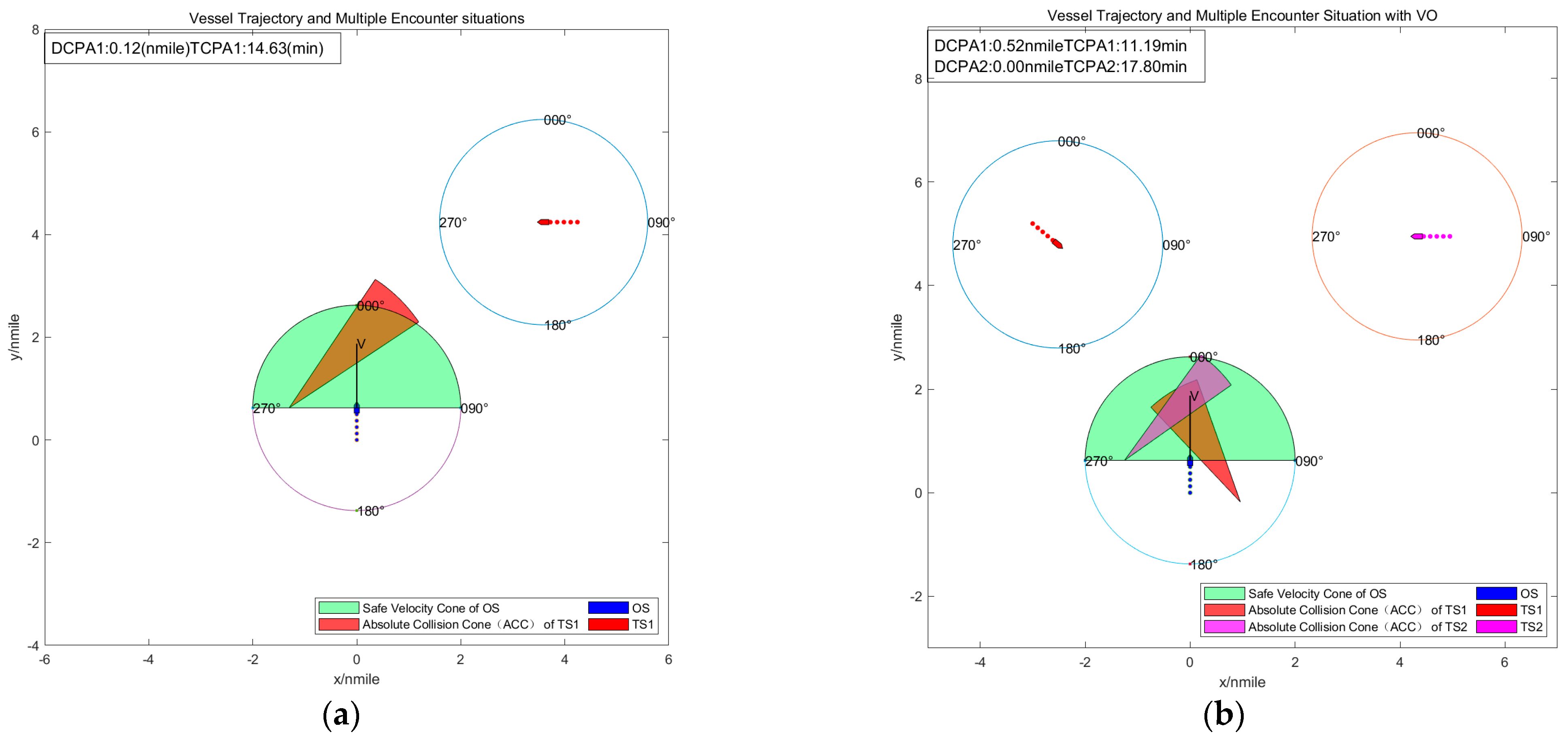
5. Simulation Experiment

In this study, multi-ship encounter scenarios #5~22 from the Imazu problem [47] are selected for experimental purposes (scenarios #1~4, which involve only two ships, are not simulated). Among these, scenarios #5~11 involve three-ship encounters, and scenarios #12~22 involve four-ship encounters, as depicted in Figure 12. In these experiments, the reference ship is positioned at coordinates (0,0), oriented at a heading of 000°, and traveling at a speed of 15 knots. The VO method is employed to calculate the safety zones for the velocity vectors of the OS and the TSs and to assess the risk of collision within each scenario.

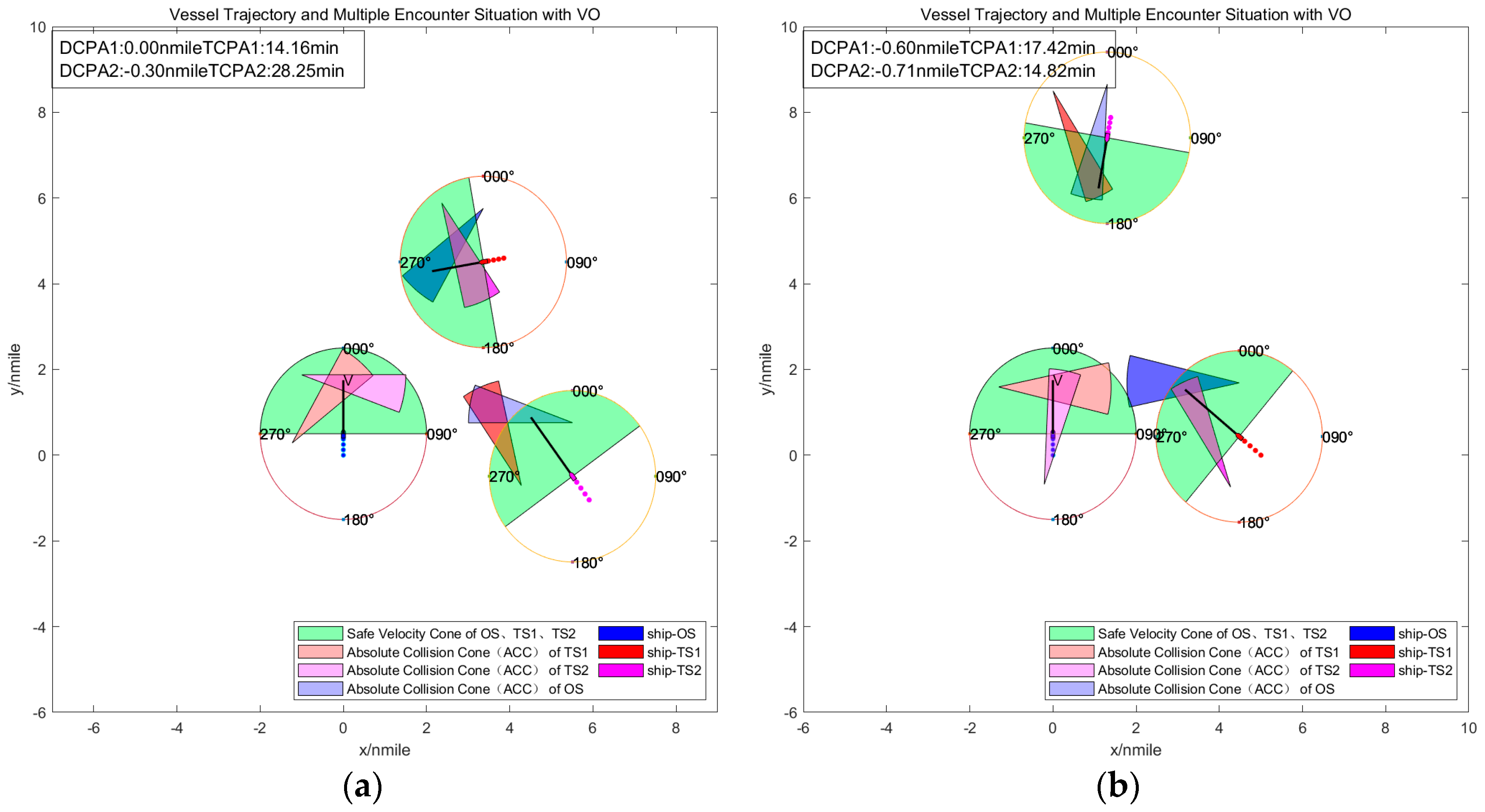
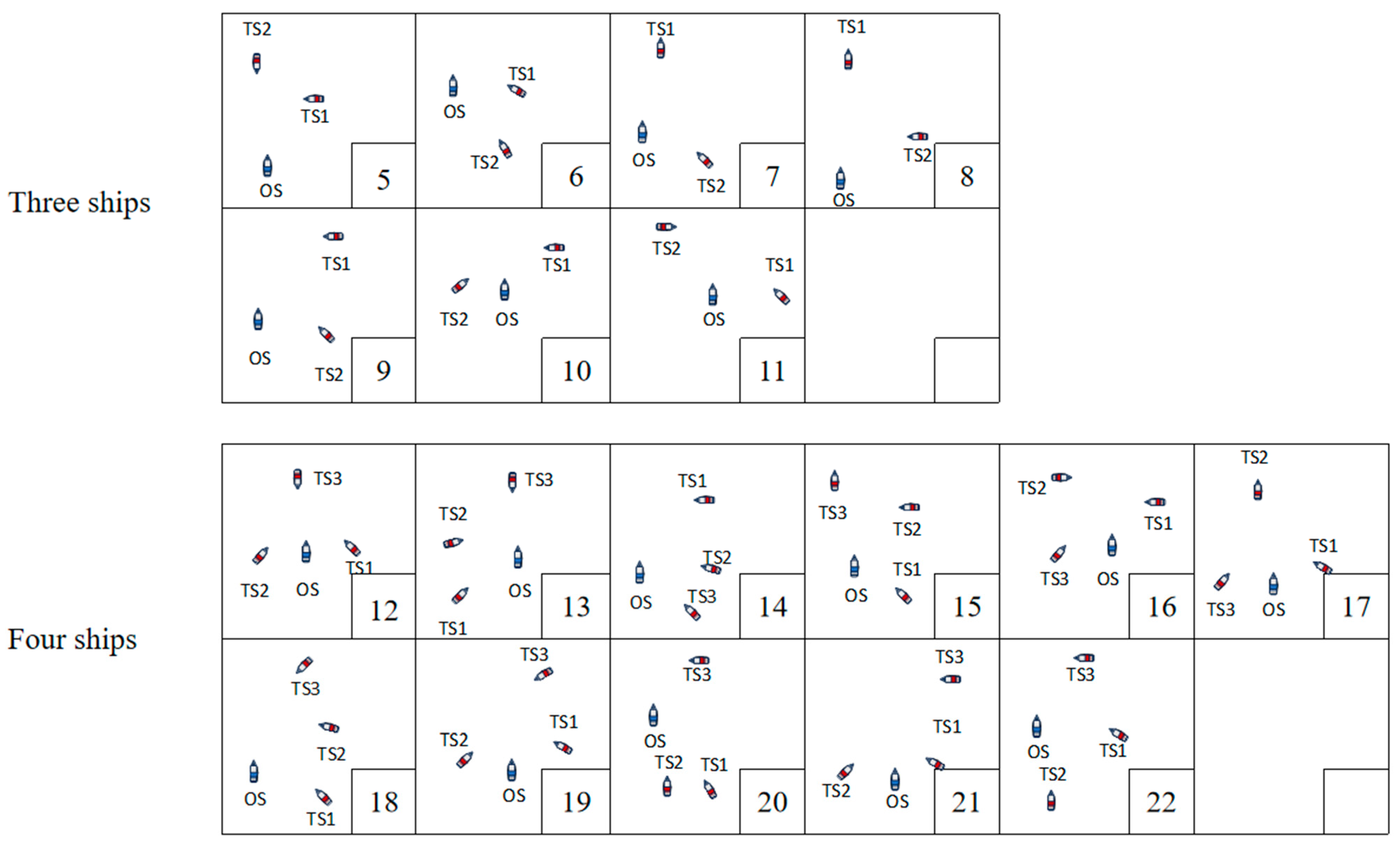
5.1. Encounter Situation Involving Three Ships

By setting the position, speed, and heading of the TSs, as shown in Table 6, the risk of collision between TSs and the OS exists and constitutes the #5~11 three-ship encounter situation in the Imazu problem. Furthermore, another set of the DM-OGN situation, which is not in the problem, is added, as shown in Figure 13 and Figure 14, respectively.
In the encounter situations #5 and #8, as depicted in Figure 13a,b, TS1 and TS2 are located within OS’s relative bearing of 350°~067.5°. Although there is no collision risk between TS1 and TS2, the spacing between them is too narrow to safely navigate between the ships. Consequently, TS1 and TS2 are clustered as a group of target ships, prompting OS to alter its course to starboard.
In encounter situation #6, under the same multiples encounter situation of big and small angle crossing (SM-BSC), as shown in Figure 14a, TS1 and TS2 are within the relative bearing of 067.5° to 112.5° from the OS. Although there is no risk of collision between TS1 and TS2, the spacing between them is too narrow for the OS to pass safely. Consequently, TS1 and TS2 cluster together as a group of target ships. Furthermore, the OS needs to alter its course to starboard and slacken speed or alter course to port with a whole circle.
The encounter situations #10 and #11 are depicted in Figure 14b,c. In these, TS1 and TS2 meet the different multiple encounter situations of port and starboard crossing (DM-PSC) with the OS, respectively. In situations #10, the relative bearings of TS1 and TS2 to the OS are 247.5°~292.5° and 010°~067.5°. There is no collision risk between TS1 and TS2, and TS1 is designated as a give-way ship. Given that TS1 will alter course to starboard, passing through the stern of the OS and TS2, the OS will also alter course to starboard. In Figure 14c for situations #11, TS1, as the give-way ship alters course to starboard to pass the stern of the OS and TS2. The OS needs to account for the space required for TS1’s CA decision and may consider altering its course to starboard and slackening speed accordingly.
Situations #7 and #9 are illustrated in Figure 14d,e, where TS2’s relative bearing to the OS is between 067.5° and ~112.5°. In these encounters, the OS is the give-way ship; situation #7 presents a potential but not immediate risk of collision between TS1 and TS2, while situation #9 has no collision risk between them. Consequently, in situations #7 and #9, the OS can follow the CA decisions outlined in Table 5, either altering course to starboard or combining a course alteration to starboard with slackening speed.
In the different multiples encounter situation of overtaking and overtaken (DM-OGN) shown in Figure 14f, there is a potential but not immediate risk of collision between TS1 and TS2. Considering the cost-effectiveness of the ship’s CA decisions, as summarized in Table 5, the OS can alter its course to port.

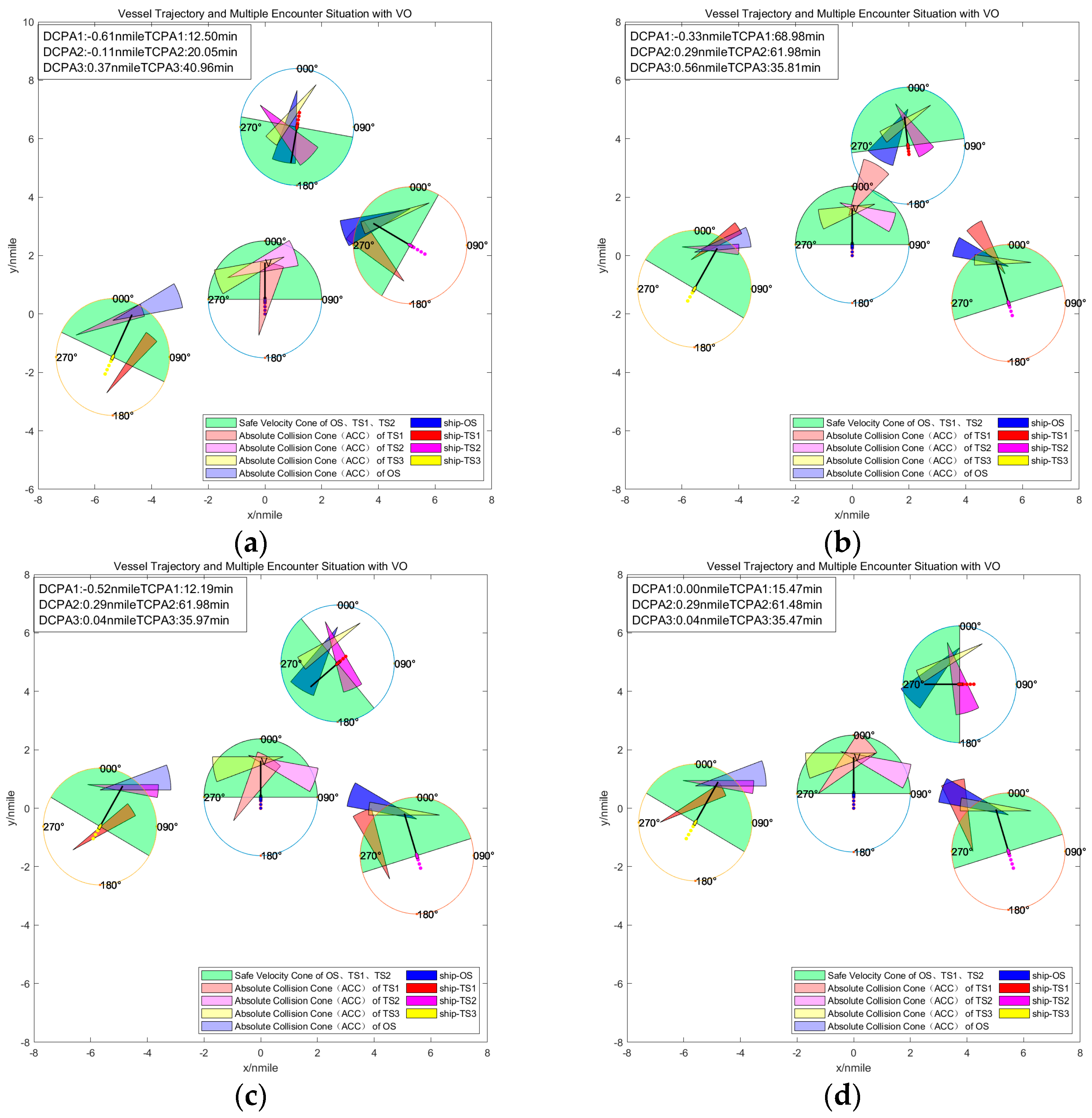
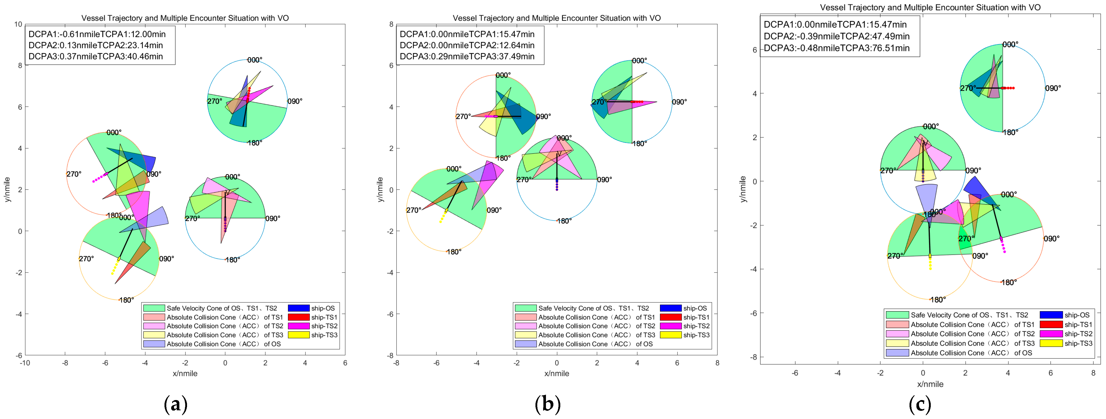
5.2. Encounter Situation Involving Four Ships

By configuring the position, speed, and course of the TSs (detailed in Table 7), these ships are identified as being at risk of collision with the OS, culminating in a four-ship encounter situation from #12 to #22 in the Imazu problem. This is depicted in Figure 15, Figure 16, Figure 17 and Figure 18. In these situations, both the OS and the TSs need to make CA decisions. The use of the clustering idea supports these decisions by simplifying the complex multi-ship encounter situation as outlined in Table 7.
Situations #12, #17, #19, and #21, as illustrated in Figure 15a–d, TS2 and TS3 are positioned on the port and starboard sides of the OS, respectively, creating a big-angle crossing situation with the OS. In these encounters, TS3 acts as the give-way ship. Across these four situations, TS1 and the OS engage in head-on, overtaking, and small-angle crossing situations, respectively. In Figure 15a,c,d, there is no collision risk between TS1 and TS2, but there is a collision risk between TS2 and TS3. In Situation #17, shown in Figure 15b, TS2 is at risk of collision with all TSs involved, both as a stand-on ship for TS3 and a give-way ship for TS1. Consequently, the OS disregards the give-way ship (TS3), simplifies the four-ship encounter to a three-ship situation, as documented in Table 7, and follows the CA decisions outlined in Table 5. These decisions include altering course to starboard or both altering course to starboard and slackening speed in Situations #12, #17, #19, and #21.
In Situations #13, #16, and #20, as depicted in Figure 16a–c, TSs are positioned at relative bearings of 112.5°~350° to the OS. In Situation #13, there is no collision risk among the TSs, with TS2 and TS3 located on the port side of the OS. Situation #16 mirrors #13, with the key difference being a collision risk between TS1 and TS2, requiring OS to keep watching the TSs’ behavior closely. In Situation #20, TS2 and TS3 are overtaking the OS and are designated as the give-way ships. OS groups TS2 and TS3 as a “target ship group”, simplifying the encounter according to the methods detailed in Table 7. Based on the guidelines in Table 5, the OS avoids a collision by altering course to starboard.
In Situations #14, #15, and #18, as illustrated in Figure 17a–c, the TSs are located at relative bearings of 350°~112.5° from the OS. In Situation #14, there is a starboard crossing between the TSs and the OS, with the OS as the give-way ship. Figure 17a indicates a collision risk between TS1 and TS2, and between TS2 and TS3, prompting OS to alter course to starboard and slacken speed, considering two-by-two clustering of the ships. In Situations #15 and #18, the OS also acts as the give-way ship, with no collision risk between the TSs. However, due to the close distance between the TSs, the OS cannot safely navigate between them and should therefore alter course to starboard and slacken speed.
In Situation #22, as depicted in Figure 18, there is no collision risk between TS2 and TS1, both of whom are overtaking the OS. However, there is a collision risk between TS2 and TS3, with TS3 designated as the give-way ship. The simplified encounter dynamics are outlined in Table 7. Consequently, the OS has the option to alter course to either port or starboard and slacken speed.

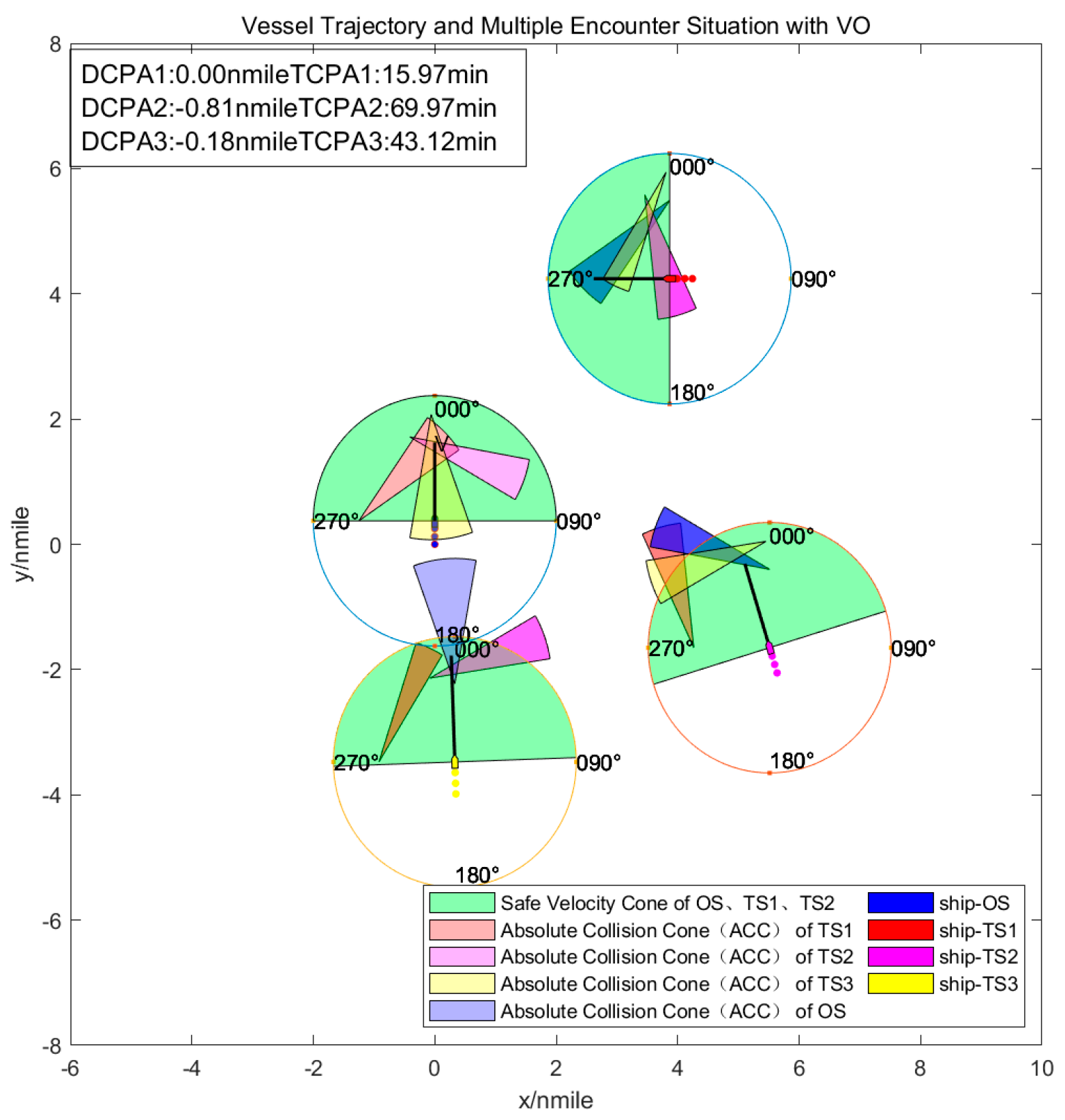
5.3. Encounter Situation with AIS Data

The AIS data selected was purchased from Ship News (https://www.shipxy.com/, accessed on 15 March 2019), and the original data geographic location ranges from 120.17° E to 120.67° E in longitude and 35.92° N to 36.17° N in latitude, which covers the entire Qingdao port area around the data in March 2019.
As depicted in Figure 18, multi-vessel encounter scenarios were obtained by extracting the data in the table from AIS data. Figure 19b is plotted with (160° E, 36° N) as the coordinate origin (0, 0).
In the situation illustrated in Figure 19a, there is a starboard crossing between the TSs and the OS, with the OS as the give-way ship. Figure 19a indicates a collision risk between TS1 and TS2, indicating that TS2 was overtaking TS1, prompting the OS to alter course to starboard, considering two-by-two clustering of TSs. As depicted in Figure 19b, according to the AIS data, it can be seen that the OS changed course to the starboard, which is consistent with the statement in Table 5.
The validity of the multi-ship encounter classification proposed in this study is demonstrated through the simulation and analysis of the four-ship encounter problem defined by Imazu. The VO algorithm effectively visualizes the velocity vector safety zones for the OS and TSs, aiding in identifying collision risks between ships. This analysis aids in making the safe collision avoidance (CA) decisions. While the four-ship encounter can be simplified to a three-ship or even two-ship situation through cluster analysis, it remains crucial to assess the collision risk between TSs.

6. Conclusions and Future Studies

6.1. Conclusions

The definition and identification of collision risks in multi-ship encounter situations are critical components of the intelligent CA decision-making process for MASSs navigating in complex waters. This study introduces a method for visualizing collision risks using VO techniques and employs clustering strategies to streamline complex multi-ship situations. This approach helps pinpoint potential collision threats between the OS and TSs and among the TSs themselves, offering operators a clearer view of the TSs’ intentions and aiding in the prediction of their CA decision. Simplifying the classification of encounter situations benefits the coordination of CA decisions in complex situations and facilitates a more intuitive approach to managing collision risks involving multiple TSs. The classification method, developed in this study, aids ships in making practicable CA decisions that adhere to the COLREGs, enhancing both manned and marine autonomous surface ships’ (MASSs) understanding of complex situations and their ability to make timely CA decisions.

6.2. Research Limitations and Future Studies

The study mainly focuses on open waters, fails to take into account restricted waters and harbor areas. And this paper has not carefully considered the restricted visibility situation of Rule 9 in COLREGs. Future research aims to further classify and simplify complex multi-ship encounter situations and explore their integration into autonomous ship CA algorithms. The environmental factors are fully considered to determine the precise speed and course adjustment strategy, and the method of autonomous collision avoidance for ships adapted to restricted waters is constructed to meet the CA decision-making needs of ships in different navigable waters.

Author Contributions

Conceptualization, H.L. and X.M.; methodology, H.L.; software, X.M.; validation, H.L., Y.Y. and X.S.; formal analysis, X.M. and G.T.; investigation, L.Z., X.K. and J.S.; resources, H.L., X.M. and G.T.; data curation, X.M.; writing—original draft preparation, H.L. and X.M.; writing—review and editing, H.L. and Y.Y.; visualization, H.L. and X.M.; supervision, X.S., L.Z., X.K. and J.S.; project administration, H.L., Y.Y. and X.S.; funding acquisition, H.L., Y.Y. and X.S. All authors have read and agreed to the published version of the manuscript.

Funding

This research was funded by (a) the National Natural Science Foundation of China (No. 52071049); (b) Liaoning Provincial Science and Technology Plan (Key) project (No. 2022JH1/10800096); (c) the Natural Science Foundation of Liaoning Province (No. 2022-MS-159); (d) National Key R&D Program of China (2022YFB4300803, 2022YFB4301402); and (e) the Fundamental Research Funds for the Central Universities (3132023627).

Institutional Review Board Statement

Not applicable.

Informed Consent Statement

Not applicable.

Data Availability Statement

The original contributions presented in the study are included in the article, further inquiries can be directed to the corresponding author.

Conflicts of Interest

The authors declare no conflicts of interest.

References

  1. EMSA. Annual Overview of Marine Casualties and Incidents; EMSA: Lisbon, Portugal, 2023. [Google Scholar]
  2. Song, J.; Shoji, R.; Tamaru, H.; Kayano, J. Modeling Human Encounter Situation Awareness Results Using Support Vector Machine Models. Appl. Sci. 2023, 13, 7521. [Google Scholar] [CrossRef]
  3. Yim, J.; Kim, D.; Park, D. Modeling perceived collision risk in vessel encounter situations. Ocean Eng. 2018, 166, 64–75. [Google Scholar] [CrossRef]
  4. Sánchez-Beaskoetxea, J.; Basterretxea-Iribar, I.; Sotés, I.; Machado, M.d.L.M.M. Human error in marine accidents: Is the crew normally to blame? Marit. Transp. Res. 2021, 2, 100016. [Google Scholar] [CrossRef]
  5. Zhen, R.; Shi, Z.; Gu, Q.; Yang, S. A novel deterministic search-based algorithm for multi-ship collaborative collision avoidance decision-making. Ocean Eng. 2024, 292, 116524. [Google Scholar] [CrossRef]
  6. NTSB. Collision between Liquefied Gas Carrier Genesis River and Voyager Tow Houston Ship Channel, Upper Galveston Bay, Texas; NTSB: Washington, DC, USA, 2019. [Google Scholar]
  7. Gang, L.; Wang, Y.; Sun, Y.; Zhou, L.; Zhang, M. Estimation of vessel collision risk index based on support vector machine. Adv. Mech. Eng. 2016, 8, 2071836213. [Google Scholar] [CrossRef]
  8. Xu, Q.; Wang, N. A Survey on Ship Collision Risk Evaluation. Promet-Traffic Transp. 2014, 26, 475–486. [Google Scholar] [CrossRef]
  9. Xie, S.; Garofano, V.; Chu, X.; Negenborn, R.R. Model predictive ship collision avoidance based on Q-learning beetle swarm antenna search and neural networks. Ocean Eng. 2019, 193, 106609. [Google Scholar] [CrossRef]
  10. Namgung, H.; Jeong, J.S.; Kim, J. Real-Time Collision Risk Assessment System Based on the Fuzzy Theory in Accordance with Collision Avoidance Rules. In Proceedings of the 2020 Joint 11th International Conference on Soft Computing and Intelligent Systems and 21st International Symposium on Advanced Intelligent Systems (SCIS-ISIS), Hachijo Island, Japan, 5–8 December 2020; pp. 1–4. [Google Scholar]
  11. Sarhadi, P.; Naeem, W.; Athanasopoulos, N. An Integrated Risk Assessment and Collision Avoidance Methodology for an Autonomous Catamaran with Fuzzy Weighting Functions. In Proceedings of the 2022 UKACC 13th International Conference on Control (CONTROL), Plymouth, UK, 20–22 April 2022; pp. 228–234. [Google Scholar]
  12. Hu, Y.; Zhang, A.; Tian, W.; Zhang, J.; Hou, Z. Multi-Ship Collision Avoidance Decision-Making Based on Collision Risk Index. J. Mar. Sci. Eng. 2020, 8, 640. [Google Scholar] [CrossRef]
  13. Huang, Y.; van Gelder, P.H.A.J. Collision risk measure for triggering evasive actions of maritime autonomous surface ships. Saf. Sci. 2020, 127, 104708. [Google Scholar] [CrossRef]
  14. Yang, X.; Lou, M.; Hu, J.; Ye, H.; Zhu, Z.; Shen, H.; Xiang, Z.; Zhang, B. A human-like collision avoidance method for USVs based on deep reinforcement learning and velocity obstacle. Expert Syst. Appl. 2024, 254, 124388. [Google Scholar] [CrossRef]
  15. Li, Y.-P.; Liu, Z.-J.; Zheng, Z.-Y. Multi-ship encounter situational awareness based on AIS data. In Proceedings of the 2017 4th International Conference on Information, Cybernetics and Computational Social Systems (ICCSS), Dalian, China, 24–26 July 2017; pp. 523–527. [Google Scholar]
  16. Du, L.; Goerlandt, F.; Valdez Banda, O.A.; Huang, Y.; Wen, Y.; Kujala, P. Improving stand-on ship’s situational awareness by estimating the intention of the give-way ship. Ocean Eng. 2020, 201, 107110. [Google Scholar] [CrossRef]
  17. Murray, B.; Perera, L.P. Ship behavior prediction via trajectory extraction-based clustering for maritime situation awareness. J. Ocean Eng. Sci. 2022, 7, 1–13. [Google Scholar] [CrossRef]
  18. Zhen, R.; Shi, Z.; Liu, J.; Shao, Z. A novel arena-based regional collision risk assessment method of multi-ship encounter situation in complex waters. Ocean Eng. 2022, 246, 110531. [Google Scholar] [CrossRef]
  19. Tian, W.; Zhu, M.; Han, P.; Li, G.; Zhang, H. Pairwise ship encounter identification and classification for knowledge extraction. Ocean Eng. 2024, 294, 116752. [Google Scholar] [CrossRef]
  20. Cho, Y.; Han, J.; Kim, J. Efficient COLREG-Compliant Collision Avoidance in Multi-Ship Encounter Situations. IEEE Trans. Intell. Transp. Syst. 2022, 23, 1899–1911. [Google Scholar] [CrossRef]
  21. Gao, M.; Shi, G.; Liu, J. Ship encounter azimuth map division based on automatic identification system data and support vector classification. Ocean Eng. 2020, 213, 107636. [Google Scholar] [CrossRef]
  22. Song, J.; Kayano, J.; Shoji, R. Modeling human’s collision avoidance direction in an encounter situation using an ensemble classifier. Ocean Eng. 2023, 271, 113738. [Google Scholar] [CrossRef]
  23. Chen, X.; Liu, Y.; Achuthan, K.; Zhang, X.; Chen, J. A semi-supervised deep learning model for ship encounter situation classification. Ocean Eng. 2021, 239, 109824. [Google Scholar] [CrossRef]
  24. Lyu, H.; Hao, Z.; Li, J.; Li, G.; Sun, X.; Zhang, G.; Yin, Y.; Zhao, Y.; Zhang, L. Ship Autonomous Collision-Avoidance Strategies—A Comprehensive Review. J. Mar. Sci. Eng. 2023, 11, 830. [Google Scholar] [CrossRef]
  25. Lyu, H.; Yin, Y. COLREGS-Constrained Real-time Path Planning for Autonomous Ships Using Modified Artificial Potential Fields. J. Navig. 2019, 72, 588–608. [Google Scholar] [CrossRef]
  26. Huang, Y.; Chen, L.; van Gelder, P.H.A.J. Generalized velocity obstacle algorithm for preventing ship collisions at sea. Ocean Eng. 2019, 173, 142–156. [Google Scholar] [CrossRef]
  27. Chen, P.; Huang, Y.; Papadimitriou, E.; Mou, J.; van Gelder, P.H.A.J.M. An improved time discretized non-linear velocity obstacle method for multi-ship encounter detection. Ocean Eng. 2020, 196, 106718. [Google Scholar] [CrossRef]
  28. Zhao, L.; Roh, M. COLREGs-compliant multiship collision avoidance based on deep reinforcement learning. Ocean Eng. 2019, 191, 106436. [Google Scholar] [CrossRef]
  29. Ahmed, Y.A.; Hannan, M.A.; Oraby, M.Y.; Maimun, A. COLREGs Compliant Fuzzy-Based Collision Avoidance System for Multiple Ship Encounters. J. Mar. Sci. Eng. 2021, 9, 790. [Google Scholar] [CrossRef]
  30. Liu, H.; Deng, R.; Zhang, L. The application research for ship collision avoidance with hybrid optimization algorithm. In Proceedings of the 2016 IEEE International Conference on Information and Automation (ICIA), Ningbo, China, 1–3 August 2016; pp. 760–767. [Google Scholar]
  31. Li, S.; Liu, J.; Negenborn, R.R. Distributed coordination for collision avoidance of multiple ships considering ship maneuverability. Ocean Eng. 2019, 181, 212–226. [Google Scholar] [CrossRef]
  32. Wei, G.; Kuo, W. COLREGs-Compliant Multi-Ship Collision Avoidance Based on Multi-Agent Reinforcement Learning Technique. J. Mar. Sci. Eng. 2022, 10, 1431. [Google Scholar] [CrossRef]
  33. Zhu, J.; Gao, M.; Zhang, A.; Hu, Y.; Zeng, X. Multi-Ship Encounter Situation Identification and Analysis Based on AIS Data and Graph Complex Network Theory. J. Mar. Sci. Eng. 2022, 10, 1536. [Google Scholar] [CrossRef]
  34. Liu, K.; Wu, X.; Zhou, Y.; Yuan, Z.; Yang, X.; Xin, X.; Zhuang, S. A conflict cluster-based method for collision avoidance decision-making in multi-ship encounter situations. Ocean Eng. 2023, 288, 116038. [Google Scholar] [CrossRef]
  35. Zhen, R.; Shi, Z. A Novel Adaptive Visual Analytics Framework for Multiship Encounter Identification. J. Adv. Transp. 2021, 2021, 3063957. [Google Scholar] [CrossRef]
  36. Lyu, H.; Liu, W.; Guo, S.; Tan, G.; Fu, C.; Sun, X.; Zhao, Y.; Zhang, L.; Yin, Y. Autonomous collision avoidance method for MASSs based on precise potential field modelling and COLREGs constraints in complex sailing environments. Ocean Eng. 2024, 292, 116530. [Google Scholar] [CrossRef]
  37. Zhang, W.; Yan, C.; Lyu, H.; Wang, P.; Xue, Z.; Li, Z.; Xiao, B. COLREGS-based Path Planning for Ships at Sea Using Velocity Obstacles. IEEE Access 2021, 9, 32613–32626. [Google Scholar] [CrossRef]
  38. Judson, B. A Tanker Navigation Safety System. J. Navig. 1997, 50, 97–108. [Google Scholar] [CrossRef]
  39. Szlapczynski, R.; Szlapczynska, J. A Target Information Display for Visualising Collision Avoidance Manoeuvres in Various Visibility Conditions. J. Navig. 2015, 68, 1041–1055. [Google Scholar] [CrossRef]
  40. Cockcroft, A.; Lameijer, J. A Guide to the Collision Avoidance Rules; Elsevier Butterworth-Heinemann: Burlington, London, UK, 2011. [Google Scholar]
  41. Wang, X.; Liu, Z.; Cai, Y. The ship maneuverability based collision avoidance dynamic support system in close-quarters situation. Ocean Eng. 2017, 146, 486–497. [Google Scholar] [CrossRef]
  42. Perera, L.P.; Carvalho, J.P.; Guedes Soares, C. Solutions to the Failures and Limitations of Mamdani Fuzzy Inference in Ship Navigation. IEEE Trans. Veh. Technol. 2014, 63, 1539–1554. [Google Scholar] [CrossRef]
  43. Perera, L.P. Deep Learning Toward Autonomous Ship Navigation and Possible COLREGs Failures. J. Offshore Mech. Arct. 2020, 142. [Google Scholar] [CrossRef]
  44. Wang, X.; Wang, G.; Wang, Q.; Han, J.; Chen, L.; Wang, B.; Shi, H. A Construction Method of a Sequential Decision Chain for Unmanned-Ship Autonomous Collision Avoidance Based on Human-Like Thinking. J. Mar. Sci. Eng. 2023, 11, 2218. [Google Scholar] [CrossRef]
  45. Wang, G.; Wang, X.; Wang, Q.; Chen, L.; Han, J.; Wang, B.; Shi, H. Complex encounter situation modeling and prediction method for unmanned ships based on bounded rational game. Ocean Eng. 2023, 273. [Google Scholar] [CrossRef]
  46. Tam, C.; Bucknall, R. Collision risk assessment for ships. J. Mar. Sci. Tech. 2010, 15, 257–270. [Google Scholar] [CrossRef]
  47. Chun, D.; Roh, M.; Lee, H.; Yu, D. Method for collision avoidance based on deep reinforcement learning with path-speed control for an autonomous ship. Int. J. Nav. Arch. Ocean Eng. 2024, 16, 100579. [Google Scholar] [CrossRef]
Figure 1. Judgement collision avoidance flowchart.
Jmse 12 01289 g001
Figure 2. Velocity obstacle algorithm schematic.
Jmse 12 01289 g002
Figure 3. Absolute collision cone in a multi-ship encounter situation: (a) two ships; (b) three ships.
Jmse 12 01289 g003
Figure 4. Visualizing collision risk based on the velocity obstacle algorithms.
Jmse 12 01289 g004
Figure 5. Simplified diagram for stages of CA in the case of open water with risk of collision.
Jmse 12 01289 g005
Figure 6. Model diagram of encounter situation recognition.
Jmse 12 01289 g006
Figure 7. Schematic diagram of the multi-ship encounter situation zones.
Jmse 12 01289 g007
Figure 8. Diagram of the encounter situation with TS1: 292.5°~350°; TS2: 0°~360°.
Jmse 12 01289 g008
Figure 9. Non-hazardous cluster grouping between TSs: (a) the distance between TSs is small; (b) the distance between TSs is big.
Jmse 12 01289 g009
Figure 10. Risk of collision cluster grouping between TSs: (a) SM-BSSC; (b) DM-HOSC.
Jmse 12 01289 g010
Figure 11. Simplified process for complex multi-ship encounter situations.
Jmse 12 01289 g011
Figure 12. Multi-ship encounter scenarios in the Imazu Problem. #5~11 involve three-ship encounters scenarios and #12~22 involve four-ship encounters scenarios.
Jmse 12 01289 g012
Figure 13. Imazu problem for three-ship complex encounter situation: (a) #5; (b) #8.
Jmse 12 01289 g013
Figure 14. Imazu problem for three-ship complex encounter situation: (a) #6; (b) #10; (c) #11; (d) #7; (e) #9; (f) #OGN.
Jmse 12 01289 g014
Figure 15. Imazu problem for four-ship complex encounters: (a) #12; (b) #17; (c) #19; (d) #21.
Jmse 12 01289 g015
Figure 16. Imazu problem for four-ship complex encounter situations: (a) #13; (b) #16; (c) #20.
Jmse 12 01289 g016
Figure 17. Imazu problems for four-ship complex encounter situations: (a) #14; (b) #15; (c) #18.
Jmse 12 01289 g017
Figure 18. Imazu problem for the four-ship complex encounter situation of #22.
Jmse 12 01289 g018
Figure 19. (a) Complex encounter situation of AIS data in Table 8; (b) vessel trajectory with AIS data.
Jmse 12 01289 g019
Table 1. Explanation of the meaning of the abbreviations in Figure 6.
AbbreviationMeaning
SAFENo risk of collision
HOHead-on situation
CS_SOCrossing situation and the OS is the stand-on ship
CS_GWCrossing situation and the OS is the give-way ship
ON_SOOvertaken and the TS is overtaking the OS ( V T S > V O S )
OG_GWOvertaking and the OS is overtaking the TS ( V T S < V O S )
Table 2. Encounter situation and the OS’s responsibility when the TS is 010° with different headings.
Relative Bearing (°) TS’s Heading (°) Encounter SituationResponsibility
010180~200Head-on Alter course to starboard
200~302.5Crossing Give-way ship
302.5~077.5Overtaking (VOS > VTS)Give-way ship
077.5~180IndiscriminateStand-on ship
Table 3. Same Multiples Encounter Situation (SM) classification.
OS to TSsSM Simplified Classification
Head-onHead on
(SM-HO)
Crossing
(SM-PC/
SM-SC)
Small angle port crossingBig angle port crossingBig and small angle port crossing
(SM-SPC)(SM-BPC)(SM-BSPC)
Small angle starboard crossingBig angle starboard crossingBig and small angle starboard crossing
(SM-SSC)(SM-BSC)(SM-BSSC)
OvertakingOvertakingOvertakenOvertaking and overtaken
(SM-OG)(SM-ON)(SM-OGN)
Table 4. Different Multiple Encounter Situation (DM) classification.
Encounter SituationDM Simplified Classification
TS1TS2
Head-onOvertakingHead on and overtakingHead on and overtaken
(DM-HOOG)(DM-HOON)
Head-onCrossingHead on and starboard crossingHead on and port crossing
(DM-HOSC)(DM-HOPC)
CrossingOvertakingStarboard crossing and overtakingStarboard crossing and overtaken
(DM-SCOG)(DM-SCON)
Port crossing and overtakingPort crossing and overtaken
(DM-PCOG)(DM-PCON)
CrossingCrossingPort and starboard crossing
(DM-PSC)
Table 5. Complex encounters corresponding to decisions to avoid collisions.
Relative Bearing (°)Encounter SituationAction to Avoid Collision of the OS
TS1TS2TS1TS2
350°~010°350°~067.5°HO/OGHO/SSC
/OG
Alter course to starboard
067.5°~112.5°BSCAlter course to starboard and slacken speed
112.5°~292.5°ON/BPCAlter course to starboard
010°~067.5°010°~067.5°SSCSSCAlter course to starboard
112.5°~292.5°OG/BPC
067.5°~112.5°010°~067.5°BSCSSC/ONAlter course to port
Alter course to starboard
Alter course to starboard and slacken speed
067.5°~112.5°BSC
112.5°~292.5°OG/BPC
112.5°~292.5°112.5°~292.5°ON/BPCON/BPCKeep course and speed
292.5°~350°350°~067.5°OGHO/SSC
/OG
Alter course to starboard
067.5°~112.5°BSCAlter course to starboard and slacken speed
112.5°~247.5°ONAlter course to port
247.5°~350°BPC/SPC
/OG
Alter course to starboard
350°~067.5°SPCHO/SSC
/OG
Alter course to starboard
067.5°~112.5°BSCAlter course to starboard and slacken speed
112.5°~350°ON/PCKeep course and speed
Table 6. The information of TS1 and TS2 in Imazu Problem #5~#11.
Imazu Problem#5#6#7#8#9#10#11
Encounter
Situation
DM
HOSSC
SM
BSC
DM
BSCOG
DM
SSCOG
SM
BSSC
DM
PSC
DM
PSC
DM
OGN
TS1BT1 (°)045070030005045260315330
Dr1 (nm)77457684
ψ 1 (°)270310353358270025090008
V1 (kn)1516.8121215181512
TS2BT2 (°)005110110045110045105150
Dr2 (nm)67787865
ψ 2 (°)183338338270338270340350
V2 (kn)1519.819.81519.8151820.4
Table 7. Information of TS1 and TS2 in Imazu problem #12~#22.
Imazu Problem#12#13#14#15#16#17#18#19#20#21#22
Encounter
Situation
DM
HOBSC
DM
HOPC
SM
BSSC
SM
BSSC
DM
PSC
DM
BSCOG
SM
BSSC
SM
BSSC
DM
SSCON
SM
BSSC
SM
BSSC
TS1BT1 (°)010010045045045030030030045045045
Dr1 (nm)77866466666
ψ 1 (°)190190270270270353230230270270270
V1 (kn)1515151515121515151515
TS2BT2 (°)070290070355315110110110130110110
Dr2 (nm)67655666566
ψ 2 (°)300060300003270343343343345343343
V2 (kn)181816.81215181818181818
TS3BT3 (°)250250108110255255070260175260175
Dr3 (nm)66566666464
ψ 3 (°)025025330335028030320030358030358
V3 (kn)19.819.820.419.815.619.815.619.81819.819.8
Table 8. This is the AIS data used for the experiments.
ShipLongitude (°)Latitude (°)COG (°)SOG (kn)
273(OS)120.2788 36.03597338.87689.3116
1120(TS1)120.269 36.03675265.874613.90
2570(TS2)120.2656 36.04933267.290914.2608
Disclaimer/Publisher’s Note: The statements, opinions and data contained in all publications are solely those of the individual author(s) and contributor(s) and not of MDPI and/or the editor(s). MDPI and/or the editor(s) disclaim responsibility for any injury to people or property resulting from any ideas, methods, instructions or products referred to in the content.

