Article

The Mesozoic Subduction Zone over the Dongsha Waters of the South China Sea and Its Significance in Gas Hydrate Accumulation

1
Guangzhou Marine Geological Survey, Guangzhou 510301, China
2
Sanya Institute of South China Sea Geology, Guangzhou Marine Geological Survey, Sanya 572025, China
3
National Engineering Research Center for Gas Hydrate Exploration and Development, Guangzhou 511458, China
*
Authors to whom correspondence should be addressed.
J. Mar. Sci. Eng. 2024, 12(8), 1432; https://doi.org/10.3390/jmse12081432
Submission received: 2 August 2024 / Revised: 15 August 2024 / Accepted: 17 August 2024 / Published: 19 August 2024
(This article belongs to the Special Issue Advances in Marine Gas Hydrate Exploration and Discovery)

Abstract

:
The Mesozoic subduction zone over the Dongsha Waters (DSWs) of the South China Sea (SCS) is a part of the westward subduction of the ancient Pacific plate. Based on the comprehensive interpretation of deep reflection seismic profile data and polar magnetic anomaly data, and the zircon dating results of igneous rocks drilled from well LF35-1-1, the Mesozoic subduction zone in the northeast SCS is accurately identified, and a Mesozoic subduction model is proposed. The accretion wedges, trenches, and igneous rock zones together form the Mesozoic subduction zone. The evolution of the Mesozoic subduction zone can be divided into two stages: continental subduction during the Late Jurassic and continental collision during the late Cretaceous. The Mesozoic subduction zone controlled the structural pattern and evolution of the Chaoshan depression (CSD) during the Mesozoic and Neogene eras. The gas source of the hydrate comes from thermogenic gas, which is accompanied by mud diapir activity and migrates along the fault. The gas accumulates to form gas hydrates at the bottom of the stable domain; BSR can be seen above the mud diapir structure; that is, hydrate deposits are formed under the influence of mud diapir structures, belonging to a typical leakage type genesis model.

1. Introduction

The westward subduction of the ancient Pacific plate was an important tectonic event of the East Asian continental margin during the Mesozoic era. Research on the manifestation of this zone and its impact on hydrate accumulation is relatively weak, so strengthening the relevant research will help enrich evidence on the westward subduction of the ancient Pacific plate, as well as expand on our knowledge of the types of hydrate accumulation in the northern SCS. Studying the subduction zone of the East Asian continental margin is thus crucial for understanding the Mesozoic tectonic evolution of East Asia and helps in understanding the accumulation of gas hydrate in the South China continental margin. The Dongsha Waters (DSWs) is one of three favorable exploration areas for gas hydrates in the northern South China Sea (SCS). However, unlike the other two favorable exploration areas for gas hydrates in Shenhu and Qiongdongnan, which are distributed in large Cenozoic basins, the DSWs are distributed on a Mesozoic residual depression (the Chaoshan depression (CSD), Figure 1), the gas hydrate accumulation of which is closely related to the tectonic evolution of the Mesozoic and Cenozoic eras. The westward subduction of the ancient Pacific plate on the edge of the East Asian continent began at least in the Early Triassic (approximately 251 Ma) and continued until the Late Cretaceous, exhibiting a multi-stage, Andean-type accretion pattern [1,2,3,4,5,6,7,8,9,10,11,12,13,14,15,16,17,18,19,20,21]. The ancient Pacific plate subducted along the edges of the South China and Sunda continents, forming a late Mesozoic magmatic rock belt that extends for thousands of kilometers, from Japan in the north and to Sumatra in the south [22,23,24,25,26,27,28,29,30,31,32,33,34,35,36,37,38,39,40,41]. In the Late Cretaceous, due to the subduction and retreat of the paleo-Pacific plate, the edges of the South China and Sunda continents experienced significant tension, resulting in the development of a series of rift basins.
The existence of a Mesozoic subduction zone in the northern SCS has been discussed by scholars [42,43,44,45,46,47,48,49,50,51,52]. There are different opinions on whether there is a Mesozoic subduction zone in the northern of the CSC. Some scholars believe that a paleo-subduction occurred from the Late Indosinian to the Early Yanshanian and that an accretion zone existed from Hainan Island to the northern shelf of the SCS. The Indosinian Movement was a tectonic movement between the Late Permian and Triassic periods, which further overlapped three different land blocks in eastern Asia (Yangtze, China Korea, and Siberia). The Yanshan Movement was a widespread crustal movement that occurred in China during the Late Triassic to Cretaceous periods, resulting in many northeast-facing or -trending folded fault mountains and numerous small fault basins, accompanied by magmatic activity, especially in the southeastern coastal areas, where granite intrusion and volcanic eruption are particularly severe. The DSW Mesozoic subduction zone is part of the westward subduction of the ancient Pacific plate. Based on the thickening of the crust beneath the Dongsha uplift, the large amount of magnetic anomalies, and the existence of a fault zone in the lower slope, Yao et al. believed that the subduction accretion zone extends along the lower slope in a NEE to SWW direction and reaches the Xisha Trough [43]. Based on gravity, magnetic, and wide-angle seismic data, Zhou et al. Inferred in 2006 that a Mesozoic subduction and accretion zone exists roughly 45° NE from the southwestern Taiwan Basin to the northern edge of the deep-sea basin in the northern SCS [44]. Yao et al. classified the Dongsha uplift and other areas as volcanic arcs, thus classifying the CSD as a pre-arc basin and the Hanjiang depression as a post-arc basin [45]. However, some scholars believe that the northern SCS is the result of the eastward extension of Tethys, and no Mesozoic subduction zone exists in the DSWs. Cai believed that a “residual Tethys” was present in the northern continental margin of the SCS, based on the marine Mesozoic strata on the south side of the Dongsha Islands and the marine shale-containing nannofossils in the CFC-1 well; he further pointed out that a “residual Tethys” could have existed in the Late Indosinian to the Early Yanshanian and believes that this “residual Tethys” started from the northern side of the Himalaya, passed through the southern Honghe River in Vietnam, continued along the northwest to Yinggehai, and entered the northern continental slope trough of the SCS [46]. Cai et al. believed that the CSD is part of the superposition of the Neocraton marine sedimentary depression basin on the Paleozoic folded basement and the fore-arc basin [47].
The reason for the above controversy is the lack of direct evidence of subduction. Past elucidations of the subduction of the paleo-Pacific were mainly based on studies of Mesozoic igneous rocks in the eastern coastal areas of China, so further exploration on the specific location and manifestation of the subduction zone on the northern margin of the SCS is urgently needed [36]. In recent years, the Guangzhou Marine Geological Survey (GMGS) has acquired rich survey data on the DSWs, especially deep seismic reflection profile and magnetic data, providing new evidence for in-depth research on the Mesozoic subduction zone in the DSWs.
What is the significance of subduction zone for hydrate accumulation? The gas source of hydrate in the DSWs are derived Mesozoic fissure gas, and the relationship between its accumulation and the subduction zone is contingent upon the diversion of gas leakage by faults and mud diapirs. The Mesozoic subduction zone is accompanied by a large number of mud diapir structures, and mud diapir structures and mud volcanoes are important causes of gas hydrate accumulation. Milkov et al. proposed four models of hydrate accumulation based on several gas migration control factors: fault structure type, mud volcano type, stratigraphic control type, and tectonic stratigraphic type [53]. Mud diapir structures are well developed around the world [54] and are formed by rapidly deposited, undercompacted mudstone arching or even piercing the overlying strata due to gravity, or by shale softening and arching under high-temperature and -pressure conditions, piercing the overlying strata. Mud diapir structures are always accompanied by deep fluid migration, therefore allowing for it to serve as not only a good representation of deep structural and fluid activity but also an important indicator of the existence and distribution of oil and gas reservoirs. They are thus of great significance in understanding the formation of oil and gas reservoirs [55,56,57,58]. In Cenozoic sedimentary basins such as the Qiongdongnan Basin and the Pearl River Mouth Basin in the north SCS, many mud diapirs or mud volcanoes are active. The massive undercompacted mud shale rapidly deposited and filled in the depression center is the material basis for the formation of mud diapirs. The high-temperature overpressure potential formed by the hydrocarbon generation and pressurization of organic matter in the source rock is the power source for the formation of mud diapirs. The regional tectonic dynamic background and ductile bed are the external conditions for the formation of mud diapirs. The area where mud diapirs and gas chimneys are concentrated is a favorable target for exploration activity in a deep-water continental slope area [59,60,61,62]. The DSWs are an area where the Mesozoic and Cenozoic superimposed basins are developed, with relatively thick Mesozoic and thin Cenozoic strata that have undergone changes in marine continental marine sedimentation during the Mesozoic and Cenozoic eras. Specifically, the Mesozoic strata underwent significant uplift and deformation during the Mesozoic and Cenozoic eras, forming a large number of seamounts, many of which have the characteristics of mud volcanoes, reflecting the fact that the area has sufficient gas sources to supply mud volcanic activities. However, relatively little research has been conducted on the mud diapir structures associated with subduction zones, due to the lack of high-resolution and deep reflection seismic profile data. Therefore, the genesis mechanism of mud volcanoes in the DSWs and their impact on gas hydrates need to be further studied.
Based on a comprehensive analysis of magnetic anomalies, high-resolution deep reflection seismic data, and drilling data, in this article, the distribution patterns of the Mesozoic igneous rock zone, the Mohorovičić discontinuity (or Moho) buried depth turning zone, and the subduction zone accretion wedge in the DSWs are proposed. Additionally, the characteristics of the Mesozoic subduction zone are systematically analyzed, and the specific location and subduction time of the suture line in the Mesozoic subduction zone are determined. Furthermore, the Mesozoic subduction model is proposed, and the influence of the Mesozoic subduction zone on the formation of gas hydrates is further analyzed. This helps to enrich the evidence on the westward subduction of the ancient Pacific plate and to expand upon our knowledge on the accumulation of gas hydrates in the northern SCS.

2. Geological Setting

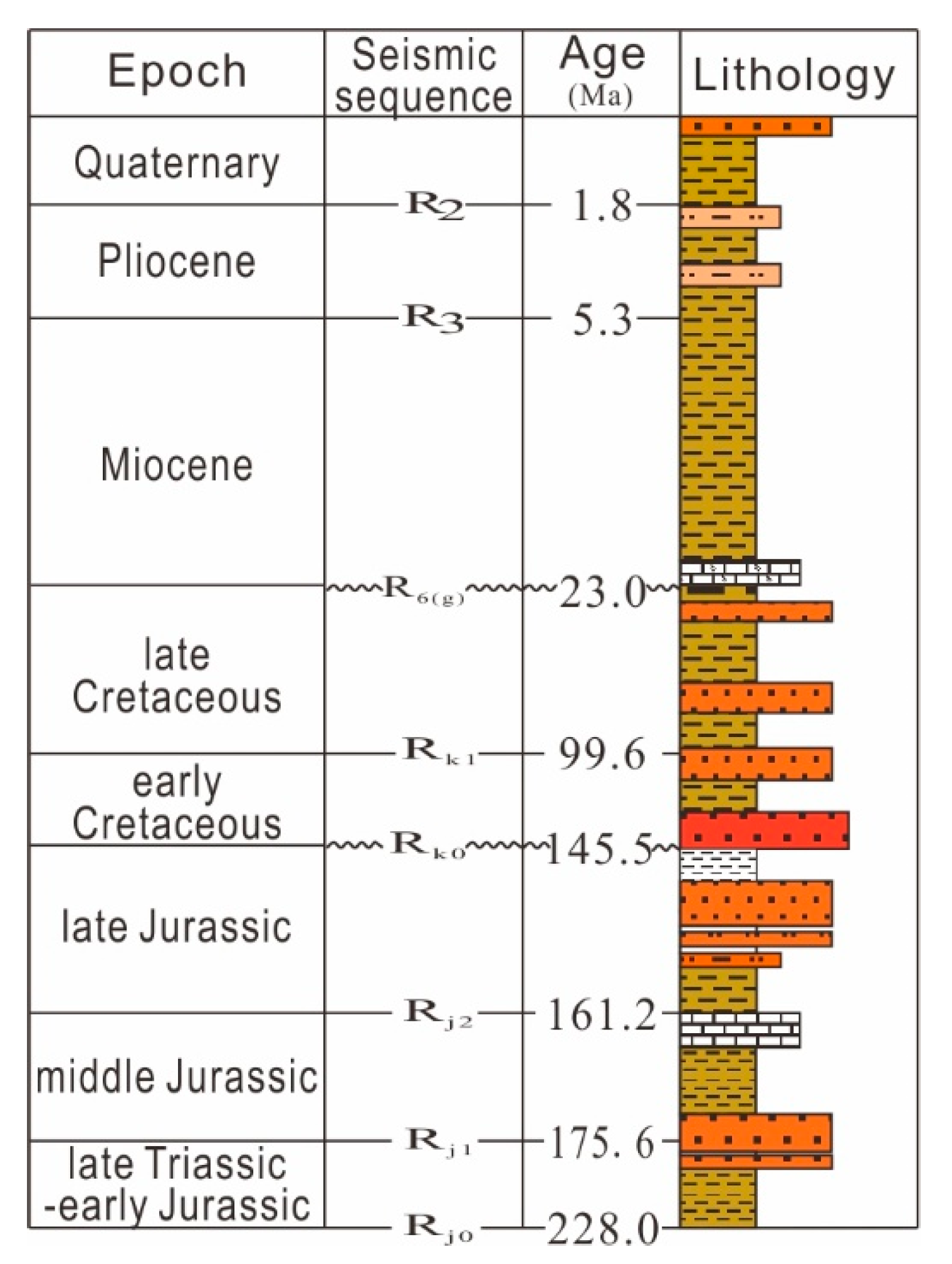
The northeast SCS is located in the central part of the East Asian continental margin, structurally situated on the southern edge of the South China landmass, with the central basin of the Cenozoic SCS to the south; the northern South China Sea has complex rifting, magmatic styles [63]. A large number of geophysical surveys and drillings have confirmed the presence of the marine Mesozoic in the northeast SCS, such as the CFC-1 and CJA-1 wells drilled into the Lower Cretaceous strata [64,65] and the LF35-1-1 well drilled into the Middle Upper Jurassic strata [66,67]; the Mesozoic is widely distributed in the northeast SCS (Figure 1 and Figure 2), with an area of 100,000 km2. The northeast SCS has gone through six stages of tectonic evolution in the Mesozoic and Cenozoic eras, namely, a rifting period (the late Triassic), a depression period (the Jurassic), a tectonic uplift period (the Late Jurassic), a re-subsidence period (the Early Cretaceous), a tectonic inversion period (the Late Cretaceous), and a regional thermal subsidence period (the Neogene). Mesozoic basins have multiple stages of basin formation and transformation and are large, superimposed basins formed by stacking prototype basins with different evolutionary characteristics [68,69,70,71]. The CSD is the largest superimposed depression in the DSWs, distributed in a northeast direction. Structurally, the CSD consists of six secondary units: the northern slope, the central slope, the western slope, the western depression, the eastern depression, and the middle low bulge (Figure 1) [69]. The maximum thickness of its sedimentary layer exceeds 7000 m (Figure 2) [56]. The CSD mainly develops a set of Mesozoic strata, which are mostly in contact with the overlying Cenozoic at an angle. The LF35-1-1 well (completed at a depth of 2412 m) revealed that the strata below 977 m belong to the Mesozoic, with 977 m to 1698 m being the Cretaceous, 1698 m to 2400 m being the Jurassic, and 2400–2412 m being granite. The Cretaceous strata are composed of gray-green, purple-red, gray-purple, and gray-white clastic rocks and comprise a set of fluvial to lacustrine sedimentary layers. The Jurassic strata are composed of gray and gray black sandstone and mudstone, interbedded with oolitic limestone, and are a set of shallow to deep sea sedimentary layers. Fossils of radiolarian combination indicate that the strata (1860–1725 m) were formed in a deep-sea island arc environment, dating back to the Late Jurassic, and fossils of benthic foraminifera indicate that the strata (2112–2049 m) were formed in a shallow tropical marine environment. The fossil assemblage of Kelasuo pollen and Alsophila spores indicates that the strata (2268–2187 m) were formed in a coastal swamp environment, dating from the Middle to Late Jurassic. The granite section is mainly composed of granite and granodiorite intrusions, with the intrusion period mainly occurring in the Late Cretaceous. The CSD has developed two sets of source rocks, namely, the Upper Triassic–Lower Jurassic bathyal facies mudstone and the Upper Jurassic shallow sea shelf mudstone. The source rock conditions are good, and the LF35-1-1 well confirms the existence of marine source rocks [66]. The DSWs are rich in gas hydrates and are a favorable area for the accumulation of gas hydrates [72,73,74,75,76,77,78,79,80,81,82,83,84,85,86,87,88,89,90,91].

3. Data and Methods

3.1. Data Acquisition and Processing

The GMGS has conducted a number of new, long-array seismic surveys in recent years. The 2D seismic streamer has 480 channels spaced 12.5 m apart, and shooting occurs at 37.5 m intervals, using a source capacity of 5080 cubic inches. The coverage is up to 80-fold. Seismic data are processed with routine industry procedures and pre-stacked time migration. The focus is on the suppression of turbulence noise, various random noises, linear interferences, and different types of multiples. With processing, the signals from the shallow, medium, and deep layers are readily discernable, and the wave train characteristics and amplitude characteristics are much clearer than those from previous 2D seismic surveys. This improved seismic imaging poses as an excellent basis for further analysis of complex geological structures. All of the magnetic data used in this study were acquired by the GMGS in recent years.

3.2. Interpretation

Two-dimensional seismic data from an area with a length of about 2000 km were used for this study. The Schlumberger Geoframe Software Platform was used for structural and stratigraphic interpretation of the seismic data. The LF35-1-1 well was selected to provide the stratigraphic and lithological constraints for seismic interpretation. Seven reflecting boundaries were identified based on the recognition of unconformities, reflection terminations, prominent seismic characteristics, and lateral continuity (Figure 3); the interpretation was also controlled by closing loops within the seismic grid to eliminate misties.
Horizon Rg corresponds to the top of the Mesozoic, expressed by erosion of the Mesozoic. Horizon Rg is an unconformable reflection of high amplitude and a laterally continuous reflection, calibrated by the LF35-1-1 well at a depth of 977 m or TWT 1060 ms.
Horizon Rk1 corresponds to the top of the Upper Cretaceous, expressed by erosion of the Lower Cretaceous. Horizon Rk1 is an unconformable reflection of low amplitude and a laterally discontinuous reflection, calibrated by the LF35-1-1 well at a depth of 1369 m.
Horizon Rk0 corresponds to the top of the Jurassic, expressed by erosion of the Jurassic. Horizon Rk0 is an unconformable reflection of medium amplitude and a laterally semi-continuous reflection, calibrated by the LF35-1-1 well at a depth of 1698 m.
The interface Rj2 between J3 and J2 occurs at a depth of 1940 m, calibrated by the LF35-1-1 well, corresponding to a time of 1436 ms. Below the interface is a set of carbonate deposits, and above it is a set of sandstone and mudstone deposits. The upper and lower strata of this interface exhibit an integrated contact relationship, and due to differences in lithology, a strong reflection interface is formed on the seismic profile.
The interface Rj1 between J2 and J1 has not been encountered by this well. However, based on an analysis of the regional sedimentary environment, the upper and lower strata of the interface should be continuous sedimentation and should have undergone a transition from the Late Jurassic semi-deep sea facies to the mid Jurassic coastal shallow sea facies. Therefore, a stable set of semi-deep sea facies mudstone should exist below this interface, with mudstone as the main component above this interface. However, the sandstone content shows a significantly increase, and the upper and lower strata show an integrated contact relationship.
The bottom interface Rj0 of the Upper Triassic shows an unconformity contact relationship between the upper and lower parts of the interface, with a significant difference in seismic velocity compared with the pre-Mesozoic basement.
The upper part of the Mesozoic is the Cretaceous, and the lower part is the Jurassic Upper–Triassic. The Mesozoic exhibits a typical double-layered structure. The Cretaceous is characterized by wedge-shaped, medium-frequency, medium–low-amplitude, and medium continuous seismic facies, with obvious erosion at the top and upward superimposition dominating the bottom. The lower part of the Cretaceous is filled with a set of wedge-shaped alluvial fan sediments, which are lacustrine upward sediments. The Cretaceous has typical fault depression-filling characteristics. The Jurassic is characterized by parallel or sub-parallel, low-frequency, and medium–low continuous seismic facies. This sedimentary body has a relatively stable sedimentary environment and a relatively stable regional distribution, has a non-significant spatial variation in stratigraphic thickness, and is a shallow sea–semi-deep sea–deep sea sediment. An angular unconformity contact occurs between the Cretaceous and Jurassic, and erosion occurs in high parts of the structure. The plate subduction in the Late Jurassic is the reason for the unconformity between the Cretaceous and Jurassic (Figure 3).

4. Results

4.1. Mesozoic Subduction Accretion Wedges and Ancient Suture Lines

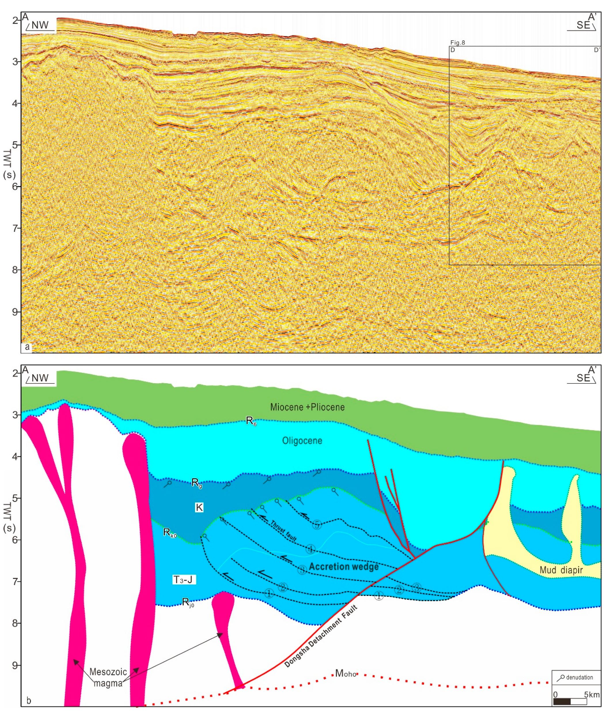
From the deep seismic reflection profile AA’ (Figure 4), typical subduction accretion wedges can be observed. The accretion wedges are composed of stacked thrust faults and structural wedges (①~⑤), which fault the Upper Triassic Jurassic. The detachment layer extends along the bottom of the Upper Triassic, and due to the compression of the structural wedges, strong folding and faulting occur in the Upper Triassic Jurassic (Figure 4). Rk0 and Rg are two important unconformity surfaces, with unconformity contact between the upper and lower strata, and erosion occurring at the top of the Jurassic and Cretaceous. Following the cessation of subduction activity during the Mesozoic era, it underwent a transformation as a result of subsequent tectonic movements. The northwest side of the Dongsha detachment fault had strong folding and compression in the Mesozoic era, while the southeast side had relatively weak deformation in the Mesozoic era. A certain inheritance relationship occurred between the tectonic activity in the Cenozoic era and the structure in the Mesozoic era: before the stretching and thinning in the Cenozoic era, the zone was weak, and the Cenozoic detachment fault developed along the weak zone.
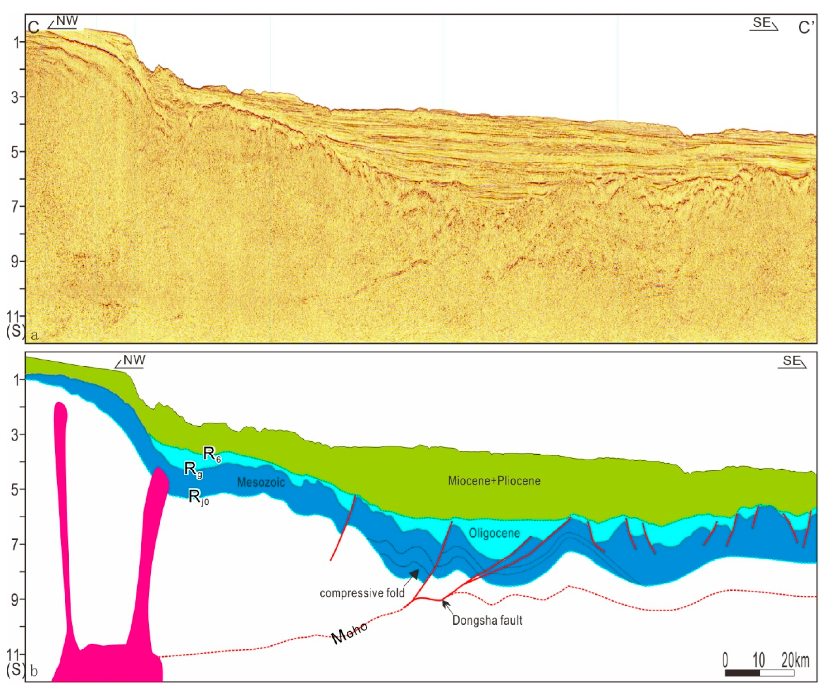
From profile CC’ (Figure 5), we can observe that between 8 s and 11 s, a moderately continuous and strong amplitude seismic reflection interface gradually deepens from southeast to northwest, and the seismic velocity above and below the interface undergoes a sudden change, which is interpreted as a Moho. A large detachment fault, the Dongsha Detachment Fault, developed in the middle of the profile. This fault is an important structural boundary that extends downwards and merges with the Moho. The Moho merges with the detachment fault to form a steep deepening slope break. The slope break zone is also the boundary between the oceanic crust and the continental crust, with the Dongsha detachment fault as the boundary. The northwest section develops a thicker Mesozoic and a thin Cenozoic, which are invaded by rock masses. The maximum crustal thickness exceeds 30 km, and strong folding and compression occur in the Mesozoic near the Dongsha fault; the crustal thickness in the southeast section is relatively thin, with a minimum thickness of less than 10 km. The Dongsha Fault is a large detachment fault deep in the Moho, which is a manifestation of the reactivation of ancient suture lines in the Mesozoic subduction zone during the Cenozoic era (Figure 5).

4.2. Mesozoic Igneous Rocks

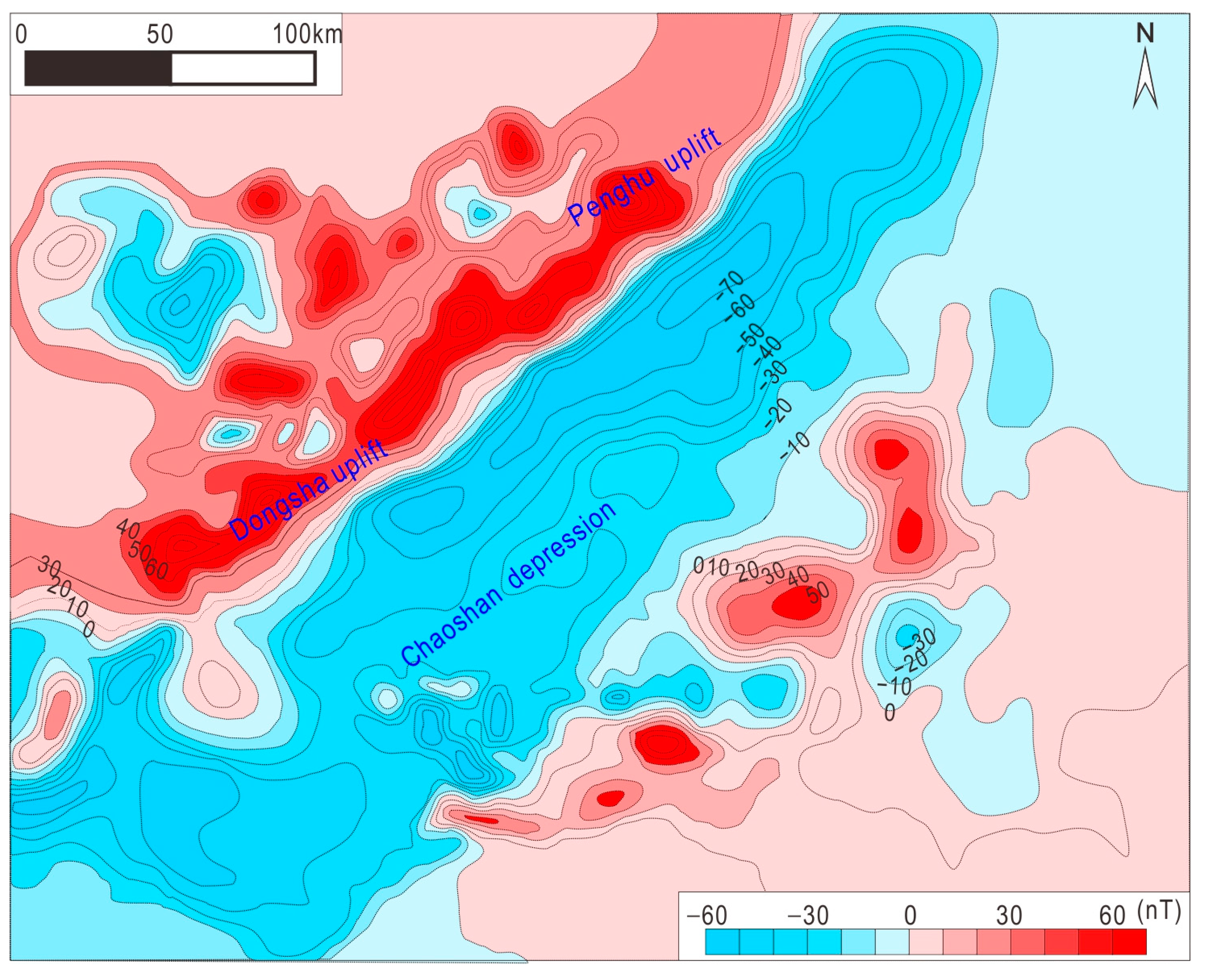
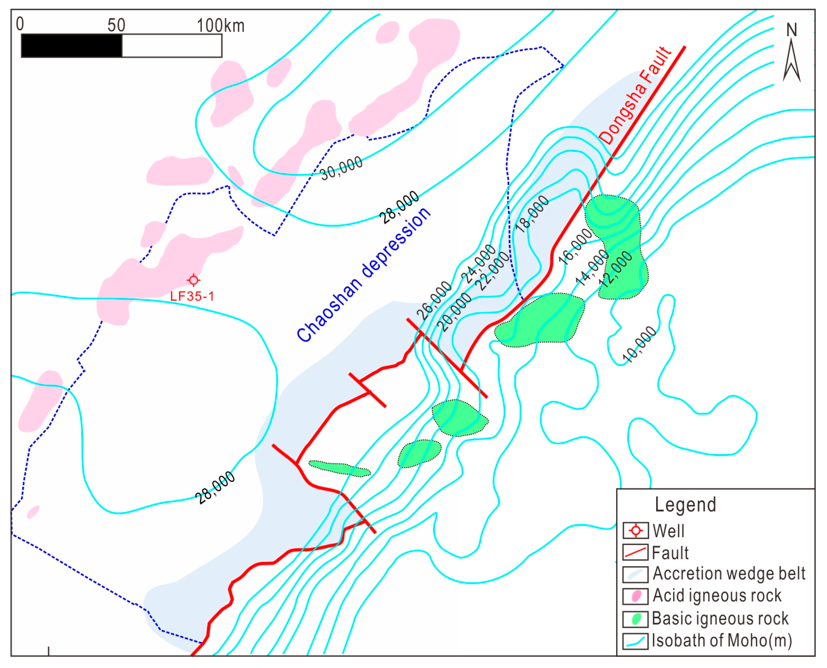
The amplitude of polar magnetic anomalies in the study area ranges from −80 to 250 nT, exhibiting a large number of magnetic anomalies from the Dongsha uplift to the Penghu uplift, forming a northeast-oriented zone with a large number of magnetic anomalies (Figure 6). The CSD is mainly characterized by negative magnetic anomalies, and the southeast CSD also exhibits many magnetic anomalies, but their amplitudes are relatively low. Overall, a clear zoning feature of “high in the north and south, and low in the middle” can be seen (Figure 6). Based on magnetic anomaly wavelet decomposition and seismic interpretation, the distribution of igneous rocks is delineated. The igneous rocks on the northwest side of the CSD have source depths that are mostly greater than 2 km, intrude into the Mesozoic, and are mainly medium acidic, while the igneous rocks on the southeast side of the CSD are mostly exposed to the seabed in the form of eruption and are mainly medium basic; the distribution of igneous rocks in the depression is relatively rare. The Dongsha high magnetic anomaly field is a reflection of the Mesozoic subduction and accretion of intermediate acidic volcanic rocks with high residual magnetic strength (Figure 7), which is the result of the Mesozoic subduction process.
The zircon dating results of LF35-1-1 igneous rocks reveals that the age of the granite at the bottom of the well ranges from 90.7 ± 1.3 to 103.3 ± 1.4 Ma, and the igneous rocks are from the Late Jurassic to the Early Cretaceous. Therefore, we can infer that the initial subduction occurred in the Late Jurassic.

4.3. Mesozoic Mud Diapir Structure

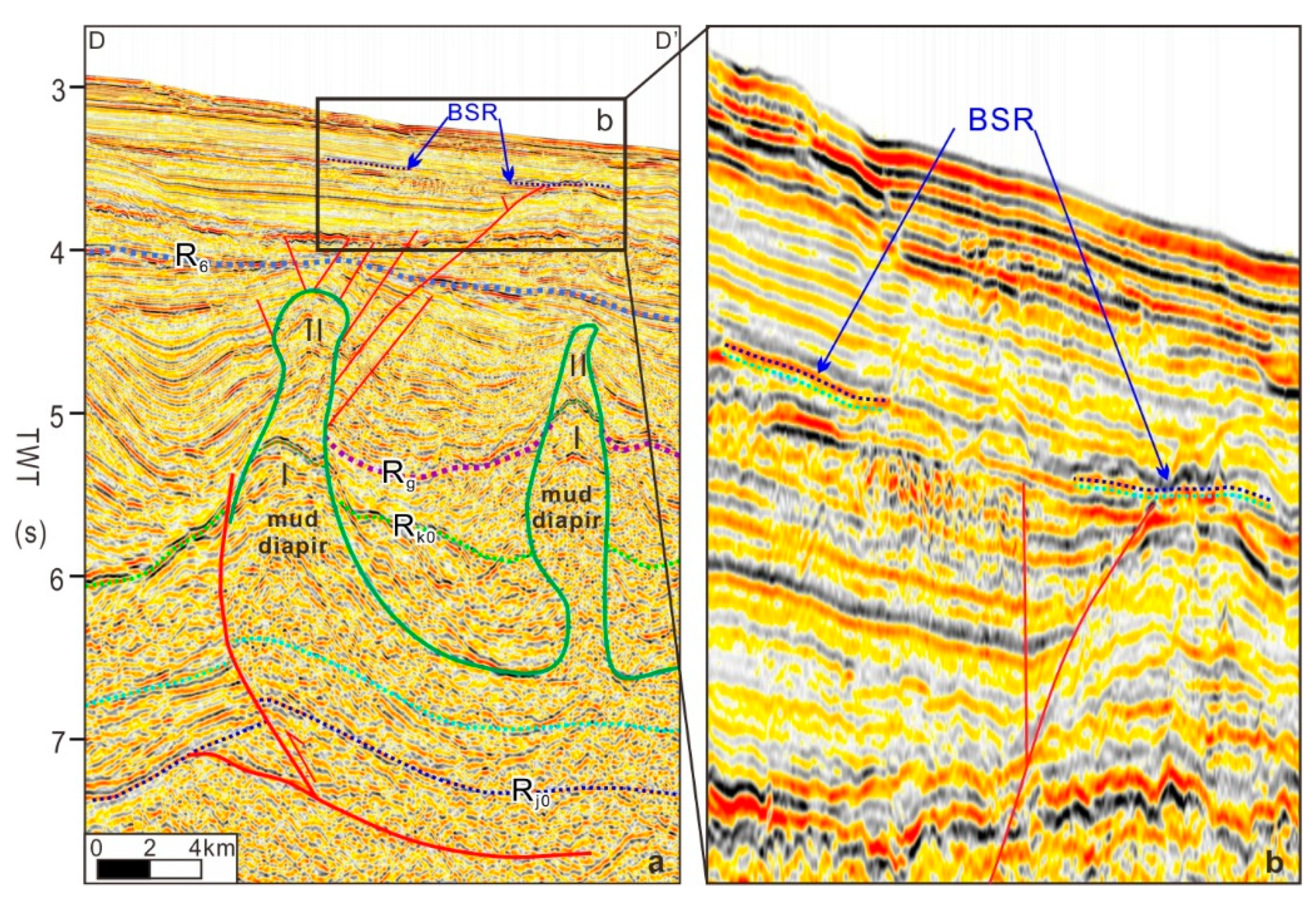
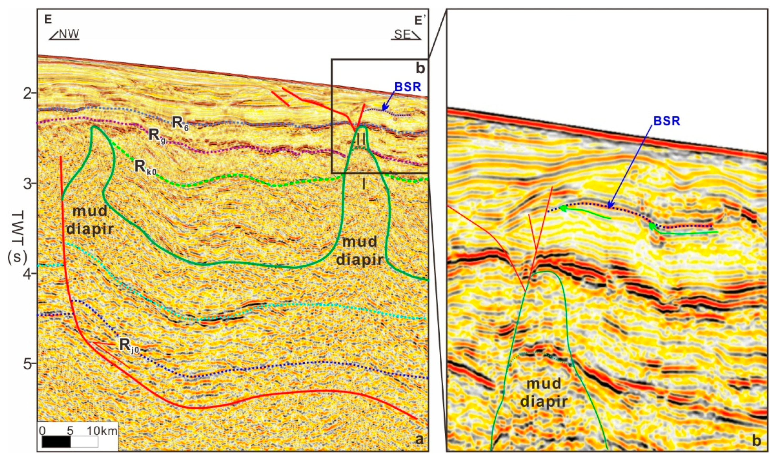
In the seismic profile, the plastic body in the core of the diapir structure exhibits chaotic reflections, which can be completely separated from the reflection of the surrounding rock. The reflection of the surrounding rock strata has good continuity in the same phase axis and stops when it extends to the core. The chaotic reflections in the core significantly thicken and can be traced to both sides, but the thickness rapidly decreases. Due to the intrusion of the diapir structure into the overlying strata, the reflection phase axis of the overlying strata thins towards the top of the mud structure on both wings, reducing the number of phases and accompanying complex fault systems at the top of the structure. Due to the constant velocity of mudstone layers at various depths, a significant difference exists in the velocity between the plastic bodies of the mud diapir structures and the underlying strata, resulting in a large impedance interface difference and strong reflection. In addition, in the seismic profile, the lower mud layer exhibits a medium- to strong-amplitude reflection with good continuity, showing a low-amplitude uplift state (Figure 8 and Figure 9).

5. Discussion

5.1. Properties of Dongsha High-Magnetic-Anomaly Zones

Much debate surrounds the geological origin of the Dongsha high-magnetic-anomaly zone. Dai believed that this high-magnetic-anomaly zone is likely to be the same magmatic tectonic zone as the Zhejiang Fujian coastal volcanic rock zone, which separated from the Zhejiang Fujian coastal volcanic rock zone during the later compression and extension processes [90]. Xia et al. believed that this high-magnetic-anomaly zone is consistent with the thinning of the upper crust, thickening of the lower crust, and uplift of the lower crust [91]. It is not a part of the South China continent or a volcanic arc, but a composite tectonic zone formed by the combined action of Cenozoic tension and pre-Cenozoic compression. The main magnetic source is the ultramafic and magnetic material deep in the lower crust. Wu et al. linked the Penghu uplift and the Diaoyu Islands uplift, suggesting that both may be the Late Cretaceous ancient Ryukyu Island Arc, which was terminated by a NW-trending strike slip fault at 118° to the west [92]. Zhou et al. comprehensively speculated that the high-magnetic-anomaly zone in the northern SCS has the same origin as the volcanic rock belt in the eastern Zhejiang Fujian region, representing a volcanic arc associated with the Mesozoic subduction and accretion, and was left laterally displaced by NW-trending faults [44]. This large amount of magnetic anomaly was formed by a medium acidic “volcanic rock mass” with a thickness of up to 6km. This belt is a crustal remelting magmatic rock belt formed by the collision of continental crustal fragments that migrated northward in the Late Cretaceous and the southeastern edge of the Asian continent. In fact, the magnetic anomaly in the Diaoyu Islands uplift zone is also comparable in shape and scale with the high-magnetic-anomaly zone in the northern SCS. Yao Bochu et al. identified the Dongsha uplift and other volcanic arcs as a reflection of the Jurassic Cretaceous volcanic arc in eastern Asia. Although the genesis of the high-magnetic-anomaly zone in the northern SCS varies, the most common consensus is that it is related to magmatic activity during subduction or collision in the Late Mesozoic [45]. The geochemical characteristics of the intermediate acidic intrusive granite encountered during LF35-1-1 drilling indicate that this zone is an active continental margin island arc environment. Furthermore, paleontological data from the LF35-1-1 well indicate a deep-sea island arc environment during the Late Jurassic [66]. The gravity and magnetic field characteristics of the Dongsha uplift, as well as the inverted lithological characteristics, are similar to the island arc characteristics formed by modern subduction and are comparable [93]. The seismic profile of DSRP2002 highlighted possible Paleo subduction fragments and subduction sutures in the area [16]. Based on the comprehensive characteristics of structure and magnetic anomalies, the high-magnetic-anomaly zone of the Dongsha uplift in the northern SCS can be inferred to be a product of the subduction of the paleo-Pacific. Magnetic materials are mainly located in the upper crust, and the strong magnetic differences on both sides of the boundary under oblique magnetization conditions are the main reason for the formation of the large amount of magnetic anomalies.

5.2. Mesozoic Tectonic Evolution and Subduction Model in the DSWs

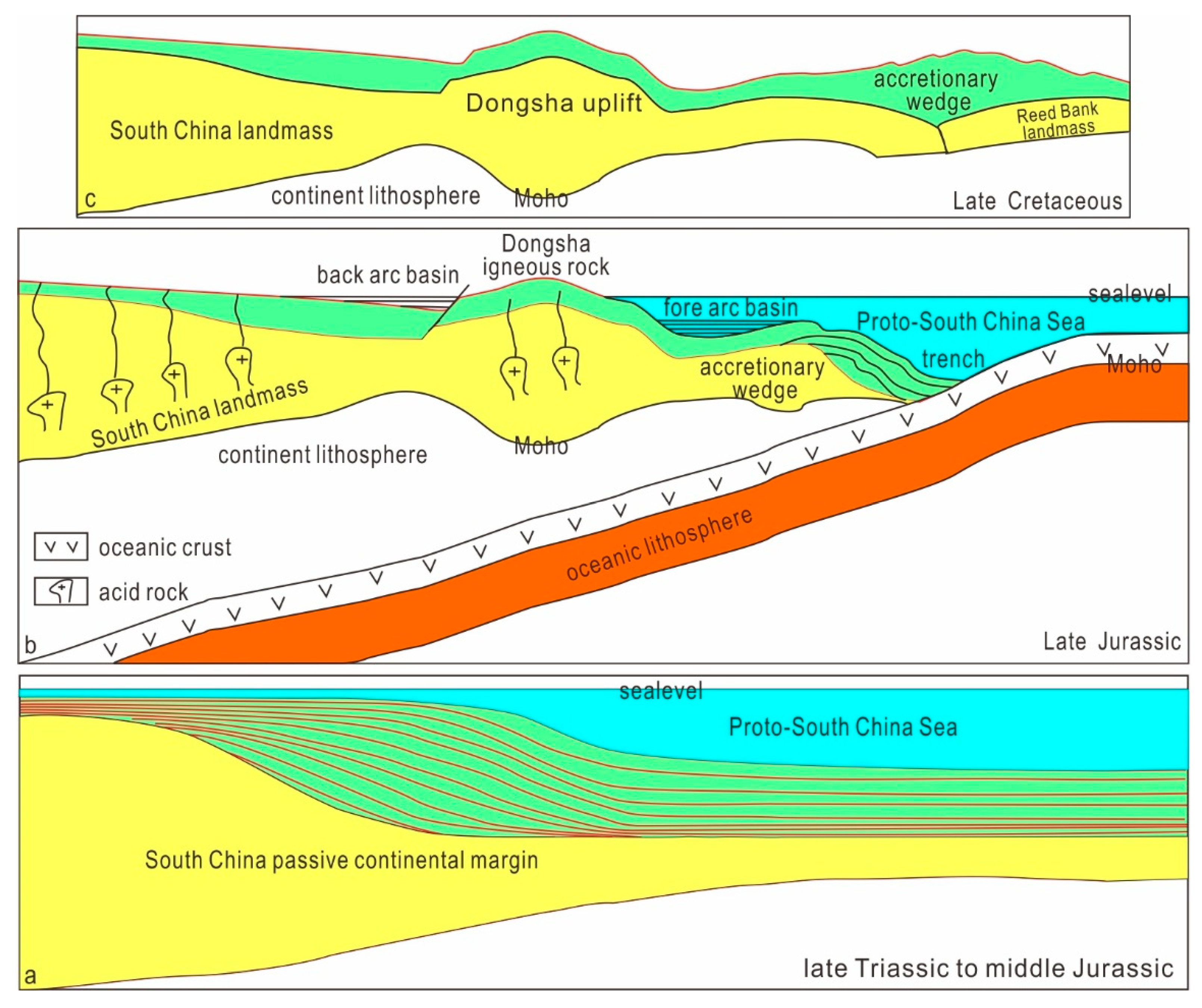
Mesozoic tectonic evolution is closely related to subduction. The DSWs have gone through six stages of tectonic evolution in the Mesozoic and Cenozoic eras, namely, a rifting period (T3), a depression period (J), a tectonic uplift period (J3), a re-subsidence period (K1), a tectonic inversion period (K2), and a regional thermal subsidence period (the Neogene) [93,94,95,96,97,98]. The ancient Pacific lithosphere subducted northwest beneath the lithosphere of the South China continent. In front of the volcanic arc, a forearc basin developed, while behind the volcanic arc, a small post-arc extensional basin developed. In the late Early Cretaceous, the ancient SCS oceanic lithosphere had almost subducted, and the Nansha and South China landmasses collided and continued to compress in the northwest direction (Figure 10). The stratigraphic unconformity between J and K is the result of the Dongsha subduction. The subduction began in the Late Jurassic and collided with the South China landmass during the Late Cretaceous. The northeastern SCS uplifted, and the Middle and Upper Jurassic eroded, forming an angular unconformity interface between the Jurassic and Cretaceous. The evolution of the Dongsha subduction zone can be divided into two stages: (1) in the Late Jurassic, the ancient Pacific plate began to subduct in the NWW direction, and the Dongsha subduction zone already existed as a large subduction zone boundary; (2) in the Late Cretaceous, the subduction continued, and the Reed Bank landmass collided with the South China landmass, causing the ancient SCS to contract and disappear. The corresponding part of the accretion zone has a steep, downward sloping Moho towards the north, with the buried depth of the Moho dropping sharply from 16 km to 26 km. The Dongsha high-magnetic-anomaly zone on the northwest side of the subduction accretion zone is an igneous rock zone that is associated with the Mesozoic subduction.

5.3. Dongsha Subduction Significance in Gas Hydrate Accumulation

5.3.1. Controlling the Gas Source of Hydrate

The Upper Triassic–Lower Jurassic bay sediments and the eastern passive continental margin sediments, as well as the Late Jurassic–Early Cretaceous forearc basins, are important strata for exploring gas hydrates today, such as in the southern part of the Tainan Basin, the CSD, and the Pear River Mouth Basin. Particularly, they are important places for exploring Mesozoic gas hydrates. Affected by subduction, the northern SCS transformed from a passive continental margin during the Late Triassic–Middle Jurassic to an active continental margin during the Late Jurassic. Starting from the Late Triassic, semi-enclosed bay-filling sedimentation began to develop in the Mesozoic basin in the DSWs. At the end of the Late Triassic, the prototype of the basin formed, mainly in an open continental shelf environment. In the Early Jurassic period, the sea invasion further expanded, expanding to the northern part of Guangdong, and the basin entered its peak period; in the late Early Jurassic, a regression occurred, with seawater retreating to the northern SCS and developing coastal and shallow marine sediments. In the late Middle Jurassic, the water gradually deepened, and by the end of the Late Jurassic, it was affected by subduction and uplifted. In the passive continental margin stage, Jurassic semi-enclosed bay source rocks developed. These source rocks have relatively high organic matter contents and abundances compared with open sea source rocks, and their quality is also relatively good. Thus, the main source layers within CSD comprise the T3-J1 and J3 mudstones, especially the thick semi-enclosed bay source rocks, which were found to have fairly high organic matter abundance. In the present era, source rocks have undergone significant maturation and become the gas source foundation for the formation of thermogenic gases. As the deep thermogenic gas interacts with microbial gas, it eventually contributes to gas hydrates [98].

5.3.2. Controlling the Structural Pattern of Hydrate Accumulation

Under the influence of subduction, the CSD formed a structural framework of two depressions and one low bulge under northwest–southeast compressive stress (Figure 1 and Figure 10), and a series of northeast-oriented trap structures were formed in the mid-low bulge. The extensional activity of the northern margin of the SCS in the Cenozoic era was activated along the suture line of the subduction zone, forming the Dongsha detachment fault and controlling the development of the graben. The formation of natural gas hydrate reservoirs in the DSWs is closely related to the Dongsha detachment fault activity. The natural gas overflowing from gas pools within the trap structure is vertically transported to the shallow seabed through faults and micro-cracks and accumulates into hydrates under high-pressure and low-temperature conditions [69,89]. Fluid diapirs are large continuously spreading bright reflection zones in shallow surface layers and are downwards converging high-variance ribbons in middle and shallow layers, all of which are en echelons spreading in the NW–NNW-oriented direction on the plane, with a total area of up to several hundred square kilometers. The profile shows a conical or mushroom-shaped shape that converges from shallow to deep and is characterized by a compound gas chimney fuzzy zone [98].

5.3.3. Controlling the Leakage Channel of Gas Hydrates

During the Cretaceous period, under the westward subduction of the ancient Pacific plate, the plastic mudstone layer in the northern SCS arched upwards under compression, piercing through the overlying rock layers and forming a diapir structure. Affected by subduction, the Mesozoic mudstone softened under high-temperature and -pressure conditions, forming a mud diapir structure by arching upwards. Thus, the mud diapir structure went through two stages of development: (1) At the end of the Cretaceous, the structure was strengthened by the Mesozoic subduction and compression, and the Jurassic mudstone underwent plastic flow, invading the Cretaceous system, forming the stage I mud diapir structure. (2) Under differential gravity caused by the subsidence of the continental slope in the Miocene, the early developed mud diapir structures were reactivated, and the Mesozoic mud diapir invaded the Cenozoic, forming the stage II diapir structure.
Liang et al. believed that there were three genetic models: a diffusion type (pore-filling type), a leakage type (fracture-filling type), and a composite type [78]. In the DSW area, deep gas is regulated by mud diapirs, gas chimneys, and fault systems. During the upward migration of gas, low-flux methane gas forms a diffusion-type hydrate at the bottom of the stability zone, driven by a concentration differential, pressure, and capillary force. Meanwhile, high-flux methane leaks upward in the form of free leakage. It migrates along the fracture and accumulates in the upper part of the stability zone, forming a leakage-type hydrate, which also represents a typical genetic model of a composite type [80].
In fact, many more mud volcanoes have been reported over the DSWs, indicating widespread leakage of oil and gas from the substrates [27,28,35,69,99,100]. The extensional activity of the northern margin of the SCS in the Cenozoic era was activated along the suture line of the subduction zone, forming the Dongsha detachment fault and controlling the development of the graben. The fault fractures of the deep region facilitate communication between the temperature and pressure stability region of the hydrate and the Mesozoic hydrocarbon source rock. Then, the deep thermogenic gas migrates along the transport system to the overlying formation, where it is mixed with the microbial gas, eventually forming hydrates. The fault plays a pivotal role in the process of hydrate accumulation in the region. The Mesozoic fault development area represents the primary seepage area for thermogenic gas [98].
Hydrate stability is, however, a function of pressure, temperature, and concentrations of all hydrate building components in all co-existing phases. Practically, this implies that hydrate can nucleate towards mineral surfaces; hydrate can form from hydrate formers dissolved in water. What is, however, very important is hydrate dissociation towards water that is undersaturated with hydrate former. Hydrates in sediments cannot reach equilibrium [101,102] because there are too many co-existing phases that affect hydrate stability. All over the world, hydrates dissociate continuously due to inflow of seawater (almost no CH4) through fracture systems. In offshore Norway, one example is the Nyegga region [102], in which there are fairly many leakage regions. Even inside a reservoir with several hydrate zones internal movement and changes in fluids may lead to hydrate instability.

6. Conclusions

(1) The Mesozoic subduction zone over the Dongsha Waters (DSWs) of the South China Sea (SCS) is distributed southeast of the CSD in an NE45° direction, and composed of accretion wedges, trenches, and igneous rock zones. The igneous rock formed during the period between the Late Jurassic and the Early Cretaceous.
(2) The evolution of the Dongsha subduction zone can be divided into two stages: ① In the Late Jurassic, the ancient Pacific plate began to subduct in the NWW direction, and the Dongsha subduction zone, as a large subduction zone boundary, already existed. ② In the Late Cretaceous, the subduction continued, and the Reed Bank landmass collided with the South China landmass, causing the contraction and disappearance of the ancient SCS, ultimately forming an igneous rock belt and an accretion wedge system.
(3) Mud diapir and Dongsha detachment fault activity are the main factors controlling the formation of hydrate accumulation in the DSWs. Mud diapir and Dongsha detachment fault activity are the main factors controlling the formation of natural gas hydrate reservoirs in the DSWs. The extensional activity of the northern margin of the SCS in the Cenozoic era was activated along the suture line of the subduction zone, forming the Dongsha detachment fault and controlling the development of the Cenozoic fault depression. The gas source of the hydrate in the DSWs mainly comes from thermogenic gas, which is accompanied by mud diapir activity and migrates along the fault. The gas accumulates to form gas hydrates at the bottom of the stable domain, and BSR can be seen above the mud diapir structure; that is, hydrate deposits are formed under the influence of mud diapir structures, belonging to a typical leakage type genesis model.

Author Contributions

Data processing: K.Z.; writing—original draft preparation: P.S. and Z.Z. All authors have read and agreed to the published version of the manuscript.

Funding

This research was funded by Hainan Province key research and development project (ZDYF2024GXJS002).

Institutional Review Board Statement

Not applicable.

Informed Consent Statement

Not applicable.

Data Availability Statement

Data are available on request from the author.

Acknowledgments

We are grateful for the efforts of all who participated in data acquisition and processing. We thank the reviewers for helpful suggestions that improved the clarity of this paper.

Conflicts of Interest

The authors declare no conflicts of interest.

References

  1. Almeida, J.; Kiel, N.; Rosas, F.M.; Duarte, J.C.; Schellart, W.P. Polarity-reversal subduction zone initiation triggered by buoyant plateau obstruction. Earth Planet. Sci. Lett. 2022, 577, 117195. [Google Scholar] [CrossRef]
  2. Arfai, J.; Franke, D.; Gaedicke, C.; Lutz, R.; Schnabel, M.; Ladage, S.; Berglar, K.; Aurelio, M.; Montano, J.; Pellejera, N. Geological evolution of the West Luzon Basin (South China Sea, Philippines). Mar. Geophys. Res. 2011, 32, 349–362. [Google Scholar] [CrossRef]
  3. Barckhausen, U.; Lngels, M.; Franke, D.; Ladage, S.; Pubellier, M. Evolution of the South China Sea: Revised ages for breakup and seafloor spreading. Mar. Pet. Geol. 2014, 58, 599–611. [Google Scholar] [CrossRef]
  4. Bao, H.; Guo, Z.; Zhang, L.; Huang, Y. Tectonic dynamics of eastern China since the formation of the Pacific Plate. Adv. Earth Sci. 2013, 28, 337–346, (In Chinese with English abstract). [Google Scholar]
  5. Bautista, B.; Bautista, M.; Oike, K.; Wu, F.; Punongbayan, R. A new insight on the geometry of subducting slabs in northern Luzon, Philippines. Tectonophysics 2001, 339, 279–310. [Google Scholar] [CrossRef]
  6. Briai, A.; Patriat, P.; Tapponnier, P. Updated interpretation of magnetic anomalies and seafloor spreading stages in the South China Sea: Implications for the Tertiary tectonics of Southeast Asia. J. Geophys. Res. Solid Earth 1993, 98, 6299–6328. [Google Scholar] [CrossRef]
  7. Camanni, G.; Ye, Q. The significance of fault reactivation on the V1’71SOn Cycle undergone by the northern South China Sea area in the last 60 Myr. Earth Sci. Rev. 2022, 225, 103893. [Google Scholar] [CrossRef]
  8. Hall, H. The subduction initiation stage of the Wilson cycle. Geol. Soc. Lond. Spec. Publ. 2019, 470, 415–437. [Google Scholar] [CrossRef]
  9. Kiss, D.; Candiotti, L.; Duretz, T.; Schmalholz, S. Thermal softening induced subduction initiation at a passive margin. Geophys. J. Int. 2020, 220, 2068–2073. [Google Scholar] [CrossRef]
  10. Lshizuka, O.; Taylor, R.; Ohara, Y.; Yuasa, M. Upwelling, rifting, and age-progressive magmatism from the Oki-Daito mantle plume. Geology 2013, 41, 1011–1014. [Google Scholar] [CrossRef]
  11. Wang, Y.; Wu, S.; Qian, X.; Junaidi, B.A.; Wang, Y.; Zhang, Y.; Feng, Q.; Wang, W.; Zhang, P. Early Triassic-Late Cretaceous Paleo-Pacific subduction zone along the East Asia continental margin: Fore-arc igneous records in Sabah of NE Borneo. China Sci. Bull. 2023, 68, 954–971. (In Chinese) [Google Scholar] [CrossRef]
  12. Antonijevic, S.K.; Wagner, L.S.; Kumar, A.; Beck, S.L.; Long, M.D.; Zandt, G.; Tavera, H.; Condori, C. The role of ridges in the formation and longevity of flat slabs. Nature 2015, 524, 212–215. [Google Scholar] [CrossRef] [PubMed]
  13. Agrusta, R.; Goes, S.; van Hunen, J. Subducting-slab transition-zone interaction: Stagnation, penetration and mode switches. Earth Planet. Sci. Lett. 2017, 464, 10–23. [Google Scholar] [CrossRef]
  14. Chen, C.; Yan, P.; Yu, J.; Zhong, G. Seismically Imaged Crustal Breakup in the Southwest Taiwan Basin of the Northeastern South China Sea Margin. Geochem. Geophys. Geosyst. 2023, 24, e2023GC010918. [Google Scholar] [CrossRef]
  15. Ding, W.; Zhu, R.; Wan, B.; Zhao, L.; Niu, X.; Zhao, P.; Sun, B.; Zhao, Y. Geodynamic processes of the southeastern Neo-Tethys Ocean and the formation mechanism of the curved subduction system in Southeast Asia. Sci. China Earth Sci. 2023, 66, 703–717. [Google Scholar] [CrossRef]
  16. Huang, C.; Zhou, D.; Sun, Z. Deep crustal structure of baiyun sag, northern South China Sea revealed from deep seismic reflection profile. Chin. Sci. Bull. 2005, 50, 1131–1138. Available online: www.scichina.com (accessed on 15 May 2024). [CrossRef]
  17. Hui, Z. Evolution of the Subducting Slab Morphology and its Controlling Factors. Ph.D. Thesis, University of Science and Technology of China, Hefei, China, 1 May 2023. [Google Scholar] [CrossRef]
  18. Ikuhiro, K.; Yusuke, H.; Taro, S. Safe Performance of Track Dilation and Bile Aspiration with ERCP Catheter in EUS-Guided Hepaticogastrostomy with Plastic Stents: A Retrospective Multicenter Study. J. Clin. Med. 2022, 11, 4986. [Google Scholar] [CrossRef]
  19. Luan, X.; Wang, J.; Liu, H.; Zhang, L.; Lu, Y. A Discussion on Tethys in Northern Margin of South China Sea. Earth Sci. 2021, 46, 866–884. [Google Scholar] [CrossRef]
  20. Mar, M.; Qi, J.; Ma, J.; Peng, H.; Lei, L.; Song, Q.; Bai, M. Cenozoic Subsidence History of the Northern South China Sea: Examples from the Qiongdongnan and Yinggehai Basins. Processes 2023, 3, 956. [Google Scholar] [CrossRef]
  21. Peng, G.; Liu, P.; Chen, W.; Li, Z.; Wang, X.; Zhang, Z.; Hao, G. Tectonic Transformation, Magmatic Activity and Subsidence Centre Migration of Eocene Half-Grabens: A Case Study of the Northern Pearl River Mouth Basin (PRMB) in the Northern South China Sea. J. Mar. Sci. Eng. 2023, 3, 579. [Google Scholar] [CrossRef]
  22. Ye, Q.; Mei, L.; Shi, H. The Late Cretaceous tectonic evolution of the South China Sea area: An overview, and new perspectives from 3D seismic reflection data. Earth-Sci. Rev. 2018, 187, 186–204. [Google Scholar] [CrossRef]
  23. Sun, T. A new map showing the distribution of granites in South China and its explanatory notes. Geol. Bull. China 2006, 25, 332–333. [Google Scholar]
  24. Suo, Y.; Li, S.; Peng, G.; Du, X.; Zhou, J.; Wang, C.; Cao, X. Cenozoic basement-involved rifting of the northern South China Sea margin. Gondwana Res. 2023, 120, 20–30. [Google Scholar] [CrossRef]
  25. Tian, Z. Tectonic Property of Proto-South China Sea-Constraints from Petrogeochemistry, Zircon U-Pb Geochronology and Paleomagnetic Evidence from Sabah and Sarawak. Master’s Thesis, Jilin University, Changchun, China, 1 June 2021. [Google Scholar] [CrossRef]
  26. Xing, T.; Zhong, G.; Zhan, W.; Zhao, Z.; Chen, X. Oil-gas reservoir in the Mesozoic strata in the Chaoshan depression, northern South China Sea: A new insight from long offset seismic data. J. Oceanol. Limnol. 2022, 4, 1377–1387. [Google Scholar] [CrossRef]
  27. Yan, P.; Wang, Y.; Liu, J.; Zhong, G.; Liu, X. Discovery of the southwest Dongsha Island mud volcanoes amid the northern margin of the South China Sea. Mar. Pet. Geol. 2017, 88, 858–870. [Google Scholar] [CrossRef]
  28. Yan, Y.; Liao, J.; Yu, J.; Chen, C.; Zhong, G.; Wang, Y.; Wang, L. Velocity Structure Revealing a Likely Mud Volcano off the Dongsha Island, the Northern South China Sea. Energies 2021, 1, 195. [Google Scholar] [CrossRef]
  29. Zhan, H.; Suo, Y.; Zhu, J.; Li, S.; Wang, P.; Wang, G.; Zhou, J.; Wang, X. Closure mechanism of the South China Sea: Insights from subduction initiation along the Manila Trench. Actor Petrol. Sin. 2023, 39, 2569–2582. [Google Scholar] [CrossRef]
  30. Zhu, R.; Yao, Y.; Liu, H.; Xu, Z.; Nie, X.; Du, W. Tectonic Contact Relationship of Continental Margins of the Southwest Sub-Basin, South China Sea in Late Mesozoic. Earth Sci. 2021, 46, 885–898. [Google Scholar] [CrossRef]
  31. Li, W.; Zhou, X. Late Mesozoic subduction zone of southeastern China. Geol. J. China Univ. 1999, 5, 164–169. [Google Scholar]
  32. Li, F.; Sun, Z.; Yang, H. Possible spatial distribution of the Mesozoic volcanic arc in the present-day South China Sea continental margin and its tectonic implications. J. Geophys. Res. Solid Earth 2018, 123, 6215–6235. [Google Scholar] [CrossRef]
  33. Hutchison, C.S. Geology of North-West Borneo: Sarawak, Brunei and Sabah; Oxford University Press: Oxford, UK, 2005. [Google Scholar]
  34. Hutchison, C.S. Oroclines and paleomagnetism in Borneo and south-east Asia. Tectonophysits 2010, 496, 53–67. [Google Scholar] [CrossRef]
  35. Xu, C.; Shi, H.; Barnes, C. Tracing a late Mesozoic magmatic arc along the Southeast Asian margin from the granitoids drilled from the northern South China Sea. Int. Geol. Rev. 2016, X8, 71–94. [Google Scholar] [CrossRef]
  36. Tang, J.; Xu, W.; Wang, F. Subduction history of the Paleo-Pacific slab beneath Eurasian continent: Mesozoic-Paleogene magmatic records in Northeast Asia. Sci. China Earth Sci. 2018, 61, 527–559. (In Chinese) [Google Scholar] [CrossRef]
  37. Breitfeld, H.T.; Davies, L.; Hall, R.; Armstrong, R.; Forster, M.; Lister, G.; Thirlwall, M.; Grassineau, N.; Hennig-Breitfeld, J.; van Hattum, M.W.A. Mesozoic Paleo-Pacific subduction beneath SW Borneo: U-Pb geochronology of the Schwaner granitoids and the pinoh metamorphic group. Front. Earth Sci. 2020, 8, 536. [Google Scholar] [CrossRef]
  38. Gan, C.; Wang, Y.; Barry, T. Spatial and temporal influence of Pacific subduction on South China: Geochemical migration of Cretaceous mafic-intermediate rocks. J. Geol. Soc. 2020, 177, 1013–1024. [Google Scholar] [CrossRef]
  39. Guo, F.; Wu, Y.; Zhang, B. Magmatic responses to Cretaceous subduction and tearing of the Paleo-Pacific plate in SE China: An overview. Earth-Sci. Rev. 2021, 212, 103448. [Google Scholar] [CrossRef]
  40. Metcalfe, I. Multiple Tethyan Ocean basins and orogenic belts in Asia. Gondwana Res. 2021, 100, 87–130. [Google Scholar] [CrossRef]
  41. Gan, C.; Qian, X.; Wang, Y. Late Cretaceous granitoids along the Northern Kuching Zone: Implications for the Paleo-Pacific subduction in Borneo. Lithosphere 2022, 1, 3310613. [Google Scholar] [CrossRef]
  42. Li, Z.; Qiu, J.; Yang, X. A review of the geochronology and geochemistry of Late Yanshanian (Cretaceous) plutons along the Fujian coastal area of southeastern China: Implications for magma evolution related to slab break-off and rollback in the Cretaceous. Earth-Sci. Rev. 2014, 128, 232–248. [Google Scholar] [CrossRef]
  43. Yao, B.; Zeng, W.; Cheng, Y.; Zhang, X. The crustal structure in the eastern part of the northern margin of the South China Sea. Acta Geophys. Sin. 1994, 37, 27–35. [Google Scholar]
  44. Zhou, D.; Wang, W.; Pang, X. Mesozoic subduction-accretion zone in the northeastern South China Sea inferred from geophysical interpretations. Sci. China (Ser. D) 2006, 36, 209–218. [Google Scholar] [CrossRef]
  45. Yao, B.; Zhang, L.; Wei, Z.; Yi, H.; Lin, Z.; Wan, L.; Wang, W.; Qiu, Z.; Li, C. The Mesozoic tectonic characteristics and sedimentary basins in the eastern margin of South China. Mar. Geol. Quat. Geol. 2011, 31, 47–60. [Google Scholar] [CrossRef]
  46. Cai, Q. “The conjecture of residual Tethys”, from the discovery of marine Mesozoic-Paleocene near China. Geol. China 1998, 4, 39–41. [Google Scholar]
  47. Cai, D.; Fenq, X.; Gao, L.; Lianq, J.; Li, Y.; Liu, X.; Duan, J.; Lu, J. Petroleum potential and exploration direction of pre-Tertiary remnant basins in Offshore China. China Offshore Oil Gas 2004, 16, 74–83. [Google Scholar]
  48. Ding, L.; Qasim, M.; Jadoon, I.; Khan, M.; Xu, Q.; Cai, F.; Wang, H.; Baral, U.; Yue, Y. The India-Asia collision in North Pakistan: Insight from the U-Pb detrital zircon provenance of Cenozoic foreland basin. Earth Planet. Sci. Lett. 2016, 455, 49–61. [Google Scholar] [CrossRef]
  49. Ding, L.; Maksatbek, S.; Cai, F.; Wang, H.; Song, P.; Ji, W.; Xu, Q.; Zhang, L.; Muhammad, Q.; Upendra, B. Processes of initial collision and suturing between India and Asia. Sci. China (Earth Sci.) 2017, 60, 635–651. [Google Scholar] [CrossRef]
  50. Ding, W.; Yang, S.; Chen, H.; Cheng, X.; Wu, N. Arc-continent collision orogeny in offshore Taiwan during Neogene. Chin. J. Geol. 2006, 41, 195–201, (In Chinese with English abstract). [Google Scholar]
  51. Ding, W.; Sun, Z.; Dadd, K.; Fang, Y.; Li, J. Structures within the oceanic crust of the central South China Sea Basin and their implications for oceanic accretionary processes. Earth Planet. Sci. Lett. 2018, 488, 115–125. [Google Scholar] [CrossRef]
  52. Eakin, D.; Mcintosh, K.; Van Avendonk, H.; Lavier, L.; Lester, R.; Liu, C.; Lee, C. Crustal-scale seismic profiles across the Manila subduction zone: The transition from intraoceanic subduction to incipient collision. J. Geophys. Res. Solid Earth. 2014, 119, 1–17. [Google Scholar] [CrossRef]
  53. Milkov, A.V.; Sassen, R. Economic geology of offshore gas hydrate accumulations and provinces. Mar. Pet. Geol. 2002, 19, 1–11. [Google Scholar] [CrossRef]
  54. Milkov, A.V. Worldwide distribution of submarine mud volcanoes and associated gas hydrates. Mar. Geol. 2000, 167, 29–42. [Google Scholar] [CrossRef]
  55. Reed, D.L.; Silver, E.A.; Tagudin, J.E. Relations between mud volcanoes, thrust deformation, slope sedimentation, and gas hydrate, offshore north Panama. Mar. Pet. Geol. 1990, 7, 44–54. [Google Scholar] [CrossRef]
  56. Dimitrov, L.I. Mud volcanoes-the most important pathway for degassing deeply buried sediments. Earth Sci. Rev. 2002, 59, 49–76. [Google Scholar] [CrossRef]
  57. Kholodov, V.N. Mud volcanoes, their distribution regularities and genesis: Communication 1. Mud volcanic provinces and morphology of mud volcanoes. Lithol. Miner. Resour. 2002, 37, 197–209. [Google Scholar] [CrossRef]
  58. Yang, X.; Zhong, S.; Wang, Z. The thermodynamics of mud diapir/volcano fluid and its influence on gas hydrate occurrence. Mar. Geol. Front. 2018, 4, 15–23. [Google Scholar] [CrossRef]
  59. Zhang, W.; Liang, J.; He, J.; Cong, X.; Su, P. Characteristics of mud diapir and gas chimney and their relationship with reservoir forming for petroleum and natural gas hydrate on northern slope of the South China Sea. Mar. Geol. Front. 2017, 33, 11–23. [Google Scholar] [CrossRef]
  60. Huang, C.; Chen, K.; Li, S. Periodicities of diapiric rise in the Yinggehai basin. Pet. Explor. Dev. 2002, 29, 44–46. Available online: https://www.semanticscholar.org/paper/Periodicities-of-diapiric-rise-in-the-Yinggehai-Chun/3b39c6e84a9f8cc27976b805f8bf9622c33900e4 (accessed on 29 December 2023). (In Chinese with English abstract).
  61. He, J.; Xia, B.; Zhang, S.; Yan, P.; Liu, H. Origin and distribution of mud diapirs in the Yinggehai basin and their relation to the migration and accumulation of natural gas. Geol. China 2006, 33, 1336–1344. Available online: http://geochina.cgs.gov.cn/geochina/geochinaen/article/abstract/20060617?st=article_issue (accessed on 29 January 2024). (In Chinese with English abstract).
  62. Yan, P.; Wang, Y.; Yu, J.; Luo, W.; Liu, X.; Jin, Y.; Li, P.; Liu, J.; Zhong, G.; Yi, H. Surveying mud volcanoes over the Dongsha Waters in the South China Sea. J. Trop. Oceanogr. 2020, 40, 34–43. [Google Scholar] [CrossRef]
  63. Zhao, Z.; Sun, Z.; Qiu, N.; Zhao, M.; Zhang, J.; Li, F.; Lin, J.; Lee, E. The paleo-lithospheric structure and rifting-magmatic processes of the northern South China Sea passive margin. Gondwana Res. 2023, 120, 162–174. [Google Scholar] [CrossRef]
  64. Zhou, D. Mesozoic strata and sedimentary environment in SW Taiwan basin of the South China Sea and peikang high of Western Taiwan. J. Trop. Oceanogr. 2002, 21, 50–57. Available online: https://www.semanticscholar.org/paper/MESOZOIC-TRATA-AND-SEDIMENTARY-ENVIRONMENTIN-SW-OF-Di/4664810c06970041a510369dd5e303215fdab5be (accessed on 29 March 2024). (In Chinese with English abstract).
  65. He, J.; Xia, B.; Wang, Z.; Sun, D. Petroleum geologic characteristics and exploration base of taixinan basin in eastern area of continental shelf in northern of the South China Sea. Nat. Gas. Geosci. 2006, 17, 345–350. Available online: https://www.semanticscholar.org/paper/PETROLEUM-GEOLOGICCHARACTERISTICS-AND-EXPLORATION-Jia-xiong/ c1b68568f6cdd9a8c19c1eded725c54b84ed2597 (accessed on 20 January 2024). (In Chinese with English abstract).
  66. Shao, L.; You, H.; Hao, H.; Wu, G.; Qiao, P.; Lei, Y. Petrology and depositional environments of Mesozoic strata in the northeastern South China Sea. Geol. Rev. 2007, 53, 164–169. Available online: https://en.cnki.com.cn/Article_en/CJFDTOTAL-DZLP200702004.htm (accessed on 22 March 2024).
  67. Wu, G.; Wang, R.; Hao, H.; Shao, L. Microfossil evidence for development of marine Mesozoic in the north of South China Sea. Mar. Geol. Quat. Geol. 2007, 27, 79–85. Available online: http://jhydz.com.cn/en/article/id/080d7e39-a946-49be-b226-f2c5953be43b (accessed on 12 January 2024). (In Chinese with English abstract).
  68. Zhong, G.; Wu, S.; Feng, C. Sedimentary model of Mesozoic in the northern South China Sea. J. Trop. Oceanogr. 2011, 30, 43–48. Available online: https://en.cnki.com.cn/Article_en/CJFDTOTAL-RDHY201101006.htm (accessed on 20 March 2024). (In Chinese with English abstract).
  69. Zhong, G.; Feng, C.; Wang, Y.; Chen, S.; Sun, M.; Yi, H. Fault bounded models of oil–gas and gas–hydrate accumulation in the Chaoshan depression, the South China Sea. Front. Earth Sci. 2022, 10, 965898. [Google Scholar] [CrossRef]
  70. Zhang, L.; Geng, A.; Wang, L.; Liao, Y.; Xu, G.; Wei, Z. Assessment of Mesozoic source rocks at the Margin of South China Continent. Mar. Geol. Quat. Geol. 2012, 32, 99–108. Available online: http://jhydz.com.cn/en/article/doi/10.3724/SP.J.1140.2012.01099 (accessed on 10 January 2024). [CrossRef]
  71. Hao, H.; Lin, H.; Yang, M.; Xie, H.; Chen, J. The Mesozoic in Chaoshan depression: A new domain of petroleum exploration. China Offshore Oil Gas 2001, 15, 157–163. Available online: https://en.cnki.com.cn/Article_en/CJFDTOTAL-ZHSD200103000.htm (accessed on 15 January 2024). (In Chinese).
  72. Duan, J.; Mi, H. Seismic facies and sedimentary facies study of Mesozoic in Chaoshan sag. Resour. Ind. 2012, 14, 100–105. Available online: http://www.resourcesindustries.net.cn/EN/abstract/abstract2169.shtml (accessed on 19 January 2024). (In Chinese with English abstract).
  73. Han, X.; Yang, K.; Huang, Y. Origin and nature of cold seep in northeastern Dongsha area, the South China Sea: Evidence from chimney-like seep carbonates. Chin. Sci. Bull. 2013, 58, 1865–1873. [Google Scholar] [CrossRef]
  74. Hao, H.; Wang, R.; Zhang, X.; Xie, H.; Chen, Z. Mesozoic marine sediment identification and distribution in the eastern Pearl River Mouth Basin. China Offshore Oil Gas 2004, 16, 84–88. Available online: https://www.semanticscholar.org/paper/Mesozoic-marine-sediment-identification-and-in-the-Petroleum/59300365ddad9383f3ac62aa620adfe674c94d52 (accessed on 27 January 2024).
  75. Hao, H.; Shi, H.; Zhang, X.; Wang, T.; Tang, S. Mesozoic sediments and their petroleum geology conditions in Chaoshan sag: A discussion based on drilling results from the exploratory well LF35-1-1. China Offshore Oil Gas 2009, 21, 151–156. Available online: https://en.cnki.com.cn/Article_en/CJFDTOTAL-ZHSD200903001.htm (accessed on 20 February 2024).
  76. He, J.; Zhong, C.; Yao, Y.; Yan, P.; Wang, Y.; Wan, Z.; Guan, J.; Zhang, J. The exploration and production test of gas hydrate and its research progress and exploration prospect in the northern South China Sea. Mar. Geol. Front. 2020, 36, 1–14. [Google Scholar]
  77. Ji, Z.; Zhao, H.; Wang, H.; Li, C. Mesozoic petroleum system in Chaoshan depression. Pet. Geol. Eng. 2014, 28, 9–15. Available online: http://www.sydzygc.cn/article/id/f8de6c5b-37a5-4db6-8eda-58a9c202bf29 (accessed on 20 April 2024). (In Chinese with English abstract).
  78. Liang, J.; Zhang, G.; Lu, J.; Su, P.; Sha, Z.; Gong, Y.; Su, X. Accumulation characteristics and genetic models of natural gas hydrate reservoirs in the NE slope of the South China Sea. Nat. Gas Ind. 2016, 36, 157–162. [Google Scholar]
  79. Sha, Z.; Xu, Z.; Fu, S.; Liang, J.; Zhang, W.; Su, P.; Lu, H.; Lu, J. Gas sources and its implications for hydrate accumulation in the eastern Pearl River Mouth Basin. Mar. Geol. Quat. Geol. 2019, 39, 116–125. [Google Scholar]
  80. Su, P.; Liang, J.; Fu, S.; Lv, W.G.; Gong, Y. Geological background and accumulation models of gas hydrate reservoir in northern South China Sea. Geol. China 2017, 44, 415–427. [Google Scholar]
  81. Su, P.; Sha, Z.; Chang, S.; Liang, J.; Fu, S. Geological models of gas hydrate formation in the eastern sea area of the Pearl River Mouth Basin. Nat. Gas Ind. 2014, 34, 162–168. [Google Scholar]
  82. Teng, T.; Su, X.; Liu, H.; Cui, H.; Chen, F.; Cheng, S.; Yang, S.; Wang, H.; Liang, J.; Su, P. Archaeal diversity in sediments of core 973-5 from deep-sea cold seep, Dongsha area in South China Sea. Geoscience 2020, 34, 104–116. [Google Scholar]
  83. Wang, P.; Xia, K.; Huang, C. The Mesozoic Marine sediment distribution and Geology-Geophysics characteristic at the North-Eastern of South China Continent. J. Trop. Oceanogr. 2020, 19, 28–35. Available online: https://kns.cnki.net/kcms/detail/detail.aspx?dbcode=CJFD&dbname=CJFD2000&filename=RDHY200004004&uniplatform=NZKPT&v=SSOOogLH9I4fPQOJAHkYL7YYdSD0XwrleHteIOcywdqBscyno6lCU8nVfB-vZ_PQ (accessed on 22 April 2024).
  84. Yang, S.; Tong, Z.; He, Q.; Hao, J. Mesozoic hydrocarbon generation history and igneous intrusion impacts in Chaoshan depression; South China Sea: A case of LF35-1-1 well. China Offshore Oil Gas 2008, 20, 152–156. Available online: https://en.cnki.com.cn/Article_en/CJFDTOTAL-ZHSD200803002.htm (accessed on 27 April 2024).
  85. Zhang, J.; Sun, Z.; Zhang, S. Analysis of Mesozoic tectonic deformation in the Chaoshan depression of Pearl River Mouth Basin. J. Trop. Oceanogr. 2014, 33, 41–49. Available online: http://www.jto.ac.cn/EN/abstract/abstract578.shtml (accessed on 29 April 2024).
  86. Zhang, Q.; Zhang, H.; Jiang, X.; Xu, Y.; Zhou, H. Application of elastic parameters inversion and attribute fusion technology in the “sweet spot” prediction. Nat. Gas Geosci. 2017, 28, 582–588. Available online: http://www.nggs.ac.cn/EN/abstract/abstract4347.shtml (accessed on 10 May 2024). (In Chinese with English abstract).
  87. Zhang, W.; Liang, J.; Lu, J.; Wei, J.; Su, P.; Fang, Y.; Guo, Y.; Yang, S.; Zhang, G. Accumulation features and mechanisms of high saturation natural gas hydrate in Shenhu area, northern South China Sea. Pet. Explor. Dev. 2017, 44, 670–680. [Google Scholar] [CrossRef]
  88. Zhao, Z.; Zhong, G.; Sun, M.; Feng, C.; Tu, G.; Yi, H. Hydrocarbon Accumulation Analysis Based on Quasi-3D Seismic Data in the Turbulent Area of the Northern South China Sea. J. Mar. Sci. Eng. 2023, 11, 338. [Google Scholar] [CrossRef]
  89. Zhong, G.; Su, P.; Feng, C.; Chen, S.; Sun, M.; Yi, H.; Wang, Y.; Yu, J.; Zhao, J.; Zhao, Z. Mesozoic hydrocarbon accumulation model in the Northern South China Sea. IOP Conf. Ser. Earth Environ. Sci. 2022, 1087. [Google Scholar] [CrossRef]
  90. Dai, Q. Analysis of Magnetic Field of China Seas and Adjacent Regions. Mar. Geol. Quat. Geol. 1997, 17, 63–72. [Google Scholar]
  91. Xia, K.; Huanq, C.; Huanq, Z. Upper Triassic-Cretaceous sediment distribution and hydrocarbon potential in South China Sea and its adjacent areas. China Offshore Oil Gas 2004, 16, 73–83. [Google Scholar]
  92. Wu, S.; Liu, W. Tectonics of subduction zone in the East Asia continental margin. Earth Sci. Front. 2004, 11, 15–22. [Google Scholar]
  93. Zhong, G.; Wu, N.; Lin, Z.; Yao, Y.; Yi, H. Characteristics of faults on the northeastern continental slope of the South China Sea and their controls on basin evolution. Geol. China 2008, 35, 456–462. [Google Scholar]
  94. Lin, J.; Xu, M.; Zhou, Z. Ocean drilling investigation of the global subduction processes. Adv. Earth Sci. 2017, 32, 1253–1266, (In Chinese with English abstract). [Google Scholar]
  95. Zhao, M.; Wang, Q.; Yang, F. Seismic survey in Huatung basin and its tectonic significance. Earth Sci. 2021, 46, 359–368, (In Chinese with English abstract). [Google Scholar]
  96. Zhang, J.; Qiu, X.; Zhao, M. Abnormal data retrieval of three-dimensional OBS survey at the Bashi Channel area of the South China Sea. Chin. J. Geophys. 2018, 61, 1529–1538, (In Chinese with English abstract). [Google Scholar]
  97. Qiu, y.; Liu, C.; Peng, G.; Huang, L.; Liang, C.; Li, H.; Wu, Z.; Yang, L. Structural characteristics and development model of fluid diapirs within the structural transition zone, northern South China Sea. Geol. J. 2024, 59, 1906–1923. [Google Scholar]
  98. Feng, C.; Zhong, G.; Sun, M. Analysis of thermogenic gas sources of natural gas hydrates in the Dongsha waters. Front. Earth Sci. 2022, 1, 10. Available online: https://www.frontiersin.org/articles/10.3389/feart.2022.873615/full (accessed on 17 May 2024).
  99. Farahani, M.V.; Hassanpouryouzband, A.; Yang, J.; Tohidi, B. Development of a coupled geophysical–geothermal scheme for quantification of hydrates in gas hydrate-bearing permafrost sediments. Phys. Chem. Chem. Phys. 2021, 23, 24249–24264. [Google Scholar] [CrossRef]
  100. Hassanpouryouzband, A.; Joonaki, E.; Farahani, M.V.; Takeya, S.; Ruppel, C.; Yang, J.; English, N.J.; Schicks, J.M.; Edlmann, K.; Mehrabian, H. Gas hydrates in sustainable chemistry. Chem. Soc. Rev. 2020, 49, 5225–5309. [Google Scholar]
  101. Kvamme, B.; Zhao, J.Z.; Wei, N.; Sun, W.T.; Saeidi, N.; Pei, J.; Kuznetsova, T. Hydrate production philosophy and thermodynamic calculations. Energies 2020, 13, 672. [Google Scholar] [CrossRef]
  102. Kvamme, B.; Vasilev, A. Danube Fan and Nyegga-the largest contrast European gas hydrate deposits for CO2 storing and CH4 and H2 production. Int. J. Greenh. Gas Control 2023, 130, 104014. [Google Scholar] [CrossRef]
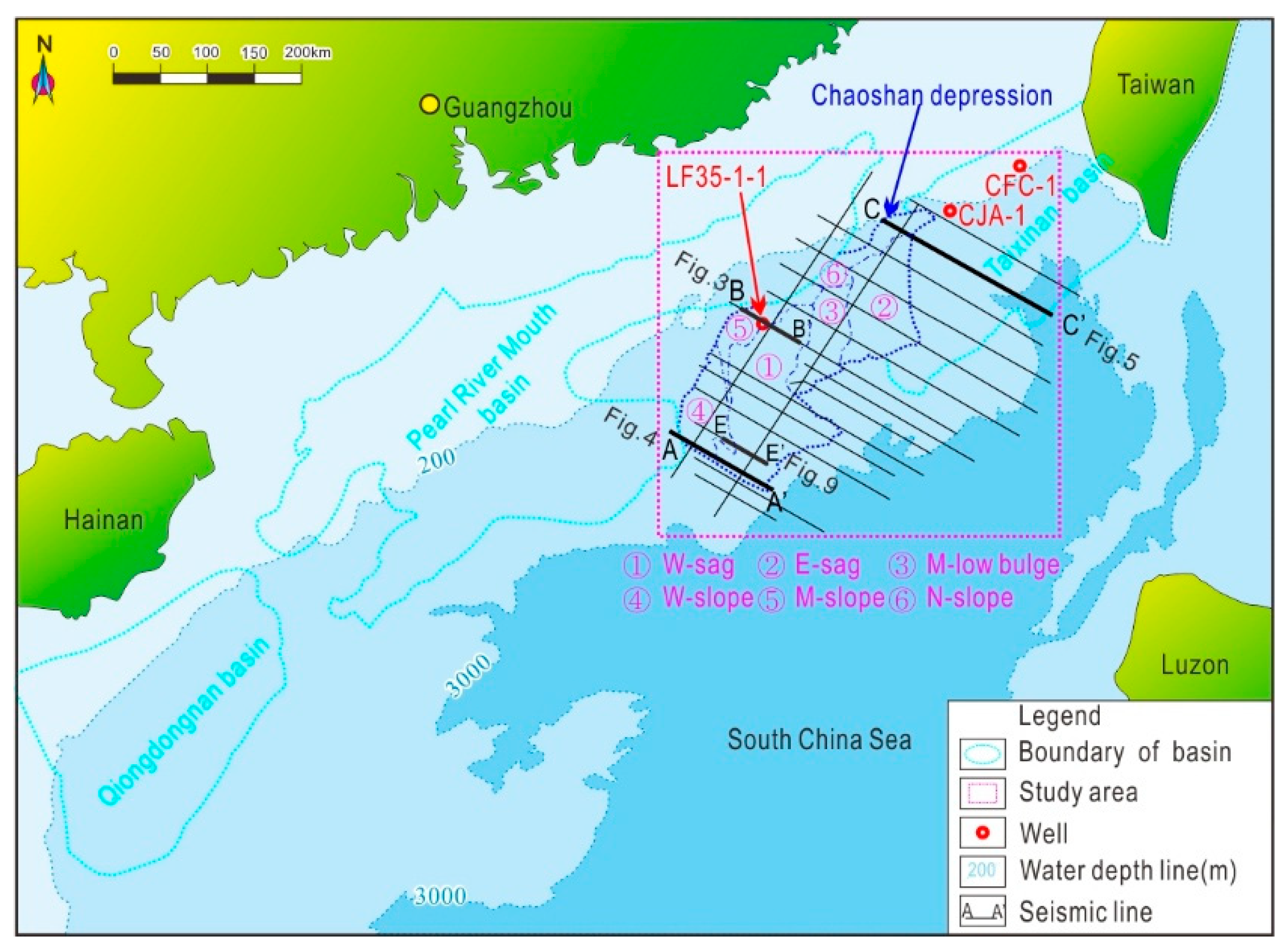
Figure 1. Map of the study area (Location of CSC, and tectonic division. Seismic line used for Isobaths of Moho compiled, and Seismic profiles in the following figures. Location of Well LF35-1-1).
Jmse 12 01432 g001
Figure 2. Stratigraphy of the CSD compiled from Geological data of northern South China Sea and well LF35-1-1, indicating seismic sequence, geological age, and lithology.
Jmse 12 01432 g002
Figure 3. Seismic profile (BB’) across the northern SCS, running from northwest to southeast: (a) well seismic correlation of LF35-1-1; (b) reflecting the boundaries calibrated by synthetic traces (see Figure 1 for the location).
Jmse 12 01432 g003
Figure 4. Seismic profile AA’ across the northern SCS, running from northwest to southeast, showing accretion wedges, mud diapers, and detachment fault ((a) seismic profile; (b) interpretation profile showing erosion at the top of the Jurassic and Cretaceous, accretion wedges, and mud diaper).
Jmse 12 01432 g004
Figure 5. Seismic profile CC’ across the northern SCS, running from northwest to southeast; Moho can be traced distinctly, presenting a laterally semi-continuous reflection ((a) seismic profile; (b) Moho, with a compressive fold and Dongsha fault able to be interpreted).
Jmse 12 01432 g005
Figure 6. A magnetic anomaly map reduced to the magnetic pole.
Jmse 12 01432 g006
Figure 7. Isobaths of Moho and igneous rock distribution.
Jmse 12 01432 g007
Figure 8. Seismic profile DD’ showing a mud diaper ((a) biphasic development of a mud diaper; (b) is the enlargement of box b in the left figure, showing seismic track polarity inversion of BSR (blue line) and normal seismic tracks (green line)).
Jmse 12 01432 g008
Figure 9. Seismic profile EE’ showing a mud diapir ((a) biphasic development of a mud diaper; (b) is the enlargement of box b in the left figure, showing seismic track of a BSR (blue line) and truncated normal seismic tracks (green line)).
Jmse 12 01432 g009
Figure 10. Subduction model of the DSWs. ((a) Passive continental margin period from Late Triassic to Middle Jurassic; (b) primary subduction period during Late Jurassic; (c) collision period during Late Cretaceous).
Jmse 12 01432 g010
Disclaimer/Publisher’s Note: The statements, opinions and data contained in all publications are solely those of the individual author(s) and contributor(s) and not of MDPI and/or the editor(s). MDPI and/or the editor(s) disclaim responsibility for any injury to people or property resulting from any ideas, methods, instructions or products referred to in the content.