
Climate Change and Tidal Hydrodynamics of Guadalquivir Estuary and Doñana Marshes: A Comprehensive Review


 ,
,  ,
,  ,
,  ,
, 
Abstract
1. Introduction
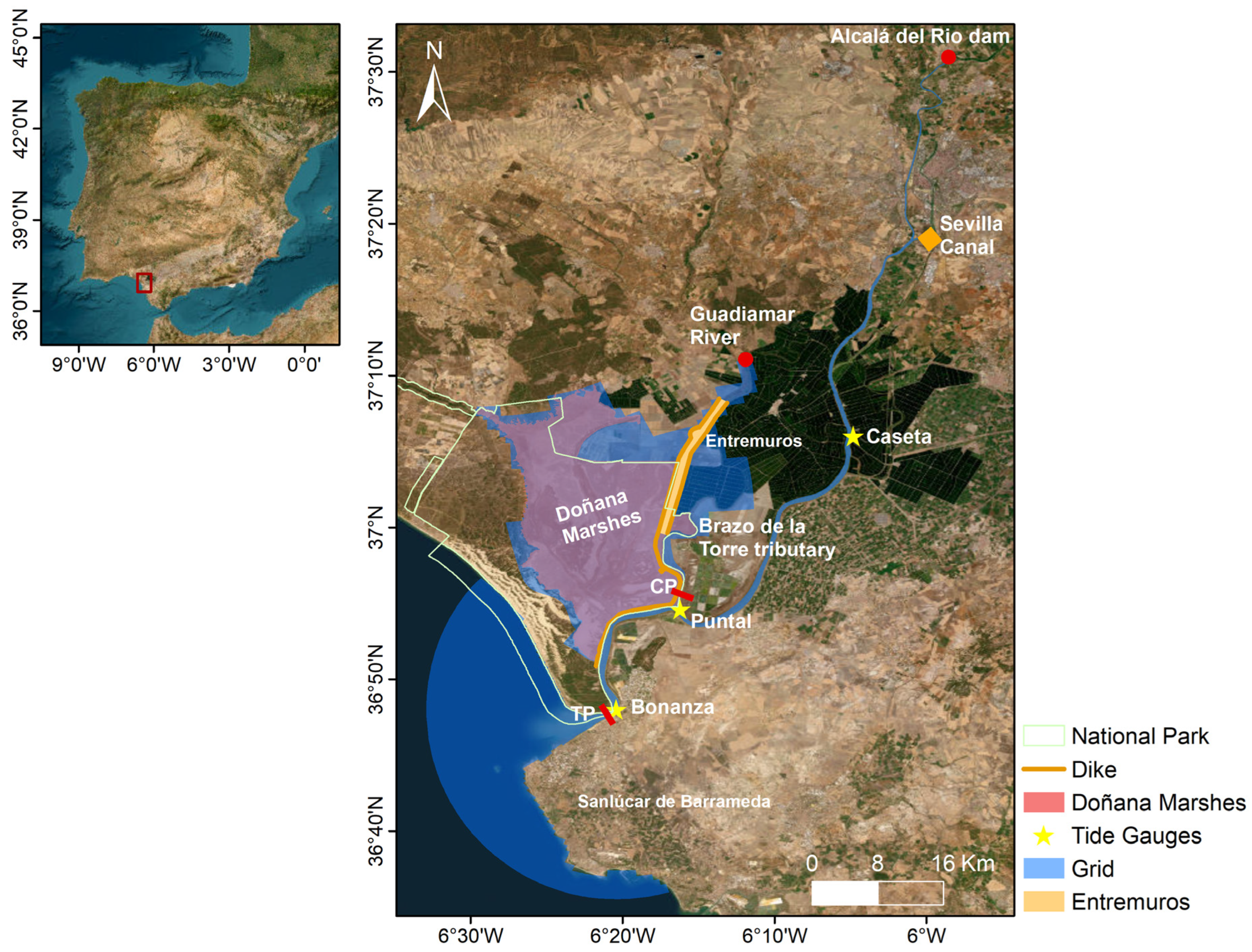
2. Study Area
2.1. Doñana National Park
2.2. Guadalquivir Estuary
2.3. Doñana Marshes
2.4. Aznalcollar Mining Spill (1998)
3. Data and Methods
3.1. Hydrodynamic Model
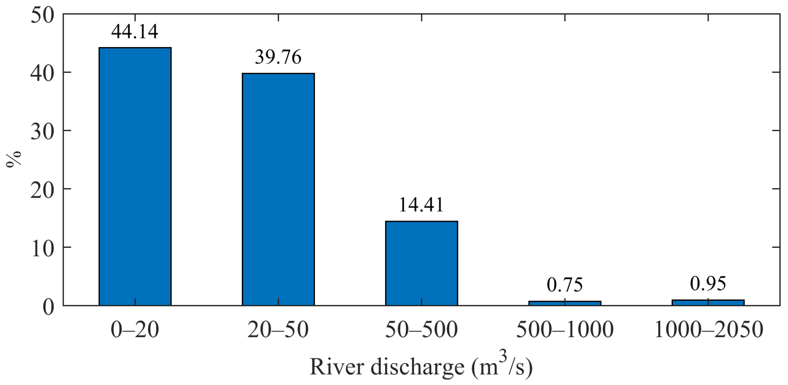
3.2. Simulation Design
4. Hydrodynamic Characterisation of the Guadalquivir Estuary and Doñana Marshes
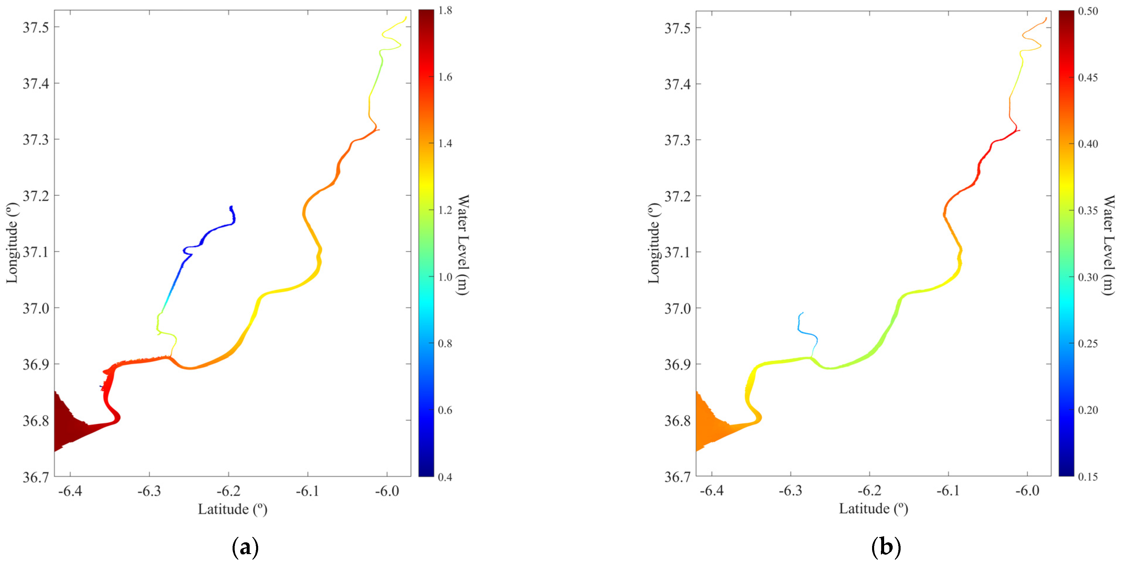
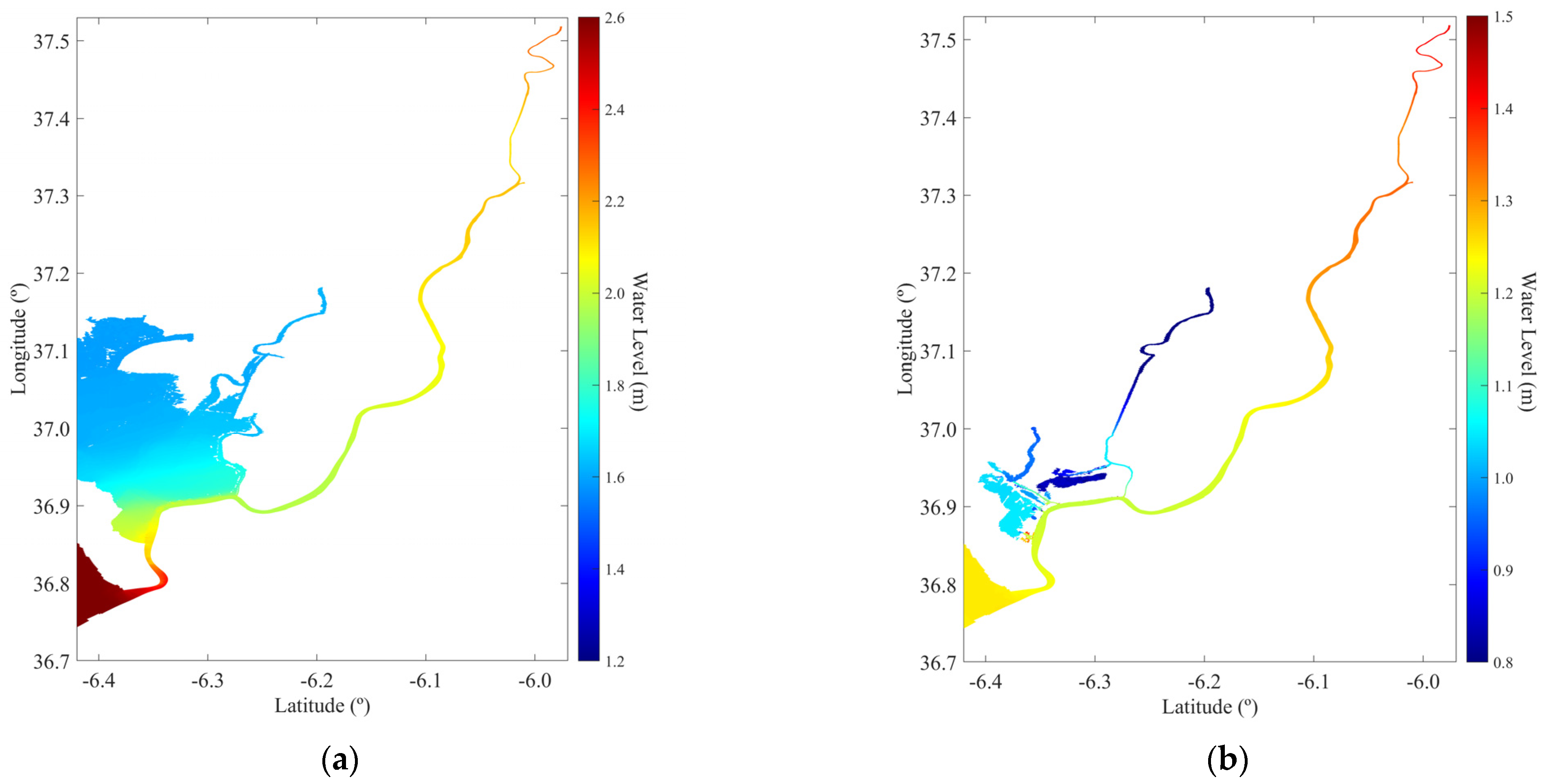
4.1. Maximum Predicted Water Levels
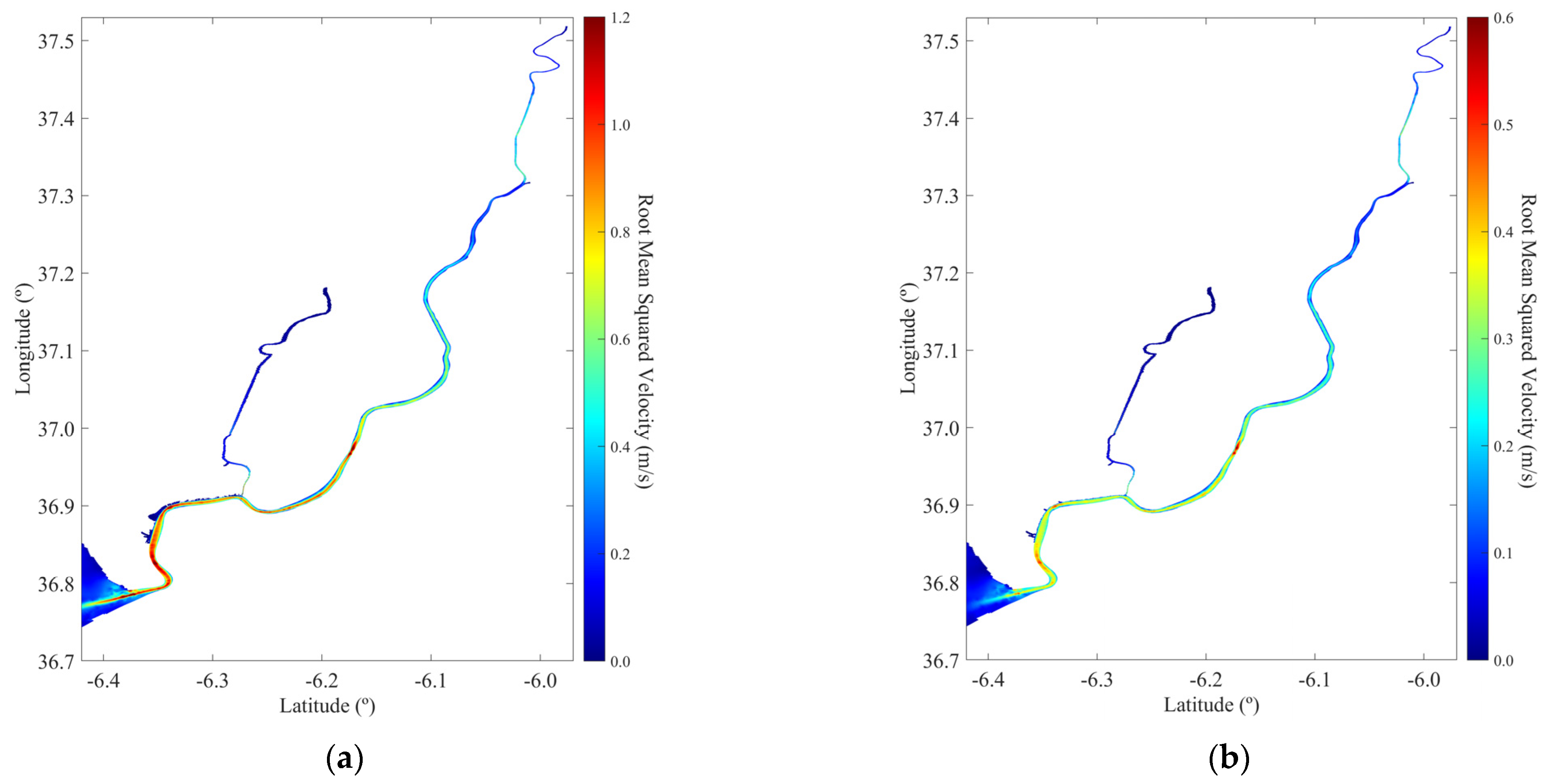
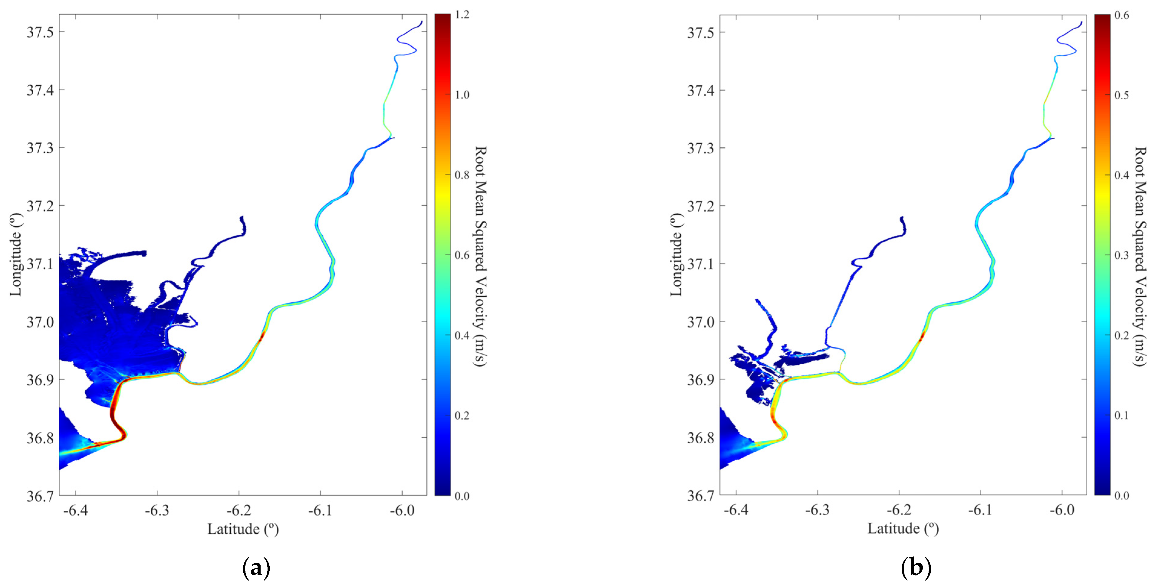
4.2. Root-Mean-Squared Velocity
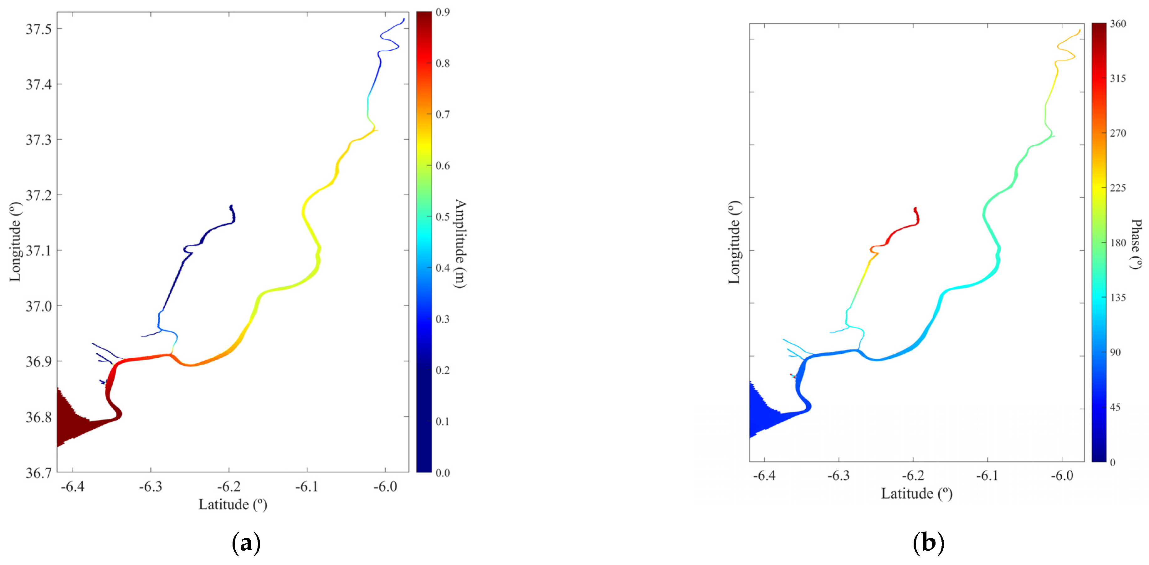
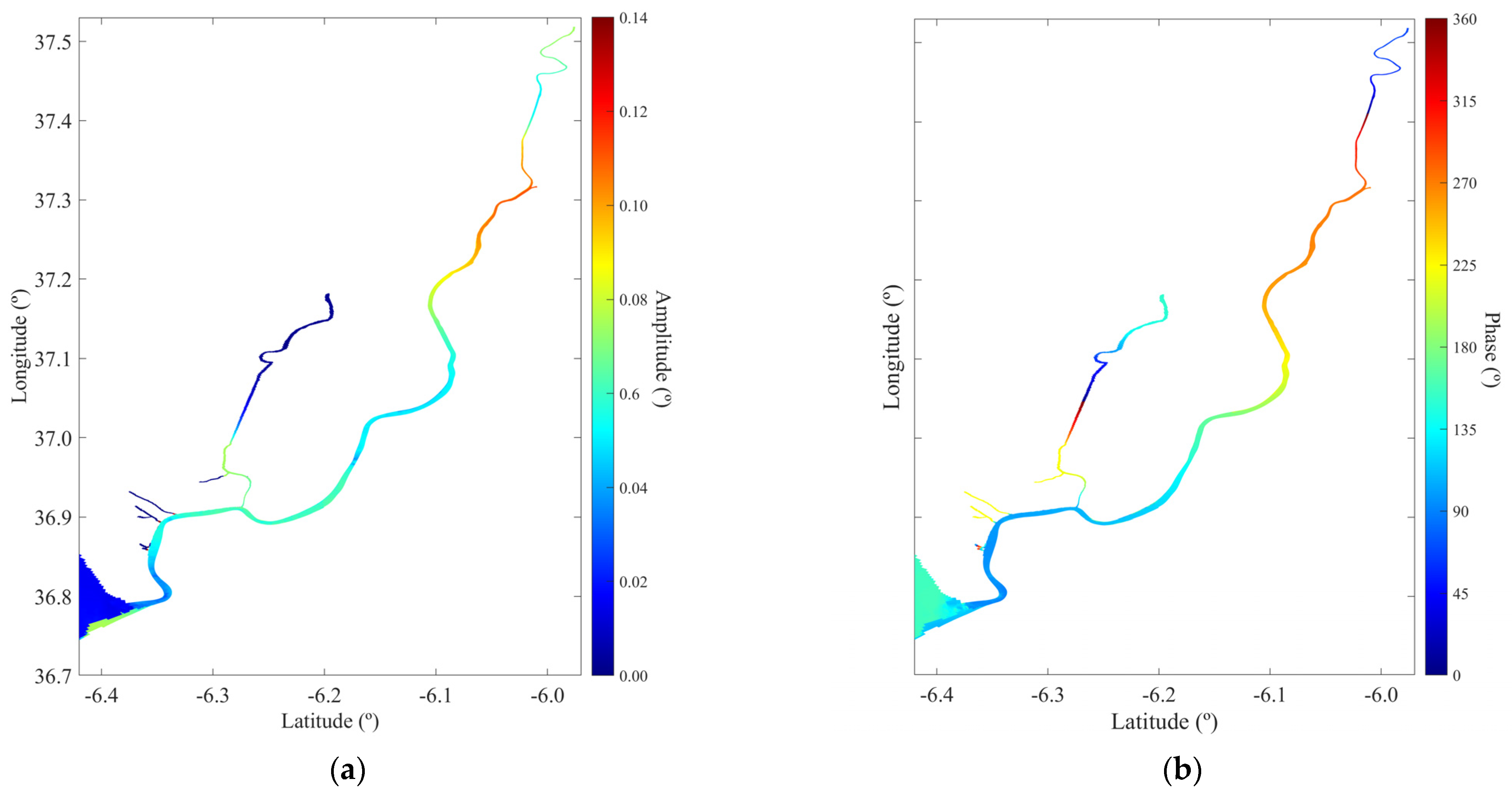
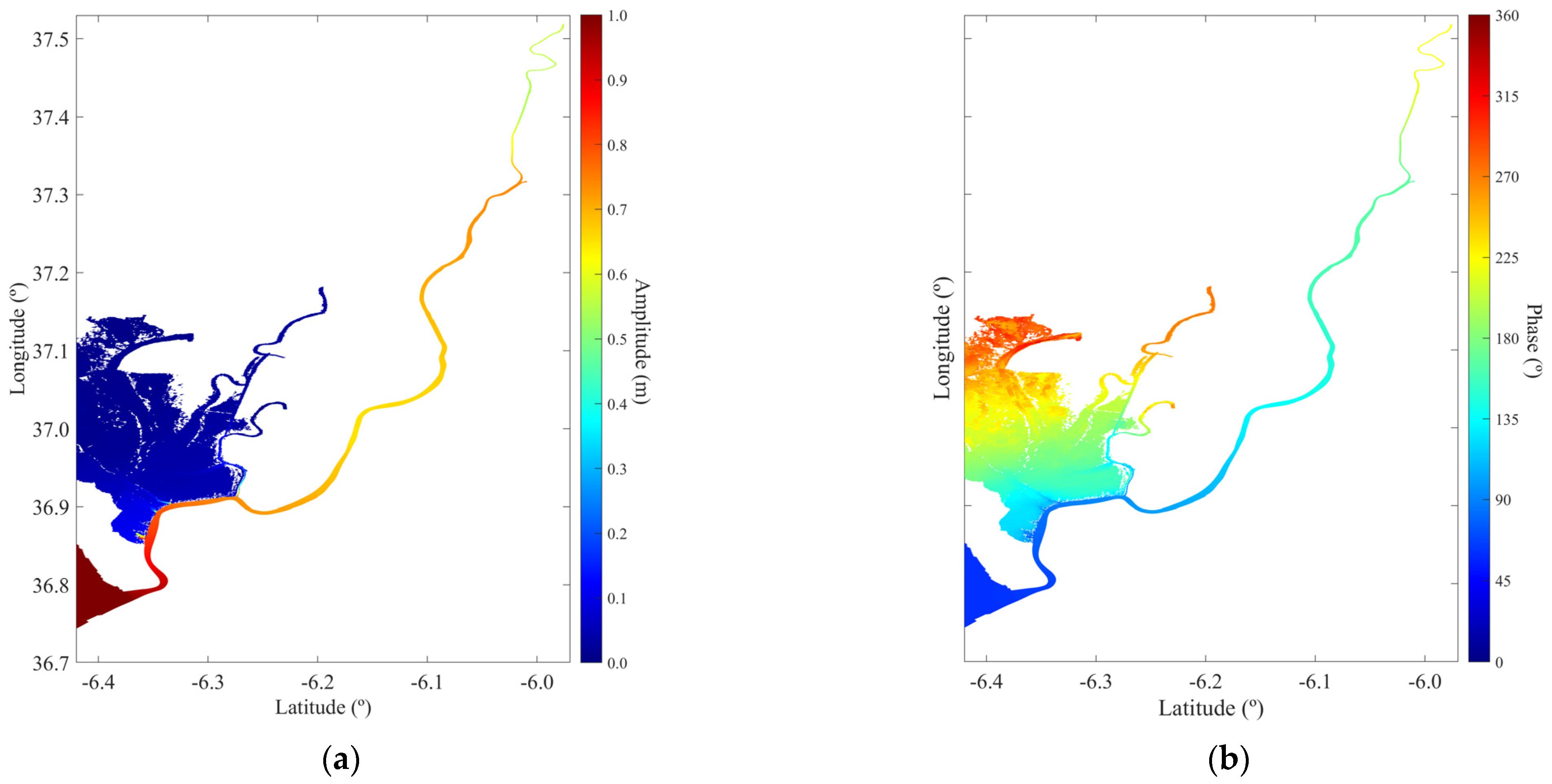
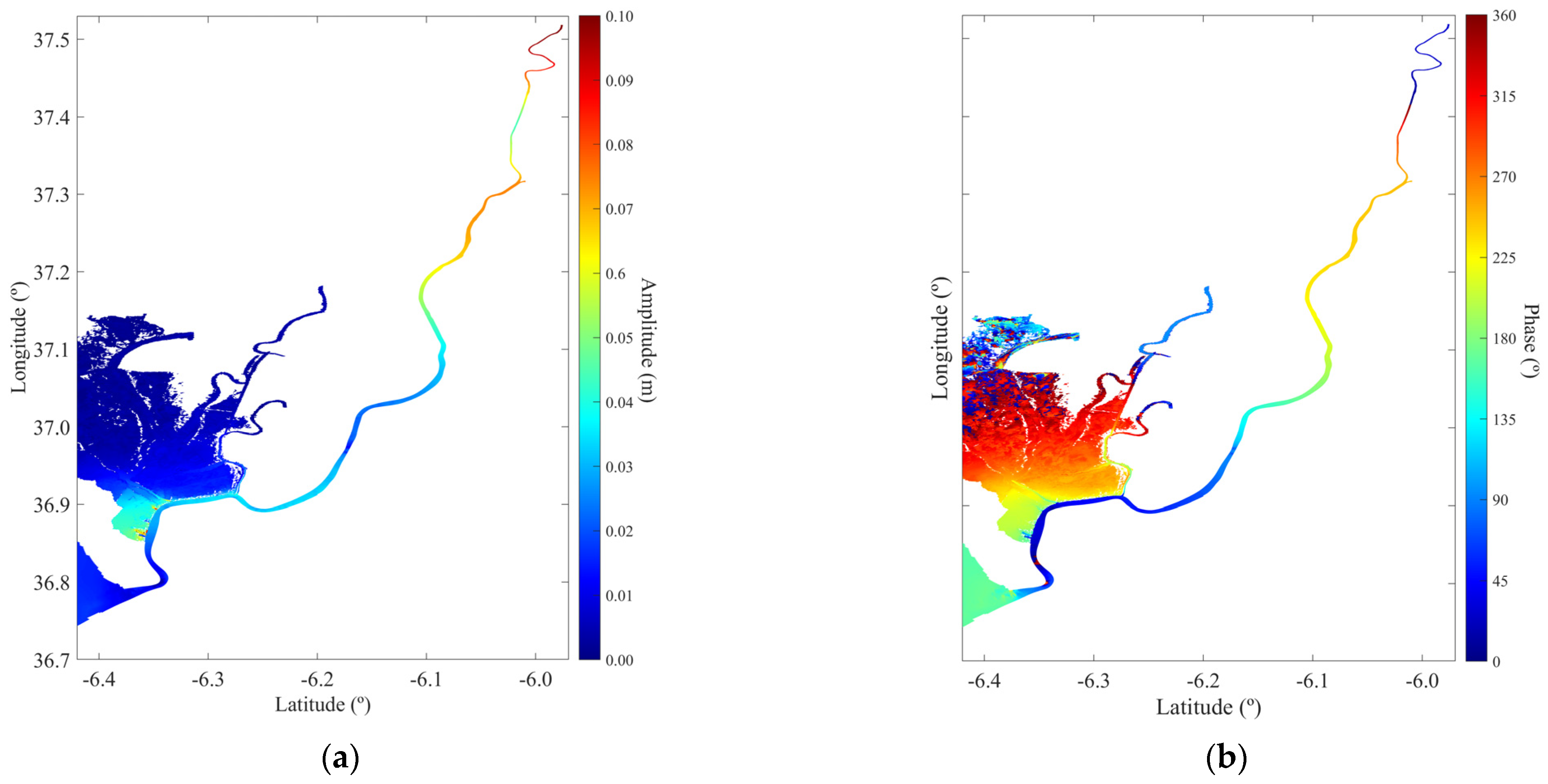
4.3. Harmonic Analysis
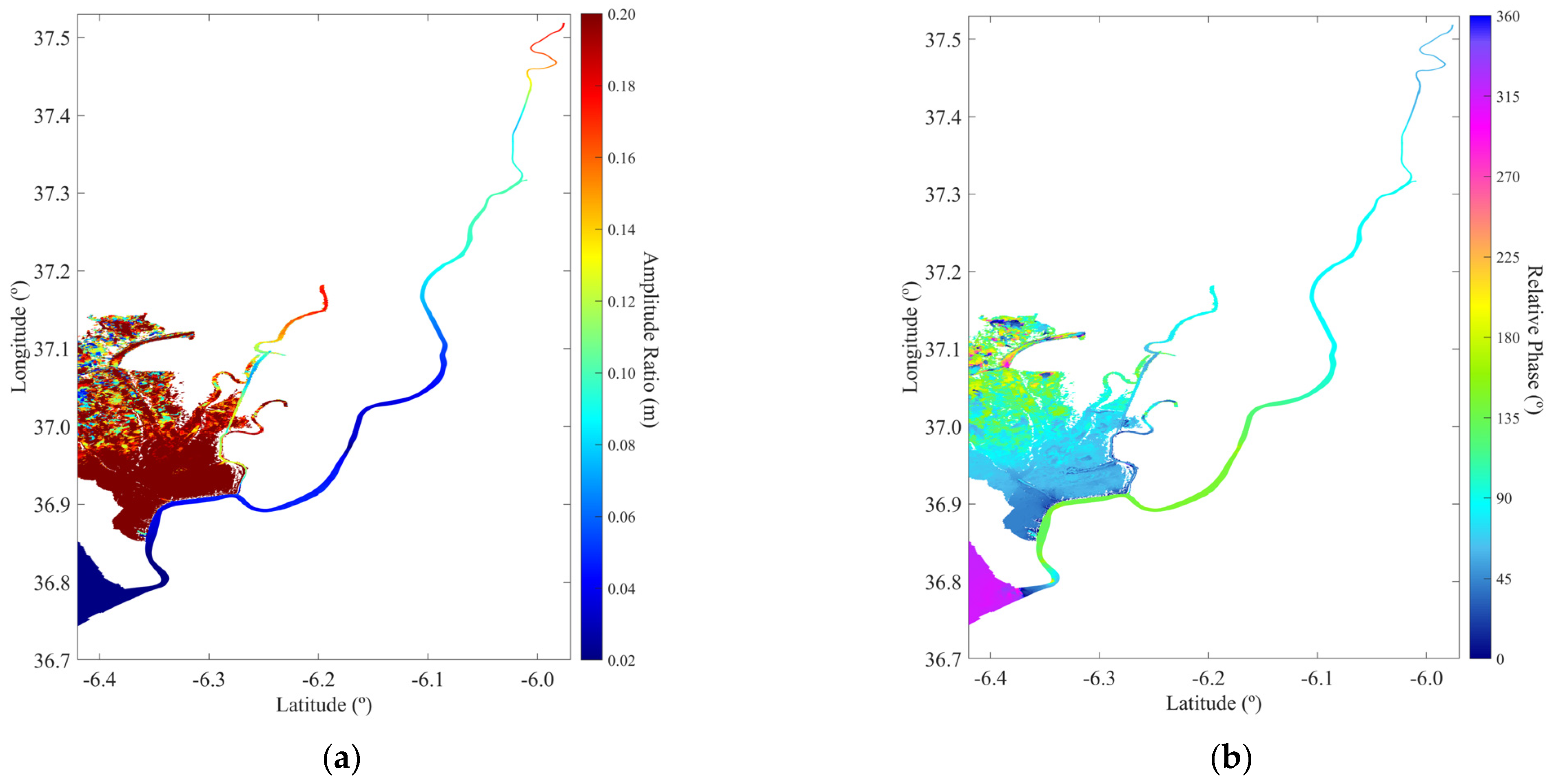
4.4. Tidal Asymmetry
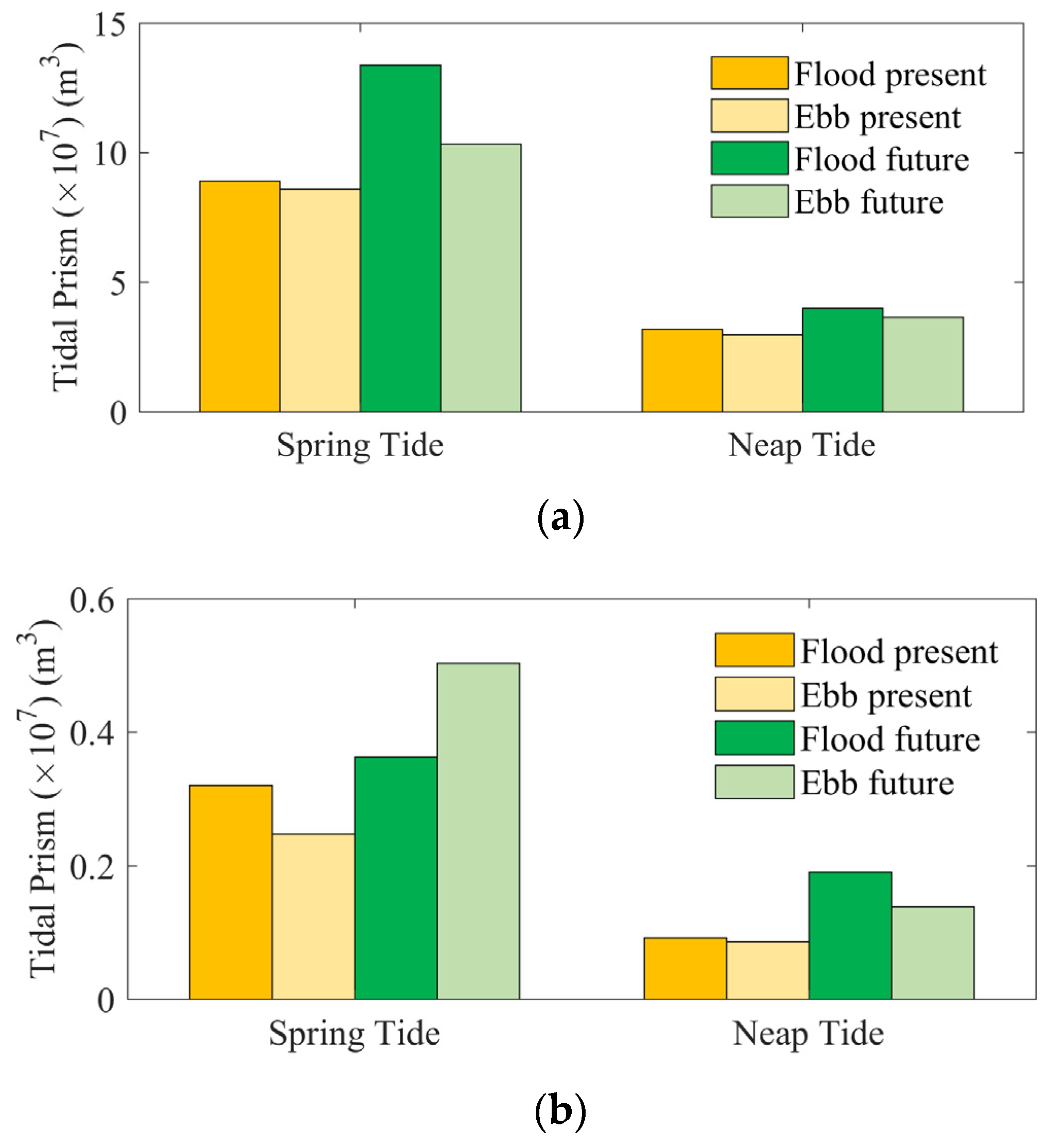
4.5. Tidal Prism
5. Conclusions
Supplementary Materials
Author Contributions
Funding
Institutional Review Board Statement
Informed Consent Statement
Data Availability Statement
Acknowledgments
Conflicts of Interest
References
- Ramsar Convention. An Introduction to the Ramsar Convention on Wetlands, 7th ed.; previously The Ramsar Convention Manual; Ramsar Convention Secretariat: Gland, Switzerland, 2016. [Google Scholar]
- Duarte, C.M.; Losada, I.J.; Hendriks, I.E.; Mazarrasa, I.; Marbà, N. The Role of Coastal Plant Communities for Climate Change Mitigation and Adaptation. Nat. Clim. Chang. 2013, 3, 961–968. [Google Scholar] [CrossRef]
- Barbier, E.B.; Hacker, S.D.; Kennedy, C.; Koch, E.W.; Stier, A.C.; Silliman, B.R. The Value of Estuarine and Coastal Ecosystem Services. Ecol. Monogr. 2011, 81, 169–193. [Google Scholar] [CrossRef]
- Howard, J.; Sutton-Grier, A.; Herr, D.; Kleypas, J.; Landis, E.; Mcleod, E.; Pidgeon, E.; Simpson, S. Clarifying the Role of Coastal and Marine Systems in Climate Mitigation. Front. Ecol. Environ. 2017, 15, 42–50. [Google Scholar] [CrossRef]
- Ray, G.C. The Coastal Realm’s Environmental Debt. Aquat. Conserv. 2006, 16, 1–4. [Google Scholar] [CrossRef]
- Freeman, L.A.; Corbett, D.R.; Fitzgerald, A.M.; Lemley, D.A.; Quigg, A.; Steppe, C.N. Impacts of Urbanization and Development on Estuarine Ecosystems and Water Quality. Estuaries Coast. 2019, 42, 1821–1838. [Google Scholar]
- Ekka, A.; Pande, S.; Jiang, Y.; Van Der Zaag, P. Anthropogenic Modifications and River Ecosystem Services: A Landscape Perspective. Water 2020, 12, 2706. [Google Scholar] [CrossRef]
- Vu, H.L. Anthropogenic Influences on Ecosystem Processes in a Tropical Estuary: Feedback Connections and Environmental Management Targets A Case Study of Dong Ho Estuary, Kien Giang, Vietnam. Master’s Thesis, The University of Queensland, St Lucia, QLD, Australia, 2018. [Google Scholar]
- Llope, M. The Ecosystem Approach in the Gulf of Cadiz. A Perspective from the Southernmost European Atlantic Regional Sea. ICES J. Mar. Sci. 2017, 74, 382–390. [Google Scholar] [CrossRef]
- Ruiz, J.; Polo, M.J.; Díez-Minguito, M.; Navarro, G.; Morris, E.P.; Huertas, E.; Caballero, I.; Contreras, E.; Losada, M.A. The Guadalquivir Estuary: A Hot Spot for Environmental and Human Conflicts. In Coastal Research Library; Springer: Berlin/Heidelberg, Germany, 2015; Volume 8, pp. 199–232. [Google Scholar]
- Almaraz, P.; Green, A.J.; Aguilera, E.; Rendón, M.A.; Bustamante, J. Estimating Partial Observability and Nonlinear Climate Effects on Stochastic Community Dynamics of Migratory Waterfowl. J. Anim. Ecol. 2012, 81, 1113–1125. [Google Scholar] [CrossRef]
- Washington State Department of Ecology Wetlands & Climate Change—Washington State Department of Ecology. Available online: https://ecology.wa.gov/Water-Shorelines/Wetlands/Tools-resources/Wetlands-climate-change (accessed on 13 October 2023).
- Díez-Minguito, M.; Baquerizo, A.; Ortega-Sánchez, M.; Navarro, G.; Losada, M.A. Tide Transformation in the Guadalquivir Estuary (SW Spain) and Process-Based Zonation. J. Geophys. Res. Oceans 2012, 117, C03019. [Google Scholar] [CrossRef]
- Spinosa, A.; Fuentes-Monjaraz, M.A.; El Serafy, G. Assessing the Use of Sentinel-2 Data for Spatio-Temporal Upscaling of Flux Tower Gross Primary Productivity Measurements. Remote Sens. 2023, 15, 562. [Google Scholar] [CrossRef]
- IUCN; UNESCO World Heritage Centre. Ramsar Secretariat Report on the Joint UNESCO/IUCN/Ramsar Reactive Monitoring Mission to Doñana National Park, Spain to 28 February 2020; UNESCO World Heritage Centre: Gland, Switzerland, 2021. [Google Scholar]
- Green, A.J.; Guardiola-Albert, C.; Bravo-Utrera, M.Á.; Bustamante, J.; Camacho, A.; Camacho, C.; Contreras-Arribas, E.; Espinar, J.L.; Gil-Gil, T.; Gomez-Mestre, I.; et al. Groundwater Abstraction Has Caused Extensive Ecological Damage to the Doñana World Heritage Site, Spain. Wetlands 2024, 44, 20. [Google Scholar] [CrossRef]
- Díaz-Delgado, R. Cambio Global En Doñana: Seguimiento y Gestión. En: Los Humedales Costeros de La Península Ibérica. El Desafío Del Cambio Global. In Los Humedales Costeros de la Península Ibérica; Carles, S.I., Carles, I.M., Eds.; Tirant lo Blanch: Valencia, Spain, 2024; pp. 155–186. ISBN 9788411834858. [Google Scholar]
- Sirviente, S.; Sánchez-Rodríguez, J.; Gomiz-Pascual, J.J.; Bolado-Penagos, M.; Sierra, A.; Ortega, T.; Álvarez, O.; Forja, J.; Bruno, M. A Numerical Simulation Study of the Hydrodynamic Effects Caused by Morphological Changes in the Guadalquivir River Estuary. Sci. Total Environ. 2023, 902, 166084. [Google Scholar] [CrossRef]
- Muñoz-Lopez, P.; Nadal, I.; García-Lafuente, J.; Sammartino, S.; Bejarano, A. Numerical Modeling of Tidal Propagation and Frequency Responses in the Guadalquivir Estuary (SW, Iberian Peninsula). Cont. Shelf Res. 2024, 279, 105275. [Google Scholar] [CrossRef]
- Gómez-Enri, J.; Aldarias, A.; Mulero-Martínez, R.; Vignudelli, S.; Bruno, M.; Mañanes, R.; Izquierdo, A.; Fernández-Barba, M. Satellite Radar Altimetry Supporting Coastal Hydrology: Case Studies of Guadalquivir River Estuary and Ebro River Delta (Spain). IEEE J. Sel. Top. Appl. Earth Obs. Remote Sens. 2024, 17, 3587–3599. [Google Scholar] [CrossRef]
- Grimalt, J.O.; Ferrer, M.; Macpherson, E. The Mine Tailing Accident in Aznalcollar. Sci. Total Environ. 1999, 242, 3–11. [Google Scholar]
- Junta de Andalucía Guía Del y Su Entorno Espacio Natural de Doñana, Seville, Spain, 2008; Volume 1a.
- Gil, I.N.; de Mora, A.S.; Rodríguez, M.S.; Buzón, M.M. Donana y La Marisma. In Programa de Educación Ambiental, Cuaderno de Campo; Junta de Andalucía, Consejería de Medio Ambiente: Sevilla, Spain; pp. 1–48. ISBN 978-84-96776-87-6.
- Siljeström, P.A.; Moreno, A.; Garcia, L.V.; Clemente, L.E. Doñana National Park (South-West Spain): Geomorphological Characterization through a Soil-Vegetation Study. J. Arid. Environ. 1994, 26, 315–323. [Google Scholar]
- Rodríguez-Ramírez, A.; Yáñez-Camacho, C.M. Formation of Chenier Plain of the Doñana Marshland (SW Spain): Observations and Geomorphic Model. Mar. Geol. 2008, 254, 187–196. [Google Scholar] [CrossRef]
- Barroso, P.; Acevedo, P.; Risalde, M.A.; García-Bocanegra, I.; Montoro, V.; Martínez-Padilla, A.B.; Torres, M.J.; Soriguer, R.C.; Vicente, J. Co-Exposure to Pathogens in Wild Ungulates from Doñana National Park, South Spain. Res. Vet. Sci. 2023, 155, 14–28. [Google Scholar] [CrossRef]
- Gómez-Rodríguez, C.; Díaz-Paniagua, C.; Bustamante, J. Cartografía de Lagunas Temporales Del Parque Nacional de Doñana. 2011. Available online: https://www.researchgate.net/publication/236586598_Cartografia_de_lagunas_temporales_del_Parque_Nacional_de_Donana (accessed on 14 August 2024).
- Donázar-Aramendía, I.; Sánchez-Moyano, J.E.; García-Asencio, I.; Miró, J.M.; Megina, C.; García-Gómez, J.C. Maintenance Dredging Impacts on a Highly Stressed Estuary (Guadalquivir Estuary): A BACI Approach through Oligohaline and Polyhaline Habitats. Mar. Environ. Res. 2018, 140, 455–467. [Google Scholar] [CrossRef]
- Díez-Minguito, M.; Baquerizo, A.; Ortega-Sánchez, M.; Ruiz, I.; Losada, M.A. Tidal Wave Reflection from the Closure Dam in the Guadalquivir Estuary (SW Spain). Coast. Eng. Proc. 2012, 1, 58. [Google Scholar] [CrossRef]
- Lee, J.; Biemond, B.; de Swart, H.; Dijkstra, H.A. Increasing Risks of Extreme Salt Intrusion Events across European Estuaries in a Warming Climate. Commun. Earth Environ. 2024, 5, 60. [Google Scholar] [CrossRef]
- García-Lafuente, J.; Delgado, J.; Navarro, G.; Calero, C.; Díez-Minguito, M.; Ruiz, J.; Sánchez-Garrido, J.C. About the Tidal Oscillations of Temperature in a Tidally Driven Estuary: The Case of Guadalquivir Estuary, Southwest Spain. Estuar. Coast. Shelf Sci. 2012, 111, 60–66. [Google Scholar] [CrossRef]
- Díez-Minguito, M.; Baquerizo, A.; De Swart, H.E.; Losada, M.A. Structure of the Turbidity Field in the Guadalquivir Estuary: Analysis of Observations and a Box Model Approach. J. Geophys. Res. Oceans 2014, 119, 7190–7204. [Google Scholar] [CrossRef]
- Díaz-Delgado, R.; Aragonés, D.; Afán, I.; Bustamante, J. Long-Term Monitoring of the Flooding Regime and Hydroperiod of Doñana Marshes with Landsat Time Series (1974–2014). Remote Sens. 2016, 8, 775. [Google Scholar] [CrossRef]
- Huertas, I.E.; Flecha, S.; Figuerola, J.; Costas, E.; Morris, E.P. Effect of Hydroperiod on CO2 Fluxes at the Air-Water Interface in the Mediterranean Coastal Wetlands of Doñana. J. Geophys. Res. Biogeosci. 2017, 122, 1615–1631. [Google Scholar] [CrossRef]
- Huertas, I.E.; de la Paz, M.; Perez, F.F.; Navarro, G.; Flecha, S. Methane Emissions from the Salt Marshes of Doñana Wetlands: Spatio-Temporal Variability and Controlling Factors. Front. Ecol. Evol. 2019, 7, 32. [Google Scholar] [CrossRef]
- García-Luque, E.; Forja, J.M.; Delvalls, T.A.; Gómez-Parra, A. The Behaviour of Heavy Metals from the Guadalquivir Estuary after the Aznalcóllar Mining Spill: Field and Laboratory Surveys. Environ. Monit. Assess. 2003, 83, 71–88. [Google Scholar] [CrossRef]
- Omez-Parra, A.G.; Forja, J.M.; Delvalls, T.A.; Aenz, I.S.; Riba, I. Early Contamination by Heavy Metals of the Guadalquivir Estuary After the Aznalc Ollar Mining Spill (SW Spain). Mar. Pollut. Bull. 2000, 40, 1115–1123. [Google Scholar]
- Diaz-Delgado, R.; Bustamante, J.; Aragonés, D. Hydroperiod of Doñana Marshes: Natural or Anthopic Origin of Inundation? 2006. Available online: https://www.researchgate.net/publication/236586594_Hydroperiod_of_Donana_Marshes_Natural_or_Anthopic_Origin_of_Inundation_Regime (accessed on 14 August 2024).
- Lesser, G.R.; Roelvink, J.A.; van Kester, J.A.T.M.; Stelling, G.S. Development and Validation of a Three-Dimensional Morphological Model. Coast. Eng. 2004, 51, 883–915. [Google Scholar] [CrossRef]
- Wang, Z.B.; Winterwerp, J.C.; He, Q. Interaction between Suspended Sediment and Tidal Amplification in the Guadalquivir Estuary. Ocean. Dyn. 2014, 64, 1487–1498. [Google Scholar] [CrossRef]
- Ibáñez Martínez, E. Validación de Modelos Digitales Del Terreno de Precisión a Partir de Datos Láser Escáner Aerotransportado; Aplicación a La Marisma Del Parque Nacional de Doñana. Ph.D. Thesis, Universitat Politècnica de Catalunya, Barcelona, Spain, 2008. [Google Scholar]
- Navarro, G.; Gutiérrez, F.J.; Díez-Minguito, M.; Losada, M.A.; Ruiz, J. Temporal and Spatial Variability in the Guadalquivir Estuary: A Challenge for Real-Time Telemetry. Ocean. Dyn. 2011, 61, 753–765. [Google Scholar] [CrossRef]
- Couto, I. Hydrodynamic Modeling in the Guadalquivir Estuary and Doñana National Park. Master’s Thesis, University of Aveiro: Aveiro, Portugal, 2023. [Google Scholar]
- Antunes, C.; Rocha, C.; Catita, C. Coastal Flood Assessment Due to Sea Level Rise and Extreme Storm Events: A Case Study of the Atlantic Coast of Portugal’s Mainland. Geosciences 2019, 9, 239. [Google Scholar] [CrossRef]
- Palmer, M.D.; Domingues, C.M.; A Slangen, A.B.; Boeira Dias, F. An Ensemble Approach to Quantify Global Mean Sea-Level Rise over the 20th Century from Tide Gauge Reconstructions. Environ. Res. Lett. 2021, 16, 044043. [Google Scholar] [CrossRef]
- Pachauri, R.K.; Meyer, L.; Hallegatte France, S.; Bank, W.; Hegerl, G.; Brinkman, S.; van Kesteren, L.; Leprince-Ringuet, N.; van Boxmeer, F. IPCC Climate Change 2014: Synthesis Report. In Contribution of Working Groups I, II and III to the Fifth Assessment Report of the Intergovernmental Panel on Climate Change; Gian-Kasper Plattner: Geneva, Switzerland, 2014. [Google Scholar]
- The Intergovernmental Panel on Climate Change AR6 Climate Change 2021: The Physical Science Basis—IPCC. Available online: https://www.ipcc.ch/report/sixth-assessment-report-working-group-i/ (accessed on 13 October 2023).
- NASA. Sea Level Projection Tool. In Sea Level Change Portal.; 2023. Available online: https://sealevel.nasa.gov/ipcc-ar6-sea-level-projection-tool (accessed on 1 October 2023).
- Latapy, A.; Héquette, A.; Nicolle, A.; Pouvreau, N. Influence of Shoreface Morphological Changes since the 19th Century on Nearshore Hydrodynamics and Shoreline Evolution in Wissant Bay (Northern France). Mar. Geol. 2020, 422, 106095. [Google Scholar] [CrossRef]
- Pawlowicz, R.; Beardsley, B.; Lentz, S. Classical Tidal Harmonic Analysis Including Error Estimates in MATLAB Using T_TIDE. Comput. Geosci. 2002, 28, 929–937. [Google Scholar] [CrossRef]

Disclaimer/Publisher’s Note: The statements, opinions and data contained in all publications are solely those of the individual author(s) and contributor(s) and not of MDPI and/or the editor(s). MDPI and/or the editor(s) disclaim responsibility for any injury to people or property resulting from any ideas, methods, instructions or products referred to in the content. |
© 2024 by the authors. Licensee MDPI, Basel, Switzerland. This article is an open access article distributed under the terms and conditions of the Creative Commons Attribution (CC BY) license (https://creativecommons.org/licenses/by/4.0/).
Share and Cite
Couto, I.; Picado, A.; Des, M.; López-Ruiz, A.; Díez-Minguito, M.; Díaz-Delgado, R.; Bastos, R.; Dias, J.M. Climate Change and Tidal Hydrodynamics of Guadalquivir Estuary and Doñana Marshes: A Comprehensive Review. J. Mar. Sci. Eng. 2024, 12, 1443. https://doi.org/10.3390/jmse12081443
Couto I, Picado A, Des M, López-Ruiz A, Díez-Minguito M, Díaz-Delgado R, Bastos R, Dias JM. Climate Change and Tidal Hydrodynamics of Guadalquivir Estuary and Doñana Marshes: A Comprehensive Review. Journal of Marine Science and Engineering. 2024; 12(8):1443. https://doi.org/10.3390/jmse12081443
Chicago/Turabian StyleCouto, Inês, Ana Picado, Marisela Des, Alejandro López-Ruiz, Manuel Díez-Minguito, Ricardo Díaz-Delgado, Rita Bastos, and João Miguel Dias. 2024. "Climate Change and Tidal Hydrodynamics of Guadalquivir Estuary and Doñana Marshes: A Comprehensive Review" Journal of Marine Science and Engineering 12, no. 8: 1443. https://doi.org/10.3390/jmse12081443
APA StyleCouto, I., Picado, A., Des, M., López-Ruiz, A., Díez-Minguito, M., Díaz-Delgado, R., Bastos, R., & Dias, J. M. (2024). Climate Change and Tidal Hydrodynamics of Guadalquivir Estuary and Doñana Marshes: A Comprehensive Review. Journal of Marine Science and Engineering, 12(8), 1443. https://doi.org/10.3390/jmse12081443