Article

Comparison of Summer Coastal Currents off the East Coast of Korea in 2021 and 2022

by
Seung-Woo Lee
1,
Gyundo Pak
2,
Jae-Hyoung Park
3,
Su-Chan Lee
1,
Jin-Yong Jeong
1 and
Suyun Noh
2,*
1
Coastal Disaster & Safety Research Department, Korea Institute of Ocean Science & Technology, Busan 49111, Republic of Korea
2
Ocean Circulation & Climate Research Department, Korea Institute of Ocean Science & Technology, Busan 49111, Republic of Korea
3
Division of Earth and Environmental System Sciences, Pukyong National University, Busan 48513, Republic of Korea
*
Author to whom correspondence should be addressed.
J. Mar. Sci. Eng. 2024, 12(9), 1512; https://doi.org/10.3390/jmse12091512
Submission received: 4 August 2024 / Revised: 20 August 2024 / Accepted: 27 August 2024 / Published: 2 September 2024
(This article belongs to the Section Physical Oceanography)

Abstract

:
This study investigates the variability of coastal currents off the east coast of Korea, specifically in the Wangdolcho area of the East/Japan Sea, from June 2021 to October 2022. The observations revealed significant fluctuations in depth-averaged current velocity, with a peak of 0.81 m/s in August 2021 and a minimum of −0.05 m/s in August 2022. These year-to-year variations highlight the complex dynamics of coastal currents influenced by regional wind patterns and mesoscale eddies. In the summer of 2021, the development of offshore eddies, coupled with variable alongshore wind stress, led to increased current velocities and alternating upwelling and downwelling conditions, resulting in abrupt changes in current intensity. Conversely, in the summer of 2022, the negative vorticity in the Korea Strait and negative wind stress curl along the coast likely caused the East Korean Warm Current to shift further offshore, resulting in a weakened southward flow along the coast. This study emphasizes the need for long-term monitoring to better understand the coastal current dynamics and their environmental impacts. The anticipated completion of the Wangdolcho Ocean Research Station is expected to greatly improve monitoring capabilities, providing continuous and comprehensive data that will enhance our understanding of coastal currents and their broader impacts on the marine environment.

1. Introduction

Western boundary currents (WBCs), such as the Kuroshio and Gulf Stream, are key components of the ocean circulation system, characterized by strong, narrow flow along the western boundary of major ocean basins. These currents also play an important role in regulating the regional weather and climate by influencing temperature and heat distribution [1,2,3]. The East Korea Warm Current (EKWC) is a WBC in the East/ Japan Sea (also known as the Sea of Japan; hereafter EJS), which is a semi-enclosed marginal sea in the northwestern Pacific surrounded by Korea and Japan (Figure 1a). Originating as a branch of the Tsushima Warm Current (TWC), the EKWC flows northward through the Korea Strait along the east coast of Korea into the [4,5,6,7,8] with an average width of ~70 km [4]. The EKWC meanders after entering the Ulleung Basin, separates from the coast between 36° N and 38° N, and flows eastward along the Subpolar front [9,10], with notable seasonal and interannual variability.
The EKWC exhibits significant seasonal fluctuations, with surface velocity ranging from 0.17 m/s in winter to 0.50 m/s in summer [11]. In winter, the current tends to move closer to the coast due to a positive wind stress curl that generates a basin-wide cyclonic circulation, affecting its trajectory, whereas in summer, it shifts offshore [11,12]. The intensity and path of EKWC shows interannual variations that are influenced by factors such as subpolar front and eddy activity [11,13,14], sea level variability [15], anticyclonic wind stress curl forcing [16], and the intrinsic variability of surface currents [17]. Recent studies have reported a northward shift in the separation latitude of the EKWC linked to negative wind stress [18,19]. Interannual variation in wind-driven alongshore currents in the east coast of Korea are affected by the geostrophic balance with upwelling or downwelling conditions [20]. Upwelling-favorable conditions (southerly wind) can weaken the EKWC by cooling surface waters, while downwelling-favorable conditions (northerly wind) tend to enhance it by increasing the sea surface temperature (SST).
The EKWC exhibits diverse circulation patterns in the southwestern part of the EJS [4,5,13,21,22], which can be classified into three main patterns (Figure 1a): the TWC, Ulleung Eddy (UE), and Inertial Boundary Current (IBC) [10,18]. Due to the initially large negative vorticity of the inflow through the Korea Strait, the EKWC turns rightward after passing the strait, flowing along a shallow region near the western coast of Japan to form the TWC pattern. The UE pattern, formed by a relatively small negative vorticity of the inflow, flows along the east coast of Korea up to 38° N, and then separates eastward. The IBC pattern initially follows the isobaths along the coast and then along a topographic feature situated north of Ulleungdo (Ulleung Island), causing an overshoot above 38° N due to vorticity conservation. After entering the northern Ulleung Basin, the flow meanders eastwards across the region. Thus, understanding the spatio-temporal variability of the EKWC is essential for assessing its influence on regional circulation, which requires consideration of oceanic and atmospheric conditions such as wind stress, sea level, relative vorticities, and mesoscale features.
In order to understand the variability of the EKWC, it is necessary to conduct monitoring that can detect seasonal changes, year-to-year variations, and other changes. The Hupo Bank/Wangdolcho area (Figure 1b,c), located ~25 km off the east coast of Korea, is positioned along the EKWC pathway, and is crucial for its observation. This region is known for its biodiversity and fisheries, and experiences significant seasonal variations due to its unique topography and coastal upwelling related to southerly wind stress [23,24,25]. In the summer of 2010, the southward currents near Hupo were influenced by mesoscale structures, such as eddies and filaments [26]. Observations at 20 m depth during summer and fall of 2007 revealed seasonal variations with southern winds and cold surface waters in summer and northern winds with warm bottom waters in the fall [27]. Similarly, observations from late May to October 2006 in the northern Uljin indicated a prevalent southward current influenced by the EKWC and surface winds, with velocities of 4–9 cm/s, and the North Korean Cold Current (NKCC) at deeper depths [28]. The temporal variability of the EKWC, which experienced intensification and weakening events, is influenced by geostrophic currents related to warm eddies and typhoons, as observed in the summer of 2021 [29]. However, long-term monitoring is limited due to the disruptions from vessel traffic and fishing activities, and the proximity to the coast reduces the reliability of satellite observations, highlighting the need for long-term observations to better understand EKWC variability.
The EKWC plays a critical role in regulating the oceanic environment of the EJS. Its dynamics are influenced by oceanic conditions in the surrounding region. The variability of the EKWC significantly impacts long-term and sustained changes in the environment of the EJS, highlighting the importance of continuous and extensive current monitoring. In this paper, we present the results from six current moorings in the Wangdolcho area over ~15 months, representing the longest observation period for coastal currents influenced by the EKWC in this region. This study aimed to quantify the mean and temporal variability of the currents associated with the EKWC in the Wangdolcho area and compare the notable differences in the current and their associated environmental conditions between the summers of 2021 and 2022. The materials and methods used in this study are described in Section 2. The observed currents off the east coast of Korea and their variations in 2021 and 2022 are described in Section 3. Concluding remarks are entailed in Section 4.

2. Materials and Methods

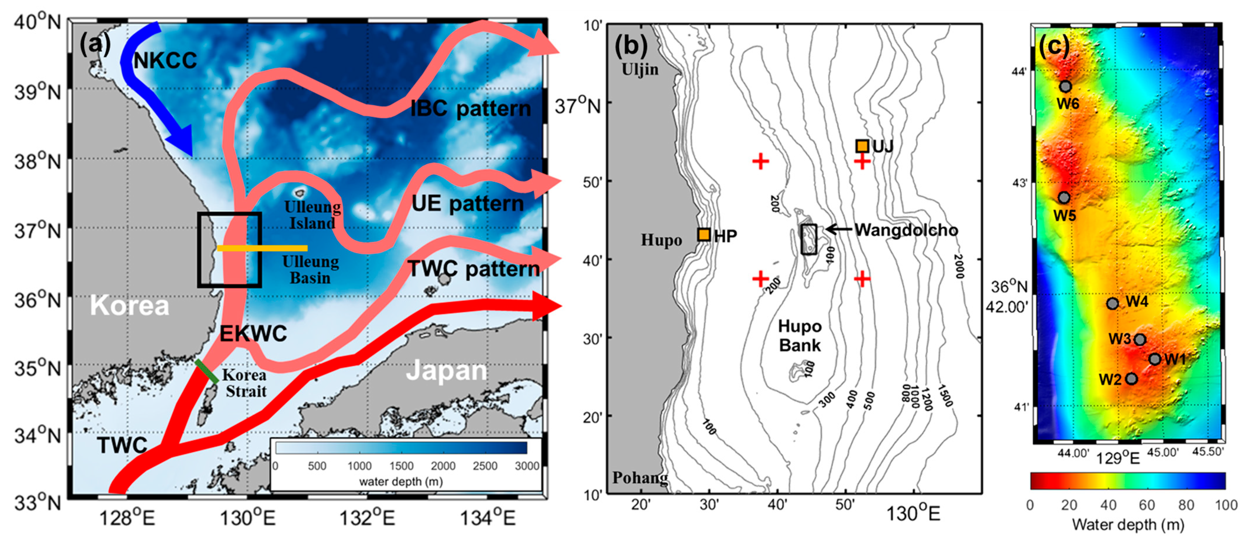
2.1. Moored Current Measurements

Time series data were collected from a total of six bottom-mounted moorings situated near the Wangdolcho Reef (Figure 1c). Since June 2021, the mooring W1 has been equipped with Nortek’s Acoustic Wave and Current profiler (AWAC) at a depth of 20 m. A similar dataset was collected for the moored AWACs at depths of 17 and 20 m for moorings W2 and W3, respectively, from June 2021 to March 2022. Since March 2022, Nortek’s SIGNATURE instrument has been moored at depths of 25, 22, and 25 m at W4, W5, and W6, respectively, to collect similar time series data. Details of the moorings are provided in Table 1. The observation included bottom pressure, bottom temperature, and profiles of current speed and direction at 10 min intervals, with a depth bin size of 1 m. Data were collected continuously except for a few maintenance days. To remove high-frequency fluctuations, a low-pass filter was applied to all moored data using a fifth-order Butterworth filter with a 40 h cut-off period, and the data were then bin-averaged over 1 h. As the observed horizontal current, pressure, and temperature were relatively consistent across all six moorings, the focus was mainly on mooring W1 data, which had a longer time coverage. Monthly statistical analysis of the depth-averaged currents was conducted. The August monthly mean was defined as the mean of the data from July 15 to August 15. Principal axis analysis was used to determine the major direction of the current fluctuations after removing the record-length mean current.

2.2. Ancillary Data

To supplement the moored time series data at a horizontally fixed position, daily gridded absolute dynamic topography (ADT) and geostrophic current data ( u g e o and v g e o ), based on satellite altimetry from the Copernicus Marine Environment Monitoring Service (https://marine.copernicus.eu, accessed 17 August 2024) for the period of 1993–2022, were used. The horizontal resolution of gridded data was 0.25°. To compare with the observed currents at Wangdolcho and examine long-term variability, coastal currents off the east coast of Korea were averaged using data from satellite observation grids (red crosses in Figure 1b). In the Wangdolcho area, the alongshore current was defined as the meridional current, running parallel to the coastline. The alongshore current in the western channel of the Korea Strait, which serves as the input to the EKWC, was defined as the average current from the green line in Figure 1a, oriented at 45° clockwise from north. To identify the offset of the EKWC main axis from the coast, the longitude index was defined as the longitude at which the geostrophic current reached its maximum at 37.25° N. Spatiotemporal variations of SST were analyzed using the realistic remote-sensed sea surface temperature data from the Remote Sensing System (REMSS; www.remss.com, accessed on 17 August 2024). The REMSS Optimum Interpolation SST is a merged product created by combining SST data obtained using infrared and microwave sensors to fill all gaps. The SST was sampled daily with a spatial resolution of 9 km. To examine wind stress on the sea surface, the hourly 10 m wind data from ECMWF Reanalysis v5 (ERA5) [30], provided by the European Centre for Medium-Range Weather Forecast (https://www.ecmwf.int/en/forecasts/dataset/ecmwf-reanalysis-v5, accessed on 17 August 2024) were used. To align with the time intervals, the hourly wind data were averaged over daily intervals.
Observed wind and SST data were obtained from the Uljin (UJ) and Hupo (HP) ocean observation buoys, which are closest to Wangdolcho (orange squares in Figure 1b), provided by the Korea Meteorological Administration (https://data.kma.go.kr/cmmn/main.do, accessed on 17 August 2024). The UJ and HP buoys are considered to be representative of offshore and coastal conditions, respectively. The wind data, acquired at 2 m above the sea surface, were converted to 10 m winds ( W 10 ), assuming a logarithmic profile. Wind stress was calculated from the buoy wind and ERA5 data using τ = ρ a i r C D W 10 W 10 , where the air density ( ρ a i r ) and drag coefficient ( C D ) were set to 1.225 kg/m−3 and 0.00125, respectively.

3. Results and Discussions

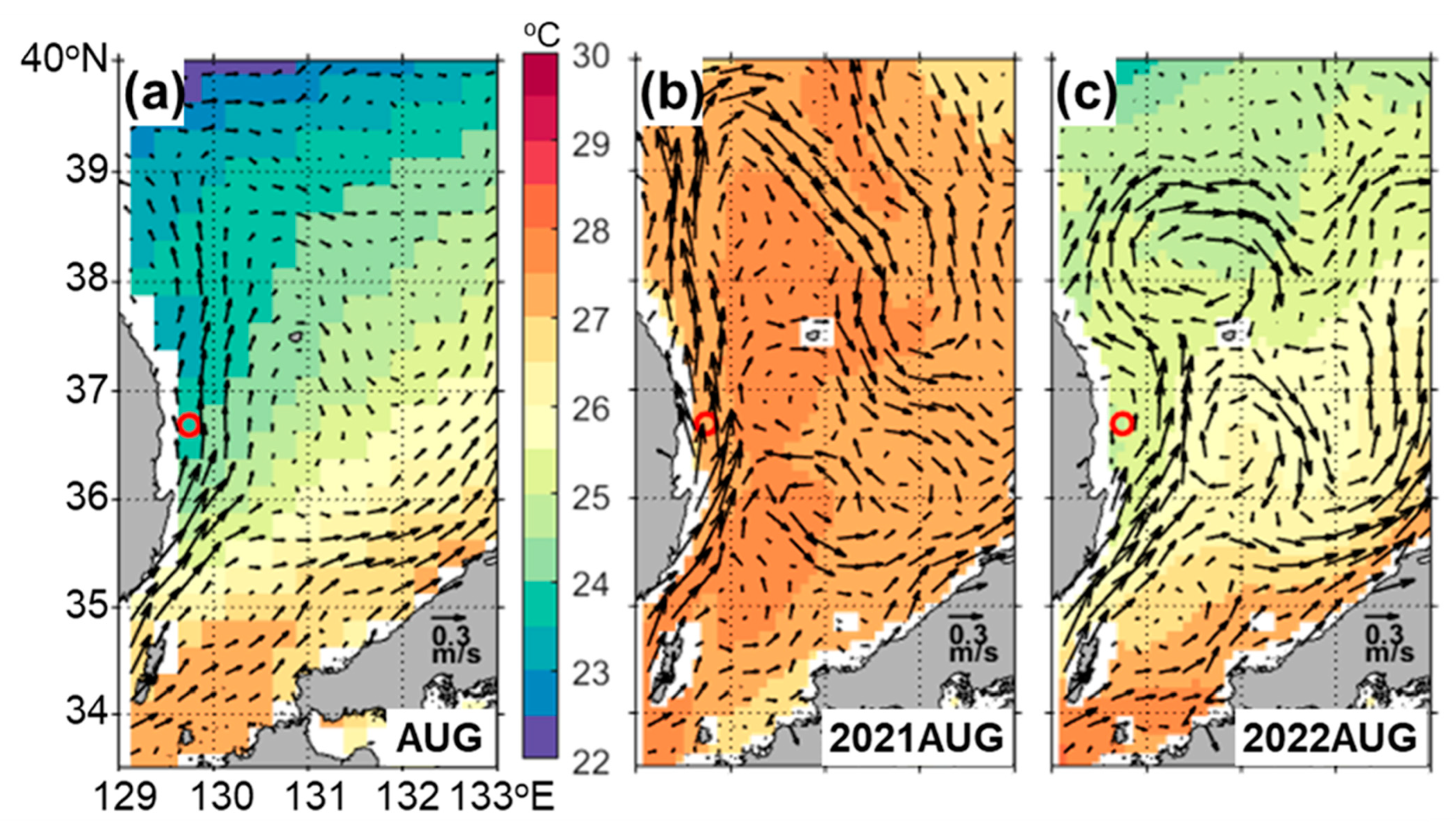
3.1. Observations of the Current off East Coast of Korea

Currents observed from the six moorings off the east coast of Korea revealed considerable variability, with a predominantly northward flow (Figure 2). The depth-averaged zonal ( U ) and meridional ( V ) components showed nearly identical mean velocities across the six moorings, except during May and June 2022. The U had a mean velocity of 0.06 m/s and a standard deviation of 0.29 m/s, whereas the V showed a higher mean velocity of 0.48 m/s and a standard deviation of 0.37 m/s. This indicates that the variability in this region is predominantly driven by the V , as its standard deviation was close to the mean velocity compared to that of the U . The major current in all six moorings were primarily northward, irrespective of the observation period.
We analyzed the statistical characteristics of W1, which had the longest observation period, to examine the temporal variability of horizontal currents in this coastal area (Table 2). The V was generally greater than U throughout the observation period, with a northward flow except from August to September 2022 (negative V indicating southward flow) (see also Figure 2b). The mean kinetic energy (MKE) was 0.01–0.23 m2/s2, peaking in August 2021 and reaching its lowest value in August 2022. The eddy kinetic energy (EKE) ranged from 0.01 to 0.06 m2/s2, with the highest value recorded in December 2021 and the lowest in June 2021. The MKE was generally high during spring and summer, whereas the EKE peaked during winter. Principal axis analysis shows the major direction of current fluctuations. From June to September 2021, these fluctuations predominantly occurred in a northwest direction (126°–157°). From September 2021 to April 2022, the major direction shifted to the east (3°–25°). Between May and July 2022, fluctuations were again predominantly northwest (101°–143°), whereas from June 2022 onwards, the major direction changed to the northeast (16°–41°). The currents were generally directionally stable throughout the period, except for the summer of 2022. Given that the EKWC is the predominant current in the Wangdolcho area, the observed dominant northward flow in the study area may be influenced by it.
The observed current at W1 showed significant seasonal variations (Figure 2 and Table 2). Peaks in V were observed in August and November 2021 (Figure 2b). This pattern is slightly consistent with previous research indicating that the TWC entering through the western channel of the Korea Strait increases around February to March, reaching its peak in both August and October [31]. However, this pattern was not captured in 2022, with the V being nearly zero during August. Notably, the V reached its highest monthly depth-averaged velocity of 0.81 m/s in August 2021. In contrast, in August 2022, it dropped to a minimum of −0.05 m/s, indicating a relatively weak southward flow during the summer of 2022. Considering the surface mean current of ~0.50 m/s for the EKWC in summer [11], the observed currents exhibited significantly high variability during that time.

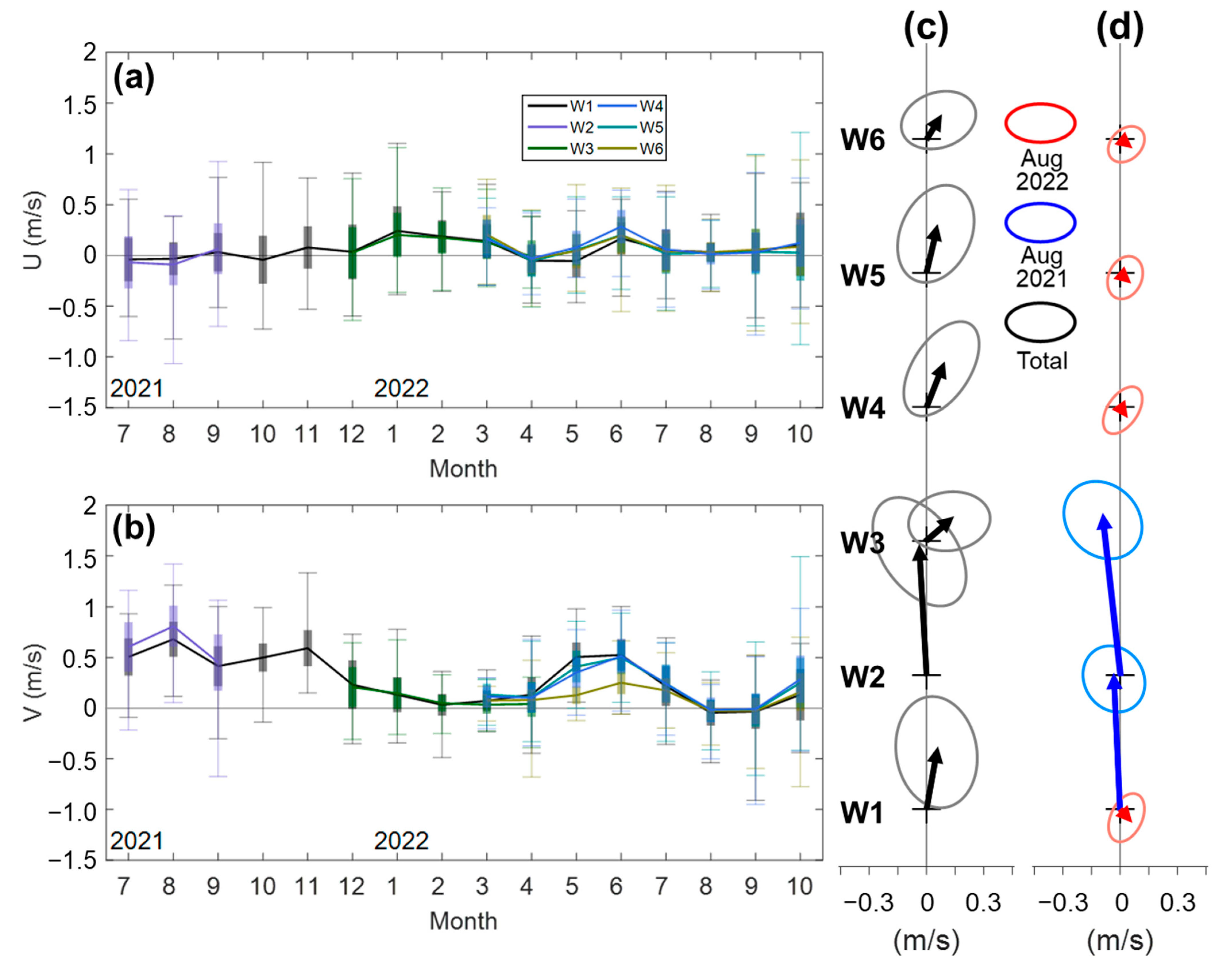
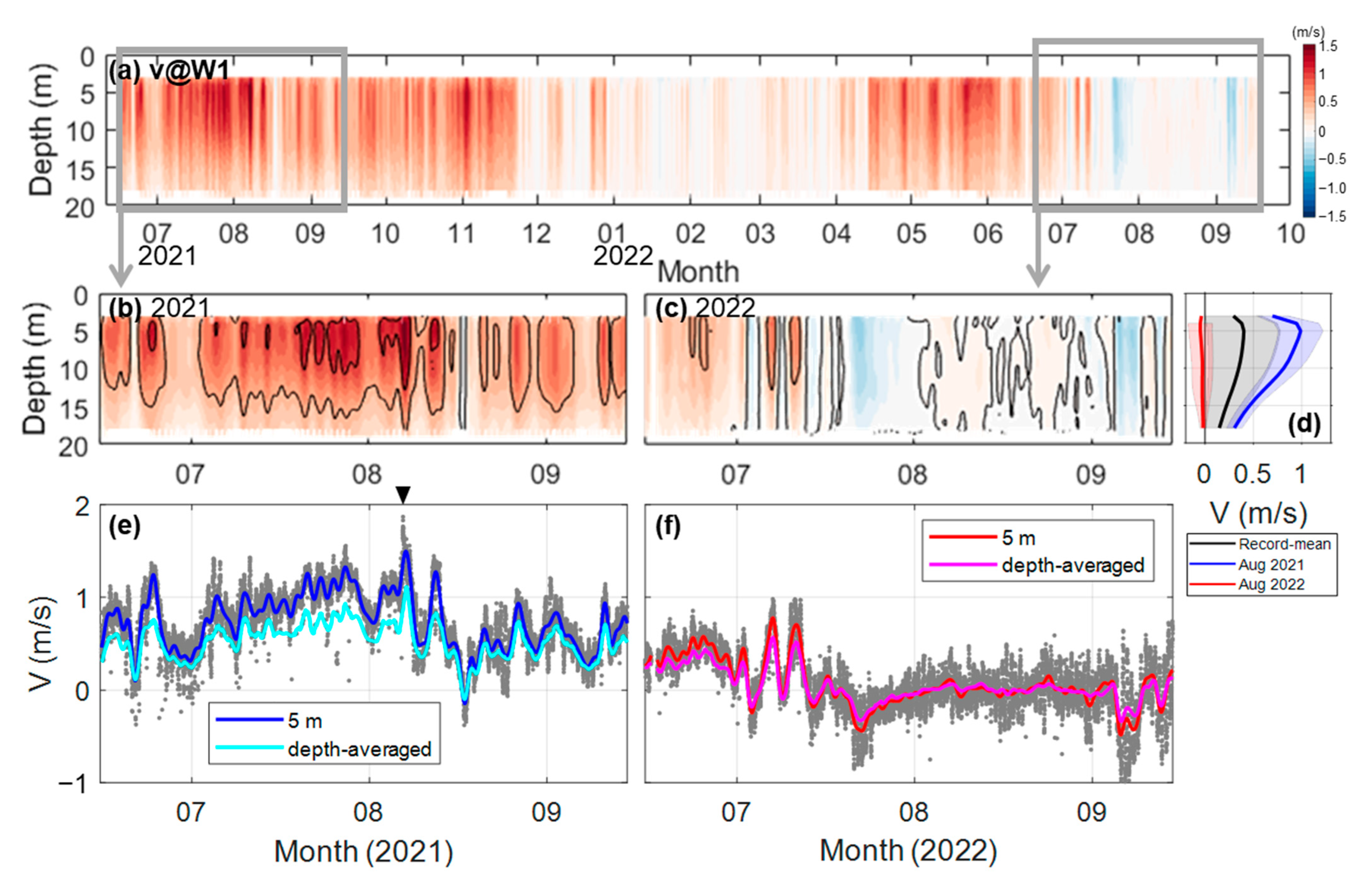
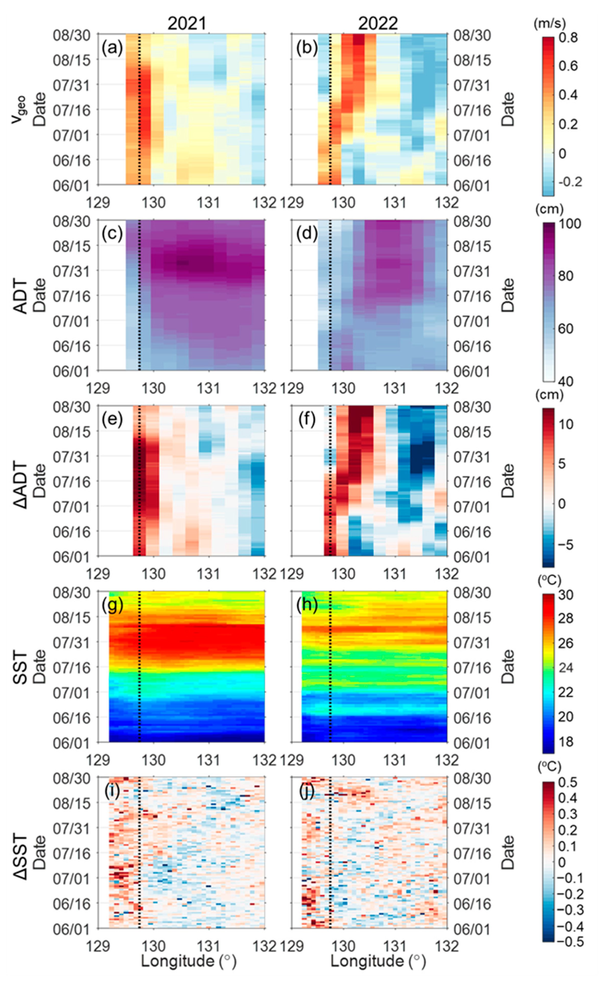
3.2. Comparison of Summer Currents between 2021 and 2022

Summer currents along the eastern coast of Korea in 2021 and 2022 showed significant differences compared to the mean summer current associated with the EKWC, highlighting significant deviations from typical summer patterns. The significant interannual variability was characterized by strongly northward currents in the summer of 2021 and weakly southward currents in the summer of 2022 (Figure 2b and Figure 3). In August 2021, the observed V had a mean velocity of 0.83 m/s northward (91° counterclockwise from the east; blue arrows in Figure 2d), whereas in August 2022, the mean velocity reversed to 0.14 m/s southward (−26°; red arrows in Figure 2d). These currents were consistent with W1 and W2 indicating the same behavior in 2021 and with W1, W4, W5, and W6 in 2022. Detailed observations of the velocity changes for each summer show that in 2021 (Figure 3e), the V significantly intensified from early July, reaching a mean velocity of 1.11 m/s on August 6, with a maximum instantaneous speed of 1.89 m/s at 5 m depth, following which it sharply decreased in mid-August. Conversely, in 2022, the V remained near zero from mid-July to early September (Figure 3f).
The vertical structures of V also support dominant northward flows at all depths except during the summer of 2022 (Figure 3a), with its time-averaged vertical profiles exhibiting significant variability between the summers of 2021 and 2022 (Figure 3b–d). The mean profile ranges from 0.14 to 0.40 m/s (black line in Figure 3d). The averaged V reaches its maximum at a depth of 5 m and weakens with increasing depth. The positive values indicate a predominance of northward currents (black solid line), which was particularly pronounced in August 2021 (blue solid line). In contrast, the vertical profile for 2022 shows negative or near-zero values (red solid line), yielding a different current direction compared to 2021.
Moreover, satellite-based geostrophic currents also exhibited consistent variations with mooring observations. The monthly alongshore geostrophic currents ( v g e o ) in the Wangdolcho area from 1993 to 2022 showed significant seasonal variability (Figure 4). The climatological v g e o in the Wangdolcho area indicates stronger currents in spring (April to June) and autumn (October to November) and weaker in summer (July to September) and winter (December to March), with a double-peak distribution (black line in Figure 4). During 2021, the v g e o exceeded the climatological average for most of the year, except for January and February (blue line in Figure 4). Notably, in August 2021 (green dashed line), the v g e o recorded velocities of 0.50 m/s, which was more than twice the climatological average of 0.22 m/s. In contrast, the v g e o in August 2022 was nearly zero at 0.03 m/s. This supports the consistency of satellite observations with the currents recorded at the moorings in the Wangdolcho area, aligning with the in situ data that show extremely stronger than average currents in August 2021 and clearly weaker currents in 2022.

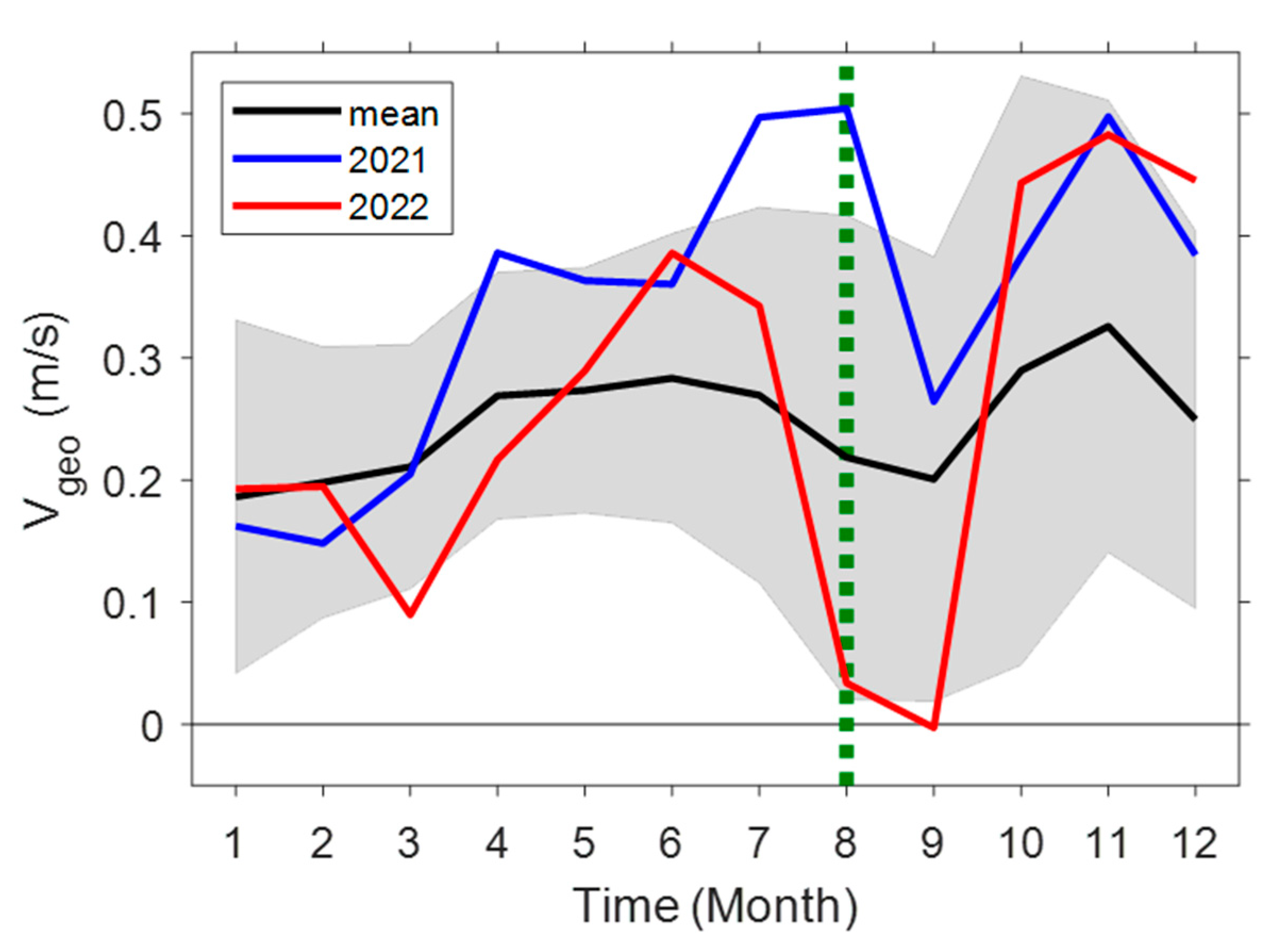
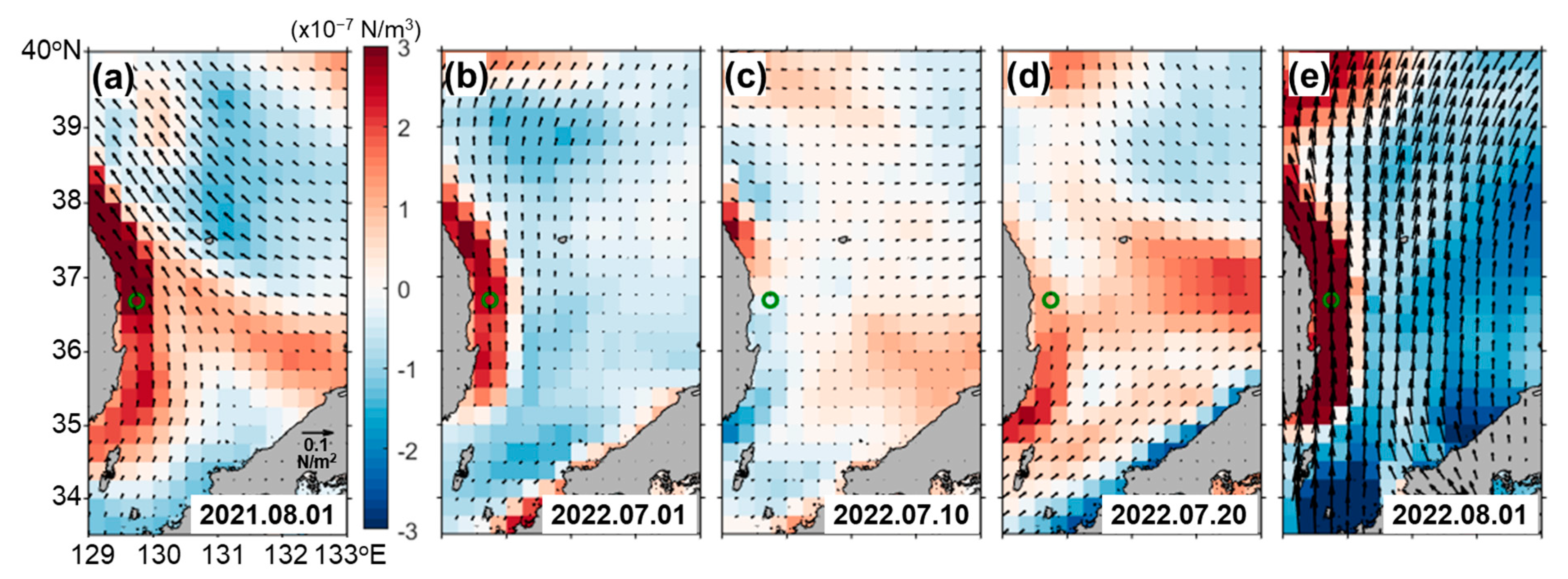
3.3. Environmental Conditions in the Summer of 2021 and 2022

To understand the differing currents during these two periods, we qualitatively examined these velocity changes in relation to the environmental conditions in the summer of 2021 and 2022. The variations in v g e o in the Wangdolcho area were generally consistent with changes in the observed currents, except for high-frequency fluctuations (Figure 5). In the summer of 2021, the observed V increased until August 6, then sharply decreased (black line in Figure 5a). Similarly, the v g e o in 2021 (blue line) gradually increased in July, reached its maximum speed on August 1, and then slowly decreased. In 2022 (black line in Figure 5b), the observed V exhibited two significant fluctuations in early July, then abruptly decreased from July 8 and remained nearly zero until August. Likewise, the v g e o in 2022 (blue line) remained steady in June, rapidly decreased after July 8, and then stayed nearly zero. This suggests that changes in the observed currents during the summer in both years might be related to the variations in geostrophic currents.

3.3.1. EKWC Strengthening and Weakening in 2021

The strengthening and weakening of the EKWC in the summer of 2021 were reported by Pak et al. [29], who suggested that changes in the EKWC’s velocity are more related to local geostrophic currents than to the transport volume through the Korea Strait, with the variations in geostrophic current being associated with warm eddies and typhoons. In this study, we reviewed the environmental conditions in the summer of 2021 with respect to the variations observed in the EKWC.
The intensified current was closely related to rising sea levels and temperatures (Figure 6). During this period, the EJS experienced a region-wide marine heatwave that provided substantial heat energy [32,33] and a locally warm eddy developed between 130° E and 131° E [29], leading to dramatic fluctuations in sea levels and temperatures. The SST began to rise significantly in mid-July 2021, increasing by ~5 °C within 2 weeks and remaining high until 7 August (green line in Figure 5c). Meanwhile, sea bottom temperature (SBT) remained relatively stable at ~16 °C (Figure 5c). From 7 August, the coastal and offshore SST decreased while SBT increased to >25 °C (Figure 5c). In particular, the formation of these local eddies caused significant variations in SST and sea surface height in the offshore regions (Figure 6c,g). The development of mesoscale eddies began in early July (see also Figure 9 in Pak et al. [29]). Compared to the climatological average for August, the spatial SST and geostrophic current for August 2021 clearly shows the development of these eddies (Figure 7a,b). Due to the developed eddy, both ADT and its horizontal differences (∆ADT) increased (Figure 6c,e), resulting in intensified geostrophic currents (Figure 6a). Conversely, following the weakening of the eddies after early August, both ADT and ∆ADT decreased (Figure 6c,e), leading to a weakening in geostrophic currents (Figure 6a). These variations in geostrophic currents due to the development and weakening of the eddy had a notable impact on the intensification and weakening of currents during the summer of 2021.
According to Pak et al. [29], the sharp weakening in current velocities observed after early August is attributed to changes in sea level height along the coast. Despite the overall similarity in trends between the observed currents and geostrophic currents (Figure 5a), the satellite-based geostrophic currents did not detect an abrupt decrease in velocities. This discrepancy is likely due to the coastal issues and resolution limitations of satellite-based data. Hence, the coastal sea level anomaly was linked to coastal upwelling and downwelling induced by alongshore winds [17,29]. Positive alongshore wind stress from late July to early August, linked to upwelling-favorable conditions, led to cooling in SST (Figure 5c). The cooling effect from SST-driven upwelling increased the horizontal density gradient, which enhanced the geostrophic current and, in turn, intensified the EKWC. This contributed to intensified current velocities, with the maximum recorded on August 6 (Figure 5e). Conversely, strong negative wind stress related to typhoons in mid-August led to a decrease in the sea level anomaly, resulting in a sharp weakening of current velocities [29]. The intensification of the EKWC during the summer of 2021 coincided with a robust marine heatwave in the EJS. However, the marine heatwave, which led to increased SST and weakened coastal upwelling, contributed to reduced current intensification. Although the heatwave may have influenced the warm eddy formation, the exact relationship remains unclear [29]. In summary, the observed changes in coastal currents during the summer of 2021 were significantly driven by temporal variability in the EKWC, influenced by variations in SST and sea level caused by warm eddies and typhoons.

3.3.2. EKWC Offshore Shift in 2022

The geostrophic current in the summer of 2022 displayed different patterns compared to 2021. Considering that the EKWC flows into the EJS, its variability can be linked to variations in the volume transport through the Korea Strait (Figure 1a). While the geostrophic currents in the Wangdolcho and Korea Strait showed a similar increasing trend during the summer of 2021 (blue and cyan lines in Figure 5a), those in Wangdolcho sharply decreased in 2022 from mid-July, while those in the Korea Strait continued to increase until early August (Figure 5b). In the summer of 2022, the coastal geostrophic currents increased until 16 July and then decreased (Figure 6b), whereas the offshore geostrophic currents increased from early July to August. This pattern suggests that the EKWC, which initially flowed northward along the coast until mid-July, began to shift offshore beyond 130° E post-July 15, leading to a weakened southward flow in the coast and the Wangdolcho area (Figure 6b).
The offshore shift of the EKWC can be attributed to changes in the overall trajectory of the current (Figure 7). In a typical August, the EKWC entering through the Korea Strait flows along the coast, gradually weakening past ~36° N but continuing its northward trajectory (Figure 7a). In contrast to the strong northward-flowing IBC pattern of the EKWC observed along the coast in August 2021 (Figure 7b), the EKWC in August 2022 exhibited a slightly UE pattern, with its trajectory shifting offshore beyond 130° E (Figure 7c). The EKWC in August 2022 exhibited the UE pattern, marked by a warm eddy developed offshore between 130° and 132° E and 36°–37° N and the EKWC offshore shift past 130° E. The offshore shift of EKWC indicated a reduced local influence on the Wangdolcho area, altering the dynamics observed in this region compared to the previous year.
The offshore shift of the EKWC is closely related to the local negative wind stress curl [16,20] and negative current vorticity in the Korea Strait [10]. The vorticity remained positive throughout the summer of 2021 (Figure 5g). In contrast, in the summer of 2022, it began to decrease from July 16 and turned negative by July 24 (Figure 5h), which aligned with the decrease in coastal currents and the offshore shift of the EKWC. The wind stress curl along the coast was predominantly positive in August 2021 (Figure 8a), which allowed the EKWC to remain close to the coast and flow northward. Conversely, during early July 2022, positive wind stress curl kept the EKWC near the coast (Figure 8b), but a shift to negative wind stress curl by mid-July led to it moving offshore (Figure 8c). Despite a later increase in the positive wind stress curl through August (Figure 8d,e), the EKWC remained offshore. The negative vorticity and positive wind stress curl in early August created compensating conditions, yet the EKWC maintained its offshore position. In summary, while the EKWC was similarly strengthened by wind-stress-induced coastal upwelling in summer 2022 as in 2021, the negative vorticity in the Korea Strait and negative wind stress curl along the coast contributed to the EKWC offshore shift, resulting in near-zero current velocities along the coast.

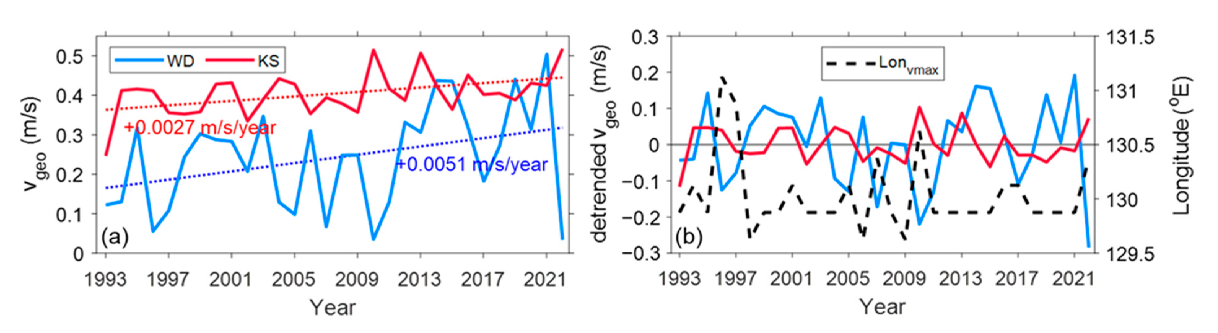
3.4. Long-Term Variability in Summertime Coastal Current

To examine the long-term variability in alongshore currents, geostrophic currents for August from 1993 to 2022 were analyzed (Figure 9). The Wangdolcho area exhibited a significant long-term trend in currents, increasing at a rate of 0.0051 m/s/yr, compared to 0.0027 m/s/yr in the Korea Strait (Figure 9a). Notable inter-annual variability was also observed in both regions. Specifically, in Wangdolcho, the alongshore current reached a maximum of 0.51 m/s in August 2021, while in August 2022, it dropped to a minimum of 0.03 m/s, demonstrating substantial inter-annual fluctuations. A correlation analysis of currents between the Wangdolcho and the Korea Strait revealed a low correlation coefficient of −0.06 (without time-lag), suggesting that while peak currents in the two regions might appear out of phase, the relationship is weak. This discrepancy, particularly in summer 2022, can be attributed to the fact that the EKWC entering the Korea Strait may not always affect the Wangdolcho area, leading to a reduced correlation when the currents do not reach the coastal zone.
The correlation of currents between the Wangdolcho and the Korea Strait does not fully explain their long-term variability observed at Wangdolcho. Instead, the Wangdolcho currents may be closely related to the EKWC pattern, depending on its path type. To investigate this relationship, a comparison was drawn with the EKWC longitude index (Figure 9b). This index reflects the EKWC’s path, where a higher index value suggests a more offshore path of the EKWC, and a lower index value indicates a coastward path at a given latitude. A strong correlation coefficient of −0.70 was observed between the Wangdolcho currents ( v g e o , blue line in Figure 9b) and the longitude index (dashed line in Figure 9b). Specifically, the low index in 2021, associated with the IBC pattern, and the high index in 2022, indicative of the UE pattern, support the observed results in this study. Thus, the variability of coastal currents off the east coast of Korea, such as in the Wangdolcho area, was observed to be influenced by both the intensity and path of the EKWC.
The increasing trends in the EKWC resemble the general long-term intensification and poleward shift of the WBCs [34,35,36]. The WBCs are intensifying and shifting poleward due to global warming, driven by stronger near-surface ocean winds [34]. While specific studies on the EKWC’s long-term trends are limited, recent data show significant warming and stronger winds in the EJS [19,37,38]. To better understand the dynamics of the EKWC and other WBCs, long-term observations are crucial. Continuous and comprehensive monitoring is essential to capture these changes and enhance our understanding of the WBCs and their impact on the marine environment.

4. Concluding Remarks

This study presents observations of coastal currents off the east coast of Korea from June 2021 to October 2022, highlighting both monthly and annual fluctuations. Notably, the depth-averaged velocity of the currents ( V ) peaked at 0.81 m/s in August, which is significantly higher compared to typical currents, and dropped to a minimum of −0.05 m/s in August 2022, indicating a slower flow. This significant inter-annual variability reveals the complex coastal current dynamics, which are influenced by seasonal changes.
The variability in coastal currents during the summers of 2021 and 2022 is closely linked to the changing environmental conditions. In the summer of 2021, the development of mesoscale eddies in the offshore regions contributed to an increase in current velocities, while variations in alongshore wind stress led to upwelling (positive wind stress) and downwelling (negative wind stress) conditions that significantly affected the abrupt intensification and weakening of currents. In the summer of 2022, strong positive alongshore wind stress and upwelling conditions initially identified the EKWC. However, from mid-July, the shift to negative alongshore wind stress curl and negative current vorticity in the Korea Strait caused the EKWC to move offshore, resulting in a weaker southward flow along the coast.
Our findings are limited by the relatively short duration of observations and the challenges in data collection, which constrains the ability to fully capture long-term trends. Addressing these limitations is crucial for a more comprehensive understanding of the coastal current dynamics. Thus, continuously long-term in situ monitoring is essential to further understand these dynamics and their impacts. The upcoming establishment of the Wangdolcho Ocean Research Station as part of the Korea Ocean Research Station [39,40] is anticipated to improve the monitoring capabilities. Long-term continuous observations, coupled with advanced modeling techniques, will be essential for a deeper understanding of coastal currents and their broader environmental impacts.

Author Contributions

Conceptualization, S.-W.L., G.P., J.-H.P. and S.N.; methodology, S.-W.L. and S.N.; formal analysis, S.-W.L.; investigation, S.-C.L.; data curation, S.-W.L.; writing—original draft preparation, S.-W.L., S.N. and G.P.; writing—review and editing, S.-W.L., G.P., J.-H.P., J.-Y.J. and S.N.; visualization, S.-W.L. and S.-C.L.; supervision, J.-Y.J. and S.N.; project administration, J.-Y.J.; and funding acquisition, J.-Y.J. All authors have read and agreed to the published version of the manuscript.

Funding

This research was supported by Korea Institute of Marine Science & Technology Promotion (KIMST) funded by the Ministry of Oceans and Fisheries (20210607, Establishment of the Ocean Research Station in the Jurisdiction Zone and Convergence Research). S.N. was supported by Korea Institute of Marine Science & Technology Promotion (KIMST) funded by the Ministry of Oceans and Fisheries (RS-2022-KS221667, Study on Northwestern Pacific warming and genesis and rapid intensification of typhoon).

Institutional Review Board Statement

Not applicable.

Informed Consent Statement

Not applicable.

Data Availability Statement

The observational data used in this study are available upon request from the corresponding author. The other contributions of this study are included in the article. Further inquiries can be directed to the corresponding authors.

Conflicts of Interest

The authors declare no conflicts of interest.

References

  1. Kelly, K.A.; Caruso, M.J.; Singh, S.; Qiu, B. Observations of atmosphere-ocean coupling in midlatitude western boundary currents. J. Geophys. Res. Oceans 1996, 101, 6295–6312. [Google Scholar] [CrossRef]
  2. Colling, A. Ocean Circulation; Butterworth-Heinemann: Oxford, UK, 2001; Volume 3. [Google Scholar]
  3. Taguchi, B.; Nakamura, H.; Nonaka, M.; Xie, S.P. Influences of the Kuroshio/Oyashio Extensions on air–sea heat exchanges and storm-track activity as revealed in regional atmospheric model simulations for the 2003/04 cold season. J. Clim. 2009, 22, 6536–6560. [Google Scholar] [CrossRef]
  4. Yoon, J.H. Numerical experiment on the circulation in the Japan Sea: Part I. formation of the East Korean Warm Current. J. Ocean. Soc. Jpn. 1982, 38, 43–51. [Google Scholar] [CrossRef]
  5. Katoh, O.; Teshima, K.; Kubota, K.; Tsukiyama, K. Downstream transition of the Tsushima Current west of Kyushu in summer. J. Oceanogr. 1996, 52, 93–108. [Google Scholar] [CrossRef]
  6. Cho, Y.K.; Kim, K. Seasonal variation of the East Korea Warm Current and its relation with the cold water. Mer 1996, 34, 172–182. [Google Scholar]
  7. Shin, H.R.; Shin, C.W.; Kim, C.; Byun, S.K.; Hwang, S.C. Movement and structural variation of warm eddy WE92 for three years in the western East/Japan Sea. Deep. Sea Res. Part II Top. Stud. Oceanogr. 2005, 52, 1742–1762. [Google Scholar] [CrossRef]
  8. Seung, Y.H. A simple model for separation of East Korean Warm Current and formation of North Korean Cold Current. J. Korean Soc. Oceanogr. 1992, 27, 189–196. [Google Scholar]
  9. Cho, Y.K.; Kim, K. Branching mechanism of the Tsushima Current in the Korea Strait. J. Phys. Oceanogr. 2000, 30, 2788–2797. [Google Scholar] [CrossRef]
  10. Lee, D.K.; Niiler, P. Surface circulation in the southwestern Japan/East Sea as observed from drifters and sea surface height. Deep-Sea Res. Part I 2010, 57, 1222–1232. [Google Scholar] [CrossRef]
  11. Chang, K.I.; Teague, W.J.; Lyu, S.J.; Perkins, H.T.; Lee, D.K.; Watts, D.R.; Kim, Y.B.; Mitchell, D.A.; Lee, C.M.; Kim, K.; et al. Circulation and currents in the southwestern East/Japan Sea: Overview and review. Prog. Oceanogr. 2004, 61, 105–156. [Google Scholar] [CrossRef]
  12. Yoon, J.H.; Abe, K.; Ogata, T.; Wakamatsu, Y. The effects of wind-stress curl on the Japan/East Sea circulation. Deep Sea Res. Part II 2005, 52, 1827–1844. [Google Scholar] [CrossRef]
  13. Kim, K.; Legeckis, R. Branching of the Tsushima Current in 1981–1983. Prog. Oceanogr. 1986, 17, 265–276. [Google Scholar] [CrossRef]
  14. Choi, B.J.; Haidvogel, D.B.; Cho, Y.K. Interannual variation of the Polar Front in the Japan/East Sea from summertime hydrography and sea level data. J. Mar. Syst. 2009, 78, 351–362. [Google Scholar] [CrossRef]
  15. Kim, K.; Cho, Y.K.; Choi, B.J.; Kim, Y.G.; Beardsley, R.C. Sea level variability at Ulleung Island in the East (Japan) Sea. J. Geophy. Res. 2002, 107, 3015. [Google Scholar] [CrossRef]
  16. Trusenkova, O.; Nikitin, A.; Lobanov, V. Circulation features in the Japan/East Sea related to statistically obtained wind patterns in the warm season. J. Mar. Syst. 2009, 78, 214–225. [Google Scholar] [CrossRef]
  17. Choi, B.J.; Cho, S.H.; Jung, H.S.; Lee, S.H.; Byun, D.S.; Kwon, K. Interannual variation of surface circulation in the Japan/East Sea due to external forcings and intrinsic variability. Ocean Sci. J. 2018, 53, 1–16. [Google Scholar] [CrossRef]
  18. Pak, G.; Kim, Y.H.; Park, Y.G. Lagrangian approach for a new separation index of the East Korea Warm Current. Ocean Sci. J. 2019, 54, 29–38. [Google Scholar] [CrossRef]
  19. Jeong, Y.; Nam, S.; Kwon, J.I.; Uppara, U.; Jo, Y.H. Surface warming slowdown with continued subsurface warming in the East Sea (Japan Sea) over recent decades (2000–2014). Front. Mar. Sci. 2022, 9, 825368. [Google Scholar] [CrossRef]
  20. Park, J.-H.; Nam, S. Causes of interannual variation of summer mean alongshore current near the east coast of Korea derived from 16-year-long observational data. J. Geophys. Res.: Oceans 2018, 123, 7781–7794. [Google Scholar] [CrossRef]
  21. Mitchell, D.A.; Watts, D.R.; Wimbush, M.; Teague, W.J.; Tracey, K.L.; Book, J.W.; Chang, K.I.; Suk, M.S.; Yoon, J.H.; Suk, M.S.; et al. Upper circulation patterns in the Ulleung Basin. Deep Sea Res. Part II 2005, 52, 1617–1638. [Google Scholar] [CrossRef]
  22. Lee, D.K.; Niiler, P.P. The energetic surface circulation patterns of the Japan/East Sea. Deep Sea Res. Part II 2005, 52, 1547–1563. [Google Scholar] [CrossRef]
  23. Shim, J.M.; Jin, H.G.; Sung, K.T.; Hwang, J.D.; Yun, S.H.; Lee, Y.H.; Kim, Y.S.; Kwon, K.Y. The community structure of phytoplankton in winter and summer around Wangdol-cho. J. Environ. Sci. Int. 2008, 17, 1403–1411. [Google Scholar] [CrossRef]
  24. Kim, S.H. Winter occurrence pattern of Chionoecetes opilio around Wangdol Reef in the East Sea near Uljin. Korean J. Fish. Aquat. Sci. 2010, 43, 670–678. [Google Scholar] [CrossRef]
  25. Kwon, C.J.; Choi, C.G. Marine algal flora and community structure in subtidal zone of Wangdol-cho on the east coast of Korea. Sea J. Korean Soc. Oceanogr. 2014, 19, 191–201. [Google Scholar] [CrossRef]
  26. Lee, J.C. Water mass distribution and currents in the vicinity of the Hupo Bank in summer 2010. Korean J. Fish. Aquat. Sci. 2016, 49, 61–73. [Google Scholar] [CrossRef]
  27. Hwang, J.D.; Lee, Y.H.; Shim, J.M.; Young, S.H.; Jin, H.G.; Kim, Y.S.; Kwon, K.Y.; Yoon, S.C.; Yoon, S.C. Physical oceanographic characteristics in Hupo coastal area during summer and autumn, 2007. Korean J. Fish. Aquat. Sci. 2008, 41, 505–510. [Google Scholar] [CrossRef]
  28. Lee, J.C.; Chang, K.I. Variability of the coastal current off Uljin in summer 2006. Ocean Polar Res. 2014, 36, 165–177. [Google Scholar] [CrossRef]
  29. Pak, G.; Lee, K.J.; Lee, S.W.; Jin, H.; Park, J.H. Quantification of the extremely intensified East Korea Warm Current in the summer of 2021: Offshore and coastal variabilities. Front. Mar. Sci. 2023, 10, 1252302. [Google Scholar] [CrossRef]
  30. Hersbach, H.; Bell, B.; Berrisford, P.; Hirahara, S.; Horanyi, A.; Munoz-Sabater, J.; Nicolas, J.; Peubey, C.; Radu, R.; Schepers, D.; et al. The ERA5 global reanalysis. Q. J. R. Meteorol. Soc. 2020, 146, 1999–2049. [Google Scholar] [CrossRef]
  31. Shin, H.R.; Lee, J.H.; Kim, C.H.; Yoon, J.H.; Hirose, N.; Takikawa, T.; Cho, K. Long-term variation in volume transport of the Tsushima warm current estimated from ADCP current measurement and sea level differences in the Korea/Tsushima Strait. J. Mar. Syst. 2022, 232, 103750. [Google Scholar] [CrossRef]
  32. Kuroda, H.; Setou, T. Extensive marine heatwaves at the sea surface in the northwestern Pacific Ocean in summer 2021. Remote Sens. 2021, 13, 3989. [Google Scholar] [CrossRef]
  33. Pak, G.; Noh, J.; Park, Y.G.; Jin, H.; Park, J.H. Governing factors of the record-breaking marine heatwave over the mid-latitude western North Pacific in the summer of 2021. Front. Mar. Sci. 2022, 9, 946767. [Google Scholar] [CrossRef]
  34. Yang, H.; Lohmann, G.; Wei, W.; Dima, M.; Ionita, M.; Liu, J. Intensification and poleward shift of subtropical western boundary currents in a warming climate. JGR Ocean. 2016, 121, 4928–4945. [Google Scholar] [CrossRef]
  35. Chen, C.; Wang, G.; Xie, S.P.; Liu, W. Why does global warming weaken the Gulf Stream but intensify the Kuroshio? J. Clim. 2019, 32, 7437–7451. [Google Scholar] [CrossRef]
  36. Wang, Y.L.; Wu, C.R. Enhanced warming and intensification of the Kuroshio Extension, 1999–2013. Remote Sens. 2019, 11, 101. [Google Scholar] [CrossRef]
  37. Na, H.; Kim, K.Y.; Chang, K.I.; Park, J.J.; Kim, K.; Minobe, S. Decadal variability of the upper ocean heat content in the East/Japan Sea and its possible relationship to northwestern Pacific variability. J. Geophys. Res. Ocean. 2012, 117, C02017. [Google Scholar] [CrossRef]
  38. Lee, E.Y.; Park, K.A. Change in the recent warming trend of sea surface temperature in the East Sea (Sea of Japan) over decades (1982–2018). Remote Sens. 2019, 11, 2613. [Google Scholar] [CrossRef]
  39. Ha, K.-J.; Nam, S.; Jeong, J.-Y.; Moon, I.-J.; Lee, M.; Yun, J.; Jang, C.J.; Kim, Y.S.; Byun, D.-S.; Heo, K.-Y.; et al. Observations utilizing Korea ocean research stations and their applications for process studies. Bull. Am. Meteorol. Soc. 2019, 100, 2061–2075. [Google Scholar] [CrossRef]
  40. Byun, D.-S.; Jeong, J.-Y.; Kim, D.-J.; Hong, S.; Lee, K.-T.; Lee, K. Ocean and atmospheric observations at the remote Ieodo ocean research station in the northern East China Sea. Front. Mar. Sci. 2021, 8, 618500. [Google Scholar] [CrossRef]
Figure 1. (a) Study area (black box) and bathymetry (color shading) along with the schematic current paths of the Tsushima Warm Current (TWC; denser red), East Korea Warm Current (EKWC; lighter red), and North Korea Cold Current (NKCC; blue) off the east coast of Korea, as well as the three EKWC patterns (modified from Lee and Niiler, [10]) of the Inertial Boundary Current (IBC) pattern, Ulleung Eddy (UE) pattern, and Tsushima Warm Current (TWC) pattern. (b) Enlarged map of the black box in (a) showing the location of the Hupo Bank, the gridded data used from CMEMS (red cross), the ocean observation buoy stations (orange squares) named Uljin (UJ) and Hupo (HP), with the bathymetry shown in the background contour lines. (c) Enlarged map of the black box in (b) showing the location of Wangdolcho and the positions of current observations W1–W6 (gray circles), with the bathymetry in the background.
Jmse 12 01512 g001
Figure 2. Monthly mean of the depth-averaged (a) U and (b) V current indicating the standard deviation (box), maximum (top bar), and minimum (bottom bar) values. (c) Record-length (black arrows) and (d) August monthly (blue and red arrows) mean current vectors with their principal axis ellipses. Principal axis ellipses, plotted at the tips of the mean vectors, specify the standard deviations of the fluctuating components in the direction of the principal major and minor axes.
Jmse 12 01512 g002
Figure 3. Time–depth plot of V at mooring W1 during (a) the entire recording period, (b) August 2021, and (c) August 2022. (d) Profiles of mean velocity (solid lines) and standard deviation (shaded) of the alongshore current for the entire recording period (black), August 2021 (blue), and August 2022 (red). (e,f) Time series of V at 5 m depth for the same periods in (b,c). Gray markers indicate 10 min intervals, and the 40 h low-pass filtered current is shown with a blue line for 2021 and a red line for 2022, along with the depth-averaged current (cyan line for 2021 and magenta line for 2022).
Jmse 12 01512 g003
Figure 4. Climatological (1993–2022) monthly mean and associated standard deviation (shaded) of the alongshore geostrophic current (black line) from satellites near Wangdolcho. The alongshore geostrophic current in 2021 and 2022 is denoted by blue and red lines, respectively, and the dotted green line indicates the month of August.
Jmse 12 01512 g004
Figure 5. Time series of (a,b) observed current (gray and black lines) and satellite-based geostrophic current (colored lines), (c,d) sea bottom temperature (SBT; black) and sea surface temperature (SST; green), (e,f) wind stress, and (g,h) relative vorticity for Ugeo@KS during the summer of 2021 and 2022. The yellow and red shadings represent upwelling- and downwelling-favorable conditions, respectively. Ugeo@WD and Ugeo@KS denote the geostrophic currents at the Wangdolcho (WD) and the Korea Strait (KS), respectively. SBT@WD represents the SBT at WD, while SST@UJ and SST@HP refer to the SST at the Uljin (UJ) buoy and Hupo (HP) buoy, respectively.
Jmse 12 01512 g005
Figure 6. Hovmöller diagram as a function of the longitude and time of (a,b) v g e o , (c,d) ADT, (e,f) ∆ADT, (g,h) SST, and (i,j) ∆SST in the summer of 2021 and 2022, respectively. The dotted black line denotes the location of Wangdolcho.
Jmse 12 01512 g006
Figure 7. Horizontal maps of SST and geostrophic currents (black vectors) (a) for the August climatological mean from 1993 to 2022, (b) in August 2021, and (c) in August 2022. Wangdolcho is encircled in red.
Jmse 12 01512 g007
Figure 8. (ae) Horizontal maps of wind stress curl (color shading) and wind stress (black vectors). Wangdolcho is encircled in green.
Jmse 12 01512 g008
Figure 9. Time series of (a) August monthly mean alongshore geostrophic current and (b) detrended geostrophic current at Wangdolcho (WD) and western channel of Korea Strait (KS) with long-term trends (dashed lines). Locations of maximum current at latitude of Wangdolcho are indicated by dashed black line.
Jmse 12 01512 g009
Table 1. Details of the moorings used in this investigation.
MooringLocationDepthStart TimeEnd timeBin SizeSampling
Interval
Frequency
W136°41′24.70″ N
129°44′54.78″ E
20 m15 June 202119 September 20221 m10 min600 kHz
W236°41′14.3″ N
129°44′39.0″ E
17 m24 June20216 September 20211 m10 min1 MHz
W336°41′35.23″ N
129°44′44.88″ E
20 m16 November 202129 March 20221 m10 min600 kHz
W436°41′54.65″ N
129°44′26.78″ E
25 m9 March 202212 October 20221 m10 min500 kHz
W536°42′51.72″ N
129°43′54.87″ E
22 m9 March 202212 October 20221 m10 min500 kHz
W636°43′51.28″ N
129°43′56.38″ E
25 m9 March 202210 October20221 m10 min500 kHz
Table 2. Basic statistics for the depth-averaged currents at 24 h intervals (W1 mooring). STD, MKE, and EKE denote standard deviation, mean kinetic energy, and eddy kinetic energy, respectively. All directions were measured counterclockwise from the east. Direction stability is defined as the ratio between the mean vector and scalar speeds.
W1
Moorings
20212022
Jun.Jul.Aug.Sep.Oct.Nov.Dec.Jan.Feb.Mar.Apr.MayJun.Jul.Aug.Sep.
Mean
( m / s )
U−0.07−0.04−0.030.02−0.040.090.030.250.190.14−0.05−0.060.180.050.030.04
V0.380.600.810.450.500.590.220.130.040.080.150.500.520.21−0.05−0.03
STD
( m / s )
U0.110.210.170.190.230.210.300.230.160.170.150.160.140.210.090.19
V0.090.180.170.200.140.170.230.170.110.100.190.140.160.200.120.18
Max.
( m / s )
U0.090.510.400.740.880.700.781.030.590.630.360.390.540.610.280.78
V0.530.891.200.920.981.260.710.700.320.350.680.920.980.660.260.50
Min.
( m / s )
U−0.22−0.58−0.81−0.50−0.68−0.51−0.55−0.24−0.31−0.26−0.45−0.43−0.39−0.41−0.30−0.59
V0.220.010.17−0.25−0.130.17−0.31−0.31−0.23−0.21−0.410.110.13−0.31−0.51−0.76
Vector meanSpeed
( m / s )
0.400.660.830.460.560.630.380.340.240.220.250.530.570.320.140.21
Dir.
( ° )
979291859385562452567947048−26−10
Max.
( m / s )
0.570.931.220.941.081.280.811.090.610.630.680.920.980.730.530.83
MKE
( m 2 / s 2 )
0.080.130.230.090.130.180.030.040.020.010.010.130.150.020.010.01
EKE
( m 2 / s 2 )
0.010.040.030.040.040.040.060.040.020.020.030.020.020.040.010.03
EKE/MKE 0.120.290.130.410.290.202.581.031.051.542.230.190.151.826.7531.41
Principal
axis ( ° )
1401571261313222522514104143101416516
Direction
stability
0.980.930.970.900.910.950.590.850.790.730.650.950.970.660.430.22
Disclaimer/Publisher’s Note: The statements, opinions and data contained in all publications are solely those of the individual author(s) and contributor(s) and not of MDPI and/or the editor(s). MDPI and/or the editor(s) disclaim responsibility for any injury to people or property resulting from any ideas, methods, instructions or products referred to in the content.

