Review

Review of Research Progress on the Influence of Groundwater Discharge on Seabed Stability

1
Institute of Environmental Science and Engineering, Ocean University of China, Qingdao 266100, China
2
Shandong Provincial Key Laboratory of Marine Environment and Geological Engineering, Ocean University of China, Qingdao 266100, China
*
Authors to whom correspondence should be addressed.
J. Mar. Sci. Eng. 2025, 13(3), 560; https://doi.org/10.3390/jmse13030560
Submission received: 8 January 2025 / Revised: 7 March 2025 / Accepted: 11 March 2025 / Published: 13 March 2025
(This article belongs to the Special Issue Marine Geohazards: Characterization to Prediction)

Abstract

:
Submarine groundwater discharge (SGD) refers to the flow of groundwater that enters seawater through the seabed surface at the edge of the coastal shelf. During this discharge process, seepage and initiation can easily trigger seabed instability, which significantly influences the breeding, occurrence, and evolution of marine geological events. The narrow distribution of land near the coastline and the substantial flux of groundwater discharge are closely associated with typical seabed geological events, such as submarine landslides and collapse pits, which are prevalent in the sea area. This paper analyzes the current research status of SGD both domestically and internationally, elucidates the interaction mechanisms between groundwater discharge and the seabed, and integrates existing studies on discharge-induced slope instability, collapse pit formation, and seabed erosion and resuspension. It summarizes and evaluates the existing research on the influence of seabed groundwater discharge on the evolution of seabed geological structures, identifies key scientific problems that urgently need to be addressed, and proposes future research directions that require further emphasis. Additionally, the paper conducts research on the mechanisms by which groundwater discharge affects seabed stability, providing valuable insights for the study of coastal zones in China. It also offers a scientific basis for enhancing the understanding of the generation mechanisms of marine geological events and improving the technological capabilities for their prevention and control.

1. Introduction

Submarine groundwater discharge (SGD) is an important process of interaction between seawater and terrestrial groundwater in the nearshore area [1]. SGD was first identified in the form of submarine cold seeps in the 1880s [2]. Since the 1980s, SGD, as a new discipline known as marine hydrogeology, has gradually gained recognition. Initially, scholars defined SGD as a groundwater exchange process characterized by diverse directions and properties, encompassing both groundwater flow from the coast into the ocean and seawater intrusion toward the coast [3]. As research has advanced, some scholars have noted that this definition lacks a description of recirculated seawater. Currently, the more comprehensive definition of the SGD system encompasses all water flows entering the benthic boundary layer from the seafloor surface, regardless of the flow components and driving forces [4]. The SGD process involves significant transport and exchange of terrigenous materials, nutrients, heavy metals, and other substances into the ocean. Investigating the characteristics of submarine geomorphological evolution under long-term stable SGD through geophysical exploration methods, such as single-channel seismic, multi-channel seismic, and multibeam bathymetric surveys, holds profound significance [5,6].
SGD is present in nearly all coastal zones, except for polar regions. On a global scale, the flux of SGD is estimated to be three to four times greater than the discharge from rivers into the sea [7]. The high volume and rate of SGD not only contribute to the global water cycle but also transport significant amounts of materials into the ocean. This process plays a vital role in the geochemical cycles of various marine biogenic elements (such as carbon, nitrogen, phosphorus, and silicon) and heavy metals (including lead, cadmium, copper, and zinc), establishing SGD as a critical source supporting aquatic food webs [8,9,10]. With the intensification of human activities, pollutants in groundwater—such as heavy metals, pesticides, and other organic contaminants—are increasingly entering the ocean through SGD. This can alter seawater chemistry, exacerbate ocean acidification, eutrophication, harmful algal blooms, and hypoxia, posing significant threats to the growth and survival of aquatic organisms and impacting coastal marine ecosystems. Additionally, substantial SGD can influence seabed stability. Since the retrospective study of a massive submarine landslide triggered by heavy rainfall in the Var Delta, France, in 1979, the issue of SGD-induced seabed instability has garnered considerable attention from researchers [11]. Numerous scholars have carried out joint research on seabed geology and fluid seepage (both gas and liquid) in areas like the Mediterranean coast, New Zealand, Rhode Island, the Bohai Sea, and the South China Sea [12,13,14,15,16,17,18,19]. These studies have demonstrated that long-term and stable seepage can modify the internal structure and stress state of the seabed, resulting in the destabilization of highly permeable seabed sediments. In regions with steep slopes, this situation is more prone to trigger sediment instability, giving rise to submarine hazards such as submarine landslides, collapse pockmarks, seabed erosion, and resuspension. The influence of SGD on the morphological evolution of seabed topography is incalculable.
This paper employs the literature review approach. It searches multiple databases, such as Web of Science and Scopus, using keywords like “SGD (Submarine Groundwater Discharge)” and “Submarine Seepage” to screen relevant research literature from both domestic and international sources. Through categorizing these studies, the paper summarizes the current research status of SGD at home and abroad, elaborates on the interaction mechanism between groundwater discharge and the seabed, and sums up the theories regarding the impact of SGD on seabed stability via methods such as geophysical exploration, indoor simulation experiments, and numerical model calculations. Subsequently, by integrating existing typical research cases, the paper discusses the influence of the groundwater discharge process on geological events like submarine slope instability and failure, the formation of collapse pockmarks, erosion, and resuspension. Finally, the paper forecasts the key research directions that need to be addressed in the future. The purpose of this review is to analyze and summarize the existing research methods and theories concerning the impact of SGD on the evolution of submarine geological structures, put forward the key issues that urgently need to be resolved, provide certain scientific value for the research on China’s coastal zones in this regard, and offer a reference for enhancing the technical level of marine geological events prevention and control as well as understanding the formation mechanism of the event chain.

2. The Current Status of Research on SGD

Since Moore’s 1996 publication in Nature on the use of Radium (Ra) isotopes to assess SGD [20], research papers with the theme of “Submarine groundwater discharge” have become a hot topic. To date, SGD-related studies have been conducted in most continental shelf margins worldwide, excluding the polar regions (Figure 1).
The SGD process involves the transport and exchange of a large amount of nutrients, metal elements, and other inorganic salts. Countries such as the United States, Japan, and several European nations have conducted extensive research on SGD. Taking the U.S. coastal zone as an example, the SGD at Kāne‘ohe Bay, Hawaii, transports nitrogen and phosphorus nutrients at rates five and two times higher than riverine input, respectively [21]. Along the southeastern coast of North America, the concentration of barium transported to the seawater via submarine fresh groundwater discharge is more than four times the riverine input [22]. The rate of Dissolved Organic Carbon (DOC) input via SGD along the west coast of Florida is 19–27 mmol/(m2·d) [23]. Additionally, other coastal areas where SGD research has been conducted include Sarasota Bay, San Francisco Bay, and Wachua Bay [24,25,26]. In recent years, large-scale SGD research has also been carried out on the Mediterranean coast of Europe, Jeju Island in South Korea, and Toyama Bay in Japan [27,28,29,30,31,32,33] (Table 1).
China has a coastline that stretches for 1.8 × 10⁴ km, making it one of the countries with the longest coastlines in the world [41]. However, research on SGD in China started late and has lagged far behind developed countries such as the United States and Japan. In recent years, however, the research has been developing rapidly. Currently, SGD studies have been conducted at the bay scale in areas such as the Bohai Sea, Laizhou Bay, Xiangshan Bay, Jiaozhou Bay, and Sanasha Bay. Ma et al. [42] estimated the total SGD flux of the muddy beach on the east coast of Laizhou Bay to be 8.8 m3/(m·d) using the generalized Darcy’s law. Wang et al. [43] assessed the SGD in Laizhou Bay, which is about eight times the flow rate of the Yellow River, and estimated the input of terrestrial freshwater to be comparable to the Yellow River’s runoff. Guo Zhanrong et al. [44] used radon (Rn) isotopes to evaluate the SGD rates in Jiaozhou Bay in October 2011 and May 2012, which were 6.38 cm/d and 8.29 cm/d, respectively. SGD studies have also been conducted at the river estuary scale, including the Yellow River Estuary, Yangtze River Estuary, and Pearl River Estuary (Table 2). In the Yellow River Delta, Taniguchi et al. [45] measured the submarine fresh groundwater discharge rate in the southern part of the delta directly using seepage meters and estimated it to be 110–170 m3/s using isotopes. Peterson et al. [46] assessed the SGD to be two to three times the flow rate of the Yellow River. Xu et al. [47,48] used isotopes to evaluate the impact of the Yellow River’s water and sediment regulation period on SGD in the Yellow River Delta. Guo et al. [49] assessed the SGD flux in the Jiulong River estuary area by establishing a mass balance model for 224Ra and 226Ra, which was more than four times the average annual runoff of the Jiulong River. Gu et al. [50] estimated the SGD flux in the Yangtze River plume area based on a 226Ra mass conservation model, which was 6% to 30% of the Yangtze River’s runoff during the flood season.
In China, SGD research has mainly focused on the estimation of discharge flux and rates, the transport of materials between land and sea, and environmental impacts. However, there have been few studies on the influence of the seepage process during discharge on seabed instability. As groundwater flows from the seabed to the seabed boundary layer, the Earth’s internal energy is carried and leaked to the seafloor surface, which can be regarded as a potential dynamic force for the formation of submarine geological events [60]. Nevertheless, current research is insufficient in terms of how SGD flux and rates dynamically change under extreme marine conditions such as heavy rain, storm surges, tsunamis, and earthquakes, the mechanisms of seabed geological events breeding and evolutionary processes under the influence of discharge, and the theoretical methods for events risk prevention and control under the coupling conditions of fluid migration and submarine geology. These areas require further improvement and deepening.

3. Literature Review Methodology

This review follows the guidelines for general literature review papers by Snyder [61] and mainly implements the two main stages of the literature review method:
  • Planning the review: Determining the need for this review paper and identifying the research questions.
  • Conducting the review: Selecting original research, data extraction, and reporting of results.
The review utilizes online databases such as Web of Science, Scopus, and the Multidisciplinary Digital Publishing Institute (MDPI), using keywords like SGD (submarine groundwater discharge) and Submarine Seepage to retrieve the relevant research literature from both domestic and international sources. By categorizing these literature, the review summarizes the current research status on SGD and the causes of submarine geomorphology, including calculation methods of SGD (isotope tracers, hydrological models, etc.) and geophysical exploration technologies for exploring the causes of submarine geomorphology (seismic surveying, multibeam bathymetry, sonar, resistivity surveying, etc.). However, there is a lack of in-depth compilation of these technologies when they are combined for research on SGD-shaped submarine geomorphology. This review effectively uses the obtained materials for integrated analysis, which is very important for studying SGD-shaped submarine geomorphology. Therefore, the main research questions are as follows:
  • R.Q.1 What does submarine groundwater discharge (SGD) imply?
  • R.Q.2 How does SGD interact with the seabed?
  • R.Q.3 What are the main seabed geological structures affected by SGD?
  • R.Q.4 What are the future research directions and trends?

4. The Interaction Mechanism Between SGD and Seabed

SGD can be specifically categorized into two types based on its composition: submarine fresh groundwater discharge (SFGD) and recirculated submarine groundwater discharge (RSGD), with each having a different dynamic mechanism [2]. SFGD primarily involves atmospheric precipitation and river infiltration into aquifers, which, under the action of the nearshore hydraulic gradient, is discharged into the ocean through the seafloor. In the process, it carries a large amount of material (including inorganic elements such as carbon and nitrogen, as well as heavy metals) from the nearshore, playing a significant role in material cycling. RSGD mainly refers to the seawater in the seabed boundary layer that, driven by temperature and density gradients, infiltrates into the seabed and is then discharged back to the seabed surface. This process also forms a mixing zone of saline and freshwater on the seabed surface, which has distinct properties from both seawater and freshwater. In addition to temperature and density as drivers of seawater circulation, hydrodynamic conditions in the seabed boundary layer (waves, tides, currents) and submarine hazards (submarine earthquakes, tsunamis) can also alter the intensity of seawater circulation and discharge, thereby affecting seabed stability.

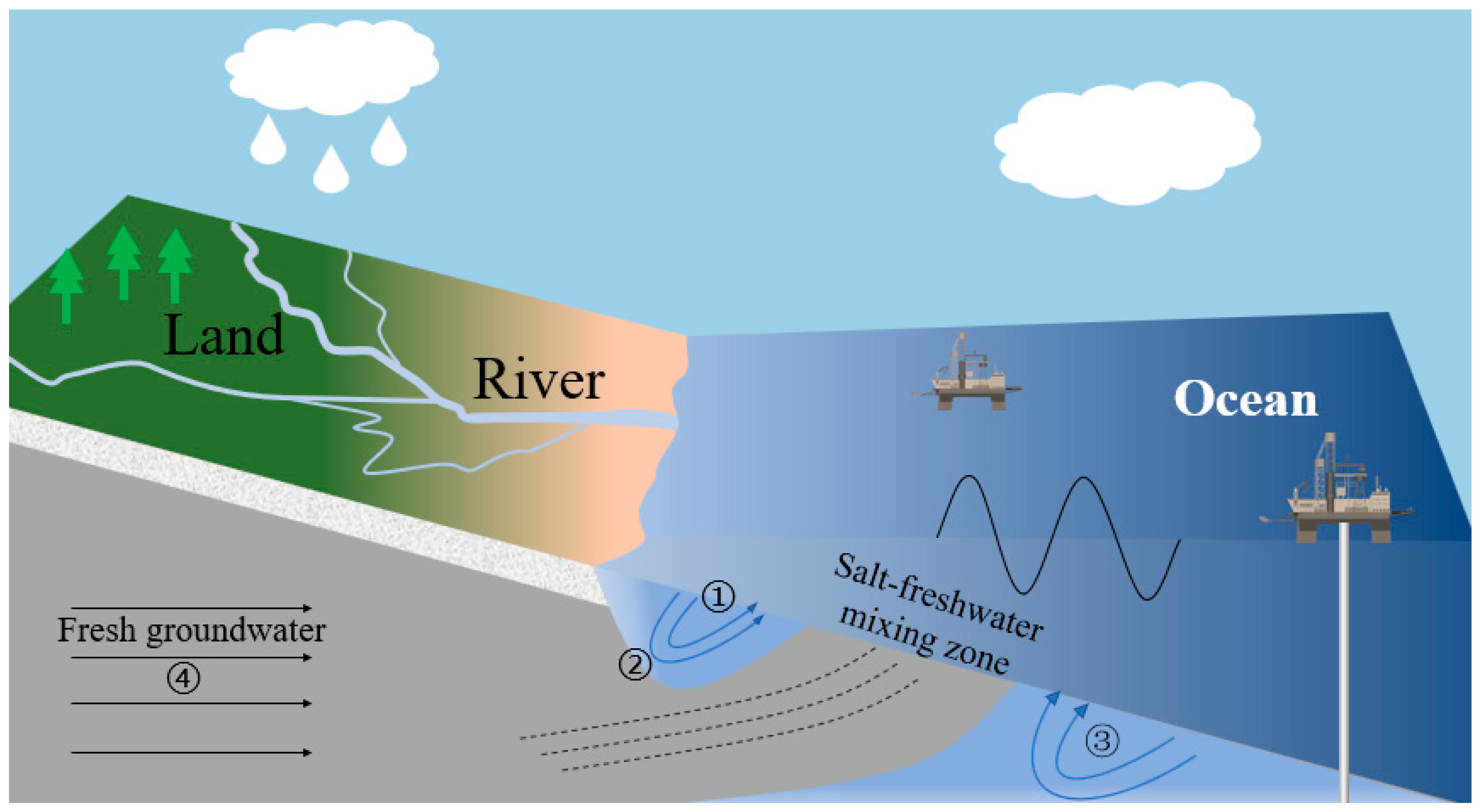
4.1. Regional Geological Conditions Affect SGD

The impact of SGD varies in different geological regions, mainly owing to three factors: sediment permeability, the presence of faults and fractures, and the structure of sedimentary layers. The types of seafloor sediments differ across various marine areas, resulting in significant differences in permeability. For instance, sandstone and limestone have higher permeability, which facilitates the flow and discharge of groundwater, thereby promoting SGD. In contrast, shales and mudstones have lower permeability, which may impede groundwater discharge and affect the rate and distribution of SGD. Seafloor sediments with faults and fractures provide preferential pathways for groundwater flow, enabling faster movement of groundwater and increasing local SGD discharge. The structure and thickness of sedimentary layers also influence the flow paths and discharge rates of groundwater. Thicker sedimentary layers may store more groundwater but have slower discharge rates, while thinner layers may lead to rapid groundwater discharge. The presence of these geological structures can cause groundwater discharge to concentrate in specific areas, thereby affecting local seabed stability.

4.2. Hydrological Conditions Affect SGD

The impact of different hydrological conditions on SGD varies and mainly includes three factors: the relationship between groundwater level and sea level, hydrodynamic effects, and the density difference between fresh and saline water (Figure 2). The height difference between groundwater level and sea level is the main driving factor for SGD. In coastal areas, groundwater levels are usually higher than sea levels. The large landward hydraulic gradient causes freshwater to discharge into the ocean. The landward hydraulic gradient is an important control factor for the flow of terrestrial freshwater towards the nearshore areas, mainly reflecting the rate of SGD. Seasonal changes in surface water to the aquifer (such as rainfall and drought) can also alter the landward hydraulic gradient, thereby affecting the rate of SGD, changing the submarine groundwater level, and the depth of the freshwater–saline water interface [4].
Hydrodynamic effects mainly include waves and tides. Wave action can cause pressure changes in the coastal groundwater system, affecting the dynamic process of SGD and increasing the risk of seabed erosion. Tidal fluctuations can lead to periodic changes in groundwater discharge. Waves, tides, extreme storm surges, and other driving forces affect the infiltration of seawater into the aquifer by changing the relative height of the sea level: when the sea level is high, the seawater pressure is greater than the submarine groundwater seepage force, and more seawater enters the aquifer to become groundwater; when the sea level is low, the seawater pressure is less than the submarine groundwater seepage force, and it discharges back into the ocean from the aquifer. Therefore, marine hydrodynamic conditions mainly affect the rate of RSGD. The density difference caused by the salinity and temperature differences between the pore water in the aquifer and the overlying seawater can also cause convection between the interstitial water and the overlying seawater, thereby affecting the discharge of freshwater and its recirculation with seawater [62,63,64,65].

4.3. SGD Triggers the Submarine Instability Mechanism

The impact of SGD on seafloor stability, which involves the leakage of geothermal energy and dissolved chemical substances (such as nutrients and heavy metals) from the seafloor to the surface carried by seafloor fluids, should not be overlooked. Therefore, SGD can be regarded as a process that shapes the seabed, playing an immeasurable role in inducing landslide events, forming erosion pockmarks, and sculpting submarine canyons (Figure 3).
The seepage forces generated during the SGD process can counteract the internal friction of sediment particles, leading to the entrainment and suspension of fine particles in the seabed boundary layer, thereby causing erosion. Long-term erosion can form seepage channels, which eventually evolve into submarine pockmarks. When the hydrodynamic forces or tidal actions at the seabed are strong, the increase in groundwater discharge enhances the seepage at the bottom of the pockmark. This can lead to lateral instability and upward extension of the pockmark, forming submarine canyons. The discharge process can cause transient and cumulative changes in pore water pressure at certain depths within the seabed. The resulting excess pore water pressure reduces the shear strength of the sediments, facilitating the formation of shear bands and triggering seabed instability. Therefore, the SGD process is a significant trigger for the development of submarine geomorphology and the events chain of geological hazards. Current research on this issue primarily employs three methods: geophysical exploration, laboratory simulation experiments, and numerical model calculations (Table 3).

5. The Impact of SGD on the Stability of the Seabed

5.1. SGD-Induced Slope Instability and Failure

Groundwater discharge is one of the key factors leading to the accumulation of pore water pressure and instability in submarine slopes. In 1979, a brief episode of extreme rainfall occurred before a large-scale submarine landslide near the Nice Airport in France. Sultan et al. [66] conducted geotechnical and geophysical surveys on the Nice slope. The data on pore water pressure and temperature collected through long-term in situ monitoring confirmed the existence of groundwater exchange between the coastal confined aquifer and the offshore continental shelf. This exchange process causes fluctuations in the pore water pressure of the seabed sediments. According to the principle of effective stress in soils, this can further weaken the strength of the sediments. The abrupt changes in the aquifer, due to high precipitation fluxes in both time and space, may trigger the instability and failure of the slope. Further calculations of slope stability [71] indicate that groundwater exchange significantly affects the instability of slopes and the formation of shear zones in areas prone to failure. It not only promotes the development of shear zones but also ground acceleration caused by minor earthquakes can reduce the slope safety factor, potentially triggering the instability of nearshore slopes.
Scholars generally recognize the intimate relationship between submarine slope instability and aquifer variations. Smith et al. [72] carried out research on large-scale landslides in the glacial marine sediments off the west coast of Sweden, indicating that these landslides were directly associated with the ancient coastline dating back to the early Holocene. Their study, which was based on landslide stratigraphy and cone penetration test data, revealed that landslides predominantly occurred at the top of the confined aquifer. Groundwater recharge zones above sea level led to an elevation in the pressure of the confined aquifer, thus undermining the stability of saturated sediments below sea level. Moreover, during their investigations along the continental slope near Bella Bella, Canada, Paull et al. [73] detected that the flow characteristics in the landslide areas were consistent with those of freshwater flow. This further corroborated that over-pressure and a reduction in pore-water salinity could be significant factors in weakening the strength of clay and triggering slope instability.
Apart from geophysical exploration techniques, numerical models are extensively utilized to analyze the mechanisms underlying slope instability. Ran et al. [74] devised a novel analytical approach that takes into account the influence of confined aquifers on slope stability. Their findings indicated that the existence of a confined aquifer can lower the safety factor of a slope, demonstrating that the effect of hydrostatic pressure on the safety factor is positively correlated with the confined water pressure, with the maximum value contingent upon the ratio of water density to saturated soil density. Furthermore, the contributions of hydrostatic and dynamic water pressures to slope stability vary in accordance with changes in confined water pressure. Pelascini et al. [75] formulated an unsteady-state groundwater dynamics analysis model for calculating the stability of finite slopes. Their research disclosed that variations in rainfall infiltration and atmospheric pressure can modify the pore pressure of the medium, thus affecting slope stability. They also observed that the impact of rainfall infiltration on slope stability diminishes gradually towards the slope bottom.
Numerous scholars have explored the mechanisms of submarine slope instability via laboratory-based experimental methods. Experiments carried out on scaled-down slope models simulate and document the instability and sliding induced by hydraulic gradients, aquifer seepage velocities, and seepage effects. These experiments demonstrate that the seepage effects resulting from SGD heighten the risk of submarine slope instability. Boffo et al. [76] utilized the slope inclination angle as a variable in their experiments and observed that under steep-slope conditions, relatively low seepage velocities (or shear forces) could trigger slope collapse. Moreover, as the flow rate and velocity of groundwater increased, seepage channels were formed within the slope during the sliding process. Saadatkhah et al. [68] put forward, through sediment salt-wash experiments, that when the seawater within sediment pores is replaced by fresh water, it gives rise to a reduction in the shear strength of the sediment. This finding holds significance for comprehending the mechanical behavior of sediments under the interaction of seawater and fresh water.
With the continuous advancement of research, scholars have attained a relatively consistent understanding of the mechanisms by which groundwater discharge induces landslides through diverse means, including geophysical exploration, laboratory simulation experiments, and numerical model calculations. The long-existent phenomenon of groundwater discharge between coastal confined aquifers and the near-shore continental shelf gives rise to dynamic fluctuations in pore-water pressure under the influence of driving forces such as terrestrial hydraulic gradients, waves, tides, and ocean currents. During this process, sediments rich in clay minerals are more prone to leaching, leading to a reduction in the strength of some sediments, the formation of weak shear zones, and thus undermining the stability of offshore slopes. Nevertheless, despite the progress achieved in research, the methods for investigating the mechanisms of how groundwater discharge affects submarine slope instability through on-site in situ observations still require further improvement.

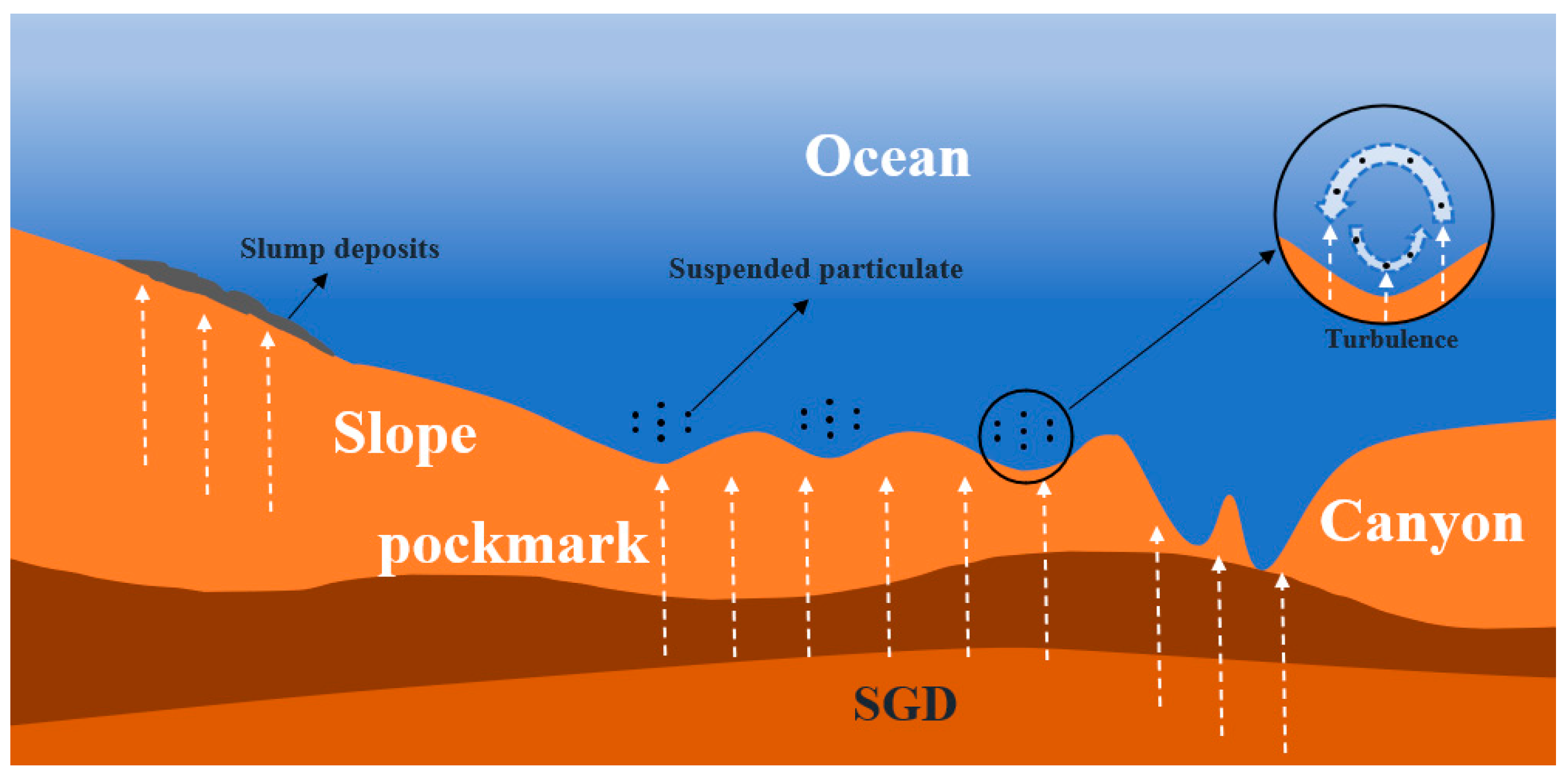
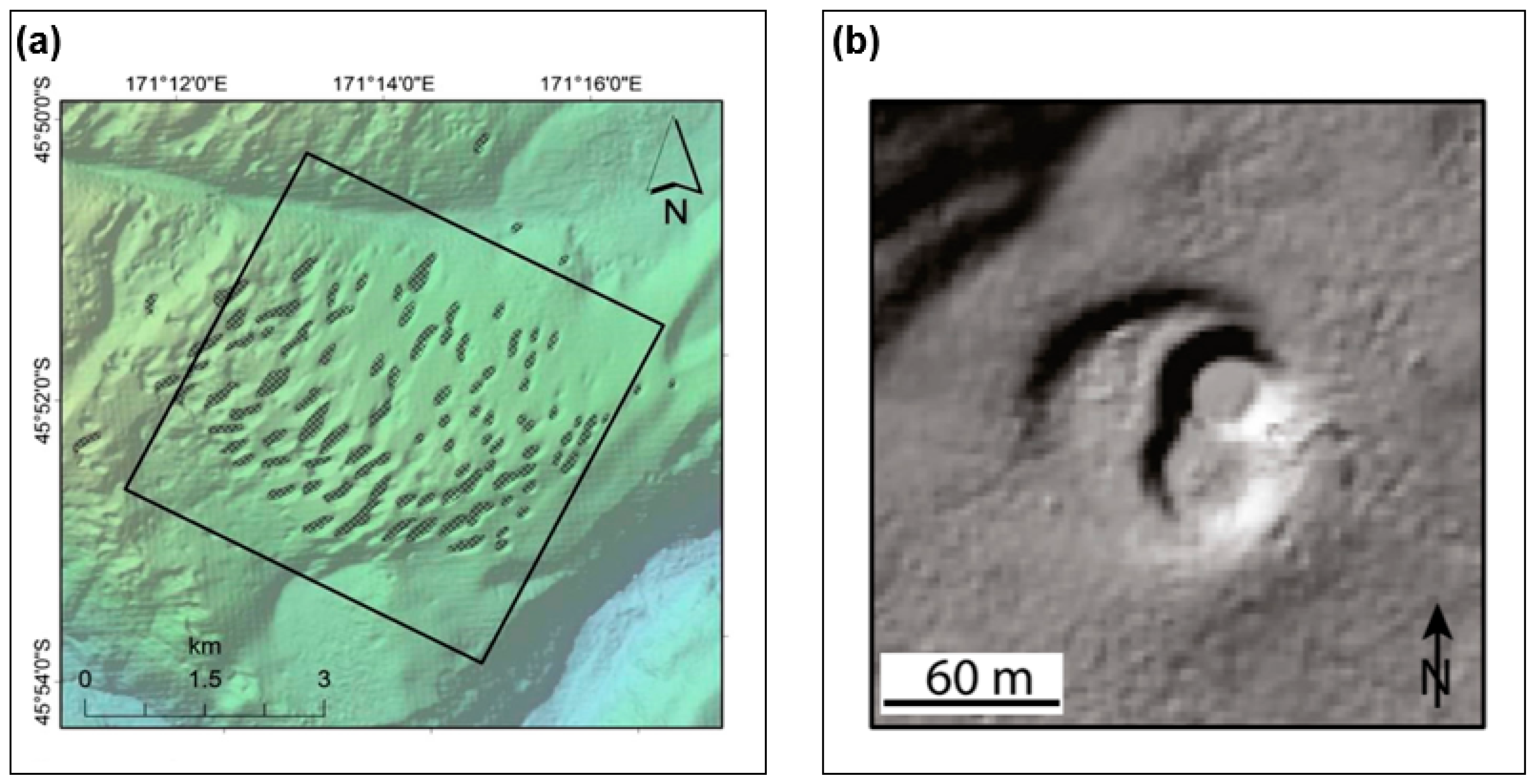
5.2. SGD Leads to the Formation of Pockmarks

The discharge of groundwater onto the seafloor surface exerts a substantial influence on the formation of collapse pockmarks. Tian et al. [77] indicated in their research that, under the action of storm waves, the pore-water pressure within the sediments accumulates continuously. When the excess pore-water pressure in the deep-seated sediments equals or surpasses the effective stress of the overlying sediments, fine-grained sediments are liable to experience abrupt uplift. This mechanism gives rise to a sorting effect, causing the particle size of the uplifted sediments to increase in accordance with the permeability. The seepage channels incessantly transport fluids and carry off fine-grained sediments, resulting in internal erosion of the seabed and facilitating the formation of collapse pockmarks.
The continuous advancement of geophysical exploration technologies has enhanced the detection capabilities for submarine hazards. Scholars have identified submarine pockmark formations at multiple locations (Figure 4). Virtasalo et al. [78] utilized technologies such as side-scan sonar to document the distribution of pockmarks on slopes in the southern Finnish Sea. By measuring the activity of the radioactive isotope Rn in seawater at a specific depth on the seabed, they discovered an increase in the activity concentration of seawater 222Rn at a depth of 1 m above, thereby confirming the occurrence of groundwater discharge from the submarine pockmark. Moreover, the pockmark served as migration pathways for local groundwater flow. Micallef et al. [15] employed multibeam bathymetry technology to record over 6800 submarine pockmarks in the eastern part of New Zealand and found extensive fluid migration (including methane and groundwater) within these pockmarks. These pockmarks were susceptible to morphological changes due to the influence of bottom currents, particularly those located on submarine slopes. Hillman et al. [14] deciphered the potential correlation between the geomorphology of submarine pockmark and groundwater discharge processes on the South Island of New Zealand by integrating multibeam bathymetry and three-dimensional seismic data. They posited that, under the influence of strong subtropical fronts, groundwater discharge intensified the cross-currents in submarine canyons, and there was a distinct correlation between the direction and velocity of the sea currents and the orientation of the submarine pockmark. Hoffmann et al. [13] detected groundwater discharge phenomena in the pockmarks of Wellington Harbour, New Zealand, through the combination of various geophysical methods and seabed sediment core sampling. They observed that multiple points at the bottom of the pockmark leaked simultaneously, and the upward-leaking groundwater could locally elevate the gas concentration near the seabed, potentially triggering gas escape into the water column. The freshwater discharged from the seabed could induce turbulence, making it difficult for seabed sediment particles to settle. These particles were identified as sediment plumes above the pockmarks in acoustic detection, which in turn could indicate the occurrence of groundwater discharge from the seabed.
Furthermore, extensive geophysical exploration efforts have been conducted in the coastal waters of the southern Baltic Sea, central England, and southern Italy [80,81,82]. These studies have confirmed an interactive relationship between the formation of submarine pockmarks and the seepage and migration of submarine fluids. Nevertheless, the methodology for quantitatively calculating and analyzing the influence of groundwater discharge on the formation of collapse pockmarks remains unclear and necessitates further research and validation.

5.3. SGD Triggers Seabed Erosion and Resuspension

At present, there are two mechanisms of seabed erosion. One is the traditional “wave-induced sediment entrainment and current-driven sediment transport” surface shear erosion mechanism. The actions of waves, tides, and ocean currents on the seabed manifest in the form of near-bottom shear stress τc. When the near-bottom shear stress τc surpasses the critical incipient shear stress τcr of the seabed surface sediments, the equilibrium state of the sediments is disrupted. Consequently, the sediments move through translation, saltation, or even suspension into the overlying water, thus becoming resuspended material [83,84]. The other mechanism takes into account the erosion mechanism resulting from wave-induced seepage liquefaction. The action of waves on seabed sediments not only supplies wave orbital shear stress, which erodes the surface sediments, but the cyclic pressure fluctuations also give rise to the generation of excess pore-water pressure within the seabed, thereby causing seabed liquefaction. This leads to a series of physical processes such as “transient transport” and “cumulative transport”. The contribution of wave-induced seabed transient liquefaction to sediment erosion and resuspension can reach 20–60%. The higher the degree of cumulative liquefaction, the greater the erosion coefficient, significantly influencing the erosion and resuspension of sediments [85,86,87]. A further understanding of the principles of wave-induced seepage liquefaction reveals that, due to the unique periodicity of waves, they facilitate the infiltration and exfiltration of seawater at the seabed surface. The near-bottom seawater exhibits a dynamic two-phase circulation and excretion within the seabed boundary layer and on the seabed surface. When extreme sea conditions occur, the intensity of this circulation and excretion increases, thereby raising the probability of seabed erosion.
River deltas, as hydrodynamic-coupled sensitive zones, exhibit significant erosion or deposition features in their seabed geomorphology due to the interactions among fluvial, groundwater, wave, and tidal systems. Taking the Mississippi River Delta (MRD, the largest river-dominated delta in North America) in the Gulf of Mexico as an example, its unique hydrogeological structure facilitates complex material–energy exchange mechanisms between terrestrial groundwater systems and nearshore marine environments. Core drilling and geophysical survey data reveal the presence of elongated paleochannels at the MRD front [88], where highly permeable stratigraphic units act as preferential pathways for SGD. The SGD process is accompanied by significant solute transport and geochemical exchange: Ho et al. [89] conducted seasonal porewater sampling at eight stations in the northwestern MRD and observed distinct dry–wet season migration patterns of trace metal concentrations (e.g., Fe, Mn) driven by SGD. The highest SGD fluxes occur in the western MRD, gradually declining eastward, with the highest SGD rates observed during summer and autumn [9]. Larsen et al. [90], using chemical isotope tracers in MRD samples, identified chloride anomalies indicating that seismic activity can trigger episodic upwelling of deep brine, leading to aquifer salinity anomalies. Seismic faults and fractures may alter aquifer properties and enhance localized fluid release [91]. Based on geophysical data, Li et al. [92,93] constructed a shallow stratigraphic model (50 m depth) for MRD, revealing that the main channel sand bodies serve as conduits for groundwater discharge, with an average SFGD rate of 1.0 × 10⁵−1.0 × 10⁶ m3/d. Kolker et al. [94] applied an isotopic mass balance model to estimate the total SGD rate in the MRD region at 1.0 × 10³ m3/s, dominated by RSGD. During flood–storm–typhoon compound events, sediment porewater pressure surges and reduced safety coefficients weaken effective stress, significantly destabilizing seabed sediment structures [95,96]. Long-term high-intensity submarine groundwater activity forms stable seepage channels, potentially inducing seabed erosion through sand boils and seepage failure of embankment foundations [97], posing major risks to coastal infrastructure. Fundamentally, deltaic seabed erosion is a multi-process-coupled engineering geological issue involving submarine seepage, necessitating urgent research on seepage–erosion dynamics under multi-sphere interactions.
Based on the comprehension of the impact mechanism of liquefaction-induced seepage on erosion, certain scholars have taken into account the influence of seepage by modifying the calculation formula for the critical erosion shear stress of sediments and integrating it into traditional erosion theory and computational models. Zhang et al. [98] incorporated the liquefaction-degree parameter into the traditional shear-erosion formula, thereby constructing a liquefaction–erosion resuspension calculation model. The calculation results suggest that the seepage resulting from groundwater discharge exerts an upward-thrust effect on the sandy-sediment surface, thus promoting the erosion and resuspension of sediments. Fox et al. [99] introduced the seepage-velocity parameter into the traditional critical erosion shear-stress calculation formula. Under the influence of groundwater seepage, the pore-pressure gradient not only supports the surface sediments but can also trigger the overall slippage of seabed blocks [100]. When the seepage effect is intense, the turbulent kinetic energy increases, and the turbulent energy diffusion accelerates, intensifying seabed erosion and augmenting the transport rate of suspended sediment. Solórzano-Rivas et al. [101] designed a mixed-convection model for the surface of high-permeability seabed sediments. They discovered that, due to the presence of density-driven forces, low-density groundwater ascends while high-density seawater descends. Accompanied by the buoyant plume of SFGD, permeable seabed-sediment particles may be suspended as they follow the rising low-density freshwater. Tang et al. [102] utilized a ring flume to simulate the process of internal erosion and resuspension of seabed with varying degrees of consolidation under the action of seepage. By applying the seepage force to soil beds that had completed drainage and consolidation in a short period, they found that cracks emerged on the soil-bed surface. When the soil bed was damaged, seepage outlets appeared on the surface, a large quantity of sediment was discharged, and the soil underwent vertical erosion. Concurrently, the concentration of suspended sediment in the overlying water increased rapidly.
Currently, the seepage action in the seabed is predominantly ascribed to the cyclic loading induced by waves. Under actual marine conditions, the seepage intensity resulting from the recirculation and discharge of seawater might be even more substantial. How does the seepage action during the SGD process exert an impact on the erosion stability of seabed sediments? To what extent does it contribute to seabed erosion and resuspension? And how can these effects be quantitatively evaluated? These questions demand further exploration and resolution.

6. Conclusions

The total area of China’s offshore waters amounts to approximately 4.7 million square kilometers, featuring diverse geological and geomorphological characteristics on the seabed. SGD is an important factor influencing the evolution of the seabed, with its effects being persistent and manifesting in various forms. It also has a significant impact on the ecological environment of the nearshore areas. However, owing to the unique geographical location and geological structure of China’s coastal zone, the research on the mechanisms of seabed instability triggered by SGD is not yet comprehensive. In particular, the changes in the amount and rate of coastal groundwater discharge under severe weather conditions such as heavy rain and storm surges, as well as the mechanisms of seabed instability potentially induced by various hydrodynamic processes, urgently call for further refinement.
Overall, several aspects still require further research:
(1) Conduct a more in-depth investigation into the individual mechanisms through which SGD influences seabed stability. Devise a series of comprehensive indoor scaled-down physical simulation experiments and numerical models to explore the impact mechanisms of SGD rates on seabed erosion, resuspension, the formation and evolution of collapse pockmarks, and submarine slope instability under the control of single physical drivers, such as aquifer characteristics, the seasonal fluctuations of groundwater, waves, tides, and the density differences between saltwater and freshwater. Analyze and contrast the influences of different factors to furnish a scientific basis for the prediction and assessment of seabed stability.
(2) Delve deeper into the coupled mechanisms of SGD’s impact on seabed stability. Establish a direct and efficient in situ long-term joint monitoring system for SGD and submarine geohazards to acquire the most intuitive field data. Through multi-dimensional monitoring and analysis, comprehensively formulate a mechanism for the generation of submarine geohazard chains, with SGD rates and discharge volumes serving as the primary causative factors.
(3) Through SGD-related research, establish the connection between the seabed surface fluid migration system and marine hydrodynamics, geological structures, and human engineering activities. Construct a warning and risk prevention and control system for typical marine geohazards against the backdrop of seabed fluid migration. Strengthen the research on marine geohazard issues involving multi-disciplinary intersections, multi-factor correlations, and multi-layer couplings, so as to provide a scientific basis for the safe construction of marine engineering and the enhancement of technical levels for the prevention and control of marine geohazards.

Author Contributions

Conceptualization, H.S., Y.Q. and Y.J.; supervision, Y.J. and H.L.; writing—original draft, Z.J.; writing—review and editing, Z.J., H.S., H.L., Z.Z., L.J., S.W., Y.Q. and Y.J. All authors have read and agreed to the published version of the manuscript.

Funding

This research was funded by the project of National Natural Science Foundation of China (NO. 42277137).

Institutional Review Board Statement

Not applicable.

Informed Consent Statement

Not applicable.

Data Availability Statement

The original contributions presented in this study are included in the article. Further inquiries can be directed to the corresponding author.

Conflicts of Interest

The authors declare no conflicts of interest.

References

  1. Moore, W.S. The Effect of Submarine Groundwater Discharge on the Ocean. Annu. Rev. Mar. Sci. 2010, 2, 59–88. [Google Scholar] [CrossRef]
  2. Li, H.L.; Wang, X.J. Submarine groundwater discharge: A review. Adv. Earth Sci. 2015, 30, 636–646. [Google Scholar]
  3. Зекцер, И.С.; Liu, J.C. Marine hydrogeological problems. World Sci. 1986, 10, 36. [Google Scholar]
  4. Burnett, W.C.; Bokuniewicz, H.; Huettel, M.; Moore, W.S.; Taniguchi, M. Groundwater and Pore Water Inputs to the Coastal Zone. Biogeochemistry 2003, 66, 3–33. [Google Scholar] [CrossRef]
  5. Harishidayat, D.; Al-Shuhail, A.; Randazzo, G.; Lanza, S.; Muzirafuti, A. Reconstruction of Land and Marine Features by Seismic and Surface Geomorphology Techniques. Appl. Sci. 2022, 12, 9611. [Google Scholar] [CrossRef]
  6. Wang, R.; Wang, Y.; Ye, Q.; Zhang, Y. Analysis of Characteristics and Main Controlling Factors of Shallow Geological Hazards in the Zhongsha Islands Region of the South China Sea. J. Mar. Sci. Eng. 2024, 12, 2236. [Google Scholar] [CrossRef]
  7. Kwon, E.Y.; Kim, G.; Primeau, F.; Moore, W.S.; Cho, H.; DeVries, T.; Sarmiento, J.L.; Charette, M.A.; Cho, Y. Global Estimate of Submarine Groundwater Discharge Based on an Observationally Constrained Radium Isotope Model. Geophys. Res. Lett. 2014, 41, 8438–8444. [Google Scholar] [CrossRef]
  8. Tait, D.R.; Sippo, J.Z.; Jeffrey, L.C.; Maher, D.T.; Mukherjee, A.; Ralph, C.; Das, K. Groundwater Discharge and Bank Overtopping Drive Large Carbon Exports from Indian Sundarban Mangroves. Sci. Total Environ. 2024, 955, 176463. [Google Scholar] [CrossRef]
  9. Moody, A.; Moore, W.S.; Pierce, T.; Shiller, A.M. The Effects of Submarine Groundwater Discharge and the Bonnet Carré Spillway on Nutrient Dynamics in the Western Mississippi Sound. Sci. Total Environ. 2024, 953, 176080. [Google Scholar] [CrossRef]
  10. Xue, Y.; Zhang, Y.; Zhang, M.; Wang, X.; Xiao, K.; Luo, M.; Li, H. Submarine Groundwater Discharge and Associated Metal Elements into an Urbanized Bay. Mar. Pollut. Bull. 2023, 192, 115092. [Google Scholar] [CrossRef]
  11. Anthony, E.J.; Julian, M. The 1979 Var Delta Landslide on the French Riviera: A Retrospective Analysis. J. Coast. Res. 1997, 13, 27–35. [Google Scholar]
  12. Oehler, T.; Mogollón, J.M.; Moosdorf, N.; Winkler, A.; Kopf, A.; Pichler, T. Submarine Groundwater Discharge within a Landslide Scar at the French Mediterranean Coast. Estuar. Coast. Shelf Sci. 2017, 198, 128–137. [Google Scholar] [CrossRef]
  13. Hoffmann, J.J.L.; Mountjoy, J.J.; Spain, E.; Gall, M.; Tait, L.W.; Ladroit, Y.; Micallef, A. Fresh Submarine Groundwater Discharge Offshore Wellington (New Zealand): Hydroacoustic Characteristics and Its Influence on Seafloor Geomorphology. Front. Mar. Sci. 2023, 10, 1204182. [Google Scholar] [CrossRef]
  14. Hillman, J.I.T.; Gorman, A.R.; Pecher, I.A. Geostatistical Analysis of Seafloor Depressions on the Southeast Margin of New Zealand’s South Island—Investigating the Impact of Dynamic near Seafloor Processes on Geomorphology. Mar. Geol. 2015, 360, 70–83. [Google Scholar] [CrossRef]
  15. Micallef, A.; Averes, T.; Hoffmann, J.; Crutchley, G.; Mountjoy, J.J.; Person, M.; Cohen, D.; Woelz, S.; Bury, S.J.; Ahaneku, C.V.; et al. Multiple Drivers and Controls of Pockmark Formation across the Canterbury Margin, New Zealand. Basin Res. 2022, 34, 1374–1399. [Google Scholar] [CrossRef]
  16. Stachelhaus, S.L.; Moran, S.B.; Kelly, R.P. An Evaluation of the Efficacy of Radium Isotopes as Tracers of Submarine Groundwater Discharge to Southern Rhode Island’s Coastal Ponds. Mar. Chem. 2012, 130–131, 49–61. [Google Scholar] [CrossRef]
  17. Chen, D.; Zhang, G.; Dong, D.; Zhao, M.; Wang, X. Widespread Fluid Seepage Related to Buried Submarine Landslide Deposits in the Northwestern South China Sea. Geophys. Res. Lett. 2022, 49, e2021GL096584. [Google Scholar] [CrossRef]
  18. Chen, T.; Li, Z.; Nai, H.; Liu, H.; Shan, H.; Jia, Y. Seabed Dynamic Responses Induced by Nonlinear Internal Waves: New Insights and Future Directions. J. Mar. Sci. Eng. 2023, 11, 395. [Google Scholar] [CrossRef]
  19. Zhu, C.; Li, Q.; Li, Z.; Duan, M.; Li, S.; Zhou, Q.; Geng, M.; Chen, J.; Jia, Y. Seabed Fluid Flow in the China Seas. Front. Mar. Sci. 2023, 10, 1158685. [Google Scholar] [CrossRef]
  20. Moore, W.S. Large Groundwater Inputs to Coastal Waters Revealed by 226Ra Enrichments. Nature 1996, 380, 612–614. [Google Scholar] [CrossRef]
  21. Garrison, G.H.; Glenn, C.R.; McMurtry, G.M. Measurement of Submarine Groundwater Discharge in Kahana Bay, O’ahu, Hawai’i. Limnol. Oceanogr. 2003, 48, 920–928. [Google Scholar] [CrossRef]
  22. Shaw, T.J.; Moore, W.S.; Kloepfer, J.; Sochaski, M.A. The Flux of Barium to the Coastal Waters of the Southeastern USA: The Importance of Submarine Groundwater Discharge. Geochim. Cosmochim. Acta 1998, 62, 3047–3054. [Google Scholar] [CrossRef]
  23. Santos, I.R.; Burnett, W.C.; Dittmar, T.; Suryaputra, I.G.N.A.; Chanton, J. Tidal Pumping Drives Nutrient and Dissolved Organic Matter Dynamics in a Gulf of Mexico Subterranean Estuary. Geochim. Cosmochim. Acta 2009, 73, 1325–1339. [Google Scholar] [CrossRef]
  24. Mwashote, B.M.; Murray, M.; Burnett, W.C.; Chanton, J.; Kruse, S.; Forde, A. Submarine Groundwater Discharge in the Sarasota Bay System: Its Assessment and Implications for the Nearshore Coastal Environment. Cont. Shelf Res. 2013, 53, 63–76. [Google Scholar] [CrossRef]
  25. Kim, G.; Kim, J.-S.; Hwang, D.-W. Submarine Groundwater Discharge from Oceanic Islands Standing in Oligotrophic Oceans: Implications for Global Biological Production and Organic Carbon Fluxes. Limnol. Oceanogr. 2011, 56, 673–682. [Google Scholar] [CrossRef]
  26. Dulaiova, H.; Gonneea, M.E.; Henderson, P.B.; Charette, M.A. Geochemical and Physical Sources of Radon Variation in a Subterranean Estuary—Implications for Groundwater Radon Activities in Submarine Groundwater Discharge Studies. Mar. Chem. 2008, 110, 120–127. [Google Scholar] [CrossRef]
  27. Rodellas, V.; Garcia-Orellana, J.; Tovar-Sánchez, A.; Basterretxea, G.; López-Garcia, J.M.; Sánchez-Quiles, D.; Garcia-Solsona, E.; Masqué, P. Submarine Groundwater Discharge as a Source of Nutrients and Trace Metals in a Mediterranean Bay (Palma Beach, Balearic Islands). Mar. Chem. 2014, 160, 56–66. [Google Scholar] [CrossRef]
  28. Baudron, P.; Cockenpot, S.; Lopez-Castejon, F.; Radakovitch, O.; Gilabert, J.; Mayer, A.; Garcia-Arostegui, J.L.; Martinez-Vicente, D.; Leduc, C.; Claude, C. Combining Radon, Short-Lived Radium Isotopes and Hydrodynamic Modeling to Assess Submarine Groundwater Discharge from an Anthropized Semiarid Watershed to a Mediterranean Lagoon (Mar Menor, SE Spain). J. Hydrol. 2015, 525, 55–71. [Google Scholar] [CrossRef]
  29. Trezzi, G.; Garcia-Orellana, J.; Rodellas, V.; Santos-Echeandia, J.; Tovar-Sánchez, A.; Garcia-Solsona, E.; Masqué, P. Submarine Groundwater Discharge: A Significant Source of Dissolved Trace Metals to the North Western Mediterranean Sea. Mar. Chem. 2016, 186, 90–100. [Google Scholar] [CrossRef]
  30. Rodellas, V.; Garcia-Orellana, J.; Trezzi, G.; Masqué, P.; Stieglitz, T.C.; Bokuniewicz, H.; Cochran, J.K.; Berdalet, E. Using the Radium Quartet to Quantify Submarine Groundwater Discharge and Porewater Exchange. Geochim. Cosmochim. Acta 2017, 196, 58–73. [Google Scholar] [CrossRef]
  31. Tamborski, J.; Bejannin, S.; Garcia-Orellana, J.; Souhaut, M.; Charbonnier, C.; Anschutz, P.; Pujo-Pay, M.; Conan, P.; Crispi, O.; Monnin, C.; et al. A Comparison between Water Circulation and Terrestrially-Driven Dissolved Silica Fluxes to the Mediterranean Sea Traced Using Radium Isotopes. Geochim. Cosmochim. Acta 2018, 238, 496–515. [Google Scholar] [CrossRef]
  32. Kim, G.; Ryu, J.-W.; Yang, H.-S.; Yun, S.-T. Submarine Groundwater Discharge (SGD) into the Yellow Sea Revealed by 228Ra and 226Ra Isotopes: Implications for Global Silicate Fluxes. Earth Planet. Sci. Lett. 2005, 237, 156–166. [Google Scholar] [CrossRef]
  33. Zhang, J.; Mandal, A.K. Linkages between Submarine Groundwater Systems and the Environment. Curr. Opin. Environ. Sustain. 2012, 4, 219–226. [Google Scholar] [CrossRef]
  34. Moore, W.S.; Sarmiento, J.L.; Key, R.M. Submarine Groundwater Discharge Revealed by 228Ra Distribution in the Upper Atlantic Ocean. Nat. Geosci. 2008, 1, 309–311. [Google Scholar] [CrossRef]
  35. Michael, H.A.; Charette, M.A.; Harvey, C.F. Patterns and Variability of Groundwater Flow and Radium Activity at the Coast: A Case Study from Waquoit Bay, Massachusetts. Mar. Chem. 2011, 127, 100–114. [Google Scholar] [CrossRef]
  36. Taniguchi, M.; Burnett, W.C.; Smith, C.F.; Paulsen, R.J.; O’Rourke, D.; Krupa, S.L.; Christoff, J.L. Spatial and Temporal Distributions of Submarine Groundwater Discharge Rates Obtained from Various Types of Seepage Meters at a Site in the Northeastern Gulf of Mexico. Biogeochemistry 2003, 66, 35–53. [Google Scholar] [CrossRef]
  37. Beck, A.J.; Rapaglia, J.P.; Cochran, J.K.; Bokuniewicz, H.J.; Yang, S. Submarine Groundwater Discharge to Great South Bay, NY, Estimated Using Ra Isotopes. Mar. Chem. 2008, 109, 279–291. [Google Scholar] [CrossRef]
  38. Ganju, N.K. A Novel Approach for Direct Estimation of Fresh Groundwater Discharge to an Estuary: Estimation of Groundwater Discharge. Geophys. Res. Lett. 2011, 38, L11402. [Google Scholar] [CrossRef]
  39. Garcia-Orellana, J.; Cochran, J.K.; Bokuniewicz, H.; Daniel, J.W.R.; Rodellas, V.; Heilbrun, C. Evaluation of 224Ra as a Tracer for Submarine Groundwater Discharge in Long Island Sound (NY). Geochim. Cosmochim. Acta 2014, 141, 314–330. [Google Scholar] [CrossRef]
  40. Blanco, A.C.; Watanabe, A.; Nadaoka, K.; Motooka, S.; Herrera, E.C.; Yamamoto, T. Estimation of Nearshore Groundwater Discharge and Its Potential Effects on a Fringing Coral Reef. Mar. Pollut. Bull. 2011, 62, 770–785. [Google Scholar] [CrossRef]
  41. Zhang, Y.; Wang, X.; Xue, Y.; Zou, C.; Luo, M.; Li, G.; Li, L.; Cui, L.; Li, H. Advances in the Study of Submarine Groundwater Discharge (SGD) in China. Sci. China Earth Sci. 2022, 65, 1948–1960. [Google Scholar] [CrossRef]
  42. Ma, Q.; Li, H.; Wang, X.; Wang, C.; Wan, L.; Wang, X.; Jiang, X. Estimation of Seawater–Groundwater Exchange Rate: Case Study in a Tidal Flat with a Large-Scale Seepage Face (Laizhou Bay, China). Hydrogeol. J. 2015, 23, 265–275. [Google Scholar] [CrossRef]
  43. Wang, X.; Li, H.; Jiao, J.J.; Barry, D.A.; Li, L.; Luo, X.; Wang, C.; Wan, L.; Wang, X.; Jiang, X.; et al. Submarine Fresh Groundwater Discharge into Laizhou Bay Comparable to the Yellow River Flux. Sci. Rep. 2015, 5, 8814. [Google Scholar] [CrossRef]
  44. Guo, Z.R.; Ma, Z.Y.; Zhang, B.; Yuan, X.J.; Liu, H.T.; Liu, J. Tracing Submarine Groundwater Discharge and Associated Nutrient Fluxes into Jiaozhou Bay by Continuous 222Rn Measurements. Earth Sci. J. China Univ. Geosci. 2013, 38, 1073–1080+1090. [Google Scholar] [CrossRef]
  45. Taniguchi, M.; Ishitobi, T.; Chen, J.; Onodera, S.; Miyaoka, K.; Burnett, W.C.; Peterson, R.; Liu, G.; Fukushima, Y. Submarine Groundwater Discharge from the Yellow River Delta to the Bohai Sea, China. J. Geophys. Res. Oceans 2008, 113, 2007JC004498. [Google Scholar] [CrossRef]
  46. Peterson, R.N.; Burnett, W.C.; Taniguchi, M.; Chen, J.; Santos, I.R.; Ishitobi, T. Radon and Radium Isotope Assessment of Submarine Groundwater Discharge in the Yellow River Delta, China. J. Geophys. Res. Oceans 2008, 113, 2008JC004776. [Google Scholar] [CrossRef]
  47. Xu, B.; Burnett, W.; Dimova, N.; Diao, S.; Mi, T.; Jiang, X.; Yu, Z. Hydrodynamics in the Yellow River Estuary via Radium Isotopes: Ecological Perspectives. Cont. Shelf Res. 2013, 66, 19–28. [Google Scholar] [CrossRef]
  48. Xu, B.; Xia, D.; Burnett, W.C.; Dimova, N.T.; Wang, H.; Zhang, L.; Gao, M.; Jiang, X.; Yu, Z. Natural 222Rn and 220Rn Indicate the Impact of the Water–Sediment Regulation Scheme (WSRS) on Submarine Groundwater Discharge in the Yellow River Estuary, China. Appl. Geochem. 2014, 51, 79–85. [Google Scholar] [CrossRef]
  49. Guo, Z.R.; Huang, L.; Yuan, X.J.; Liu, H.T.; Li, K.P. Estimating submarine groundwater discharge to the Jiulong River estuary using Ra isotopes. Adv. Water Sci. 2011, 22, 118–125. [Google Scholar] [CrossRef]
  50. Gu, H.; Moore, W.S.; Zhang, L.; Du, J.; Zhang, J. Using Radium Isotopes to Estimate the Residence Time and the Contribution of Submarine Groundwater Discharge (SGD) in the Changjiang Effluent Plume, East China Sea. Cont. Shelf Res. 2012, 35, 95–107. [Google Scholar] [CrossRef]
  51. Liu, J.; Du, J.; Yi, L. Ra Tracer-Based Study of Submarine Groundwater Discharge and Associated Nutrient Fluxes into the Bohai Sea, China: A Highly Human-Affected Marginal Sea. J. Geophys. Res. Oceans 2017, 122, 8646–8660. [Google Scholar] [CrossRef]
  52. Luo, X.; Jiao, J.J.; Liu, Y.; Zhang, X.; Liang, W.; Tang, D. Evaluation of Water Residence Time, Submarine Groundwater Discharge, and Maximum New Production Supported by Groundwater Borne Nutrients in a Coastal Upwelling Shelf System. J. Geophys. Res. Oceans 2018, 123, 631–655. [Google Scholar] [CrossRef]
  53. Wang, Q.; Zhang, X.; Wang, X.; Xiao, K.; Zhang, Y.; Wang, L.; Kuang, X.; Li, H. Quantification of the Water Age and Submarine Groundwater Discharge in a Typical Semi-Enclosed Bay Using Stable Oxygen (18O) and Radioactive Radium (228Ra) Isotopes. J. Hydrol. 2021, 603, 127088. [Google Scholar] [CrossRef]
  54. Wang, G.; Wang, S.; Wang, Z.; Jing, W. Significance of Submarine Groundwater Discharge in Nutrient Budgets in Tropical Sanya Bay, China. Sustainability 2018, 10, 380. [Google Scholar] [CrossRef]
  55. Wang, G.; Han, A.; Chen, L.; Tan, E.; Lin, H. Fluxes of Dissolved Organic Carbon and Nutrients via Submarine Groundwater Discharge into Subtropical Sansha Bay, China. Estuar. Coast. Shelf Sci. 2018, 207, 269–282. [Google Scholar] [CrossRef]
  56. Wang, Q.; Li, H.; Zhang, Y.; Wang, X.; Zhang, C.; Xiao, K.; Qu, W. Evaluations of Submarine Groundwater Discharge and Associated Heavy Metal Fluxes in Bohai Bay, China. Sci. Total Environ. 2019, 695, 133873. [Google Scholar] [CrossRef]
  57. Wu, Z.; Zhou, H.; Zhang, S.; Liu, Y. Using 222Rn to Estimate Submarine Groundwater Discharge (SGD) and the Associated Nutrient Fluxes into Xiangshan Bay, East China Sea. Mar. Pollut. Bull. 2013, 73, 183–191. [Google Scholar] [CrossRef] [PubMed]
  58. Wang, G.; Wang, Z.; Zhai, W.; Moore, W.S.; Li, Q.; Yan, X.; Qi, D.; Jiang, Y. Net Subterranean Estuarine Export Fluxes of Dissolved Inorganic C, N, P, Si, and Total Alkalinity into the Jiulong River Estuary, China. Geochim. Cosmochim. Acta 2015, 149, 103–114. [Google Scholar] [CrossRef]
  59. Liu, J.; Du, J.; Wu, Y.; Liu, S. Nutrient Input through Submarine Groundwater Discharge in Two Major Chinese Estuaries: The Pearl River Estuary and the Changjiang River Estuary. Estuar. Coast. Shelf Sci. 2018, 203, 17–28. [Google Scholar] [CrossRef]
  60. Tian, Z.; Jia, Y.; Zhu, C.; Lu, L.; Guo, X.; Feng, X.; Wang, H.; Wang, H.; He, M.; Peng, J. Research Progress and Prospects of Geohazard Mechanism and Risk Prevention Related to Seabed Fluid Migration. Chin. J. Eng. Sci. 2023, 25, 131. [Google Scholar] [CrossRef]
  61. Snyder, H. Literature Review as a Research Methodology: An Overview and Guidelines. J. Bus. Res. 2019, 104, 333–339. [Google Scholar] [CrossRef]
  62. Santos, I.R.; Erler, D.; Tait, D.; Eyre, B.D. Breathing of a Coral Cay: Tracing Tidally Driven Seawater Recirculation in Permeable Coral Reef Sediments. J. Geophys. Res. Oceans 2010, 115, 2010JC006510. [Google Scholar] [CrossRef]
  63. Xin, P.; Wang, S.S.J.; Robinson, C.; Li, L.; Wang, Y.-G.; Barry, D.A. Memory of Past Random Wave Conditions in Submarine Groundwater Discharge. Geophys. Res. Lett. 2014, 41, 2401–2410. [Google Scholar] [CrossRef]
  64. Robinson, C.; Xin, P.; Li, L.; Barry, D.A. Groundwater Flow and Salt Transport in a Subterranean Estuary Driven by Intensified Wave Conditions: Wave-Driven Flow and Transport in a Subterranean Estuary. Water Resour. Res. 2014, 50, 165–181. [Google Scholar] [CrossRef]
  65. Werner, A.D.; Bakker, M.; Post, V.E.A.; Vandenbohede, A.; Lu, C.; Ataie-Ashtiani, B.; Simmons, C.T.; Barry, D.A. Seawater Intrusion Processes, Investigation and Management: Recent Advances and Future Challenges. Adv. Water Resour. 2013, 51, 3–26. [Google Scholar] [CrossRef]
  66. Sultan, N.; Garziglia, S.; Bompais, X.; Woerther, P.; Witt, C.; Kopf, A.; Migeon, S. Transient Groundwater Flow Through a Coastal Confined Aquifer and Its Impact on Nearshore Submarine Slope Instability. J. Geophys. Res. Earth Surf. 2020, 125, e2020JF005654. [Google Scholar] [CrossRef]
  67. Holz Boffo, C.; Bayer Da Silva, D.; Manica, R.; De Oliveira Borges, A.L.; Roessler Viana, A. Submarine Slope Destabilization and Gully Formation by Water Sapping: Physical Simulation of an Underestimated Trigger of Subaqueous Sediment Gravity Flows. Sedimentology 2022, 69, 1599–1625. [Google Scholar] [CrossRef]
  68. Saadatkhah, N.; Kassim, A.; Siat, Q.A.; Micallef, A. Salt Leaching by Freshwater and Its Impact on Seafloor Stability: An Experimental Investigation. Mar. Geol. 2023, 455, 106959. [Google Scholar] [CrossRef]
  69. Micallef, A.; Person, M.; Gupta, S.; Saadatkhah, N.; Camille, A.; Gratacós, Ò. Can Offshore Meteoric Groundwater Generate Mechanical Instabilities in Passive Continental Margins? J. Geophys. Res. Earth Surf. 2023, 128, e2022JF006954. [Google Scholar] [CrossRef]
  70. Dalai, C.; Dhar, A. Impact of Beach Face Slope Variation on Saltwater Intrusion Dynamics in Unconfined Aquifer under Tidal Boundary Condition. Flow Meas. Instrum. 2023, 89, 102298. [Google Scholar] [CrossRef]
  71. Stegmann, S.; Sultan, N.; Kopf, A.; Apprioual, R.; Pelleau, P. Hydrogeology and Its Effect on Slope Stability along the Coastal Aquifer of Nice, France. Mar. Geol. 2011, 280, 168–181. [Google Scholar] [CrossRef]
  72. Smith, C.A.; Larsson, O.; Engdahl, M. Early Holocene Coastal Landslides Linked to Land Uplift in Western Sweden. Geogr. Ann. Ser. Phys. Geogr. 2017, 99, 288–311. [Google Scholar] [CrossRef]
  73. Paull, C.K.; Dallimore, S.R.; Caress, D.W.; Gwiazda, R.; Lundsten, E.; Anderson, K.; Melling, H.; Jin, Y.K.; Duchesne, M.J.; Kang, S.-G.; et al. A 100-Km Wide Slump along the Upper Slope of the Canadian Arctic Was Likely Preconditioned for Failure by Brackish Pore Water Flushing. Mar. Geol. 2021, 435, 106453. [Google Scholar] [CrossRef]
  74. Ran, Q.; Qian, Q.; Wang, G.; Fu, X.; Su, D. Analytical Solution for Slope Instability Assessment Considering Impact of Confined Aquifer. J. Cent. S. Univ. 2015, 22, 1502–1509. [Google Scholar] [CrossRef]
  75. Pelascini, L.; Steer, P.; Mouyen, M.; Longuevergne, L. Finite-Hillslope Analysis of Landslides Triggered by Excess Pore Water Pressure: The Roles of Atmospheric Pressure and Rainfall Infiltration during Typhoons. Nat. Hazards Earth Syst. Sci. 2022, 22, 3125–3141. [Google Scholar] [CrossRef]
  76. Boffo, C.H.; De Oliveira, T.A.; Da Silva, D.B.; Manica, R.; Borges, A.L.D.O. Continental-Slope Instability Triggered by Seepage: An Experimental Approach. J. Sediment. Res. 2020, 90, 921–937. [Google Scholar] [CrossRef]
  77. Tian, Z.; Guo, X.; Qiao, L.; Yu, L.; Xu, G.; Liu, T. Formation Mechanism of Large Pockmarks in the Subaqueous Yellow River Delta. Mar. Georesources Geotechnol. 2019, 37, 651–659. [Google Scholar] [CrossRef]
  78. Virtasalo, J.J.; Schröder, J.F.; Luoma, S.; Majaniemi, J.; Mursu, J.; Scholten, J. Submarine Groundwater Discharge Site in the First Salpausselkä Ice-Marginal Formation, South Finland. Solid Earth 2019, 10, 405–423. [Google Scholar] [CrossRef]
  79. Loher, M.; Reusch, A.; Strasser, M. Long-term Pockmark Maintenance by Fluid Seepage and Subsurface Sediment Mobilization—Sedimentological Investigations in Lake Neuchâtel. Sedimentology 2016, 63, 1168–1186. [Google Scholar] [CrossRef]
  80. Idczak, J.; Brodecka-Goluch, A.; Łukawska-Matuszewska, K.; Graca, B.; Gorska, N.; Klusek, Z.; Pezacki, P.D.; Bolałek, J. A Geophysical, Geochemical and Microbiological Study of a Newly Discovered Pockmark with Active Gas Seepage and Submarine Groundwater Discharge (MET1-BH, Central Gulf of Gdańsk, Southern Baltic Sea). Sci. Total Environ. 2020, 742, 140306. [Google Scholar] [CrossRef]
  81. Goff, J.A. Modern and Fossil Pockmarks in the New England Mud Patch: Implications for Submarine Groundwater Discharge on the Middle Shelf. Geophys. Res. Lett. 2019, 46, 12213–12220. [Google Scholar] [CrossRef]
  82. Buongiorno Nardelli, B.; Budillon, F.; Watteaux, R.; Ciccone, F.; Conforti, A.; De Falco, G.; Di Martino, G.; Innangi, S.; Tonielli, R.; Iudicone, D. Pockmark Morphology and Turbulent Buoyant Plumes at a Submarine Spring. Cont. Shelf Res. 2017, 148, 19–36. [Google Scholar] [CrossRef]
  83. Maa, P.-Y.; Mehta, A.J. Mud Erosion by Waves: A Laboratory Study. Cont. Shelf Res. 1987, 7, 1269–1284. [Google Scholar] [CrossRef]
  84. Henry, C.; Minier, J.-P. Progress in Particle Resuspension from Rough Surfaces by Turbulent Flows. Prog. Energy Combust. Sci. 2014, 45, 1–53. [Google Scholar] [CrossRef]
  85. Jia, Y.; Zhang, L.; Zheng, J.; Liu, X.; Jeng, D.-S.; Shan, H. Effects of Wave-Induced Seabed Liquefaction on Sediment Re-Suspension in the Yellow River Delta. Ocean Eng. 2014, 89, 146–156. [Google Scholar] [CrossRef]
  86. Zhang, S.; Jia, Y.; Wang, Z.; Wen, M.; Lu, F.; Zhang, Y.; Liu, X.; Shan, H. Wave Flume Experiments on the Contribution of Seabed Fluidization to Sediment Resuspension. Acta Oceanol. Sin. 2018, 37, 80–87. [Google Scholar] [CrossRef]
  87. Zhang, S.; Jia, Y.; Lu, F.; Zhang, Y.; Zhang, S.; Peng, Z. Effects of Upward Seepage on the Resuspension of Consolidated Silty Sediments in the Yellow River Delta. J. Coast. Res. 2019, 36, 372. [Google Scholar] [CrossRef]
  88. Van Arsdale, R.; Cox, R.; Lumsden, D.; Kwon, Y. The Past, Present, and Future Mississippi River. J. Geol. 2023, 131, 187–198. [Google Scholar] [CrossRef]
  89. Ho, P.; Shim, M.J.; Howden, S.D.; Shiller, A.M. Temporal and Spatial Distributions of Nutrients and Trace Elements (Ba, Cs, Cr, Fe, Mn, Mo, U, V and Re) in Mississippi Coastal Waters: Influence of Hypoxia, Submarine Groundwater Discharge, and Episodic Events. Cont. Shelf Res. 2019, 175, 53–69. [Google Scholar] [CrossRef]
  90. Larsen, D.; Paul, J.; Cox, R. Geochemical and Isotopic Evidence for Upward Flow of Saline Fluid to the Mississippi River Valley Alluvial Aquifer, Southeastern Arkansas, USA. Hydrogeol. J. 2021, 29, 1421–1444. [Google Scholar] [CrossRef]
  91. Rosen, M.R.; Binda, G.; Archer, C.; Pozzi, A.; Michetti, A.M.; Noble, P.J. Mechanisms of Earthquake-Induced Chemical and Fluid Transport to Carbonate Groundwater Springs After Earthquakes. Water Resour. Res. 2018, 54, 5225–5244. [Google Scholar] [CrossRef]
  92. Li, A.; Tsai, F.T.-C.; Yuill, B.T.; Wu, C. A Three-Dimensional Stratigraphic Model of the Mississippi River Delta, USA: Implications for River Deltaic Hydrogeology. Hydrogeol. J. 2020, 28, 2341–2358. [Google Scholar] [CrossRef]
  93. Li, A.; Tsai, F.T.-C. Understanding Dynamics of Groundwater Flows in the Mississippi River Delta. J. Hydrol. 2020, 583, 124616. [Google Scholar] [CrossRef]
  94. Kolker, A.S.; Cable, J.E.; Johannesson, K.H.; Allison, M.A.; Inniss, L.V. Pathways and Processes Associated with the Transport of Groundwater in Deltaic Systems. J. Hydrol. 2013, 498, 319–334. [Google Scholar] [CrossRef]
  95. Chamberlain, E.L.; Törnqvist, T.E.; Shen, Z.; Mauz, B.; Wallinga, J. Anatomy of Mississippi Delta Growth and Its Implications for Coastal Restoration. Sci. Adv. 2018, 4, eaar4740. [Google Scholar] [CrossRef] [PubMed]
  96. Locci-Lopez, D.; Lorenzo, J.M. Seepage-Induced Pore Pressure Variations Beneath an Earthen Levee Measured with a Novel Seismic Tool. Geosciences 2023, 13, 20. [Google Scholar] [CrossRef]
  97. Esposito, C.R.; Georgiou, I.Y.; Kolker, A.S. Hydrodynamic and Geomorphic Controls on Mouth Bar Evolution. Geophys. Res. Lett. 2013, 40, 1540–1545. [Google Scholar] [CrossRef]
  98. Zhang, M.; Yu, G.; La Rovere, A.; Ranzi, R. Erodibility of Fluidized Cohesive Sediments in Unidirectional Open Flows. Ocean Eng. 2017, 130, 523–530. [Google Scholar] [CrossRef]
  99. Fox, G.A.; Wilson, G.V.; Periketi, R.K.; Cullum, R.F. Sediment Transport Model for Seepage Erosion of Streambank Sediment. J. Hydrol. Eng. 2006, 11, 603–611. [Google Scholar] [CrossRef]
  100. Fox, G.A.; Wilson, G.V.; Simon, A.; Langendoen, E.J.; Akay, O.; Fuchs, J.W. Measuring Streambank Erosion Due to Ground Water Seepage: Correlation to Bank Pore Water Pressure, Precipitation and Stream Stage. Earth Surf. Process. Landf. 2007, 32, 1558–1573. [Google Scholar] [CrossRef]
  101. Solórzano-Rivas, S.C.; Werner, A.D.; Irvine, D.J. Mixed-Convective Processes Within Seafloor Sediments Arising From Fresh Groundwater Discharge. Front. Environ. Sci. 2021, 9, 600955. [Google Scholar] [CrossRef]
  102. Tang, M.; Jia, Y.; Zhang, S.; Wang, C.; Liu, H. Impacts of Consolidation Time on the Critical Hydraulic Gradient of Newly Deposited Silty Seabed in the Yellow River Delta. J. Mar. Sci. Eng. 2021, 9, 270. [Google Scholar] [CrossRef]
Figure 1. Geomorphic distribution map of SGD study area and its triggered seafloor instability. (This figure was created by the author using PowerPoint).
Jmse 13 00560 g001
Figure 2. Schematic diagram of submarine groundwater discharge mechanism [41]. The figure includes RSGD (① wave drive, ② tide drive, ③ density drive) and SFGD (④ hydraulic layer drive), where the arrows indicate the direction of water.
Jmse 13 00560 g002
Figure 3. Seabed instability landform triggered by SGD. (This figure was created by the author using PowerPoint).
Jmse 13 00560 g003
Figure 4. Submarine pockmarks detected by geophysical methods. (a) The north of the Waitaki Canyon [14] (b) The west of Lake Neuchâtel [79].
Jmse 13 00560 g004
Table 1. Representative study of foreign SGD.
Research AreaScaleSGD RateReference
Atlantic9.867 × 107 km2(2–4) × 1013 m3/a[34]
South Atlantic Bay3.84 × 104 km23 × 107 m3/d[22]
Waquoit Bay3 km2362–2550 m3/d[35]
Northeast Gulf of Mexico2 × 104 m21.6–2.5 m3/min[36]
Great South Bay235 km23.5–4.5 ×10⁹ L/d[37]
West Falmouth Bay-0.85 m3/s[38]
Long Island3162 km2(3.2–7.4) × 1013 L/a[39]
Ishigaki Island10.82 km20.39–0.58 m3/s[40]
Table 2. Representative study of SGD in China.
Research AreaScale (km2)SGD Rate (cm d−1)Reference
Bohai Sea77,0000.25–1.17[51]
HuangHai Sea333,3330.08–0.47[32]
Eastern Hainan Shelf90,0000.9–1.6[52]
Jiaozhou Bay3676.38–8.29[44]
Laizhou Bay68702.2–4.7[53]
Sanya Bay6.54.3 ± 2.1–7.8 ± 4.1[54]
Sansha Bay2442.00[55]
Bohai Bay16,0002.0–4.8[56]
Xiangshan Bay6.280.23–0.69[57]
Jiulong River Estuary71.19.70–20.3[58]
Pearl River Estuary20006–14[59]
Yangtze River Estuary25,0000.85–4[59]
Yellow River Estuary180015.6–166.7[48]
Table 3. Comparison of research methods for SGD-triggered seafloor instability.
MethodFeatureReference
Geophysical explorationDirect study through geophysical detection evidence[13,66]
Simulation experimentControl variable simulation of reduced-scale seepage observation phenomenon[67,68]
Numerical modelCalculate the critical value of submarine sediment instability using boundary conditions[69,70]
Disclaimer/Publisher’s Note: The statements, opinions and data contained in all publications are solely those of the individual author(s) and contributor(s) and not of MDPI and/or the editor(s). MDPI and/or the editor(s) disclaim responsibility for any injury to people or property resulting from any ideas, methods, instructions or products referred to in the content.

