Article

Effects of Monsoon Circulation on Bedload Transport in the Qiongzhou Strait and Adjacent Seas Based on SCHISM

1
College of Naval Architecture and Ocean Engineering, Jiangsu University of Science and Technology, Zhenjiang 212000, China
2
College of Ocean, Hohai University, Nanjing 210024, China
3
Hainan Geology Detection and Research Centre, Haikou 570206, China
*
Author to whom correspondence should be addressed.
J. Mar. Sci. Eng. 2025, 13(5), 854; https://doi.org/10.3390/jmse13050854
Submission received: 27 February 2025 / Revised: 8 April 2025 / Accepted: 22 April 2025 / Published: 25 April 2025
(This article belongs to the Section Coastal Engineering)

Abstract

:
This study quantitatively investigates monsoon-driven bedload sediment transport mechanisms in the Qiongzhou Strait using the SCHISM model, revealing three key findings: (1) Monsoon seasonality governs net sediment flux through contrasting hydrodynamic regimes, with the winter monsoon establishing spatially coherent westward transport pathways, while the summer monsoon induces counteracting flow patterns that suppress net transport. (2) Winter conditions exhibit opposing transport vectors between tidal and monsoon forcing at both strait entrances, with monsoon dominance at the western entrance contrasting tidal predominance in the eastern sector. (3) Summer monsoon–tide hydrodynamic decoupling results in transport magnitudes ≤ 10% of tidal-driven quantities across critical cross-sections. The research elucidates sediment budget partitioning mechanisms in monsoon-dominated shelf seas, particularly revealing a spatial reversal of dominant transport drivers between eastern and western gateways that mechanistically explains observed sedimentary architecture asymmetries. By innovatively quantifying spatiotemporal coupling effects of meteorological and tidal forcing, this work advances theoretical understanding of sediment flux allocation under monsoonal systems and provides scientific support for seabed resource management and geomorphological evolution predictions.

1. Introduction

Marine dynamics and sediment supply have been identified as the core factors shaping coastal landforms and driving the evolution of coastlines [1,2]. In the past few decades, the research on sediment dynamics in the coastal zone and shelf seas has evolved considerably in tune with the needs of society [3]. The Qiongzhou Strait is a crucial passage between Hainan Island and the mainland China, with a high volume of vessels crossing the strait daily to transport personnel and supplies, necessitating the construction of numerous marine engineering projects. Simultaneously, it serves as a key waterway linking the northern South China Sea and the Gulf of Tonkin, with complex hydrodynamic conditions [4]. The unique geographical location of the strait results in the convergence of tidal, alongshore, and offshore ocean currents, creating a complex system of sediment sources and transport [5].
The hydrodynamic conditions in the Qiongzhou Strait are intense, mainly governed by tides and oceanic currents, leading to sediment erosion and scouring and manifesting an east–westward direction of the currents [5,6]. This gives rise to the “butterfly” tidal delta system of Qiongzhou Strait [7], one of the five modern tidal deposition systems on the continental shelf of China. Extensive research has been conducted on the hydrodynamics and geomorphic evolution of the Qiongzhou Strait in past decades with field observation and numerical simulation [8,9,10,11,12,13,14,15,16]. Early research primarily focused on the geological structure, origin, water exchange, and geomorphological characteristics of the strait [8,9,10,11], providing a foundation for understanding the hydrodynamic environment and sediment dynamics of the Qiongzhou Strait. Subsequent studies have further investigated the flow field [12], sediment transport characteristics [13], and grain size distribution within the strait, as well as factors affecting sediment transport, such as tide and wave activity [14,15]. Different dynamic processes of varying spatiotemporal scales, such as tidal currents [16], ocean circulation [5], wind waves [6], storms [17,18], sand mining [19] and so on, simultaneously play a crucial role in the transport of sediments in the Qiongzhou Strait and adjacent seas [20].
Wind-driven currents significantly impact coastal sediment transport. Sediment transport has been reported to reverse due to a change in seasonal wind-driven currents in various coastal regions, such as in the Blyth Estuary of England [21], the German Wadden Sea [22,23], the Gulf of Carpentaria and the Darwin Harbour of northern Australia [24,25], and the Bohai Sea and Yellow Sea in eastern Asia [26,27]. The Qiongzhong Strait area, located in a typical East Asian monsoon-influenced region, experiences monsoons with opposite directions and varying intensities, which inevitably drive distinct wind-induced circulations [5,28]. Bi-directional transport of surface sediments driven by monsoons on the northwest continental shelf of the South China Sea, not far from Qiongzhou Strait, was reported due to the seasonal currents influenced by the East Asian monsoon [29]. Further, wind waves in the Qiongzhou Strait are predominantly influenced by monsoon conditions year-round [30].
Field investigations have revealed significant differences in the sedimentary characteristics of tidal sand ridges between the eastern and western sides of the Qiongzhou Strait [31]. The eastern sedimentary body exhibits a higher sand content and coarser average grain size, indicating substantial potential for marine sand resource exploitation [32]. Coupled with the economic development of Hainan Island, the necessity and feasibility of large-scale marine projects in the Qiongzhou Strait and its adjacent waters, including submarine cables [33], offshore wind farms, and other major marine engineering projects, are rapidly increasing. Concurrently, due to the effects of global climate change, the East Asian monsoon is expected to undergo corresponding alterations, including intensified summer monsoons and weakened winter monsoons [34,35]. How these changes will impact the tidal sand ridge sedimentary systems near the Qiongzhou Strait and what implications they will have for the extraction and management of marine sand resources are pressing issues that require urgent assessment. Understanding monsoon-driven sediment transport is critical for predicting coastal responses to climate variability and supporting sustainable marine resource management.
Although previous studies have explored sediment transport in the Qiongzhou Strait, the quantitative relationship between monsoon circulation and sediment dynamics remains unclear. This study addresses this gap using the SCHISM model. We briefly introduce the SCHISM model and its boundary settings, and methods for bedload transport calculation in Section 2; main results and discussions are presented in Section 3 and Section 4, and summarized in Section 5.

2. Materials and Methods

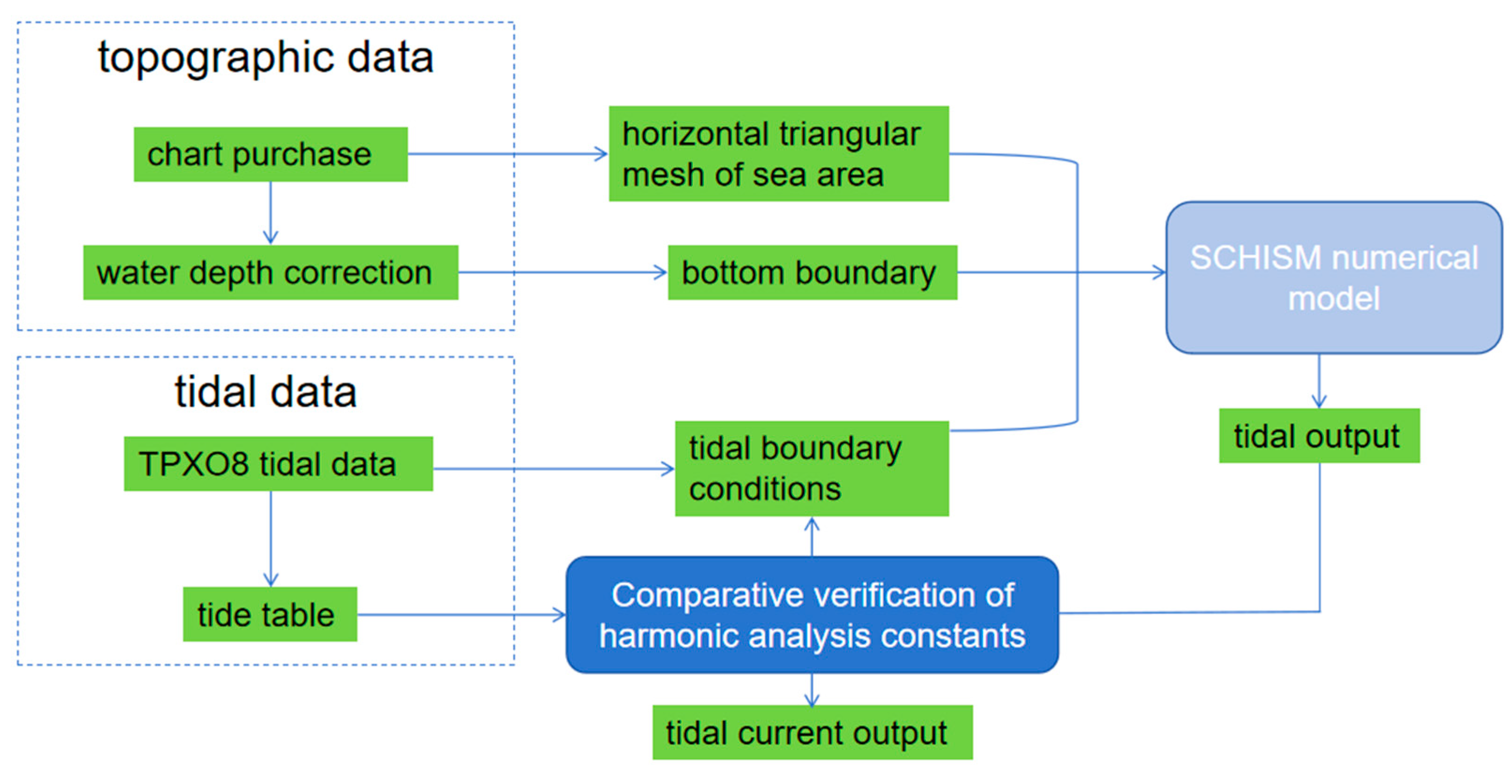
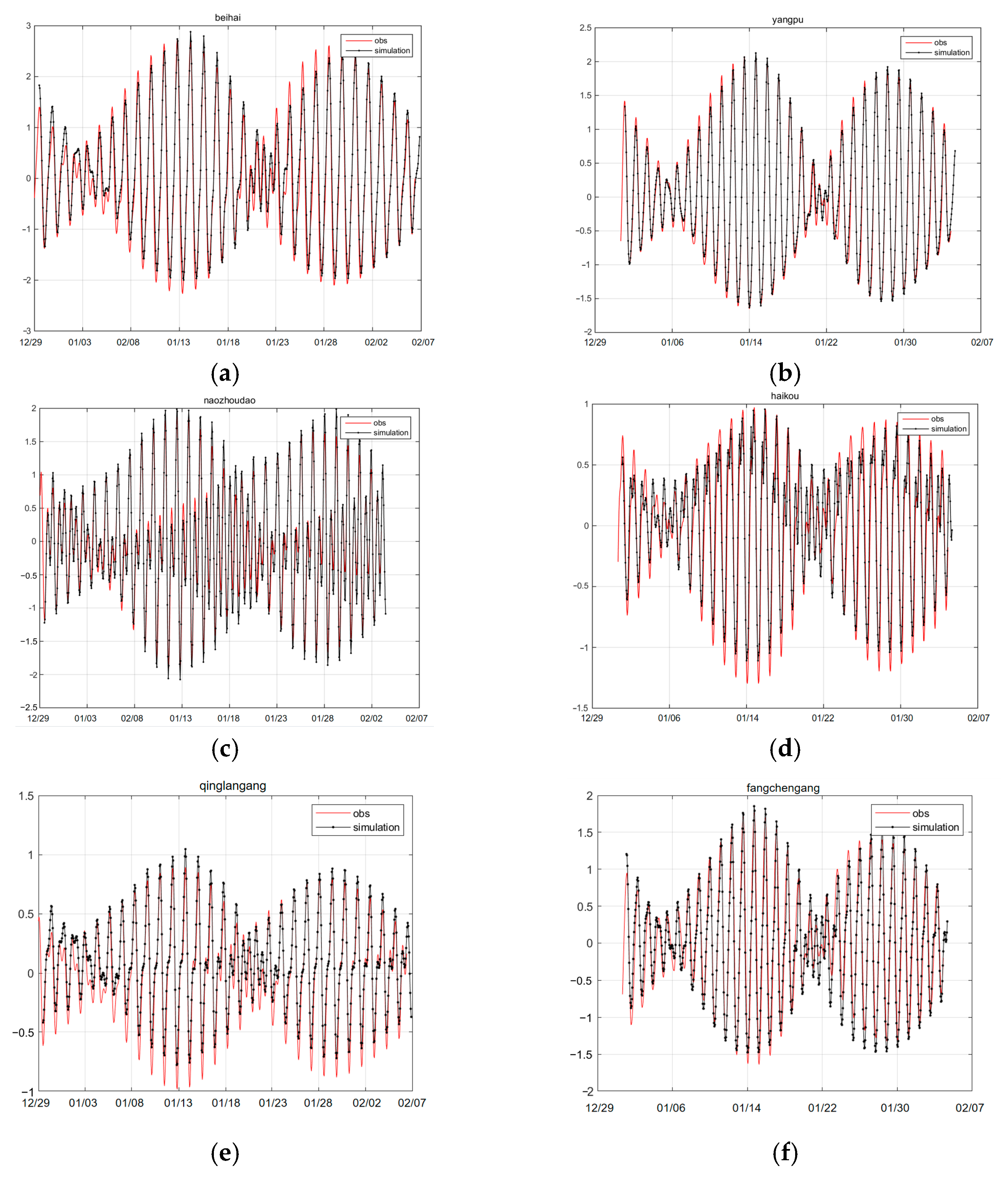
2.1. SCHISM Numerical Mode Settings

This study uses the Semi-implicit Cross-scale Hydroscience Integrated System Model (SCHISM, http://ccrm.vims.edu/schismweb/, accessed on 24 April 2025, [36,37]) to numerically simulate three-dimensional tidal currents in the Qiongzhou Strait and adjacent seas (105–113° E, 16–22° N). SCHISM employs a semi-implicit finite element/finite volume method for high efficiency and accuracy and uses an Eulerian–Lagrangian approach to solve the Navier–Stokes equations. The SCHISM model offers several unique features [36]: (1) Use of unstructured hybrid triangular/quadrilateral grids with optional SZ coordinates; (2) A high-order implicit transport scheme (TVD2) that ensures mass conservation and monotonicity; (3) A new momentum equation scheme with optional high-order Kriging and adaptive dissipation filters; (4) New horizontal viscosity schemes, including biharmonic viscosity, to filter spurious inertial modes without excessive dissipation; (5) High tolerance for grid quality in non-tidal areas.
In this study, the system is driven by the altimeter-assimilated TPXO8 tidal model [38] as tidal boundary conditions and validated using the water levels from surrounding tide stations to confirm the model’s tidal level (as shown in Figure 1). Bathymetry is derived from SRTM15+ (5 arc-second resolution [39]) and Chinese nautical charts [40]. The mesh has 49,221 nodes and 91,827 elements, and the resolution varies from 200 m in the Qiongzhou Strait to 15 km at the open boundary. The model uses 40 vertical layers: 20 sigma layers for depths ≤ 40 m and z-levels (5–200 m thick) for depths of 40–2200 m. The simulation domain is shown in Figure 2.
The time series of tide elevation at six tide gauge stations (location shown in Figure 2) near the Qiongzhou Strait were used to validate the tide simulation. The root mean squared error (RMSE) between observation and simulation time series, and the relative RMSE, the ratio between RMSE and maximum tidal range over the simulation period, are listed in Table 1. Figure 3 illustrates the simulated tidal level time series for January 2020 at 6 tide gauge stations—Beihai, Yangpu, Naozhoudao, Haiko, Qinglangang, and Fangchengang—which exhibit a high degree of consistency with the observed data (Table 1). Tidal elevation validation for the model has also been presented in detail in the studies of Tong et al. [31,41]. This validation demonstrates that the grids and settings of SCHISM, as adopted in this study, are effective at simulating changes in tidal elevation and currents. This validation also prepares for the reconstruction of a high spatiotemporal resolution three-dimensional flow field.
To simulate the wind-driven circulation in the Qiongzhou Strait under varying monsoon conditions, this study utilized the fifth-generation atmospheric reanalysis dataset ERA5, published by the European Centre for Medium-Range Weather Forecasts (ECMWF) [42], establishing wind stress boundary conditions based on this dataset. The dataset provides comprehensive hourly estimates of various climatic variables, including atmospheric, terrestrial, and oceanic parameters, with a spatial resolution of 0.25 degree. To achieve the aims of this study, data on sea surface wind speed components (u10, v10, Figure 4), atmospheric temperature, relative humidity, and sea surface pressure for the period between 1980 and 2023 were downloaded, focusing specifically on the Qiongzhou Strait and adjacent seas. Furthermore, to better capture and analyze the long-term effects of monsoon changes on the circulation in the Qiongzhou Strait, ERA5 data from February and August were used for winter and summer monsoons in the simulations.
This study utilizes vertical profiles of velocity from HYCOM [43,44] to establish velocity boundary conditions for the SCHISM model. HYCOM daily datasets cover the periods from 1 February 2020 to 29 February 2020 and from 1 August 2020 to 30 August 2020, including a range of data types, such as longitude, latitude, horizontal flow, and vertical flow. The latitude and longitude of the study area range from 0° N to 30° N and from 100° E to 123° E, with a horizontal resolution of 0.08° × 0.08°. The dataset divides water depth into 40 layers, unevenly distributed from the sea surface (0 m) to the sea floor (5000 m). The final data used include layers 0–40 and the 0–5000 m depth range. The velocity data were interpolated to layer depth for all the open boundary nodes.

2.2. Calculation of Bedload Sediment Transport

The following parameters, required for bedload sediment transport calculation, as outlined by the following formula, include the water depth of the study area, sediment grain size parameters, and current velocity. The surface sediment grainsize data are primarily derived from the sediment samples from the seabed surface, collected in the study area in 2008 and 2015, covering 249 sampling stations with an approximate interval of 5 km. After processing, samples smaller than 2 mm were analyzed using a Mastersizer 2000 laser particle size analyzer (Malvern Panalytical, Malvern, UK), while those larger than 2 mm were analyzed using sieving methods. The analysis was normalized to produce a comprehensive grain size distribution. Grain size parameters refer to a set of metrics used to characterize the distribution of sediment particle sizes, including mean size, standard deviation, skewness, and kurtosis. The particle size parameters can be derived by calculating sediment grain size using the graphical method proposed by Folk and Ward [45], and the classification and nomenclature of sediment types follow the Folk triangular classification system. This is illustrated in Figure 5.
Previous work has shown that the sediments at the eastern entrance of the Qiongzhou Strait are mainly bedload [46,47,48]. Bedload sediment transport rate uses Hardisity formula [49]:
q b = k 1 U 100 2 U 100 c r 2 U 100
where k 1 is a coefficient which is a function of sediment grain size, kg·s2/m4; q b is the bedload transport rate, kg/(m·s); U 100 is the velocity vector at 1 m from the bottom, m/s; U 100 c r is the critical incipient velocity at 1 m from the bottom, m/s. U 100 can be obtained from interpolation of the u and v. U 100 c r is a function of sedimentary granularity, and its expression is as follows [50,51]:
U 100 c r = 122.6 d 50 0.29 ,   d 50 < 0.2   cm
where d 50 is the sediment median particle size, cm.
k 1 is a function related to sediment grain size, and its expression is as follows [52]:
k 1 = 0.10 exp 0.17 d 50   , d 50 > 0.2 mm
k 1 = 1 8.9 d 50 0.42   , d 50 < 0.2 mm

3. Results

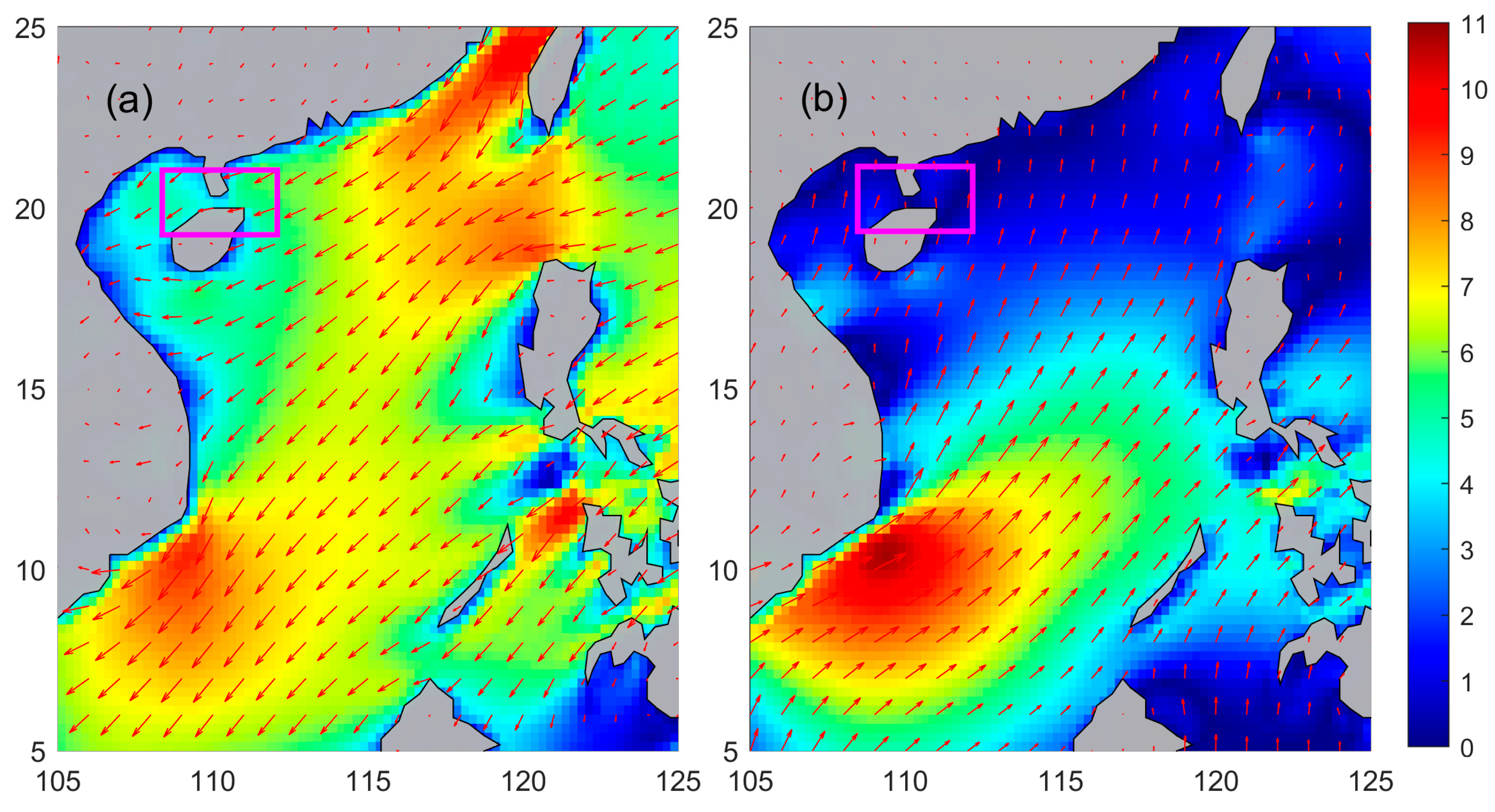
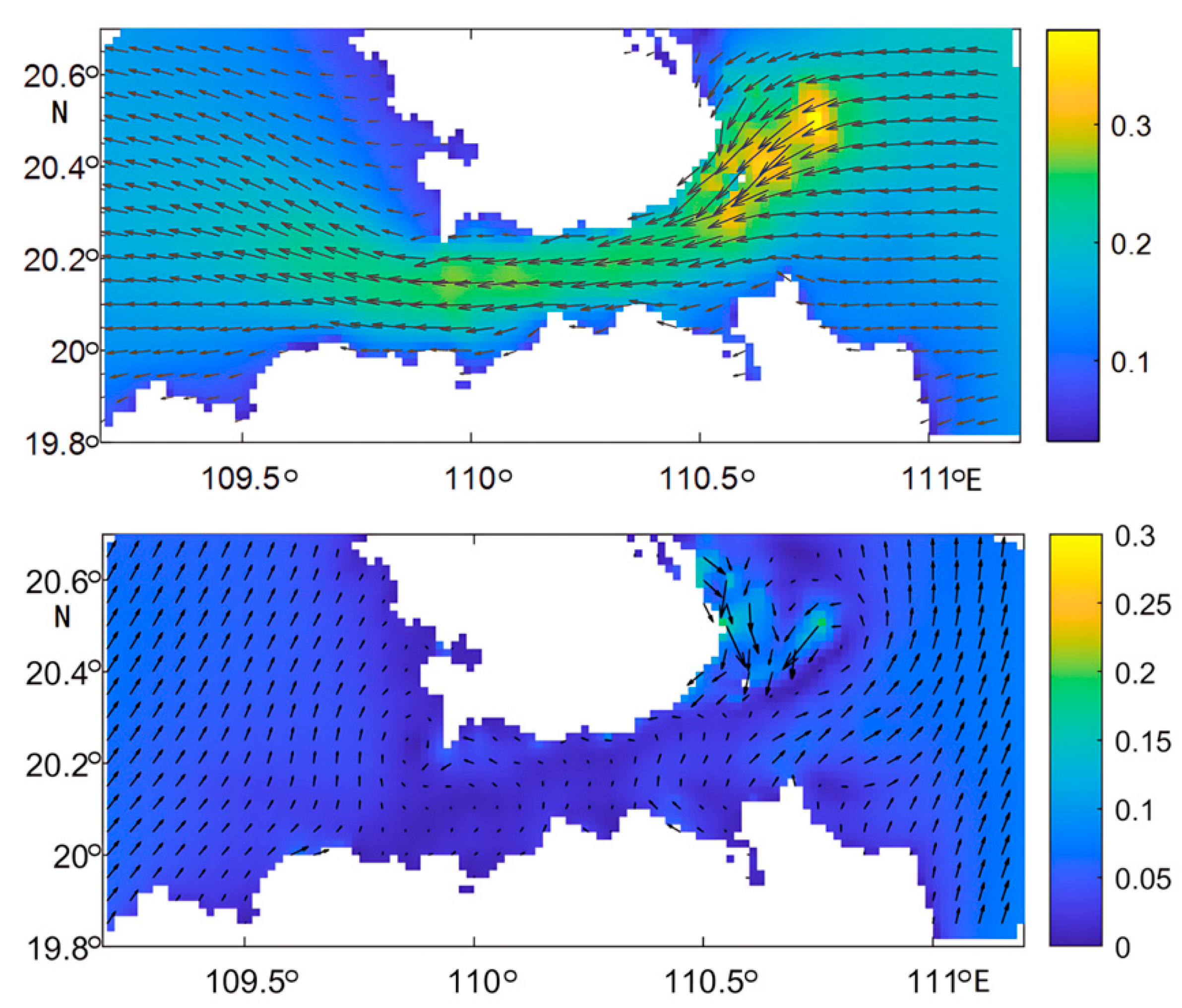
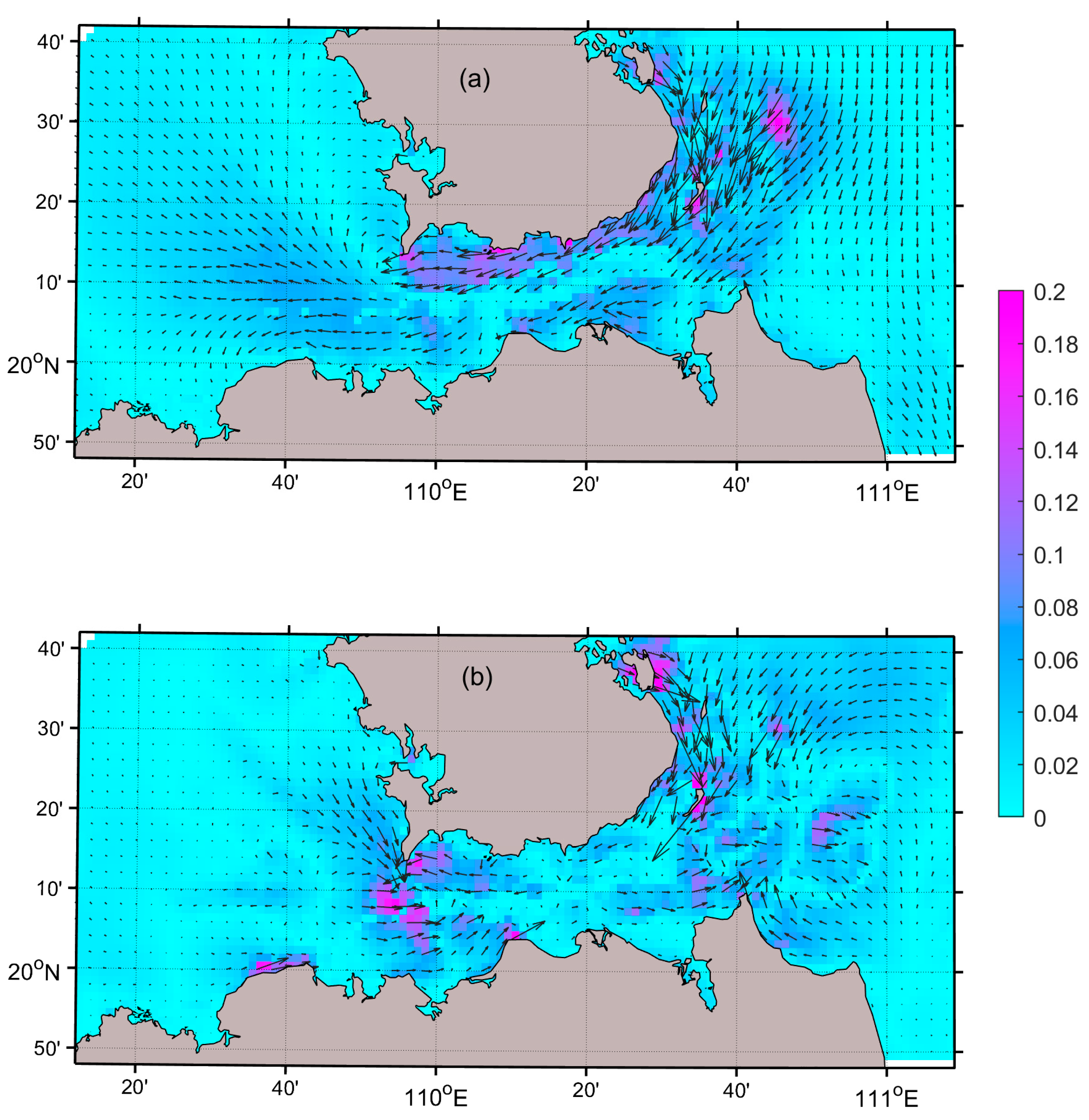
3.1. Monsoon Circulation in the Waters Surrounding the Qiongzhou Strait

Residual currents, defined as the components of ocean currents after removing periodic tidal flows, characterize the net transport intensity of materials in the ocean and are closely linked to sediment transport [53]. In this study, we conducted simulations utilizing tide-only forcing and both tidal and monsoonal forcing. A smoothing technique (25 h moving average) was applied to the data time series to remove the periodic tidal flows. This smoothing process also revealed tide-induced residual flows, which are a consequence of the Stokes drift of tidal waves and interactions with the topography. To accurately capture the wind-driven circulation, we meticulously subtracted these tide-induced residual flows, thereby obtaining a refined dataset that represents the circulation driven purely by wind dynamics. Month-long winter and summer flow field simulations reveal that the circulation structure in the waters surrounding the Qiongzhou Strait is strongly influenced by the northeast monsoon. The study area spans latitudes from 19.8° N to 20.7° N and longitudes from 109.19° E to 111.2° E.
The surface current velocity in the Qiongzhou Strait demonstrates substantial seasonal variability during the winter monsoon, with the northern region experiencing the most pronounced effects. Maximum velocities in this area can reach 38.0 cm/s, with a dominant northeast-to-southwest flow direction. This is illustrated in Figure 6. The intensified hydrodynamic conditions, driven by strong winds, enhance sediment suspension and long-range transport capacity in high-flow zones. This accelerated sediment transport, including potential resuspension, facilitates the displacement of sediments from their original locations. Consequently, high-velocity areas, particularly in the north, function as sediment transport pathways, while low-velocity zones serve as depositional environments. Moreover, the winter monsoon flow field in the Qiongzhou Strait is characterized by a reduced presence of vortex structures, exhibiting a more unidirectional flow pattern and significant regional velocity gradients. Despite the high flow intensity, the local vortex effect is minimal, thereby diminishing the influence of water flow circulation on sediment dynamics.
In contrast, the Qiongzhou Strait experiences reduced current velocities during the summer monsoon, characterized by generally lower surface velocities. This is illustrated in Figure 6. The maximum observed velocity is approximately 35.6 cm/s, and the current field exhibits a uniform distribution. The diminished wind forcing provides insufficient momentum transfer to the water column, resulting in lower velocities compared to the winter season. This reduction in current velocity diminishes the resuspension and long-distance transport capacity of sediments. Furthermore, during the summer monsoon, the Qiongzhou Strait exhibits the formation of vortex structures in localized regions, particularly in the central and southern areas, leading to a reduction in local current velocity.
The following table (Table 2) presents findings from previous research [46,54,55,56,57,58]. The simulation results of wind-driven circulation were indirectly validated by comparing them with the monsoon circulations observed or modeled in previous studies. Our simulation results are in agreement with the majority of previous studies in terms of residual flow direction and magnitude, taking into account certain inter-annual variations.
Figure 7 illustrates the monsoon-driven near-bottom circulation patterns. The U100 velocity field associated with residual circulation exhibits pronounced seasonal variations between winter and summer monsoon regimes. Notably, winter monsoon conditions exert the most substantial influence (up to 0.2 m/s), particularly in shallow regions near the eastern entrance and along the northern strait section. The residual flow demonstrates distinct spatial characteristics during this season, manifesting as southwestward currents in the northern sector of the eastern entrance and persistent westward transport within the strait. In contrast, summer monsoon conditions establish contrasting circulation patterns. Enhanced southward flow develops at the eastern entrance, while a southeastward current regime dominates the northern portion of the western entrance. Notably, the central strait region shows minimal monsoon-induced circulation variability during this season, suggesting reduced dynamic coupling between surface monsoon forcing and sub-surface currents in these areas.

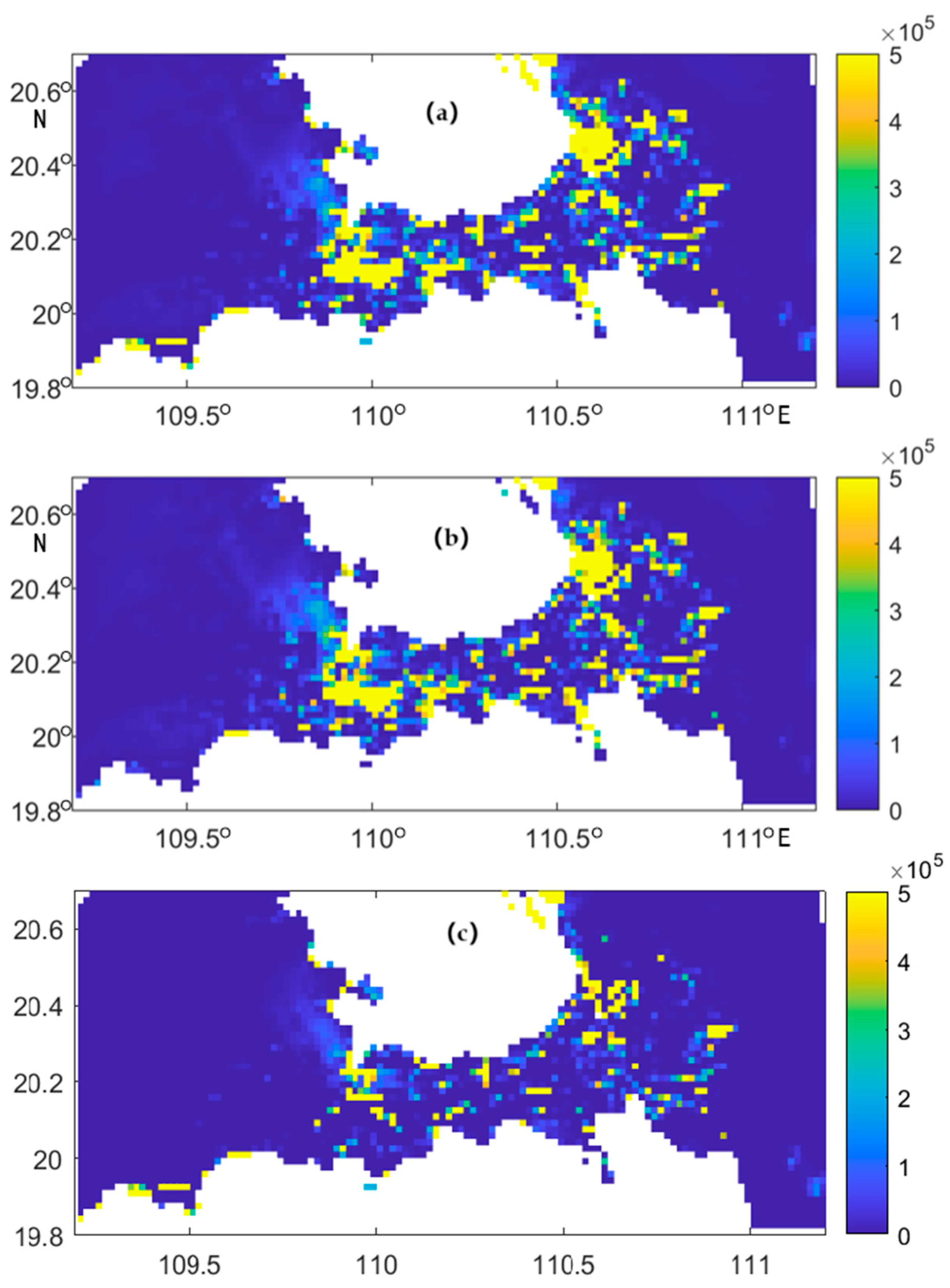
3.2. Net Sediment Transport per Unit Width

Through orthogonal decomposition and temporal integration of the suspended sediment transport rate during tidal cycles, this study has determined the net transport integrated over a month.
Driven by the winter monsoon, the Qiongzhou Strait experiences intensified currents and elevated flow velocities, particularly in the northern sector, resulting in a marked increase in net sediment transport. Analysis of Figure 8 reveals that the northern and central zones exhibit higher net monthly sediment transport, which are strongly correlated with the prevailing flow velocities and hydrodynamic conditions. The sediment transport rate in this area is notably large, ranging from 1 × 10⁵ to 2 × 10⁵ kg/m, suggesting large sediment transport activity. The robust currents induced by the winter monsoon facilitate the rapid resuspension and transport of sediments to distal locations. Conversely, in the marginal regions of the strait, where flow velocities are diminished, sediment accumulation is more pronounced. The reduction in flow velocity promotes sediment retention and deposition. Consequently, sediment transport under the winter monsoon displays a widespread pattern, predominantly concentrated in the northern and central regions, characterized by higher flow velocities.
In contrast, the Qiongzhou Strait experiences reduced flow velocities and more stable currents under the influence of the summer monsoon, with a more dispersed flow direction. Figure 8 indicates that the distribution of net sediment transport under the summer monsoon is more concentrated, primarily in the central and southern regions of the strait. These areas exhibit higher net sediment transport rates, and sediments are more likely to deposit in these regions as the flow velocity decreases. Relatively, the northern and lateral regions, which experience higher flow velocities, exhibit lower net sediment transport, indicating that the deceleration of flow inhibits the resuspension and long-distance transport of sediments in these areas.

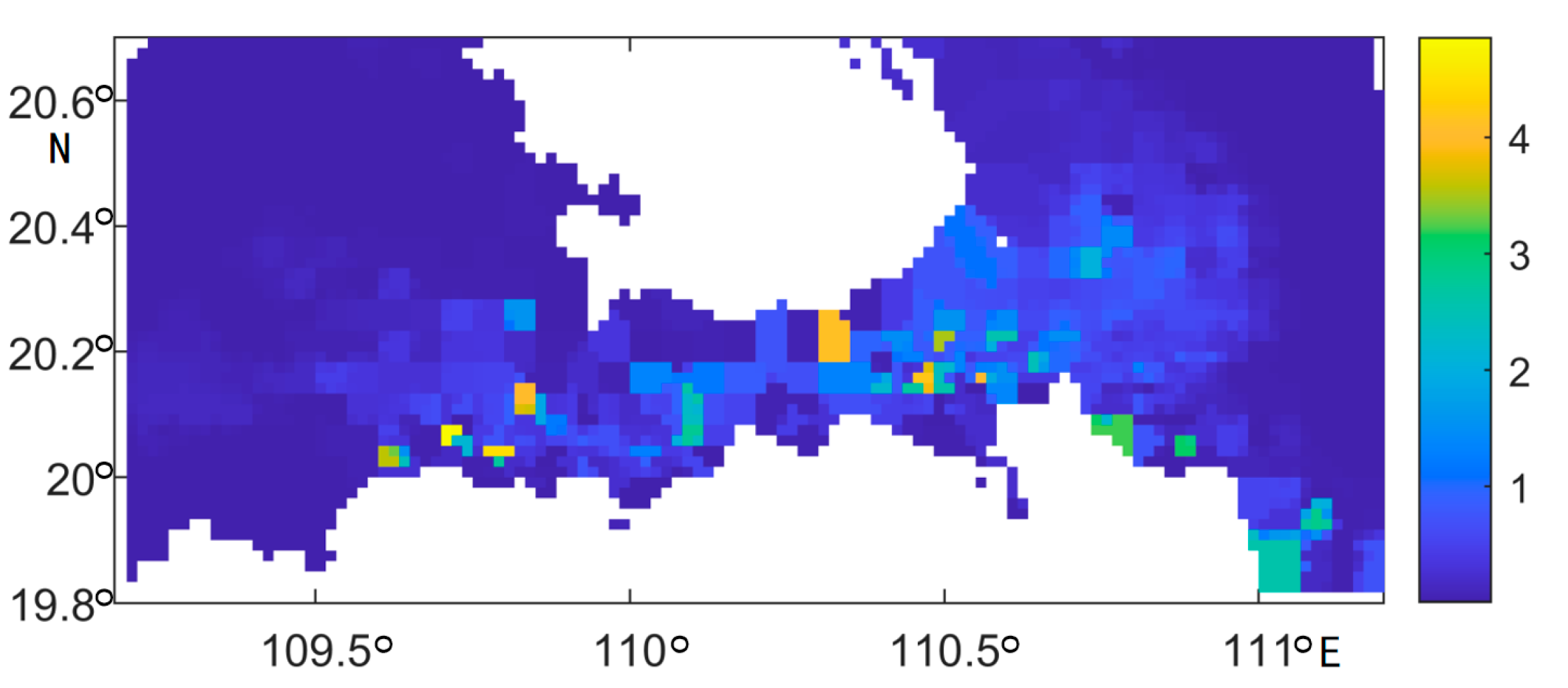
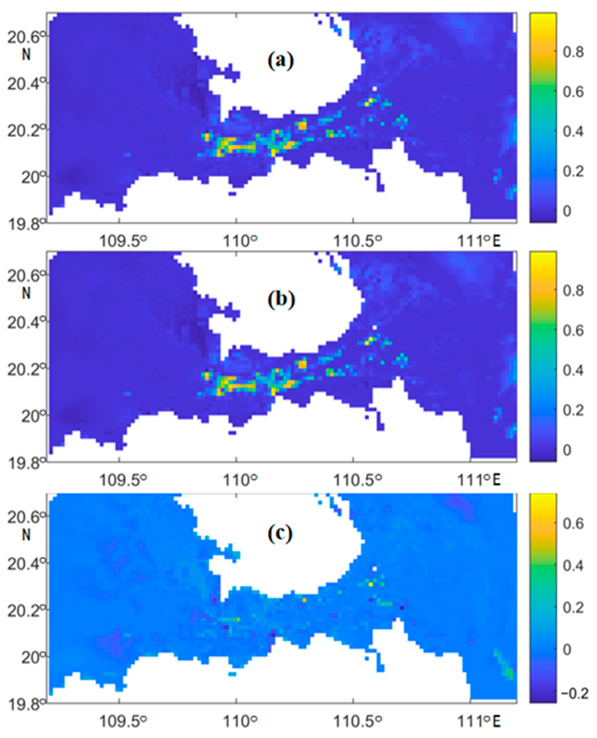
3.3. Analysis of Sediment Mobility

The duration of sediment mobility, defined as the length of time or fraction during which seabed sediments remain in motion, serves as a critical indicator for assessing sediment dynamics. We compared the fraction of seabed sediment mobility time by tide- and monsoon-driven circulation with that by tide current only. The total current including periodic tides was used to calculate seabed sediment mobility. The fraction changes are presented in Figure 9.
The central region of the strait demonstrates prolonged sediment transport durations during the winter monsoon season, attributed to elevated current intensity and flow velocities. These hydrodynamic conditions enhance sediment resuspension, redistribution, and sustained suspension, aligning with intensified monsoon-driven flow dynamics. Monsoon-induced transport durations significantly exceed those from tidal forces alone, particularly in central and constricted zones, where sustained high flows dominate over short-term tidal fluctuations. In contrast, reduced flow velocities along the strait’s flanks shorten sediment resuspension periods, promoting deposition. Comparatively, the central region exhibits higher hydrodynamic activity, characterized by enhanced sediment suspension capacity and extended transport times, underscoring its dynamic dominance under monsoon forcing.
Figure 9 demonstrates an elevated proportion of sediment transport duration in the central strait, as evidenced by the distribution of yellow regions. This observation implies that the summer monsoon induces extended periods of sediment motion within this area. The monsoon’s influence results in relatively stable and diminished flow velocities. The localized deceleration of the flow field promotes sediment retention and resuspension within the water column, thereby prolonging the duration of sediment transport. Compared to scenarios dominated by tidal forces, the summer monsoon significantly increases sediment transport duration. The reduced flow velocities associated with the summer monsoon provide extended residence times for sediments, thereby increasing the duration of sediment movement.
The literature indicates that sediment transport significantly impacts the stability of sandy seabeds [6]. By analyzing the provided figures, this study infers seasonal differences in the influence of winter and summer monsoons on the proportion of time during which seabed sediments are mobile. The winter monsoon has a broader and more pronounced effect, while the impact of the summer monsoon is more limited and less significant. This discrepancy may be due to differences in wind direction, speed, and duration between the two monsoons. The winter monsoon, characterized by higher wind speeds and longer durations, likely causes significant variations in the fraction of time that sediments are mobile. Conversely, the summer monsoon, with its variable wind direction, results in a more complex distribution of sediment mobility time fraction.

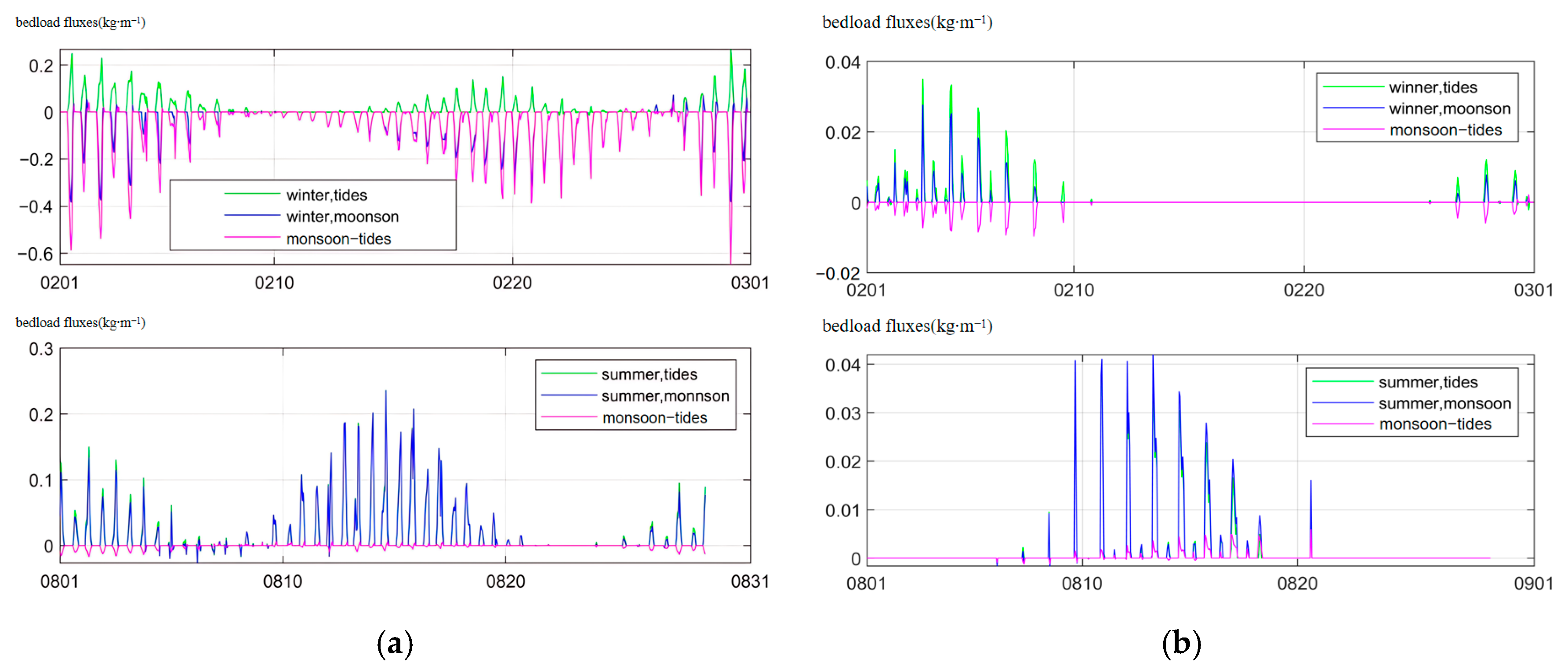
3.4. Time-Series of Bedload Transport Rate

Sediment transport dynamics at the eastern (Point B) and western (Point A) entrances of the strait (Figure 10) were investigated to assess the influences of monsoon and tidal forces. Numerical simulations integrating both monsoon-driven circulation and tidal currents were conducted, with the isolated contribution of monsoonal circulation determined by subtracting tidal-only time series. Time-series analysis (Figure 11) reveals periodic sediment transport fluctuations driven by the interplay of monsoon and tidal effects, with the monsoon’s east-to-west flow exerting spatially variable impacts.
At the eastern entrance, tidal forces drive eastward bedload transport at rates of 0.01–0.03 kg/(m·s) during winter spring tides, while monsoon-induced transport is an order of magnitude lower (~0.01 kg/(m·s)) and directionally opposed. Summer tide-induced transport is significantly reduced, though monsoon-driven transport remains comparably weaker and directionally consistent.
At the western entrance, winter tidal transport is approximately five times that of the eastern rate, while monsoon-induced transport far exceeds the magnitude at the east entrance, it opposes the tidal direction. Summer tidal transport is approximately half of the winter levels, with monsoon-driven transport aligning with the eastern entrance. And the magnitude is about threefold that of the eastern entrance.
Tide-induced transport at the western entrance is 3–4 times greater than at the eastern entrance. Monsoon influence exhibits seasonal and spatial variability: winter monsoon effects are more pronounced at the western entrance, while summer monsoon-driven transport is weaker across the study area. These findings underscore the complex spatiotemporal interactions between tidal and monsoonal forces in shaping sediment transport dynamics.

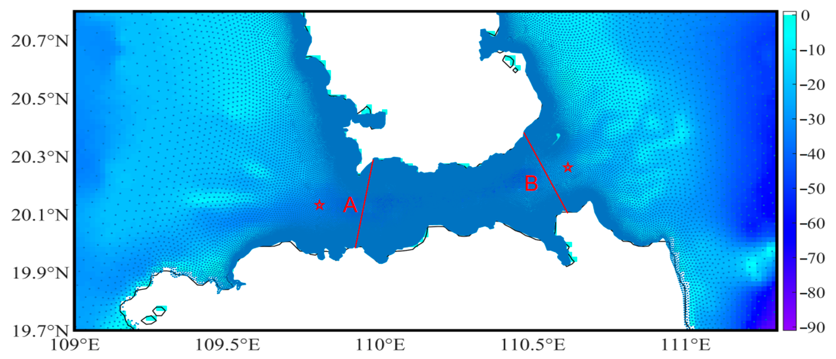
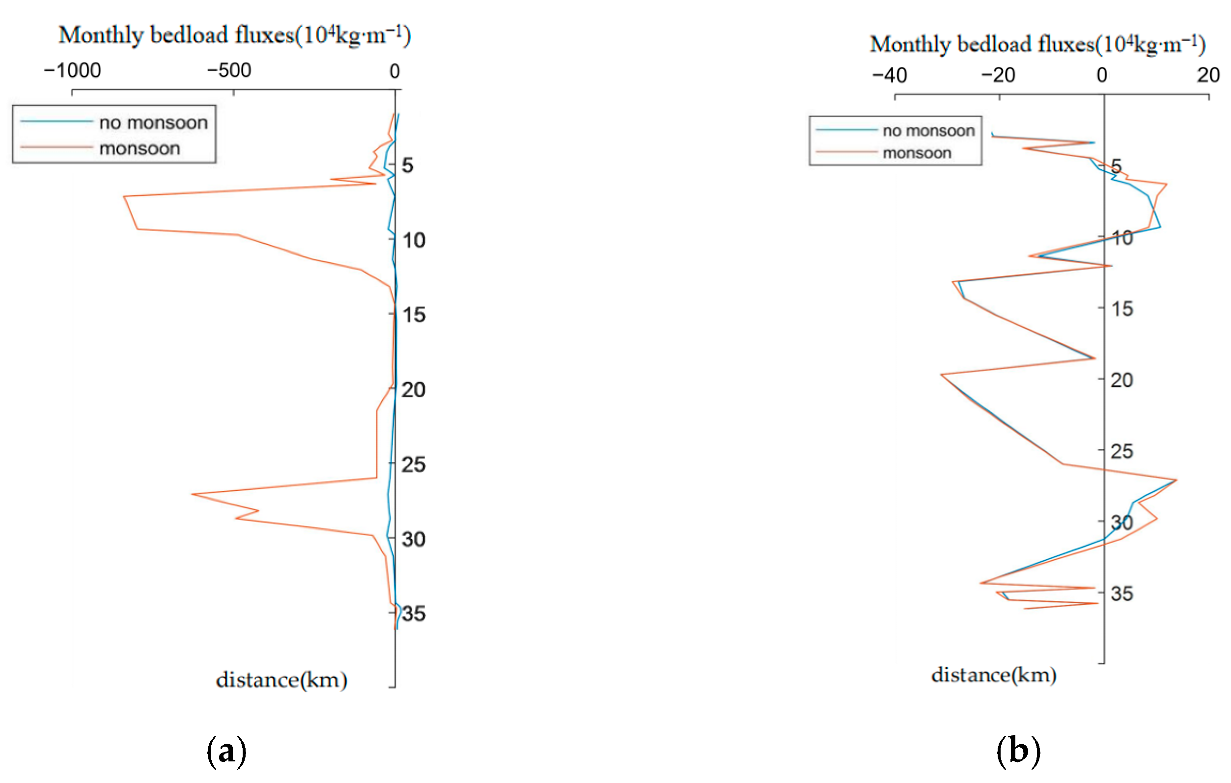
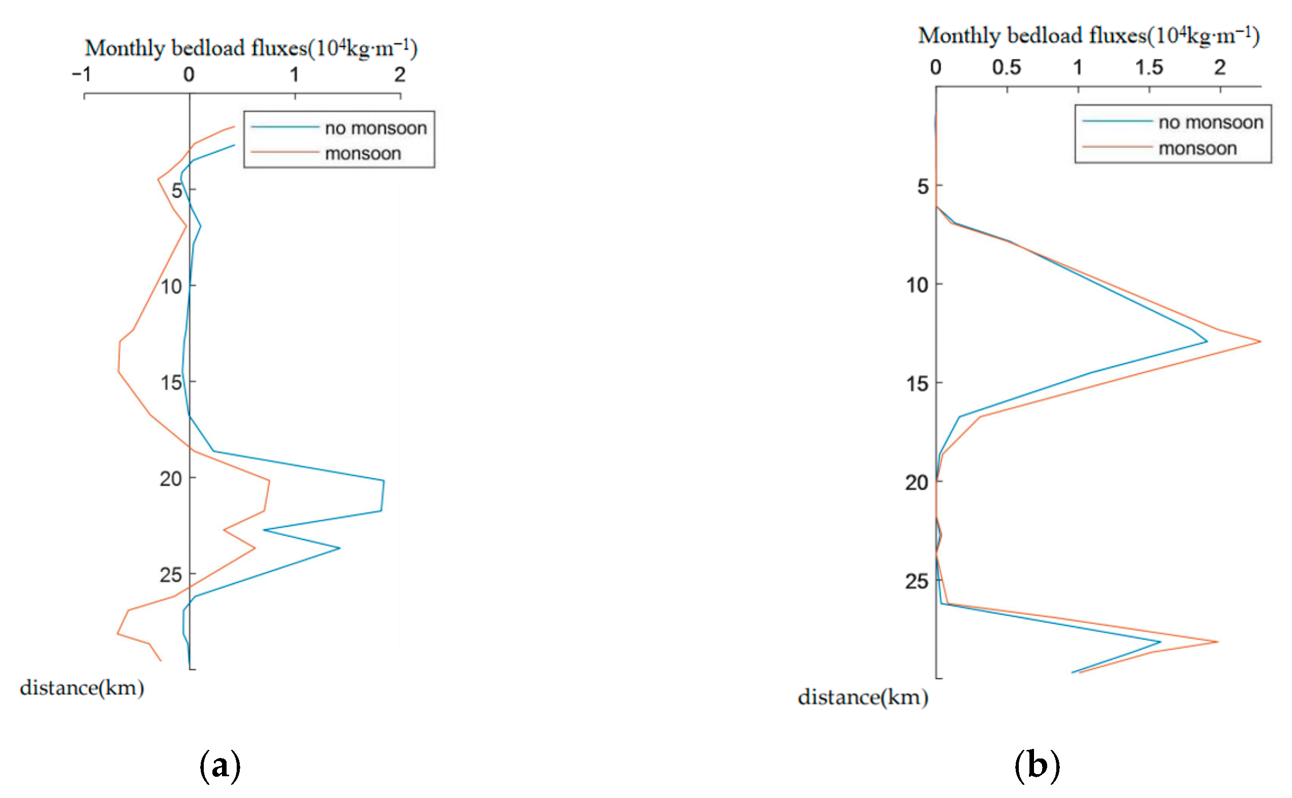
3.5. Bedload Transport Across Sections in the Qiongzhou Strait

We calculated the monthly unit-width net sediment transport by synthesizing daily averages and integrating them over each month. To investigate contrasting sediment dynamics between the western and eastern entrances of Qiongzhou Strait, two stars, representative of cross-sections (A and B) were strategically established, one at each entrance (Figure 9), capturing distinct hydrodynamic regimes shaped by monsoonal forcing and local bathymetry. Figure 12 and Figure 13 present the monthly unit-width sediment transport along these transects, revealing pronounced spatial–temporal patterns driven by monsoons over the integrated monthly scale.
At the eastern entrance, summer southwest winds drive a west-to-east current, facilitating eastward sediment transport. During the monsoon period, the transport rate is significantly higher (0 to 20,000 kg/m) than during non-monsoon conditions. In contrast, winter northeast winds reverse the flow direction to westward, reducing the transport rate to 0 to 10,000 kg/m. These findings highlight the seasonal impact of the monsoon on sediment transport at this entrance.
The western entrance exhibits more complex dynamics. Winter northeast winds cause east-to-west flow, leading to westward sediment transport. Under monsoon conditions, certain areas experience transport maxima up to 8,000,000 kg/m. The monthly per unit width transport at the western entrance generally exceeds that at the eastern entrance, indicating a stronger monsoonal influence, likely due to the area’s open topography.
In summary, the monsoon significantly influences sediment transport in the Qiongzhou Strait, with marked seasonal variations. The eastward transport in summer contrasts with the westward transport in winter, reflecting the distinct hydrodynamic and topographical conditions at each entrance.

4. Discussion

4.1. Impact of Monsoon Circulation on the Transport of Sediment

Simulations using the SCHISM model demonstrate that the winter northeast monsoon significantly enhances flows in the northern Qiongzhou Strait, averaging 16.2 cm/s and peaking at 38.0 cm/s, thereby promoting long-distance sediment transport. These results align with Tong et al. [32,41], who also emphasized the monsoon’s role in sediment transport through field observations and numerical simulations. The intensified winter northeast monsoon drives stronger flows, confirming its importance in long-distance sediment transport. In contrast, the summer southwest monsoon leads to localized sediment accumulation, as evidenced by complex circulation patterns and uneven velocity distributions. Maximum velocities reach 35.62 cm/s, with vortex structures forming in the central and southern strait, potentially trapping sediment in specific areas while enhancing transport in higher-velocity regions.
In regions experiencing seasonal atmospheric forcing, the influence of the monsoon on sediment transport has been documented in several locations, including the Bay of Bengal [59], the Gulf of Thailand, the Sunda Shelf [60], and the northwestern continental shelf of the South China Sea [29]. This impact is not solely attributed to monsoon-driven circulations but also extends to the wind–wave climate [30] and the supply of sediment [61,62].

4.2. Sediment Supplies

Sediment supply is critical to monsoon-driven transport capacity. While this study highlights the monsoon’s significant transport potential, the availability of sufficient sediment remains uncertain. Future research should focus on (1) assessing sediment supply through field surveys and historical data; (2) investigating monsoon-driven sediment initiation, suspension, and settling mechanisms; and (3) analyzing long-term sediment records, such as sediment cores, to understand historical monsoon impacts.

4.3. Global Change Context and Future Projections

Projected monsoon changes under climate change—weakening winter intensities [63] and enhanced summer patterns [64]—may critically alter sediment dynamics in Qiongzhou Strait. Key thresholds identified include the following:
Winter transport attenuation: A 15% reduction in wind speed could decrease westward sediment flux along the northern strait axis by 40%, elevating erosion risks along the Leizhou Peninsula.
Summer phase shift: Intensified southwestern monsoons may amplify hydrodynamic cancellation, reducing central strait net transport by 78% while promoting eastern shelf deposition (>2.3 mm/yr).
Increased typhoon intensity (+24%, [65]) could dominate episodic sediment redistribution (5.7 × 10⁶ t/event), with amplified impacts under high-emission scenarios [66]. This necessitates resilient coastal engineering designs with ≥15° bedload transport directional tolerance.

4.4. Implications for Regional Marine Environmental Management

The seasonal variability of monsoon impacts on sediment transport has important implications for regional marine management and coastal protection. The winter northeast monsoons increase flows, potentially exacerbating coastal erosion and facilitating long-distance transport, necessitating enhanced monitoring and protective measures. Summer southwest monsoons, with their complex circulation and localized sediment accumulation, may affect marine ecosystems, such as coral reefs and fisheries, requiring targeted assessments. Consider the wave climate during different seasons. For instance, winter storms can lead to increased sediment transport rates compared to calmer summer conditions. Designs should be robust enough to withstand the highest expected sediment transport rates.
Additionally, sediment transport influenced by monsoons impacts marine engineering structures, including ports, navigation channels, wind farms, and subsea cables. Incorporating monsoon effects into the design and construction phases is essential for project safety and durability. Moreover, interdisciplinary research integrating oceanography, geology, and ecology is recommended to better predict and manage monsoon impacts on the marine environment.

5. Conclusions

This study quantitatively evaluates monsoon-driven bedload sediment transport dynamics in the Qiongzhou Strait through SCHISM modeling, revealing three principal findings:
(1)
Monsoon seasonality controls net sediment flux through contrasting hydrodynamic regimes: the winter monsoon establishes spatially coherent westward transport pathways, while the summer monsoon induces mutually opposing flows that might suppress net transport.
(2)
Tidal and monsoon forcing exhibit counteractive transport vectors at both eastern and western strait entrances during winter, with monsoon-driven bedload transport dominating the western entrance while tidal forcing prevails in the eastern sector.
(3)
The summer monsoon influences show reduced hydrodynamic coupling, generating merely 10% or less of the tidal transport magnitude across critical cross-sections.
These findings advance understanding of sediment budget partitioning in monsoon-dominated shelf seas, particularly elucidating the spatial heterogeneity of tidal vs. meteorological forcing. The modeled reversal of dominant transport mechanisms between eastern and western gateways provides mechanistic explanation for observed asymmetries in sedimentary architecture.
Methodological constraints warrant consideration in interpreting results. While ERA5 wind forcing provides robust first-order approximations, the spatial interpolation protocol likely underestimates localized wind stress extremes by 15–20% based on comparative validation studies.
Future investigations should prioritize the following:
  • Implementation of dynamic downscaling techniques to resolve subgrid-scale atmospheric–oceanic interactions;
  • Implementation of multi-physics coupled modeling frameworks integrating wave–current–tide interactions to quantify their synergistic effects on sediment transport partitioning;
  • Climate projection experiments quantifying sediment flux sensitivity to IPCC SSP scenarios.

Author Contributions

Conceptualization, X.W.; methodology, Y.H.; validation, C.T.; formal analysis, H.M.; investigation, X.L.; resources, S.Z.; data curation, Y.H.; writing—original draft preparation, Y.H. and X.W.; writing—review and editing, Y.H. and X.W.; funding acquisition, S.Z. All authors have read and agreed to the published version of the manuscript.

Funding

This research was funded by the Hainan Provincial Natural Science Foundation, China (No. 422RC800) and National Natural Science Foundation of China (No. 42076005).

Data Availability Statement

Data used in this paper have been uploaded to the Science Data Bank (https://www.scidb.cn/en, accessed on 24 April 2025) and can be accessed via this link: https://www.scidb.cn/en/anonymous/VmpJbm1l (accessed on 24 April 2025), or DOI:10.57760/sciencedb.20482.

Conflicts of Interest

The authors declare no conflicts of interest.

References

  1. Xu, X.; Cao, Z.; Zhang, Z.; Wang, Z. The type and distribution pattern of geomorphology in the Bohai sea. Mar. Geol. Quat. Geol. 2014, 6, 171–179. [Google Scholar]
  2. Dyer, K.R.; Huntley, D.A. The origin, classification and modelling of sand banks and ridges. Cont. Shelf Res. 1999, 19, 1285–1330. [Google Scholar] [CrossRef]
  3. Ouillon, S. Why and How Do We Study Sediment Transport? Focus on Coastal Zones and Ongoing Methods. Water 2018, 10, 390. [Google Scholar] [CrossRef]
  4. Liu, Z.; Tang, Y.; Wang, K.; Xia, D. Tidal Dynamic Geomorphic System in the East Part of the Bohai Sea. Oceanol. Limnol. Sin. 1996, 14, 7–21. [Google Scholar]
  5. Shi, M.; Chen, C.; Xu, Q.; Lin, H.; Liu, G.; Wang, H.; Wang, F.; Yan, J. The role of Qiongzhou Strait in the seasonal variation of the South China Sea circulation. J. Phys. Oceanogr. 2002, 32, 103–121. [Google Scholar] [CrossRef]
  6. Gao, S.; Fang, G.; Yu, K.; Jia, J. Methodology for evaluating the stability of sandy seabed controlled by sediment movement with an example of application. In Studia Marina Sinica; Springer: Berlin/Heidelberg, Germany, 2001; pp. 25–37. [Google Scholar]
  7. Ni, Y.; Endler, R.; Xia, Z.; Endler, M.; Harff, J.; Gan, H.; Schulz-Bull, D.E.; Waniek, J.J. The “butterfly delta” system of Qiongzhou Strait: Morphology, seismic stratigraphy and sedimentation. Mar. Geol. 2014, 355, 361–368. [Google Scholar] [CrossRef]
  8. Chen, S. Coastal dynamic geomorphological researches on south coast of Qiongzhou Strait. Trop. Oceanol. 1998, 3, 35–42. [Google Scholar]
  9. Jin, B.; Bao, C.; Lin, J. Geomorphic feature and origin of the deltas at the east and west mouthes of Qiongzhou Strait. Mar. Geol. Res. 1982, 4, 94–101. [Google Scholar]
  10. Ke, P. A preliminary analysis of currents and water exchanges in the Qiongzhou Strait. Trop. Oceanol. 1983, 1, 42–46. [Google Scholar]
  11. Ye, C. Distribution of sediments and submarine topography of Qiongzhou Strait. Trop. Geogr. 1986, 4, 346–353. [Google Scholar]
  12. Zheng, Q.; Wang, H.; Li, S.; Cao, Z.; Bao, M. Dynamics of currents in the Qiongzhou strait during spring and summer based on a numerical simulation. Front. Mar. Sci. 2024, 11, 1367145. [Google Scholar] [CrossRef]
  13. Cheng, H.; Li, J.; Yin, D.; Li, M.; Wang, B. Nearshore bedform instability in the eastern entrance to the Qiongzhou Strait, South China Sea. Front. Earth Sci. China 2008, 2, 283–291. [Google Scholar] [CrossRef]
  14. Li, Z.; Ke, X.; Wang, Q.; Gao, J. Characteristics of water and sedimenttransport in the Qiongzhou Strait. Geogr. Res. 2003, 2, 151–159. [Google Scholar]
  15. Xiao, X.; Shi, Y.; Feng, X.; Xu, Y. Surface Sediment Characteristics and Dynamics in Beibu Gulf. J. Ocean Univ. China 2016, 46, 151–159. [Google Scholar]
  16. Ma, X.; Li, J.; Yan, J. Tide-induced bedload transport pathways in a multiple-sand-ridge system offshore of Hainan Island in the Beibu Gulf, northwest South China Sea. Earth Surf. Process. Landf. 2018, 43, 2738–2753. [Google Scholar] [CrossRef]
  17. Cong, S.; Wu, X.; Ge, J.; Bi, N.; Li, Y.; Lu, J.; Wang, H. Impact of Typhoon Chan-hom on sediment dynamics and morphological changes on the East China Sea inner shelf. Mar. Geol. 2021, 440, 106578. [Google Scholar] [CrossRef]
  18. Wang, C.; Zhao, C.; Yang, G.; Li, C.; Zhu, J.; Ma, X. Response of Sediment Dynamics to Tropical Cyclones under Various Scenarios in the Jiangsu Coast. J. Mar. Sci. Eng. 2024, 12, 1053. [Google Scholar] [CrossRef]
  19. Bao, J.; Cai, F.; Wu, C.; Lu, H.; Zheng, Y.; Li, Y.; Sun, L.; Liu, C.; Li, Y. Regeneration and anti-migration of sand waves associated with sand mining in the Taiwan Shoal. Acta Oceanol. Sin. 2023, 42, 71–78. [Google Scholar] [CrossRef]
  20. Zhang, C. Characteristics of tidal current dynamic in Lianyungang nearshore area. Port Waterw. Eng. 2012, 9, 30–34. [Google Scholar]
  21. French, J.R.; Burningham, H.; Benson, T. Tidal and Meteorological Forcing of Suspended Sediment Flux in a Muddy Mesotidal Estuary. Estuaries Coasts 2008, 31, 843–859. [Google Scholar] [CrossRef]
  22. Bartholomä, A.; Kubicki, A.; Badewien, T.H.; Flemming, B.W. Suspended sediment transport in the German Wadden Sea—Seasonal variations and extreme events. Ocean Dyn. 2009, 59, 213–225. [Google Scholar] [CrossRef]
  23. Colosimo, I.; de Vet, P.L.M.; van Maren, D.S.; Reniers, A.J.H.M.; Winterwerp, J.C.; van Prooijen, B.C. The Impact of Wind on Flow and Sediment Transport over Intertidal Flats. J. Mar. Sci. Eng. 2020, 8, 910. [Google Scholar] [CrossRef]
  24. Li, F.; Griffiths, C.; Paraschivoiu, E.; Dyt, C.; Jenkins, C.; Rutherford, M.J. Wind-driven Water Circulation And Its Impact On Seabed Sediment Transport In the Australian Northeast. In Proceedings of the Seventh ISOPE Pacific/Asia Offshore Mechanics Symposium, Dalian, China, 17–21 September 2006. [Google Scholar]
  25. Andutta, F.P.; Patterson, R.G.; Wang, X.H. Monsoon driven waves superpose the effect from macro-tidal currents on sediment resuspension and distribution. Estuar. Coast. Shelf Sci. 2019, 223, 85–93. [Google Scholar] [CrossRef]
  26. Wang, A.; Ralston, D.K.; Bi, N.; Cheng, Z.; Wu, X.; Wang, H. Seasonal variation in sediment transport and deposition on a muddy clinoform in the Yellow Sea. Cont. Shelf Res. 2019, 179, 37–51. [Google Scholar] [CrossRef]
  27. Bi, N.; Yang, Z.; Wang, H.; Fan, D.; Sun, X.; Lei, K. Seasonal variation of suspended-sediment transport through the southern Bohai Strait. Estuar. Coast. Shelf Sci. 2011, 93, 239–247. [Google Scholar] [CrossRef]
  28. Zhu, D.; Li, L.; Li, Y.; Guo, X. Seasonal variation of surface currents in the southwestern Taiwan Strait observed with HF radar. Chin. Sci. Bull. 2008, 53, 2385–2391. [Google Scholar] [CrossRef]
  29. Wang, A.; Zhang, L.; Chen, X.; Liu, X.; Lang, H.; Xu, Z.; Xu, C.; Wang, X.; Xu, F. Distribution and bi-directional transport of surface sediments driven by monsoons on the northwest continental shelf of the South China Sea. Geo-Mar. Lett. 2025, 45, 1. [Google Scholar] [CrossRef]
  30. Chen, L.; Zhang, Y.; Li, T.; Yang, W.; Chen, J. Sedimentary Environment and Its Evolution of Qiongzhou Strait and Nearby Seas since Last Ten Thousand Years. Earth Sci.-J. China Univ. Geosci. 2014, 39, 696–704. [Google Scholar]
  31. Tong, C.; Zhu, Y.; Wu, X.; Mo, Y.; Wang, X. Estimation of Bedload Transport at the Eastern Entrance of the Qiongzhou Strait based on Numerical Simulation. Earth Sci. Front. 2023, 30, 553–566. [Google Scholar]
  32. Tong, C.; Chen, F.; Zhang, K. Analysis of the distribution and development of marine sand resources in the northeast sea of Hainan island. China Min. Maniz. 2019, 28, 58–65. [Google Scholar]
  33. Wu, C.; Cen, Z.; Cai, C.; Xu, Y. Analysis on the Sand Wave Stability of the Submarine Cable Route in the Qiongzhou Strait. Sci. Technol. Innov. Her. 2019, 16, 48–50. [Google Scholar]
  34. You, Q.; Jiang, Z.; Yue, X.; Guo, W.; Liu, Y.; Cao, J.; Li, W.; Wu, F.; Cai, Z.; Zhu, H.; et al. Recent frontiers of climate changes in East Asia at global warming of 1.5 °C and 2 °C. NPJ Clim. Atmos. Sci. 2022, 5, 80. [Google Scholar] [CrossRef]
  35. Li, Z.; Sun, Y.; Li, T.; Ding, Y.; Hu, T. Future changes in East Asian summer monsoon circulation and precipitation under 1.5 to 5 °C of warming. Earth’s Future 2019, 7, 1391–1406. [Google Scholar] [CrossRef]
  36. Zhang, Y.; Ye, F.; Stanev, E.V.; Grashorn, S. Seamless cross-scale modeling with SCHISM. Ocean Model. 2016, 102, 64–81. [Google Scholar] [CrossRef]
  37. Ye, F.; Zhang, Y.; Friedrichs, M.; Wang, H.V.; Irby, I.; Shen, J.; Wang, Z. A 3D, cross-scale, baroclinic model with implicit vertical transport for the Upper Chesapeake Bay and its tributaries. Ocean Model. 2016, 107, 82–96. [Google Scholar] [CrossRef]
  38. Egbert, G.D.; Erofeeva, S.Y. Efficient inverse modeling of barotropic ocean tides. J. Atmos. Ocean. Technol. 2002, 19, 183–204. [Google Scholar] [CrossRef]
  39. Tozer, B.; Sandwell, D.T.; Smith, W.H.F.; Olson, C.; Beale, J.R.; Wessel, P. Global bathymetry and topography at 15 arc sec: SRTM15+. Earth Space Sci. 2019, 6, 1847. [Google Scholar] [CrossRef]
  40. China Navy Hydrographic Office. Beibu Gulf (C1316020); China Navigation Press: Beijing, China, 2020. [Google Scholar]
  41. Tong, C.; Qin, M.; Wang, X.; Wu, X. Estimation of the Spring Tide Bedload Transport at the Eastern Entrance of the Qiongzhou Strait. Water 2023, 15, 724. [Google Scholar] [CrossRef]
  42. Hersbach, H.; Bell, B.; Berrisford, P.; Biavati, G.; Horányi, A.; Muñoz Sabater, J.; Nicolas, J.; Peubey, C.; Radu, R.; Rozum, I.; et al. ERA5 hourly data on single levels from 1940 to present. In Copernicus Climate Change Service (C3S) Climate Data Store (CDS); ECMWF: Bonn, Germany, 2023. [Google Scholar] [CrossRef]
  43. Halliwell, G.; Bleck, R.; Chassignet, E. Atlantic Ocean simulations performed using a new hybrid-coordinate ocean model. In EOS, Fall 1998 AGU Meeting; AGU Publications: Washington, DC, USA, 1998. [Google Scholar]
  44. Large, W.G.; Danabasoglu, G.; Doney, S.C.; McWilliams, J.C. Sensitivity to surface forcing and boundary layer mixing in a global ocean model: Annual-mean climatology. J. Phys. Oceanogr. 1997, 27, 2418–2447. [Google Scholar] [CrossRef]
  45. Folk, R.L.; Andrews, P.B.; Lewis, D. Detrital sedimentary rock classification and nomenclature for use in New Zealand. N. Z. J. Geol. Geophys. 1970, 13, 937–968. [Google Scholar] [CrossRef]
  46. Zhang, X.; Xu, J. Lagoon Inlet Hydraulic Characteristic and Transformation. Mar. Sci. Bull. 2006, 4, 57–62. [Google Scholar]
  47. Zeng, W.; Zhang, D.; Liu, B.; Yang, Y.; Zhang, H.; Wu, D. Grain size characteristics and transport trends of surface sediment in the bays of northern Hainan Island. Mar. Geol. Front. 2024, 40, 10–18. [Google Scholar]
  48. Chen, B.; Shi, M. Advances in Study of Beibu Gulf Circulation. Guangxi Sci. 2019, 26, 595–603. [Google Scholar]
  49. Hardisty, J. An assessment and calibration of formulations for Bagnold’s bedload equation. J. Sediment. Res. 1983, 53, 1007–1010. [Google Scholar] [CrossRef]
  50. Soulsby, R. Dynamics of Marine Sands; Thomas Telford Publications: London, UK, 1997; p. 205. [Google Scholar]
  51. Miller, M.; McCave, I.; Komar, P.D. Threshold of sediment motion under unidirectional currents. Sedimentology 1977, 24, 507–527. [Google Scholar] [CrossRef]
  52. Wang, Y.; Gao, S. Modification to the Hardisty equation, regarding the relationship between sediment transport rate and particle. J. Sediment. Res. 2001, 71, 118–121. [Google Scholar] [CrossRef]
  53. Fang, S.; Yu, F.H. Temporal and spatial variation characteristies of residual current and net flux during flood and dry season in inner Lingdingyang estuary. Port Waterw. Eng. 2023, 11, 8–14+22. [Google Scholar]
  54. Shi, M.; Chen, C.; Huang, F.; Ye, A. Characteristics of the Residual Current Field at the End of Winter and Beginning of Spring in the Qiongzhou Strait. Acta Oceanol. Sin. 1998, 1, 1–10. [Google Scholar]
  55. Zhu, D.L.; Chen, B.; Tang, S. Northwest South China Sea Circulation Based on HYCOM Simulation. Guangxi Sci. 2019, 26, 641–646. [Google Scholar]
  56. Zhuang, R.X.; Pan, W.R.; Zhang, G.R.; Luo, Z.B.; Lin, Y.H. Vector EOF analysis of residual current of an anchor station in the Qiongzhou Strait. J. Appl. Oceanogr. 2013, 32, 117–124. [Google Scholar]
  57. Chen, C.; Li, P.; Shi, M.; Zuo, J. Numerical study of the tides and residual currents in the Qiongzhou Strait. Chin. J. Oceanol. Limnol. 2009, 27, 931–942. [Google Scholar] [CrossRef]
  58. He, C.; Lou, A.; Fang, X.; Liu, Y. Simulating summer circulation and water exchange in the Beibu Gulf. Indian J. Geo-Mar. Sci. 2018, 47, 345–354. [Google Scholar]
  59. Ye, W.; Liu, S.; Shi, X.; Colin, C.; Zhang, H.; Bassinot, F.; Liu, Z.; Fang, X.; Miska, S.; Nouet, J.; et al. Evolution of sediment provenances and transport processes in the central Bay of Bengal since the Last Glacial Maximum. Quatern. Int. 2022, 629, 27–35. [Google Scholar] [CrossRef]
  60. Wu, K.; Liu, S.; Shi, X.; Colin, C.; Zhang, H.; Bassinot, F.; Liu, Z.; Fang, X.; Miska, S.; Nouet, J.; et al. The impact of changes in sea level and East Asian monsoon on sediment transport on the Sunda Shelf since the last deglaciation. J. Geophys. Res. Earth Surf. 2023, 128, e2023JF007335. [Google Scholar] [CrossRef]
  61. Clift, P.D. Asian monsoon dynamics and sediment transport in SE Asia. J. Asian Earth Sci. 2020, 195, 104352. [Google Scholar] [CrossRef]
  62. Clift, P.D.; Jonell, T.N. Monsoon controls on sediment generation and transport: Mass budget and provenance constraints from the Indus River catchment, delta and submarine fan over tectonic and multimillennial timescales. Earth-Sci. Rev. 2021, 220, 103682. [Google Scholar] [CrossRef]
  63. Wang, B. Asian monsoon variability under climate change. Nat. Clim. Change 2021, 11, 222–228. [Google Scholar]
  64. IPCC. Climate Change 2023: The Physical Science Basis; Cambridge University Press: Cambridge, UK, 2023. [Google Scholar]
  65. Knutson, T.; Camargo, S.J.; Chan, J.C.; Emanuel, K.; Ho, C.H.; Kossin, J.; Mohapatra, M.; Satoh, M.; Sugi, M.; Walsh, K.; et al. Tropical cyclones and climate change assessment: Part II. Projected response to anthropogenic warming. Bull. Am. Meteorol. Soc. 2020, 101, E303–E322. [Google Scholar] [CrossRef]
  66. Mei, W.; Xie, S.; Primeau, F.; McWilliams, J.; Pasquero, C. Northwestern Pacific typhoon intensity controlled by changes in ocean temperatures. Sci. Adv. 2015, 1, e1500014. [Google Scholar] [CrossRef]
Figure 1. Tide simulation with SCHISM.
Jmse 13 00854 g001
Figure 2. Distribution map of topography and tide station in Qiongzhou Strait [39,40].
Jmse 13 00854 g002
Figure 3. Tidal level simulation and observation comparison at stations near Qiongzhou Strait. (a) Beihai, (b) Yangpu, (c) Naozhoudao, (d) Haikou, (e) Qinglangang, (f) Fangchengang.
Jmse 13 00854 g003
Figure 4. The monthly mean surface wind over the South China Sea in winter (a, February) and summer (b, August). The magenta boxes show the location of the study area; color shadings show the wind magnitude and arrows the wind direction.
Jmse 13 00854 g004
Figure 5. Spatial distribution map of median grain size in surface sediments of Qiongzhou Strait and adjacent waters (mm).
Jmse 13 00854 g005
Figure 6. Characteristics of surface current velocity distribution in the Qiongzhou Strait under the influence of the winter and summer monsoons (m/s), with color shading showing the magnitudes and arrows showing the directions of the velocity field.
Jmse 13 00854 g006
Figure 7. Characteristics of surface U100 distribution in the Qiongzhou Strait under the influence of the winter (a) and summer (b) monsoons (m/s), with the color shading showing the magnitudes and arrows showing the direction.
Jmse 13 00854 g007
Figure 8. Monsoon-driven seasonal variability in net coastal sediment transport: winter monsoon (a), summer monsoon (b), and winter–summer difference (c) (unit: kg/m).
Jmse 13 00854 g008
Figure 9. The fractional changes in seabed sediment mobility time across seasons: winter monsoon (a), summer monsoon (b), and winter–summer contrast (c).
Jmse 13 00854 g009
Figure 10. Sampling stations (stars) and bedload transport calculation sections (Lines A and B) in the Qiongzhou Strait, with the blue dots showing the horizontal grid nodes for the SCHISM model.
Jmse 13 00854 g010
Figure 11. Sediment transport rate at (a) the western entrance and (b) at the eastern entrance. Green indicates conditions influenced solely by tides, blue signifies conditions affected both tide and monsoons, and pink represents the difference between the green and blue lines. The upper panel represents the winter monsoon, while the lower panel corresponds to the summer monsoon.
Jmse 13 00854 g011
Figure 12. The bedload monthly unit width transport of section A (location shown in Figure 9) at the eastern entrance of the Qiongzhou Strait, (a) for winter and (b) for summer; positive values indicate eastward direction; negative values indicate westward direction.
Jmse 13 00854 g012
Figure 13. The bedload monthly unit width transport of section B (location shown in Figure 10) at the western entrance of the Qiongzhou Strait, (a) for winter and (b) for summer; positive values indicate eastward direction; negative values indicate westward direction.
Jmse 13 00854 g013
Table 1. Tidal level simulation and observation comparison at tidal gauge stations.
BeihaiYangpuNanzhoudaoHaikouQinglangangFangchenggang
RMSE (meter)0.260.110.260.240.080.23
Relative RMSE0.0560.030.070.110.040.05
Table 2. Investigating the residual flow conditions of the Qiongzhou Strait.
YearData SourceResidual Current Value
1998In situ
observation
westward in winter, surface residual current of approximately 0.12 m/s [46].
2009simulationwestward in winter, the tidally induced surface residual current exceeding 50 cm/s [54];
eastward in summer, 5 to 15 cm/s.
2013 In situ
observation
Westward, in February, the maximum surface residual current 18.6 cm/s, with an average of 8.4 cm/s [55].
2018 simulationwestward year-round; maximum reached 25.3 cm/s in August, average of 1.82 cm/s [56].
2019 simulationwestward flow in winter and an eastward flow in summer (exceeds 0.2 m/s) [57].
2019Simulationnortheastward in summer, 3 to 12 cm/s;
southwestward in winter, 5 to 20 cm/s [58].
2020Simulationwestward in winter,16.2 cm/s;
eastward in summer, 8.1 cm/s. (present study)
Disclaimer/Publisher’s Note: The statements, opinions and data contained in all publications are solely those of the individual author(s) and contributor(s) and not of MDPI and/or the editor(s). MDPI and/or the editor(s) disclaim responsibility for any injury to people or property resulting from any ideas, methods, instructions or products referred to in the content.

