Estimation of Coastal Bathymetry Using Wavelets
Abstract
:1. Introduction
2. Methodology
2.1. Depth Estimation
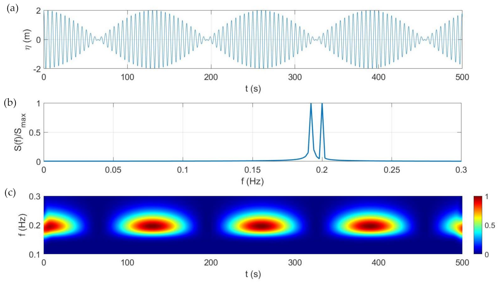
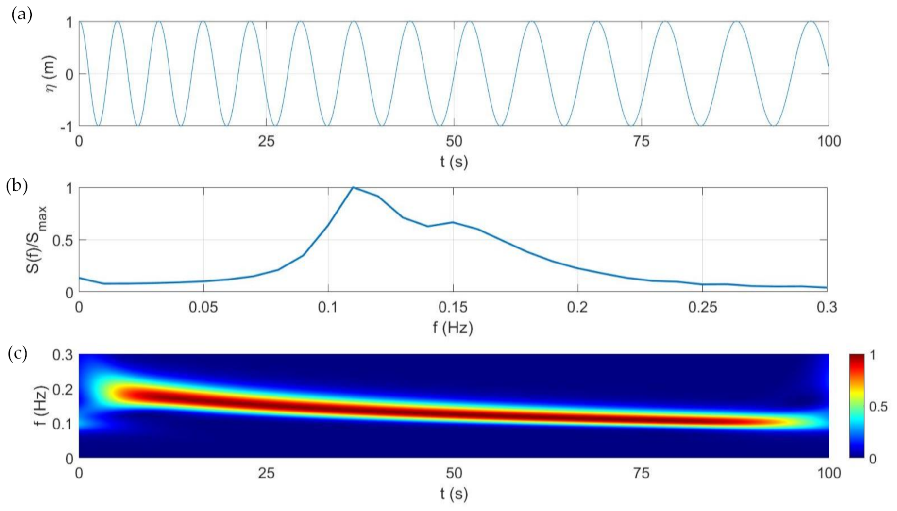
2.2. Wavelets vs. FFT
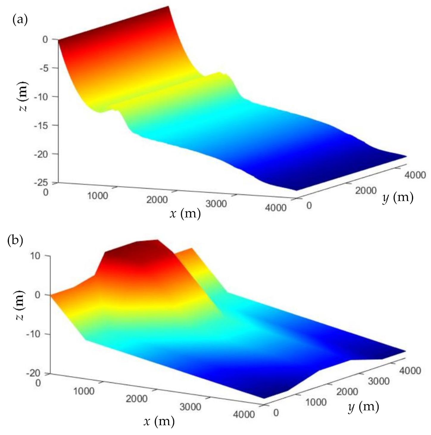
2.3. Sea Surface Synthetic Images
3. Results
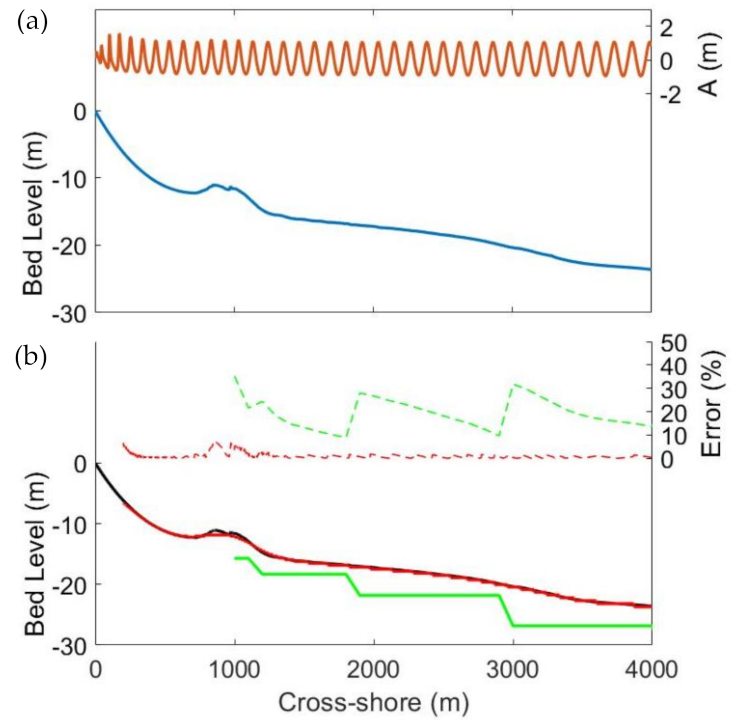
3.1. Regular Waves
3.2. Irregular Waves
4. Discussion
5. Conclusions
Author Contributions
Funding
Acknowledgments
Conflicts of Interest
References
- Jawak, S.D.; Vadlamani, S.S.; Luis, A.J. A Synoptic Review on Deriving Bathymetry Information Using Remote Sensing Technologies: Models, Methods and Comparisons. Adv. Remote Sens. 2015, 4, 147–162. [Google Scholar] [CrossRef] [Green Version]
- Bergsma, E.W.J.; Almar, R.; Maisongrande, P. Radon-Augmented Sentinel-2 Satellite Imagery to Derive Wave-Patterns and Regional Bathymetry. Remote Sens. 2019, 11, 1918. [Google Scholar] [CrossRef] [Green Version]
- Botha, E.; Brando, V.; Dekker, A.; Botha, E.J.; Brando, V.E.; Dekker, A.G. Effects of Per-Pixel Variability on Uncertainties in Bathymetric Retrievals from High-Resolution Satellite Images. Remote Sens. 2016, 8, 459. [Google Scholar] [CrossRef] [Green Version]
- Evagorou, E.G.; Mettas, C.; Agapiou, A.; Themistocleous, K.; Hadjimitsis, D.G. Bathymetric Maps from Multi-Temporal Analysis of Sentinel-2 Data: The Case Study of Limassol, Cyprus. Adv. Geosci. 2019, 45, 397–407. [Google Scholar] [CrossRef] [Green Version]
- Sagawa, T.; Yamashita, Y.; Okumura, T.; Yamanokuchi, T.; Sagawa, T.; Yamashita, Y.; Okumura, T.; Yamanokuchi, T. Satellite Derived Bathymetry Using Machine Learning and Multi-Temporal Satellite Images. Remote Sens. 2019, 11, 1155. [Google Scholar] [CrossRef] [Green Version]
- Almar, R.; Bergsma, E.W.J.; Maisongrande, P.; de Almeida, L.P.M. Wave-Derived Coastal Bathymetry from Satellite Video Imagery: A Showcase with Pleiades Persistent Mode. Remote Sens. Environ. 2019, 231, 111263. [Google Scholar] [CrossRef]
- Young, I.R. Wind Generated Ocean Waves, 1st ed.; Elsevier Ocean Engineering Book Series: Amsterdam, The Netherlands, 1999; Volume 2, pp. 1–288. [Google Scholar]
- Bergsma, E.W.J.; Almar, R. Video-based depth inversion techniques, a method comparison with synthetic cases. Coast. Eng. 2018, 138, 199–209. [Google Scholar] [CrossRef]
- Salameh, E.; Frappart, F.; Almar, R.; Baptista, P.; Heygster, G.; Lubac, B.; Raucoules, D.; Almeida, L.P.; Bergsma, E.W.J.; Capo, S.; et al. Monitoring Beach Topography and Nearshore Bathymetry Using Spaceborne Remote Sensing: A Review. Remote Sens. 2019, 11, 2212. [Google Scholar] [CrossRef] [Green Version]
- Brusch, S.; Held, P.; Lehner, S.; Rosenthal, W.; Pleskachevsky, A. Underwater bottom topography in coastal areas from Terra SAR-X data. Int. J. Remote Sens. 2011, 32, 4527–4543. [Google Scholar] [CrossRef]
- Mishra, M.K.; Ganguly, D.; Chauhan, P.; Ajai. Estimation of coastal bathymetry using RISAT 1 C-band microwave SAR data. IEEE Geosci. Remote Sens. Lett. 2014, 11, 671–675. [Google Scholar] [CrossRef]
- Pereira, P.; Baptista, P.; Cunha, T.; Silva, P.A.; Romão, S.; Lafon, V. Estimation of the Nearshore Bathymetry from High Temporal Resolution Sentinel-1A C-Band SAR Data—A Case Study. Remote Sens. Environ. 2019, 223, 166–178. [Google Scholar] [CrossRef]
- Tuteur, F.B. Wavelet Transformations in Signal Detection. IFAC Proc. 1988, 21, 1061–1065. [Google Scholar] [CrossRef]
- El-Diasty, M.; Al-Harbi, S. Development of wavelet network model for accurate water levels prediction with meteorological effects. Appl. Ocean Res. 2015, 53, 228–235. [Google Scholar] [CrossRef]
- El-Diasty, M. Satellite-Based Bathymetric Modeling Using a Wavelet Network Model. ISPRS Int. J. Geo. Inf. 2019, 8, 405. [Google Scholar] [CrossRef] [Green Version]
- Sancho, F.; Abreu, T.; D’Alessandro, F.; Tomasicchio, G.R.; Silva, P.A. Surf hydrodynamics in front of collapsing coastal dunes. J. Coast. Res. 2011, 1, 144–148. [Google Scholar]
- Abreu, T.; Silva, P.A.; Baptista, P.; Pais-Barbosa, J.; Fernández-Fernández, S.; Ferreira, C.; Matos, J. Analysis of Nonlinear Wave Parameters on Ofir Sandy Beach (NW Portugal). In Advances in Natural Hazards and Hydrological Risks: Meeting the Challenge; Fernandes, F., Malheiro, A., Chaminé, H., Eds.; Springer: Cham, Switzerland, 2020; pp. 147–151. [Google Scholar]
- Pacheco, A.; Horta, J.; Loureiro, C.; Ferreira, Ó. Retrieval of nearshore bathymetry from Landsat 8 images: A tool for coastal monitoring in shallow waters. Remote Sens. Environ. 2015, 159, 102–116. [Google Scholar] [CrossRef] [Green Version]
- Pushparaj, J.; Hegde, A.V. Estimation of bathymetry along the coast of Mangaluru using Landsat-8 imagery. Int. J. Ocean Clim. Syst. 2017, 8, 71–83. [Google Scholar] [CrossRef] [Green Version]
- Abreu, T.; Matos, J.; Pereira, P.; Cunha, T.R.; Baptista, P.; Silva, P.A. Acquisition of Bathymetric Data from Satellite Images. In Proceedings of the 8th SCACR—International Short Course/Conference on Applied Coastal Research, Santander, Spain, 3–6 October 2017. [Google Scholar]
- Pleskachevsky, A.; Lehner, S.; Heege, T.; Mott, C. Synergy and Fusion of Optical and Synthetic Aperture Radar Satellite Data for Underwater Topography Estimation in Coastal Areas. Ocean Dyn. 2011, 61, 2099–2120. [Google Scholar] [CrossRef] [Green Version]
- Lehner, S.; Pleskachevsky, A.; Bruck, M. High-resolution satellite measurements of coastal wind field and sea state. Int. J. Remote Sens. 2012, 33, 7337–7360. [Google Scholar] [CrossRef]
- Wiehle, S.; Pleskachevsky, A. Bathymetry Derived from Sentinel-1 Synthetic Aperture Radar Data. In Proceedings of the 12th European Conference on Synthetic Aperture Radar Electronic, Aachen, Germany, 4–7 July 2018. [Google Scholar]
- Zieliński, T. Wavelet transform applications in instrumentation and measurement: Tutorial and literature survey. Metrol. Meas. Syst. 2004, 11, 61–101. [Google Scholar]
- Shyu, H.; Sun, Y. Construction of a Morlet Wavelet Power Spectrum. Multidimens. Syst. Signal Process. 2002, 13, 101–111. [Google Scholar] [CrossRef]
- Kirby, J.T.; Wei, G.; Chen, Q.; Kennedy, A.B.; Dalrymple, R.A. FUNWAVE 1.0, Fully Nonlinear Boussinesq Wave Model, Documentation and User’s Manual, ReportCACR98-06; Center for Applied Coastal Research, Department of Civil and Environmental Engineering, University of Delaware: Newark, NJ, USA, September 1998. [Google Scholar]
- Shi, F.; Kirby, J.T.; Harris, J.C.; Geiman, J.D.; Grilli, S.T. A high-order adaptive time-stepping TVD solver for Boussinesq modeling of breaking waves and coastal inundation. Ocean Model. 2012, 43–44, 36–51. [Google Scholar] [CrossRef]
- Bertoluzza, S.; Naldi, G.; Ravel, J.C. Wavelet Methods for the Numerical Solution of Boundary Value Problems on the Interval. Wavelet Anal. Appl. 1994, 5, 425–448. [Google Scholar] [CrossRef]
- Ge, H.; Liu, H.; Zhang, L. Accurate Depth Inversion Method for Coastal Bathymetry: Introduction of Water Wave High-Order Dispersion Relation. J. Mar. Sci. Eng. 2020, 8, 153. [Google Scholar] [CrossRef] [Green Version]
- Flampouris, S.; Seeman, J.; Ziemer, F. Sharing our Experience Using Wave Theories Inversion for the Determination of the Local Depth. In Proceedings of the OCEANS 2009-EUROPE Conference, Bremen, Germany, 11–14 May 2009. [Google Scholar] [CrossRef]
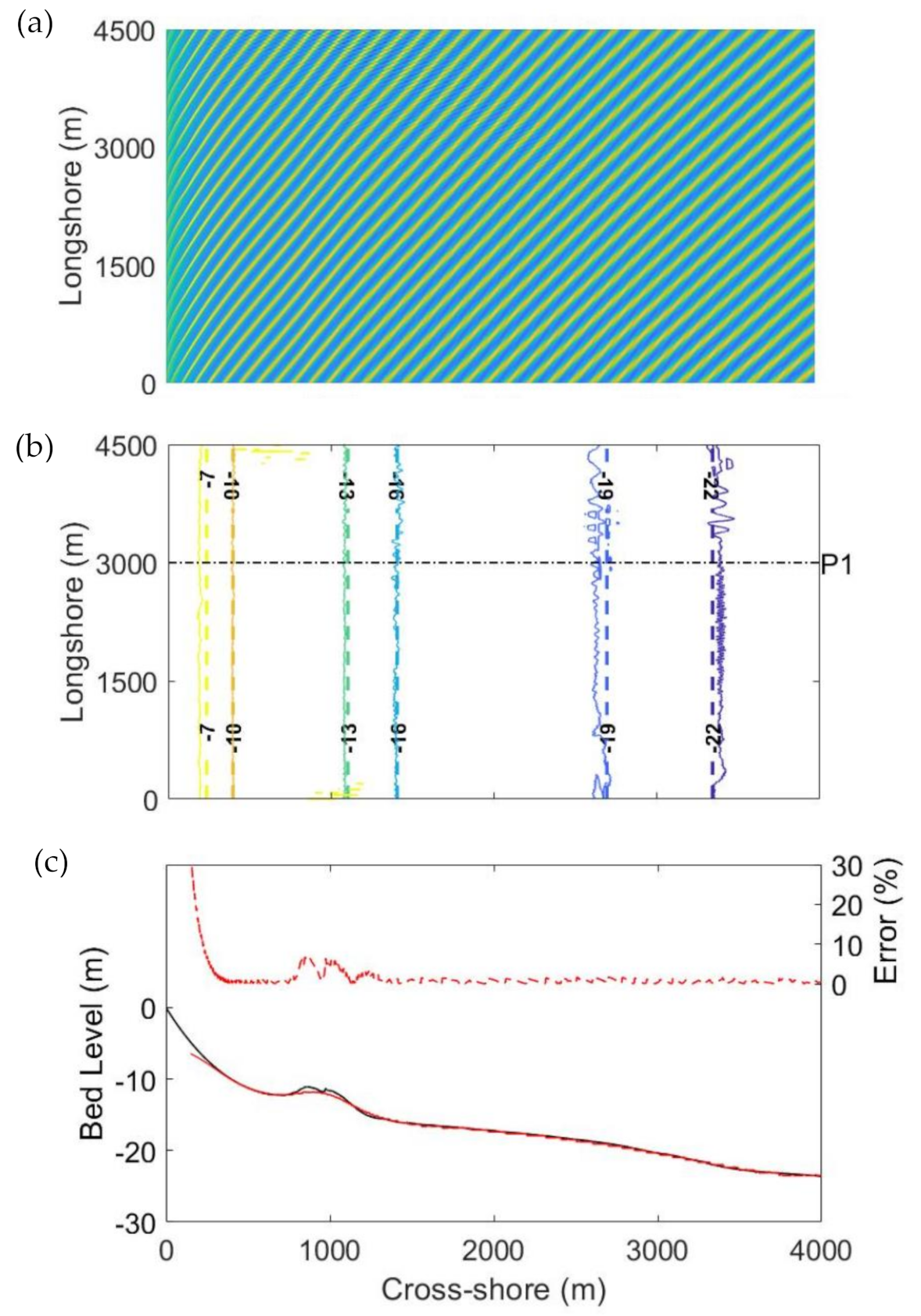

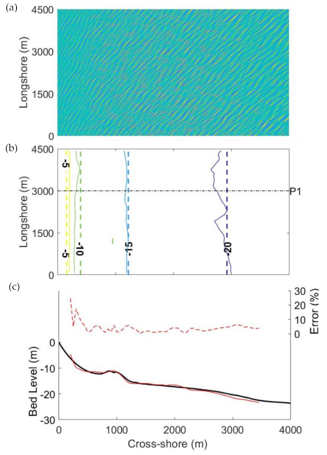
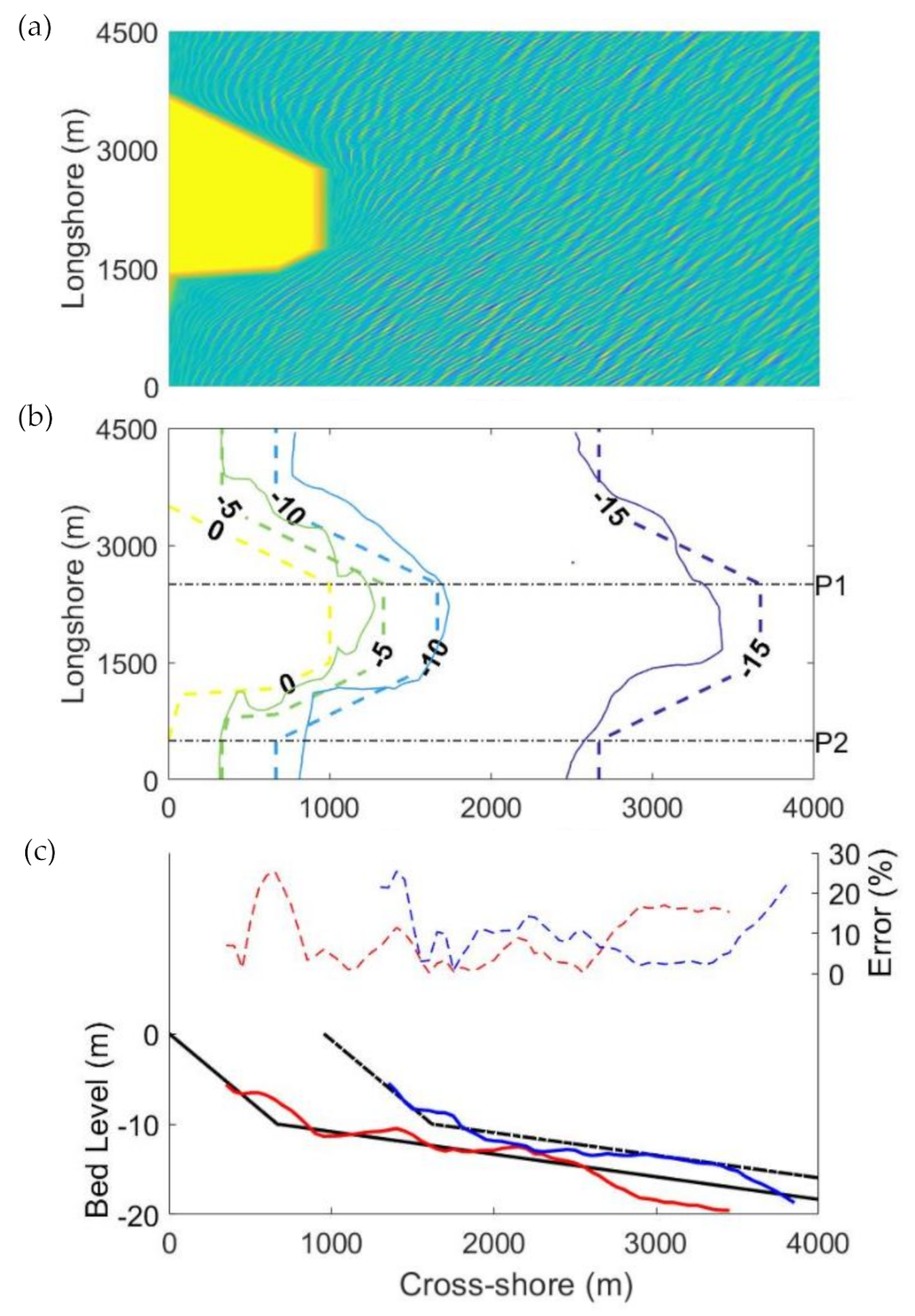
© 2020 by the authors. Licensee MDPI, Basel, Switzerland. This article is an open access article distributed under the terms and conditions of the Creative Commons Attribution (CC BY) license (http://creativecommons.org/licenses/by/4.0/).
Share and Cite
Santos, D.; Abreu, T.; Silva, P.A.; Baptista, P. Estimation of Coastal Bathymetry Using Wavelets. J. Mar. Sci. Eng. 2020, 8, 772. https://doi.org/10.3390/jmse8100772
Santos D, Abreu T, Silva PA, Baptista P. Estimation of Coastal Bathymetry Using Wavelets. Journal of Marine Science and Engineering. 2020; 8(10):772. https://doi.org/10.3390/jmse8100772
Chicago/Turabian StyleSantos, Diogo, Tiago Abreu, Paulo A. Silva, and Paulo Baptista. 2020. "Estimation of Coastal Bathymetry Using Wavelets" Journal of Marine Science and Engineering 8, no. 10: 772. https://doi.org/10.3390/jmse8100772
APA StyleSantos, D., Abreu, T., Silva, P. A., & Baptista, P. (2020). Estimation of Coastal Bathymetry Using Wavelets. Journal of Marine Science and Engineering, 8(10), 772. https://doi.org/10.3390/jmse8100772


