Beach Nourishment Alternatives for Mitigating Erosion of Ancient Coastal Sites on the Mediterranean Coast of Israel


Abstract
1. Introduction
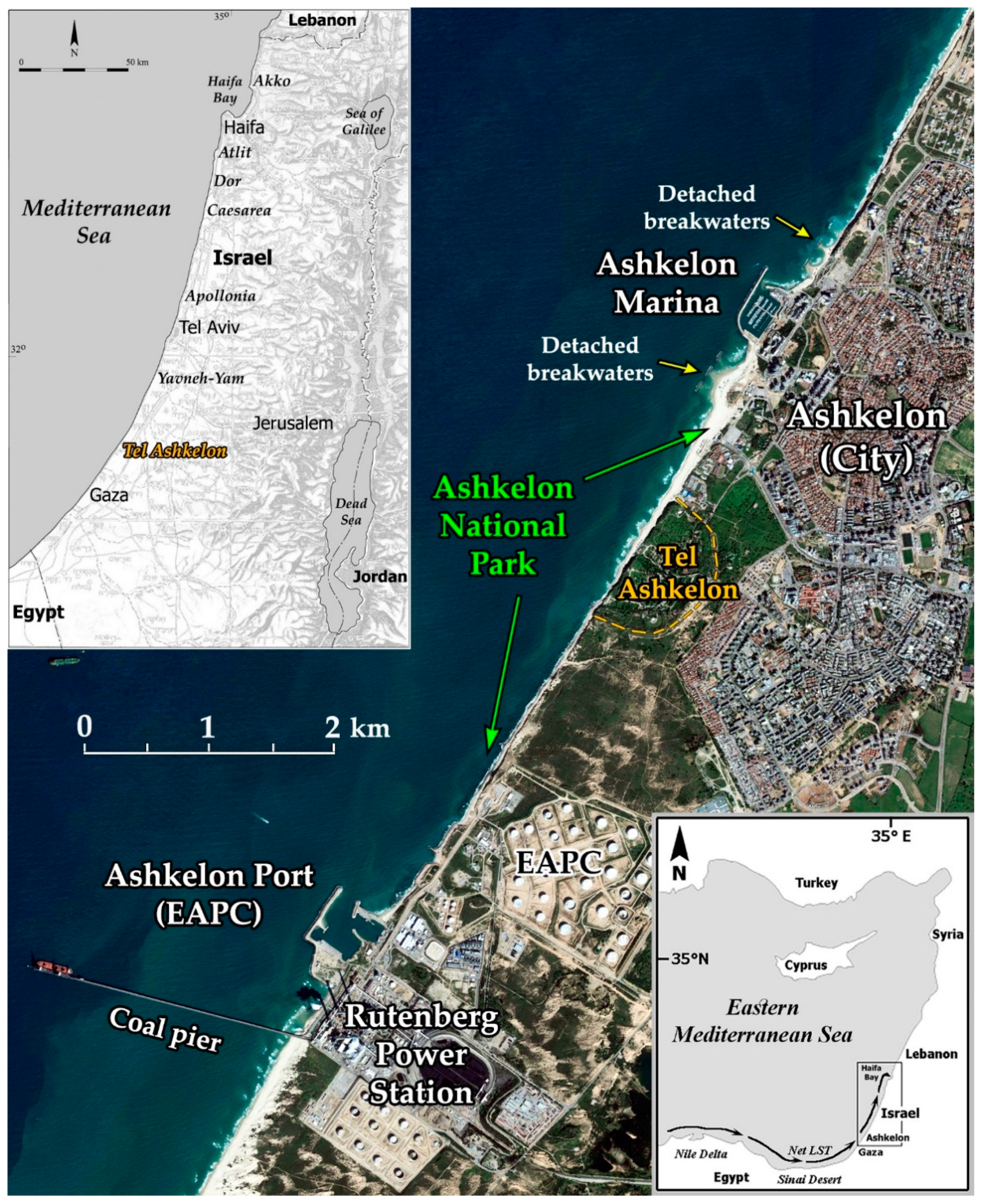
2. Study Area
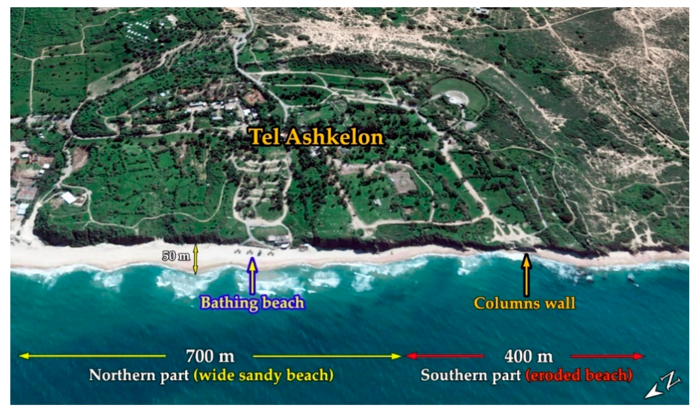
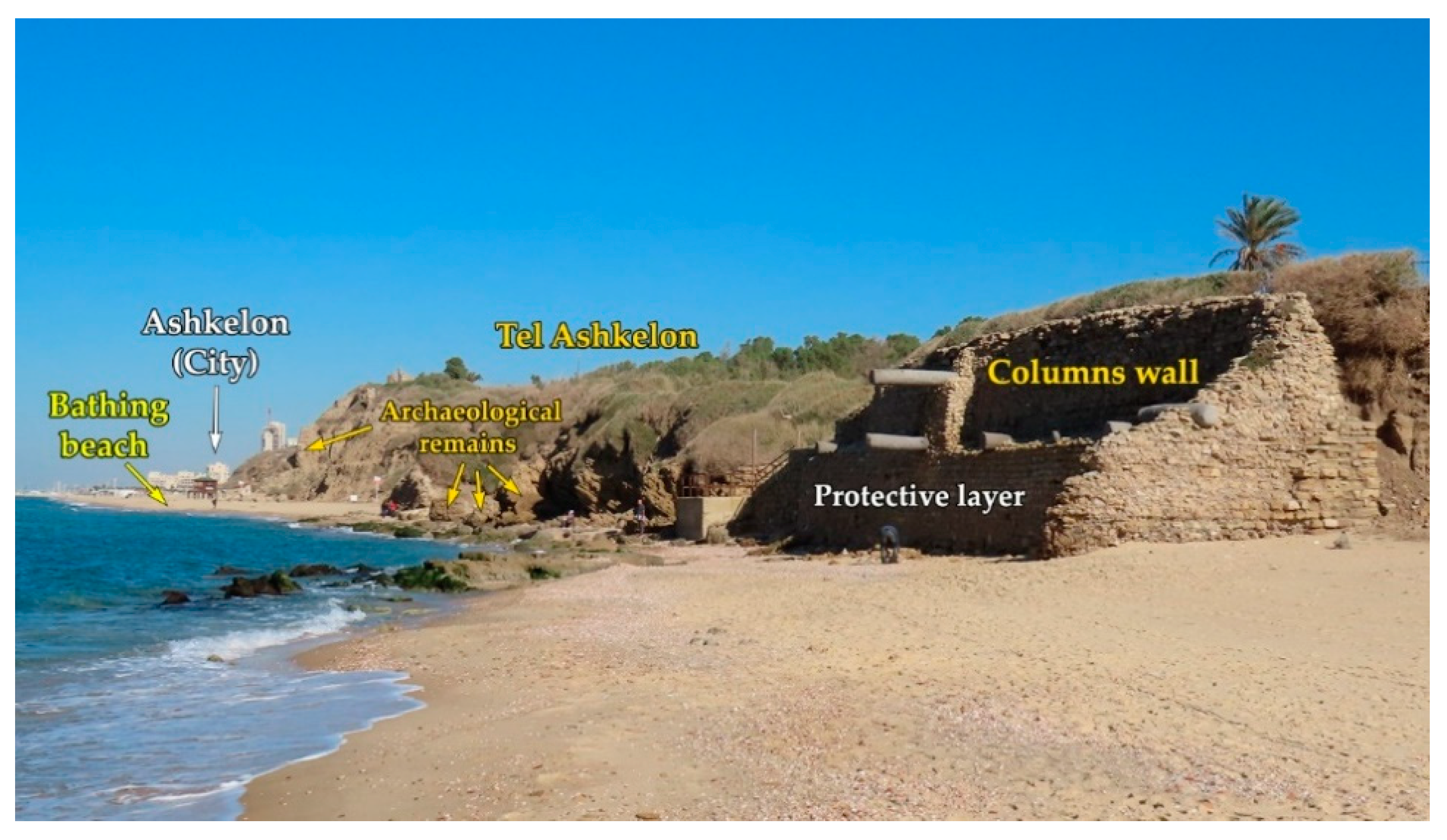
2.1. Tel Ashkelon: Historical and Archaeological Setting
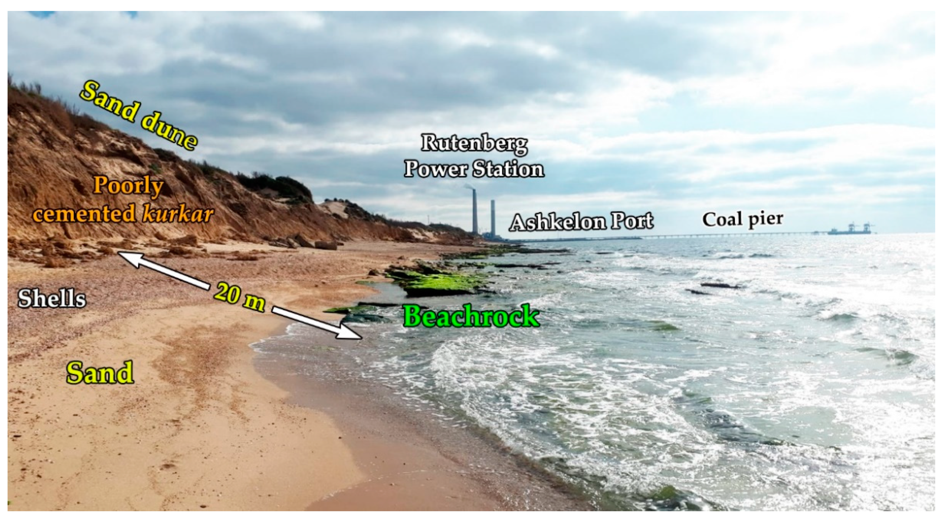
2.2. Ashkelon Coast: Physical Setting
2.3. Morphological Impact of Ashkelon Port
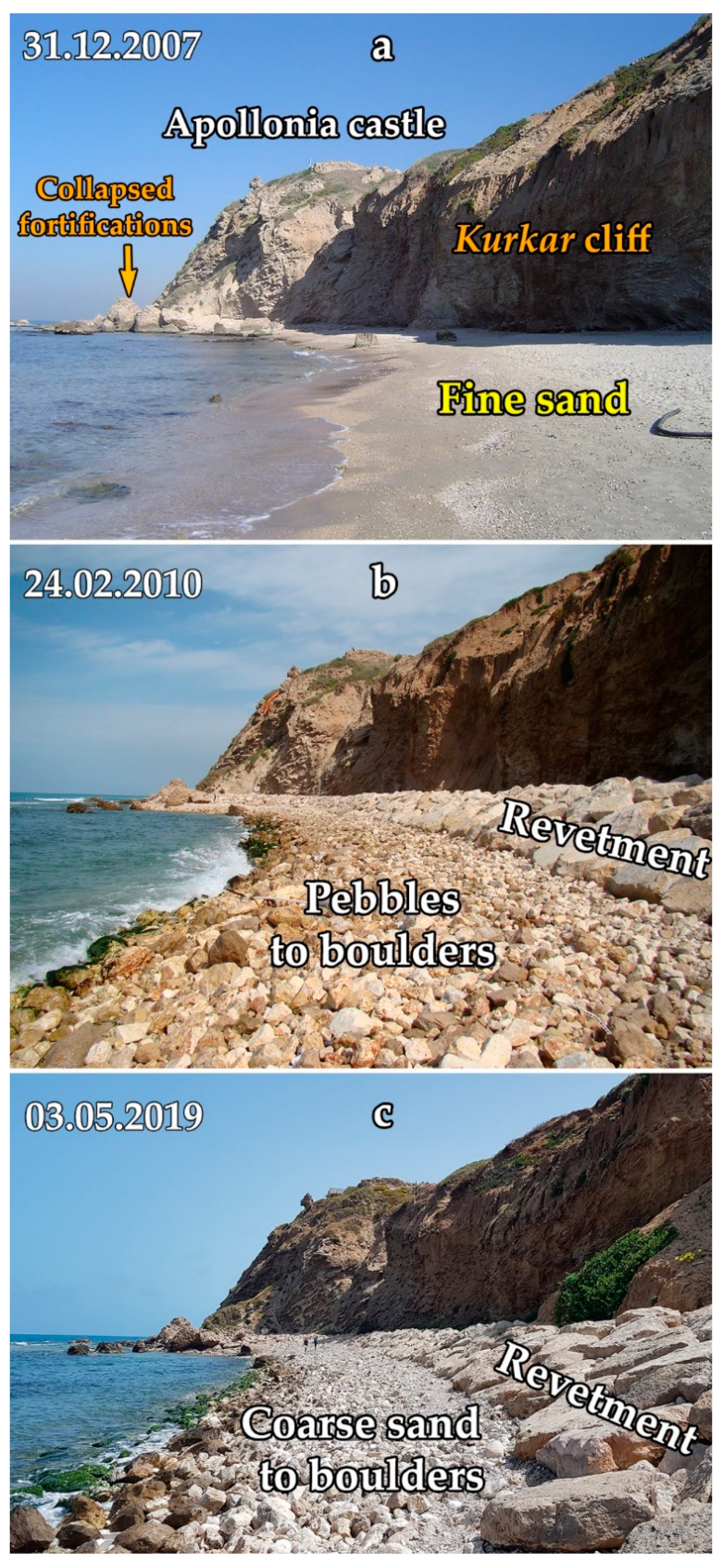
2.4. Tel Ashkelon Seafront: Previous Protection Planes and Nurishment Activities
2.5. Environmental Aspects
3. Methods
3.1. Grain Size Analysis
- Tel Ashkelon beach—Four samples (T1–T4) of the native sand were taken in December 2019 from the backshore near the Columns wall (Figure 5). The samples were dried at 50 °C for 48 h and then analyzed for grain size through American Standard Test Sieve Series (ASTM) sized from 63 to 2000 µm in the Sedimentology Laboratory of the University of Haifa.
- Rotem Plain sand quarry—Located in the Negev Desert, about 90 km southeast of Tel Ashkelon beach. Four samples were taken in August 2019 from the gathering area of the imported sand used for the north Ashkelon beach nourishment project [21]. The samples were analyzed using the above methodology.
- Ashkelon Port—Six samples were taken in July 2017 from the port’s navigation channel at water depth of 6–8 m (Figure 1). The samples were analyzed through a set of ASTM sieves sized from 63 to 2000 µm by KTE Co., Technologies & Enterprises representative of ALS Global Laboratory at Haifa.
- Offshore Ashkelon—A grab sample was taken at water depth of 20 m offshore Ashkelon, as a part of the Israeli sediment survey in August 2011. The samples were analyzed with a Malvern Mastersizer-2000 laser diffraction particle size analyzer in a range of 0–2000 µm in the Sedimentology Laboratory of the Geological Survey of Israel [48].
3.2. Stability Index
3.3. Pebble Alternative
3.4. Nourishment Unit Voulme and Cost Estimation
- Rotem Plain sand quarry—Royalties for quarry sand; loading sand on 20 m3 trucks; transportation cost from Rotem Plain to the gathering area near Tel Ashkelon beach; maintenance of the gathering site; construction of facilities for transporting the sand to the beach; bulldozing the sand on the beach. The total cost for these operations is about €52/m3 [47].
- Ashkelon Port—Rainbowing the sand via a discharge pipe at the bow of a dredging vessel (trailing suction hopper dredger), anchored at a water depth of 6 m. The dredging vessel conducts up to four cycles per day, about 800–1600 m3 of sand per load; bulldozing the sand onto the nourished site. The total cost is about €31/m3 (EDT Marine Construction pers. comm. 2020).
- Offshore Ashkelon—Operations and costs as for Ashkelon Port.
- Pebble alternative—Imported pebbles from Etziona quarry located about 52 km from nourishment site, including cost of pebbles, handling, transportation, and bulldozing on the site. The total cost is about €34/m3 (Etziona quarry CEO pers. comm. 2020).
4. Results and Discussion
4.1. Alternatives Evaluation
- Terrestrial sand quarried from Rotem Plain—The mean grain size is 384 µm, which is coarser than the native 290 µm by ratio of 1.34. The stability index of the sand is 0.57, which means that almost 60% of the imported grain size is coarser than all native sediment, and its durability cost score is 1.0. The volume of sand as assumed above is 200,000 m3 (500 m3/m length of beach). As the estimated cost for this sand nourishment is €52/m3, the expected total cost for this alternative is €10,400,000.
- Marine sand dredged from the Ashkelon Port area—The mean grain size, 282 µm, is a little finer than the native one, but the stability index of this sand is 0.27, which means that only small part of the material is compatible with the native one. The durability cost score is 2.1, which means that with regard to the terrestrial sand, this sand needs about twice the sand volume to obtain the results as the terrestrial sand. Although the direct cost of this sand per m3 is lower, it is uneconomic to use, as it needs a great quantity.
- Marine sand dredge offshore Ashkelon at a water depth of 20 m—This sand is completely incompatible with the native one; its stability index is very poor, and it should be rejected.
- Dolomite and limestone pebbles from Etziona quarry—Pebbles are much coarser than the native grain size, and this solution is economic. Its cost estimation is €34/m3 for the case study site and the expected total cost of this 36,000 m3 project is €1,224,000.
4.2. General Environment Consideration and Possible Negative Environmental Impacts
- The biota of sandy beaches may be affected, or even eliminated under the imported sediment [66].
- The use of heavy machinery to redistribute the sediment can limit the necessary movement of fauna along the beach [67].
- Physical changes along nourished beaches include formation of steep berms, or scarps, which can prevent turtles from reaching preferred nesting sites along the beach. As a result, eggs may be laid closer to the water, where they are more likely to be swept away by incoming tides and waves [71]. Nourished beaches are often harder (increased shear resistance) than the natural beaches, preventing attempts of nesting [71,72] and recover adequately within two to three years after project completion [71] and even up to seven years [73].
- Oil waste from substandard ship maintenance activities take in ports, may endanger all kinds of life forms on the beach [59].
5. Conclusions
- (1)
- Sediment used for a soft solution mitigation of beach erosion should be derived mainly from the nourishment aims, and the planned beach uses. Different sediment types (i.e., sand, gravel, pebbles) might be used for developing recreation beaches or protecting coastal infrastructures.
- (2)
- The stability index calculation grades sand alternatives for nourishment and durability.
- (3)
- Although the direct cost of marine sand for nourishment in the present case study is lower than that of terrestrial sand, its low stability makes its use inefficient and uneconomic in the long term. In the present study, we confirmed that the coarser the sand grain size is than the native one, the better is the stability of the nourished material.
- (4)
- The pebble solution is preferable for the specific purpose of protecting the southern part (400 m long) of Tel Ashkelon beach for the long run. It has the disadvantages of changing the biotic characteristics of the beach, and creating a new type of habitat. However, compared to the ever-changing beach in the eroded section, which is sometimes sandy and sometimes rocky, the pebble beach is a more stable habitat.
- (5)
- Terrestrial sand quarried from the Rotem Plain is incompatible with the native one (coarser and not from marine origin) and may result in a steeper and harder beach, which will disturb turtle nesting.
- (6)
- Marine sand dredged from Ashkelon Port area may include oil waste from ship maintenance activities in the harbor area.
- (7)
- Marine sand dredged offshore Ashkelon at a water depth of 20 m contains a high percentage of silt that may endanger the biota on the beach and the near shore.
- (8)
- Dolomite and limestone pebbles will prevent turtle nesting, and disturb bathing. Recovery of the beach for any present biota can hardly be expected. There is, nevertheless, the opportunity for the development of new and different types of biota that are adapted to the new gravel habitats.
- (9)
- Monitoring of the environmental impacts post-nourishment is crucial for further research and better practice.
Author Contributions
Funding
Acknowledgments
Conflicts of Interest
References
- Galili, E.; Rosen, B. Preserving the maritime cultural heritage of the Mediterranean, a cradle of cultures, religions and civilizations—The holy land perspective. J. Coast. Conserv. 2010, 14, 303–315. [Google Scholar] [CrossRef]
- Anthony, E.J.; Marriner, N.; Morhange, C. Human influence and the changing geomorphology of Mediterranean deltas and coasts over the last 6000 years: From progradation to destruction phase? Earth-Sci. Rev. 2014, 139, 336–361. [Google Scholar] [CrossRef]
- Raban, A.; Galili, E. Recent maritime archaeological research in Israel—A preliminary report. Int. J. Naut. Archaeol. 1985, 14, 321–356. [Google Scholar] [CrossRef]
- Galili, E.; Zviely, D.; Bresler, G.; Valeria, B.; Rosen, B. Ancient coastal settlements of Israel: Endangered cultural resource. In Proceedings of the Second International Conference/Workshop on the State-of-the-Art of ICM in the Mediterranean & the Black Sea: Immediate Needs for Research, Education/Training & Implementation, MED & BLACK SEA ICM 08; Özhan, E., Ed.; Mediterranean Coastal Foundation: Akyaka, Muğla, Turkey, 2008; pp. 147–158. [Google Scholar]
- Galili, E.; Oron, A.; Cvikel, D. Five decades of marine archaeology in Israel. J. East. Mediter. Archaeol. Herit. Stud. 2018, 6, 9–51. [Google Scholar] [CrossRef]
- Galili, E.; Arenson, S. Ancient coastal and underwater sites on the Mediterranean coast of Israel: Risk assessment, protection, salvage excavations and conservation of endangered maritime cultural resources part II. Riparia 2015, 1, 55–96. [Google Scholar] [CrossRef]
- Galili, E.; Arenson, S. Israel’s marine treasures–endangered cultural resource. The ancient Near East today. ASOR Blog 2016, 4, 1. [Google Scholar]
- Sarà, G.; Milanese, M.; Prusina, I.; Sarà, A.; Angel, D.L.; Glamuzina, B.; Nitzan, T.; Freeman, S.; Rinaldi, A.; Palmeri, V.; et al. The impact of climate change on Mediterranean intertidal communities: Losses in coastal ecosystem integrity and services. Reg. Environ. Chang. 2014, 14, 5–17. [Google Scholar] [CrossRef]
- Avi-Yonah, M.; Eph’al, Y. Ashqelon. In Encyclopedia of Archaeological Excavations in the Holy Land; Avi-Yonah, M., Stern, E., Eds.; Prentice-Hall Inc.: Upper Saddle River, NJ, USA, 1975; Volume 1, pp. 121–130. [Google Scholar]
- Stager, L. Ashqelon. In The New Encyclopedia for Archaeological Excavations in Israel; Stern, E., Levinzon-Gilboa, A., Aviram, J., Eds.; Israel Exploration Society and Carta: Jerusalem, Israel, 1992; Volume 1, p. 98. (In Hebrew) [Google Scholar]
- Stager, L.E.; Schloen, J.D. Introduction: Ashkelon and its inhabitants. In Ashkelon 1: Introduction and Overview (1985–2006); Stager, L.E., Schloen, J.D., Master, D.M., Eds.; Final Repots of the Leon Levy Expedition to Ashkelon 1; Eisenbrauns: Winona Lake, IN, USA, 2008; pp. 3–15. [Google Scholar]
- Prawer, J. The City and Duchy of Ascalon in the Crusader Period. Eretz-Israel Archaeol. Hist. Geogr. Stud. 1958, 5, 224–237. (In Hebrew) [Google Scholar]
- Benvenisti, M. The Crusaders in the Holy Land; Israel Universities Press: Jerusalem, Israel, 1970. [Google Scholar]
- Kedar, B.Z.; Mook, W.G. Radiocarbon dating of mortar from the city-wall of Ascalon. Israel Explor. J. 1978, 173–176. [Google Scholar] [CrossRef]
- Galili, E.; Sharvit, J.; Dahari, U. Ashkelon and the sea in light of the marine and coastal archaeological finds. In Ashkelon—A Coastal City; Sasson, A., Safrai, Z., Sagiv, N., Eds.; Tel Aviv University Press: Tel Aviv, Israel, 2001; pp. 11–38, (In Hebrew, English abstract). [Google Scholar]
- Hanson, H.; Brampton, A.; Capobianco, M.; Dette, H.H.; Hamm, L.; Laustrup, C.; Lechuga, A.; Spanhoff, R. Beach nourishment projects, practices, and objectives—A European overview. Coast. Eng. 2002, 47, 81–111. [Google Scholar] [CrossRef]
- Özhan, E. Coastal Erosion Management in the Mediterranean; UNEP; MAP; Priority Actions Programme; Regional Activity Centre; Ankara/Split: Ankara, Turkey, 2002. [Google Scholar]
- Cooney, B.C.; Forrest, K.D.; Miller, J.R.; Moeller, F.U.; Parker, J.K. Beach Nourishment: Global Perspectives and Local Applications to the North Carolina Coastline; Carolina Environmental Program: Capstone Experience Conducted at the UNC Chapel Hill Institute of Marine Sciences: Morehead City, NC, USA, 2003. [Google Scholar]
- Dean, R.G. Beach Nourishment: Theory and Practice; World Scientific Publishing Company: Singapore, 2003; Volume 18. [Google Scholar]
- Waterman, R.E. Integrated Coastal Policy via Building with Nature; Opmeer BV: The Hague, The Netherlands, 2008. [Google Scholar]
- Bitan, M.; Zviely, D. Sand beach nourishment: Experience from the Mediterranean coast of Israel. J. Mar. Sci. Eng. 2020, 8, 273. [Google Scholar] [CrossRef]
- Semeoshenkova, V.; Newton, A. Overview of erosion and beach quality issues in three southern European countries: Portugal, Spain and Italy. Ocean Coast. Manag. 2015, 118, 12–121. [Google Scholar] [CrossRef]
- Cohen, O.; Anthony, J.E. Gravel beach erosion and nourishment in Nice, French Riviera. J. Mediter. Geogr. 2007, 108, 99–103. [Google Scholar] [CrossRef]
- Haney, R.; Kouloheras, L.; Malkoski, V.; Mahala, J.; Unger, Y. Beach Nourishment; MassDEP’s Guide to Best Management Practices for Projects in Massachusetts; Massachusetts Department of Environmental Protection and Massachusetts Office of Coastal Zone Management: Boston, MA, USA, 2007.
- Galili, E.; Rosen, B.; Finkielsztejn, G. Stone anchors bearing inscriptions from Ashkelon. Atiqot 2012, 71, 113–127, 121–122. [Google Scholar]
- Galili, E.; Rosen, B. Lead cooking braziers from a shipwreck off the Ashkelon coast, Israel. In Shipwrecks around the World: Revelations of the Past; Tripati, S., Ed.; Delta/Kaveri Book Service: New Delhi, India, 2015; Chapter 15; pp. 335–346. [Google Scholar]
- Galili, E.; Rosen, B.; Arenson, S.; Nir-El, Y.; Jacoby, D. Cargo of lead ingots from a shipwreck off Ashkelon, Israel 11th–13th centuries CE. Int. J. Naut. Archaeol. 2019, 48, 453–465. [Google Scholar] [CrossRef]
- Guérin, V. Description Géographique Historique et Archéologique de la Palestine. 1: Judee, pt. 2; L’Imprimerie Nationale: Paris, French, 1869. (In French) [Google Scholar]
- Galili, E.; Rosen, B.; Oron, A. Marine wooden structures from Roman/Byzantine Ashkelon, Israel. In Honor Frost Foundation, ‘Under the Mediterranean’ Conference; Blew, L., Ed.; Nicosia, Cyprus, 2017. (In press)
- Almagor, G.; Perath, I. The Mediterranean Coast of Israel; Report GSI/28/2016; Geological Survey of Israel (GSI): Jerusalem, Israel, 2016. (In Hebrew)
- Inman, D.L.; Jenkins, S.A. The Nile littoral cell and man’s impact on the coastal zone of the southeastern Mediterranean. In Proceedings of the 19th International Conference on Coastal Engineering, Houston, TX, USA, 3–7 September 1984; ASCE: Houston, TX, USA, 1984; pp. 1600–1617. [Google Scholar]
- Stanley, D.J. Sediments transport on the coast and shelf between the Nile Delta and Israeli margin as determined by heavy minerals. J. Coast. Res. 1989, 5, 813–828. [Google Scholar]
- Sharaf El Din, S.H.; Mahar, A.M. Evaluation of sediment transport along the Nile Delta coast, Egypt. J. Coast. Res. 1997, 13, 23–26. [Google Scholar]
- Frihy, O.E.; Badr, A.A.; Selim, M.A.; El Sayed, W.R. Environmental impacts of El Arish power plant on the Mediterranean coast of Sinai. Egypt. Environ. Geol. 2002, 42, 604–611. [Google Scholar]
- Khalifa, M.A.; El Ganainy, M.A.; Nasr, R.I. Wave transformation and longshore sediment transport evaluation for the Egyptian northern coast, via extending modern formulae. J. Coast. Res. 2009, 25, 755–767. [Google Scholar] [CrossRef]
- Emery, K.O.; Neev, D. Mediterranean beaches of Israel. Israel Geol. Surv. Bull. 1960, 26, 1–24. [Google Scholar]
- Goldsmith, V.; Golik, A. Sediment transport model of the southeastern Mediterranean coast. Mar. Geol. 1980, 37, 135–147. [Google Scholar] [CrossRef]
- Carmel, Z.; Inman, D.; Golik, A. Directional wave measurements at Haifa, Israel, and sediment transport along the Nile littoral cell. Coast. Eng. 1985, 9, 21–36. [Google Scholar] [CrossRef]
- Perlin, A.; Kit, E. Longshore sediment transport on the Mediterranean coast of Israel. J. Waterway Port Coast. Ocean Eng. 1999, 125, 80–87. [Google Scholar] [CrossRef]
- Zviely, D.; Kit, E.; Klein, M. Longshore sand transport estimates along the Mediterranean coast of Israel in the Holocene. Mar. Geol. 2007, 237, 61–73. [Google Scholar] [CrossRef]
- Zviely, D. The Gift of the Nile—Israel’s marine sand resource: Sources, uses and quantities. In The Maritime Strategic Evaluation for Israel 2018/19; Chorev, S., Gonen, E., Eds.; Maritime Policy & Strategy Research Center: University of Haifa: Haifa, Israel, 2019; pp. 285–301. (In Hebrew) [Google Scholar]
- Golik, A.; Goldsmith, V. Coastal changes in the Katif, Gaza and Ashqelon Areas; Report H-4/85, Submitted to the Mediterranean-Dead Sea Canal Company; Israel Oceanographic and Limnological Research: Haifa, Israel, 1985. [Google Scholar]
- Vidja, M.; Rosen, D. Ashkelon Harbor—Opinion on Sedimentological Impacts; Report P.N.191/87; CAMERI-Coastal and Marine Engineering Research Institute, Technion: Haifa, Israel, 1987. (In Hebrew) [Google Scholar]
- Shoshany, M. Shoreline Mapping in the Area of Rutenberg—Katza (Eilat-Ashkelon Pipeline Company) for the Years of 1956–1989; Submitted to the Israel Electric Corporation, Environment Department; Department of Geography, Bar-Ilan University: Ramat Gan, Israel, 1991. (In Hebrew) [Google Scholar]
- Kit, E.; Sladkevich, M. Analysis of Sediment Transport Effects on Marine Structures and on the Morphological Changes in the Vicinity of the Rutenberg Power Station; Report P.N. 447/96; CAMERI—Coastal and Marine Engineering Research Institute, Technion City: Haifa, Israel, 1996. [Google Scholar]
- CORINTE ENGINNERING. Geotextile Structures for Beach Protection—Ashkelon, Israel. Design of the Marine Works: Area 39; Design Report Area 39 Progress Report; Prepared for The Mediterranean Coastal Cliffs Preservation Government Company Ltd.: Netanya, Israel, 2017.
- AVIV AMCG. Cell 39 Analysis—Ashkelon National Park; The Mediterranean Coastal Cliffs Preservation Government Company Ltd.: Netanya, Israel, 2016. (In Hebrew)
- Almogi-Labin, A.; Calvo, R.; Elyashiv, H.; Amit, R.; Harlavan, Y.; Herut, B. Sediment Characterization of the Israeli Mediterranean Shelf (10–100 m); Report GSI/27/2012; Geological Survey of Israel (GSI) and Israel Oceanographic and Limnological Research (IOLR): Jerusalem, Israel, 2012.
- Cammelli, C.; Jackson, N.L.; Nordstrom, K.F.; Pranzini, E. Assessment of gravel nourishment project fronting a seawall at Marina Di Pisa, Italy. J. Coast. Res. 2006, SI 39, 770–775. [Google Scholar]
- Pranzini, E.; Anfuso, G.; Muñoz-Perez, J.J. A probabilistic approach to borrow sediment selection in beach nourishment projects. Coast. Eng. 2018, 139, 32–35. [Google Scholar] [CrossRef]
- Pranzini, E.; Cinelli, I.; Cipriani, L.E.; Anfuso, G. An integrated coastal sediment management plan: The example of the Tuscany region (Italy). J. Mar. Sci. Eng. 2020, 8, 33. [Google Scholar] [CrossRef]
- Anthony, E.J.; Olivier Cohen, O.; Sabatier, F. Chronic offshore loss of nourishment on Nice beach, French Riviera: A case of over-nourishment of a steep beach? Coast. Eng. 2011, 58, 374–383. [Google Scholar] [CrossRef]
- Pranzini, E. Italy. In Coastal Erosion and Protection in Europe; Pranzini, E., Williams, A.T., Eds.; Routledge: London, UK, 2013; Chapter 15; pp. 294–324. [Google Scholar]
- Finkl, C.W.; Walker, H.J. Beach Nourishment. In Encyclopedia of Coastal Science, 2rd ed.; Finkl, C.W., Makowski, C., Eds.; Springer Nature: Basel, Switzerland, 2019; pp. 259–275. [Google Scholar]
- Leonard, L.; Clayton, T.; Pilkey, O. An analysis of replenished beach design parameters on U.S. East Coast barrier islands. J. Coast Res. 1990, 6, 15–36. [Google Scholar]
- Pilkey, O.H. A time to look back at beach renourishment. J. Coast Res. 1990, 6, iii–vii. [Google Scholar]
- Dean, R.G. Equilibrium beach profiles: Characteristics and applications. J. Coast Res. 1991, 7, 53–84. [Google Scholar]
- Pranzini, E. Beach erosion and protection in Tuscany. In Monitoring Results: A Capitalization Tool from COASTGAP Project; Cipriani, L.E., Pranzini, E., Eds.; Nuova Grafica Fiorentina: Firenze, Italy, 2014; p. 138. [Google Scholar]
- Foteinis, S.; Kallithrakas-Kontos, N.G.; Synolakis, C. Heavy metal distribution in opportunistic beach nourishment: A case study in Greece. Sci. World J. 2013. [Google Scholar] [CrossRef] [PubMed]
- Dean, R.G. Compatibility of borrow material for beach fills. In Proceedings of the 14th International Conference on Coastal Engineering, Copenhagen, Denmark, 24–28 June 1974; ASCE: Copenhagen, Denmark, 1974; pp. 1319–1333. [Google Scholar]
- Garland, G.G. Sand mass density and borrow material compatibility for beach nourishment. Ocean Shorel. Manag. 1990, 13, 89–98. [Google Scholar] [CrossRef]
- Swart, D.H. Beach nourishment and particle size effects. Coast. Eng. 1991, 16, 61–81. [Google Scholar] [CrossRef]
- Charles, H.; Bishop, M. Assessing the environmental impacts of beach nourishment. BioScience 2005, 55, 887–896. [Google Scholar]
- Dean, R.G. Principles of beach nourishment. In Handbook of Coastal Processes and Erosion; Komar, P.D., Ed.; CRC Press: Boca Raton, FL, USA, 1983; Chapter 11; pp. 217–232. [Google Scholar]
- Peterson, C.H.; Laney, T.R.W. Biological impacts of beach nourishment. In Workshop on the Science of Beach re Nourishment; Pine Knoll Shores: Carteret County, NC, USA, 2001. [Google Scholar]
- Naqvi, S.; Pullen, E. Effects of Beach Nourishment and Borrowing on Marine Organisms; Miscellaneous Report No. 82-14; U.S. Army Corps of Engineers, Coastal Engineering Research Center: Fort Belvoir, VA, USA, 1982.
- Rice, T. The big picture: An overview of coastal resources and federal projects. In Proceedings of the Coastal Ecosystems & Federal Activities Technical Training Symposium, Gulf Shores, AL, USA, 20–22 August 2001. [Google Scholar]
- Van Dolah, R.F.; Wendt, P.H.; Martore, R.M.; Levisen, M.V.; Roumillat, W.A. A Physical and Biological Monitoring Study of the Hilton Head Beach Nourishment Project; Unpublished; South Carolina Wildlife and Marine Resources Department for Town of Hilton Head Island: Hilton Head Island, SC, USA, 1992.
- Parkinson, R.W.; Venanzi, P.F.; Fizpatrick, K. Preliminary observations of a long term turbidity study, Sebastian Inlet, Florida. Preserving and Enhancing our Beach Environment. In Proceedings of the 4th Annual National Beach Preservation Association, Cleveland, OH, USA, 22–23 May 1991; pp. 295–310. [Google Scholar]
- Van Dolah, R.F.; Martore, R.M.; Lynch, A.E.; Levisen, M.V.; Wendt, P.H.; Whitaker, D.J.; Anderson, W.D. Final Report: Environmental Evaluation of the Folly Beach Nourishment Project; U.S. Army Corps of Engineers, Charleston District: Charleston, SC, USA, 1994.
- Steinitz, M.J.; Salmon, M.; Wyneken, J. Beach re nourishment and loggerhead turtle reproduction: A seven year study at Jupiter Island, Florida. J. Coast Res. 1998, 14, 1000–1013. [Google Scholar]
- Nelson, D.A.; Dickerson, D.D. Effects of beach re nourishment on sea turtles. In Proceedings of the Ninth Annual Workshop on Sea Turtle Conservation and Biology, Jekyll Island, GA, USA, 7–11 February 1989; Eckert, S.A., Eckert, K.L., Richardson, T.H., Eds.; NOAA Technical Memorandum NMFS-SEFSC-232: Jekyll Island, GA, USA, 1989; pp. 125–127. [Google Scholar]
- Moulding, J.; Nelson, D. Beach nourishment issues related to sea turtle nesting. In Proceedings of the Symposium of Coastal Water Resources, Wilmington, NC, USA, 22–25 May 1988; Lyke, W., Hoban, T., Eds.; Technical Publication Series TPS-88-1. American Water Resources: Bethesda, MD, USA, 1988; pp. 87–93. [Google Scholar]


| Sieve Size | Tel Ashkelon Weight | Cumulative Weight Cni | Sfi | Rotem Quarry | Rotem Quarry | Ashkelon Port | Ashkelon Port | Offshore Ashkelon | Offshore Ashkelon |
|---|---|---|---|---|---|---|---|---|---|
| µm | % | % | Fbi % | FbixSfi | Fbi % | FbixSfi | Fbi % | FbixSfi | |
| 2000 | 0.59 | 0.59 | 0.59 | 2.32 | 1.37 | 3.94 | 2.32 | 0.00 | 0.00 |
| 1000 | 0.41 | 1.00 | 0.99 | 4.05 | 4.02 | 2.41 | 2.39 | 0.00 | 0.00 |
| 500 | 14.63 | 15.63 | 0.92 | 31.54 | 28.92 | 7.60 | 6.97 | 0.00 | 0.00 |
| 250 | 77.36 | 92.99 | 0.46 | 49.56 | 22.64 | 29.70 | 13.57 | 14.15 | 6.47 |
| 125 | 6.01 | 99.00 | 0.04 | 11.14 | 0.45 | 42.30 | 1.69 | 79.55 | 3.19 |
| 90 | 0.06 | 99.06 | 0.01 | 0.81 | 0.01 | 10.30 | 0.10 | 0.91 | 0.01 |
| 63 | 0.00 | 99.06 | 0.01 | 0.50 | 0.00 | 8.60 | 0.08 | 5.37 | 0.05 |
| Si | - | - | - | - | 0.57 | - | 0.27 | - | 0.10 |
| d50 (µm) | 290 | - | - | 384 | - | 282 | - | 138 | - |
| Durability Cost Score | - | - | - | - | 1.0 | - | 2.1 | - | 5.7 |
| Alternative | m3/m Length of Beach | Total Nourished Volume (m3) | Stability Index | Coefficient of Durability Cost | Cost for 1 m3 of Sediment (€) | Total Cost −1000€ |
|---|---|---|---|---|---|---|
| Terrestrial Sand from Rotem Plain Quarry | 500 | 200,000 * | 0.57 | 1 | 52 | 10,400 |
| Marine Sand Dredged in Ashkelon Port | 1050 | 420,000 ** | 0.27 | 2.1 | 31 | 13,020 |
| Marine Sand Dredged Offshore Ashkelon | Not Relevant | Not Relevant | 0.1 | 5.7 | 31 | Not Relevant |
| Pebble | 90 | 36,000 | 1 *** | <1.0 | 34 | 1224 |
© 2020 by the authors. Licensee MDPI, Basel, Switzerland. This article is an open access article distributed under the terms and conditions of the Creative Commons Attribution (CC BY) license (http://creativecommons.org/licenses/by/4.0/).
Share and Cite
Bitan, M.; Galili, E.; Spanier, E.; Zviely, D. Beach Nourishment Alternatives for Mitigating Erosion of Ancient Coastal Sites on the Mediterranean Coast of Israel. J. Mar. Sci. Eng. 2020, 8, 509. https://doi.org/10.3390/jmse8070509
Bitan M, Galili E, Spanier E, Zviely D. Beach Nourishment Alternatives for Mitigating Erosion of Ancient Coastal Sites on the Mediterranean Coast of Israel. Journal of Marine Science and Engineering. 2020; 8(7):509. https://doi.org/10.3390/jmse8070509
Chicago/Turabian StyleBitan, Menashe, Ehud Galili, Ehud Spanier, and Dov Zviely. 2020. "Beach Nourishment Alternatives for Mitigating Erosion of Ancient Coastal Sites on the Mediterranean Coast of Israel" Journal of Marine Science and Engineering 8, no. 7: 509. https://doi.org/10.3390/jmse8070509
APA StyleBitan, M., Galili, E., Spanier, E., & Zviely, D. (2020). Beach Nourishment Alternatives for Mitigating Erosion of Ancient Coastal Sites on the Mediterranean Coast of Israel. Journal of Marine Science and Engineering, 8(7), 509. https://doi.org/10.3390/jmse8070509