Article

The Joint Phantom Track Deception and TDOA/FDOA Localization Using UAV Swarm without Prior Knowledge of Radars’ Precise Locations

1
Beijing Blue Sky Innovation Center for Frontier Science, Beijing 100085, China
2
Institute of Systems Engineering, Military Academy of Sciences, Beijing 100085, China
*
Authors to whom correspondence should be addressed.
Electronics 2022, 11(10), 1577; https://doi.org/10.3390/electronics11101577
Submission received: 25 March 2022 / Revised: 4 May 2022 / Accepted: 7 May 2022 / Published: 14 May 2022

Abstract

:
This paper develops the model of the joint phantom track deception and the joint techniques of time-difference of arrival (TDOA) and frequency-difference of arrival (FDOA) localization to deceive air defense radar networks under the condition that an unmanned aerial vehicle (UAV) swarm has no prior knowledge of the radars’ precise locations, and related performance experiment and analysis are presented to demonstrate the effectiveness of the proposed method and to clarify the influence factors of phantom track deception. The main contributions of this paper are as follows. Firstly, the model of phantom track deception against a radar network by UAV swarm without prior knowledge of the radars’ positions are established. Secondly, TDOA/FDOA are adapted to locate networked enemy radars using UAV swarm, where the Fisher information matrix (FIM) is derived to evaluate the estimation accuracy. Thirdly, the uncertainty analysis consisting of radar location error and UAV position error is deduced. With these efforts, the integrated capability of sensing and jamming is realized. Moreover, the same source testing using space resolution cell (SRC) from the perspective of a radar network is executed to provide guidance for phantom track design. Finally, performance experiment and analysis are given to verify the theoretical analysis with simulation results.

1. Introduction

It is an active area of research that uses cooperative UAVs to generate a phantom track and deceive the enemy radar network, causing the network to track the motion of a phantom or nonexistent air vehicle [1,2,3]. The UAVs are assumed to be stealthy and are capable of intercepting radar signals and retransmitting them with a delay time, resulting in the radar perceiving a phantom track beyond the real UAVs, and misleading the radar network to track the phantom target.
In this research area, some teams have made great contributions. Pachter, Purvis et.al came up with the concept of phantom track deception and analyzed the relevant problem in the 2D scenario [4,5,6,7,8]. Also for 2-D scenarios, Maithripala and Dhananjay studied the phantom track generation using the line-of-sight (LOS) guidance law [9,10,11]. These works provide a great theoretical basis for the phantom track deception problem. However, the 2D scenario cannot meet the need for realistic application. To make phantom deception more executable, the study of the 2D scenario needs to be extended to the 3D scenario. Maithripala [12] extended this problem to the 3D scenario and proposed a cooperative control method. Lee and Bang-also studied this problem in the 3D scenario using a predictive control concept and proposed a flight path planning method for UAVs [13,14,15,16,17]. In all mentioned studies, the accurate positions of radars are required to guarantee the deception effectiveness. However, the accurate positions are hardly known as a prior knowledge in real applications. Considering the localization error and other types of error that may exist, Zhao and Zhang have focused on repeater jamming against distributed multiple-radar systems and derived the effective range of time delay [18]. Liu and Li proposed deviation compensation or phantom track jamming [19,20]. Wang analyzed the influence of radar station location error on multi-aircraft cooperative track deception [21]. Although these studies consider some kinds of position error such as radar station location error, the joint mission of phantom track deception and localization without prior knowledge has yet to be achieved.
Our work aims at providing a solution for the realistic situation of phantom track deception where UAVs do not have the prior knowledge of the radars’ precise locations in a 3D scenario. To realize this mission, a method of joint phantom track deception and TDOA/FDOA localization is proposed, where UAV swarm can be capable of integrated sensing and jamming. Distributed UAVs could be employed for cooperative localization techniques that benefit from multiple sensors such as active radar and passive radar, which could improve the accuracy of the radar position estimation and further improve the deception performance. In application, the jamming performance is often enhanced by digital radio frequency memory (DRFM) systems which are capable of storage and regeneration of intercepted radar signals to deceive hostile radars.
In this paper, the joint phantom track deception and TDOA/FDOA localization to deceive air defense radar networks under the condition that UAV swarm has no prior knowledge of radars’ precise locations is researched. The main contributions of this paper can be elucidated as follows:
(1)
By utilizing TDOA/FDOA localization of UAV swarms in a 3D scenario to estimate the position of hostile radars without prior knowledge, which is beneficial for optimizing the localization deployment and provides guidance for phantom track design, the model of the joint phantom track deception and TDOA/FDOA localization to deceive air defense radar networks is developed.
(2)
In contrast to the existing studies, radar location error and UAV position error, which always exist in practical situations, are considered in uncertainty analysis for a 3D scenario. The same source testing by space resolution cell (SRC) from the perspective of a radar network is executed to evaluate the effectiveness of phantom track deception; the upper bound and lower bound of delay time to guarantee effective deception are derived in a 3D scenario.
(3)
The influence of the pass ration caused by localization error, UAV position error and SRC is analyzed and verified by simulation results. The pass ratio means the ratio of phantom targets number that can pass the same source testing to the total number of phantom targets. These analysis and simulation results provide guidance for phantom track deception in practice.
The remainder of this paper is organized as follows. Firstly, the problem statement and some related work is introduced in Section 2. Secondly, the TDOA/FDOA localization method using UAV swarm is given in Section 3. Thirdly, the same source testing using the SRC rule applied in the radar network is analyzed, and the process of localization and phantom track deception method is proposed in Section 4. Next, the performance analysis of joint phantom track deception and the TDOA/FDOA localization method is verified via simulations in Section 5. Finally, Section 6 concludes the paper.

2. Model Establishing for Joint Phantom Track Deception and Radar Localization

2.1. Problem Analysis and Related Work

As the UAV swarm proves its supreme capabilities in modern warfare, the swarm application in electronic warfare has become a trend of the future. Using UAV swarm to cooperatively deceive an enemy radar network by causing the network to track the motion of a phantom or nonexistent air vehicle has drawn great research attention in electronic warfare. A lot of related work has been explored by many researchers from different aspects, mainly focused on phantom track generation, feasible flight path planning, cooperative control of UAVs, and the optimization algorithm.
The key issues in the problem analysis of phantom track deception can be summarized as shown in Figure 1:
(1)
A distributed cooperative control problem on how to generate the ‘best’ phantom track and how to control UAVs to realize this phantom track.
(2)
The estimation problem caused by location error of radar/UAVs and time delay.
(3)
The strategy problem of UAV motions and the time delay to ensure that the split target points pass the same source testing rule.
(4)
The kinematic and dynamic constrains for UAVs and the phantom track.
To this point, studies of phantom track deception mainly focus on these four aspects. Through the integrated theory analysis and effectiveness evaluation, the overall consideration and optimization can be verified by simulation experiments, which can finally lead to the applicable strategy.
Divided by research team, a brief review of phantom track deception is listed below in order to obtain an overall understanding of this problem. Notice that in this paper, symbol ‘---’ in the table means that this item is not clarified in the reference. Previous studies by US scholars are listed in Table 1.
The concept for generating coherent radar phantom tracks using cooperating vehicles is put forward by Pachter and Purvis [7]. This team has also explored the estimation problem of radar positions during the deception process, which considers the localization error caused by the TDOA method [8]. In the 2D scenario, the UAV dynamics and the phantom track dynamics are considered to restrict the freedom of UAVs’ motions and phantom track generation.
However, applying the 2D mathematical relationships into a 3D scenario is not as easy as it seems [13]. A Korean team has concentrated on 3D scenario reformulation applying LOS guidance law. Their research progress are listed in Table 2.
As for the phantom track generation problem, D.H.A. Maithripala and N. Dhananjay et.al. have analyzed the cooperative control problem with consideration of UAV feasibility. Guaranteed consensus is discussed in the phantom track problem. A proportional navigation guided interceptor is used in both the 2D and 3D scenarios. The relevant work is listed in Table 3.
Except for the phantom track generation problem, some researchers focus on the deception itself. The influence analysis of radar station error and UAV position error are analyzed simultaneously. For the distributed radar network with N transforms and M receivers, the effective range of time delay is derived under the condition of near field and far field. To enhance the probability of successful deception, deviation compensation is proposed for phantom tracks jamming. These studies by Chinese scholars are listed in Table 4.

2.2. Model Establishment

The engagement scenario is shown in Figure 2. In this scenario, two UAVs are applied to form the designed phantom target point T against two radars, with each UAV against one radar. The radar location error and UAV position error are taken into consideration in this scenario. Two radars are located at R 1 and R 2 , respectively. Because the UAVs do not have the prior knowledge of the radars’ precise locations, the TDOA/FDOA method is employed to obtain the estimation locations, which are R ^ 1 and R ^ 2 . The ideal UAV positions U ^ 1 and U ^ 2 should be on the LOS between phantom target and radar. However, due to various reasons such as wind influence or control error, the real positions of UAVs are U 1 and U 2 . The delay time by DRFM is converted into delay distance Δ d 1 , Δ d 2 for the convenience of calculation, thus the deception distance is Δ d 1 / 2 and Δ d 2 / 2 , respectively. Referring to Figure 2, at a certain time step, the radar location error and UAV position error lead to a split of the actual phantom target point formed by U 1 and U 2 , which are point A and B , respectively.
For the convenience of explanation, we mark the real position of UAVs as U 1 = [ x u 1 , y u 1 , z u 1 ] T and U 2 = [ x u 2 , y u 2 , z u 2 ] T , respectively. The estimation position of UAVs are U ^ 1 = [ x ^ u 1 , y ^ u 1 , z ^ u 1 ] T and U ^ 2 = [ x ^ u 2 , y ^ u 2 , z ^ u 2 ] T . The accurate positions of radars are R 1 = [ x r 1 , y r 1 , z r 1 ] T , R 2 = [ x r 2 , y r 2 , z r 2 ] T . The estimate positions of radars by TDOA/FDOA localization are R ^ 1 = [ x ^ r 1 , y ^ r 1 , z ^ r 1 ] T , R ^ 2 = [ x ^ r 2 , y ^ r 2 , z ^ r 2 ] T . The phantom track is designed to fake a target whose position is R ^ 2 = [ x ^ r 2 , y ^ r 2 , z ^ r 2 ] T . However, taking consideration of the radar station error and UAV position error, the fake target ‘split’ in the space as two points marked as A = [ x a , y a , z a ] T and B = [ x b , y b , z b ] T . The effect of the inaccuracies of radar position and UAVs position to the phantom targets can be measured by | A R 1 B R 1 | and | A R 2 B R 2 | from the perspective of radars. In this paper, we mainly analyze the influence of this split situation in the localization and deception mission.

3. TDOA/FDOA Localization Using UAV Swarm

3.1. TDOA/FDOA Localization Model

We consider M UAVs are applied to estimate the position of radars using TDOA and FDOA measurements. For the i and j-th UAV, the TDOA measurement of k-th radar in the range domain can be written as [17]:
r i j k = r i k r j k ,   i , j { 1 , , M } j i
where r i k = U i R k is the range between the k-th radar and the i-th UAV. Let v i be the time-of-arrival (TOA) estimation error, which is assumed to be Gaussian. Then the TDOA measurement noise v i j = v i + v j is composed of the noises at the two associated receivers and the real UAV position with noise σ r i 2 + σ r j 2 .
Therefore, the range difference of arrival (RDOA) measurement vector is given by:
r ^ = [ r ^ 21 ,   r ^ 31 , , r ^ M 1 ] T = r ( x p ) + w r
where w r = [ v 12 ,   v 13 , ,   v 1 M ] T with covariance matrix Σ r . Then the RDOA can be directly acquired through multiplying TDOA by the signal transmission speed c, i.e., t ( x p ) = r ( x p ) / c , w t = w r / c and Σ t = Σ r / c .
r ˙ i = ( v p v i ) T ( x p x i ) r i = ( v p v i ) T u i
where u i is a unit vector of the radius vector. Then the Doppler-shift of the signal can be written as
f i = f 0 c ( v p v i ) T u i
Therefore, the FDOA measurement between the i-th and the j-th UAV is
f i j = f i f j = f 0 c ( ( v p v i ) u i ( v p v j ) u j )
where f 0 is the carrier frequency of the signal, c is the speed of the signal propagation.
Then the FDOA measurement vector with Gaussian distribution can be written as
f ^ = [ f ^ 21 ,   f ^ 31 , , f ^ M 1 ] T = f ( x p ) + w f
where w f is the measurement error with covariance matrix Σ f .
The geometry of UAVs and radar as well as the vector notations for radar location is shown in Figure 3.
The total TDOA/FDOA measurements vector is given by
z ^ = z + w = [ t f ] + [ Σ t w f ]
with corresponding covariance of measurement noise vector:
Σ = E [ w w T ] = E [ [ w t T w f T ] T [ w t T w f T ] ] = [ Σ t 0 0 Σ f ]

3.2. Fisher Information Matrix (FIM) for TDOA/FDOA Localization

The design and generation of the phantom track needs to choose a reasonable space location so that the phantom track can not only meet our tactical intention, but also meet the dynamic constraints. At the same time, the corresponding UAV flight path can meet the dynamic constraints and have good flight feasibility. This is also the difficulty of phantom track design and generation.
At present, the commonly used methods in this problem are track generation algorithms based on LOS guidance law, proportional guidance law and distributed control. All of these methods can get a phantom track with the given starting point and ending point, but lack phantom track performance evaluation. In practice, a “good” phantom track should not only meet our tactical intention, but also correspond to the feasible flight path of UAV so that it can be realized in a real application. In order to obtain a higher localization and tracking accuracy in TDOA and FDOA measurements, The FIM of TDOA/FDOA localization is studied to estimate the performance of localization [28].
Considering an unbiased estimate R ^ t of the radar position, the Cramer-Rao bound (CRLB) can be written as [29]:
E [ ( R ^ t R t ) ( R ^ t R t ) T ] J 1
where J is the FIM. For M UAVs, the ( i , j ) th element of J is given by:
J i , j = E [ R i ln ( f ( z ^ ; z ( R t ) ) ) R j ln ( f ( z ^ ; z ( R t ) ) ) ]
where f ( z ^ ; R t ) is the probability density function (PDF):
f ( z ^ ; R t ) = 1 ( 2 π ) M / 2 det ( Σ ) exp [ 1 2 ( z ^ z ( R t ) ) T Σ 1 ( z ^ z ( R t ) ) ]
The FIM for TDOA localization is:
J T ( R t ) = R z ( R t ) T Σ t 1 P z ( R t )
Then the explicit function of FIM in TDOA localization can be written as [30]:
J T ( R t ) = 1 2 σ r 2 [ ( M 1 ) l = 1 M cos 2 ( θ i ) i j M cos ( θ i ) cos ( θ j ) M l = 1 M cos ( θ i ) sin ( θ i ) i = 1 M cos ( θ i ) i = 1 M sin ( θ i ) M l = 1 M cos ( θ i ) sin ( θ i ) i = 1 M cos ( θ i ) i = 1 M sin ( θ i ) ( M 1 ) l = 1 M sin 2 ( θ i ) i j M sin ( θ i ) sin ( θ j ) ]
where θ i is the angle between the i-th UAV and radar R t .
Similarly, the explicit expression of FIM in FDOA localization can be written as
J F ( R t ) = 2 σ f 2 [ i = 1 M ω i 2 sin 2 ( ϕ i ) 1 M ( i = 1 M ω i sin ϕ i ) 2 1 M i = 1 M ω i cos ϕ i i = 1 M ω i sin ϕ i i = 1 M ω i 2 cos ( ϕ i ) sin ( ϕ i ) 1 M i = 1 M ω i cos ϕ i i = 1 M ω i sin ϕ i i = 1 M ω i 2 cos ( ϕ i ) sin ( ϕ i ) i = 1 M ω i 2 cos 2 ( ϕ i ) 1 M ( i = 1 M ω i cos ϕ i ) 2 ]
where ω i is the angular velocity of the i-th sensor with respect to the source.
Given the TDOA/FDOA measurement vector z ^ , the FIM, i.e., J T F _ s t a t i c , for hybrid TDOA/FDOA localization of a static source is given by
J T F ( R t ) = J T ( R t ) + J F ( R t ) = 2 [ 1 σ r 2 i = 1 M cos 2 ( ϕ i ) 1 M σ r 2 ( i = 1 M cos ϕ i ) 2 + 1 σ f 2 i = 1 M ω i 2 sin 2 ( ϕ i ) 1 M σ f 2 ( i = 1 M ω i sin ϕ i ) 2 1 σ r 2 i = 1 M cos ( ϕ i ) sin ( ϕ i ) 1 M σ r 2 i = 1 M cos ϕ i i = 1 M sin ϕ i + 1 M σ f 2 i = 1 M ω i cos ϕ i i = 1 M ω i sin ϕ i 1 σ f 2 i = 1 M ω i 2 cos ( ϕ i ) sin ( ϕ i ) 1 σ r 2 i = 1 M cos ( ϕ i ) sin ( ϕ i ) 1 M σ r 2 i = 1 M cos ϕ i i = 1 M sin ϕ i + 1 M σ f 2 i = 1 M ω i cos ϕ i i = 1 M ω i sin ϕ i 1 σ f 2 i = 1 M ω i 2 cos ( ϕ i ) sin ( ϕ i ) 1 σ r 2 i = 1 M sin 2 ( ϕ i ) 1 M σ r 2 ( i = 1 M sin ϕ i ) 2 + 1 σ f 2 i = 1 M ω i 2 cos 2 ( ϕ i ) 1 M σ f 2 ( i = 1 M ω i cos ϕ i ) 2 ]
For N targets localization, the total FIM can be written as
J T F _ t o t a l = J T F ( R 1 ) + J T F ( R 2 ) + + J T F ( R N )

4. Phantom Track Deception with Uncertainty Analysis

In order to analyze the phantom track deception with uncertainty, the SRC rule is used, and the process of localization and the phantom track deception method is applied.

4.1. Same Source Testing Using SRC Rule

Before the joint processing of distributed multi station radar, time alignment and space alignment are needed. Time alignment can be realized based on the unified time benchmark of multi station radar. One of the methods of space alignment of multi station radar is to use the grid search method.
The single bit of grid search is the space resolution unit SRC, which is defined as the overlapping of distance resolution units in each channel region, as shown in Figure 4. The SRC is the intersection of resolution cells of each pair of the transmitting and receiving stations. If the phantom targets overstep one SRC, they will be rejected by space registration directly and the phantom targets will be eliminated by the radar network. On the contrary, the radar network can be deceived when the distances between phantom targets fall within the same SRC.
The resolution cell of radar 1 and radar 2 are δ 1 , δ 2 . To calculate the geometric relationship among the above positions, the perpendicular foot marked as H 1 is made from U 1 to R 1 R 2 the perpendicular foot marked as H 2 is made from U 2 to R 1 R 2 , both in 3D scenario respectively. For the convenience, we mark the distance from UAV 1 to radar 1 as U 1 R 1 = ρ 1 , the distance from UAV 2 to radar 2 as U 2 R 2 = ρ 2 , the distance between radar 1 and radar 2 as R 1 R 2 = L 12 .
In the space right-angled triangle Δ U 1 R 1 H 1 , the coordinate of H 1 can be obtained as follows due to U 1 H 1 R 1 R 2 , R 1 H 1 and R 1 R 2 are collinear:
{ ( x u 1 x h 1 , y u 1 y h 1 , z u 1 z h 1 ) · ( x r 2 x r 1 , y r 2 y r 1 , z r 2 z r 1 ) = 0 ( x h 1 x r 1 , y h 1 y r 1 , z h 1 z r 1 ) = k · ( x r 2 x r 1 , y r 2 y r 1 , z r 2 z r 1 )
In the same method, the coordinate of H 2 can be obtained due to U 2 H 2 R 1 R 2 , R 2 H 2 and R 1 R 2 are collinear:
{ ( x u 2 x h 2 , y u 2 y h 2 , z u 2 z h 2 ) · ( x r 2 x r 1 , y r 2 y r 1 , z r 2 z r 1 ) = 0 ( x h 2 x r 2 , y h 2 y r 2 , z h 2 z r 2 ) = k · ( x r 2 x r 1 , y r 2 y r 1 , z r 2 z r 1 )
Take the scenario with two radars and two UAVs for example, the same source testing rule according to space resolution cell (SRC) is:
{ | A R 1 B R 1 | δ 1 | A R 2 B R 2 | δ 2
In Δ A R 1 R 2 , the real radar position R 1 , real UAV position U 1 and the fake target A are collinear. To obtain the distance between the split fake target A and the real radar position R 1 , the delay distance caused by DRFM delay time is used as follows:
A R 1 = R 1 U 1 + A U 1 = ρ 1 + Δ d 1 2
Using the same method we can calculate the distance between the split fake target B and the real radar position R 2 in Δ B R 1 R 2 :
B R 2 = R 2 U 2 + B U 2 = ρ 2 + Δ d 2 2
Next, the distance A R 2 and B R 1 can be solved by using the law of Cosines:
In Δ A R 1 R 2 , A R 2 = ( ρ 1 + Δ d 1 2 ) 2 + L 12 2 2 · ( ρ 1 + Δ d 1 2 ) · L 12 · R 1 H 1 ρ 1 . In Δ B R 1 R 2 , B R 1 = ( ρ 2 + Δ d 2 2 ) 2 + L 12 2 2 · ( ρ 2 + Δ d 2 2 ) · L 12 · R 2 H 2 ρ 2 .
Then, there are four cases need to be discussed in detail according to the position of false targets A and B.
Case 1: In the situation where { A R 1 > B R 1 A R 2 > B R 2 , the R 2 H 2 ρ 2 = cos θ 2 1 , the SRC rule can be scaled as follows:
| A R 1 B R 1 | = ρ 1 + Δ d 1 / 2 [ ( ρ 2 + Δ d 2 / 2 ) 2 + L 12 2 2 · ( ρ 2 + Δ d 2 / 2 ) · L 12 · | R 2 H 2 | ρ 2 ] 1 / 2 = ρ 1 + Δ d 1 / 2 ( ρ 2 + Δ d 2 / 2 ) { 1 + ( L ρ 2 + Δ d 2 / 2 ) 2 2 L 12 ρ 2 + Δ d 2 / 2 | R 2 H 2 | ρ 2 } 1 / 2 ρ 1 + Δ d 1 / 2 ( ρ 2 + Δ d 2 / 2 ) ( 1 | R 2 H 2 | ρ 2 L 12 ρ 2 + Δ d 2 / 2 ) = ρ 1 ρ 2 + 1 2 ( Δ d 1 Δ d 2 ) + L 12 · | R 2 H 2 | ρ 2
For the convenience of expression, we make Δ d t = ( Δ d 1 Δ d 2 ) / 2 .
The equation stands if and only if | R 2 H 2 | ρ 2 = 1 is satisfied, which means that the UAV is on the X axis. Fair and reasonable, we can obtain:
| A R 2 B R 2 | ρ 2 ρ 1 + Δ d t + L 12 · | R 1 H 1 | ρ 1
Based on the above analysis, the SRC rule for two UAVs deceiving two radars can be derived as follows:
{ ρ 1 ρ 2 + Δ d t + L 12 · | R 2 H 2 | ρ 2 δ 1 ρ 2 ρ 1 + Δ d t + L 12 · | R 1 H 1 | ρ 1 δ 2
After the transposition and reorganize, the constraints of Δ d t which can achieve an effective deception is:
{ Δ d t δ 1 ( ρ 1 ρ 2 ) L 12 · | R 2 H 2 | ρ 2 Δ d t δ 2 + ( ρ 2 ρ 1 ) L 12 · | R 1 H 1 | ρ 1
Above all, the upper boundary of Δ d 1 and Δ d 2 to guarantee an effective deception in which two split false targets still stay in one SRC for case 1 is:
Δ d t = ( Δ d 1 Δ d 2 ) / 2 = min [ δ 1 ( ρ 1 ρ 2 ) L 12 · | R 2 H 2 | ρ 2 , δ 2 + ( ρ 2 ρ 1 ) L 12 · | R 1 H 1 | ρ 1 ]
Case 2: In the situation where { A R 1 > B R 1 A R 2 < B R 2 , | A R 1 B R 1 | is the same as in Case 1, while | A R 2 B R 2 | changes to be:
| A R 2 B R 2 | = ρ 2 + Δ d 2 / 2 [ ( ρ 1 + Δ d 1 / 2 ) 2 + L 12 2 2 · ( ρ 1 + Δ d 1 / 2 ) · L 12 · | R 1 H 1 | ρ 1 ] 1 / 2 = ρ 2 + Δ d 2 / 2 ( ρ 1 + Δ d 1 / 2 ) { 1 + ( L 12 ρ 1 + Δ d 1 / 2 ) 2 2 L 12 ρ 1 + Δ d 1 / 2 | R 1 H 1 | ρ 1 } 1 / 2 ρ 2 + Δ d 2 / 2 ( ρ 1 + Δ d 1 / 2 ) ( 1 | R 1 H 1 | ρ 1 L 12 ρ 1 + Δ d 1 / 2 ) = ρ 2 ρ 1 Δ d t + L 12 · | R 1 H 1 | ρ 1
Above all, the upper boundary of Δ d 1 and Δ d 2 to guarantee an effective deception in which two split false targets still stay in one SRC for case 2 is:
{ Δ d t δ 1 ( ρ 1 ρ 2 ) L 12 · | R 2 H 2 | ρ 2 Δ d t δ 2 ( ρ 1 ρ 2 ) + L 12 · | R 1 H 1 | ρ 1
Case 3: In the situation where { A R 1 < B R 1 A R 2 < B R 2 , | A R 2 B R 2 | is the same as in Case 2, while | A R 1 B R 1 | changes to be:
| A R 1 B R 1 | = [ ( ρ 2 + Δ d 2 / 2 ) 2 + L 12 2 2 · ( ρ 2 + Δ d 2 / 2 ) · L 12 · | R 2 H 2 | ρ 2 ] 1 / 2 ( ρ 1 + Δ d 1 / 2 ) = { 1 + ( L ρ 2 + Δ d 2 / 2 ) 2 2 L 12 ρ 2 + Δ d 2 / 2 | R 2 H 2 | ρ 2 } 1 / 2 ( ρ 1 + Δ d 1 / 2 ( ρ 2 + Δ d 2 / 2 ) ) ( ρ 2 + Δ d 2 / 2 ) ( 1 | R 2 H 2 | ρ 2 L 12 ρ 2 + Δ d 2 / 2 ) ( ρ 1 + Δ d 1 / 2 ) = ρ 2 ρ 1 + 1 2 ( Δ d 2 Δ d 1 ) L 12 · | R 2 H 2 | ρ 2
Note that in this case, the inequality is different from the case 1 and case 2 because of the scale process, which can be marked as a special case. The upper boundary of Δ d 1 and Δ d 2 to guarantee an effective deception in which two split false targets still stay in one SRC is:
{ ρ 2 ρ 1 Δ d t L 12 · | R 2 H 2 | ρ 2 | A R 1 B R 1 | δ 1 ρ 2 ρ 1 Δ d t + L 12 · | R 1 H 1 | ρ 1 δ 2
Case 4: In the situation where { A R 1 < B R 1 A R 2 > B R 2 , | A R 1 B R 1 | is the same as in Case 3, | A R 2 B R 2 | is the same as in Case 1, the upper boundary of Δ d 1 and Δ d 2 is:
{ ρ 2 ρ 1 Δ d t L 12 · | R 2 H 2 | ρ 2 | A R 1 B R 1 | δ 1 ρ 2 ρ 1 + Δ d t + L 12 · | R 1 H 1 | ρ 1 δ 2
Note that in this case, the inequality is different because of the scale process, which can be marked as a special case.
Secondly, the lower boundary of Δ d 1 and Δ d 2 need to satisfy in order to guarantee an effective deception will be analyzed.
In an extreme situation, if Δ d 1 , Δ d 2 0 , the corresponding SRC rule can be expressed as:
{ | U 1 U 2 | δ 1 | U 1 U 2 | δ 2
In this case, two UAVs themselves are in the same SRC. Although there are no false targets, radar network is not able to recognize the number of real UAVs, which can also be applied as a kind of deception strategy combined with phantom track deception.
In general situations, we still derive the upper and lower boundary of delay time according to the basic SRC same source testing rule.
( A R 1 δ 1 ) 2 B R 1 2
With the detailed value, we can get:
( ρ 1 + Δ d 1 2 δ 1 ) 2 ( ρ 2 + Δ d 2 2 ) 2 + L 12 2 2 · ( ρ 2 + Δ d 2 2 ) · L 12 · R 2 H 2 ρ 2
After the transposition and reorganize, the above inequality can be rewritten as:
[ ( Δ d 1 2 ) 2 ( Δ d 2 2 ) 2 ] + ( ρ 1 Δ d 1 ρ 2 Δ d 2 ) + L 12 · | R 2 H 2 | ρ 2 · Δ d 2 δ 1 Δ d 1 ( ρ 1 2 ρ 2 2 ) + 2 ρ 1 δ 1 δ 1 2 + L 12 2 2 L 12 · | R 2 H 2 |
In the same way, we can obtain:
A R 2 2 ( B R 2 + δ 2 ) 2
( ρ 1 + Δ d 1 2 ) 2 + L 12 2 2 · ( ρ 1 + Δ d 1 2 ) · L 12 · R 1 H 1 ρ 1 ( ρ 2 + Δ d 2 2 + δ 2 ) 2
This can be reorganized as:
[ ( Δ d 1 2 ) 2 ( Δ d 2 2 ) 2 ] + ( ρ 1 Δ d 1 ρ 2 Δ d 2 ) L 12 · | R 1 H 1 | ρ 1 · Δ d 1 δ 2 Δ d 2 ( ρ 1 2 ρ 2 2 ) + 2 ρ 2 δ 2 + δ 2 2 L 12 2 + 2 L 12 · | R 1 H 1 |
Subtract the above two formulas, the lower boundary of Δ d 1 and Δ d 2 is acquired:
L 12 · | R 1 H 1 | ρ 1 · Δ d 1 + L 12 · | R 2 H 2 | ρ 2 · Δ d 2 + δ 2 Δ d 2 δ 1 Δ d 1 2 ( ρ 1 δ 1 ρ 2 δ 2 ) ( δ 1 2 + δ 2 2 ) + 2 L 12 2 2 L 12 ( | R 2 H 2 | | R 1 H 1 | )
In summary, in the process of two UAVs deceiving two radars, there is a coupling relationship between the delay time Δ d 1 and Δ d 2 . Only when they satisfy the upper bound and lower bound can the generated fake target points locate in the same SRC which can pass the same source testing of the radar network.
Notice that when two UAVs are at the same position, which is a special case, the scenario turns into the deception under one transmitter and multiple receivers.

4.2. Process of Localization and Phantom Track Deception Method

The two key problems of enhancing deception effectiveness are improving localization accuracy during the process by finding the optimal deployment of UAV swarm, and using the estimation value of radar locations at each time step as the control input to update UAV waypoints as well as delay time. To solve these two problems, a joint optimization method of TDOA/FDOA localization and phantom track deception is proposed in this paper. The two processes are integrated by using the estimation value as control input to update UAV positions and delay time.
For the convenience of the description of the UAV waypoint, the flight control parameter p i is applied [19]:
p i = ρ i ρ i + Δ d i / 2
where ρ i represents the distance from i-th UAV to the radar it deceives, and ρ i + Δ d i / 2 represents the distance from the phantom target point to the corresponding radar. At each time step, the value of p i can be calculated as in [19].
As shown in Figure 5, the flow chart of joint optimization method is as follows:
Step 1:
According to the tactic intention or battlefield need, a designed phantom track is determined in advance as the first step of realizing the deception.
Step 2:
Radar position estimation is addressed by UAV swarm using TDOA/FDOA measurement. The FIM is used to optimize the localization deployment. Through TDOA/FDOA measurement, the estimated position R ^ k at each time step k keeps updated and the estimation value will be more and more accurate.
Step 3:
Using the R ^ k obtained in Step 2, the uncertainty analysis composed of radar position error and UAV position error is made to calculate the delay time and the split degree of phantom target points.
Step 4:
Deviation compensation according to uncertainty analysis. The control vector is obtained by maximize the determinant of J . The determinant of FIM matrix provides a lower bound for the localization and deception effectiveness.
Step 5:
Update the p value within the maximum and minimum value. Using the same source testing to evaluate the deception effectiveness and providing feedback guidance for phantom track optimization. Although this step is executed by the radar network, it is necessary to evaluate the effectiveness as a close loop feedback which can help us to design the phantom track.
Step 6:
Update the time delay of DRFM and steer UAVs to the next waypoints. Finally, go back to step 2.
Step 7:
If the deception time meets the terminate condition, the deception process ends. Otherwise, go to step 2 and iterate until it meets the terminate condition.

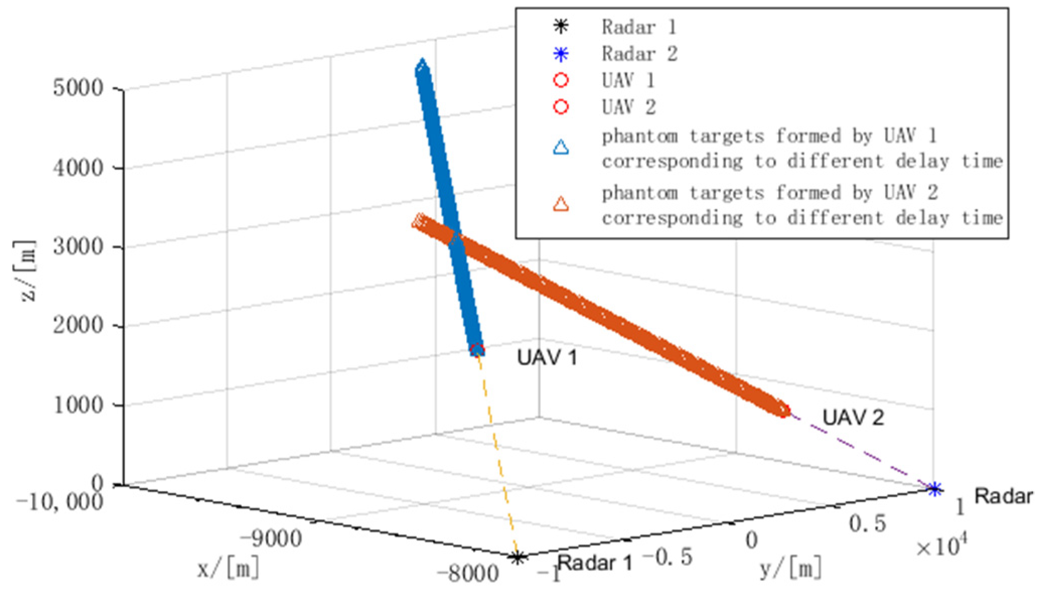
5. Simulation Results

To clarify the influence factors of phantom track deception stated above and the effectiveness of the proposed method in this paper, three parts of the computer simulation are implemented and analyzed. They are the performance analysis of the designed phantom, delay time, and joint phantom track deception and TDOA/FDOA localization, respectively.
The simulation settings are as follows: four radars are located at R 1 = [ 0 , 10 , 0 ] km, R 2 = [ 0 , 10 , 0 ] km, R 3 = [ 15 , 0 , 0 ] km, R 4 = [ 15 , 0 , 0 ] km. The designed phantom track begins at initial point [ 7 , 2 , 3 ] km. The phantom target is in the constant velocity motion at the speed of [ 100 ,   100 ,   10 ] m/s. The initial sensor noises in TDOA and FDOA localization are σ r = 0.15 , σ f = 0.15 , respectively. The initial p i values of UAVs are set as p 1 = 0.6 , p 2 = 0.4 , p 3 = 0.4 , p 4 = 0.5 .

5.1. The Performance Analysis of the Designed Phantom

This section mainly analyzes the influence of the phantom target position on the localization accuracy, which will further affect the deception effect. In Section 3, we discussed optimal UAVs localization for maximizing the determination of FIM. In order to describe the localization accuracy in a specific deployment of sensors, the geometrical dilution of precision (GDOP) is applied in this situation, which can be expressed as:
GDOP = ( J T F ( R t ) ) 1
Two different phantom track points ( T 1 , T 2 ) are chosen in this situation. The positions of these points are T 1 = [ 30 , 12 , 3 ]   km and T 2 = [ 7 , 2 , 3 ]   km , respectively. The p values of each UAV remain unchanged in these cases. The localization accuracy at different phantom track points is shown in Figure 6.
As shown in Figure 6, to realize the designed position of phantom target points, different positions of UAVs are derived, and this causes different localization error distribution. From Figure 6a, when the phantom target point is far away from the radars, the corresponding localization errors of radars are large. In this case, the maximum localization error of radar 4 even reaches 315.44 m, so obviously the success rate of deception mission is low. To enhance the localization performance, the deployments of UAVs are optimized by maximizing the determinant value of FIM during localization. Figure 6b shows the optimized UAV deployment and the corresponding estimation error of radar location. The average estimation error decreases to 30.12 m. Through the comparison between Figure 6a,b, it can be seen that even for the same phantom target point, the localization error can be reduced by deployment optimization using FIM.
Figure 6c shows the localization error distribution when the designed phantom target point T 2 is close to the radars. In this case, the average positioning error of the radar is 30.19 m, which greatly improves the success rate of effective deception.
Comparing Figure 6a with Figure 6b, it can be seen that even with the same initial p value, the corresponding distribution of localization error is different due to different phantom target location. Figure 6d shows the optimized estimation error after applying FIM to optimize UAV deployment, where the average localization error is 13.29 m.
Therefore, the design of the phantom target location has a great impact on the localization accuracy and deception effectiveness. In practical applications, the location of the phantom target should be determined by considering the overall radar distribution, tactical needs and platform constraints.

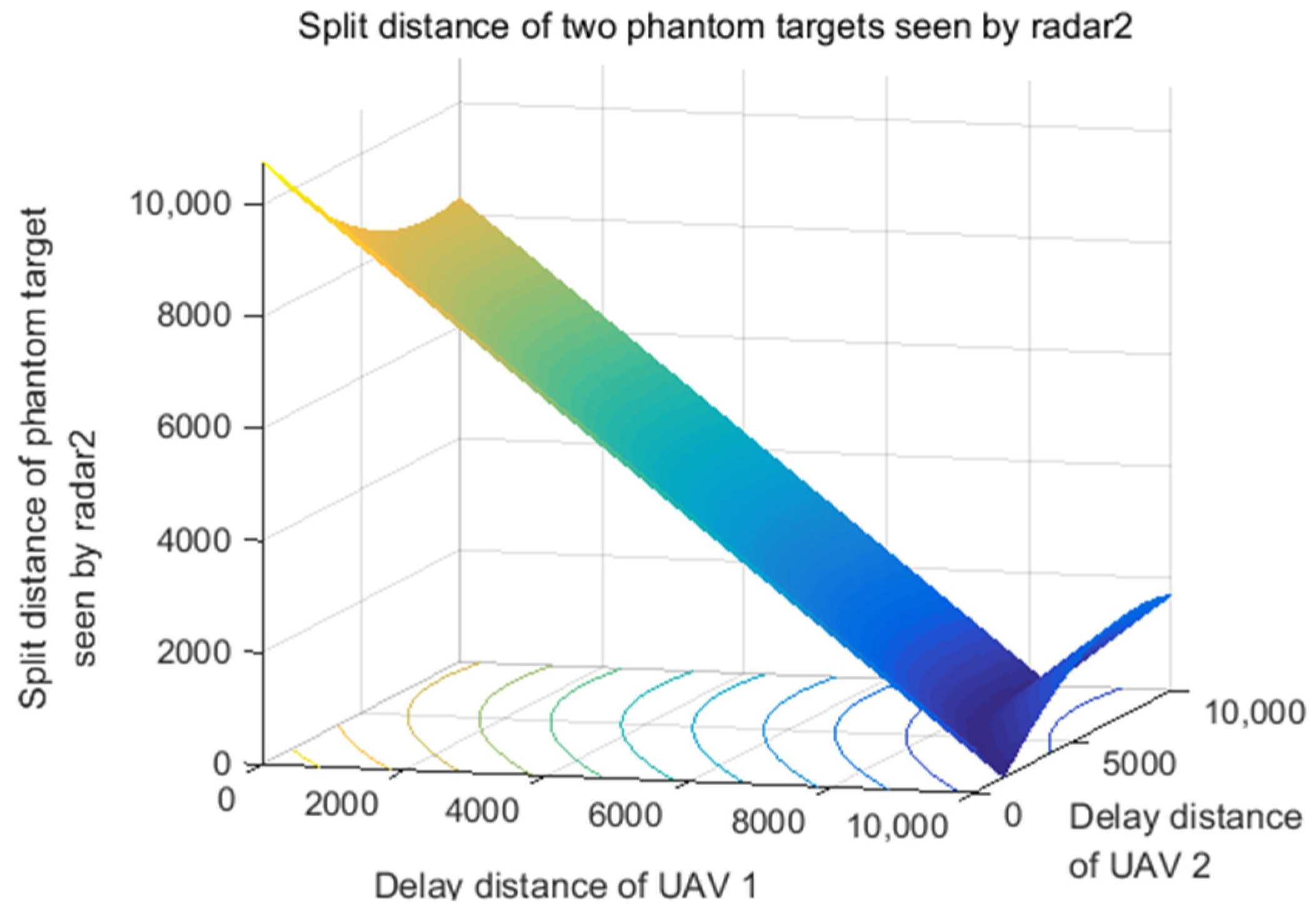
5.2. The Performance Analysis of Delay Distance

The deception range serves as the direct statistic in the same source testing. The performance analysis of delay distance is important in studying the phantom track deception. The simulation results of performance analysis of delay distance are as follows. We take a scenario of two UAVs, deceiving two radars as an example, as shown in Figure 7. When there are multiple radars, two radars with the farthest distance should be selected as the benchmark, and the conclusion is also applicable.
At each flight point, the time delay determines the delay distance of the radar signal. Then, the position of the corresponding phantom target is determined. Two UAVs form two phantom target points in the 3D space, and the split degree of these two phantom targets is calculated by | A R 1 B R 1 | and | A R 2 B R 2 | . Using the same source testing method stated before, the radar network will assess the targets. If the two phantom target points are in the same SRC, they will pass the same source testing and be regarded as a target by the radar network.
The problem is that with different delay distances, the two UAVs need high cooperation to make sure the two phantom target points are in the same SRC. To verify the coupled delay distance strategy, the simulation results of split distance of two phantom targets seen by two radars are shown in Figure 8 and Figure 9, respectively. In this way, the time delay strategy is significant because it influences the effectiveness of phantom track deception, which greatly relies on the split distance of phantom targets seen by radars.
As shown in Figure 10, if and only if the split distance of phantom targets seen by radar 1 and radar 2 is smaller than SRC simultaneously, the deception can pass the same source testing and is regarded as an effective deception. It verifies that the delay time of the two UAVs needs to cooperate with each other and meet the coupling constraints derived above.

5.3. The Performance Analysis of Joint Phantom Track Deception and TDOA/FDOA Localization

Scenario 1: Radar distribution and the designed phantom track are shown in Figure 11. As shown in Figure 12, due to the radar location error and UAV position error, the phantom target points formed by four UAVs are split in the space, surrounding the designed phantom track. If the split is slight, the phantom target points can pass the SRC testing, and then the deception is effective. Otherwise, the radar network can identify and eliminate the phantom target points.
Three radars are located at R 1 [ 0 , 10 , 0 ] , R 2 [ 0 , 10 , 0 ] , R 3 [ 15 , 0 , 0 ] km. The designed phantom track begins at initial point [ 7 , 2 , 3 ] km. The phantom target is in the constant velocity motion at the speed of [ 100 , 100 , 10 ] m/s. The initial p values of UAVs are set as p 1 = 0.6 , p 2 = 0.4 , p 3 = 0.45 . The interval of p values is set as [ 0.2 , 0.9 ] . To form the designed phantom track, the flight trajectory of each UAV can be derived. In other words, the corresponding p value and the time delay of four UAVs can be obtained as shown in Figure 13 and Figure 14.
Table 5 and Table 6 show the pass ratio of same source testing under different radar resolution and different localization error. The pass ratio means the ratio of phantom targets number that can pass the same source testing to the total number of phantom targets. It can be seen that the smaller the localization error is, the bigger the pass ratio is. If there is no localization error, it is a special case which is studied as a phantom track deception with precise locations of radars. In this special case, the pass ratio can rise to nearly 100%, as stated in [18]. Although the pass ratio may reduce under the circumstances without prior knowledge, this situation is more reasonable, which suggests the condition in [18] may be infeasible. In fact, since the experiment results show that the localization error has significant influence, it should not be neglected. This simulation result verifies that localization accuracy greatly influences the effectiveness of phantom track deception. At the same time, the larger the SRC is, the higher the pass ratio is. This simulation result verifies that radar resolution is another important index in deception effectiveness.
Scenario 2: Radar distribution and the designed phantom track are shown in Figure 15. As shown in Figure 16, due to the radar location error and UAV position error, the phantom target points formed by four UAVs are split in the space, surrounding the designed phantom track. If the split is slight, the phantom target points can pass the SRC testing, and then the deception is effective. Otherwise, the radar network can identify and eliminate the phantom target points.
To form the designed phantom track, the flight trajectory of each UAV can be derived. In other words, the corresponding p value and the time delay of four UAVs can be obtained as shown in Figure 17 and Figure 18. The initial p values of UAVs are set as p 1 = 0.3 , p 2 = 0.8 , p 3 = 0.3 , p 4 = 0.4 . The interval of p values is set as [ 0.2 , 0.9 ] .
It can be seen that all the p values are constrained in the interval of [ 0.2 , 0.9 ] which obeyed the initial parameter setting. The time delays of each UAV at each time step adaptively change according to the proposed method to form the designed phantom track.
Table 7 shows the pass ratio of same source testing under different radar resolutions and different localization errors. It can be seen that the smaller the localization error is, the higher the pass ratio is. This simulation result verifies that localization accuracy greatly influences the effectiveness of phantom track deception. At the same time, the larger the SRC is, the higher the pass ratio is. This simulation result verifies that radar resolution is another important index in deception effectiveness. Note that in making a comparison between Table 7 with Table 5 and Table 6, it can be seen that the four UAVs scenario can achieve a higher pass ratio within smaller SRC even with bigger localization error. The reason is the TDOA/FDOA localization performance is better when there are more UAVs. Thus, the space split degree of phan-tom target points generated by each UAV at each time step is smaller, which means the phantom target points are closer to the designed ones. As a result, although the same source testing is stricter in the four UAVs scenario, the effectiveness of deception is better than it is in the three UAVs scenario.
From the simulations above, it can be proved that the joint optimization of TDOA/FDOA localization and phantom track deception using UAV swarm is practicable and effective in the situation where there is no or not sufficient prior knowledge of the hostile radars’ locations. Also, the proposed method has proven its performance in deceiving radar networks in near battlefields. The proposed method can be easily applied in scenarios which need more UAVs, and as the number of UAVs increases, the better localization accuracy can be achieved, which means that the phantom track deception will be closer to the designed goal. Moreover, UAV swarm can use some cooperative tactic to obtain more flexibility in its application.

6. Conclusions

The performance analysis of joint phantom track deception and TDOA/FDOA localization is explored in this paper. Firstly, an explicit solution of FIM using TDOA/FDOA measurements is acquired, which provides guidance for the optimal deployment for localization and phantom track design. Secondly, the SRC rule is applied in the same source testing to evaluate the effectiveness of phantom track deception. Thirdly, the process of localization and the phantom track deception method is proposed to realize the integrated capability of sensing and jamming. Finally, the simulation results validate the performance analysis with different conditions. An extension of this work will focus on the optimization method design on localization and phantom track deception.

Author Contributions

Conceptualization, Y.W. and W.W.; methodology, Y.W. and W.W.; software, W.W. and X.Z.; validation, H.Y. and X.Z.; writing—original draft preparation, Y.W.; writing—review and editing, W.W.; visualization, X.Z. and H.Y.; supervision, L.W.; funding acquisition, L.W. All authors have read and agreed to the published version of the manuscript.

Funding

This research was funded by Lirong Wu, grant number ZD10611.

Conflicts of Interest

The authors declare that they have no conflicts of interest.

References

  1. Clark, B.; Mcnamara, W.; Walton, T. Winning the Invisible War; The Center for Strategic and Budgetary Assessments: Washington, DC, USA, 2019; pp. 1–64. [Google Scholar]
  2. Bai, P.; Wang, Y.B.; Liang, X.L. Overview on phantom track deception against radar network using UAVs. Acta Aeronaut. Astronaut. Sin. 2020, 41, 6–21. [Google Scholar]
  3. Guo, S.F.; Yu, G.W.; Xiong, X. Research on method of track deception jamming based on cooperative control of UAVs. J. Air Force Early Warn. Acad. 2018, 32, 44–54. [Google Scholar]
  4. Purvis, K.B.; Astrom, K.J.; Khammash, M. Estimation and optimal configurations for localization using cooperative UAVs. IEEE Trans. Control Syst. Technol. 2008, 16, 947–958. [Google Scholar] [CrossRef] [Green Version]
  5. Purvis, K.B.; Chandler, P.R.; Pachter, M. Feasible flight paths for cooperative generation of a phantom radar track. J. Guid. Control Dyn. 2006, 29, 653–661. [Google Scholar] [CrossRef] [Green Version]
  6. Pachter, M.; Chandler, P.R.; Purvis, K.B. Multiple radar phantom tracks from cooperating vehicles using range-delay deception. Theory Algorithms Coop. Syst. 2004, 29, 368–390. [Google Scholar]
  7. Pachter, M.; Chandler, P.R.; Larson, R.A.; Purvis, K.B. Concepts for generating coherent radar phantom tracks using cooperating vehicles. In Proceedings of the AIAA Guidance, Navigation, and Control Conference and Exhibit, Providence, RI, USA, 16–19 August 2004. [Google Scholar]
  8. Purvis, K.B.; Astrom, K.J.; Khammash, M. Estimating radar positions using cooperative unmanned air vehicle teams. In Proceedings of the American Control Conference, Portland, OR, USA, 8–10 June 2005. [Google Scholar]
  9. Maithripala, D.; Jayasuriya, S. Feasibility considerations in formation control: Phantom track generation through multi-UAV collaboration. In Proceedings of the IEEE Conference on Decision and Control, Cancun, Mexico, 9–11 December 2008. [Google Scholar]
  10. Maithripala, D.; Jayasuriya, S. Radar deception through phantom track generation. In Proceedings of the American Control Conference, Portland, OR, USA, 8–10 June 2005. [Google Scholar]
  11. Dhananjay, N.; Ghose, D.; Kuduvalli, A. Generation of a class of proportional navigation guided interceptor phantom tracks. J. Guid. Control Dyn. 2015, 38, 2206–2215. [Google Scholar] [CrossRef]
  12. Maithripala, D.; Jayasuriya, S. Phantom track generation in 3D through cooperative control of multiple ECAVs based on geometry. In Proceedings of the First International Conference on Industrial and Information Systems, Tirtayasa, Indonesia, 8–11 August 2006. [Google Scholar]
  13. Lee, I.; Bang, H. A cooperative line-of-sight guidance law for a three-dimensional phantom track generation using unmanned aerial vehicles. Proc. Inst. Mech. Eng. Part G J. Aerosp. Eng. 2012, 6, 897–915. [Google Scholar] [CrossRef]
  14. Lee, I.; Bang, H. Optimal phantom track generation for multiple electronic combat air vehicles. In Proceedings of the International Conference on Control, Automation and Systems, Seoul, Korea, 14–17 October 2008. [Google Scholar]
  15. Lee, I.; Bang, H. Cooperative control of multiple electronic combat air vehicles for electronic attack. In Proceedings of the SICE Conference, Chofu, Japan, 20–22 August 2008. [Google Scholar]
  16. Lee, I.; Bang, H. Phantom track generation using predictive control concept. In Proceedings of the International Conference on Control, Automation and Systems, Gyeonggi, Korea, 26–29 October 2011. [Google Scholar]
  17. Kim, Y.H.; Kim, D.G.; Han, J.W.; Song, K.H.; Kim, H.N. Analysis of sensor-emitter geometry for emitter localisation using TDOA and FDOA measurements. IET Radar Sonar Navig. 2017, 11, 341–349. [Google Scholar] [CrossRef]
  18. Zhao, S.; Liu, Z. Deception parameter estimation and discrimination in distributed multiple-radar architectures. IEEE Sens. J. 2017, 17, 6322–6330. [Google Scholar] [CrossRef]
  19. Liu, X.; Li, D.S. A three-dimensional phantom track generation for radar network deception. IEEE Access 2019, 7, 27288–27301. [Google Scholar] [CrossRef]
  20. Liu, X.; Li, D.S. Deviation compensation for phantom tracks jamming against distributed radar network. Syst. Eng. Electron. 2018, 40, 1255–1264. [Google Scholar]
  21. Wang, G.H.; Yang, Z.; Wu, J.P. Influence analysis of radar location error on multi-aircraft cooperative track deception. J. Nav. Aeronaut. Astronaut. Univ. 2015, 30, 501–510. [Google Scholar]
  22. Shima, T.; Chandler, P.; Pachter, M. Decentralized estimation for cooperative phantom track generation. In Cooperative Systems; Springer: New York, NY, USA, 2007; pp. 339–350. [Google Scholar]
  23. Purvis, K.B.; Chandler, P.R. A review of recent algorithms and a new and improved cooperative control design for generating a phantom track. In Proceedings of the American Control Conference, New York, NY, USA, 11–13 July 2007. [Google Scholar]
  24. Xu, Y.; Basset, G. Virtual motion camouflage based phantom track generation through cooperative electronic combat air vehicles. In Proceedings of the American Control Conference, Baltimore, MD, USA, 30 June–2 July 2010. [Google Scholar]
  25. Ratnoo, A.; Shima, T. Formation-flying guidance for cooperative radar deception. J. Guid. Control Dyn. 2012, 35, 1730–1739. [Google Scholar] [CrossRef]
  26. Dhananjay, N.; Kuduvalli, A.; Ghose, D. Realistic coherent phantom track generation by a group of electronic combat aerial vehicles. In Proceedings of the American Control Conference, Washington, DC, USA, 17–19 June 2013. [Google Scholar]
  27. Hadi, H.; Suhada, J. Guaranteed consensus in radar deception with a phantom track. In Proceedings of the ASME 2013 Dynamic Systems and Control Conference, Palo Alto, CA, USA, 21–23 October 2013. [Google Scholar]
  28. Hatem, H. Optimal sensor velocity configuration for TDOA-FDOA geolocation. IEEE Trans. Signal Process. 2017, 65, 628–637. [Google Scholar]
  29. Wang, W.; Bai, P.; Liang, X.; Zhang, J.; He, L. Performance analysis and path planning for UAVs swarms based on RSS measurements. Aerosp. Sci. Technol. 2018, 8, 157–166. [Google Scholar] [CrossRef] [Green Version]
  30. Lui, W.K.; So, H.C. A study of two-dimensional sensor placement using time-difference-of-arrival measurements. Digit. Signal Process. 2009, 19, 650–659. [Google Scholar] [CrossRef]
Figure 1. Problem analysis of phantom track deception.
Electronics 11 01577 g001
Figure 2. Phantom track model with radar location error and UAV position error.
Electronics 11 01577 g002
Figure 3. Geometry and vector notations for radar location.
Electronics 11 01577 g003
Figure 4. Same source testing of radar network using the SRC rule.
Electronics 11 01577 g004
Figure 5. Process of localization and phantom track deception method.
Electronics 11 01577 g005
Figure 6. The localization accuracy of different phantom track points. (a) Phantom target point is far from radars. (b) Using FIM to optimize UAV deplyment in (a). (c) Phantom target point is close to radars. (d) Using FIM to optimize UAV deplyment in (c).
Electronics 11 01577 g006
Figure 7. The phantom targets formed by two UAVs with different delay times.
Electronics 11 01577 g007
Figure 8. Split distance of two phantom targets seen by radar 1.
Electronics 11 01577 g008
Figure 9. Split distance of two phantom targets seen by radar 2.
Electronics 11 01577 g009
Figure 10. Split distance of phantom targets seen by radar 1 and radar 2.
Electronics 11 01577 g010
Figure 11. Ideal phantom track deception by three UAVs against three radars.
Electronics 11 01577 g011
Figure 12. Phantom deception with radar location error and UAV position error (three UAVs).
Electronics 11 01577 g012
Figure 13. P value of three UAVs.
Electronics 11 01577 g013
Figure 14. Delay distance of three UAVs.
Electronics 11 01577 g014
Figure 15. Ideal phantom track deception by four UAVs against four radars.
Electronics 11 01577 g015
Figure 16. Phantom deception with radar location error and UAV position error (four UAVs).
Electronics 11 01577 g016
Figure 17. p Value of four UAVs.
Electronics 11 01577 g017
Figure 18. Time delay of four UAVs.
Electronics 11 01577 g018
Table 1. Related work by US scholars.
ReferenceType of ErrorScenarioTesting RuleMethod
[7]---2Dmajority-rule schemeClosed form solutions are obtained for the ECAV trajectory given a specified phantom track.
[22]---2D---A decentralized estimation-decision strategy is derived for a team of electronic combat air vehicles (ECAVs) deceiving a network of radars.
[8]TDOA localization error2Dminimum variance estimation theoryA nonlinear system model for estimation is formulated and used to perform simulations with “noisy” TDOAs; a linearized time-varying model for straight nominal ECAV trajectories is derived from the nonlinear model
[5]UAV position error2D---Generalized bounds for the initial conditions and time-dependent flyable ranges of a team of ECAVs are presented
[23]UAV position error2D---Generalized bounds for the initial conditions and time-dependent flyable ranges of a team of ECAVs are presented
[6]UAV kinetic limit, wind influence2D---Optimal control and then either (1) adding smooth penalty functions to the cost, or (2) using control parametrization.
[11]TDOA localization error2D---Analyzing the explicit solution leads to The Angle Rule, analyzing the Fisher Information Matrix leads to the Coordinate Rule
[24]---3D---virtual motion camouflage based (VMC) subspace optimal trajectory design method
[25]---2D---A generalized kinematic framework for the required formation. Flying is developed from the principles of line-of-sight guidance.
Table 2. Related work by Korean scholars.
ReferenceType of ErrorScenarioTesting RuleMethod
[13]---3D---A guidance law based on input–output feedback linearization is developed. A closed-form solution is constructed for the unmanned aerial vehicles trajectory corresponding to the pre-specified phantom track
[17]TDOA/FDOA localization error2D---FIM
[14]---3Doptimal control problem with dynamic equation and constrainsC code for Feasible Sequential Quadratic Programming (CFSQP)
[15]---3Dthe trajectory generation problem is formulated as an optimal control problemThe parameter optimization problem with inequality constraints using the sequential quadratic programming method
[16]---3D---line of sight (LOS) guidance based on predictive controller
Table 3. Related work by Indian scholars.
ReferenceType of ErrorScenarioTesting RuleMethod
[9]---2D---Distributed control architecture.
[10]---2D---Translate kinematic constraints on the ECAV dynamic system into constraints on the phantom point
[11]---2D &3D---sufficient conditions for the existence of feasible ECAV trajectories are first obtained in a planar engagement scenario and then extended to the more general three-dimensional framework
[12]---3D---The trajectory of a ECAV can be represented by a parameterized differentiable space curve in R3 and capture ECAV actuator constraints through constraints on speed, curvature and torsion of this space curve
[26]UAV position error2DThe Performance Measure |P1−P2|The phantom track considered is the trajectory of a missile guided by proportional navigation. The line-of-sight guidance law is used to control the ECAVs for practical implementation
[27]---2D---A motion planning algorithm provides some conditions on configuration parameters and the desired trajectory such that the proposed control guarantees consensus
Table 4. Related work by Chinese scholars.
ReferenceType of ErrorScenarioTesting RuleMethod
[18]---2DSpace resolution cell (SRC)The effective range of time delay is derived under the condition of near field and far field
[19]localization error/UAV position error3DN/M ruleThe beam rider guidance method is used to compensate the track deviation
[20]---3DNearest neighbor method and bearings-only associations methodMultiple discriminations for multi-range-false–target
[21]localization error/UAV position error3DN/M ruleThe deviation compensation for phantom tracks and the tracks’ association detection are presented
[24]UAV position error2DK-NN track correlationThe correlative model is deduced
Table 5. The pass ratio of the same source testing under different radar resolution and different localization error (unit of pass ratio: %).
Space Resolution Cell δ 1 20304050607080
Localization Error
σ t = 0.075 σ f = 0.15 68.3287.2691.4794.0094.5394.7494.74
σ f = 0.15 σ t = 0.075 41.4758.7469.3785.2688.2192.7492.80
σ t = 0.15 σ f = 0.3 38.4254.8473.2683.1689.4790.8891.05
σ f = 0.15 σ t = 0.15 28.6345.2668.5381.4785.5889.0591.05
σ t = 0.3 σ f = 0.3 67.5884.1191.0093.1694.2194.6394.74
σ f = 0.15 σ t = 0.3 65.4783.5390.7892.8494.1394.5394.74
σ t = 0.45 σ f = 0.3 64.8480.6390.4292.0094.0094.5394.74
Table 6. The pass ratio of same source testing under different radar resolution and different localization error (unit of pass ratio: %).
Space Resolution Cell δ 1 20304050607080
Localization Error
σ t = 0.15 σ t = 0.3 42.1663.0573.4782.2190.1192.8493.47
σ f = 0.075 σ f = 0.075 41.4758.7469.3780.2688.2192.7492.80
σ t = 0.15 σ t = 0.3 35.5850.6366.8477.8987.6890.9591.05
σ f = 0.15 σ f = 0.15 35.4760.6369.5878.7488.5390.7492.00
σ t = 0.15 σ t = 0.3 38.4254.8473.2683.1689.4790.8891.05
σ f = 0.225 σ f = 0.225 34.8456.4269.4779.8983.3789.4791.32
Table 7. The pass ratio of same source testing under different radar resolution and different localization error (unit of pass ratio: %).
Space Resolution Cell δ 1 13571015
Localization Error
σ t = 0.15 σ f = 0.15 36.596.6798.2098.3398.3398.33
σ f = 0.15 σ t = 0.3 6.6778.3995.1797.8398.2898.33
σ t = 0.3 σ f = 0.225 6.1175.9494.1197.7898.2898.33
Publisher’s Note: MDPI stays neutral with regard to jurisdictional claims in published maps and institutional affiliations.

