Article

Efficient Route Planning Using Temporal Reliance of Link Quality for Highway IoV Traffic Environment

1
School of Computer & Systems Sciences, Jawaharlal Nehru University, New Delhi 110067, India
2
School of Computing Science & Engineering, Galgotias University, Greater Noida 203201, India
3
Department of Computer Science, Nottingham Trent University, Clifton Lane, Nottingham NG11 8NS, UK
4
Department of Computer Science, Faculty of Information Technology, Zarqa University, Zarqa 13110, Jordan
5
Department of Communications, Universitat Politecnica de Valencia, Camino Vera s/n, 46022 Valencia, Spain
*
Author to whom correspondence should be addressed.
Electronics 2023, 12(1), 130; https://doi.org/10.3390/electronics12010130
Submission received: 19 November 2022 / Revised: 19 December 2022 / Accepted: 23 December 2022 / Published: 28 December 2022
(This article belongs to the Special Issue Intelligent Technologies for Vehicular Networks)

Abstract

:
Intermittently connected vehicular networks, terrain of the highway, and high mobility of the vehicles are the main critical constraints of highway IoV (Internet of Vehicles) traffic environment. These cause GPS outage problem and the existence of short-lived wireless mobile links that reduce the performance of designed routing approaches. Nevertheless, geographic routing has attracted a lot of attention from researchers as a potential means of accurate and efficient information delivery. Various distance-based routing protocols have been proposed in the literature, with an emphasis on restricting the forwarding area to the next forwarding vehicle. Many of these protocols have issues with significant one-hop link disconnection, long end-to-end delays, and low throughput even at normal vehicle speeds in high-vehicular-density environments due to frequently interrupted wireless links. In this paper, an efficient geocast routing (EGR) approach for highway IoV–traffic environment considering the shadowing fading condition is proposed. In EGR, a geometrical localization for GPS outage problem and a temporal link quality estimation model considering underlying vehicular movement have been proposed. Geocast routing to select a next forwarding vehicle from forward region by utilizing temporal link quality is proposed for four different scenarios. To evaluate the effectiveness and scalability of EGR, a comparative performance evaluation based on simulations has been performed. It is clear from the analysis of the results that EGR performs better than state-of-the-art approaches in highway traffic environment in terms of handling the problem of wireless communication link breakage and throughput, as well as ensuring the faster delivery of the messages.

1. Introduction

The vehicular ad hoc network (VANET), which connects vehicles to pedestrians, parking areas, roadside equipment, and city infrastructure, is being augmented by the notion of the Internet of Vehicles (IoV) [1]. IoV incorporates many significant Internet of Things elements to deliver a wide range of new services that are beneficial to people and society. IoV vehicles are great things that work together to share information and communicate with one another via the Internet. Data dissemination, traffic management, cost administrations, and location-based services are all important IoV applications. The provision of connected vehicles to prevent accidents, lower vehicle assemblage when partnering accidents, and offer alarms related to street and crossing point status is one of the most crucial applications of IoV. Underlying VANETs are now essential for offering entertainment and safety applications due to the co-evolution of standards like IEEE 802.11p and IEEE 1609 that facilitate Wireless Access in a Vehicular Environment (WAVE) [2]. The major characteristics that set it apart from other mobile ad hoc network are its high vehicle speed, dynamic mobility, and random topology.
The most notable characteristic of VANETs is the high node mobility, which underlies a number of VANET-specific characteristics that demand the provision of appropriate solutions [3,4]. All mobile networks have the inherent property of temporal connectivity caused by node mobility, which is much more apparent in the case of vehicular communications. Due to frequent communication link breakdowns between vehicles and poor performance, this poses serious issues. The topology continuously changes in a number of ways. In more detail, these issues make designing routing for VANETs very complex [5]. The changing aspects involved suggest that the actual connectivity abilities change quickly, so gathered routing data quickly become outdated and the formed communication routes quickly become invalid. Route reconstruction requires a huge amount of network resources, and the consequent interruption of information flow results in significant delays. Link quality has been accepted as a crucial performance component for VANETs by recent study. The frequency of route reconstructions will increase if the established routes are transient. There is no assurance that the new route will not break as soon as possible after it is established, leading to a series of subsequent route reconstructions. Authors addressed this issue in [6], suggested that VANETs have a relatively small network diameter due to the fact that many routes break down before they can be used. Authors in [7] suggest using the dissemination of GPS information to determine the desired link life span and to illustrate substantial performance improvement when the routing method tentatively involves link quality into consideration. This is important because it allows for the construction of long-lived routes and mitigates the occurrence of frequent communication interruptions.
In recent times, location-oriented vehicular communication, also referred to as geocasting, has attracted a lot of attention due to the fact that it may be applied to a wide variety of ITS applications [6]. The location of vehicles as determined by GPS has been put to use in a number of different applications, including the measurement of the prediction of collisions at intersections [7], vehicle density on roadways [8], and the determination of the location of roadside units [9]. When using GPS to localize a vehicle, one must implicitly assume the non-disruptive availability of the GPS signal of acceptable quality for information dissemination in VANETs [10]. Due to increasing urbanization, including high-rise structures, multi-level flyovers, and highway bridges, GPS outages are becoming a significant challenge [11]. If a vehicle experiences a GPS outage in a specific highway traffic environment, how can other vehicles in the same environment determine its GPS location? As a result, if the sending vehicle experiences GPS outage, its neighboring vehicles will also experience GPS outage [12]. To address this problem, we present a geometrical localization technique in this paper.
Geographic forwarding protocols choose the shortest path, which could result in a greater packet error rate due to the poor quality of a link. The unequal distribution of vehicles on the highways makes it more difficult to select a route; for example, the shortest path in terms of geographic distance may experience more frequent path disconnections even though it is the shortest path. It is possible for there to be frequent communication disconnections between vehicles due to the dynamic and fast changing topology of vehicular networks [13]. There are a number of geographic routing protocols available that are based on GPS location or geography and quality of one link connection [13,14,15,16,17]. Junction-based Geographic Distance Routing (J-GEDIR) [13] using greedy forwarding with a bias toward the node closest to the destination at a junction is suggested. Peripheral-node-based Geographic Distance Routing (P-GEDIR) [14] is proposed to select the next forwarding vehicle from a forwarding region. An important part of the P-GEDIR is the idea of a “peripheral node,” or a node far from the sender that is selected by the next forwarding node. The next forwarding vehicle in the Voronoi region approaching the destination is chosen using Voronoi-diagram-based Geographic Distance Routing (V-GEDIR) [15]. In P-GEDIR, the border nodes are chosen as the next forwarding vehicle, and the coverage area is partitioned vertically toward the destination. These protocols [13,14,15] result in a minimal number of next forwarding vehicles being selected since they limit the size of the forwarding zone. They begin to work poorly if there are many vehicles in the congested reduced forwarding area. In addition, these protocols choose a next forwarding vehicle at the border to reduce the overall hop count. But because of their greater speed, transmission problems are more likely to occur in border vehicles. The quality of a hop connection link is significantly diminished by nearby impediments in the highway traffic setting, such as buildings and trees. All the above mentioned protocols disregarded this factor. To the best of our knowledge, a routing technique has not been developed considering specific connection links that proactively adapt to a topology that is continually changing due to vehicle mobility; instead, it has only used physical-layer-related information to provide criteria for the selection of the next forwarding vehicle.
In this context, efficient geocast routing using the temporal dependence of link quality for highway IoV–traffic environment is proposed. More specifically, a highway traffic mobility model to find locations of the vehicles where GPS outage problem occurred and a temporal link quality estimation model are used to assist the EGR to select the next forwarding vehicle from the forwarding region. An analytical framework that measures the probability of precisely selecting the longest-lasting link among a set of specified links between a sending vehicle and its neighboring vehicles is presented. The main contribution of the paper is listed as follows:
(1)
Firstly, geometrical localization for GPS outage is presented to know the GPS locations of the vehicles.
(2)
Secondly, a temporal link quality estimation model is proposed to capture the tendency of future link quality and residual link lifetime for the underlying structure for the vehicular traffic mobility model for highways.
(3)
Thirdly, a new kind of geocast routing is proposed using geometrical localization, temporal transmission probability, and residual link lifetime under shadowing fading condition for a highway traffic environment.
(4)
Finally, to show the benefit of the proposed routing, a comparison is made with state-of-the-art works in terms of one-hop link disconnection, throughput, and delay.
The remainder of this paper is organized in the following manner. The most recent geocast routing methods used in VANETs are reviewed in Section 2. The proposed EGR approach for a highway traffic environment is presented in Section 3. Section 4 presents the simulation’s results. The conclusion and future work are explained in Section 5.

2. Related Work

This section provides a review of geocast routing protocols. Link quality is considered one of the key factors in geocast routing that has a substantial impact on the performance of these routing approaches. We categorize the existing geocast routing approaches into two subsections based on link quality.

2.1. GPS-Location-Based Geocast Routing without Link Quality

Based on the geographical information of indented vehicles for packet dispersal, a hybrid flooding technique has been proposed [18]. In dynamic vehicular settings, with the exception of those with a higher node density, a hybrid technique that was created by combining the position-aware technique with the counter-based technique improves message dependability. Two forwarding algorithms are used in CTRC-based geographic routing: area sending for hop-to-multihop information transmission and line forwarding for hop-to-hop information transmission [19]. The transmission range is decreased with range forwarding. Because of this, the impact of dynamic mobility patterns and vehicle node speeds on the ratio of data delivery is considerably diminished. Additionally, the hop count is greatly increased. It has been proposed that border node most forward within a radius can decrease end-to-end delay in VANETs [20]. The ideal route with the highest chance of connecting to the network is selected using connectivity-aware routing (CAR) [21], which is derived by a probabilistic model employing information from statistical traffic statistics. However, connectivity may be impacted by the node density calculation’s error. In [22], the accuracy of CAR was significantly enhanced. Using real-time node density data produced by an on-the-fly density collection approach, the best link connection for the route is identified in this study. These studies mentioned above overlook the analysis of connectivity while taking junction nodes into account. Cache is utilized in Cache-Agent-based Geocast (CAG) routing in [23] to solve the packet reject issue. A connectivity assertion mechanism was put forth in CAG to guarantee that the cached packet would not be deleted. It is woefully inadequate to only take into account node density when evaluating connectivity in geocast routing. Because, despite the high node density in urban VANETs, communication can be disrupted in some circumstances due to the presence of traffic signals. Junction-based Geographic Distance Routing (J-GEDIR) [14] and peripheral-node-based Geographic Distance Routing (P-GEDIR) [15] are the two most popular and recent geographic routing protocols. The next hop cars are chosen by J-GEDIR in junction nodes within the transmission range. P-GEDIR chooses all border nodes as next-hop vehicles from the half-circular section moving toward the destination after vertically dividing the circular coverage zone into two half-circular portions. By reducing the forwarding region’s size, these protocols can choose fewer next-hop vehicles.
All of the aforementioned geocast routing approaches considered either flooding techniques or vehicle density for routing purposes. The flooding in multi-hop routing contribute to an increase in network overheads. In addition, these routing approaches often experienced high path disconnection, and their efficiency began to degrade with increasing vehicle speed, making them unsuitable for high traffic environments. In highway, the quality of the link is severely affected by the obstacles of the surrounding, which can include buildings, trees, and other natural features. These protocols and its alternative neglected to take this factor into account.

2.2. GPS-Location-Based Geocast Routing with Link Quality

The impact of radio channel propagation, such as noise, fading, shadowing, etc. on one-hop link connection is one of the crucial issues to consider while studying geocast routing in VANETs. An approach for geocasting [24] in VANETs that uses multiple metrics to choose the next-hop vehicle has been proposed by the authors. The suggested technique makes use of metrics that are based on links and vehicle density to search a reliable next forwarding vehicle for message dissemination in the geocast region. Intermittent Geocast Routing (IGR) [25] in urban VDTNs with storage-carry-forward mode. The IGR operates in two modes: intersection mode and road segment mode. In the intersection mode, the network connectivity characteristic is studied to determine the probability of connectedness for any road segment. In the following hop, the maximum connected road stretch is chosen. Then, on the selected road segment, the vehicular nodes estimate the effective connection interval based on the real road and vehicle circumstances.
To enhance the geographical routing strategy over VANET, a prediction-based geographical routing (PGR) approach is suggested using link quality measure. It reconsidered the forwarding and repair procedures of the routing approach given in [26]. R. Kasana et al. [27] performed an analysis of the precision of the location information of vehicles, which is dependent on the effectiveness and scalability of geographical routing. Through the use of GPS or other positioning technologies, the vehicle is able to control its own location. The geographical routing takes into consideration the precise location information implicitly. However, taking into account the GPS’s accuracy limitations and the fact that signals might be blocked by the environments along roadways, this assumption is not reasonable. The erroneous location information is the root cause of the performance issues that occur as a result of using geographical routing methods. Specifically, Oliveira et al. [28]. demonstrate that inaccuracies in location during geographic routing (in wireless sensor networks) can lead to poor performance or even total failures. In geographic routing, it is necessary for each node to have information regarding its present position, which can be obtained by the use of GPS or another type of localization technique (Qureshi et al. [29]). In wireless sensor networks, one of the most crucial tasks to complete is the installation of a localization system. As a result of the geographic correlation of the sensed data, location information is frequently used to name the obtained data, address nodes, and regions and also to improve the performance of a wide variety of geographic algorithms. GPS-location-based Link quality and Degree of connectivity based Geographic Distance Routing (SLD-GEDIR) [17] is proposed, selecting the most dependable forwarding vehicle by taking into consideration one-hop link quality.
Nevertheless, the aforementioned routing approaches do not take into account dynamic vehicles movement patterns while considering one-hop link quality as one of the routing metrics, and these routing approaches are not suitable under a vehicular network scenario with intermittent connectivity under sparse vehicular networks and where GPS outages occur. However, in a VANETs scenario, the network delay and overhead increase as these protocols use more routing metrics, which in turn comes with higher process complexities.

3. The Proposed EGR Approach for Highway Traffic Environment

In this section, first, we present geometrical localization for GPS outage and the temporal locations of the moving vehicles that are facing GPS outage problem and its environment on a highway. Second, the residual link lifetime estimation model to capture the tendency of future link quality and predict the future lifetime of the link between vehicles is presented. Last, the proposed geocast routing, both geometrical localization and link quality for a highway traffic environment, is presented.

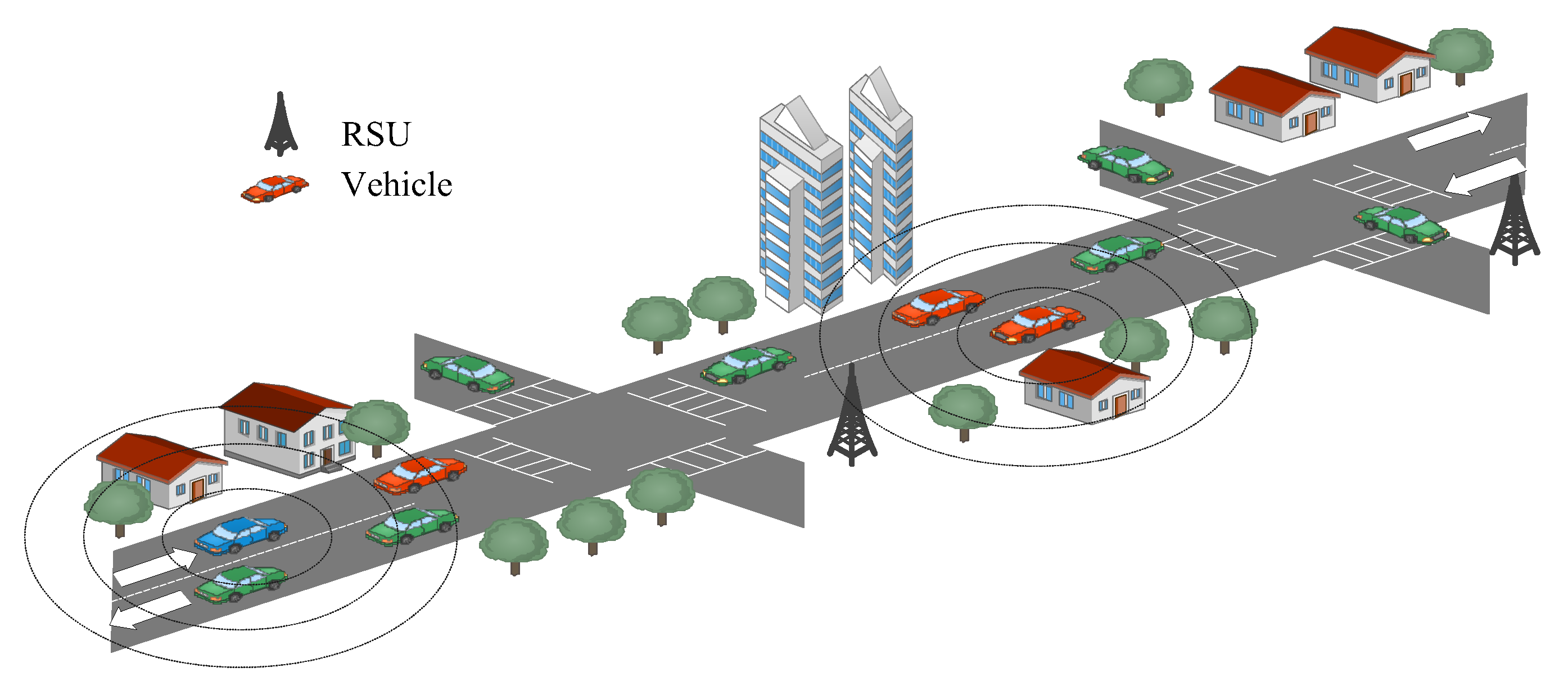
3.1. Highway Traffic Environment

Consider a highways environment where each road intersects the others at a right angle; this intersection is known as a junction point (see Figure 1). There are road side units (RSUs) to assist the transmission of the messages at every intersection. To ascertain the geographical properties of moving vehicles, GPS location service equipment is integrated into every vehicle. Each vehicle should have an onboard navigation system to pinpoint the precise location of the closest traffic intersections. Dedicated short-range communication (DSRC) is utilized to optimize the communicational pattern. We further suppose that the network area consists of a large number of virtual junctions. Due to the lack of next-hop vehicles that can send the packets to their destinations, the sender vehicles hold the forwarded packets in their caches. The buildings and trees are located in the side of the highway, and the highways pass through different types of terrain. The shadowing fading is considered that hinders the quality of links between the vehicles due to the presence of trees and buildings on the sides of the highway and the terrain types of the highway. In addition, increasing urbanization leads to GPS outage problem.

3.2. Geometrical Localization for GPS Outage

The majority of the GPS-assisted localization algorithms assume the availability of a sufficient number of location-aware neighboring vehicles for the purpose of routing. In a realistic highway traffic environment, the assumption, which include GPS-capable surrounding vehicles is not feasible for routing purposes. When a vehicle’s GPS signal is blocked in certain highway traffic environments, how are its neighbors in those environments supposed to know where they are relative to their own GPS signals? To solve this problem, we present geometrical localization to compute the locations of moving vehicles that are facing a GPS outage problem.
Every vehicle is capable of measuring speed, direction, and time with a degree of precision that is adequate. In the event that the GPS in a vehicle fails to work, an EGR system will allow the vehicle to estimate its location using geometrical localization. We consider two vehicles N i and N j that are moving on a straight road segment (see Figure 2). The maximum transmission radius of a vehicle in a perfect environment is assumed to be R . Its values for different types of vehicles is not equal. Let ( x i , y i ) and ( x j , y j ) represent the position of the vehicles N i and N j at time t respectively. In addition, let v i and v j represent the velocity of the vehicles and the direction of movement for both the vehicles N i and N j are θ i and θ j respectively. After a short while, if the vehicle experiences a GPS outage issue on the same road segment, the unknown position vectors of the vehicles N i and N j at time t are ( x i , y i ) and ( x j , y j ) , respectively, and the movement direction and velocities for both vehicles may change when needed. Using the geometrical rule, the unknown positions of the vehicles in case of GPS outage can calculated as follows. The position for both the vehicles at time t can be expressed as
  x k = x k +   v k ( t t   ) cos θ k   y k = y k +   v k ( t t   ) sin θ k }
where k = { i ,   j } . The temporal distance between both vehicles at time t can be expressed
d ( t ) = ( Δ x + Δ v Δ t Δ cos θ ) 2 + ( Δ y + Δ v Δ t Δ sin θ ) 2
where Δ x = ( x i x j ) , Δ v = ( v i v j ) , Δ cos θ = ( cos θ i cos θ j   ) , Δ sin θ = ( sin θ i sin θ j ) , and Δ t = ( t t ) .

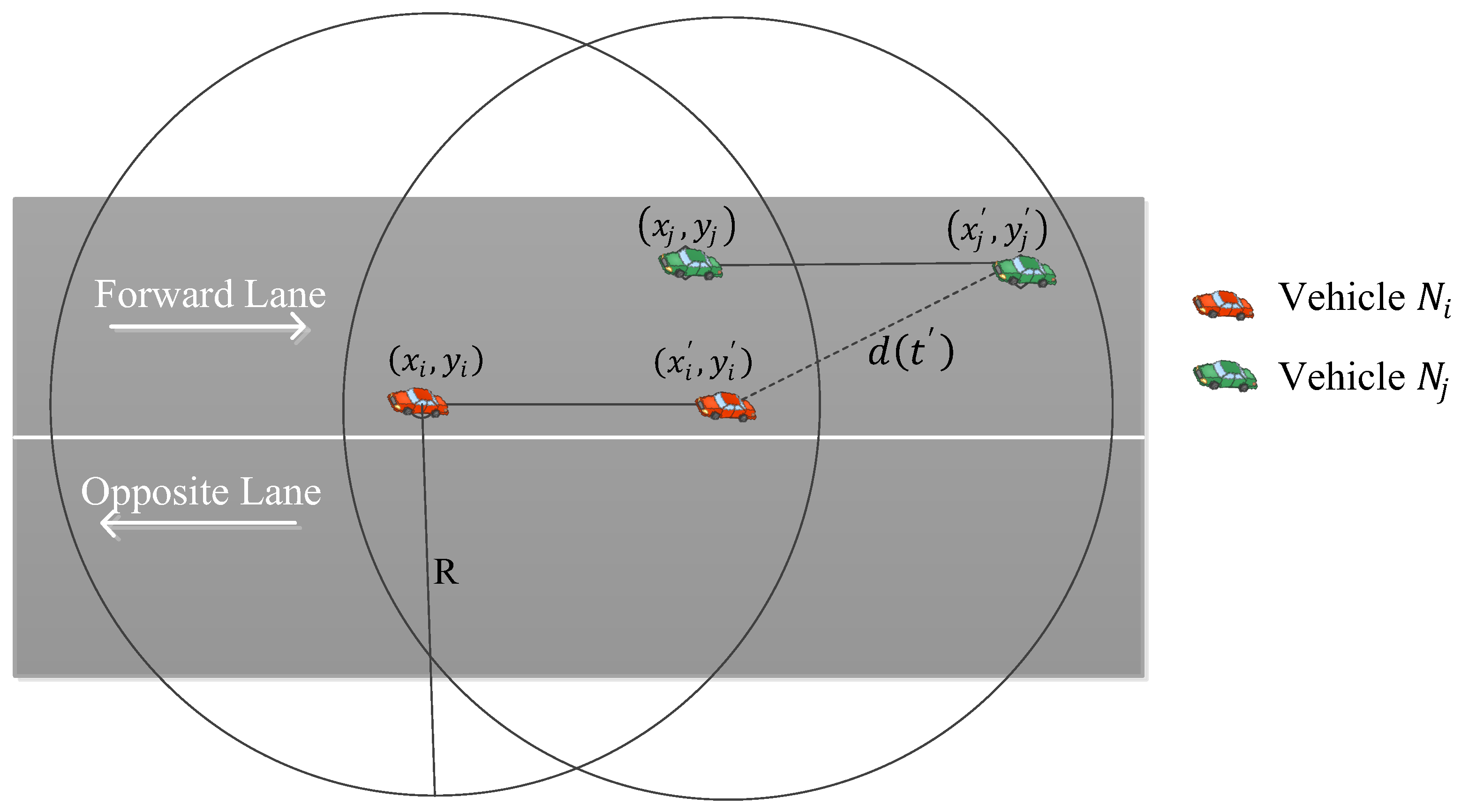
3.3. Temporal Link Quality Estimation Model

In this section, we first calculate the link quality (temporal transmission probability) of each radio link between a sending vehicles and its neighboring vehicles that are moving in the same direction. Second, we estimate the remaining link lifetime of a specified link between a sending vehicle and its neighboring vehicles.
(a)
Temporal Transmission Probability
We assume that there exists a sending vehicle N i and a receiving vehicle N j in the transmission range of the sender. Since the radio transmission range is affected by natural phenomena such as shadowing, multipath fading, noise, etc.; thus, the vehicle’s radio transmission range is considered to be non-uniform in all directions. In the proposed model, we considered only the shadowing fading which is occurring due to the presence of some large transport vehicles or any other obstruction between vehicles N i and N j . Let vehicle N i wish to send some packets to the neighboring vehicle N j . The temporal received power P j , R ( d ( t ) ) at vehicle N j at time t using (2) can be expressed as
P j , R   ( d ( t ) ) = P i , T P ¯ ( d 0 ) 10 η l o g 10 ( ( Δ x + Δ v Δ t cos θ ) 2 + ( Δ y + Δ v Δ t sin θ ) 2 d 0 ) + χ σ
where P i , T denotes the transmit power of the vehicle N i ; P ¯ ( d 0 ) denotes the mean path loss at reference distance d 0 , where the reference distance is generally assumed to be one; η is the path loss factor depending on the condition of the environment. The χ σ denotes different levels of cutter in the received power due to shadowing fading, and it is assumed to be a Gaussian random variable with zero mean and σ 2 variance. The received threshold power of the vehicle N j with the maximum transmission range R in a perfect environment can be expressed as
P j , R   ( R ) = P i , T P ¯ ( d 0 ) 10 η l o g 10 ( R d 0 )
The probability of successful transmission P i , j ( d ( t ) ) between the sending vehicle N i and the receiving vehicle N j at time t can be expressed as
P i , j ( d ( t ) ) = P ( P j , R   ( d ( t ) ) > P j , R   ( R ) )
= P (   χ σ > 10 η l o g 10 ( ( Δ x + Δ v Δ t Δ cos θ ) 2 + ( Δ y + Δ v Δ t Δ sin θ ) 2 R ) )
where P ( . ) represents the probability function. The temporal transmission probability is given by
P i , j ( d ( t ) ) = 10 η l o g 10 ( ( Δ x + Δ v Δ t Δ cos θ ) 2 + ( Δ y + Δ v Δ t Δ sin θ ) 2 R ) σ 1 2 π   σ e x 2 2 σ 2   d x
= Q ( 10 η l o g 10 ( ( Δ x + Δ v Δ t Δ cos θ ) 2 + ( Δ y + Δ v Δ t Δ sin θ ) 2 R ) σ )
where Q ( u ) = u 1 2 π e t 2 2   d t , which evaluates the tail probability of Gaussian distribution.
(b)
The Residual Link-Lifetime
When using the distant vehicle for the purpose of routing, the measuring of the performance of the proposed routing does not achieve accuracy; thus, correctly finding a link between the sending vehicle and distant vehicles that will last longer is the purpose of this section. The residual link lifetime is the forthcoming time period in which the link remains active. The purpose of estimating the residual link lifetime during which an existing link between moving vehicles will continue to function properly under shadowing fading and to demonstrate how such a technique may be incorporated into a routing approach to achieve the required aim of the guaranteed delivery of the message with geocast routing for a highway traffic environment with links experiencing the adverse effect of shadowing fading. Let two vehicles N i and N j be connected at a time t . The forthcoming temporal distance for both the vehicles remaining connected is R d ( t ) . The uncertainty in the link-lifetime estimates can be introduced by temporal transmission probability P i , j ( d ( t ) ) , which represents variation in the link. The residual link-lifetime ( T l l ) can be computed as
T l l = R d ( t ) | Δ v | P i , j ( d ( t ) )

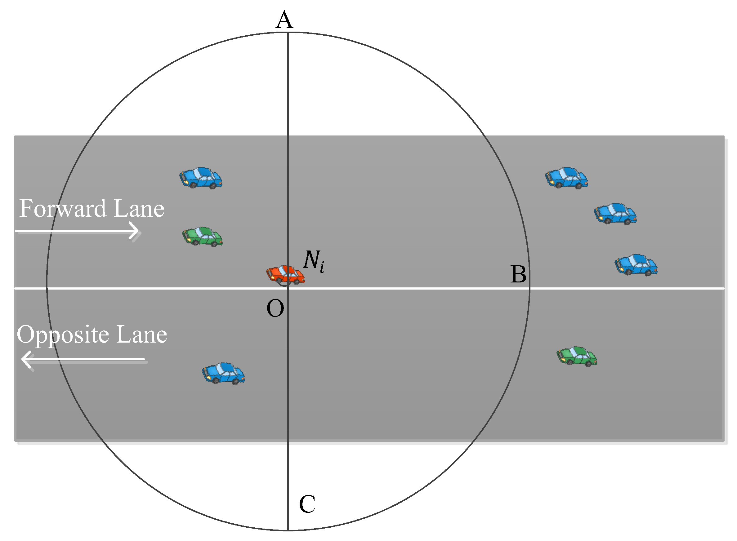
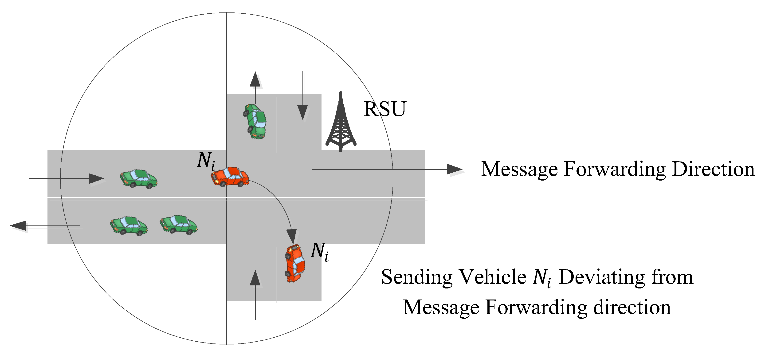
3.4. Geocast Routing

A description of the routing process of the proposed protocol is explained in this section. In a highway IoV traffic environment, the vehicles are intermittently connected and they show high-speed vehicle mobility. In addition, natural phenomena, such as shadowing fading, influence connectivity. These constraints make the routing a challenging task in a highway traffic environment. All of the individual links that make up the route for hop-by-hop message forwarding must remain accessible for the duration of the remaining link lifetime. Due to the special characteristics of the highway, we are forced to incorporate residual link lifetime and caching methodology into the proposed EGR.
Considering these critical issues, we present the route construction approach using a scenario depicted in Figure 3 in which a sending vehicle N i estimates the temporal residual link-lifetime using Equation (9) for each vehicle N j moving in a forward direction and are in the forward transmission region AOB (FTA) and transmission ranges of sending vehicle N i . Herein, we define two useful functions argmax(U) and argmin(U) that are used in the following section.
Definition 1.
argmax(U) is the set of neighburing vehicles belonging in a FTA for which U attains the maximum value.
Definition 2.
argmin(U) is the set of neighboring vehicles belonging in a FTA for which U attains the minimum value.
Case 1: When vehicles present in FTA of forward lane
Let t t x , t p r , and t p o denote the transmission time of a packet on the link, the propagation time of the packet that travels via the link from the locations ( x i , y i ) and ( x j , y j ) of the vehicle   N i and vehicle N j at time t , and the processing time of the packet at the receiving vehicle. Each packet is acknowledged to confirm its guaranteed delivery. The round trip time t r t , in which a packet delivered successfully is the sum of transmission time, twice the propagation time, and the processing time. It can be given by
t r t = t t x + 2 × t p r + t p o
For routing purpose, the sending vehicle   N i chooses a vehicle N j among neighboring vehicles that lay in its forward region that should satisfy the following condition:
  • The residual link lifetime T l l of the radio link between both the vehicles is greater than the round trip time t r t .
  • The temporal distance between the sending vehicle   N i and vehicle N j should be high.
When the sending vehicle obtains temporal residual link-lifetime and temporal distance information about its neighboring vehicles, the sending vehicle N i selects a neighboring vehicle with maximum d ( t ) as the next forwarding vehicle such that
  N j = a r g m a x ( d ( t ) × P i , j ( d ( t ) ) ) s t .   T l l t r t > 0                 }
where, herein, a vehicle with a maximum value of d ( t ) × P i , j ( d ( t ) ) is retuned by the argmax() function. Choosing a vehicle N i and N j using the above logic gives a radio link between moving vehicles that will continue to be useful for satisfactory packet transmission.
Case 2: When vehicles present in FTA in the opposite lane
Opposite-lane vehicles are also considered to participate in the routing process, as they can reduce the delay. This is done by a source vehicle that transmits packets to a relay vehicle that is part of its transmission range and which is moving in a backward direction relative to the sending vehicle. As shown in Figure 4, for routing purposes, the sending vehicle N i did not find any neighboring vehicles in its forward transmission region AOB. In such a situation, it selects a vehicle N i + 1 that belongs to the forward region BOC of the opposite lane and a vehicle N i + 1 that has at least one neighboring vehicle   N j that is moving in a forward lane towards the destination. The round trip time in this case is equal to 2 t r t .
For routing purpose, the sending vehicle   N i chooses a vehicle N i + 1 among neighboring vehicles that are moving in the opposite lane and that should satisfy the following condition:
  • The product of the temporal distance and temporal transmission probability between the sending vehicle   N i and vehicle N i + 1 should be high.
  • The vehicle N i + 1 has at least one neighboring vehicle that is moving in a forward lane.
The sending vehicle N i selects a vehicle N j that is moving in a forward lane, using a neighboring vehicle N i + 1 such that
  N i + 1 = a r g m a x ( d ( t ) × P i , j ( d ( t ) ) )                                                                                 N j = a r g m i n ( d ( t ) × P i + 1 , j ( d ( t ) ) )                                                                               ( R d ( t ) ( v i + v i + 1 ) P i , i + 1 ( d ( t ) ) + R d ( t ) ( v i + 1 + v j ) P i + 1 , j ( d ( t ) ) ) 2 t r t > 0 }
Case 3: When no vehicles are present in forward lane or opposite lane
To keep the packet safe and its successful delivery to a suitable forwarding vehicle in the transmission range of the sender, each sending vehicle includes a short cache memory and searches a reliable forwarding vehicle that has the highest temporal distance between itsself and the sender and higher link quality under the same vehicular movement dynamics. If a sending vehicle N i does not find a neighboring vehicle in the forward transmission region for both the forward lane and opposite lane (see Figure 5), in this case, sending vehicle N i locally stores the packet in its cache until a neighboring vehicle is found in the forward direction. The cache runs in an event-driven manner rather than performing a routine check to see if the probable forwarding vehicle N j for already cached packets is available. An event is generated as soon as a new vehicle N j enters the transmission range of the current forwarding vehicle. The freshly generated event verifies whether or not there are any cached packets for it. This event-driven caching strategy reduces the amount of bandwidth that EGR needs but is not actually using.
Case 4: When the sender vehicle deviates from a forward direction
When sending vehicle N i wishes to turns either left or right from the message forward direction (see Figure 6), it tries to find a suitable neighboring vehicle in the forward transmission region in both the forward and opposite lanes. If a neighboring vehicle is found in its forward transmission area as shown in case 1 and case 2, it will send the packet to the neighboring vehicle. If no neighboring vehicle is present in the forward transmission area, the sending vehicle N i chooses a neighboring vehicle that has an intention to travel in the message-forward direction, and the temporal distance between it and N i is minimal. If no vehicles is found in the transmission range of N i , then it chooses a road-side unit (RSU) to forward the message to a moving vehicle in a forward direction or caches the message until it finds a suitable vehicle moving in the required direction.
For routing purposes, the sending vehicle   N i chooses a vehicle N j among the neighboring vehicles (in case no vehicle is found with case 1 and case 2) nearest to it and that should satisfy the following condition:
  • The temporal distance between N i and N j is minimal, and the temporal transmission probability of the link between vehicle   N i and vehicle N j should be high.
  • Use a RSU in case no neighboring vehicle is present.
The sending vehicle N i selects a neighboring vehicle with a minimum d ( t ) as the next forwarding vehicle, such that
  N j = a r g m a x ( M I N ( d ( t ) ) × P i , j ( d ( t ) ) )  
where M I N ( ) function produces an element with a minimum value.

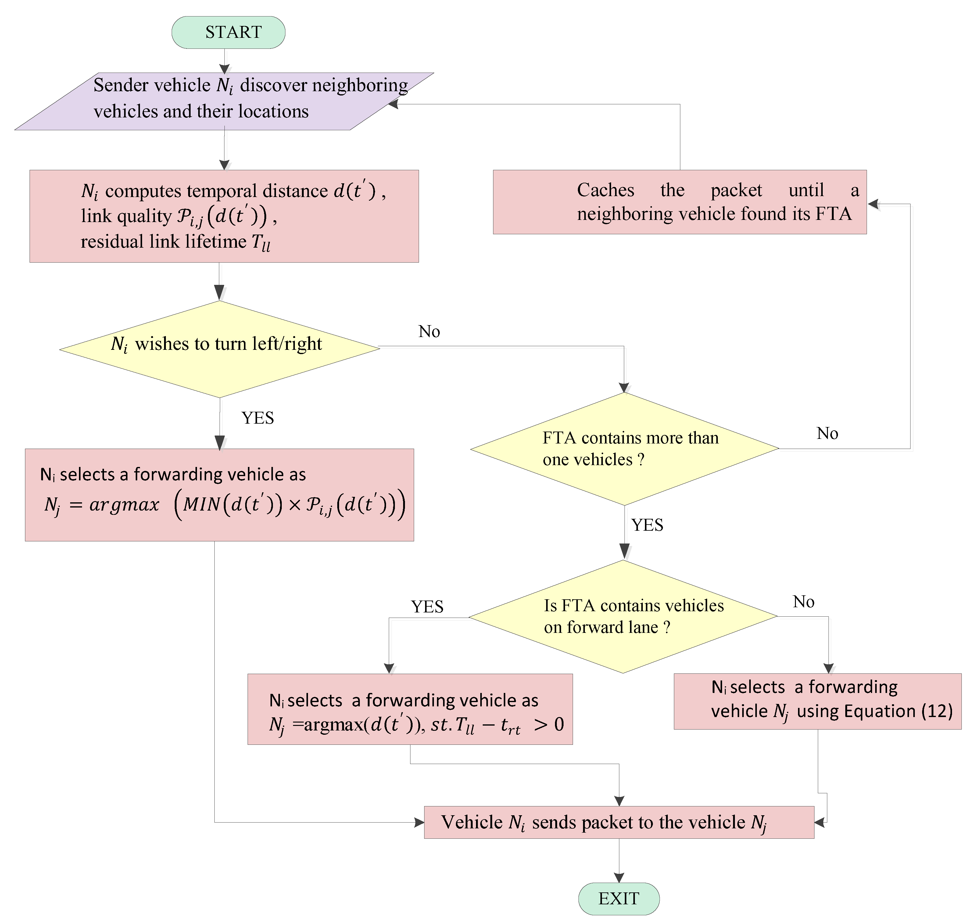
3.5. The Route Construction Algorithm

The proposed EGR routing algorithm is a temporal location-based geocast routing technique in which each sending vehicle N i discovers the temporal locations of its neighboring vehicles utilizing the mathematical formulation given in Equation (1). This is also shown in step 1 of the proposed Algorithm 1
  • Neighbor Discovery: Every vehicle N i sends HELLO packets in its FTA including its coordinates. When a vehicle receives a HELLO packet, it responds with an “ECHO” packet containing positional data. Every vehicle creates a list of its neighbors after receiving these ECHO packets. Only those vehicles that are included in the relevant FTA will be included in the list.
  • Residual Link Lifetime Calculation: The sender N i estimates the residual link lifetime and temporal transmission probability that will be used to find the best forwarding vehicle N j among the discovered neighboring vehicles, as shown in step 2.
  • Route Computation: In step 3, the EGR searches for forwarding vehicle N j using residual link lifetime and temporal transmission probability.
Algorithm 1. EGR Algorithm
Input:  ( x i , y i ) , ( x j , y j ) , v i , v j , θ i and θ j
Output: forwarding vehicle N j
1. 
Neighbor discovery:
Each   vehicle   N i N broadcasts HELLO packet to learn about its each neighboring vehicle N j
vehicle   N i computes its temporal location ( x i , y i )   and   N j computes its temporal location ( x j , y j ) using Equation (1) at time t
2. 
Residual link lifetime calculation:
for each vehicle N j  do
   N i computes temporal distance d ( t ) using Equation (2)
   N i computes link   quality   P i , j ( d ( t ) ) using Equation (8)
   N i estimate residual link   lifetime   T l l using Equation (9)
end for
3. 
Route construction:
if at least one neighbor exists in N i ’s forward region of forward lane and no deviation then
                N j = argmax ( d ( t ) ) ,   s t .   T l l t r t > 0
               Vehicle N i sends packet to the vehicle   N j
else if at least one neighbor exists   in   N i ’s forward region of opposite lane and no deviation then
               choose N j using Equation (12)
               Vehicle N i sends packet to the vehicle N j
else if no vehicles present in forward lane and opposite lane and no deviation then
          Vehicle N i caches the packet until a neighboring vehicle found its forward region
     else if ( N i wishes to deviate)
            N j = a r g m a x     ( M I N ( d ( t ) ) × P i , j ( d ( t ) ) )  
               Vehicle N i sends packet to the vehicle   N j
   end if
A flowchart (see Figure 7) of the proposed EGR for a highway traffic environment when shadowing fading is present is provided for better understanding the logic of it. The flowchart shows the main steps of EGR under fading channel conditions.

4. Simulation and Performance Analysis

The results of the simulations performed assess how well the EGR technique performed in managing sparse vehicular networks in a highway traffic scenario for the high mobility of vehicles. Throughput, end-to-end delay, and one-hop link disconnections were evaluated in the simulation. The EGR algorithm’s results are compared with the following contemporary routing approaches: SLD-GEDIR), J-GEDIR, and P-GEDIR [22].

4.1. Simulation Environment

The NS-2.34 network simulator has been used to simulate the EGR algorithm. An accurate mobility model and a highway traffic environment are produced using the “mobility model generator for vehicular networks” (MOVE) [30]. An open source, highly portable, microscopic, and continuous traffic modeling tool called simulation of urban mobility (SUMO) serves as the foundation for MOVE [31]. The majority of the key elements of the vehicular traffic environment, including the number of roads, the number of lanes, the quantity of intersections, the number of traffic lights in each intersection, the speed of vehicles, the probability that a vehicle will turn left or right at a specific intersection, etc., are set up and implemented using a road map editor and a vehicle movement editor. NS-2 has directly utilized the mobility trace produced by MOVE with SUMO’s support. To evaluate EGR, two types of vehicle traffic environments—high-speed and sparsely connected vehicles—are taken into account. The three EGR modules, namely geometrical localization for GPS outage, link quality, and residual link lifetime, have been implemented [32,33,34]. This investigation focuses on determining if the three EGR modules reduce routing overheads, one-hop link disconnection, and increased throughput with increased vehicle velocity and vehicle density in a highway traffic environment. The simulation region consists of a set of two horizontal and two vertical highways that intersect, creating sixteen junction locations spaced equally apart. Every road has two lanes. Simulation parameters used for the experiment are shown in Table 1. After configuring the network and traffic flow with the parameter values that were taken into consideration, the simulations were run. Locations sending vehicles, destination vehicle, and geocasting region are arbitrarily chosen for each simulation run from one of two predetermined locations that are the same for all ten simulation runs. Each value used in the results analysis was obtained from an average of ten independent simulation runs.

4.2. Simulation Metrics

The performance of EGR and the related exiting routing approaches are compared using the following routing metrics.
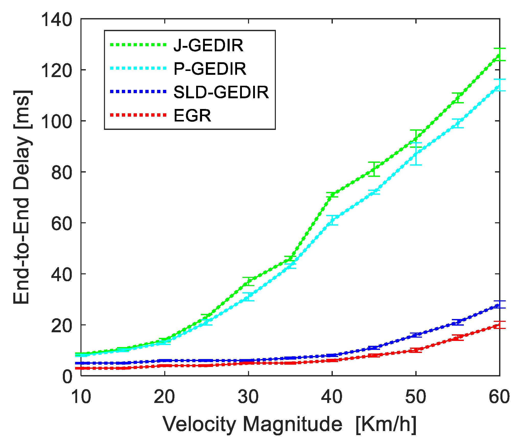
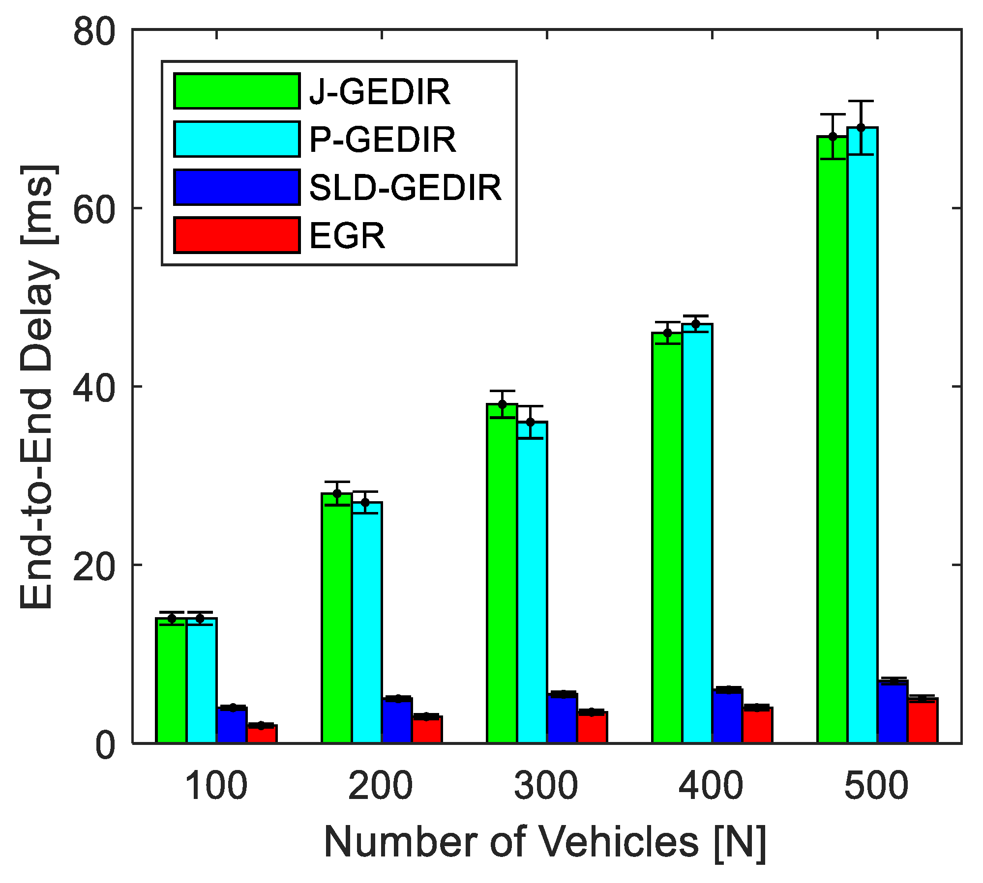
  • End-to-End delay: End-to-end delay is the amount of time for moving a packet from the source to the destination across a network. It is the sum of the delays experienced during transmission, propagation, and processing via each link from the source to the destination. Equation (14) represents the statistical formula that can be used to determine end-to-end delay ( t e e ) in terms of milliseconds and is given by
t e e ( ms )   = i = 1 10 j = 1 n P R ( t S T i , j t R T i , j ) n P R × 10
where n P R represents the number of packets delivered at the destination, t S T i , j denotes the simulation time in the i t h round during which the j t h packet is sent, and t R T i , j denotes the simulation time in the i t h round during which the j t h packet is delivered at the destination.
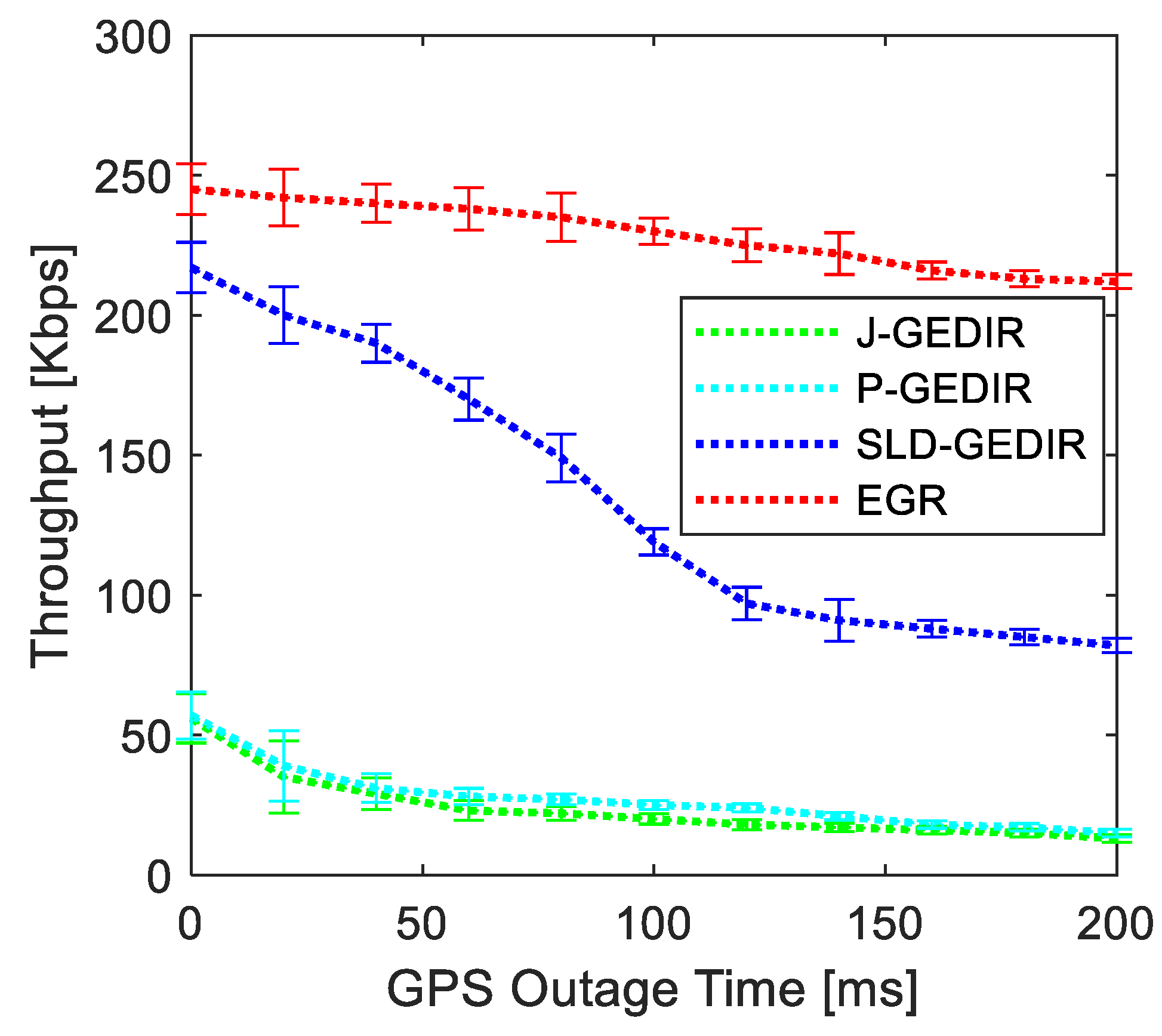
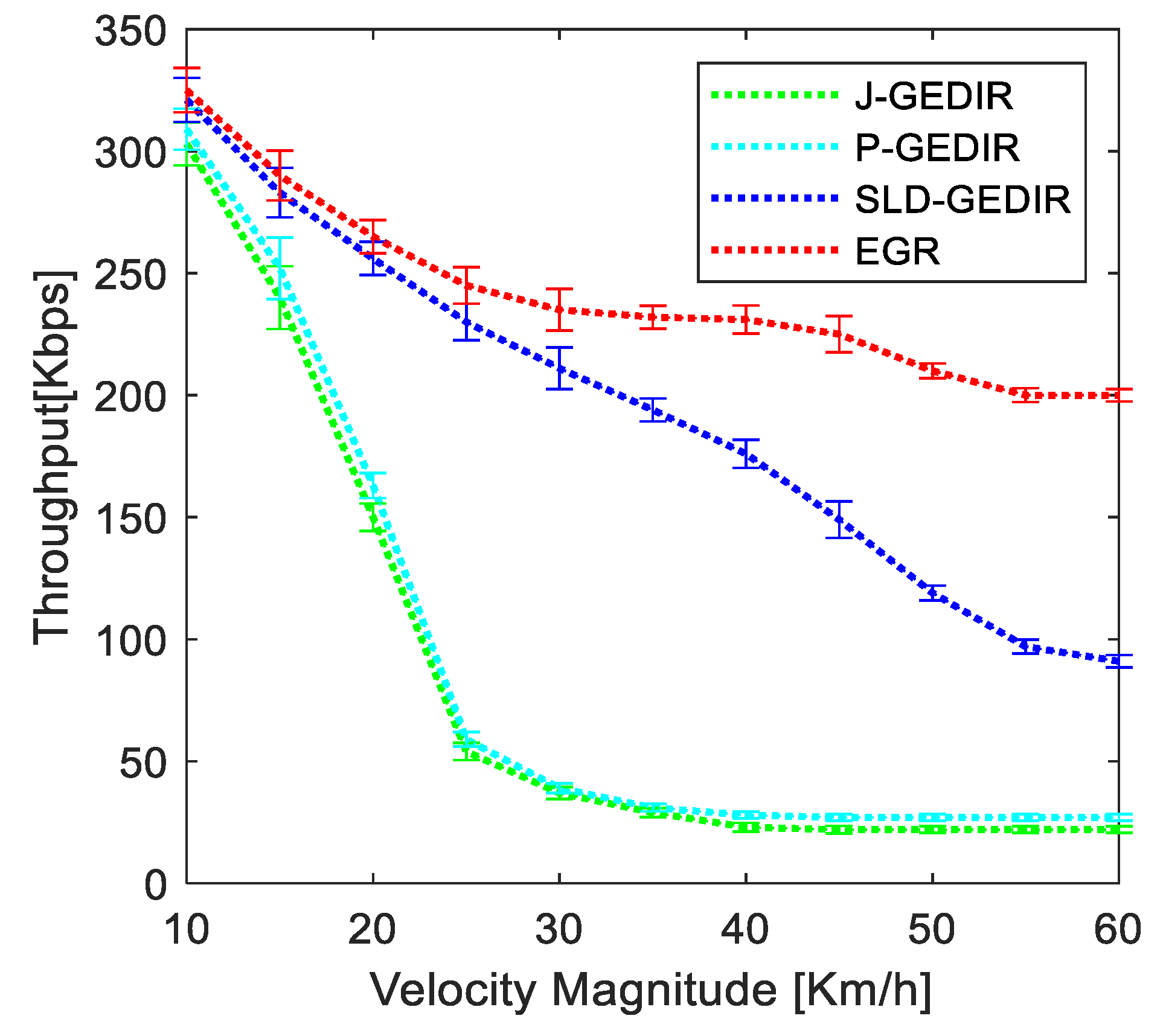
  • Throughput: The throughput is the quantity of packets effectively sent to the destination in a unit simulation time. Bits per second are used to measure it. The limited number of forwarding possibilities available on the highway is due to the fact that there are alternative forms of transportation accessible, and intercity traffic is not extremely heavy. Equation (15), a statistical expression representing throughput ( τ ), is given by
τ   ( kbps ) = i = 1 10 ( n P R × n b ) 10
where n b represents the number of bits per packets.
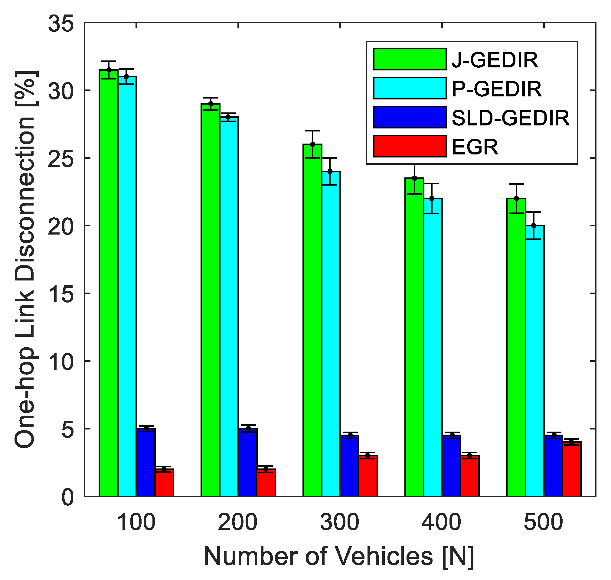
  • One-hop Link Disconnection: One-hop link disconnection is the number of unsuccessful attempts at packet transmission. The reliability of a link is demonstrated by this measure. It affirms the effectiveness of the forwarding vehicle selection process. Equation (16) represents the arithmetical formula that used to quantify one-hop link disconnection ( l d ).
l d ( % ) = { ( i = 1 10 n R D n P S ) 10 } × 100
where n R D denotes the number of unsuccessful attempts to deliver a message from a sending vehicle to destination vehicles in the i t h simulation run and n P S denotes the number of packets delivered to the destination in the i t h simulation run.
As presented in the four cases in Section 3.4, a single best forwarder recipient vehicle is selected considering the current traffic scenario, which might fall into any of the four case studies. We do agree that duplicate messages have been received by some recipient vehicles due to communication reestablishment. However, the duplicate messages are easily discardable considering the packet information, such as sequence number, hop count, and time-to-live timestamp.

4.3. Performance Analysis

The simulation results for analyzing the impact of GPS outage on EGR, effect of vehicle speed on the functionality of EGR, and the investigation of how vehicle density affects performance is presented in this section.
(a) 
Performance Analysis Under GPS Outage
In this section, we determine whether or not EGR is a viable and effective approach for information dissemination under GPS outage problems and how geometrical localization assists EGR to improve the its performance in terms of throughput, end-to-end delay, and one-hop link disconnection. For this simulation, the velocity of the vehicles are 30 km/h. GPS outage time is the length of time in which vehicles lost GPS signal.
Figure 8 shows the end-to-end delay of EGR versus the state-of-the-art geocast routing approaches. It is clear from the result that, as GPS outage time increases, the end-to-end delay for all the geocast routing approaches increases. The end-to-end delay for the EGR is stable and does not increase much with the increase in GPS outage time. However, it is increasing rapidly for J-GEDIR, P-GEDIR, and SLD-GEDIR. For example, GPS outage time is 50 ms; the end-to-end delay for EGR is 15 ms, and for J-GEDIR, P-GEDIR, and SLD-GEDIR, the delays are 50 ms, 65 ms, and 71 ms respectively. This is due to the fact that, with P-GEDIR boundary vehicles as forwarder, J-GEDIR chooses the vehicles from the furthest junctions. The boundary and farthest crossing vehicles are sometimes sensitive to link failure because of the frequent occurrence of GPS outage. All three, J-GEDIR, P-GEDIR, and SLD-GEDIR, do not employ any localization technique for GPS outage problems, whereas the EGR uses geometrical localization for the same problem. The proposed EGR gives an average of 70% lower end-to-end delay as compare to SLD-GEDIR, wherein the end-to-end delay for EGR is about 75% to 80% lower than that of J-GEDIR and P-GEDIR, respectively. Thus, when compared to state-of-the-art routing approaches, the proposed EGR performs better.
Figure 9 shows the throughput of EGR versus state-of-the-art geocast routing approaches. It is clear from the result that, as GPS outage time increases, the throughput for all the geocast routing approaches decreases. For the EGR, it is stable and is not decreasing much with the increase in GPS outage time. However, it is decreasing rapidly for J-GEDIR, P-GEDIR, and SLD-GEDIR. For example, GPS outage time is 50 ms; the throughput for EGR is 240 Kbps, and, for J-GEDIR, P-GEDIR, and SLD-GEDIR, the throughput is 170 Kbps, 30 Kbps, and 31 Kbps, respectively. When GPS outage time is 150 ms, the throughput for EGR is 230 Kbps, and for J-GEDIR, P-GEDIR, and SLD-GEDIR, the throughput is 100 Kbps, 20 Kbps, and 17 Kbps, respectively. This is due to the fact that link failure occurs more frequently due to occurrence of GPS outage for all three, J-GEDIR, P-GEDIR, and SLD-GEDIR, and they do not employ any localization technique for the GPS outage problem, whereas the EGR uses geometrical localization to cope with the same problem. The proposed EGR gives an average of 72% better throughput compared to SLD-GEDIR, wherein the throughput for EGR is about 80% to 90% greater than that of J-GEDIR and P-GEDIR, respectively. The proposed EGR performs better compared to state-of-the-art routing approaches.
Figure 10 compares the results of one-hop link disconnection between EGR and contemporary routing approaches for different values of GPS outage time. It is evident that one-hop link disconnection for EGR is minimal and stable compared to other contemporary routing approaches for GPS outage times of 0 ms and 100 ms. It is because the forwarding vehicle selection process is completed within the residual link lifetime time However, as GPS outage increases to more than 100 ms, the one-hop link disconnections abruptly increase, since the forwarding vehicle selection process could not be finished in the residual link lifetime time in both EGR and SLD-GEDIR. In comparison to J-GEDIR, P-GEDIR, and SLD-GEDIR, the EGR performs better. It is due to the fact that the EGR uses the geometrical localization technique to cope with the GPS outage problem. For the proposed EGR, the average rate of one-hop link disconnection is about 15%, whereas it is about 40% for SLD-GEDIR, and it ranges from 60% to 80% for the rest of the J-GEDIR and P-GEDIR contemporary routing approaches. Thus, EGR performs better than the compared contemporary routing approaches.
(b) 
Performance Analysis Under Vehicle Mobility
The considered matrices have all been evaluated in the simulation for various vehicle velocity magnitudes. Vehicle velocity has been adjusted from 10 to 60 km/h in order to evaluate the performance of EGR. In this simulation, geometrical localization for GSP outage is used with EGR.
According to the result shown in Figure 11, the end-to-end delay for the EGR approach is approximately 4 ms for vehicle velocity between 10 and 40 km/h. Additionally, EGR considerably reduces end to end delay compared with the other routing approaches considered in this simulation. At a velocity greater than 40 km/h, the delay for both EGR and SLD-GEDIR is increasing with a higher rate, but the rate of increment is higher for SLD-GEDIR. This can be due to the forwarding vehicle selection procedure in EGR being done based on the most reliable link and also being made clear in favor of the most likely direction of the destination. At a velocity greater than 20 km/h, J-GEDIR and P-GEDIR performance begins to deteriorate. This is due to the fact that P-GEDIR chooses boundary vehicles as the forwarder, and J-GEDIR chooses the vehicles from the furthest junctions. The boundary and farthest crossing vehicles are sometimes sensitive to link failure because of the frequent movement of the traffic environment. The proposed EGR gives an average of 25% lower end-to-end delay compared to SLD-GEDIR, wherein the end-to-end delay for EGR is about 60% to 70% lower than that of J-GEDIR and P-GEDIR, respectively. Thus, when compared to state-of-the-art routing approaches, the proposed EGR performs better.
In Figure 12, the findings demonstrate a throughput comparison between EGR and other procedures, taking into account variable velocity. The findings show that, when vehicle velocity increases, the throughput of EGR linearly decreases. The throughput for the existing routing approaches, however, dramatically drops. For example, the throughput values of J-GEDIR, P-GEDIR, SLD-GEDIR, and EGR at a vehicle velocity of 20 Km/h are 150 Kbps, 163 Kbps, 256 Kbps, and 265 Kbps, respectively; when the velocity increases to 40 Km/h, the throughput values decreased to 23 Kbps, 28 Kbps, 176 Kbps, and 231 Kbps respectively. This can be linked to the fact that, due to the high rate of link breakage with increased vehicle speed, modern protocols must frequently re-discover one-hop links. The link chosen by EGR is based on a temporal transmission probability and a residual link lifetime that increases its reliability. As a result, EGR consistently performs better than the existing routing approaches considered in this simulation.
Figure 13 compares the results of one-hop link disconnection between EGR and contemporary routing approaches. It is evident that one-hop link disconnection for EGR is minimal compared to other contemporary routing approaches for velocities between 10 and 60 km/h. It is because the most reliable link for the transmission of information between the sender vehicle and the farthest forwarding vehicle is picked. However, at speeds over 40 km/h, one-hop link disconnections abruptly increase, since the forwarding vehicle selection process could not be finished in the residual link lifetime time in both EGR and SLD-GEDIR. In comparison to J-GEDIR and P-GEDIR, both EGR and SLD-GEDIR perform the best in relation to the quantity of one-hop link disconnections. However, it is lower for EGR compared with SLD-GEDIR. Because the forwarding technique employed in J-GEDIR and P-GEDIR does not take velocity information into account in NHV selection, one-hop link disconnections in P-GEDIR and J-GEDIR are experienced rapidly above a velocity of 20 Km/h. Due to its higher number of hops between the source and destination regions, for the proposed EGR, the average rate of one-hop link disconnection is about 5%, whereas it is about 8% for SLD-GEDIR, and it ranges from 40% to 50% for the rest of the J-GEDIR and P-GEDIR contemporary routing approaches. Thus, EGR performs better than the compared contemporary routing approaches.
(c) 
Performance Analysis Under Vehicle Density
Herein, we examine the effect of vehicle density on the effectiveness of the proposed approach. In this simulation, geometrical localization for GSP outage is used with EGR.
According to the result shown in Figure 14, the EGR has the minimum end-to-end delay when compared to other contemporary routing approaches. Due to its distinctive forwarding vehicle selection procedure, the end-to-end delay of the both EGR and SLD-GEDIR is not affected much by increasing vehicle density. However, EGR takes less time for the transmission of the packets from a source vehicle to the destination vehicle because it uses residual link lifetime, which reduces the number of unnecessary attempts of sending a packet between two vehicles that ultimately reduces the transmission delay. Contemporary routing approaches J-GEDIR and P-GEDIR pick many forwarding vehicles, which results in longer end-to-end delays. It is also significant that contemporary routing approaches reduce the area in which possible forwarding vehicles belong, and they choose these forwarding vehicles, which results in approximately equal end-to-end latency. The proposed EGR gives an average 35% lower end-to-end delay compared to SLD-GEDIR, wherein the end-to-end delay for EGR is about 70% to 75% lower than that of J-GEDIR and P-GEDIR, respectively. Thus, it is evident that EGR performs contemporary routing approaches.
The results shown in Figure 15 reveal that, with 100 vehicles in the forward transmission region, the throughput of EGR is almost the same as in the contemporary routing approaches. However, as the number of vehicle increases, the throughput of the contemporary routing approaches J-GEDIR and P-GEDIR declines more quickly than in both EGR and SLD-GEDIR. The rate of decrement in SLD-GEDIR is more compared to EGR. This is due the fact that EGR picks forwarding vehicle with the highest reliable link between itsself and the sender, reducing the amount of packet loss during transmission. The proposed EGR gives an average 10% higher throughput compared to SLD-GEDIR, wherein, for EGR, it is about 25% to 30% higher than that of J-GEDIR and P-GEDIR, respectively. Hence, EGR outperforms contemporary routing approaches in terms of throughput.
The simulation results for one-hop link disconnection with increasing vehicles density are shown in Figure 16. It is evident that EGR has fewer one-hop link disconnections than the routing approaches that are considered to be contemporary routing approaches. It is also interesting to note that, in contrast to contemporary routing approaches, the link disconnections of both EGR and SLD-GEDIR do not change much with increasing vehicle density but rather slightly decrease. This is because both routing approaches only ever chooses one forwarding vehicle, but in other two contemporary routing approaches, J-GEDIR and P-GEDIR, the number of forwarding vehicles rises as vehicle density rises. For the proposed EGR, the average rate of one-hop link disconnection is about 3%, whereas it is about 5% for SLD-GEDIR, and it ranges from 20% to 30% for the rest of the J-GEDIR and P-GEDIR contemporary routing approaches. As a result, it can be seen that the proposed EGR exhibits less link disconnection than most contemporary routing approaches.

5. Conclusions and Future Work

In this paper, an efficient geocast routing (EGR) approach using the temporal dependence of link quality for a highway traffic environment is presented. A geometrical localization for GPS outage problem and a temporal link quality estimation model are presented to support the EGR. We develop a framework for analysis that quantifies the likelihood of choosing the longest-lasting link out of a list of predetermined links between a transmitting vehicle and its surrounding vehicles. The EGR performs better under the shadowing fading channel situation while choosing a next forwarding vehicle using the probability measure. The performance of EGR in highway traffic environments is measured for both increasing vehicle density and increasing vehicle velocity. A comparative performance study based on simulations has been done to assess the efficacy and scalability of EGR in terms of resolving the issue of wireless communication link breakage and assuring message delivery in a highway traffic environment. It is evident from the examination of simulation results that EGR is superior than contemporary routing approaches for different vehicle traffic settings. In the future, we measure the performance of the proposed EGR in the presence of interfering vehicles for a highway traffic environment.

Author Contributions

Conceptualization R.Y.; formal analysis S.K.; investigation, R.Y.; methodology, R.Y.; supervision, S.K. and O.K.; validation, A.K. and D.; writing, R.Y.; review and editing, S.K., O.K., M.A. and J.L. All authors have read and agreed to the published version of the manuscript.

Funding

The research is funded by the School of Computer and Systems Science, Jawaharlal Nehru University, India.

Data Availability Statement

Research data will be available on individual requests to the corresponding author considering collaboration possibilities with the researcher or research team and with restrictions that the data will be used only for further research in the related literature progress.

Acknowledgments

The research is supported by the Computing and Informatics Research Center, Department of Computer Science, Nottingham Trent University, UK.

Conflicts of Interest

The authors declare that they have no conflict of interest.

References

  1. Kaiwartya, O.; Abdullah, A.H.; Cao, Y.; Altameem, A.; Prasad, M.; Lin, C.-T.; Liu, X. Internet of Vehicles: Motivation, Layered Architecture, Network Model, Challenges, and Future Aspects. IEEE Access 2016, 4, 5356–5373. [Google Scholar] [CrossRef]
  2. Li, Y.; Barthelemy, J.; Sun, S.; Perez, P.; Moran, B. Urban Vehicle Localization in Public LoRaWan Network. IEEE Internet Things J. 2021, 9, 10283–10294. [Google Scholar] [CrossRef]
  3. Kaiwartya, O.; Kumar, S. Guaranteed Geocast Routing Protocol for Vehicular Adhoc Networks in Highway Traffic Environment. Wirel. Pers. Commun. 2015, 83, 2657–2682. [Google Scholar] [CrossRef]
  4. Kumar, S.; Dohare, U.; Kumar, K.; Dora, D.P.; Qureshi, K.N.; Kharel, R. Cybersecurity Measures for Geocasting in Vehicular Cyber Physical System Environments. IEEE Internet Things J. 2018, 6, 5916–5926. [Google Scholar] [CrossRef]
  5. Kaiwartya, O.; Cao, Y.; Lloret, J.; Kumar, S.; Aslam, N.; Kharel, R.; Abdullah, A.H.; Shah, R.R. Geometry-Based Localization for GPS Outage in Vehicular Cyber Physical Systems. IEEE Trans. Veh. Technol. 2018, 67, 3800–3812. [Google Scholar] [CrossRef] [Green Version]
  6. Blum, J.; Eskandarian, A.; Hoffman, L. Challenges of Intervehicle Ad Hoc Networks. IEEE Trans. Intell. Transp. Syst. 2004, 5, 347–351. [Google Scholar] [CrossRef]
  7. Sofra, N.; Gkelias, A.; Leung, K.K. Route Construction for Long Lifetime in VANETs. IEEE Trans. Veh. Technol. 2011, 60, 3450–3461. [Google Scholar] [CrossRef] [Green Version]
  8. U.S. Department of Transportation. ITS Strategic Plan 2015–2019. Available online: http://www.its.dot.gov/research_areas/strategicplan2015.htm (accessed on 10 October 2022).
  9. Fawcett, J.; Robinson, P. Adaptive routing for road traffic. IEEE Comput. Graph. Appl. 2000, 20, 46–53. [Google Scholar] [CrossRef] [Green Version]
  10. Ammoun, S.; Nashashibi, F.; Laurgeau, C. Crossroads risk assessment using GPS and inter-vehicle communications. IET Intell. Transp. Syst. 2007, 1, 95–101. [Google Scholar] [CrossRef]
  11. Wu, D.; Zhang, Y.; Bao, L.; Regan, A.C. Location-Based Crowdsourcing for Vehicular Communication in Hybrid Networks. IEEE Trans. Intell. Transp. Syst. 2013, 14, 837–846. [Google Scholar] [CrossRef]
  12. Cui, Y.; Ge, S.S. Autonomous vehicle positioning with GPS in urban canyon environments. IEEE Trans. Robot. Autom. 2003, 19, 15–25. [Google Scholar]
  13. Kaiwartya, O.; Kumar, S. Geocasting in vehicular adhoc networks using particle swarm optimization. In Proceedings of the International Conference on Information Systems and Design of Communication Lisbon, Lisboa, Portugal, 16–17 May 2014; pp. 62–66. [Google Scholar]
  14. Tsiachris, S.; Koltsidas, G.; Pavlidou, F.-N. Junction-Based Geographic Routing Algorithm for Vehicular Ad hoc Networks. Wirel. Pers. Commun. 2012, 71, 955–973. [Google Scholar] [CrossRef]
  15. Raw, R.S.; Das, S. Performance analysis of P-GEDIR protocol for vehicular adhoc network in urban traffic environments. Wirel. Pers. Commun. 2013, 68, 65–78. [Google Scholar] [CrossRef]
  16. Stojmenovic, I.; Ruhil, A.P.; Lobiyal, D.K. Voronoi diagram and convex hull based geocasting and routing in wireless networks. Wirel. Commun. Mob. Comput. 2006, 6, 247–258. [Google Scholar] [CrossRef]
  17. Kaiwartya, O.; Kumar, S.; Lobiyal, D.K.; Abdullah, A.H.; Hassan, A.N. Performance Improvement in Geographic Routing for Vehicular Ad Hoc Networks. Sensors 2014, 14, 22342–22371. [Google Scholar] [CrossRef] [PubMed] [Green Version]
  18. Sangho, O.; Jaewon, K.; Gruteser, M. Location-based flooding techniques for Vehicular emergency messaging (D-Flooding). In Proceedings of the 2006 Third Annual International Conference on Mobile and Ubiquitous Systems: Networking & Services, San Jose, CA, USA, 17–21 July 2006; Springer: Berlin/Heidelberg, Germany, 2006; pp. 1–9. [Google Scholar]
  19. Maihofer, C.; Eberhardt, R. Geocast in vehicular environments: Caching and transmission range control for improved efficiency (CTRC). In Proceedings of the 2004 Intelligent Vehicles Symposium, Parma, Italy, 14–17 June 2004; IEEE: Piscataway, NJ, USA, 2004; pp. 951–956. [Google Scholar]
  20. Raw, R.S.; Lobiyal, D.K. B-MFR routing protocol for vehicular ad hoc networks. In Proceedings of the 2010 International Conference on Networking and Information Technology (ICNIT), Manila, Philippines, 11–12 June 2010; pp. 420–423. [Google Scholar]
  21. Sommer, C.; Tonguz, O.K.; Dressler, F. Traffic information systems: Efficient message dissemination via adaptive beaconing. IEEE Commun. Mag. 2011, 49, 173–179. [Google Scholar] [CrossRef] [Green Version]
  22. Qing, Y.; Lim, A.; Shuang, L.; Jian, F.; Agrawal, P. ACAR: Adaptive Connectivity Aware Routing Protocol for Vehicular Ad Hoc Networks. In Proceedings of the 17th International Conference on Computer Communications and Networks, ICCCN’08, Saint Thomas, VI, USA, 3–7 August 2008; pp. 1–6. [Google Scholar]
  23. Kaiwartya, O.; Kumar, S. Cache agent-based geocasting in VANETs. Int. J. Inf. Commun. Technol. 2015, 7, 562. [Google Scholar] [CrossRef]
  24. Kasana, R.; Kumar, S. Multimetric Next Hop Vehicle Selection for Geocasting in Vehicular Ad-hoc Networks. In Proceedings of the 2015 IEEE International Conference on Computational Intelligence & Communication Technology, Ghaziabad, India, 13–14 February 2015; pp. 400–405. [Google Scholar]
  25. Li, Z.; Wu, P. Intermittent geocast routing in urban vehicular delay tolerant networks. Tsinghua Sci. Technol. 2016, 21, 630–642. [Google Scholar] [CrossRef]
  26. Karimi, R.; Shokrollahi, S. PGRP: Predictive geographic routing protocol for VANETs. Comput. Netw. 2018, 141, 67–81. [Google Scholar] [CrossRef]
  27. Kasana, R.; Kumar, S.; Kaiwartya, O.; Yan, W.; Cao, Y.; Abdullah, A.H. Location error resilient geographical routing for vehicular ad-hoc networks. IET Intell. Transp. Syst. 2017, 11, 450–458. [Google Scholar] [CrossRef] [Green Version]
  28. Oliveira, H.A.; Nakamura, E.F.; Loureiro, A.A.; Boukerche, A. Error analysis of localization systems for sensor networks. In Proceedings of the 13th Annual ACM International Workshop on Geographic Information Systems, New York, NY, USA, 4–5 November 2005; ACM: New York, NY, USA, 2005; pp. 71–78. [Google Scholar]
  29. Qureshi, K.N.; Islam, F.U.; Kaiwartya, O.; Kumar, A.; Lloret, J. Improved Road Segment-Based Geographical Routing Protocol for Vehicular Ad-hoc Networks. Electronics 2020, 9, 1248. [Google Scholar] [CrossRef]
  30. Bai, X.; Chen, S.; Shi, Y.; Liang, C.; Lv, X. Blockchain-based Authentication and Proof-of-Reputation Mechanism for Trust Data Sharing in Internet of Vehicles. Adhoc Sens. Wirel. Netw. 2022, 53, 85–113. [Google Scholar]
  31. Pandey, P.K.; Kansal, V.; Swaroop, A. ALMR: Alternate Link Based Multipath Reactive Routing Protocol for Vehicular Ad Hoc Networks (VANETs). Adhoc Sens. Wirel. Netw. 2021, 50, 27–53. [Google Scholar]
  32. Rathore, R.; Sangwan, S.; Kaiwartya, O. Towards Trusted Green Computing for Wireless Sensor Networks: Multi Metric Optimization Approach. Ad Hoc Sens. Wirel. Netw. 2021, 49, 131–171. [Google Scholar]
  33. Hizal, S.; Zengin, A. QEAODV: A New Routing Protocol based on Quality of Service in MANETs. Adhoc Sens. Wirel. Netw. 2021, 49, 81–109. [Google Scholar]
  34. Prasad, M.; Liu, Y.-T.; Li, D.-L.; Lin, C.-T.; Shah, R.R.; Kaiwartya, O.P. A New Mechanism for Data Visualization with Tsk-Type Preprocessed Collaborative Fuzzy Rule Based System. J. Artif. Intell. Soft Comput. Res. 2017, 7, 33–46. [Google Scholar] [CrossRef]
Figure 1. A highways traffic Environment.
Electronics 12 00130 g001
Figure 2. A vehicle’s localization scenario.
Electronics 12 00130 g002
Figure 3. Selection of a vehicle for transmission.
Electronics 12 00130 g003
Figure 4. Selection of a vehicle in opposite lane.
Electronics 12 00130 g004
Figure 5. Re-caching by sending vehicle.
Electronics 12 00130 g005
Figure 6. A sending vehicle deviation.
Electronics 12 00130 g006
Figure 7. Flowchart of EGR.
Electronics 12 00130 g007
Figure 8. Effect of GPS outage on end-to-end delay.
Electronics 12 00130 g008
Figure 9. Effect of GPS outage on throughput.
Electronics 12 00130 g009
Figure 10. Effect of GPS outage on one-hop link disconnection.
Electronics 12 00130 g010
Figure 11. Effect of velocity on end-to-end delay.
Electronics 12 00130 g011
Figure 12. Effect of velocity on throughput.
Electronics 12 00130 g012
Figure 13. Effect of Velocity on one-hop link disconnection.
Electronics 12 00130 g013
Figure 14. Effect of vehicle density on end-to-end delay.
Electronics 12 00130 g014
Figure 15. Effect of vehicle density on throughput.
Electronics 12 00130 g015
Figure 16. Effect of vehicle density on one-hop link disconnection.
Electronics 12 00130 g016
Table 1. Simulation Parameters.
ParametersValuesParametersValues
Total time 500   s Ifqlen 50 packets
Simulation area 2000 × 2000   m 2 Channel typeWireless
Vehicle speed 10 60   Km / h Antenna modelOmni directional
Number of vehicles 500 vehiclesPropagation modelShadowing
Source vehicles 20 MAC data rate 5   Mbps
Tranmission range300 mMAC protocolIEEE 802.11p
Junction8CBR rate 6   Packets / s
Hello timeout 0.5   s Packet typeUDP
Query period 2.5   s Packet size512 bytes
Traffic typeCBRGeocast region size 500 × 500   m 2
Disclaimer/Publisher’s Note: The statements, opinions and data contained in all publications are solely those of the individual author(s) and contributor(s) and not of MDPI and/or the editor(s). MDPI and/or the editor(s) disclaim responsibility for any injury to people or property resulting from any ideas, methods, instructions or products referred to in the content.

