Article

A CEI-Based Method for Precise Tracking and Measurement of LEO Satellites in Future Mega-Constellation Missions

1
Department of Electrical and Optical Engineering, Space Engineering University, Beijing 101400, China
2
Key Laboratory of Intelligent Space TTC and Operation, Space Engineering University, Ministry of Education, Beijing 101400, China
*
Author to whom correspondence should be addressed.
These authors contributed equally to this work.
Electronics 2023, 12(16), 3385; https://doi.org/10.3390/electronics12163385
Submission received: 1 July 2023 / Revised: 30 July 2023 / Accepted: 7 August 2023 / Published: 8 August 2023
(This article belongs to the Section Microwave and Wireless Communications)

Abstract

:
With the development of low-orbit mega-constellations, low-orbit navigation augmentation systems, and other emerging LEO projects, the tracking accuracy requirement for low-orbit satellites is constantly increasing. However, existing methods have obvious shortcomings, and a new tracking and measurement method for LEO satellites is thus urgently needed. Given this, in this paper, a Connected Element Interferometry (CEI)-based “near-field” measurement model for low-orbit satellites is proposed. On this basis, the goniometric error formula of the model is derived, and the factors included in each error source are briefly discussed, followed by the simplification of the error formula. Furthermore, for the feasibility analysis of the proposed method, the common view time of CEI array on LEO satellites is analyzed in different regions and different baseline lengths. Finally, this paper simulates the effects of satellite–station distance, baseline length, and goniometric angle on the error coefficients in the goniometric error formula, and provides the theoretical goniometric accuracy of this model for different baseline lengths and goniometric angles. Under a baseline length of 240 km, the accuracy can reach 10 nrad. The research results of this paper could play the role of theoretical a priori in accuracy prediction in future low-orbit satellite tracking measurements.

1. Introduction

For an extended period, compared with the tracking of MEO/HEO satellites or deep space exploration, the tracking accuracy of LEO satellites is lower [1,2,3]. This is mainly because (1) LEO satellites have lower-orbit altitudes, thus, the orbit determination error caused by goniometric error is smaller than high-orbit targets. (2) the function of the majority of LEO satellites is communication or remote sensing [4,5], thus, the requirements for orbit determination accuracy of most LEO satellites are relatively low. Furthermore, there has been an increase in LEO plans, such as low-orbit mega-constellations [6,7,8], which is booming. The Starlink [9] proposed by SpaceX of the United States currently has more than 4000 satellites in orbit, and it plans to launch 42,000 satellites in the future [10,11,12]. OneWeb plans to build a constellation system consisting of 1600 satellites [10,13,14,15]. Additionally, the total number of GW (Guowang) constellations that China plans to launch reaches 12,992 [16,17]. Meanwhile, Emilio Matricciani proposed a constellation design called geostationary surface (GeoSurf). This constellation has the advantages of most Leo, MEO, and GEO constellations, but avoids the disadvantages [18]. It is expected to play an important role in the construction of giant constellations in the future.
There are also other ambitious LEO projects, such as the low-orbit navigation augmentation system [19,20,21] and the maintenance of satellite formation configuration [22,23], etc. The use of low-orbiting satellites for navigation augmentation has become a hot research topic. For example, the US plans to back up the GPS positioning and timing service capability with the Iridium system [24], and Europe plans to significantly enhance the Galileo system with the Kepler LEO system [25]. These plans offer significant advantages such as reducing the initial positioning convergence time and providing stronger navigation signal reception. This enables positioning capabilities even in challenging conditions like obstruction or indoor environments [26,27]. Nevertheless, the low-orbiting satellite navigation augmentation system calls for higher-orbit accuracy of the LEO satellite in the system. Mingxing Ke et al. proposed that the critical point for LEO satellite orbit error was 0.35 m, beyond which positioning accuracy would deteriorate [28]. While Xiangjun Li et al. applied the Fourier series to fit the orbit error of LEO satellites and found that the orbit error should be less than 12 cm to ensure the convergence time of the combined PPP (Precise Point Positioning) [29]. Furthermore, the development of satellite formation technology also calls for more precise measurement and tracking accuracy for LEO targets, the key factor affecting the efficiency of satellite formation in orbit is the high-precision determination of the relative positions between satellites [30,31].
Conclusively, urgent requirements are waiting for the accurate and reliable tracking of LEO targets, in constellation or single formation. However, the existing low-orbit satellite tracking measurement means all have certain limitations: optical goniometry has a slightly lower accuracy, which is in the arcsecond range, and is easily affected by the weather; thus, it is unable to achieve all-weather measurement [32,33,34]. Comparatively, even though satellite laser ranging has reached millimeter-level radial measurement accuracy, it requires a laser backward reflector array on the satellite surface for distance measurement, which is too costly for a large number of low-orbiting satellites [35,36]. The USB (Unified S Band) system requires an on-board transponder to complete the measurement and control tasks, and its accuracy is lower compared to the phase interferometry system.
Considering this, the requirements for the tracking accuracy of LEO satellites are doomed to increase significantly, and urgent improvements are called for. Therefore, it can be seen that the contradiction between the limited space of low orbit and the increasing number of satellites is becoming more and more serious [37]. At the same time, the contradiction between the continuous improvement of the positioning accuracy requirements of some special missions and the low accuracy of existing tracking and measurement methods is becoming more and more prominent. These two problems pose great challenges to the existing tracking and measurement methods, resulting in a further shortage of measurement and control resources. Given this, it is urgent to explore a new low-earth orbit satellite tracking and measurement technology, which can be combined with the existing means to achieve high-precision orbit determination for low-earth orbit satellites.
The radio interferometry technology represented by the Connected Elements Interferometry (CEI) technology [38] realizes time delay measurement by tracking and measuring the phase difference of carrier or sidetone between two stations 10–200 km apart. It uses the optical fiber between stations to transmit time, frequency, and information, to achieve high-precision synchronization of time and frequency; then, the accurate angular position of the target relative to the baseline vector between two stations can be determined in real-time or quasi-real time [39,40]. CEI has a shorter baseline length than VLBI (Very Long Base Interferometry). The main difference is that CEI improves the observation accuracy through high-precision time and frequency, while VLBI improves the measurement accuracy mainly by increasing the baseline length. The accuracy of the two methods is different in specific application scenarios. the theoretical angle measurement accuracy of CEI can reach 2 nrad–5 nrad.
CEI technology has been widely used in the tracking and orbit determination of Earth satellites and interplanetary detectors from the 1960s to the 1980s [41]. Later, with the development of technology, it has mainly been used in the precise orbit determination of GEO, HEO, or deep space targets [42,43], but is less used in the tracking and measurement of low-orbit satellites. Yuji Sakamoto et al. used a radio interferometer of small-diameter antennas for LEO satellite orbit determination. They confirmed that the satellite position and velocity can be estimated with an accuracy of a few tens of meters and a few tens of mm/s for a baseline length of 75 m and an altitude of the satellite of 1400 km [44]. Liao Chen et al. successfully achieved the full chain and system validation of the CEI system for non-cooperative targets in LEO from tracking and measurement to orbit determination [45].
Compared with radar, optics, USB, laser, and other tracking and measurement methods, CEI technology has the following advantages [46]: (1) Passive measurement technology based on a ranging signal does not need to add spaceborne equipment and does not affect the signal system of the original system; (2) The flexible and fast layout of a small ground tracking network can be realized. (3) It is not affected by weather and can work all day. Therefore, it can be used as a tracking and measurement method for some low-orbit satellites with high-precision orbit determination requirements, and can also be used as the main backup technology for low-orbit satellite tracking and measurement [34].
In summary, to meet the urgent needs of LEO satellite tracking measurement and the shortcomings of existing measurement means, this paper proposes to adopt CEI-based technology to achieve reliable and higher accuracy tracking measurement of LEO satellites. The work carried out in this paper is summarized in the following section.
Firstly, the paper introduces the CEI traditional goniometric model based on “far-field” measurements and analyses the deterioration of the traditional model in the case of low-orbit satellites, and then proposes the CEI goniometric model based on “near-field” measurements. Secondly, this paper deduces the goniometric error formula of the new model and briefly analyses the main factors included in each error source in the error formula. Considering the huge impact of tropospheric water vapor on radio propagation, this paper focuses on the impact of rain in the discussion of phase difference error source [47]. Thirdly, this paper explores the effect of CEI array baseline length and satellite orbit altitude on satellite common view time. To the best of our knowledge, this is the first time CEI has been applied in the precise measurement and tracking of LEO satellites and LEO mega-constellations, especially together with the relevant goniometric model and error formulation. Subsequently, to facilitate the simulation analysis, the goniometric error formula is reasonably simplified by calculation. Finally, this paper simulates the common view time of CEI arrays for LEO satellites with different geographical regions and baseline lengths. The results illustrate the feasibility of using the CEI technique to track and measure LEO satellites in terms of common view time. Additionally, it also simulates the effects of the factors in the goniometric error formula on the error coefficients and gives the theoretical goniometric accuracy under different baseline lengths and goniometric conditions. The simulation analysis shows that, when the baseline length is 240 km and the goniometric angle is 80°, the theoretical goniometric accuracy of the model can reach 10 nrad.
Subsequently, based on the angle measurement model in this paper, further research on the orbit determination system of low-orbit satellites by CEI can be carried out. The research results of this paper could play the role of theoretical a priori and accuracy prediction in future low-orbit satellite tracking measurement, and are expected to be applied in future low-orbit satellite high-precision tracking measurements, which could play a significant role in the increasing severe LEO target monitoring and space situational awareness missions.

2. Thesis Structure and Symbol Description

2.1. Thesis Structure

As depicted in Figure 1, this paper is primarily composed of Section 3, Section 4, Section 5 and Section 6. Section 3 proposes a goniometric model for LEO satellites based on CEI technology. During the establishment of the model, reference is made to the traditional CEI goniometric model, and a detailed derivation process is provided. In Section 4, the goniometric error equation for the proposed model is derived, and a brief analysis is conducted on the impact of each error source on the goniometric accuracy. Section 5 explores the common view time of LEO satellites by the CEI station array and simplifies the goniometric error equation, laying the groundwork for the subsequent simulation analysis. Section 6 presents the simulations of satellite common view time and goniometric errors, and provides the theoretical goniometric accuracy of the model for different baseline lengths and angles.

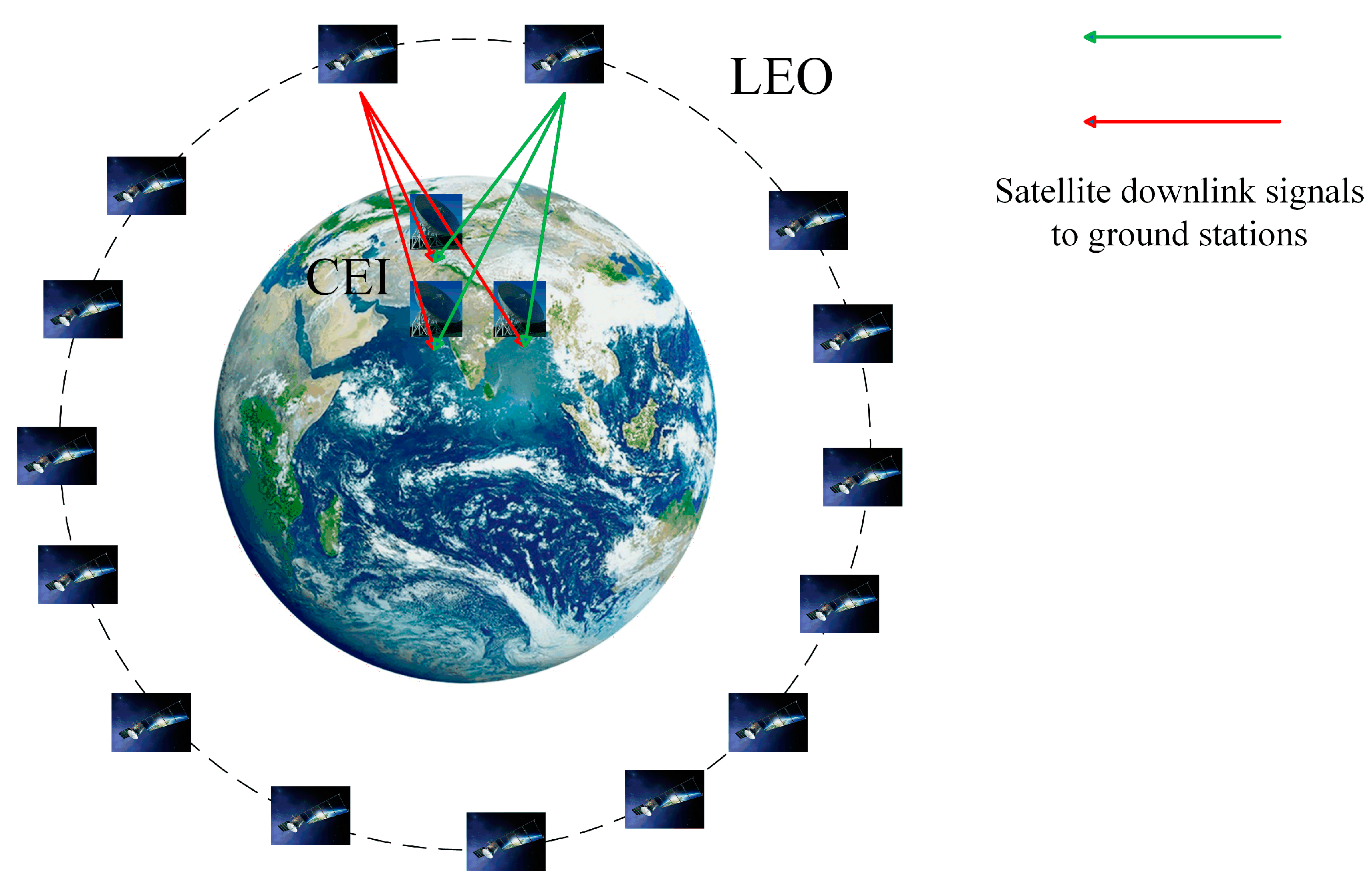
2.2. The Basic Scenario of the Proposed Method

Figure 2 illustrates the main scenario for this paper, which mainly consists of a large number of LEO satellites and CEI array.
The goniometric model proposed in this paper involves three main steps. Firstly, the CEI array on the ground receives the downlink ranging signal transmitted by a LEO satellite and measures the phase difference between the received signals. Secondly, the relative distance between the satellite and the ground station can be determined by analyzing the ranging signal. Finally, utilizing the phase difference, distance between satellite and ground station, frequency of the downlink signal and baseline length, the azimuth and pitch angles of the satellite can be calculated.
The subsequent sections will provide a detailed explanation of the angle measurement principle and the derivation of the corresponding formula.

2.3. Symbol Description

The description of the main symbols in this paper are shown in Table 1.

3. The Goniometric Model of LEO Satellites Based on CEI

Firstly, this section presents the traditional CEI angle measurement model for HEO satellites [48], which is based on “far-field” measurement. Secondly, the traditional model is suitably modified by examining the limitations of it in the LEO satellite scenario. Thirdly, this paper derives the goniometric model of LEO satellites using CEI, which is based on “near-field” measurement. It is important to note that the terms “far-field” and “near-field” used in this paper do not refer to antenna far-field and near-field, but are used to distinguish between the goniometric models of HEO and LEO satellites.

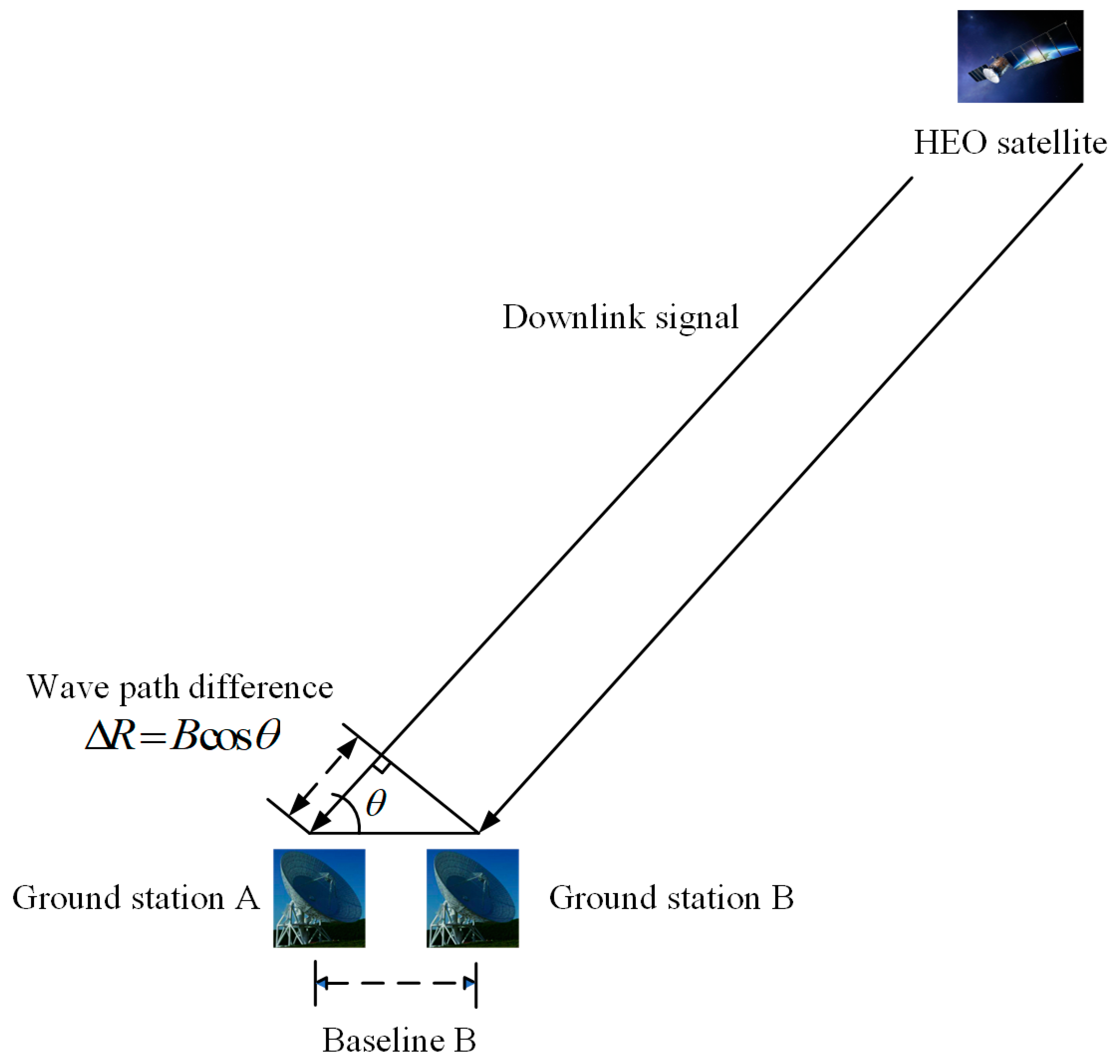
3.1. CEI Goniometric Model for HEO Satellites Based on “Far-Field” Measurements

Figure 3 illustrates the principle of the traditional CEI goniometric model for HEO satellites. Due to the large distance between the satellite and the antenna of ground station, the two downlink signals from ground stations A and B can be regarded as parallel. This means that the electromagnetic waves received by the two antennas can be approximated as plane waves. Consequently, the wave range difference can be wrote as Δ R = B cos θ , which results in a phase difference φ . That is,
φ = ω R F c Δ R = ω R F c B cos θ
where ω R F is the downlink signal frequency, c is the speed of light, Δ R is the wave range difference between the two downlink signals, and B is the baseline length. Then, the angular information θ can be calculated from the phase difference φ according to Equation (1).

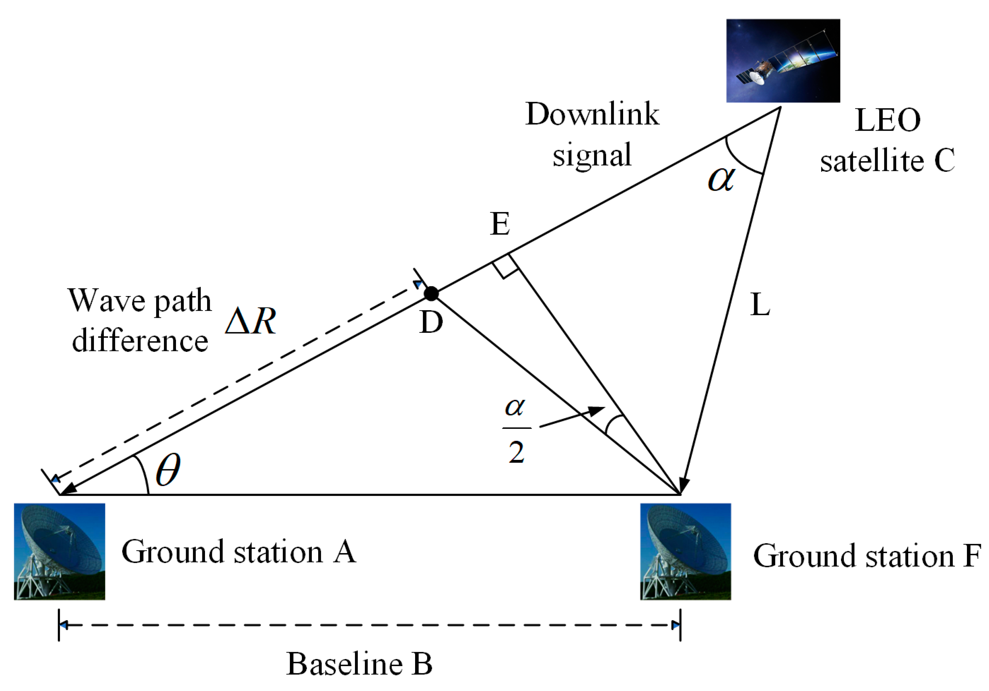
3.2. CEI Goniometric Model for LEO Satellites Based on “Near-Field” Measurements

Figure 4 illustrates the wave range error of the conventional CEI measurement model for HEO and LEO satellites. It can be seen that the wave range error of the traditional measurement model for LEO satellite measurements is greatly increased compared to HEO satellites. The physical reason for this phenomenon is that high-frequency electromagnetic waves can be seen as travelling in a straight line in cosmic space. The two downlink signals of LEO satellites cannot be considered in a parallel relationship. The following are examples of specific analyses.
Table 2 presents the wave range errors generated by the traditional goniometric model discussed in Section 3.1 for different orbit scenarios. However, this paper primarily focuses on the LEO satellites, which possess an orbit altitude that is merely 2.5% of that of HEO satellites. Assuming a CEI baseline length of 5 km, the ratio of orbital altitude to baseline length for LEO satellites is only 1/30 of that for HEO satellites. If the traditional “far-field” goniometric model is used to calculate the wave range of the two downlink signals from LEO satellites in the CEI measurement scenario studied in this paper, the error will be improved by 35% compared to the HEO scenario.
In summary, in the context of measuring LEO satellites using CEI techniques, the satellite signals are commonly regarded as spherical waves [49]. Consequently, to ensure measurement accuracy and enhance the rationality of error analysis, it is necessary to modify the traditional goniometric model presented in Section 3.1. As depicted in Figure 5, this paper proposes a CEI goniometric model for LEO satellites based on “near-field”.
Let the geometric path C D = C F , then the wave range difference generated by the two downlink signals is Δ R = A D . Since the orbit altitude is low, the wave range error generated by the conventional model D E is not negligible, that is,
Δ R = B cos θ D E
Deriving from knowledge of planar geometry, we obtain D F E = α / 2 . Then, Equation (2) can be written as
Δ R = B cos θ B sin θ tan α 2
According to the sine theorem, we have
sin α sin θ = B L
Then, referring to Equation (1) and combining Equation (3) with Equation (4), the equation for the phase difference of the CEI goniometric model for LEO satellites can be derived as
φ = ω R F c ( B cos θ + L 2 B 2 sin 2 θ L )
Equation (5) reveals that the CEI goniometric model proposed in this paper for LEO satellites requires the satellite–station distance information L . This distance can be obtained from the prior orbit model of the satellite or from real-time distance measurements of the station.

4. The Analysis of Goniometric Errors in the Model

Validation of the CEI technique relies on the accuracy of angular measurements [50], making it a crucial metric. Therefore, this section focuses on analyzing the goniometric error of the model proposed in this paper. However, it is known from interferometry measurement that there exists a trade-off between improving angular measurement accuracy and reducing the integer ambiguity (ambiguity of whole cycles). To facilitate the analysis, this section derives the goniometric error equation under the assumption that the CEI measurement system has resolved the integer ambiguity. Then, each error source in the equation is analyzed and discussed.

4.1. Goniometric Error Formula for the “Near Field” Model

The total differential of Equation (5) can be obtained by
d φ = 1 c ( B cos θ + m L ) d ω R F + ω R F c ( cos θ B sin 2 θ m ) d B + ω R F c ( L m 1 ) d L + ω R F c ( B sin θ B 2 sin θ cos θ m ) d θ
where m = L 2 B 2 sin 2 θ .
Abbreviate Equation (6) as
d φ = ξ ( ω R F ) d ω R F + ξ ( B ) d B + ξ ( L ) d L + ξ ( θ ) d θ
that is
d θ = 1 ξ ( θ ) d φ ξ ( ω R F ) ξ ( θ ) d ω R F ξ ( B ) ξ ( θ ) d B ξ ( L ) ξ ( θ ) d L
Assuming that the error sources are independent of each other during the CEI measurement process, the goniometric error formula for the “near-field” model can be obtained from Equation (8), that is
σ θ = 1 ξ ( θ ) 2 σ φ + ξ ( ω R F ) ξ ( θ ) 2 σ R F + ξ ( B ) ξ ( θ ) 2 σ B + ξ ( L ) ξ ( θ ) 2 σ L
where σ θ is the standard deviation for measuring the satellite angle θ , σ φ is the standard deviation for measuring the phase difference φ , σ R F is the standard deviation of the downlink signal frequency ω R F , σ B is the standard deviation of baseline length B , and σ L is the standard deviation of satellite–station distance L .

4.2. The Analysis of Each Error Source in the Goniometric Error Equation

The analysis of Equation (9) in Section 4.1 indicates that the primary sources of error in measuring LEO satellite angles using the CEI “far-field” goniometric model are the errors or uncertainty in phase difference measurement σ φ , downlink signal frequency σ R F , baseline length σ B , and satellite–station distance σ L . As this paper focuses on the effect of each error source on angular error, a concise analysis of the causes of each error source is presented below [51].
The phase difference measurement uncertainty σ φ can arise from various sources, including system noise, frequency instability, inter-station time synchronization error, instrument phase jitter, and tropospheric and ionospheric errors at both stations. The system noise error is dependent on the ratio of the received power of the downlink signal to the noise power, while the frequency instability error is influenced by the frequency stability of both stations. The inter-station time synchronization error, or clock difference, is influenced by jitter and transmission link delay. Finally, the instrument phase jitter depends on the difference in the phase drift of the instrument and the extended bandwidth when measuring the target satellite. In the tracking measurement of LEO satellites, the tropospheric water vapor has a great impact on the phase delay, so it must be corrected by using an accurate model. Emilio Matricciani provided estimates of phase delay due to rain and its relationship with the correlated rain attenuation. This can be used for rain attenuation correction of CEI arrays, as even though the CEI system baseline can be very short, and it is very similar when it rains on both links, the two simultaneous attenuations may not be equal, since significant diversity gain can still be found at 500 m [52]. E.M. proposed that the phase delay distribution caused by rain can be calculated based on the probability distribution of rain attenuation or rainfall probability distribution [47], which will improve the accuracy of the CEI system.
The baseline length error σ B is an error that results from inaccuracies in the position of the measurement datum and can be caused by both station site error and geoid error. The station site error is dependent on the projection of the baseline vector in the direction of the angular distance of the target satellite, while the geoid error is determined by the accuracy of the model of the Earth’s shape in inertial space.
The satellite–station distance error σ L is divided into two types since the satellite–station distance information L can be obtained in two ways. One type of error is due to the prior orbit of the satellite, while the other type is due to the ground station real-time range error.
The primary cause of downlink signal frequency error σ R F is the Doppler effect resulting from the relative motion between the satellite and the ground station. Due to this constant motion, the downlink signal frequency experiences a drift caused by the Doppler effect, leading to inaccuracies in the solution.

5. Analysis of Common View Time of Ground Station to Satellite and Simplification of Goniometric Error Formula

For CEI technology to measure satellites, it is necessary for the ground stations in the CEI array to receive downlink signals from the satellites simultaneously. This requires that the satellites be within the common view range of the CEI array. Therefore, the common view of LEO satellites by CEI stations is a prerequisite for the feasibility of the model. Firstly, this section analyzes the common view of LEO satellites by CEI stations. Secondly, to facilitate subsequent simulation analysis, this section simplifies the CEI goniometric error equation based on Equation (9) in Section 4.1.

5.1. Analysis of Common View Time of LEO Satellites by CEI Ground Stations

To achieve effective CEI measurements of LEO satellites, it is necessary for the ground stations in the CEI array to have a sufficiently long common view time of the same satellite. Figure 6 illustrates that the common view time of ground stations to the same satellite is influenced by both the relative distance between ground stations and the satellite orbit altitude. Comparing arc 2 with arc 3, it can be observed that the further apart the stations are, the shorter the common view time. Similarly, comparing arc 1 with arc 2, it can be seen that the lower the satellite orbit altitude, the shorter the common view time.

5.2. Simplifying the Goniometric Error Formula

Assume that the goniometric error σ θ is solely influenced by downlink signal frequency errors σ R F . That is, we assume that the phase difference measurement error, baseline length error, and satellite–station distance error are all zero. Then, Equation (9) can be simplified as follows:
σ θ σ R F = ξ ( ω R F ) ξ ( θ ) 2
The maximum value of Equation (10) can be calculated using the Lagrange multiplier method. The variation range of each variable is measurement angle 10–90°, downlink signal frequency 2–20 GHz, baseline length 1–200 km, and satellite–station distance 400–1500 km. Then, the maximum value of Equation (10) is 1.585 × 10 19 . That is, the impact of downlink signal frequency error on the goniometric error is 10 10 times the nano-radian. Moreover, the frequency error of the downlink signal can be significantly reduced by using a high-precision phase-locked loop. As a result, the impact of frequency error on the goniometric error is negligible in this model.
With the same method, assuming that the goniometric error σ θ is only affected by the satellite–station distance error σ L , we can simplify Equation (9) as follows:
σ θ σ L = ξ ( L ) ξ ( θ ) 2
The ranges of all variables remain unchanged from before. By using the Lagrange multiplier method, we can determine that the maximum value of Equation (11) is 5.983 × 10 13 . This suggests that the impact of satellite–station distance error on goniometric error is only 0.001 nano-radian. Currently, the orbit prediction accuracy of LEO satellites can reach decimeters or even centimeters [46]. Therefore, the impact of satellite–station distance error on angular error can also be disregarded.
To sum up, the CEI goniometric error formula for LEO satellites can be simplified as
σ θ = 1 ξ ( θ ) 2 σ φ + ξ ( B ) ξ ( θ ) 2 σ B
that is, the goniometric error is mainly affected by the phase difference measurement error σ φ and baseline length error σ B .

6. Simulation

The first part of this section simulates the CEI array’s capability for common view LEO satellites. Subsequently, this paper simulates the impact of each parameter on the error coefficients of phase difference and baseline. Finally, the theoretical accuracy of the goniometric model proposed in this paper is calculated for various baseline lengths and goniometric angle conditions.
Table 3 presents the parameters of the primary LEO satellite constellations currently in operation [53]. The majority of LEO satellites in orbit operate in the Ku or K band. Typically, once a satellite is operational, its operating band cannot be altered. Therefore, unless otherwise specified, the simulation analysis section of this paper fixes the downlink signal frequency at 13.5 GHz to align with the actual operating conditions of most satellites.

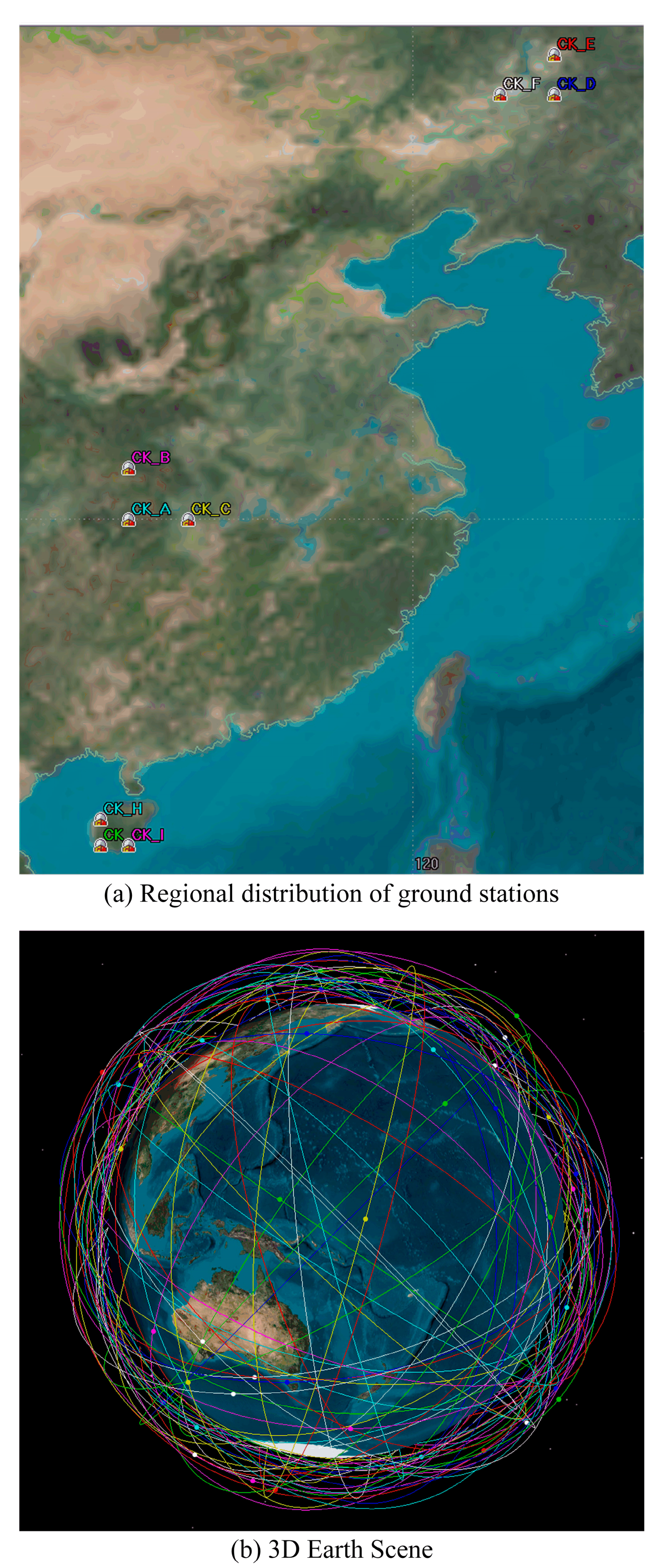
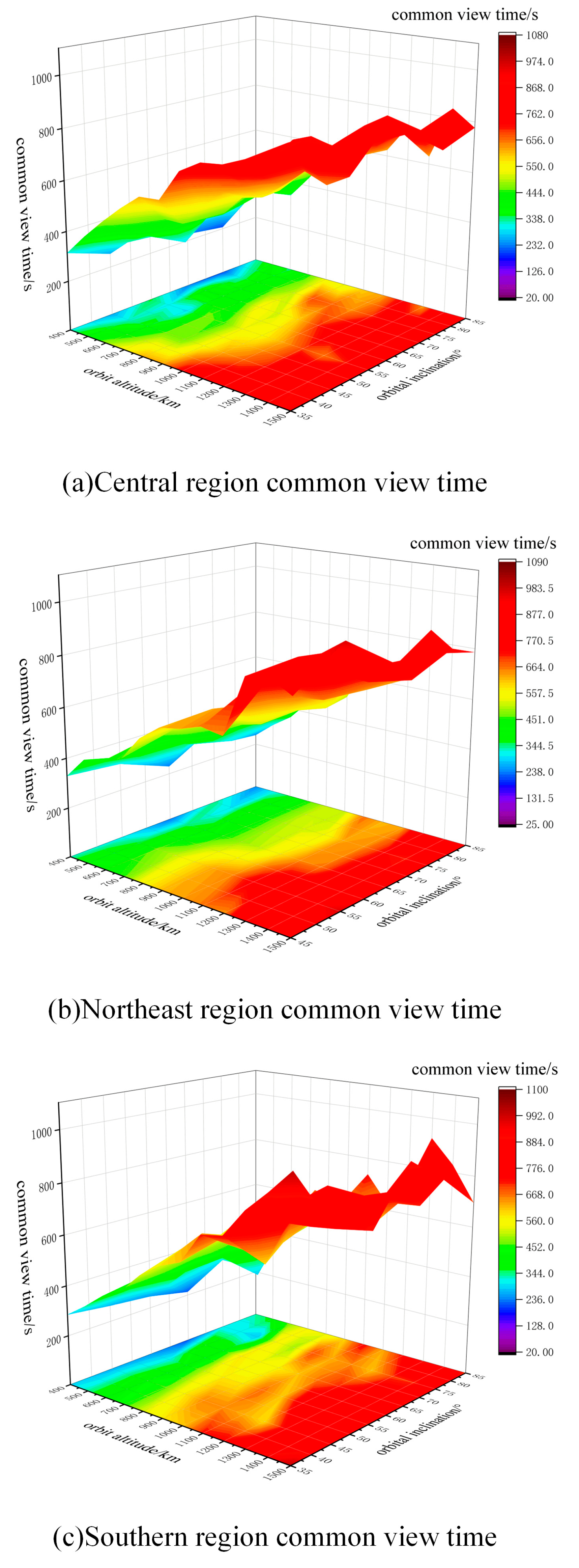
6.1. Simulation of Common View Time of CEI Ground Station to Satellite

Liao Chen et al. successfully achieved effective measurements of low-orbiting non-cooperative satellites using a CEI array with a baseline length of 500 m. The measurement data is divided into two segments, with the first segment having a tracking time of 317 s and the second segment having a tracking time of 213 s [45]. Therefore, in this paper, we use 213 s as the effective duration standard for simulating and analyzing the common view time of LEO satellites by the CEI array using Matlab (R2017a) and STK11 (AGI Systems Tool Kit). Since cooperative satellites differ from non-cooperative ones, the common view time required for measuring cooperative satellites is theoretically shorter. Therefore, the common view time standard set in this paper theoretically has a certain margin.
Figure 7 illustrates the common view time analysis of CEI arrays in various geographic locations. To conduct a comprehensive analysis, this paper selected three sets of CEI arrays located in northeastern, central, and southern China. Considering that the baseline length used in CEI measurements is typically less than 200 km [49], a 150 km baseline length was selected for northeastern China, a 200 km baseline length for the central region, and a 100 km baseline length for the southern region, based on the geographical area of each region. Table 4 and Table 5 respectively show the geographical location, baseline length and simulation parameters of CEI ground station, and Table 6 shows the satellite simulation parameters.
It is important to note that the CEI arrays located in the central and southern regions are situated at relatively low latitudes, which allows for a common view of satellites with an orbital inclination of 35°. However, the CEI arrays in the northeastern region are located at relatively high latitudes, resulting in a short common view time or even no common view time during the simulation. Therefore, the satellite orbital inclination corresponding to the array, which is in the northeast region, is above 45°.
The simulation results, presented in Figure 8, lead to the following conclusions:
(1) The common view time increases with the orbit altitude, which is consistent with the theoretical derivation in Section 5.1;
(2) The common view time of short baselines to satellites increases slightly compared to long baselines, and the increase is smaller, possibly due to the faster movement of LEO satellites;
(3) The common view time of CEI arrays in all three regions exceeds 213 s. Moreover, the duration limit set in this paper has a certain theoretical margin, indicating the feasibility of using CEI technology to measure LEO satellites in aspect of common view time.

6.2. Effect of Variable Parameters on Error Coefficient

This section specifically discusses the effect of the three parameters of satellite–station distance, baseline length, and angle of goniometry on the phase difference error coefficient and baseline error coefficient. When analyzing individual factors, the remaining factors are also taken into account in order to plot multiple curves for comparison. As it is difficult to change the frequency band of a satellite once it is in operation, the frequency of the satellite downlink signal is fixed at 13.5 GHz in this section to match the actual operation of most current or future LEO satellites.

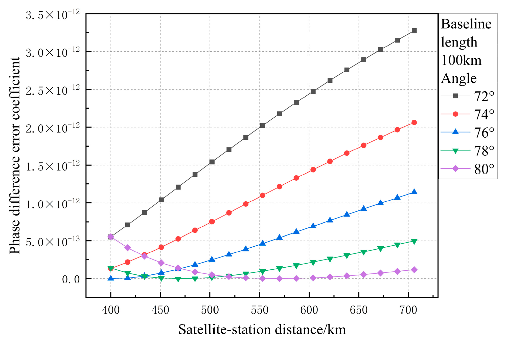
6.2.1. Effect of Satellite–Station Distance on Phase Difference Error Coefficient and Baseline Error Coefficient

The main parameters, additional parameters, and their variation ranges of the simulation in this section are listed in Table 7.
In order to intuitively explain the figures, Equations (13) and (14) provide specific equations for the phase difference error coefficient and baseline error coefficient, respectively.
1 ξ ( θ ) 2 = c ω R F ( B sin θ + B 2 sin θ cos θ L 2 B 2 sin 2 θ ) 2
ξ ( B ) ξ ( θ ) 2 = cos θ B sin 2 θ L 2 B 2 sin 2 θ B sin θ + B 2 sin θ cos θ L 2 B 2 sin 2 θ 2
In Figure 9, many curves are plotted to illustrate the variation in error coefficient with satellite–station distance. The range of satellite–station distance changes from 400 km to 1500 km. Different curves in the figure are added with different baseline lengths and goniometric angle information. The analysis leads to the following conclusions:
(1)
The phase difference error coefficient increases with the increase in satellite–station distance, and it increases more when the angle of measurement is lower. For example, when the angle of measurement is 30° and the baseline length is 100 km, the difference error coefficient increases by 32.4% compared to the minimum value of simulation change range. When the angle of measurement is 80° and the baseline length remains unchanged, the difference error coefficient only increases by 6.6%. This is mainly because, the smaller the angle of measurement, the shorter the equivalent length of the baseline, resulting in the greater impact of error sources on the angle measurement accuracy.
(2)
The increase in baseline length has little effect on the increase in difference error coefficient, and the different baseline length curves in the figure are basically parallel. This is because the baseline length of CEI is too short compared with the satellite–station distance;
(3)
The baseline error coefficient increases with the increase in satellite–station distance when the angle of measurement is below 70°, and the shorter the baseline length and lower the angle of measurement, the greater the increase. This is similar to the equivalent baseline length mentioned in (1). For example, when the baseline length is 80 km and the angle of measurement is 60°, the baseline error coefficient increases by 50.2% compared to the minimum value of simulation change range.
We analyzed the relationship between phase error coefficient and satellite–station distance when changing goniometric angle. As shown in Figure 10, as the angle continues to increase, the baseline error coefficient changes with the satellite–station distance in a concave function, with a minimum value. The larger the measuring angle, the greater the length of the satellite–station distance corresponding to the extreme point. This phenomenon is caused by the zero point of the molecule in Equation (14). This is one of the major differences between this model and the traditional measurement model.

6.2.2. Influence of Baseline Length on Phase Difference Error Coefficient and Baseline Error Coefficient

The main parameters, additional parameters, and their variation ranges of the simulation in this section are listed in Table 8.
In Figure 11, many curves are plotted to illustrate the variation of error coefficient with baseline length. The range of baseline length changes from 50 to 200 km. Different curves in the figure include information on satellite–station distances and measuring angles. The analysis reveals the following conclusions:
(1)
With an increase in baseline length, both the phase difference error coefficient and the baseline error coefficient decrease. This is consistent with the conclusion of the traditional “far-field” measurement model;
(2)
When the measuring angle is low, the impact of changes in baseline length on the error coefficient is significant. For example, when the measuring angle is 20° and the satellite–station distance is 600 km, the difference error coefficient decreases by 95.8%, while the baseline error coefficient decreases by 96.1%;
(3)
When the measuring angle is above 60°, there is little effect of increasing baseline lengths on reducing error coefficients;
(4)
Satellite–station distance has a relatively small impact on changes in baseline length and error coefficients, as seen from the overlapping curves in the figure.
Conclusions (2) and (3) are related to the equivalent baseline length mentioned in Section 6.2.1, and conclusion (4) is also related to the large difference between the baseline length and the satellite station distance mentioned above.

6.2.3. Influence of Measuring Angles on Phase Difference Error Coefficient and Baseline Error Coefficient

The main parameters, additional parameters, and their variation ranges of the simulation in this section are listed in Table 9.
As shown in Figure 12, many curves are plotted to illustrate the variation of error coefficient with measuring angles. The range of goniometric angles changes from 10 to 90°. Different curves in the figure include information on satellite–station distances and baseline lengths. The analysis reveals the following conclusions:
(1)
With an increase in measuring angle, both the phase difference error coefficient and the baseline error coefficient decrease. This is consistent with the conclusion of the traditional “far-field” measurement model;
(2)
When the baseline length is short, the impact of changes in measuring angle on errors is significant. For example, at a baseline length of 50 km and a satellite–station distance of 600 km, the phase difference error coefficient decreases by 96.5%, while the baseline error coefficient decreases by four orders of magnitude;
(3)
Changes in satellite–station distance have a relatively small impact on changing errors due to measuring angles, as seen from the overlapping curves in the figure. It can be understood that the measurement angle is mainly changed by the equivalent baseline length, and the satellite station distance has no effect on it.

6.2.4. Conclusion of the Simulation Analysis of Each Parameter Included in the Error Source

Based on the analysis of Section 6.2.1, Section 6.2.2 and Section 6.2.3, the following conclusions can be drawn:
(1)
When using CEI to measure angle information for low Earth orbit satellites, the length of baselines need not be excessively long and a baseline length greater than 150 km does not have a significant effect on error reduction. Additionally, shorter baselines are beneficial for achieving high precision time and frequency synchronization;
(2)
Angles should not be measured too low when measuring satellite position, taking into account interference such as echoes. The best goniometric angle is greater than 10°;
(3)
With an increase in the distance between the satellite and ground station, both the phase difference error coefficient and the baseline error coefficient will increase. As the unit angle error caused by higher orbit altitude leads to more significant positioning errors, attention should be paid to the introduced error increments due to increased satellite–station distances during high-precision measurements;
(4)
In situations where the angle is high, the baseline error coefficient may reach zero as it changes with the distance from the satellite and ground station. This condition can be utilized to achieve high-precision measurements of satellites.

6.3. The Theoretical Goniometric Accuracy of This Paper’s Model

Based on the literature, the baseline length error is typically below 1 m [41], and the phase difference measurement accuracy can achieve 2 ps. Therefore, as presented in Table 10, the goniometric accuracy of LEO satellite tracking measurement based on CEI technology can be calculated precisely using Equation (12).

7. Conclusions

CEI measurement techniques are primarily utilized for highly accurate measurements of HEO or deep space targets. However, as the demand for precise tracking of LEO satellites increases, the limitations of current measurement methods become more apparent. To address this issue, this paper proposes a goniometric model for LEO satellites based on “near-field” measurements, with the aim of achieving high-accuracy measurements of LEO satellites.
In the theoretical derivation part, firstly, based on the traditional CEI measurement model and comparing the application scenarios of LEO satellites, this paper proposes a CEI goniometric model for LEO satellites based on “near-field” measurements. Secondly, this paper derives the goniometric error equation of the model and briefly analyses the influence factors contained in each error source in the goniometric error formula. Finally, the common view of LEO satellites by the CEI ground station array is analyzed and the goniometric error formula is suitably simplified.
In the simulation analysis section, firstly, this paper simulates the common view time of LEO satellites with CEI ground station arrays. The results show that the different CEI arrays with a baseline length of 100 km in southern China, 150 km in Northeast China, and 200 km in Central China can meet the common view time requirements of the LEO satellite constructed in this paper, indicating the feasibility of using CEI technology to measure LEO satellites in aspect of common view time. Secondly, assuming a downlink signal frequency of 13.5 GHz, this paper simulates the impact of each factor in the angle measurement error formula on the angle measurement error coefficient. Finally, using the goniometric error formula, this paper provides the goniometric accuracy based on the different baseline lengths and different goniometric angles. Based on the condition of a baseline length of 240 km and an angle measurement angle of 80°, the angle measurement accuracy can reach 10 nrad.
In future research, the effect of downlink signal frequency on goniometric error can also be added to the simulation and verification part of this paper to provide reference for future LEO satellite signal frequency selection. Moreover, the research results of this paper could play the role of theoretical a priori and accuracy prediction in the future low-orbit satellite tracking measurement, and are expected to be applied in future low-orbit satellite high-precision tracking measurements, which could play a significant role in the increasing severe LEO target-monitoring and space situational awareness missions.

Author Contributions

E.Z. and Z.G. conceived the idea, E.Z., Z.G. and T.W. conducted the experiments, E.Z. and M.H. completed the original manuscript, E.Z., and T.W. analyzed the results, Y.J., W.Y., H.M. and X.S. checked the original manuscript. All authors reviewed the submitted manuscript. All authors have read and agreed to the published version of the manuscript.

Funding

This work was supported in part by Major Science and Technology Projects of Beijing under Grant: Z181100002918004, and in part by National Key Laboratory of Science and Technology on Space Microwave under Grant: HTKJ2021KL504012.

Data Availability Statement

Some of the data are publicly available at http://www.beidou.gov.cn/xt/gfxz/ (accessed on 3 May 2023) and http://www.csno-tarc.cn/system/constellation (accessed on 6 May 2023). The data presented in this study are available on request from the corresponding author.

Acknowledgments

The authors would like to thank the anonymous reviewers and editors for their valuable suggestions to improve the quality of this work.

Conflicts of Interest

The authors declare no conflict of interest.

References

  1. Farzan, F.; René, L. Multi-Constellation Software-Defined Receiver for Doppler Positioning with LEO Satellites. Sensors 2020, 20, 5866. [Google Scholar] [CrossRef]
  2. Mortlock, T.; Kassas, Z.M. Assessing Machine Learning for LEO Satellite Orbit Determination in Simultaneous Tracking and Navigation. In Proceedings of the 2021 IEEE Aerospace Conference (50100), Big Sky, MT, USA, 6–13 March 2021; pp. 1–8. [Google Scholar] [CrossRef]
  3. Kang, W.; Ahmed, E.M.; Chris, R. Integrity monitoring for precise orbit determination of LEO satellites. GPS Solut. 2021, 26, 32. [Google Scholar] [CrossRef]
  4. Darwish, T.; Kurt, G.K.; Yanikomeroglu, H.; Bellemare, M.; Lamontagne, G. LEO satellites in 5G and beyond networks: A review from a standardization perspective. IEEE Access 2022, 10, 35040–35060. [Google Scholar] [CrossRef]
  5. Zhou, J.; Bo, Q.; Sun, L.; Wang, J.; Yan, X. Routing Strategy for LEO Satellite Networks Based on Membership Degree Functions. Secur. Commun. Netw. 2020, 2020, 8822985. [Google Scholar] [CrossRef]
  6. McDowell, J.C. The Low Earth Orbit Satellite Population and Impacts of the SpaceX Starlink Constellation. Astrophys. J. Lett. 2020, 892, L36. [Google Scholar] [CrossRef] [Green Version]
  7. Tao, H.; Zhu, Q.; Che, X.; Li, X.; Man, W.; Zhang, Z.; Zhang, G. Impact of Mega Constellations on Geospace Safety. Aerospace 2022, 9, 402. [Google Scholar] [CrossRef]
  8. Al Homssi, B.; Al-Hourani, A.; Wang, K.; Conder, P.; Kandeepan, S.; Choi, J.; Allen, B.; Moores, B. Next generation mega satellite networks for access equality: Opportunities, challenges, and performance. IEEE Commun. Mag. 2022, 60, 18–24. [Google Scholar] [CrossRef]
  9. Duan, T.; Dinavahi, V. Starlink space network-enhanced cyber–physical power system. IEEE Trans. Smart Grid 2021, 12, 3673–3675. [Google Scholar] [CrossRef]
  10. Si, Y.; Zhang, E.; Zhang, W.; Ma, H.; Wu, T. A Survey on the Development of Low-Orbit Mega-Constellation and Its TT&C Methods. In Proceedings of the 2022 5th International Conference on Information Communication and Signal Processing (ICICSP), Shenzhen, China, 16–18 September 2022; pp. 324–332. [Google Scholar] [CrossRef]
  11. Chaudhry, A.U.; Yanikomeroglu, H. Laser intersatellite links in a starlink constellation: A classification and analysis. IEEE Veh. Technol. Mag. 2021, 16, 48–56. [Google Scholar] [CrossRef]
  12. Gallozzi, S.; Scardia, M.; Maris, M. Concerns about ground based astronomical observations: A step to safeguard the astronomical sky. arXiv 2020, arXiv:2001.10952. [Google Scholar] [CrossRef]
  13. Henri, Y. The OneWeb satellite system. In Handbook of Small Satellites: Technology, Design, Manufacture, Applications, Economics and Regulation; Springer: Berlin/Heidelberg, Germany, 2020; pp. 1–10. [Google Scholar] [CrossRef]
  14. Radtke, J.; Kebschull, C.; Stoll, E. Interactions of the space debris environment with mega constellations—Using the example of the OneWeb constellation. Acta Astronaut. 2017, 131, 55–68. [Google Scholar] [CrossRef]
  15. Zong, P.; Kohani, S. Design of LEO constellations with inter-satellite connects based on the performance evaluation of the three constellations SpaceX, OneWeb and Telesat. Korean J. Remote Sens. 2021, 37, 23–40. [Google Scholar]
  16. Xu, Y.; Zhang, Y.; Wang, Z.; He, Y.; Fan, L. Self-Organizing Control of Mega Constellations for Continuous Earth Observation. Remote Sens. 2022, 14, 5896. [Google Scholar] [CrossRef]
  17. Markovitz, O.; Segal, M. Advanced Routing Algorithms for Low Orbit Satellite Constellations. In Proceedings of the ICC 2021-IEEE International Conference on Communications, Montreal, QC, Canada, 14–23 June 2021; pp. 1–6. [Google Scholar] [CrossRef]
  18. Matricciani, E. Geocentric spherical surfaces emulating the geostationary orbit at any latitude with zenith links. Future Internet 2020, 12, 16. [Google Scholar] [CrossRef] [Green Version]
  19. Meng, Y.; Bian, L.; Han, L.; Lei, W.; Yan, T.; He, M.; Li, X. A global navigation augmentation system based on LEO communication constellation. In Proceedings of the 2018 European Navigation Conference (ENC), Gothenburg, Sweden, 14–17 May 2018; pp. 65–71. [Google Scholar] [CrossRef]
  20. Chen, L.; Lu, X.; Shen, N.; Wang, L.; Zhuang, Y.; Su, Y.; Li, D.; Chen, R. Signal acquisition of Luojia-1A low earth orbit navigation augmentation system with software defined receiver. Geo-Spat. Inf. Sci. 2022, 25, 47–62. [Google Scholar] [CrossRef]
  21. Yue, F.; Cui, Z.; Li, S.; Jing, H.; Zhang, S.; Wang, M. A Satellite Augmentation System based on LEO mega-constellation. In Proceedings of the 2022 International Conference on Artificial Intelligence, Information Processing and Cloud Computing (AIIPCC), Kunming, China, 19–21 August 2022; pp. 221–225. [Google Scholar] [CrossRef]
  22. Liu, G.-P.; Zhang, S. A Survey on Formation Control of Small Satellites. Proc. IEEE 2018, 106, 440–457. [Google Scholar] [CrossRef]
  23. Yu, B.; Huang, Z.; Geng, L.; Jin, D. Stability and ground experiments of a spinning triangular tethered satellite formation on a low earth orbit. Aerosp. Sci. Technol. 2019, 92, 595–604. [Google Scholar] [CrossRef]
  24. Brown, A.; Nguyen, D.; Silva, T.; Redd, J.; Linan, A. PNT as a Service (PNTaaS): Providing a Resilient Back-Up to GPS by Leveraging Broadband Satellite Constellations and Ground Infrastructure. In Proceedings of the 2023 IEEE/ION Position, Location and Navigation Symposium (PLANS), Monterey, CA, USA, 24–27 April 2023; pp. 388–398. [Google Scholar] [CrossRef]
  25. Schmidt, T.D.; Schuldt, T.; Michalak, G.; Surof, J.; Poliak, J.; Giorgi, G.; Braxmaier, C.; Meurer, M.; Günther, C. Optical Technologies for Future Global Navigation Satellite Systems. In Proceedings of the 2023 IEEE/ION Position, Location and Navigation Symposium (PLANS), Monterey, CA, USA, 24–27 April 2023; pp. 311–317. [Google Scholar] [CrossRef]
  26. Zhang, X.; Ma, F. Review of the development of LEO navigation-augmented GNS. Acta Geod. Cartogr. Sin. 2019, 48, 1073–1087. [Google Scholar] [CrossRef]
  27. Ma, F. Research on the Key Technologies for GNSS Precise Positioning Augmented with LEO Constellation. Ph.D. Thesis, Wuhan University, Wuhan, China, 2018. [Google Scholar]
  28. Ke, M.; Lv, J.; Zhu, M.; Wei, W.; Du, F. The Effect of LEO Satellite Orbital Error on Combined GPS and LEO Precise Point Positioning. In Proceedings of the 7th Annual Chinese Satellite Navigation Academic Conference, Changsha, Hunan, China, 18 May 2016; pp. 77–81. [Google Scholar]
  29. Li, X.; Ye, X.; Liu, W.; Wang, F. Precision single-point positioning of BDS/GPS/LEO with Fourier level fitting LEO orbit error. Glob. Position. Syst. 2021, 46, 16–24. [Google Scholar] [CrossRef]
  30. Xing, Y.; Cao, X.; Zhang, S.; Guo, H.; Wang, F. Relative position and attitude estimation for satellite formation with coupled translational and rotational dynamics. Acta Astronaut. 2010, 67, 455–467. [Google Scholar] [CrossRef]
  31. Wang, J.; Li, S.; Liu, C.; Wang, Z. Relative Position Keeping for Precise Formation Flying Using Linear Momentum Exchange. J. Guid. Control Dyn. 2023, 46, 978–988. [Google Scholar] [CrossRef]
  32. Hu, Y.; Bai, X.; Chen, L.; Yan, H. A new approach of orbit determination for LEO satellites based on optical tracking of GEO satellites. Aerosp. Sci. Technol. 2019, 84, 821–829. [Google Scholar] [CrossRef]
  33. Choi, J.; Jo, J.H.; Yim, H.-S.; Choi, E.-J.; Cho, S.; Park, J.-H. Optical tracking data validation and orbit estimation for sparse observations of satellites by the OWL-Net. Sensors 2018, 18, 1868. [Google Scholar] [CrossRef] [PubMed] [Green Version]
  34. Sun, X.; Shi, H.; Ji, Y. Passive measurement for synchronous orbit satellite with short base-lines interference of several stations. In Proceedings of the 2007 China Conference on Intelligent Automation, Lanzhou, China, 26–31 July 2007; pp. 1147–1152. [Google Scholar]
  35. Wilkinson, M.; Schreiber, U.; Procházka, I.; Moore, C.; Degnan, J.; Kirchner, G.; Zhongping, Z.; Dunn, P.; Shargorodskiy, V.; Sadovnikov, M. The next generation of satellite laser ranging systems. J. Geod. 2019, 93, 2227–2247. [Google Scholar] [CrossRef]
  36. Drożdżewski, M.; Sośnica, K. Tropospheric and range biases in Satellite Laser Ranging. J. Geod. 2021, 95, 100. [Google Scholar] [CrossRef]
  37. Ren, S.; Yang, X.; Wang, R.; Liu, S.; Sun, X. The Interaction between the LEO Satellite Constellation and the Space Debris Environment. Appl. Sci. 2021, 11, 9490. [Google Scholar] [CrossRef]
  38. Thurman, S. Information content of a single pass of phase-delay data from a short baseline connected element interferometer. Telecommun. Data Acquis. Rep. 1990, 26–38. [Google Scholar]
  39. Hong, J.C.; Lu, W.T.; Yang, W.G.; Wang, L.B. Processing and analysis of connected interferometric DOR signals based on frequency-phase estimation. J. Telem. Track. Command 2013, 34, 52–57. [Google Scholar] [CrossRef]
  40. Edwards, C. Goldstone intracomplex connected element interferometry. Telecommun. Data Acquis. Rep. 1990, 1–12. [Google Scholar]
  41. Du, L. Research on Precision Orbiting Technology of GEO Satellite. Ph.D. Thesis, PLA Information Engineering University, Zhengzhou, China, 2006. [Google Scholar]
  42. Liu, Z.; Du, L.; Zhu, Y.; Qian, Z.; Wang, J.; Liang, S. Investigation on GEO satellite orbit determination based on CEI measurements of short baselines. J. Navig. 2019, 72, 1585–1601. [Google Scholar] [CrossRef]
  43. Gao, Z.; Jiao, Y.; Teng, F.; Mao, F.; Li, C.; Wang, Y.; Si, Y.; Liu, R. A high-precision frequency estimation method for CEI signals of high-orbit satellites. In Proceedings of the GLOBECOM 2022—2022 IEEE Global Communications Conference, Rio de Janeiro, Brazil, 4–8 December 2022; pp. 3156–3161. [Google Scholar] [CrossRef]
  44. Sakamoto, Y.; Nishio, M. Orbit determination using radio interferometer of small-diameter antennas for LEO satellites. IEEE Trans. Aerosp. Electron. Syst. 2011, 47, 2111–2118. [Google Scholar] [CrossRef]
  45. Chen, L.; Lu, W.; Cao, J.; Shi, X.; Liu, Y.; Ren, T.; Ping, J. Technical Verification of Low Orbit Non-Cooperative Satellite Orbit Measurement and Determination Based on CEI System. Space Debris Res. 2021, 21, 30–36. [Google Scholar] [CrossRef]
  46. Li, X. Research on CEI-Based Precise Orbit Determination. Master’s Thesis, PLA Information Engineering University, Zhengzhou, China, 2009. [Google Scholar]
  47. Matricciani, E. A relationship between phase delay and attenuation due to rain and its applications to satellite and deep-space tracking. IEEE Trans. Antennas Propag. 2009, 57, 3602–3611. [Google Scholar] [CrossRef]
  48. Kawase, S.; Sawada, F. Interferometric tracking for close geosynchronous satellites. J. Astronaut. Sci. 1999, 47, 151–163. [Google Scholar] [CrossRef]
  49. Jia, H. Research on Passive Satellite Orbit Determination Technology Based on Interferometry. Master’s Thesis, University of Chinese Academy of Sciences (National Time Service Center, Chinese Academy of Sciences), Beijing, China, 2022. [Google Scholar]
  50. Schmidt, R. Multiple emitter location and signal parameter estimation. IEEE Trans. Antennas Propag. 1986, 34, 276–280. [Google Scholar] [CrossRef] [Green Version]
  51. Li, H.; Huang, L.; Hao, W.H. Interferometry Techniques for Deep Space Navigation; Tsinghua University Press: Beijing, China, 2022; pp. 133–138. [Google Scholar]
  52. Rosengren, M.; De Vicente-Olmedo, J.; Pedersen, F. Keeping track of geostationary satellites—A novel and less costly approach. ESA Bull. 2004, 119, 64–68. [Google Scholar]
  53. Del Portillo, I.; Cameron, B.G.; Crawley, E.F. A technical comparison of three low earth orbit satellite constellation systems to provide global broadband. Acta Astronaut. 2019, 159, 123–135. [Google Scholar] [CrossRef]
Figure 1. Thesis structure.
Electronics 12 03385 g001
Figure 2. The general scenario of this paper.
Electronics 12 03385 g002
Figure 3. Traditional CEI goniometric model for HEO satellites.
Electronics 12 03385 g003
Figure 4. Comparison of traditional models for wave range errors of HEO and LEO satellites.
Electronics 12 03385 g004
Figure 5. CEI goniometric model for LEO satellite scenes.
Electronics 12 03385 g005
Figure 6. Schematic diagram of the common view time of satellites at different orbit altitudes by ground stations with different baseline lengths.
Electronics 12 03385 g006
Figure 7. (a) Distribution of ground stations; (b) Simulation scenarios constructed using STK.
Electronics 12 03385 g007
Figure 8. (a) Common view time in the central region; (b) Common view time in northeast region; (c) Common view time in southern region.
Electronics 12 03385 g008
Figure 9. (a) The curve of the phase difference error coefficient varying with the distance of the satellite and station, with different baseline length information attached; (b) The curve of the phase difference error coefficient varying with the distance of the satellite and station, with different angle information attached; (c) The curve of the baseline error coefficient varying with the distance of the satellite and station, with different baseline length information attached; (d) The curve of the baseline error coefficient varying with the distance of the satellite and station, with different angle information attached.
Electronics 12 03385 g009
Figure 10. Variation curve of phase difference error coefficient with the distance of the satellite and station when the goniometric angle is greater than 70 degrees.
Electronics 12 03385 g010
Figure 11. (a) Variation curve of phase difference error coefficient with baseline length, with different goniometric angle information attached; (b) Variation curve of phase difference error coefficient with baseline length, with different satellite–station distance information attached; (c) Variation curve of baseline error coefficient with baseline length, with different goniometric angle information attached; (d) Variation curve of baseline error coefficient with baseline length, with different satellite–station distance information attached.
Electronics 12 03385 g011
Figure 12. (a) Variation curve of phase difference error coefficient with goniometric angle, with different baseline length information attached; (b) Variation curve of phase difference error coefficient with goniometric angle, with different satellite–station distance information attached; (c) Variation curve of baseline error coefficient with goniometric angle, with different baseline length information attached; (d) Variation curve of baseline error coefficient with goniometric angle, with different satellite–station distance information attached.
Electronics 12 03385 g012
Table 1. Description of symbols.
SymbolsDescription
B Baseline length of CEI array
θ Two-dimensional plane angle between the satellite and ground station line and the CEI baseline
L Distance between satellite and ground station
c Speed of light
φ Phase difference between two ground stations receiving downlink signals from the same satellite
ω R F Satellite downlink signal frequency
σ θ Goniometric error
σ B Baseline length error
σ R F Downlink signal frequency error
σ φ Phase difference error
σ L Satellite–station distance error
Table 2. Comparison of the wave range errors of traditional CEI goniometric models in two scenarios: HEO and LEO.
Satellite/ConstellationOrbit Altitude/km“Far-Field” Model Wave Range Error/m *Ratio of Orbit Altitude to Baseline Length *
GPS-PPS20,2000.394040
Viasat36,0000.237200
Starlink55014.8110
Oneweb12006.8240
* The angle for calculating the wave range error is 60° and the CEI baseline length is 5 km.
Table 3. Parameters of the main LEO satellite constellations.
ConstellationTelesatOneWebStarlinkGW
Parameters
Orbit altitude and
Orbital inclination
1000 km (99.5°)
1248 km (37.4°)
1200 km (87.9°)1150 km (53°)
1110 km (53.8°)
1130 km (74°)
1275 km (81°)
1325 km (70°)
590 km (85°)
600 km (50°)
508 (55°)
1145 (30–60°)
Downlink signal
frequency/GHz
18.513.513.5
Bandwidth0.250.250.25
Table 4. Longitude and latitude coordinates of ground stations in three areas and baseline length of each array.
RegionsLatitude, Longitude and Array Baseline Length
of Ground Stations
Central Regionground station A(110° E, 30° N)
ground station B(110° E, 31.8° N)
ground station C(112.1° E, 30° N)
baseline length200 km
Northeast Regionground station D(125° E, 45° N)
ground station E(125° E, 46.4° N)
ground station F(123.1° E, 45° N)
baseline length150 km
Southern Regionground station G(109° E, 18.5° N)
ground station H(109° E, 19.4° N)
ground station I(110° E, 18.5° N)
baseline length100 km
Table 5. Ground station simulation parameters.
ParametersRange of Variation
Range of antenna operating angles10–170°
Operating frequency bandKu (13.2–13.8 GHz)
K (18.2–18.8 GHz)
Antenna gainKu-band, G 50.65 dBi
K-band, G 57.25 dBi
Noise temperatureKu band 78.6 K
K-band 84.2 K
Low noise amplifier gainKu band 45 dB
K-band 45 dB
Paraflap characteristicsKu/K band first flap level −14 dB below main flap level
Tracking methodprogram tracking, step tracking
Tracking accuracy<1/10 half-power beamwidth
Table 6. Satellite simulation parameters.
ParametersRange of Variation
Orbit altitude400–1500 km with 100 km interval change
Orbital inclinationCentral region, southern region: 35–85° with 10° interval variation
Northeast region: 45–85° with 10° interval change
Ascending node equinox0–360° range randomly selected
Perigee angleNo restrictions
True near point angleNo restrictions
Simulation time4 June 2023 0:00–5 June 2023 0:00, 24 h in total
Table 7. Variation range of simulation parameters in Section 6.2.1.
Main Simulation
Variable and Variation Range
Range of
Variation in
Additional
Information
The Serial Number of Figures and the Type of Error Coefficient It Plots
(a)
Phase Difference Error
(b)
Phase Difference Error
(c)
Baseline Error
(d)
Baseline Error
Satellite–station
distance
400–1500 km
goniometric
angle/°
6030/40/50/60/806030/40/50/60/70
Baseline length/km80/90/100/120/15010080/90/100/120/150100
Table 8. Variation range of simulation parameters in Section 6.2.2.
Main Simulation Variable and Variation RangeRange of
Variation in
Additional
Information
The Serial Number of Figures and the Type of Error Coefficient It Plots
(a)
Phase Difference Error
(b)
Phase Difference Error
(c)
Baseline Error
(d)
Baseline Error
baseline length
50–200 km
goniometric
angle/°
20/40/60/906020/40/60/9060
satellite–station distance/km600400/700/1000/1500600400/700/1000/1500
Table 9. Variation range of simulation parameters in Section 6.2.3.
Main Simulation Variable and Variation RangeRange of
Variation in
Additional
Information
The Serial Number of Figures and the Type of Error Coefficient It Plots
(a)
Phase Difference Error
(b)
Phase Difference Error
(c)
Baseline Error
(d)
Baseline Error
goniometric angle
10–90°
baseline length/km50/70/100/15010050/70/100/150100
satellite–station distance/km600400/700/1000/1500600400/700/1000/1500
Table 10. CEI theoretical angle measurement accuracy of different baseline lengths and angles.
Angle/°4050607080
Baseline Length/km
1015,188 *10,717840771616541
2037402645208117781629
50572407323279258
10013396766763
1208965524643
1604735282524
2002921171615
2401914121110
* The unit of angle measurement accuracy is nrad.
Disclaimer/Publisher’s Note: The statements, opinions and data contained in all publications are solely those of the individual author(s) and contributor(s) and not of MDPI and/or the editor(s). MDPI and/or the editor(s) disclaim responsibility for any injury to people or property resulting from any ideas, methods, instructions or products referred to in the content.

