

Satellite-Assisted Disrupted Communications: IoT Case Study

Abstract
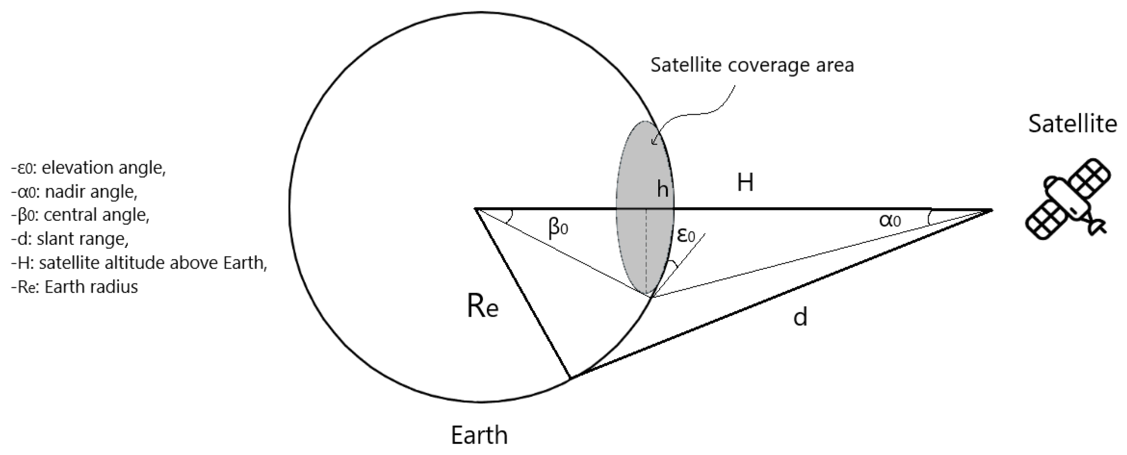
:1. Introduction
- We analyzed the influence of the satellites’ design parameters, e.g., the number of ground stations, satellites, planes, and inter-satellite links, on the reliability (i.e., the RTT and packet loss) of the ground-to-satellite connections.
- We demonstrated two scenarios involving the utilization of LEO satellite constellations for the communication among the IoT devices.
- We performed a Case Study, in which we integrated the real data obtained from the Smart Santander sensors into OMNeT++ to examine the transmission to the testbeds located in the EU and the U.S.
2. Related Work

| Research Area | Papers | Focus | OMNeT++ |
|---|---|---|---|
| Smart Cities | [11,12,13,14,15,16,17] | Implementations for VANET, V2X communications & Integration with other frameworks e.g., SUMO, VEINS | Yes |
| IoT relays | [18,19,20,21,22,23] | UAV/Drone frameworks for WSNs, security, energy consumption | Yes |
| Space related | [24,25,26,27,28,29,30] | Examine protocols and standards impact in the context of satellite communications e.g., routing, CSMA/CA etc. | Yes |
| Space related | [4,5,31,32,33,34,35,36,37,38,39] | Impact and optimization of space design parameters on throughput, end-to-end latency etc. | No |
| DTN related | [3,7,32,40,41,42,43,44,45,46] | DTN communication protocols and solutions in dense environments | No |
3. Methodology
4. Experiments
4.1. Experimentation Parameters
4.2. Experimentation Scenarios
4.2.1. Scenario 1: IoT Sensors for EU-EU and EU-U.S. Communication
4.2.2. Scenario 2: IoT Sensors from Smart Santander Transmitting to Existing TestBeds
5. Results
5.1. Scenario 1: IoT Sensors for EU-EU and EU-U.S. Communication
5.2. Scenario 2: IoT Sensors from Smart Santander Transmitting to Transmitting to Existing TestBeds
6. Discussion
7. Conclusions
Author Contributions
Funding
Data Availability Statement
Acknowledgments
Conflicts of Interest
References
- De Sanctis, M.; Cianca, E.; Araniti, G.; Bisio, I.; Prasad, R. Satellite Communications Supporting Internet of Remote Things. IEEE Internet Things J. 2016, 3, 113–123. [Google Scholar] [CrossRef]
- Burleigh, S.C.; De Cola, T.; Morosi, S.; Jayousi, S.; Cianca, E.; Fuchs, C.; Dat, P.T. From Connectivity to Advanced Internet Services: A Comprehensive Review of Small Satellites Communications and Networks. Wirel. Commun. Mob. Comput. 2019, 2019, 6243505. [Google Scholar] [CrossRef]
- Burleigh, S.; Cerf, V.G.; Crowcroft, J.; Tsaoussidis, V. Space for Internet and Internet for space. Ad Hoc Netw. 2014, 23, 80–86. [Google Scholar] [CrossRef]
- del Portillo, I.; Cameron, B.G.; Crawley, E.F. A technical comparison of three low earth orbit satellite constellation systems to provide global broadband. Acta Astronaut. 2019, 159, 123–135. [Google Scholar] [CrossRef]
- Chen, Q.; Yang, L.; Liu, X.; Guo, J.; Wu, S.; Chen, X. Multiple gateway placement in large-scale constellation networks with inter-satellite links. Int. J. Satell. Commun. Netw. 2021, 39, 47–64. [Google Scholar] [CrossRef]
- Avian, V. Leosatellites. Available online: https://github.com/Avian688/leosatellites (accessed on 14 April 2022).
- Kim, I.; Baek, J.; Han, S.; Han, Y. The Performance Analysis of Multi-Hop Relay DTN Communication System in Interplanetary Network. In Proceedings of the 2020 International Conference on Information and Communication Technology Convergence (ICTC), Jeju, Republic of Korea, 21–23 October 2020; pp. 1136–1141. [Google Scholar] [CrossRef]
- Lam, K.Y.; Mitra, S.; Gondesen, F.; Yi, X. ANT-Centric IoT Security Reference Architecture—Security-by-Design for Satellite-Enabled Smart Cities. IEEE Internet Things J. 2022, 9, 5895–5908. [Google Scholar] [CrossRef]
- Kapovits, A.; Corici, M.I.; Gheorghe-Pop, I.D.; Gavras, A.; Burkhardt, F.; Schlichter, T.; Covaci, S. Satellite communications integration with terrestrial networks. China Commun. 2018, 15, 22–38. [Google Scholar] [CrossRef]
- INET (v4.3). Available online: https://inet.omnetpp.org/ (accessed on 12 April 2022).
- Arellano, W.; Mahgoub, I. TrafficModeler extensions: A case for rapid VANET simulation using, OMNET++, SUMO, and VEINS. In Proceedings of the 2013 High Capacity Optical Networks and Emerging/Enabling Technologies, Magosa, Cyprus, 11–13 December 2013; pp. 109–115. [Google Scholar] [CrossRef]
- Agarwal, D.; Sharma, S.A.; Pandey, K. N-Hop broadcast and Street Broadcast Reduction algorithm using OMNeT++ and Google Earth plugin. In Proceedings of the 2015 Eighth International Conference on Contemporary Computing (IC3), Noida, India, 20–22 August 2015; pp. 542–547. [Google Scholar] [CrossRef]
- Mavromatis, I.; Tassi, A.; Piechocki, R.J.; Nix, A. Poster: Parallel Implementation of the OMNeT++ INET Framework for V2X Communications. In Proceedings of the 2018 IEEE Vehicular Networking Conference (VNC), Taipei, Taiwan, 5–7 December 2018; pp. 1–2. [Google Scholar] [CrossRef]
- Zuo, J.; Wang, Y.; Liu, Y.; Zhang, Y. Performance Evaluation of Routing Protocol in VANET with Vehicle-Node Density. In Proceedings of the 2010 6th International Conference on Wireless Communications Networking and Mobile Computing (WiCOM), Chengdu, China, 23–25 September 2010; pp. 1–4. [Google Scholar] [CrossRef]
- Singh, A.V.; Bhasin, J.S. A Variable Speed Limit (VSL) Based Model for Advanced Traffic Management through VANETs. In Proceedings of the 2016 30th International Conference on Advanced Information Networking and Applications Workshops (WAINA), Crans-Montana, Switzerland, 23–25 March 2016; pp. 533–538. [Google Scholar] [CrossRef]
- Ahmad, N.A.; Subramaniam, S.K.; Desa, J.M. Increasing packet delivery in Ad Hoc On-Demand Distance Vector (AODV) routing protocol. In Proceedings of the 2008 International Conference on Computer and Communication Engineering, Kuala Lumpur, Malaysia, 13–15 May 2008; pp. 505–509. [Google Scholar] [CrossRef]
- Karthikeyan, B.; Kanimozhi, N.; Ganesh, S.H. Analysis of Reactive AODV Routing Protocol for MANET. In Proceedings of the 2014 World Congress on Computing and Communication Technologies, Trichirappalli, India, 27 February–1 March 2014; pp. 264–267. [Google Scholar] [CrossRef]
- Trotta, A.; di Felice, M.; Bononi, L.; Natalizio, E.; Perilli, L.; Scarselli, E.F.; Cinotti, T.S.; Canegallo, R. BEE-DRONES: Energy-efficient Data Collection on Wake-Up Radio-based Wireless Sensor Networks. In Proceedings of the IEEE INFOCOM 2019—IEEE Conference on Computer Communications Workshops (INFOCOM WKSHPS), Paris, France, 29 April–2 May 2019; pp. 547–553. [Google Scholar] [CrossRef]
- Pu, C.; Zhu, P. Defending against Flooding Attacks in the Internet of Drones Environment. In Proceedings of the 2021 IEEE Global Communications Conference (GLOBECOM), Madrid, Spain, 7–11 December 2021; pp. 1–6. [Google Scholar] [CrossRef]
- Jagarlapudi, H.N.S.S.; Lim, S.; Chae, J.; Choi, G.S.; Pu, C. Drone Helps Privacy: Sky Caching Assisted k-Anonymity in Spatial Querying. IEEE Syst. J. 2022, 16, 6360–6370. [Google Scholar] [CrossRef]
- Anggadjaja, E.; Mcloughlin, I. Point-to-Point OMNeT++ Based Simulation of Reliable Transmission Using Realistic Segmentation and Reassembly with Error Control. In Proceedings of the 2010 Second International Conference on Advances in Computing, Control, and Telecommunication Technologies, Jakarta, Indonesia, 2–3 December 2010; pp. 125–128. [Google Scholar] [CrossRef]
- Yang, X.; Liu, K.; Cui, Y.; Zhang, J. Modeling and simulation for Maritime Surveillance Sensor Networks. In Proceedings of the 2010 10th International Symposium on Communications and Information Technologies, Tokyo, Japan, 26–29 October 2010; pp. 215–219. [Google Scholar] [CrossRef]
- Woo, W.H.; Annur, R.; Ponnusamy, V. Performance Evaluation for Relay Selection on Device-to-Device (D2D) Communications in Rayleigh Fading. In Proceedings of the 2021 3rd International Conference on Advancements in Computing (ICAC), Colombo, Sri Lanka, 9–11 December 2021; pp. 140–145. [Google Scholar] [CrossRef]
- Del Re, E.; Pucci, R.; Ronga, L.S. IEEE802.15.4 Wireless Sensor Network in Mars exploration scenario. In Proceedings of the 2009 International Workshop on Satellite and Space Communications, Siena, Italy, 9–11 September 2009; pp. 284–288. [Google Scholar] [CrossRef]
- Boussemart, V.; Brandt, H. A tool for satellite communications Advanced DVB-RCS/DVB-S2 system and protocol simulator. In Proceedings of the 2008 10th International Workshop on Signal Processing for Space Communications, Rhodes, Greece, 6–8 October 2008; pp. 1–5. [Google Scholar] [CrossRef]
- Cawood, A.D.; Wolhuter, R. Comparison and optimisation of CSMA/CA back-off distribution functions for a low earth orbit satellite link. In Proceedings of the AFRICON 2007, Windhoek, South Africa, 26–28 September 2007; pp. 1–8. [Google Scholar] [CrossRef]
- Zha, P.; Long, C.; Wu, J.; Li, S. Satellite Lifetime Predicted Greedy Perimeter Stateless Routing Protocol for LEO Satellite Network. In Proceedings of the 2020 Chinese Automation Congress (CAC), Shanghai, China, 6–8 November 2020; pp. 5102–5107. [Google Scholar] [CrossRef]
- Ennis, S.; Dukes, J. CubeSat networks: Balancing power with satellite-to-ground data throughput. In Proceedings of the 2018 IEEE Aerospace Conference, Big Sky, MT, USA, 3–10 March 2018; pp. 1–18. [Google Scholar] [CrossRef]
- Li, X.; Wang, L.; Liu, L.; Hu, X.; Xu, F.; Chen, J. OMNeT++ and Mixim-based protocol simulator for satellite network. In Proceedings of the 2011 Aerospace Conference, Big Sky, MT, USA, 5–12 March 2011; pp. 1–9. [Google Scholar] [CrossRef]
- Dewangan, N.K.; Ghosh, P.; Rai, J.K. Satellite Data Network Jamming Attack and Prevention Simulation Model with OMNET++. In Proceedings of the 2018 Second International Conference on Intelligent Computing and Control Systems (ICICCS), Madurai, India, 14–15 June 2018; pp. 701–707. [Google Scholar] [CrossRef]
- Deng, R.; Di, B.; Zhang, H.; Song, L. Ultra-Dense LEO Satellite Constellation Design for Global Coverage in Terrestrial-Satellite Networks. In Proceedings of the GLOBECOM 2020–2020 IEEE Global Communications Conference, Taipei, Taiwan, 7–11 December 2020; pp. 1–6. [Google Scholar] [CrossRef]
- Radhakrishnan, R.; Edmonson, W.W.; Afghah, F.; Rodriguez-Osorio, R.M.; Pinto, F.; Burleigh, S.C. Survey of Inter-Satellite Communication for Small Satellite Systems: Physical Layer to Network Layer View. IEEE Commun. Surv. Tutorials 2016, 18, 2442–2473. [Google Scholar] [CrossRef]
- Chen, Q.; Giambene, G.; Yang, L.; Fan, C.; Chen, X. Analysis of Inter-Satellite Link Paths for LEO Mega-Constellation Networks. IEEE Trans. Veh. Technol. 2021, 70, 2743–2755. [Google Scholar] [CrossRef]
- Toyoshima, M. Recent Trends in Space Laser Communications for Small Satellites and Constellations. J. Light. Technol. 2021, 39, 693–699. [Google Scholar] [CrossRef]
- Bhattacherjee, D.; Singla, A. Network Topology Design at 27,000 km/h. In Proceedings of the CoNEXT ’19: The 15th International Conference on emerging Networking EXperiments and Technologies, Orlando, FL, USA, 9–12 December 2019; pp. 341–354. [Google Scholar] [CrossRef]
- Bhattacherjee, D.; Aqeel, W.; Bozkurt, I.N.; Aguirre, A.; Chandrasekaran, B.; Godfrey, P.B.; Laughlin, G.; Maggs, B.; Singla, A. Gearing up for the 21st Century Space Race. In Proceedings of the HotNets ’18: 17th ACM Workshop on Hot Topics in Networks, Redmond, WA, USA, 15–16 November 2018; pp. 113–119. [Google Scholar] [CrossRef]
- Handley, M. Using Ground Relays for Low-Latency Wide-Area Routing in Megaconstellations. In Proceedings of the HotNets ’19: 18th ACM Workshop on Hot Topics in Networks, Princeton, NJ, USA, 13–15 November 2019; pp. 125–132. [Google Scholar] [CrossRef]
- Handley, M. Delay is Not an Option: Low Latency Routing in Space. In Proceedings of the HotNets ’18: 17th ACM Workshop on Hot Topics in Networks, Redmond, WA, USA, 15–16 November 2018; pp. 85–91. [Google Scholar] [CrossRef]
- Leyva-Mayorga, I.; Soret, B.; Röper, M.; Wübben, D.; Matthiesen, B.; Dekorsy, A.; Popovski, P. LEO Small-Satellite Constellations for 5G and Beyond-5G Communications. IEEE Access 2020, 8, 184955–184964. [Google Scholar] [CrossRef]
- Sarros, C.A.; Diamantopoulos, S.; Rene, S.; Psaras, I.; Lertsinsrubtavee, A.; Molina-Jimenez, C.; Mendes, P.; Sofia, R.; Sathiaseelan, A.; Pavlou, G.; et al. Connecting the Edges: A Universal, Mobile-Centric, and Opportunistic Communications Architecture. IEEE Commun. Mag. 2018, 56, 136–143. [Google Scholar] [CrossRef]
- Burleigh, S. Ion Implementation of the DTN Architecture, Jet Propulsion Laboratory, California Institute of Technology. Available online: https://www.nasa.gov/sites/default/files/atoms/files/1.1_lecture_-_intro_to_dtn_implentation_of_the_dtn_architecture.pdf (accessed on 20 May 2022).
- Feldmann, M.; Walter, F. Towards ground station contact discovery in ring road networks. In Proceedings of the 2015 IEEE International Conference on Wireless for Space and Extreme Environments (WiSEE), Orlando, FL, USA, 14–16 December 2015; pp. 1–6. [Google Scholar] [CrossRef]
- Komnios, I.; Tsaoussidis, V. CARPOOL: Extending Free Internet Access over DTN in Urban Environment. In Proceedings of the LCDNet ’13: 2013 ACM MobiCom Workshop on Lowest Cost Denominator Networking for Universal Access, Miami, FL, USA, 30 September 2013; pp. 21–24. [Google Scholar] [CrossRef]
- Komnios, I.; Kalogeiton, E. A DTN-based Architecture for Public Transport Networks. Ann. Telecommun. 2015, 70, 523–542. [Google Scholar] [CrossRef]
- Araniti, G.; Bezirgiannidis, N.; Birrane, E.; Bisio, I.; Burleigh, S.; Caini, C.; Feldmann, M.; Marchese, M.; Segui, J.; Suzuki, K. Contact graph routing in DTN space networks: Overview, enhancements and performance. IEEE Commun. Mag. 2015, 53, 38–46. [Google Scholar] [CrossRef]
- Komnios, I.; Alexiadis, I.; Bezirgiannidis, N.; Diamantopoulos, S.; Lenas, S.A.; Papastergiou, G.; Tsaoussidis, V. SPICE Testbed: A DTN Testbed for Satellite and Space Communications. In Proceedings of the Testbeds and Research Infrastructure: Development of Networks and Communities, Guangzhou, China, 5–7 May 2014; Leung, V.C., Chen, M., Wan, J., Zhang, Y., Eds.; Springer: Cham, Switzerland, 2014; pp. 205–215. [Google Scholar]
- Fed4FIRE+. Smart Santander. Available online: https://www.fed4fire.eu/testbeds/smart-santander/ (accessed on 10 November 2023).
- Fed4FIRE+. ReWire. Available online: https://www.fed4fire.eu/demo-stories/oc9/rewire/ (accessed on 10 November 2023).
- INET-framework OS3. Available online: https://github.com/inet-framework/os3 (accessed on 10 April 2022).
- Avian, V. OS3. Available online: https://github.com/Avian688/os3 (accessed on 14 April 2022).
- Valentine, A.; Parisis, G. Developing and experimenting with LEO satellite constellations in OMNeT++. In Proceedings of the 8th OMNeT++ Community Summit Conference, Hamburg, Germany, 8–10 September 2021. [Google Scholar]
- Omnetpp.org PingApp. Available online: https://doc.omnetpp.org/inet/api-current/neddoc/inet.applications.pingapp.PingApp.html (accessed on 10 April 2022).
- FCC-Report. Spacex Non-Geostationary Satellite System: Attachment A: Technical Information to Supplement Schedule S. Space Exploration Technologies Corp. 2020. Available online: https://fcc.report/IBFS/SAT-MOD-20200417-00037/2274316 (accessed on 14 April 2022).
- CelesTrak. NORAD General Perturbations (GP) Element Sets Current Data. Available online: http://celestrak.com/NORAD/elements/ (accessed on 14 April 2022).
- Tsaoussidis, V.; Mamatas, L.; Demiroglou, V.; Kalafatidis, S.; Skaperas, S.; Tsoulouhas, G.; Valsamas, P. Experimental Results of the REWIRE FED4FIRE+ Open Call (OC) 9 Project. 2022. Available online: https://zenodo.org/records/6395256 (accessed on 14 April 2022).
- Mamatas, L.; Demiroglou, V.; Kalafatidis, S.; Skaperas, S.; Tsaoussidis, V. Protocol-Adaptive Strategies for Wireless Mesh Smart City Networks. IEEE Netw. 2023, 37, 136–143. [Google Scholar] [CrossRef]


| Satellite Altitude | ||||||||
|---|---|---|---|---|---|---|---|---|
| Elevation ( ) | 160 km | 500 km | 600 km | 700 km | 800 km | 900 km | 1000 km | 1500 km |
| 0 | 1.22 | 3.63 | 4.30 | 4.94 | 5.57 | 6.18 | 6.78 | 9.52 |
| 2 | 0.89 | 3.04 | 3.64 | 4.24 | 4.82 | 5.39 | 5.95 | 8.54 |
| 4 | 0.66 | 2.54 | 3.09 | 3.64 | 4.17 | 4.70 | 5.22 | 7.66 |
| 6 | 0.49 | 2.12 | 2.62 | 3.12 | 3.61 | 4.10 | 4.58 | 6.86 |
| 8 | 0.37 | 1.78 | 2.23 | 2.68 | 3.13 | 3.57 | 4.02 | 6.15 |
| 10 | 0.28 | 1.50 | 1.90 | 2.30 | 2.71 | 3.12 | 3.53 | 5.50 |
| 25 | 0.06 | 0.46 | 0.62 | 0.80 | 0.98 | 1.17 | 1.37 | 2.39 |
| 40 | 0.02 | 0.17 | 0.24 | 0.31 | 0.38 | 0.47 | 0.55 | 1.03 |
| numOfMCCs | 11 |
| Senders | Sensors[0…4], Sensors[5…9], Sensors[10…12], Sensors[13...15] |
| Receivers | MCC[6], MCC[5], MCC[7], MCC[8] |
| Ships | 5 |
| numOfSensors | 16 |
| numOfSats | 1st experiment 360, 2nd experiment 600 |
| Planes | 1st experiment 6, 2nd experiment 10 |
| satPerPlane | 60 |
| enableInterSatelliteLinks | true |
| updateInterval | 100 s |
| sendInterval | 300 s |
| sim-time-limit | 24 h |
| numOfMCCs | 26 |
| Senders | see Table 5 |
| Receivers | |
| Ships | 7 |
| numOfSensors | 10 |
| numOfSats | 1st experiment 360, 2nd experiment 600, 3rd experiment 900 |
| Planes | 1st experiment 6, 2nd experiment 10, 3rd experiment 15 |
| satPerPlane | 60 |
| enableInterSatelliteLinks | true/false |
| updateInterval | 60 s |
| sendInterval | .csv files of each sensor |
| sim-time-limit | 24 h |
| Sensors/Senders | SensorId | Receivers | Distance (in km) | Start_Time sim (min) | Start_Time (h:min) | Last_Time (h:min) | Sim_Time (h) |
|---|---|---|---|---|---|---|---|
| Sensor[0] | 9 | MCC[20] | 840.84 | 2 | 1:00 | 23:55 | 24 |
| Sensor[1] | 24 | MCC[9] | 2232.52 | 1 | 0:59 | 23:59 | |
| Sensor[2] | 53 | MCC[14] | 947.06 | 2 | 1:00 | 23:5 | |
| Sensor[3] | 90 | MCC[17] | 1029.30 | 2 | 1:00 | 23:54 | |
| Sensor[4] | 110 | MCC[13] | 543.94 | 0 | 0:58 | 23:56 | |
| Sensor[5] | 213 | MCC[5] | 5320.82 | 506 | 9:24 | 17:57 | |
| Sensor[6] | 146 | MCC[18] | 935.35 | 714 | 12:52 | 23:32 | |
| Sensor[7] | 19 | MCC[21] | 1196.81 | 242 | 5:00 | 18:42 | |
| Sensor[8] | 1 | MCC[22] | 1794.49 | 5 | 1:03 | 17:41 | |
| Sensor[9] | 135 | MCC[24] | 874.42 | 358 | 6:58 | 23:58 |
| MCC | Location | Coordinates | Name |
|---|---|---|---|
| MCC[5] | USA | 50.334241, −74.0060 | - |
| MCC[8] | Athens/Greece | 37.970833, 23.725110 | NETMODE |
| MCC[9] | Xanthi/Greece | 41.130036, 24.886490 | - |
| MCC[13] | Barcelona/Spain | 41.346176, 2.168365 | OFELIA |
| MCC[14] | Malaga/Spain | 36.719444, −4.420000 | Triangle |
| MCC[15] | Antwerp/Belgium | 51.260197, 4.402771 | CityLab |
| MCC[16] | Smart Santander/ Spain | 43.462776, −3.805000 | smartSantander |
| MCC[17] | Dublin/Ireland | 53.342686, −6.267118 | IRIS |
| MCC[18] | Amsterdam/Netherlands | 52.377956, 4.897070 | ExoGENI |
| MCC[19] | Volos/Greece | 39.366669, 22.933332 | NITOS |
| MCC[20] | Geneva/Switzerland | 46.204391, 6.143158 | IoT Lab |
| MCC[21] | Ljubljiana/Slovenia | 46.056947, 14.505751 | LOG-a-TEC |
| MCC[22] | Warsaw/Poland | 52.237049, 21.017532 | PL-LAB |
| MCC[23] | Paris/France | 48.864716, 2.349014 | EdgeNET&Grid’5000 |
| MCC[24] | Monaco/France | 43.6155, 7.0550 | R2lab |
Disclaimer/Publisher’s Note: The statements, opinions and data contained in all publications are solely those of the individual author(s) and contributor(s) and not of MDPI and/or the editor(s). MDPI and/or the editor(s) disclaim responsibility for any injury to people or property resulting from any ideas, methods, instructions or products referred to in the content. |
© 2023 by the authors. Licensee MDPI, Basel, Switzerland. This article is an open access article distributed under the terms and conditions of the Creative Commons Attribution (CC BY) license (https://creativecommons.org/licenses/by/4.0/).
Share and Cite
Koukis, G.; Tsaoussidis, V. Satellite-Assisted Disrupted Communications: IoT Case Study. Electronics 2024, 13, 27. https://doi.org/10.3390/electronics13010027
Koukis G, Tsaoussidis V. Satellite-Assisted Disrupted Communications: IoT Case Study. Electronics. 2024; 13(1):27. https://doi.org/10.3390/electronics13010027
Chicago/Turabian StyleKoukis, Georgios, and Vassilis Tsaoussidis. 2024. "Satellite-Assisted Disrupted Communications: IoT Case Study" Electronics 13, no. 1: 27. https://doi.org/10.3390/electronics13010027