


Pixel-Level Decision Fusion for Land Cover Classification Using PolSAR Data and Local Pattern Differences


Abstract
1. Introduction
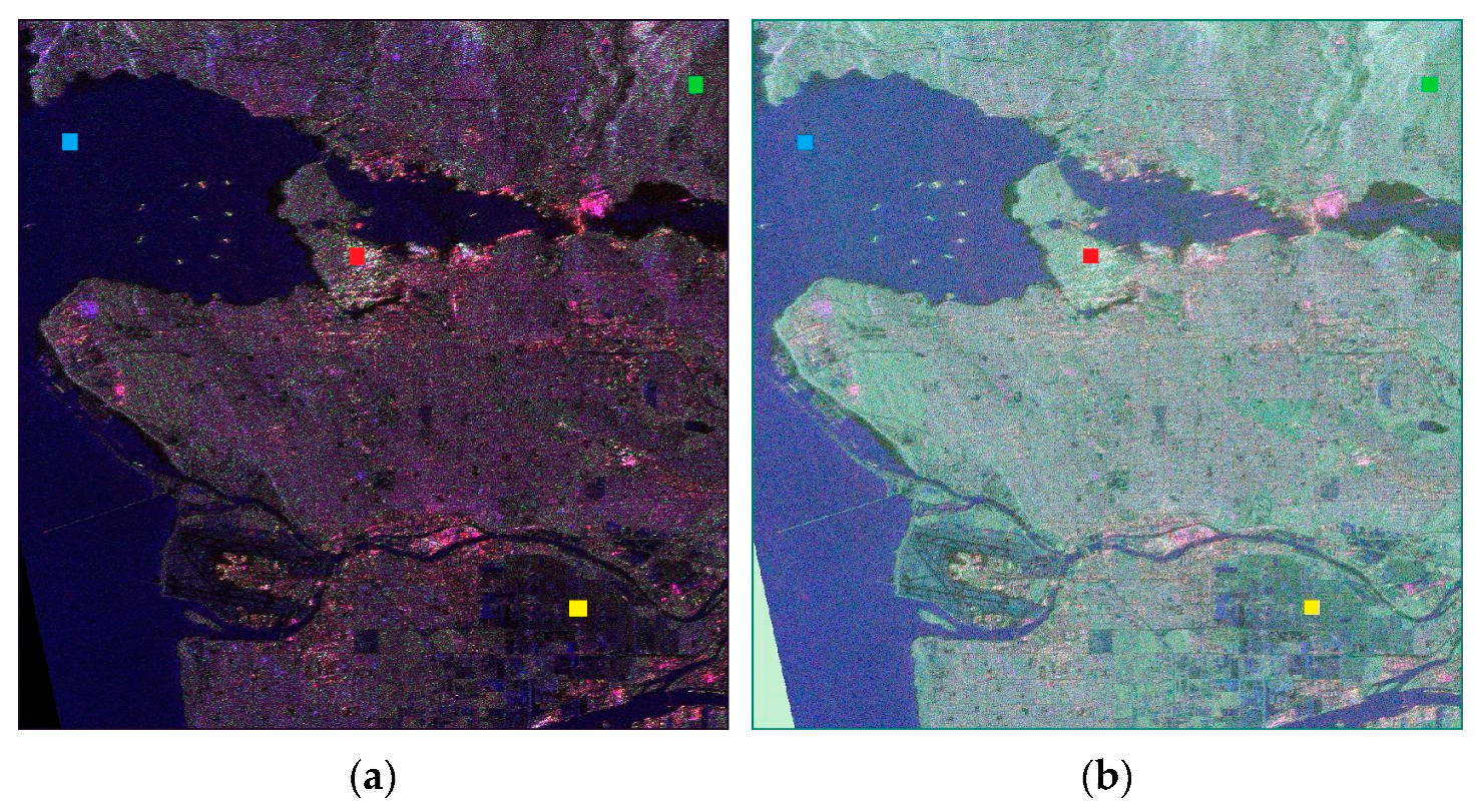
2. Study Area and Materials
3. Preprocessing: Fully PolSAR
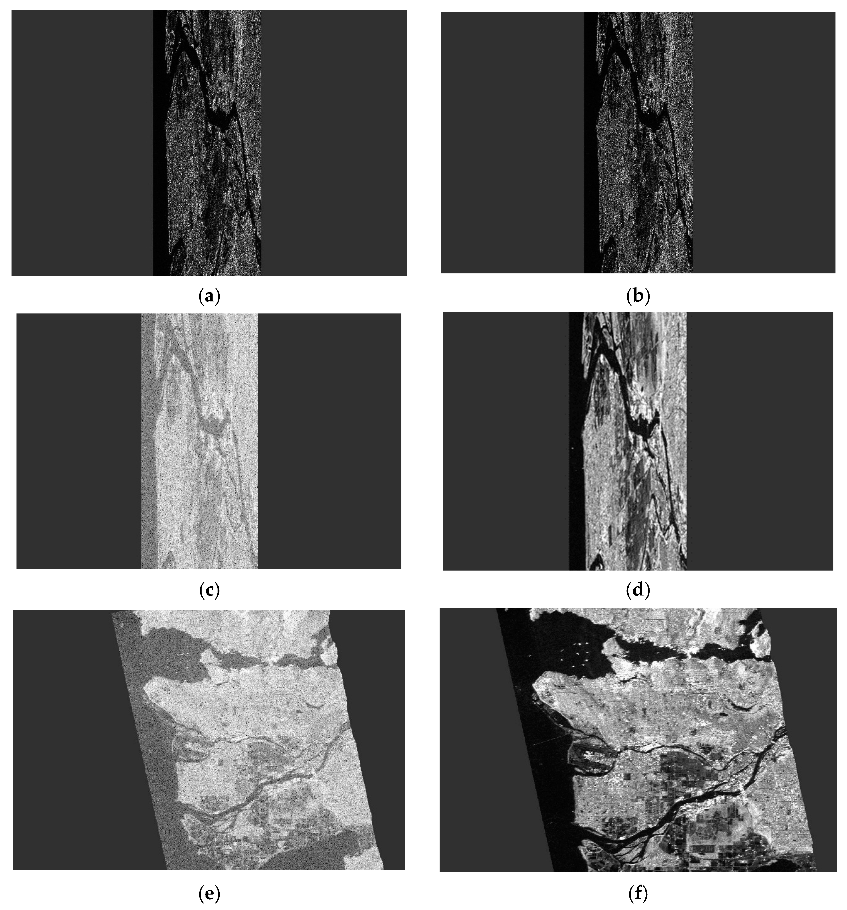
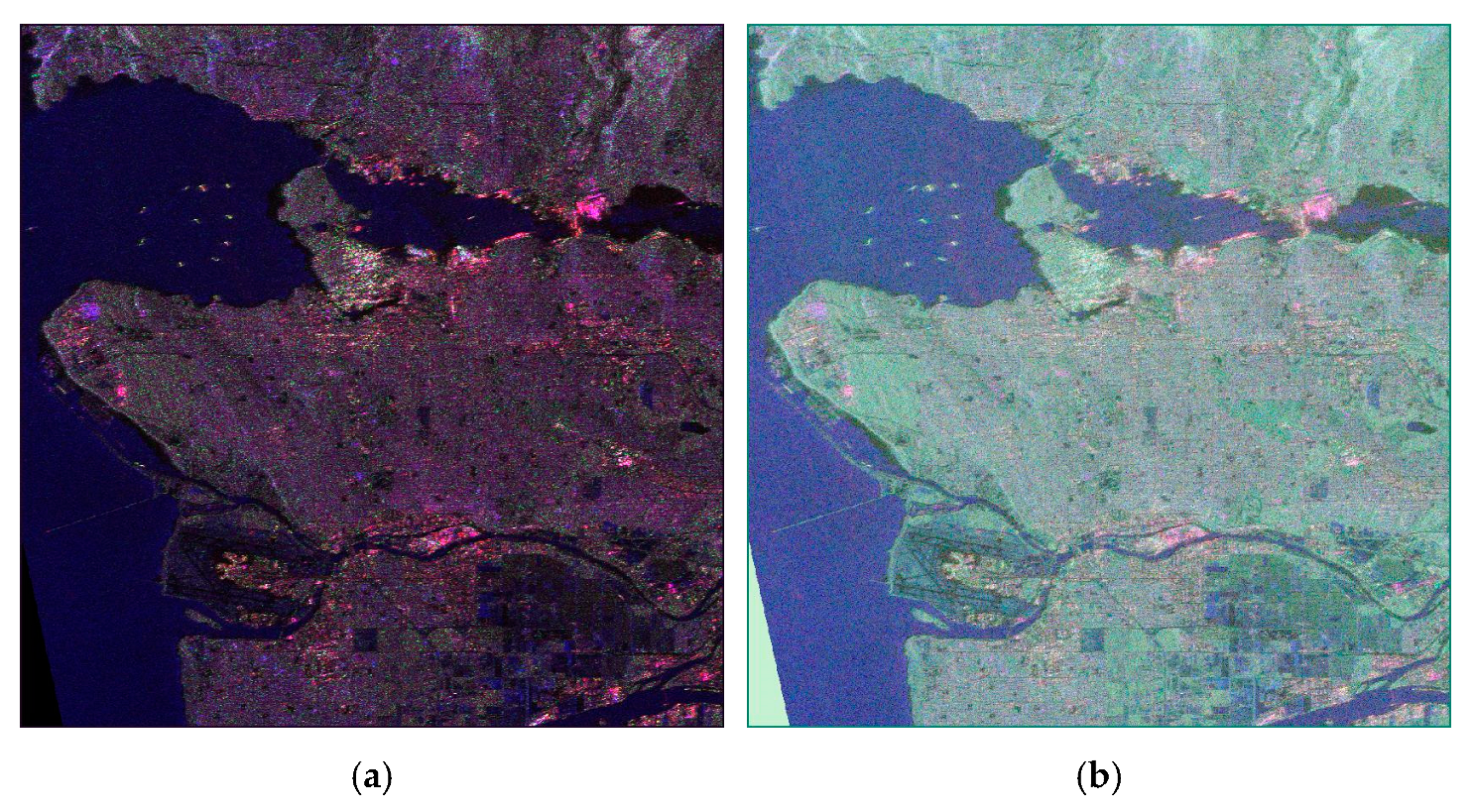
3.1. Pauli’s Decomposition
3.2. Pauli Color-Coded Representation
3.3. Krogager’s Decomposition
4. Feature Extraction: LPD
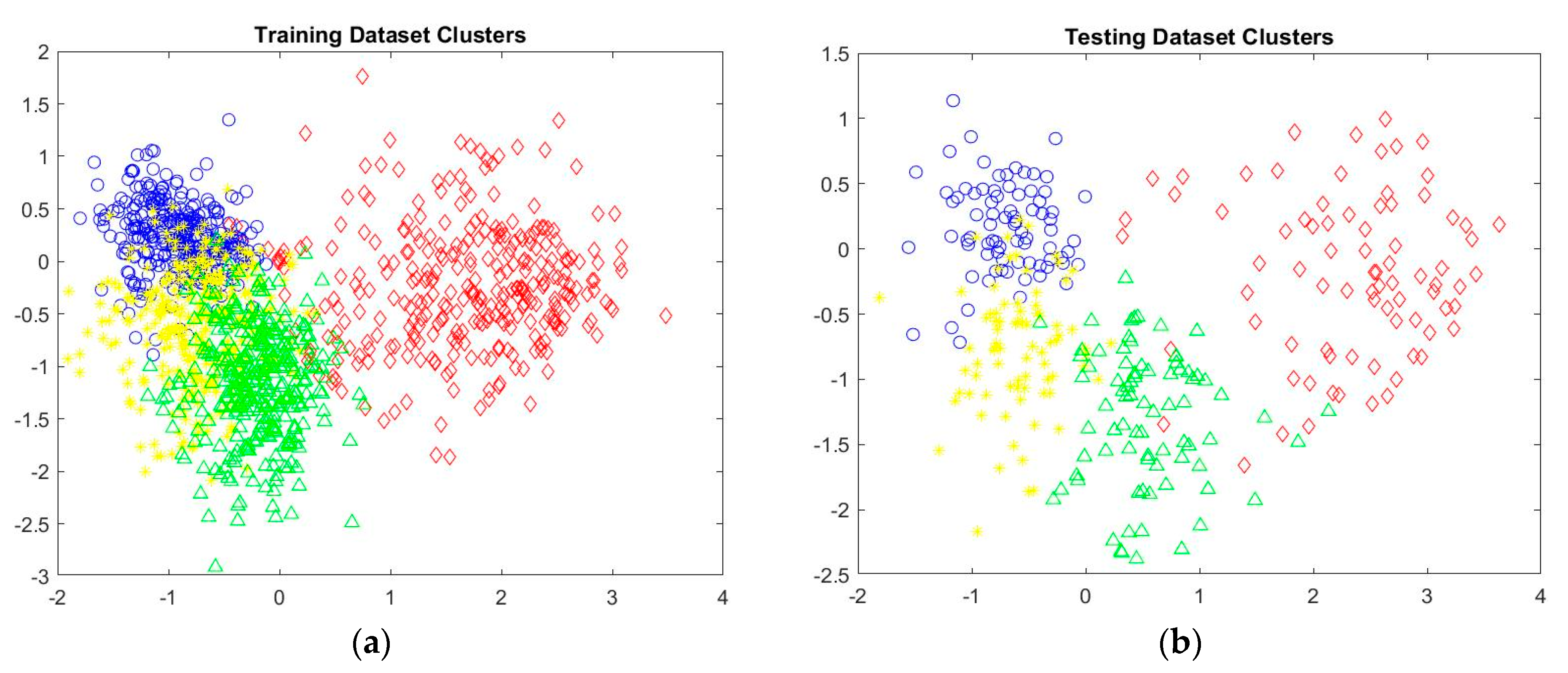
5. Classification: Experimental Results
6. Decision Fusion: Experimental Results
7. Discussion: Conclusions
7.1. Discussion
7.2. Conclusions
Author Contributions
Funding
Data Availability Statement
Conflicts of Interest
References
- González-Santiago, J.; Schenkel, F.; Gross, W.; Middelmann, W. Deep Self-Supervised Hyperspectral-Lidar Fusion for Land Cover Classification. In Proceedings of the IGARSS 2023—2023 IEEE International Geoscience and Remote Sensing Symposium, Pasadena, CA, USA, 16–21 July 2023. [Google Scholar] [CrossRef]
- Tu, B.; Ren, Q.; Li, Q.; He, W.; He, W. Hyperspectral Image Classification Using a Superpixel–Pixel–Subpixel Multilevel Network. IEEE Trans. Instrum. Meas. 2023, 72, 5013616. [Google Scholar] [CrossRef]
- Arpitha, M.; Ahmed, S.A.; Harishnaika, N. Land Use and Land Cover Classification Using Machine Learning Algorithms in Google Earth Engine. Earth Sci. Inform. 2023, 16, 3057–3073. [Google Scholar] [CrossRef]
- Liu, S.; Wang, H.; Hu, Y.; Zhang, M.; Zhu, Y.; Wang, Z.; Li, D.; Yang, M.; Wang, F. Land Use and Land Cover Mapping in China Using Multimodal Fine-Grained Dual Network. IEEE Trans. Geosci. Remote Sens. 2023, 61, 4405219. [Google Scholar] [CrossRef]
- Hua, W.; Wang, Y.; Yang, S.; Jin, X. PolSAR Image Classification Based on Multi-Modal Contrastive Fully Convolutional Network. Remote Sens. 2024, 16, 296. [Google Scholar] [CrossRef]
- Lv, Z.; Zhang, P.; Sun, W.; Benediktsson, J.A.; Lei, T. Novel Land-Cover Classification Approach with Nonparametric Sample Augmentation for Hyperspectral Remote-Sensing Images. IEEE Trans. Geosci. Remote Sens. 2023, 61, 1–13. [Google Scholar] [CrossRef]
- Quan, Y.; Zhang, R.; Li, J.; Ji, S.; Guo, H.; Yu, A. Learning SAR-Optical Cross Modal Features for Land Cover Classification. Remote Sens. 2024, 16, 431. [Google Scholar] [CrossRef]
- Chen, Y.; He, X.; Xu, J.; Guo, L.; Lu, Y.; Zhang, R. Decision Tree-Based Classification in Coastal Area Integrating Polarimetric SAR and Optical Data. Data Technol. Appl. 2021, 56, 342–357. [Google Scholar] [CrossRef]
- Bui, D.H.; Mucsi, L. Comparison of Layer-Stacking and Dempster-Shafer Theory-Based Methods Using Sentinel-1 and Sentinel-2 Data Fusion in Urban Land Cover Mapping. Geo-Spat. Inf. Sci. 2022, 25, 1–14. [Google Scholar] [CrossRef]
- Jin, Y.; Guan, X.; Ge, Y.; Jia, Y.; Li, W. Improved Spatiotemporal Information Fusion Approach Based on Bayesian Decision Theory for Land Cover Classification. Remote Sens. 2022, 14, 6003. [Google Scholar] [CrossRef]
- Maggiolo, L.; Solarna, D.; Moser, G.; Serpico, S.B. Optical-Sar Decision Fusion with Markov Random Fields for High-Resolution Large-Scale Land Cover Mapping. In Proceedings of the IGARSS 2022—2022 IEEE International Geoscience and Remote Sensing Symposium, Kuala Lumpur, Malaysia, 17–22 July 2022; pp. 5508–5511. [Google Scholar] [CrossRef]
- Zhu, J.; Pan, J.; Jiang, W.; Yue, X.; Yin, P. SAR Image Fusion Classification Based on the Decision-Level Combination of Multi-Band Information. Remote Sens. 2022, 14, 2243. [Google Scholar] [CrossRef]
- Papadopoulos, S.; Koukiou, G. Vassilis Anastassopoulos Correlated Decision Fusion Accompanied with Quality Information on a Multi-Band Pixel Basis for Land Cover Classification. J. Imaging 2024, 10, 91. [Google Scholar] [CrossRef]
- Chen, S.; Useya, J.; Mugiyo, H. Decision-Level Fusion of Sentinel-1 SAR and Landsat 8 OLI Texture Features for Crop Discrimination and Classification: Case of Masvingo, Zimbabwe. Heliyon 2020, 6, e05358. [Google Scholar] [CrossRef] [PubMed]
- Koukiou, G.; Anastassopoulos, V. Drunk person identification using local difference patterns. In Proceedings of the 2016 IEEE International Conference on Imaging Systems and Techniques (IST), Chania, Greece, 4–6 October 2016; pp. 401–405. [Google Scholar] [CrossRef]
- Koukiou, G.; Anastassopoulos, V. Local difference patterns for drunk person identification. Multimed. Tools Appl. 2018, 77, 9293–9305. [Google Scholar] [CrossRef]
- Tassiopoulou, S.; Koukiou, G. Fusing Ground-Penetrating Radar Images for Improving Image Characteristics Fidelity. Appl. Sci. 2024, 14, 6808. [Google Scholar] [CrossRef]
- Cloude, S.R.; Pottier, E. A Review of Target Decomposition Theorems in Radar Polarimetry. IEEE Trans. Geosci. Remote Sens. 1996, 34, 498–518. [Google Scholar] [CrossRef]
- Chen, S.-W.; Li, Y.; Wang, X.; Xiao, S.; Sato, M. Modeling and Interpretation of Scattering Mechanisms in Polarimetric Synthetic Aperture Radar: Advances and Perspectives. IEEE Signal Process. Mag. 2014, 31, 79–89. [Google Scholar] [CrossRef]
- Sun, X.; Song, H.; Wang, R.; Li, N. High-Resolution Polarimetric SAR Image Decomposition of Urban Areas Based on a POA Correction Method. Remote Sens. Lett. 2018, 9, 363–372. [Google Scholar] [CrossRef]
- Zhang, Y.; Wu, L.; Geng, W. A New Classifier for Polarimetric SAR Images. Prog. Electromagn. Res. 2009, 94, 83–104. [Google Scholar] [CrossRef]
- Gaglione, D.; Clemente, C.; Pallotta, L.; Proudler, I.; De Maio, A.; Soraghan, J.J. Krogager Decomposition and Pseudo-Zernike Moments for Polarimetric Distributed ATR. In Proceedings of the 2014 Sensor Signal Processing for Defence (SSPD), Edinburgh, UK, 8–9 September 2014. [Google Scholar] [CrossRef]
- Milan, J.M. Book Review [Review of “Principles of Modern Radar-Basic Principles (Richards, M.A., Eds, et Al; 2010)]. IEEE Aerosp. Electron. Syst. Mag. 2013, 28, 40–42. [Google Scholar] [CrossRef]
- Hellmann, M.; Krogager, E. Comparison of Decompositions for Pol-SAR Image Interpretation. Int. Geosci. Remote Sens. Symp. 2002, 3, 1313–1315. [Google Scholar] [CrossRef]
- Alberga, V.; Krogager, E.; Chandra, M.; Wanielik, G. Potential of Coherent Decompositions in SAR Polarimetry and Interferometry. In Proceedings of the IGARSS’04. 2004 IEEE International Geoscience and Remote Sensing Symposium, Anchorage, AK, USA, 20–24 September 2004; Volume 3. [Google Scholar] [CrossRef]
- Wei, Q.; Chen, J.-j.; Zhao, H.-z.; Feng, Z. Target Decomposition for Fully Polarimetric Wideband Radar System. In Proceedings of the IEEE 10th International Conference on Signal Processing Proceedings (ICSP), Beijing, China, 24–28 October 2010. [Google Scholar] [CrossRef]
- Zhang, L.; Zhang, J.; Zou, B.; Zhang, Y. Comparison of Methods for Target Detection and Applications Using Polarimetric SAR Image. Piers Online 2008, 4, 140–145. [Google Scholar]
- Kumar, D. Urban Objects Detection from C-Band Synthetic Aperture Radar (SAR) Satellite Images through Simulating Filter Properties. Sci. Rep. 2021, 11, 6241. [Google Scholar] [CrossRef] [PubMed]
- Jiang, W.; Yu, A.; Dong, Z.; Wang, Q. Comparison and Analysis of Geometric Correction Models of Spaceborne SAR. Sensors 2016, 16, 973. [Google Scholar] [CrossRef]
- Makineci, H.B.; Karabörk, H. Evaluation Digital Elevation Model Generated by Synthetic Aperture Radar Data. ISPRS 2016, XLI-B1, 57–62. [Google Scholar] [CrossRef]
- Guan, D.-d.; Tang, T.; Li, Y.; Lu, J. Local Pattern Descriptor for SAR Image Classification. In Proceedings of the IEEE 5th Asia-Pacific Conference on Synthetic Aperture Radar (APSAR), Singapore, 1–4 September 2015. [Google Scholar] [CrossRef]
- Rajesh, K.; Jawahar, C.V.; Sengupta, S.; Sinha, S. Performance Analysis of Textural Features for Characterization and Classification of SAR Images. Int. J. Remote Sens. (Print) 2001, 22, 1555–1569. [Google Scholar] [CrossRef]
- Ojala, T.; Pietikainen, M.; Maenpaa, T. Multiresolution Gray-Scale and Rotation Invariant Texture Classification with Local Binary Patterns. IEEE Trans. Pattern Anal. Mach. Intell. 2002, 24, 971–987. [Google Scholar] [CrossRef]
- Tan, X.; Triggs, B. Enhanced Local Texture Feature Sets for Face Recognition under Difficult Lighting Conditions. IEEE Trans. Image Process. 2010, 19, 1635–1650. [Google Scholar] [CrossRef]
- Lee, J.-S. Digital Image Enhancement and Noise Filtering by Use of Local Statistics. IEEE Trans. Pattern Anal. Mach. Intell. 1980, PAMI-2, 165–168. [Google Scholar] [CrossRef] [PubMed]
- Dai, D.; Yang, W.; Sun, H. Multilevel Local Pattern Histogram for SAR Image Classification. IEEE Geosci. Remote Sens. Lett. 2011, 8, 225–229. [Google Scholar] [CrossRef]
- Popescu, M.C.; E Balas, V.; Perescu-Popescu, L.; Mastorakis, N. Multilayer Perceptron and Neural Networks. WSEAS Trans. Circuits Syst. 2009, 8, 579–588. [Google Scholar]
- Pal, M. Random Forest Classifier for Remote Sensing Classification. Int. J. Remote Sens. 2005, 26, 217–222. [Google Scholar] [CrossRef]
- Safavian, S.R.; Landgrebe, D. A Survey of Decision Tree Classifier Methodology. IEEE Trans. Syst. Man. Cybern. 1991, 21, 660–674. [Google Scholar] [CrossRef]
- Duda, R.O.; Hart, P.E.; Stork, D.G. Pattern Classification; John Wiley & Sons: Hoboken, NJ, USA, 2012; pp. 90–91. ISBN 9781118586006. [Google Scholar]
- Kuncheva, L.I. Combining Pattern Classifiers; John Wiley & Sons: Hoboken, NJ, USA, 2004; pp. 126–127. ISBN 9780471660255. [Google Scholar]
- Koukiou, G. Short Words for Writer Identification Using Neural Networks. Appl. Sci. 2023, 13, 6841. [Google Scholar] [CrossRef]


| Pauli Basis | Meaning |
|---|---|
| Single- or odd-bounce scattering: this occurs when a radar signal interacts with a target and undergoes a single reflection or bounce before reaching the radar sensor. | |
| Double- or even-bounce scattering: This can happen, for instance, when radar waves hit a surface, reflect off, and then reflect again off another surface before returning to the sensor. | |
| Volume scattering: This type of scattering is more complex and involves multiple interactions within the target volume, leading to a scattering signal that does not follow a simple direct path (forest canopy). |
| Class | Number Assigned | Training Pixels | Testing Pixels |
|---|---|---|---|
| Urban | 0 | 320 | 80 |
| Sea | 1 | 320 | 80 |
| Crop | 2 | 320 | 80 |
| Forest | 3 | 320 | 80 |
| Class | 0 | 1 | 2 | 3 | Total | |
|---|---|---|---|---|---|---|
| True Class | 0 | 71 | 2 | 1 | 6 | 80 |
| 1 | 2 | 61 | 17 | 0 | 80 | |
| 2 | 0 | 16 | 46 | 18 | 80 | |
| 3 | 13 | 1 | 11 | 55 | 80 | |
| Total | 86 | 80 | 75 | 79 | ||
| Predicted Class | ||||||
| Class | 0 | 1 | 2 | 3 | Total | |
|---|---|---|---|---|---|---|
| True Class | 0 | 74 | 1 | 1 | 4 | 80 |
| 1 | 5 | 62 | 11 | 2 | 80 | |
| 2 | 1 | 13 | 51 | 15 | 80 | |
| 3 | 5 | 1 | 8 | 66 | 80 | |
| Total | 85 | 77 | 71 | 87 | ||
| Predicted Class | ||||||
| Class | 0 | 1 | 2 | 3 | Total | |
|---|---|---|---|---|---|---|
| True Class | 0 | 69 | 1 | 1 | 9 | 80 |
| 1 | 0 | 76 | 4 | 0 | 80 | |
| 2 | 0 | 8 | 65 | 7 | 80 | |
| 3 | 10 | 0 | 5 | 65 | 80 | |
| Total | 79 | 85 | 75 | 81 | ||
| Predicted Class | ||||||
| Classifier | Class | Overall Accuracy | ||||
|---|---|---|---|---|---|---|
| Urban | Sea | Crop | Forest | |||
| Decision Tree | Accuracy (%) | 88.8 | 76.3 | 57.5 | 68.8 | 72.9 |
| Neural Network | 92.5 | 77.5 | 63.8 | 82.5 | 79.1 | |
| Random Forest | 86.3 | 95 | 81.2 | 81.2 | 85.9 | |
| Class | |||||
|---|---|---|---|---|---|
| Urban | Sea | Crop | Forest | Overall Accuracy | |
| Accuracy (%) | 99.7 | 99.2 | 94.9 | 98.5 | 98.1 |
| Study/Author | Data Sources/Inputs | Methodology | Classifiers Used | Evaluation Metrics | Classification Results |
|---|---|---|---|---|---|
| Jin et al. [10] | Multi-source satellite images (high spatial and temporal resolution) MODIS, LANDSAT | Spatiotemporal information fusion using Bayesian Decision Theory to integrate spatial and temporal data. Preprocessing involved aligning multi-source images spatially and temporally. | Support Vector Machine (SVM) (for LANDSAT) ED-similarity (for MODIS) and PBF | Class-wise and Overall Accuracy (OA) | PBF Class-wise Accuracy: Construction Land: 96% Crop1: 96% Crop2: 64% Gobi: 86% Grassland: 43% Slope Field: 57% Wasteland: 42% Water: 96% OA: 75% |
| Our study | PolSAR data Local Pattern Descriptor (LPD) for local structure analysis of the decomposition components. | Quantization of image bands using contrast technique; Local structure capture with LPD; Bayesian Decision Fusion combining Decision Tree (DT), Neural Network (NN), and Random Forest (RF) classifiers | Decision Tree, Neural Network, Random Forest (with Bayesian fusion) | OA, Class-wise accuracies, Posterior probabilities (after Bayesian fusion) | Pre-fusion: DT: 72.9% NN: 79.1% RF: 85.9% After fusion: OA: 98.1% |
Disclaimer/Publisher’s Note: The statements, opinions and data contained in all publications are solely those of the individual author(s) and contributor(s) and not of MDPI and/or the editor(s). MDPI and/or the editor(s) disclaim responsibility for any injury to people or property resulting from any ideas, methods, instructions or products referred to in the content. |
© 2024 by the authors. Licensee MDPI, Basel, Switzerland. This article is an open access article distributed under the terms and conditions of the Creative Commons Attribution (CC BY) license (https://creativecommons.org/licenses/by/4.0/).
Share and Cite
Papadopoulos, S.; Anastassopoulos, V.; Koukiou, G. Pixel-Level Decision Fusion for Land Cover Classification Using PolSAR Data and Local Pattern Differences. Electronics 2024, 13, 3846. https://doi.org/10.3390/electronics13193846
Papadopoulos S, Anastassopoulos V, Koukiou G. Pixel-Level Decision Fusion for Land Cover Classification Using PolSAR Data and Local Pattern Differences. Electronics. 2024; 13(19):3846. https://doi.org/10.3390/electronics13193846
Chicago/Turabian StylePapadopoulos, Spiros, Vassilis Anastassopoulos, and Georgia Koukiou. 2024. "Pixel-Level Decision Fusion for Land Cover Classification Using PolSAR Data and Local Pattern Differences" Electronics 13, no. 19: 3846. https://doi.org/10.3390/electronics13193846
APA StylePapadopoulos, S., Anastassopoulos, V., & Koukiou, G. (2024). Pixel-Level Decision Fusion for Land Cover Classification Using PolSAR Data and Local Pattern Differences. Electronics, 13(19), 3846. https://doi.org/10.3390/electronics13193846