Article

Assessing Impacts of New Subway Stations on Urban Thefts in the Surrounding Areas

1
Center of Geo-Informatics for Public Security, School of Geography and Remote Sensing, Guangzhou University, Guangzhou 510006, China
2
Department of Geography, University of Cincinnati, Cincinnati, OH 45221, USA
3
Department of Justice Sciences, The University of Findlay, Findlay, OH 45840, USA
*
Author to whom correspondence should be addressed.
ISPRS Int. J. Geo-Inf. 2021, 10(10), 632; https://doi.org/10.3390/ijgi10100632
Submission received: 6 July 2021 / Revised: 10 September 2021 / Accepted: 12 September 2021 / Published: 23 September 2021

Abstract

:
Whether newly implemented public transit stations influence the nearby crime pattern has been debated for years. In ZG City, China, 2 new subway lines and 20 new stations were implemented in 2017. This intervention allows us to test the plausible relationship between new public transit stations and thefts in the surrounding areas. We use the difference-in-differences (DID) model to assess the theft in the treatment and control areas before and after the implementation of the new stations, with necessary socioeconomic and land-use variables and time from the addition of the station being controlled. We also explicitly examine the impacts of the proximity of the stations and the Spring Festival on theft. The results suggest the following: (1) theft around the new subway stations significantly increases after the stations’ implementation, while the control area does not see much change in thefts; (2) proximity between the neighboring stations’ increases thefts; and (3) theft near the new stations significantly decreases during the month of the Spring Festival. This study contributes to the literature on the relationship between the subway system and crime, especially from a Chinese perspective. The finding of the research can bring insights to urban transit planning, allocation of the police force, and crime prevention.

1. Introduction

Public transit systems’ construction and development can change a city’s spatial structure. The spatial structure of the city influences citizens’ routine activities, which are closely related to crime opportunities [1]. Thus, public transit systems are expected to be closely related to crime patterns in the city [2]. Abundant studies have suggested that crime tends to cluster in and around the public transit system, rather than the places far away [3,4,5,6,7,8,9]. There are two possible reasons for this: (1) people waiting at the transit stations may become potential targets/victims [10], and (2) motivated offenders may use public transit as their commuting method and rely on the large population nearby for concealment [11,12]. Many studies have suggested a significant relationship between public transit and crime in both small cities with bus transit systems [13,14] and large cities with complex transit systems that may consist of buses, light rails, and subways [15,16,17] in many countries.
Most previous studies mainly focus on the relationship between bus transit stops and crime. Gaziarifoglu et al. analyzed 1371 robberies in Newark, NJ, and found that the spatial distributions of robberies and bus stops were highly correlated [18]. Other studies on this topic also suggested that street robberies tend to concentrate around bus stops [6,16,19,20]. Stucky and Smith used 500 × 500 square feet grid cells to assess the relationship between bus stops and various crime types (rape, robbery, aggravated assault, burglary, and larceny). The results of the negative binomial models suggest a statistically significant relationship, with socioeconomic and land-use conditions being controlled [21]. Gerell verified such a relationship by using negative binomial models and 200 m buffers around bus stops in Malmö, Sweden [22]. Liu et al. went a step further and found that the addition and removal of bus stops influenced nearby street robbery incidents. They applied difference-in-differences (DID) models to test the influences of time from bus stops’ addition/removal on street robberies, with necessary socioeconomic and land-use conditions being controlled [14]. In summary, existing studies have provided sufficient evidence on the relationship between bus transit and crime, but the relationship between subway transit and crime has only received limited attention.
The intra-city railway transit system serves as one of the most sufficient methods to optimize the traffic pattern in many large cities. The implementation of the railway transit system promotes the green commute, which not only settles the cities’ traffic congestion problem, but also improves air quality. However, citizens’ concerns about crime may follow the expansion of railway transit. The construction of the railway transit may raise citizens’ fear of crime, especially property crimes, such as thefts [12,23]. The implementation of the railway transit system is likely to lead to the concentration of the population, which may increase crime opportunities [24,25]. This is because the newly established railway transit system will change the distribution of the nearby ambient population and their routine activities. Consequently, the coexistence of motivated offenders and suitable targets are more likely to happen around stations, which leads to a change in crime opportunities [26,27,28]. Rational choice theory tells us that motivated offenders will weigh the needed efforts against potential gain before committing a criminal act. Motivated offenders usually have limited financial sources, and the development of railway transit can reduce their travel costs, allowing them to explore more places and more opportunities in and around the railway transit [7,13,29]. Most offenders usually travel only 1.6–3.2 km to commit crime because a longer journey requires more time, money, and effort [30,31,32,33]. However, offenders are likely to recognize the convenience that the railway transit brings to them and take advantage of that to expand their radius of action with a minimal increase in transportation costs [7,13,29]. Some surveys have found that citizens living near the railway transit thought the traffic congestion was eased, but they also expressed concerns about crime [23]. People living in suburban areas also complained that the railway transit bore issues, such as crime, gangs, and drugs [18,34]. On the contrary, one study in Atlanta, GA, found that crime increased downtown but decreased in suburban areas after implementation of the railway transit system [35]. This may be because the development of the railway transit system promotes the convergence of more people from downtown, including potential offenders and targets [2,15,36]. People who routinely visit the railway stations may become the new potential targets for motivated offenders who were familiars with the place [2,11,37]. These transit stations and the surrounding areas may attract large amounts of commuting people and become crime generators [38,39,40]. This has been confirmed by multiple studies [26,41,42].
However, whether railway stations will inevitably result in more crime is debatable. Block and Block found that alcohol-related crime was significantly related to the expansion of the railway system in the city of Bronx and Chicago [11]. Phillips and Sandler found that crime was decreased in Washington, DC, in the metropolitan area when the railway system was shut down [43]. Christopher and Andrew et al. also found robbery frequency during temporary subway station closures, with larger reductions occurring in closer proximities to the subway station in New York [44]. Estévez-Soto found some crime categories to be declined in association with the reductions seen in public transport passenger numbers due to the COVID-19 pandemic in Mexico City [45]. On the contrary, Deangelo et al. found crime to be increased during the public transit systems’ (including railway and bus) strike in Los Angeles, CA [46]. Billings and colleagues used the DID method and a quasi-experimental design to study crime and the light rail transit system in the city of Charlotte and found that crime did not increase because of the construction or implementation of the light rail [47]. Ihlanfeldt’s study in Atlanta, GA, argued that crime near the transit stations changed because of the socioeconomic factors’ drastic change after the implantation of the railway system, not the usage of railway stations [35]. Sedelmaier studied the relationship between expansion transit stations and crime for several years, and he found it not necessarily to have a criminogenic effect on the neighbor-hoods served [48,49]. In summary, studies in different cities with different data and methods did not yield consistent results. In particular, we do not have sufficient evidence on the impact of new stations on crime; to determine whether they are likely to increase/reduce crime, additional tests are necessary. Moreover, the existing studies mainly focused on the western population, but the Chinese case has rarely received attention. This study aims to fill this gap.
People tend to have different travel patterns on holidays, especially in cities [50], and such changes may influence the crime pattern. Cohn and Rotton found that general holidays do not alter the crime pattern, but important ones tend to witness more violent crime incidents, with fewer property crime incidents [51]. In addition, Vania Ceccato found that stations’ environmental attributes affect crime at different times [52]. Ridership of the subway in ZG City can be different on holidays too, especially during major holidays, such as the Spring Festival, so we include the holiday factor in the analysis.
China is experiencing rapid modernization and urbanization, and the urban population is drastically increasing. Subway transit systems have become the major commuting method for many citizens in many large cities in China. By the end of 2018, 36 cities in China implemented subway transit systems, and the total length of the lines exceeded 5494.9 km [53]. ZG City ranks near the top in terms of subway transit systems in the nation. We focus on thefts in this study because, among all crime types, theft is usually the most frequent one and is closely related to people’s routine activities [41]. Theft has received special attention from Chinese criminology scholars because it seriously influences people’s property security in our routine lives [54,55]. In this study, we will assess the plausible relationship between theft and new subway stations in a large Chinese city. In particular, we will use DID models to test whether the newly implemented subway stations result in more thefts in the nearby areas, with necessary socioeconomic, land-use, and holiday factors being controlled.

2. Study Area and Methodology

2.1. Study Area

ZG City is an international, large city, located in southern China. It is large in both size and population: the total area of the city is 7434 km2, and the population was 15 million in 2018. ZG City is composed of 7 old districts and 4 new districts (YP, DH, CZ, and HC). The rapid development in the economy generates more working opportunities and attracts more people to this city. To accommodate the large population’s commuting demands, ZG City established and continually advances public transit systems, especially the subway system. By the end of 2020, there were 16 subway lines in ZG City with a total length of 553.2 km [56]. Subway platforms are almost exclusively underground. Unlike the light rail stations, subway entrances do not take up much space on the ground. Thus, many commercial activities happen around subway entrances. As Chen and colleagues (2015) stated, various facilities, such as restaurants, supermarkets, shopping malls, etc., are located at or adjacent to both regular and interchange subway stations [57]. These facilities serve subway passengers and nearby residents (Figure 1a). Additionally, small retail shops, laundromats, and ATMs exist inside the underground subway stations [58]. Passengers can use cash, credit/debit cards, and digital wallets for transactions at these underground stores (Figure 1b).
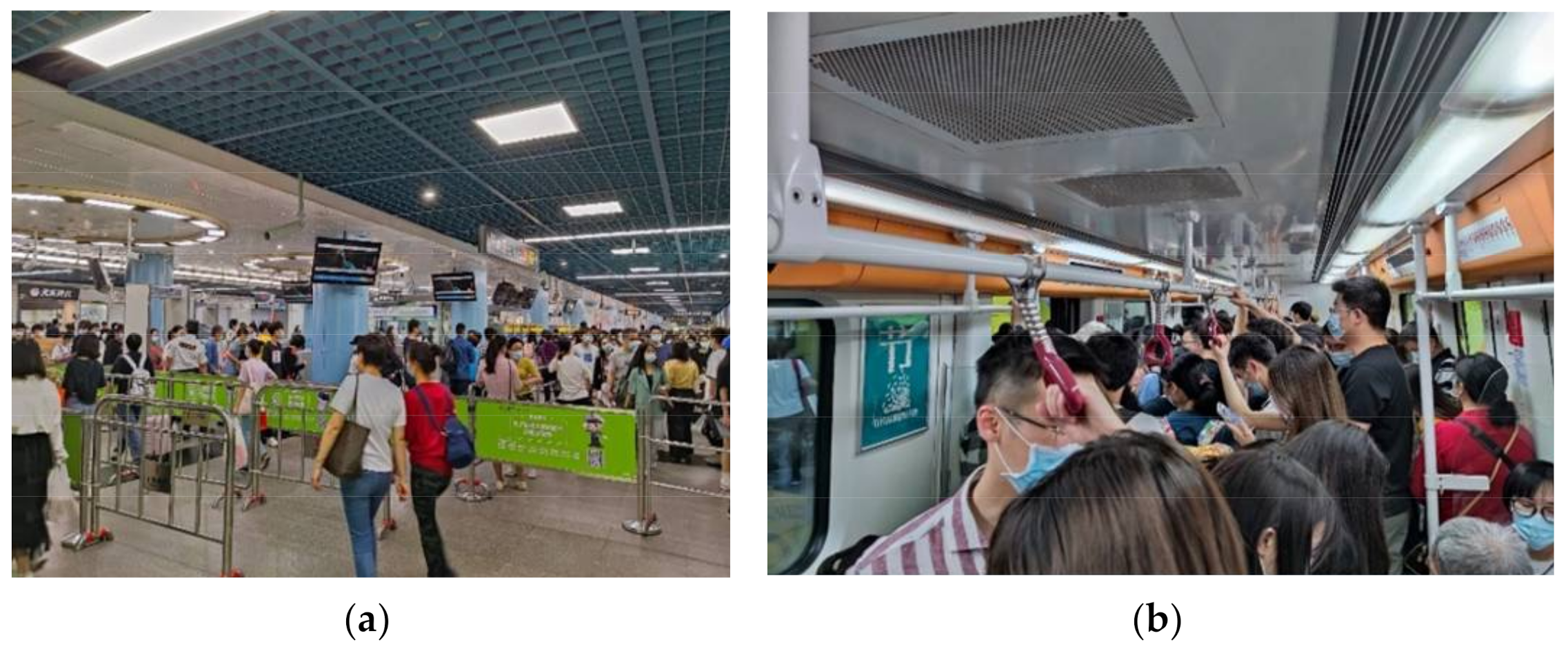
Increased coverage of the ZG subway facilitates urban expansion. Many people take advantage of the affordable housing in the suburbs and commute to work at the city center via the subway system. The low fare, high frequency, and convenient transfer of the subway make it the main public transportation tool for citizens. During the rush hours, key transfer stations are flooded with passengers (Figure 2a). Even during non-rush hours, stations are still crowded with passengers (Figure 2b).
The subway system of ZG City is solely invested and managed by the local government. Therefore, accessibility, equality, and social justice, rather than the return of investment, are considered the priorities when the subway transit is planned and constructed [59]. Consequently, subway systems in Chinese cities, such as ZG City, link not only populated and wealthy areas, such as the downtown area, but also less populated and non-wealthy suburban areas. For the sake of promoting local economy and accessibility, the ZG City government added 2 new subway lines (Line 9 and Line 13) to link new districts, including CZ, YP, and DH.
As shown in Table 1, both Line 9 and Line 13 started to operate on 28 December 2017. Line 9 has 11 stations, and the total length is 20.1 km. It is interchangeable with Line 3 and Line 8 at one station. The daily ridership of Line 9 was 106.7 thousand in 2018 [60,61]. Line 13 has 11 stations, and the total length is 27.03 km. It is interchangeable with Line 5 at one station and will be interchangeable with Line 7 and Line 16 in the future. The daily ridership of Line 13 was 110.5 thousand in 2018 [60,61].

2.2. Research Questions and Methodology

2.2.1. Research Questions

This study aims to answer three questions: (1) Will the new subway stations influence the nearby theft patterns? (2) Will proximity between the neighboring stations increase thefts? (3) Will the relationship between theft and subway stations change during the Spring Festival, when most people’s routines change? Our hypotheses are as follows: (1) The implementation of new subway stations may attract people and create more crime opportunities, so thefts around new stations may increase. The infrastructure around new subway stations would attract a large number of passengers/people. Crowds gather at and around the station, as passengers line up to enter the station, buy goods, recharge transit cards and wait for their friends or family. It provides an opportunity for the occurrence of crime. (2) When stations are located closer to each other, thefts may increase. The closer stations are to one another, the more conducive this is to the flow of crime. If two stations are very close to each other, offenders in a station who successfully commit theft are likely to continue to the next station, thus increasing crimes. (3) During the Spring Festival, ridership will decrease drastically, and consequently, crime opportunities and thefts shall decrease as well. ZG city is a large migrant city. Most of these migrants will go back to their hometown for the Spring Festival and return after the holiday. During the Spring Festival holiday, the residential population of ZG City decreases significantly. This may affect the subway passenger flow. After a sharp drop in traffic, criminals lose potential targets, and the proceeds of crime are lower than usual. The offender may choose to delay or abandon the idea of committing a crime.

2.2.2. Methodology

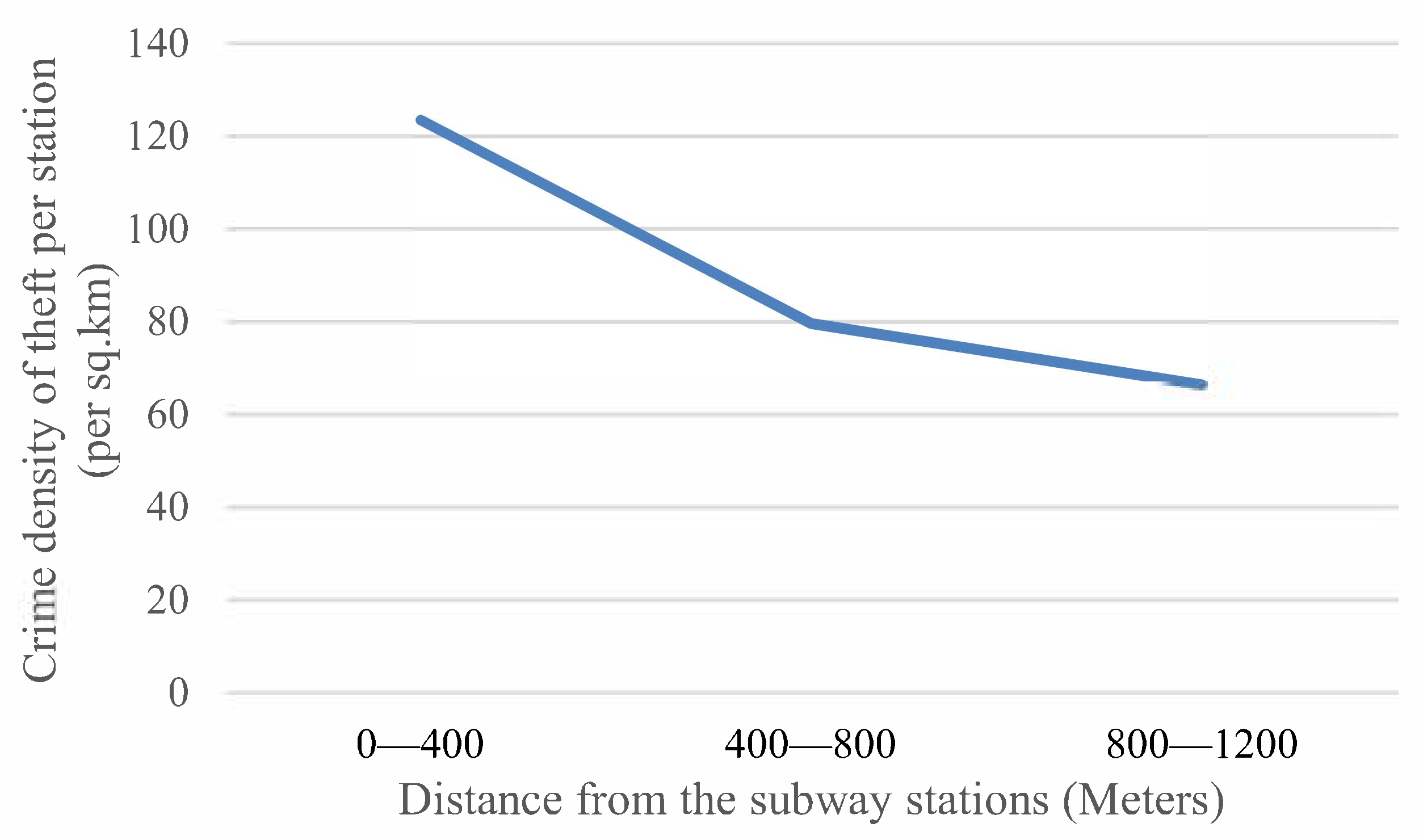
The difference-in-differences (DID) model was firstly used in economics to evaluate the effect of the policy [62]. This method was then used in various fields, including geography [63,64,65], planning [66], and crime [47,67]. We use DID to evaluate the differential effect of the implementation of subway stations on nearby thefts. DID and a quasi-experimental design can help induce the possible causal impact of an intervention on the subject [68,69,70]. Our quasi-experiment design considers these new subway stations’ nearby areas as the treatment area and areas along the subway route, but without subway stations, as the control area. The radius of the nearby area is decided based on the “a quarter-mile assumption”: most pedestrians are willing to walk, at most, a quarter mile (about 400 m) to take public transit [71,72,73,74]. To test the potential distance decay of theft patterns around the subway stations, we create multiple rings around stations from 400 m to 1200 m, with an interval of 400 m. Figure 3 shows a clear distance decay phenomenon of thefts around stations.
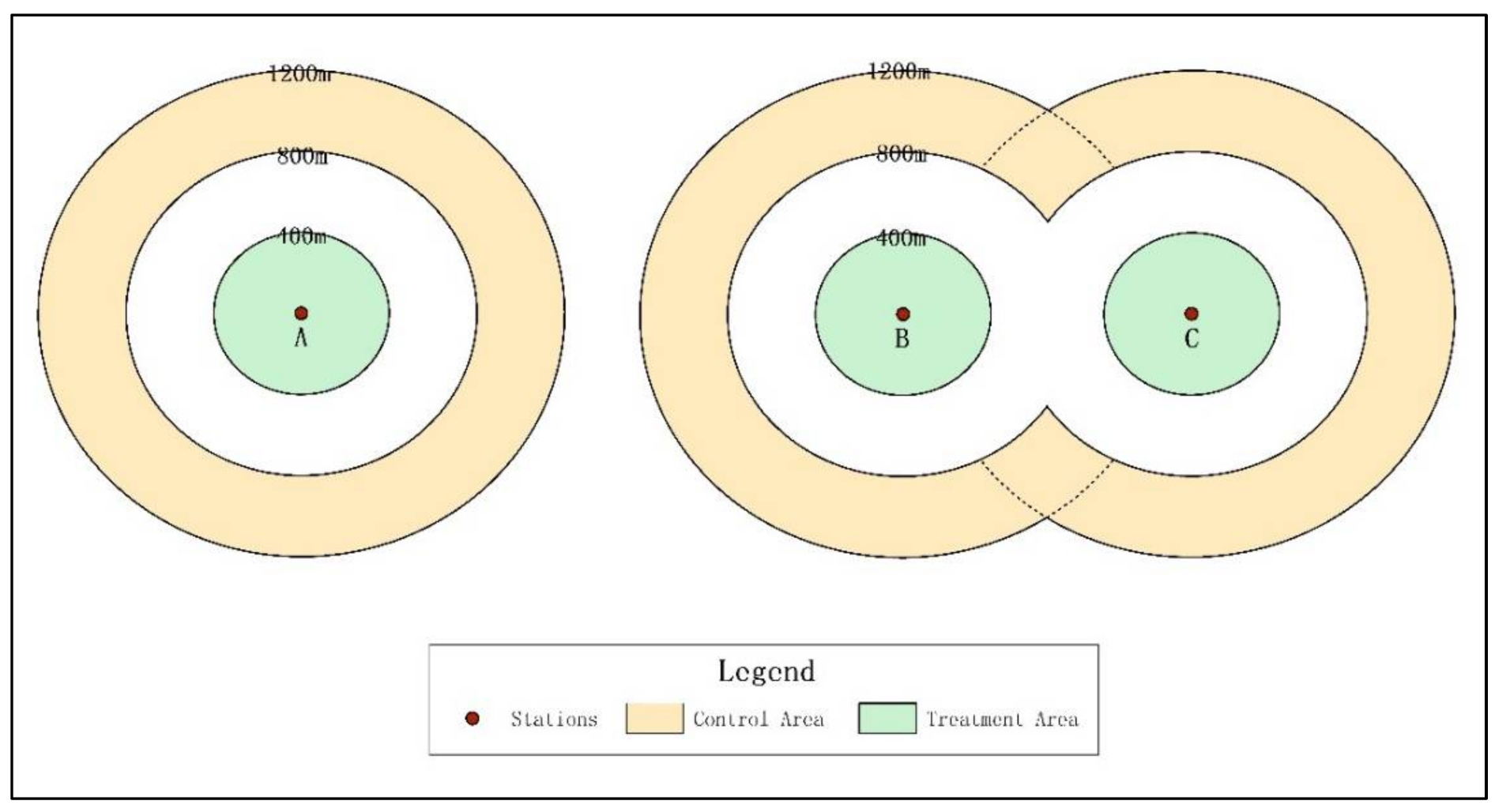
As shown in Figure 3, the thefts density is higher than 120/km2 within 400 m of the new subway stations. This number rapidly drops to less than 80/km2 in the range of 400–800 m and the trend continues from 800 m to 1200 m around stations. Following the literature [71,72,73,74], we select 400 m buffer around each new station as the treatment area. As it is the core area adjacent to the subway station, land-use change in this area is bound to be the strongest before and after the opening of the subway. There may be additional infrastructures that follow around the new station, such as supermarkets and pubs [75]. To account for the influence of crime displacement [76] or diffusion of benefits [77,78], we also create a 400–800 m ring around each station as the buffer area and a 800–1200 m ring as the control area. Each subway station only has one treatment area, one buffer area, and one control area. Since the distance between some neighboring stations is less than 1600 m (double 800 m), the buffer areas and control areas of these stations may overlap (Figure 4). In such cases, priority is given to the treatment area, followed by the buffer area and the control area, which is last. For example, if station B’s control area is overlapped with station C’s treatment area, the overlapped portion will be regarded as station C’s treatment area. If station B’s control area is overlapped with station C’s buffer area, the overlapped portion will be regarded as station C’s buffer area. If station B’s control area is overlapped with station C’s control area, the overlapped area will be regarded as the control area of both station B and station C.

3. Data

3.1. Subway Stations

We collect the information of subway stations for Line 9 and Line 13 from Gaode Map (also known as Amap). The information includes stations’ precise spatial locations, names, associated lines, etc. The point-of-interests (POI) data from Gaode Map were tested reliably by various studies in China [79,80,81]. We use ArcGIS 10.2 to perform all spatial analyses. It is necessary to mention that Line 9 has a pre-existing station that used to belong to other lines and is now shared by Line 9. A pre-existing station exists on Line 13 as well. These two stations are excluded from this study because they are not newly implemented. Consequently, the sample size of this study is 20 stations, 10 on Line 9 and 10 on Line 13. Line 9’s stations concentrate in the DH District, while Line 13’s stations are spread from the PH District to CZ District.

3.2. Dependent Variable

Theft is a major type of crime in the public security system. Roughly 90% of thefts are pocket-picking. The theft data used in this study are of thefts that occurred outside of the ticket gate of the subway station. The cases inside of the ticket gate and in the subway are reported to a special traffic-control department, and are not included in this study. We study thefts from 1 January 2017 to 31 December 2018. The beginning of the subway operation of Lines 9 and 13 was 28 December 2017, right in the middle of the two years, so we can compare the monthly changes of thefts before and after the operation of these two subway lines.
As the law of crime concentration indicates, criminal acts, including theft, are not randomly or evenly distributed. Rather, they are highly concentrated in spaces [82,83,84]. Consequently, the distributions of the theft or its density are not normal.
Because the DID model is a linear regression model, it requests the normal distribution of the dependent variable. To normalize the distribution of thefts, we use the natural logarithm of theft density as the dependent variable, following a previous study [85]. To avoid the logarithm of 0, we add 0.2 (half of the smallest non-zero number 0.4) to the crime density before performing the natural logarithm [86]. We use crime density because it can eliminate the influence of the size of the area, as some control areas’ sizes may be different from each other (see Figure 2).

3.3. Independent Variables

Three dummy variables are implemented in DID models. They are Dummy addition (1 for the treatment group, 0 for the control group) for controlled comparison, Dummy 2018 (1 for 2018, 0 for 2017) for before and after comparison, and Dummy interaction (calculated as Dummy addition*Dummy 2018). Dummy interaction tests whether there is a significant difference between treatment and control areas before and after the implementation of the new subway stations. If its coefficient is positive, then the crime density increases in the treatment area after the implementation of new stations. On the contrary, if its coefficient is negative, the crime density decreases in the treatment area after the implementation of new stations. The significance of this variable is also important.
We also add another independent variable, Time from addition (by month) to measure any potential time decay effect of new stations on thefts. The implantation date of these 20 stations is 28 December 2017. We then assign 1 to 12 to January to December of 2018, and –12 to –1 to January to December of 2017. Because the new theft hot spot may take time to emerge, this variable is necessary.
As introduced earlier, holidays may temporarily change people’s mobile patterns and influence the ridership of the subway [87,88]. The Spring Festival is the most important holiday in China, and people who work in big cities will return to their hometowns to gather with families and relatives. As one of the largest cities in China, ZG City holds a large number of domestic migrant workers, and they usually go home during the Spring Festival [89]. This may have a major impact on the subway ridership, so we add a dummy variable, Dummy Spring Festival, to assess its impact on thefts. The Euclidian distance (in natural logarithm) between one station to its nearest neighbor on the same line is added to assess potential spillover effects between stations. Table 2 shows all the variables we use in this study.

3.4. Control Variables

Following the literature, we add necessary land-use and socioeconomic variables in DID models as controls [35]. We collect POI data about schools, parks, shopping malls, bars, hotels, internet bars, hospitals, and banks from Daodaotong Map in 2016 [90]. These eight types of POI were tested as crime attractors/generators for thefts [91,92,93,94,95,96,97]. Social disorganization theory argues that if a community lacks efficient social control, then residents in the community are less likely to intervene when abnormal activity happens, and thus, crime in the community may increase. The weak social bonds, weak affiliation, and weak surveillance of the community will weaken informal social control. The high proportion of the migrants and young population may even worsen the social bonds and informal social control, and in turn, relates to more crime [98,99,100,101]. Thus, we include rates of migrants and the young population in the DID model as controls. Routine activity theory suggests that the concentration of population may create more crime opportunities [26,102,103]. Thus, we also add population density as a control variable. To reduce the influence of heteroscedasticity on the model, logarithmic processing is performed for all continuous variables in the independent and control variables. We add 0.001 to the original data on which the logarithm operation is performed to avoid the case that the value is 0 [104]. Table 3 shows the descriptive statistics of all variables.

4. Results

4.1. Results of Exploratory Analysis

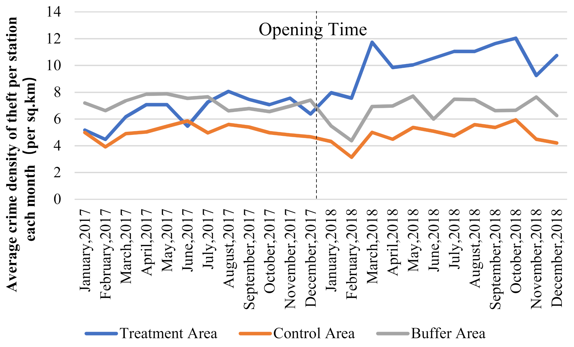
We calculate theft density in the treatment area, buffer area, and control area in 2017 and 2018 by month (Figure 5). After the implementation of new subway stations, the theft density increases from 4 to 8 per km2 to 12 per km2 in the treatment area, while the theft density stays around 4–6 per km2 throughout the study period in the control area. As shown in Figure 5, it can be seen that before and after the opening of the subway station, the crime trends of the buffer zone and the control zone tend to be the same, and are not affected by the opening of the subway. Only the treatment area shows an obvious change trend. It can be confirmed that there is no strong contamination between the treatment area, the buffer area, and the control area in the range setting. Clearly, theft trends in the treatment area and control area are different after the implementation of new subway stations.
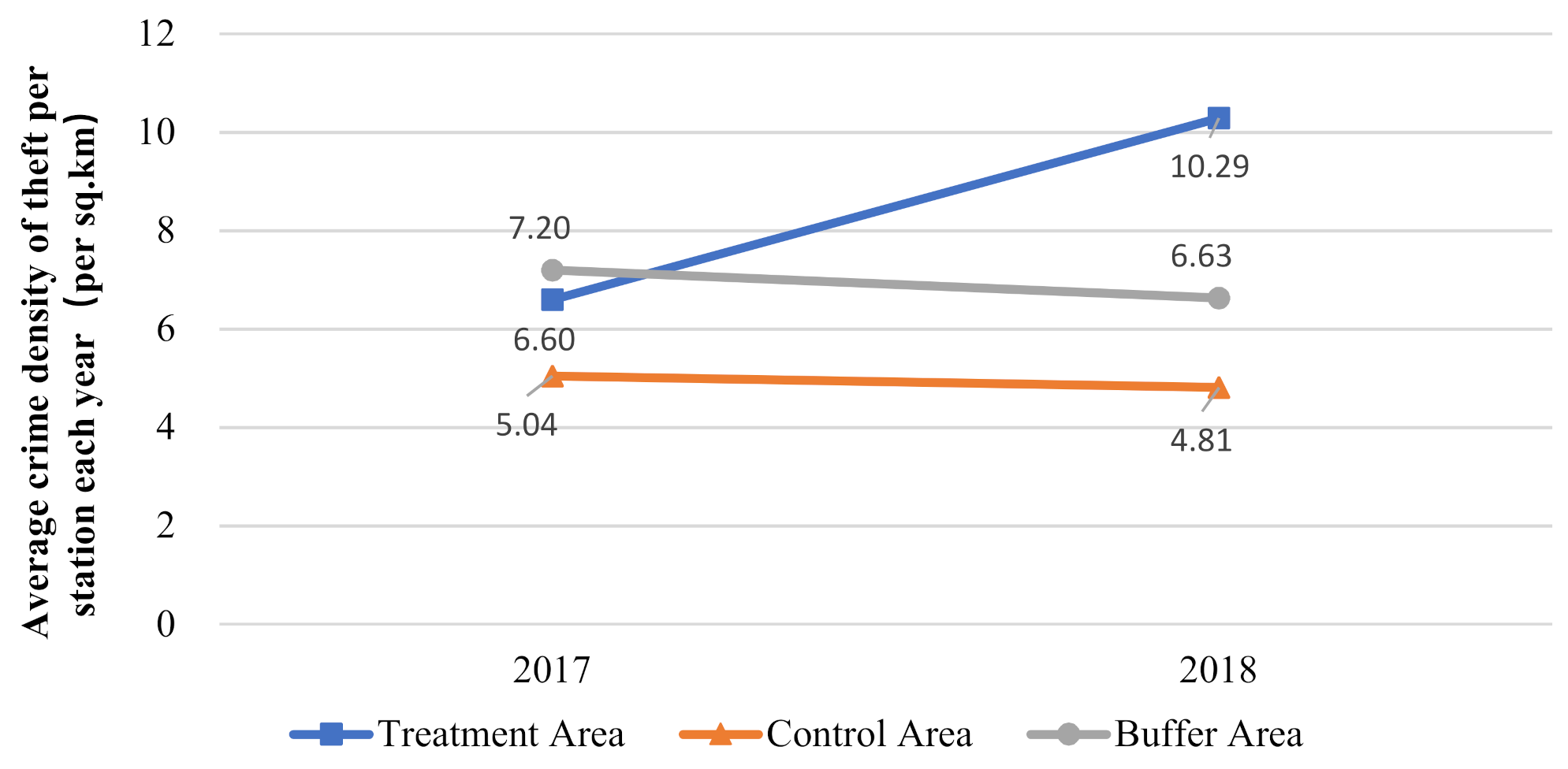
Figure 6 shows the annual average theft density in the treatment area and control area in 2017 and 2018. From 2017 to 2018, theft density increases by 55.91% in the treatment area, while it slightly decreases in the control area. It can be found that the case densities in the control area and in the buffer area are basically on the same decreasing trend. Given that the most obvious change in the treatment area is the implementation of new subway stations, the different trends of the theft density in treatment and control areas suggest the possible relationship between the stations and increase in theft. We also test this with DID regression models.

4.2. Results of the DID Model

As Table 4 shows, the variable Dummy interaction is related to thefts at the significance level of 0.001, and the coefficient is 0.611. This means, as hypothesized, that the new subway stations indeed correlate with nearby increase in theft after the stations’ implementation in 2017. The model’s R2 is 0.669, and the adjusted R2 is 0.663, indicating that more than 66.3% of the variance in dependent variables can be explained by this DID model. The variance inflation factor (VIF) of each variable is less than 7, indicating the model does not suffer from the serious multicollinearity problem [105]. It is not unusual that the dummy variables are highly correlated in the DID model.
The coefficient of Time from addition is positive, but not statistically significant. Thus, the increase in thefts around the new subway stations over time may be non-linear. This may be related to the influence of the Spring Festival. The variable Spring Festival is significantly negatively related to thefts, indicating that thefts significantly decrease during the months of the Spring Festival, as hypothesized. This is because during the Spring Festival, people who work in the city are most likely to return to their hometowns, and the ridership and crime opportunities in/around subway stations decrease accordingly. The motivated offender may need to exert more effort to commit thefts with higher risk. Rational offenders may look for other opportunities during this time. The significant negative relationship between thefts and the natural logarithm of the distance between the subway stations indicates possible spillover effects between the neighboring stations: the closer the stations are, the more numerous the thefts.
Schools have a significant negative relationship with thefts, which is different from the findings in American and European cities [94,106], but aligns well with findings in other Chinese cities [107,108]. In China, teachers, security guards, and staff in schools, as well as students and their parents, are likely to act as capable guardians, and thus reduce crime opportunities around schools [108]. Shopping malls, bars, hotels, and internet bars all positively correlate with thefts. The large ambient population but weak guardianship in such areas may generate more crime opportunities [91,97,109]. The percentages of the young population are positively correlated with thefts, as indicated in previous studies [110,111,112,113,114,115,116].
In summary, the DID model’s results show that, as hypothesized, the implementation of new subway stations in 2017 significantly attracted more thefts to the nearby area (<400 m), and the Spring Festival did witness fewer thefts. However, the time from addition does not have any significant impacts on thefts.

5. Discussion and Conclusions

The test on the potential causal impact of new subway stations on crime is rare in China. We used a quasi-experimental design, a DID regression model, and necessary control factors to test the relationship between thefts and new subway stations. Unlike the findings from the previous studies arguing no relationship between crime and new railway transit stations [47], we found a significant positive relationship between thefts and new subway stations, that is to say, new subway stations indeed attract more thefts to the nearby areas after their implementation. The possible reason may be related to the differences between light rail transit [47] and subway transit, though they are both considered railway transit. Light rail transit is on the ground, and the function of station buildings is obvious and specific. Only light rail riders and light rail operators are likely to visit the stations. The security equipment of the stations, such as cameras, may deter motivated offenders, while subway stations are usually underground and do not obviously alter the building structures on the ground. The station exits on the ground usually have limited security surveillance and may not deter motivated offenders sufficiently. Consequently, new stations of light rail transit and subway may have different impacts on nearby crime.
Our findings are consistent with the rational choice theory. Rational offenders usually evaluate the risk, effort, and potential gain before committing crime. Only when the risk and effort are marginal while potential gain is considerable will they take action. The implementation of new subway stations attracts a large population and provides more crime opportunities because guardianship among strangers is weak. Potential offenders can take advantage of the convenient transportation, concentrated crime opportunities, and weakened guardianship to commit thefts and flee from the scene.
However, this study also has a few limitations. First, we used socioeconomic data in 2010 and POI data in 2016 as controls in the DID model to study thefts that occurred in 2017 and 2018. Changes in the socio-economic data and POI from 2017 and 2018 are not available and thus, were not implemented in the model. However, the 2016 data are the most up-to-date data and are closest to the study period; therefore, they are the most logical choice. Second, the coverage of Line 9 and Line 13 is in suburban districts, rather than CBDs of the city. Is it possible that thefts are displaced from the CBDs to the suburban districts? We examined the temporal change of thefts between the two years. Compared with 2017, thefts decreased significantly in YB/DH/PH and most of the other districts in ZG city in 2018. The only exception is the CZ District, where thefts increased slightly. It appears that crime displacement from the CBD to these four suburban districts is not very likely, although future studies are needed to further examine this issue. Further, subway stations tend to attract not only thefts, but also robberies [117,118]. However, this study only focused on thefts. Robberies are left to future studies. Last but not least, because of the data limitation, we did not analyze passenger numbers, a key variable that can represent “potential victims”.
Nonetheless, this study contributes to inferring the possible causal effect between the subway and theft. The key findings are as follows: (1) theft increases after the implementation of new subway stations in their nearby areas, while it decreases in the areas without new subway stations; (2) locating multiple subway stations in proximity could further increase theft; and (3) theft decreases around subway stations during the Spring Festival because of the decrease in ridership. In addition to the scholarly contributions, the findings in the study bring insights into the planning of subway transits in urban settings and public safety. The operating organization of the subway should pay special attention to the security measures in and around stations to prevent crime. Local law enforcement forces also need to optimize their patrol strategies to adapt to the change in crime opportunities.

Author Contributions

Data curation, D.C.; Methodology, M.L.; Writing—original draft, C.X. and X.C.; Writing—review & editing, L.L. All authors have read and agreed to the published version of the manuscript.

Funding

This research was funded by the National Key R&D Program of China, grant number 2018YFB0505500, 2018YFB0505505, and the National Natural Science Foundation of China, grant number 41601138.

Institutional Review Board Statement

Not applicable.

Informed Consent Statement

Not applicable.

Data Availability Statement

Because the agreement is limited, crime data does not allow to disclose the source and details. POI data is from Gaode Map (https://www.amap.com/) and Daodaotong Map (https://www.ritu.cn/), social data and economic data are from the official website of the National Bureau of Statistics of China (http://www.stats.gov.cn/tjsj/pcsj/rkpc/6rp/indexch.htm).

Conflicts of Interest

The authors declare no conflict of interest.

References

  1. Capone, D.L.; Nichols, W.W. Urban Structure and Criminal Mobility. Am. Behav. Sci. 1976, 20, 199–213. [Google Scholar] [CrossRef]
  2. Smith, M.J.; Clarke, R.V. Crime and Public Transport. Crime Justice 2000, 27, 169–233. [Google Scholar] [CrossRef]
  3. Hart, T.C.; Miethe, T.D. Public Bus Stops and the Meso Environment: Understanding the Situational Context of Street Robberies. In Safety and Security in Transit Environments; Palgrave Macmillan: London, UK, 2015. [Google Scholar]
  4. Levine, N.; Wachs, M. Bus crime in Los Angeles: I—Measuring the incidence. Transp. Res. Part A Gen. 1986, 20, 273–284. [Google Scholar] [CrossRef]
  5. Levine, N.; Wachs, M. Bus crime in Los Angeles: II—Victims and public impact. Transp. Res. Part A Gen. 1986, 20, 285–293. [Google Scholar] [CrossRef]
  6. Loukaitou-Sideris, A. Hot Sports of Bus Stop Crime: The Importance of Environmental Attributes. J. Am. Plan. Assoc. 1996, 65, 395–411. [Google Scholar] [CrossRef]
  7. Oliveira, E.; Natarajan, M.; Da Silva, B. Bus robberies in Belo Horizonte. Solut. Safe Travel Crime Delinq. 2019. [Google Scholar] [CrossRef]
  8. Pearlstein, A.; Wachs, M. Crime in public transit systems: An environmental design perspective. Transportation 1982, 11, 277–297. [Google Scholar] [CrossRef]
  9. Plano, L.S. Transit-generated crime: Perception versus reality—A sociogeographic study of neighborhoods adjacent to section b of baltimore metro. Transp. Res. Rec. 1993, 1402, 59–62. [Google Scholar]
  10. Loukaitou-Sideris, A.; Liggett, R.; Iseki, H.; Thurlow, W. Measuring the effects of built environment on bus stop crime. Environ. Plan. B Plan. Des. 2001, 28, 255–280. [Google Scholar] [CrossRef]
  11. Block, R.; Block, C. The Bronx and Chicago: Street Robbery in the Environs of Rapid Transit Stations. Anal. Crime Patterns Front. Pract. 2000, 2000, 137–152. [Google Scholar]
  12. Poister, T.H. Transit-related crime in suburban areas. J. Urban Aff. 1996, 18, 63–75. [Google Scholar] [CrossRef]
  13. Liu, L.; Jiang, C.; Zhou, S.; Liu, K.; Du, F. Impact of Public Bus System on Spatial Burglary Patterns in a Chinese Urban Context. Appl. Geogr. 2017, 89, 142–149. [Google Scholar] [CrossRef]
  14. Liu, L.; Lan, M.; Eck, J.E.; Kang, E.L. Assessing The Effects of Bus Stop Relocation on Street Robbery. Comput. Environ. Urban Syst. 2020, 80, 101455. [Google Scholar] [CrossRef]
  15. Block, R.; Davis, S. The environs of rapid transit stations: A focus for street crime or just another risky place? Prev. Mass Transit Crime 1996, 6, 237–257. [Google Scholar]
  16. Loukaitou-Sideris, A.; Liggett, R.; Iseki, H. The Geography of Transit Crime: Documentation and Evaluation of Crime Incidence on and around the Green Line Stations in Los Angeles. J. Plan. Educ. Res. 2002, 22, 135–151. [Google Scholar] [CrossRef]
  17. Ridgeway, G.; MacDonald, J.M. Effect of Rail Transit on Crime: A Study of Los Angeles from 1988 to 2014. J. Quant. Criminol. 2017, 33, 277–291. [Google Scholar] [CrossRef]
  18. Gaziarifoglu, Y.K.L.W. Robbery Risk as a Co-Function of Place and Time; Rutgers Center on Public Security: Newark, NJ, USA, 2012. [Google Scholar]
  19. Degeneste, H.I.; Sullivan, J.P. Policing Transportation Facilities; Charles C Thomas: Springfield, IL, USA, 1994. [Google Scholar]
  20. van Wilsem, J. Urban Streets as Micro Contexts to Commit Violence Putting Crime in Its Place; Springer: New York, NY, USA, 2009; pp. 199–216. [Google Scholar]
  21. Stucky, T.D.; Smith, S.L. Exploring the conditional effects of bus stops on crime. Secur. J. 2017, 30, 290–309. [Google Scholar] [CrossRef] [Green Version]
  22. Gerell, M. Bus Stops and Violence, Are Risky Places Really Risky? Eur. J. Crim. Policy Res. 2018, 24, 351–371. [Google Scholar] [CrossRef] [Green Version]
  23. Ross, C.; Stein, J.M. Business and residential perceptions of a proposed rail station: Implications for transit planning. Transp. Q. (USA) 1985, 39, 483–493. [Google Scholar]
  24. O’Toole, R. Roadmap to Gridlock: The Failure of Long-Range Metropolitan Transportation Planning. SSRN Electron. J. 2008, 617. [Google Scholar] [CrossRef] [Green Version]
  25. The Antiplanner. More on Light Rail Transit Crime. Available online: http://ti.org/antiplanner/?p=248 (accessed on 16 September 2021).
  26. Cohen, L.E.; Felson, M. Social Change and Crime Rate Trends: A Routine Activity Approach. Am. Soc. Rev. 1979, 44, 588–608. [Google Scholar] [CrossRef]
  27. Cohen, L.E.; Land, F.K.C. Property Crime Rates in the United States: A Macrodynamic Analysis, 1947–1977; With Ex Ante Forecasts for the Mid-1980s. Am. J. Soc. 1980, 86, 90–118. [Google Scholar] [CrossRef]
  28. Hindelang, M.; Gottfredson, M.; Garofalo, J. Victims of Personal Crime: An Empirical Foundation for a Theory of Personal Victimization; Ballinger Pub.: Cambridge, UK, 1978. [Google Scholar]
  29. Ihlanfeldt, B.K.R. Identifying the Impacts of Rail Transit Stations on Residential Property Values. J. Urban Econ. 2001, 50, 1–25. [Google Scholar]
  30. Phillips, P.D. Characteristics and Typology of the Journey to Crime; Georges-Abeyie, D.E., Harries, K.D., Eds.; Columbia University Press: New York, NY, USA, 1980; pp. 167–180. [Google Scholar]
  31. Rengert, G.F.; Piquero, A.R.; Jones, P.R. Distance decay reexamined. Criminology 2010, 37, 427–446. [Google Scholar] [CrossRef]
  32. Rhodes, W.M.; Conly, C. Crime and Mobility: An Empirical Study; Brantingham, P.J., Brantingham, P.L., Eds.; Waveland Press: Prospect Heights, IL, USA, 1991; pp. 167–188. [Google Scholar]
  33. Spelman, W. Jobs or jails? The crime drop in Texas. J. Policy Anal. Manag. 2005, 24, 133–165. [Google Scholar] [CrossRef]
  34. Carlson, J. Residents Split on Move Proposed for LRT Stop; Star Tribune: Minneapolis, MN, USA, 2000; p. 3B. [Google Scholar]
  35. Ihlanfeldt, K.R. Rail transit and neighborhood crime: The case of Atlanta, Georgia. South Econ. J. 2003, 70, 273–294. [Google Scholar] [CrossRef]
  36. Cao, L.; Maume, D.J. Urbanization, Inequality, Lifestyles and Robbery: A Comprehensive Model. Soc. Focus 1993, 26, 11–26. [Google Scholar] [CrossRef]
  37. Brantingham, P.; Brantingham, P. Criminality of place: Crime generators and crime attractors. Eur. J. Crim. Policy Res. 1995, 13, 5–26. [Google Scholar] [CrossRef]
  38. Brantingham, P.; Brantingham, P. Crime pattern theory. Environ. Criminol. Crime Anal. 2013, 78–93. [Google Scholar] [CrossRef]
  39. Brantingham, P.J.; Brangtingham, P.L.; Wong, P.S. How public transit feeds private crime: Notes on the Vancouver “Skytrain” experience. Secur. J. 1991, 2, 91–95. [Google Scholar]
  40. Hart, T.C.; Miethe, T.D. Street robbery and public bus stops: A case study of activity nodes and situational risk. Secur. J. 2014, 27, 180–193. [Google Scholar] [CrossRef]
  41. Lan, M. Examining the Impact of Bus Stop Location Change on Robbery. Master’s Thesis, University of Cincinnati, Cincinnati, OH, USA, 2016. [Google Scholar]
  42. Qin, X.; Liu, L. Evaluating the Relationships of Bus Transit with Street and Off-Street Robberies. Prof. Geogr. 2016, 68, 227–237. [Google Scholar] [CrossRef]
  43. Phillips, D.C.; Sandler, D. Does public transit spread crime? Evidence from temporary rail station closures. Reg. Ence Urban Econ. 2015, 52, 13–26. [Google Scholar] [CrossRef]
  44. Herrmann, C.R.; Maroko, A.R.; Taniguchi, T.A. Subway Station Closures and Robbery Hot Spots in New York City—Understanding Mobility Factors and Crime Reduction. Eur. J. Crim. Policy Res. 2021, 1–18. [Google Scholar] [CrossRef]
  45. Estévez-Soto, P.R. Crime and COVID-19: Effect of changes in routine activities in Mexico City. Crime Sci. 2020, 10, 15. [Google Scholar] [CrossRef] [PubMed]
  46. Deangelo, G.; Gittings, K.; Grossman, D.S.; Khalil, U. Urban transport and crime: Evidence from unanticipated mass transit strikes. Econ. Inq. 2019, 57, 1718–1737. [Google Scholar] [CrossRef]
  47. Billings, S.B.; Leland, S.; Swindell, D. The effects of the announcement and opening of light rail transit stations on neighborhood crime. J. Urban Aff. 2011, 33, 549–565. [Google Scholar] [CrossRef]
  48. Sedelmaier, C.M. Railroaded: The Effects of a New Public Transport System upon Local Crime Patterns; Rutgers The State University of New Jersey–Newark: New Brunswick, NJ, USA, 2003. [Google Scholar]
  49. Sedelmaier, C.M. ‘Wolves to the Door’ or ‘Lambs to the Slaughter’? Crime Opportunity Searches on a New Public Transport System; Palgrave Macmillan: London, UK, 2015. [Google Scholar]
  50. Cools, M.; Moons, E.; Wets, G. Assessing the Impact of Public Holidays on Travel Time Expenditure: Differentiation by Trip Motive. Transp. Res. Rec. J. Transp. Res. Board 2010, 2157, 29–37. [Google Scholar] [CrossRef]
  51. Cohn, E.G.; Rotton, J. Even criminals take a holiday: Instrumental and expressive crimes on major and minor holidays. J. Crim. Justice 2003, 31, 351–360. [Google Scholar] [CrossRef]
  52. Ceccato, V.; Uittenbogaard, A.C. Space–Time Dynamics of Crime in Transport Nodes. Ann. Assoc. Am. Geogr. 2014, 104, 131–150. [Google Scholar] [CrossRef]
  53. Zhao, X.; Gu, B. Statistical Analysis of Urban Rail Transit Lines in 2018 China. Urban Mass Transit 2019, 22, 1–7. [Google Scholar]
  54. Liu, D.; Song, W.; Xiu, C. Spatial Analysis on Robbery, Forcible Seizure, Vehicle Theft and Burglary in Changchun. Sci. Geogr. Sin. 2014, 34, 1344–1352. [Google Scholar]
  55. Yan, J.; Shu, X.; Yuan, H. Relationship Between Spatial Distribution of Thief Crime and Geographical Factors. J. Tsinghua Univ. (Sci. Technol.) 2010, 2, 174–176. [Google Scholar]
  56. Transport Department of Guangdong Province, Data on The Operation of Urban Rail Transit Nationwide Were Released. Available online: http://www.mot.gov.cn/difangxinwen/xxlb_fabu/fbpd_guangdong/202101/t20210111_3513911.html (accessed on 15 February 2021).
  57. Chen, W.; Liu, L.; Liang, Y. Characterizing the spatio-temporal evolution of retail business at transfer hubs of Guangzhou Metro. Acta Geogr. Sin. 2015, 70, 879–892. [Google Scholar]
  58. Xie, X. Discussion on fire safety risk control of underground commercial facilities in subway. Technol. Wind. 2017, 11, 216. [Google Scholar]
  59. Yang, Z. Seek Truth from Facts, and Seek “Good” from the Perspective of Urban Subway Planning in China and the Decision Principle of Scientific Value. Explor. Free. Views 2005, 11, 51–54. [Google Scholar]
  60. Guangzhou Metro. Annual Report in 2017. Available online: http://www.gzmtr.com/ygwm/gsgk/qynb/201806/t20180627_57628.html (accessed on 4 August 2020).
  61. Guangzhou Metro. Annual Report in 2018. Available online: http://www.gzmtr.com/ygwm/gsgk/qynb/201906/t20190610_63268.html (accessed on 4 August 2020).
  62. Ashenfelter, O.C.; Card, D. Using the Longitudinal Structure of Earnings to Estimate the Effect of Training Programs. Rev. Econ. Stat. 1985, 67, 648–660. [Google Scholar] [CrossRef]
  63. Adan, H.; Fuerst, F. Do energy efficiency measures really reduce household energy consumption? A difference-in-difference analysis. Energy Effic. 2015, 9, 1207–1219. [Google Scholar] [CrossRef] [Green Version]
  64. Rivers, N.; Shenstone-Harris, S.; Young, N. Using nudges to reduce waste? The case of Toronto’s plastic bag levy. J. Environ. Manag. 2017, 188, 153–162. [Google Scholar] [CrossRef]
  65. Yang, S.; Wang, F.; Liu, N. Assessment of the Air Pollution Prevention and Control Action Plan in China: A Difference-in-Difference analysis. China Popul. Resour. Environ. 2020, 30, 110–117. [Google Scholar]
  66. Li, J.; Xin, D.; Song, C. Poverty Reduction Effect of High-speed Rail Opening—An Empirical Study of 280 Cities at the Prefecture Level and above Based on the DID Method in China. J. Anhui Norm. Univ. 2020, 48, 128–138. [Google Scholar]
  67. Priks, M. The Effects of Surveillance Cameras on Crime: Evidence from the Stockholm Subway. Econ. J. 2015, 125, F289–F305. [Google Scholar] [CrossRef]
  68. Cerezo, A. CCTV and crime displacement: A quasi-experimental evaluation. Eur. J. Criminol. 2013, 10, 222–236. [Google Scholar] [CrossRef]
  69. Coyne, C.A.; Fontaine, N.M.; Långström, N.; Lichtenstein, P.; D’Onofrio, B.M. Teenage childbirth and young adult criminal convictions: A quasi-experimental study of criminal outcomes for teenage mothers. J. Crim. Justice 2013, 41, 318–323. [Google Scholar] [CrossRef] [Green Version]
  70. Cunningham, S.; Engelstatter, B.; Ward, M.R. Violent Video Games and Violent Crime. South. Econ. J. 2016, 82, 1247–1265. [Google Scholar] [CrossRef]
  71. Calthorpe, P. The Next American Metropolis: Ecology, Community & the American Dream; Princeton Architectural Press: New York, NY, USA, 1993. [Google Scholar]
  72. Duany, A.; Plater-Zyberk, E. The neighbourhood, the district, and the corridor. New Urban. Towar. Archit. Community 1994, 1994, 17–20. [Google Scholar]
  73. Iacono, M.J.; Krizek, K.J.; Elgeneidy, A.M. Access to Destinations: How Close Is Close Enough? Estimating Accurate Distance Decay Functions for Multiple Modes and Different Purposes. Available online: https://conservancy.umn.edu/bitstream/handle/11299/151329/Mn_DOT2008-11.pdf?sequence=1&isAllowed=y (accessed on 10 September 2021).
  74. Kimpel, T.J.; Dueker, K.J.; El-Geneidy, A.M. Using GIS to measure the effect of overlapping service areas on passenger boardings at bus stops. Urisa J. 2007, 19, 5–11. [Google Scholar]
  75. Roukouni, A.; Basbas, S.; Kokkalis, A. Impacts of a Metro Station to the Land Use and Transport System: The Thessaloniki Metro Case. Procedia-Soc. Behav. Sci. 2012, 48, 1155–1163. [Google Scholar] [CrossRef] [Green Version]
  76. Hakim, S.; Rengert, G.F. Crime Spillover; Sage Publications: Thousand Oaks, CA, USA, 1981. [Google Scholar]
  77. Du, Q. Crime transfer. Chin. J. Soc. 1991, 33. [Google Scholar] [CrossRef]
  78. Liu, L.; Li, L.; Zhou, H.; Jiang, C.; Lan, M. The Effects of Police CCTV Camera on Crime Displacement and Diffusion of Benefits: A Case Study from Gusu District in Suzhou, China. Sci. Geogr. Sin. 2020, 40, 1601–1609. [Google Scholar]
  79. Na, S.; Yong, C. Analysis of Beijing Accommodation Service Based on Gaode POI. J. Green Sci. Technol. 2019, 6, 163–164 + 169. [Google Scholar]
  80. Wu, X.; Li, Y.; Wang, J.; Zhang, Y.; Huang, J. Spatial Pattern Analysis of Living Facilities in Chengdu Urban Area Based on POI Data. J. Geomat. 2019, 44, 122–126. [Google Scholar]
  81. Xue, B.; Li, J.; Xiao, X.; Xie, X.; Lu, C.; Rren, W.; Jiang, L. Overview of Man-Land Relationship Research Based on POI Data: Theory, Method and Application. Geogr. Geo-Inf. Sci. 2019, 35, 51–60. [Google Scholar]
  82. Weisburd, D.L.; Maher, L.; Sherman, L.W.; Buerger, M.; Petrosino, A. Contrasting crime general and crime specific theory: The case of hot spots of crime. Adv. Criminol. Theory 1993, 4, 45–69. [Google Scholar]
  83. Weisburd, D.; Telep, C.W.; Lawton, B.A. Could Innovations in Policing have Contributed to the New York City Crime Drop even in a Period of Declining Police Strength?: The Case of Stop, Question and Frisk as a Hot Spots Policing Strategy. Justice Q. 2014, 31, 129–153. [Google Scholar] [CrossRef]
  84. Weisburd, D. The law of crime concentration and the criminology of place. Criminology 2015, 53, 133–157. [Google Scholar] [CrossRef]
  85. Soares, R.R. Development, crime and punishment: Accounting for the international differences in crime rates. J. Dev. Econ. 2004, 73, 155–184. [Google Scholar] [CrossRef]
  86. Bell, N.L.; Adam, K.H.; Jones, R.J.; Johnson, R.D.; Mtandavari, Y.F.; Burch, G.; Cave, V.; Cameron, C.; Maclean, P.; Popay, A.J.; et al. Detection of Invertebrate Suppressive Soils, and Identification of a Possible Biological Control Agent for Meloidogyne Nematodes Using High Resolution Rhizosphere Microbial Community Analysis. Front. Plant Sci. 2016, 7, 1946. [Google Scholar] [CrossRef] [Green Version]
  87. Liu, R. Research on Propagation and Control of Holiday Passenger Flow in Urban Rail Transit. Master’s Thesis, Beijing University of Civil Engineering and Architecture, Beijing, China, 2017. [Google Scholar]
  88. Yan, D.; Zhou, J.; Zhao, Y.; Wu, B. Short-Term Subway Passenger Flow Prediction Based on ARIMA. Geo-Spat. Knowl. Intell. 2018, 848, 464–479. [Google Scholar]
  89. Liu, W.; Shi, E. Spatial Pattern of Population Daily Flow Among Cities Based on ICT: A Case Study of “Baidu Migration”. Acta Geogr. Sin. 2016, 71, 1667–1679. [Google Scholar]
  90. Liu, Y.; Wang, X.; Zhou, S.; Wu, W. The association between spatial access to physical activity facilities within home and workplace neighborhoods and time spent on physical activities: Evidence from Guangzhou. Int. J. Health Geogr. 2020, 19, 22. [Google Scholar] [CrossRef]
  91. Bromley, R.D.F.; Nelson, A.L. Alcohol-related crime and disorder across urban space and time: Evidence from a British city. Geoforum 2002, 33, 239–254. [Google Scholar] [CrossRef]
  92. Faggiani, D.W.R.A. High Schools and Crime: A Replication. Soc. Q. 1985, 26, 491–505. [Google Scholar]
  93. Hollinger, R.C.; Dabney, D.A. Motor Vehicle Theft at the Shopping Centre: An Application of the Routine Activities Approach. Secur. J. 1999, 12, 63–78. [Google Scholar] [CrossRef]
  94. Murray, R.K.; Swatt, M.L. Disaggregating the Relationship Between Schools and Crime: A Spatial Analysis. Crime Delinq. 2013, 59, 163–190. [Google Scholar] [CrossRef]
  95. Sherman, L.W.; Gartin, P.R.; Buerger, M.E. Hot spots of predatory crime: Routine activities and the criminology of place. Criminology 2010, 27, 27–56. [Google Scholar] [CrossRef]
  96. Twinam, T. Danger Zone: The Causal Effects of High-Density and Mixed-Use Development on Neighborhood Crime. Ssrn Electron. J. 2014. [Google Scholar] [CrossRef]
  97. Willits, D.; Broidy, L.; Denman, K. Schools, Neighborhood Risk Factors, and Crime. Crime Delinq. 2013, 59, 292–315. [Google Scholar] [CrossRef]
  98. Bursik, R.J. Social disorganization and theories of crime and delinquency: Problems and prospects. Criminology 1988, 26, 519–552. [Google Scholar] [CrossRef]
  99. Bursik, R.J.; Webb, J. Community Change and Patterns of Delinquency. Am. J. Soc. 1982, 88, 24–42. [Google Scholar] [CrossRef]
  100. Shaw, C.R. A Delinquency Area; Behavior Research Fund Monographs; Moore, M.E., Ed.; University of Chicago Press: Chicago, IL, USA, 1931; pp. 13–25. [Google Scholar]
  101. Shaw, C.R.; Mckay, H.D. Juvenile Delinquency and Urban Areas. Soc. Serv. Rev. 1942, 35, 394. [Google Scholar] [CrossRef]
  102. Felson, M. The Routine Activity Approach as a General Crime Theory. In Criminological Perspectives: Essential Readings, 3rd ed.; SAGE Publications Ltd.: Thousand Oaks, CA, USA, 2000; Volume 2, pp. 160–167. [Google Scholar]
  103. Felson, M.; Cohen, L.E. Human ecology and crime: A routine activity approach. Hum. Ecol. 1980, 8, 389–406. [Google Scholar] [CrossRef]
  104. Fotheringham, A.S.; Yue, H.; Li, Z. Examining the influences of air quality in China’s cities using multi-scale geographically weighted regression. Trans. GIS 2019, 23, 1444–1464. [Google Scholar] [CrossRef]
  105. Man, J.; Yang, W. Based on Multiple Collinearity Processing Method. Math. Theory Appl. 2010, 30, 105–109. [Google Scholar]
  106. Wo, J.C.; Jihye, P. An Examination of Schools, Social Ecological Factors, and Neighbourhood Crime. Br. J. Criminol. 2020, 4, 851–872. [Google Scholar] [CrossRef]
  107. Song, G.; Bernasco, W.; Liu, L.; Xiao, L.; Zhou, S.; Liao, W. Crime Feeds on Legal Activities: Daily Mobility Flows Help to Explain Thieves’ Target Location Choices. J. Quant. Criminol. 2019, 35, 831–854. [Google Scholar] [CrossRef] [Green Version]
  108. Zhang, Y.; Zhu, C.; Qin, B. Spatial Distribution of Crime Number and Harm and The Influence of The Built Environment: A Longitudinal Research on Criminal Cases in Beijing. Prog. Geogr. 2019, 38, 1876–1889. [Google Scholar] [CrossRef]
  109. Jiang, X. Spatial Differentiation of the Impact of Urban Built Environment on Criminal Behavior. In Doctor’s Thesis; Harbin Institute of Technology: Harbin, China, 2018. [Google Scholar]
  110. Bennett, P. The Heterogeneous Effects of Education on Crime: Evidence from Danish Administrative Twin Data. Labour Econ. 2018, 52, 160–177. [Google Scholar] [CrossRef]
  111. Cabrera-Barona, P.F.; Jimenez, G.; Melo, P. Types of Crime, Poverty, Population Density and Presence of Police in the Metropolitan District of Quito. Int. J. Geo-Inf. 2019, 8, 558. [Google Scholar] [CrossRef] [Green Version]
  112. Dahlback, O. Modelling the Influence of Societal Factors on Municipal Theft Rates in Sweden: Methodological Concerns and Substantive Findings. Acta Soc. 1998, 41, 37–57. [Google Scholar] [CrossRef]
  113. Kassem, M.; Ali, A.; Audi, M. Unemployment Rate, Population Density and Crime Rate in Punjab (Pakistan): An Empirical Analysis. Available online: https://mpra.ub.uni-muenchen.de/95964/ (accessed on 10 September 2021).
  114. Liu, D.; Xiu, C.; Yu, J. Spatial Analysis of Property Crimes in Changchun. Sci. Geogr. Sin. 2012, 32, 477–484. [Google Scholar]
  115. Newman, O. Defensible Space: Crime Prevention Through Urban Design; American Political Science Association: Washington, WA, USA, 1975; p. 69. [Google Scholar]
  116. Weisburd, D.; Morris, N.A.; Groff, E.R. Hot Spots of Juvenile Crime: A Longitudinal Study of Arrest Incidents at Street Segments in Seattle, Washington. J. Quant. Criminol. 2009, 25, 443–467. [Google Scholar] [CrossRef]
  117. Clarke, R.; Belanger, M.; Eastman, J. Where Angels Fear to Tread: A Test in the New York City Subway of the Robbery/Density Hypothesis. In Preventing Mass Transit Crime: Crime Prevention Studies; Lynne Rienner Publishers: Boulder, CO, USA, 1996; Volume 6, pp. 217–236. [Google Scholar]
  118. Xiao, L.; Liu, L.; Zhou, H.; Song, W.; Zhang, X.; Chen, G. Spatio-temporal Pattern of Pickpocketing at Subway Stations on Weekdays of ZG City and Its Influencing Factors. Sci. Geogr. Sin. 2018, 38, 1227–1234. [Google Scholar]
Figure 1. Facilities related to the subway station: (a) near the subway station entrance; (b) inside the station (underground).
Ijgi 10 00632 g001
Figure 2. Passengers lining up into the check point (a) and passengers in the carriage (b).
Ijgi 10 00632 g002
Figure 3. Distance decay of thefts around new subway stations.
Ijgi 10 00632 g003
Figure 4. The treatment areas and control areas around new subway stations.
Ijgi 10 00632 g004
Figure 5. Theft density in treatment, buffer, and control areas from 2017 to 2018 by month.
Ijgi 10 00632 g005
Figure 6. Annual change in theft densities in treatment and control areas in 2017 and 2018.
Ijgi 10 00632 g006
Table 1. A partial comparison of Line 9 and Line 13 (in 2019).
Line 9Line 13
Construction starting date29/09/2009End of 2013
Operation starting date28/12/201728/12/2017
Total length20.1 km27.03 km
CoverageDH District, YB DistrictPH District, CZ District
Number of stations1111
Service time06:00–22:3006:00–23:19
Maximum speed120 km/h100 km/h
Connection with other linesThe northern extension of Line 3Line 5
Average daily ridership106,700 (2018)110,500 (2018)
Table 2. The attributes and definitions of variables.
AttributesDefinitions
Dependent variableLn(Theft density + 0.2)The natural logarithm of the theft density in the treatment area and the control area
Independent variablesDummy addition1 = Treatment Area, 0 = Control Area
Dummy 20181 = 2018, 0 = 2017
Dummy interactionThe multiplication of Dummy addition and Dummy 2018
Time from additionMonths from the implementation of the new subway stations
Dummy Spring festival1 for the month(s) during the festival, 0 otherwise
Distance to the nearest subway stationThe distance from one station to its nearest neighbor on lines 9 and 13
Control variablesDensity of schoolsThe density of schools in the area in 2016
Density of parks and squaresThe density of parks and squares in the area in 2016
Density of shopping mallsThe density of shopping malls in the area in 2016
Density of barsThe density of bars in the area in 2016
Density of hotelsThe density of hotels in the area in 2016
Density of internet barsThe density of Internet bars in the area in 2016
Density of hospitalsThe density of hospitals in the area in 2016
Density of banksThe density of banks in the area in 2016
Immigrant population rateThe proportion of the population who come from other cities in 2010
Young population rateThe proportion of the population who are 6 to 18 years old in 2010
Population densityThe density of population in 2010
Table 3. Descriptive statistics of variables.
Types of
Variables
AttributesMinimumMaximumMeanS.D.
Dependent variableLn(Theft percentage + 0.2)−1.614.020.951.68
Independent variablesDummy addition0.001.000.500.50
Dummy 20180.001.000.500.50
Dummy interaction0.001.000.250.43
Time from addition−12.0012.000.007.36
Dummy Spring Festival0.001.000.130.33
Log(Distance to nearest subway station + 0.001)3.003.473.210.14
Control variablesLog(Density of schools + 0.001)−3.000.60−0.981.42
Log(Density of parks and squares + 0.001)−3.000.39−2.061.36
Log(Density of shopping malls + 0.001)−3.000.60−1.021.39
Log(Density of bars + 0.001)−3.00−0.01−2.091.32
Log(Density of hotels + 0.001)−3.000.84−1.451.57
Log(Density of Internet bars + 0.001)−3.000.47−1.541.48
Log(Density of hospitals + 0.001)−3.000.29−1.541.47
Log(Density of banks + 0.001)−3.000.47−1.621.54
Log(Immigrant population rate + 0.001)−1.40−0.15−0.590.32
Log(Youth population rate + 0.001)−2.55−0.84−1.320.43
Log(Population density + 0.001)3.243.903.560.19
Table 4. Results of difference-in-differences model.
VariablesUnstandardized CoefficientsStandardized Coefficientst-testp-ValueVIF
Bβ
(constant)0.367-0.2890.773-
Dummy addition0.2610.0782.5780.0102.581
Dummy 2018−0.187−0.056−1.1550.2486.622
Dummy interaction0.6110.1574.850<0.0013.000
Time from addition0.0120.0511.0890.2776.353
Dummy Spring Festival−0.315−0.062−2.7800.0061.420
Log(Distance to nearest subway station + 0.001)−4.097−0.337−13.930<0.0011.666
Log(Density of schools + 0.001)−0.189−0.160−6.634<0.0011.649
Log(Density of parks and squares + 0.001)−0.028−0.022−1.0980.2731.178
Log(Density of shopping malls + 0.001)0.1010.0843.2740.0011.857
Log(Density of bars + 0.001)0.1200.0944.454<0.0011.278
Log(Density of hotels + 0.001)0.0960.0902.7110.0073.157
Log(Density of Internet bars + 0.001)0.4040.35514.066<0.0011.809
Log(Density of hospitals + 0.001)0.0390.0341.4250.1541.647
Log(Density of banks + 0.001)0.0050.0040.1220.9033.272
Log(Immigrant population rate+0.001)0.0450.0080.3190.7502.000
Log(Youth population rate + 0.001)0.3940.1024.568<0.0011.407
Log(Population density + 0.001)4.2350.48117.686<0.0012.102
Publisher’s Note: MDPI stays neutral with regard to jurisdictional claims in published maps and institutional affiliations.