
Local Climate Zones, Land Surface Temperature and Air Temperature Interactions: Case Study of Hradec Králové, the Czech Republic


Abstract
:1. Introduction
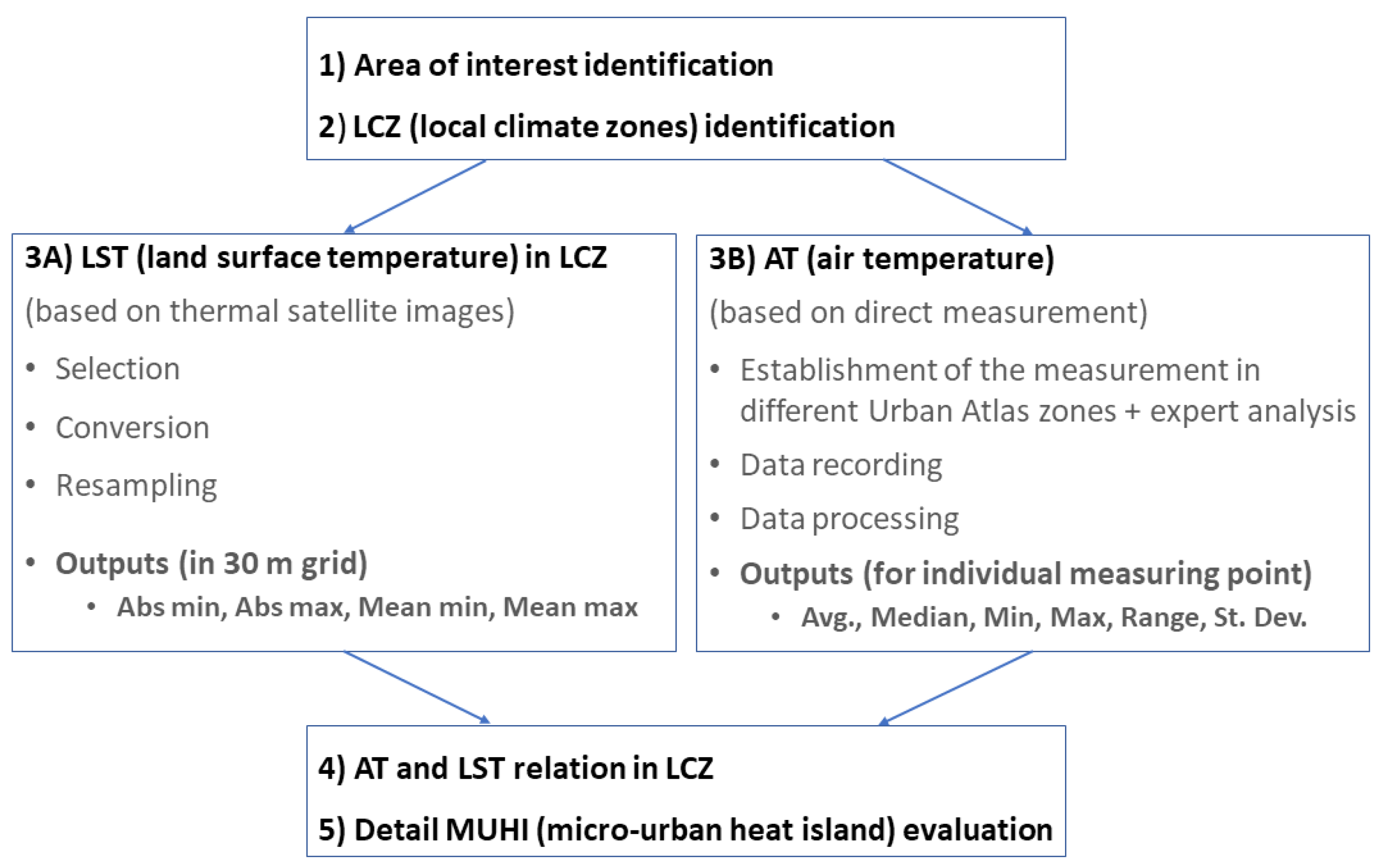
2. Materials and Methods
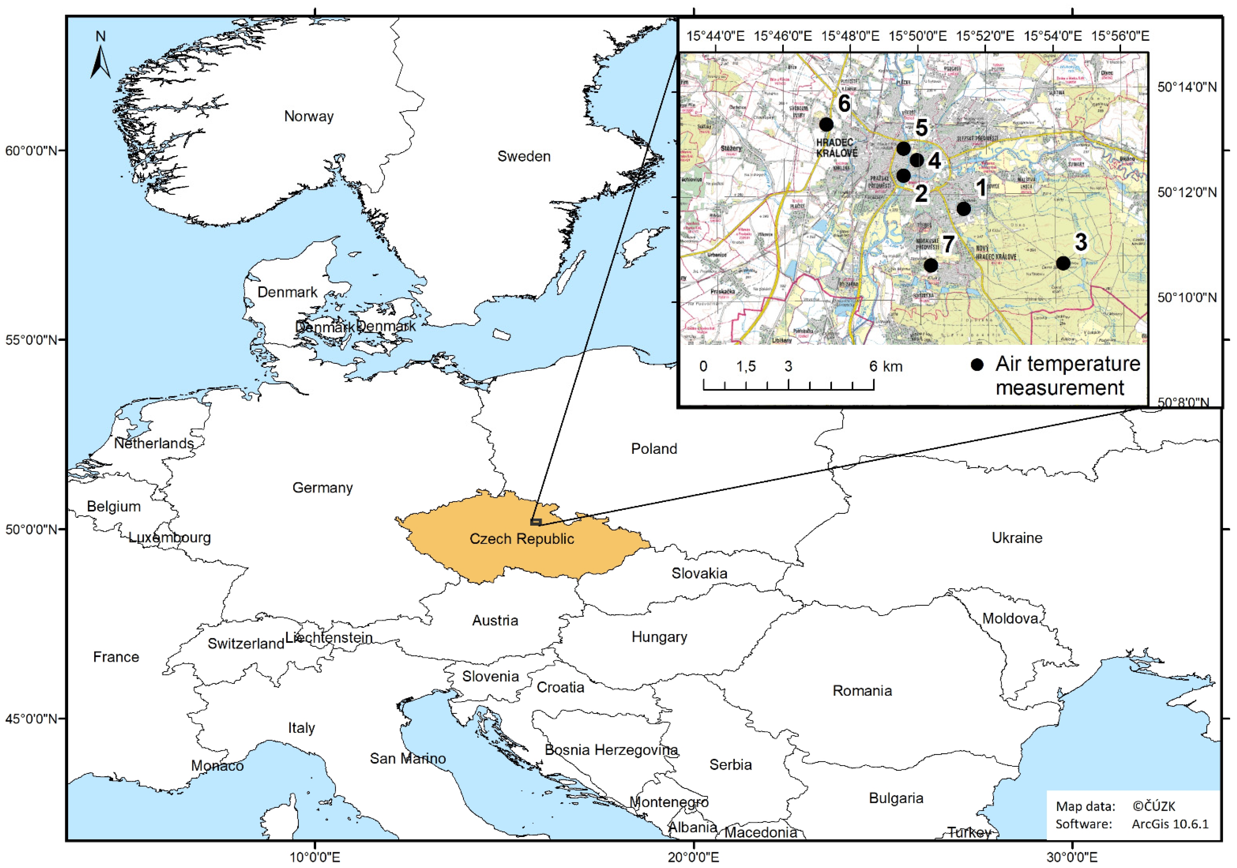
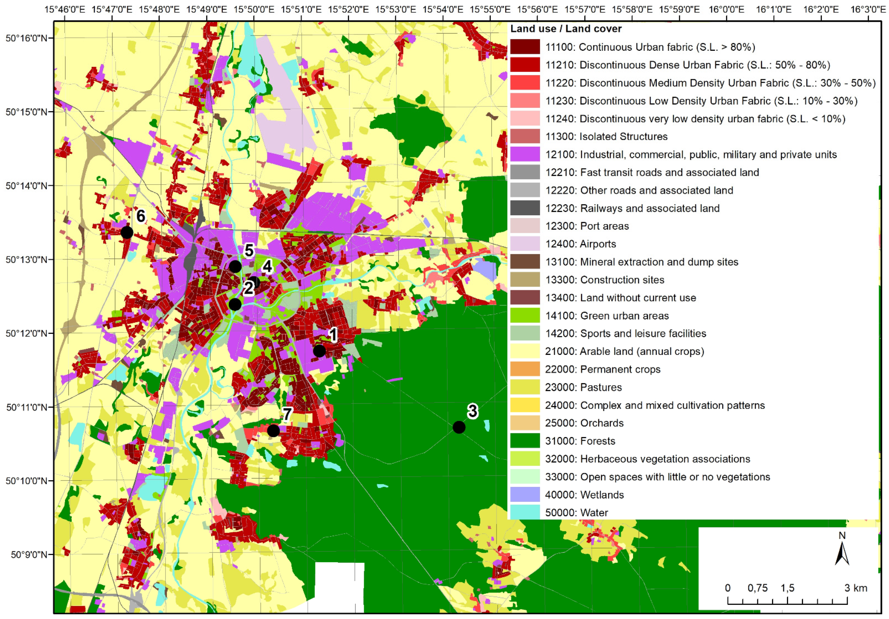
2.1. Area of Interest
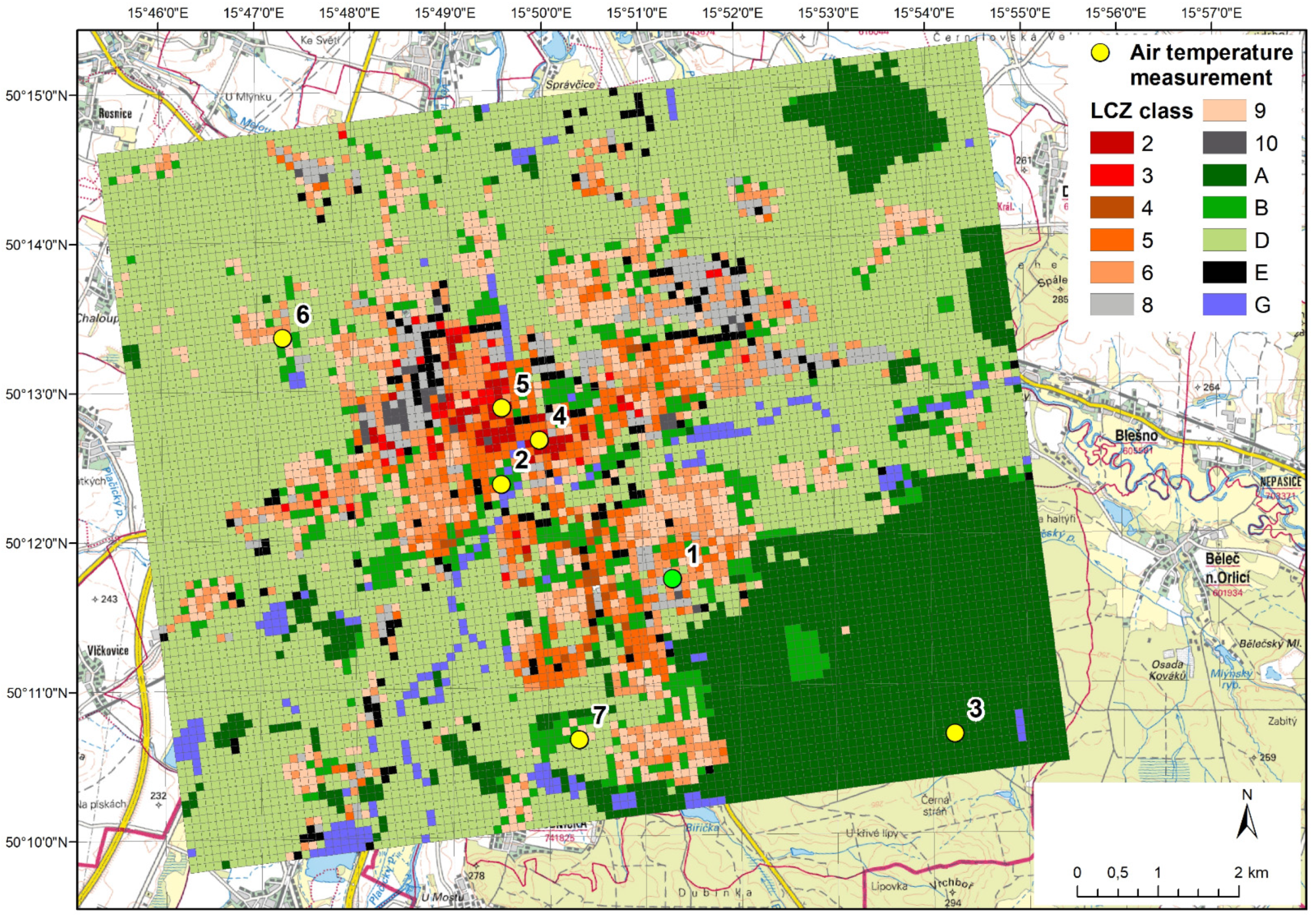
2.2. Local Climate Zones Identifacation
2.3. LST and AT Evaluation
2.4. LST and AT Relation in LCZ
2.5. MUHI Evaluation: Measurement of Surface Temperature and Temperature of Adjacent Air
3. Results
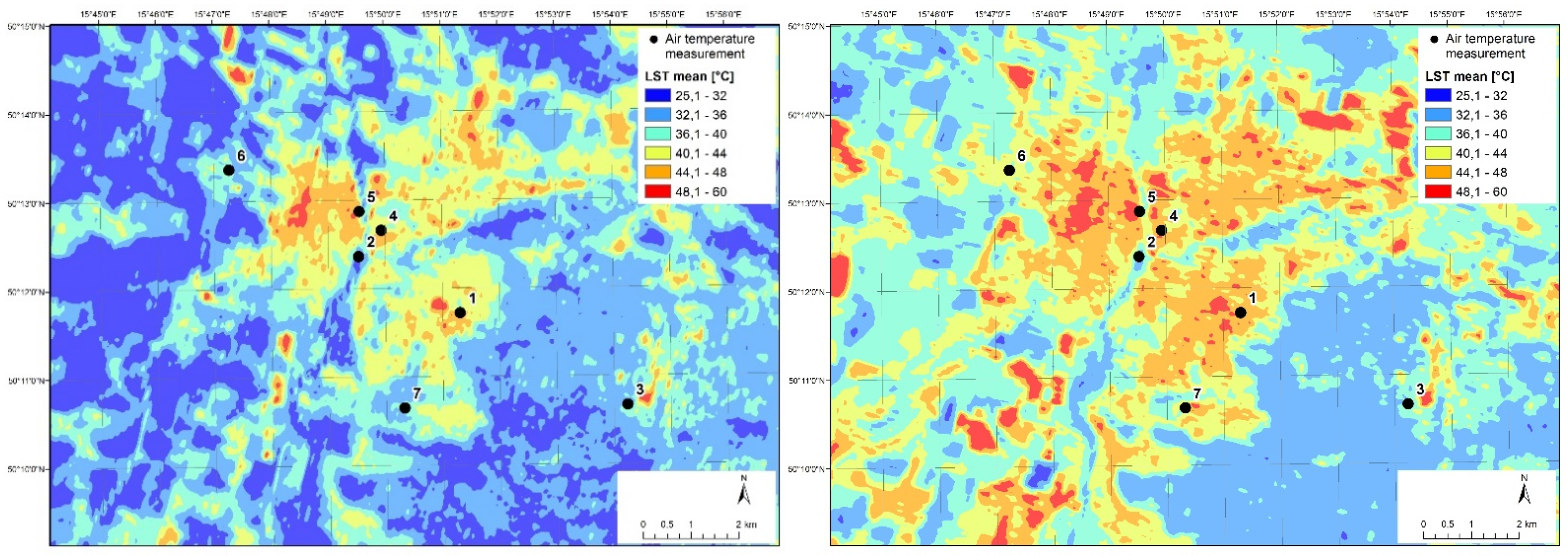
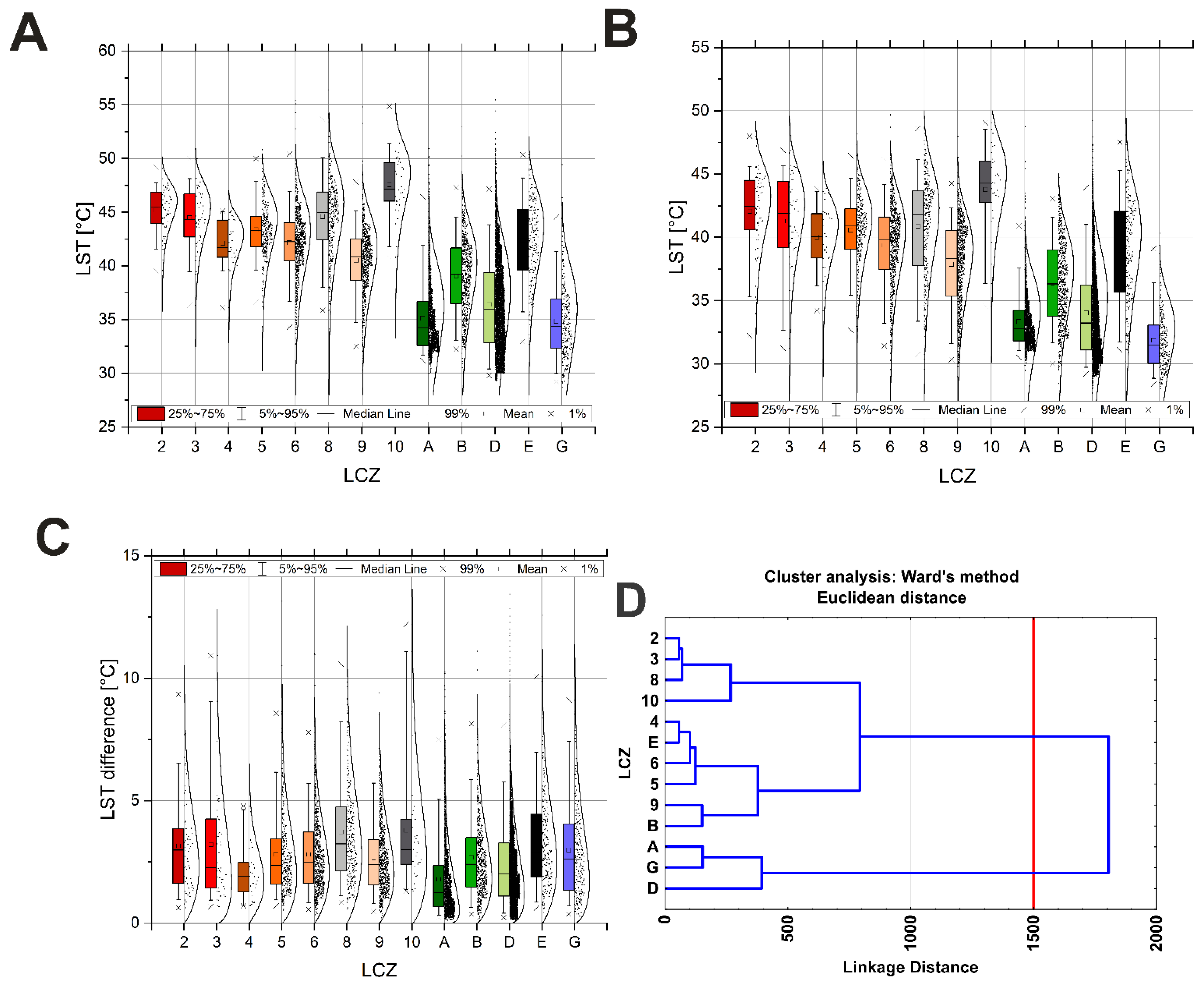
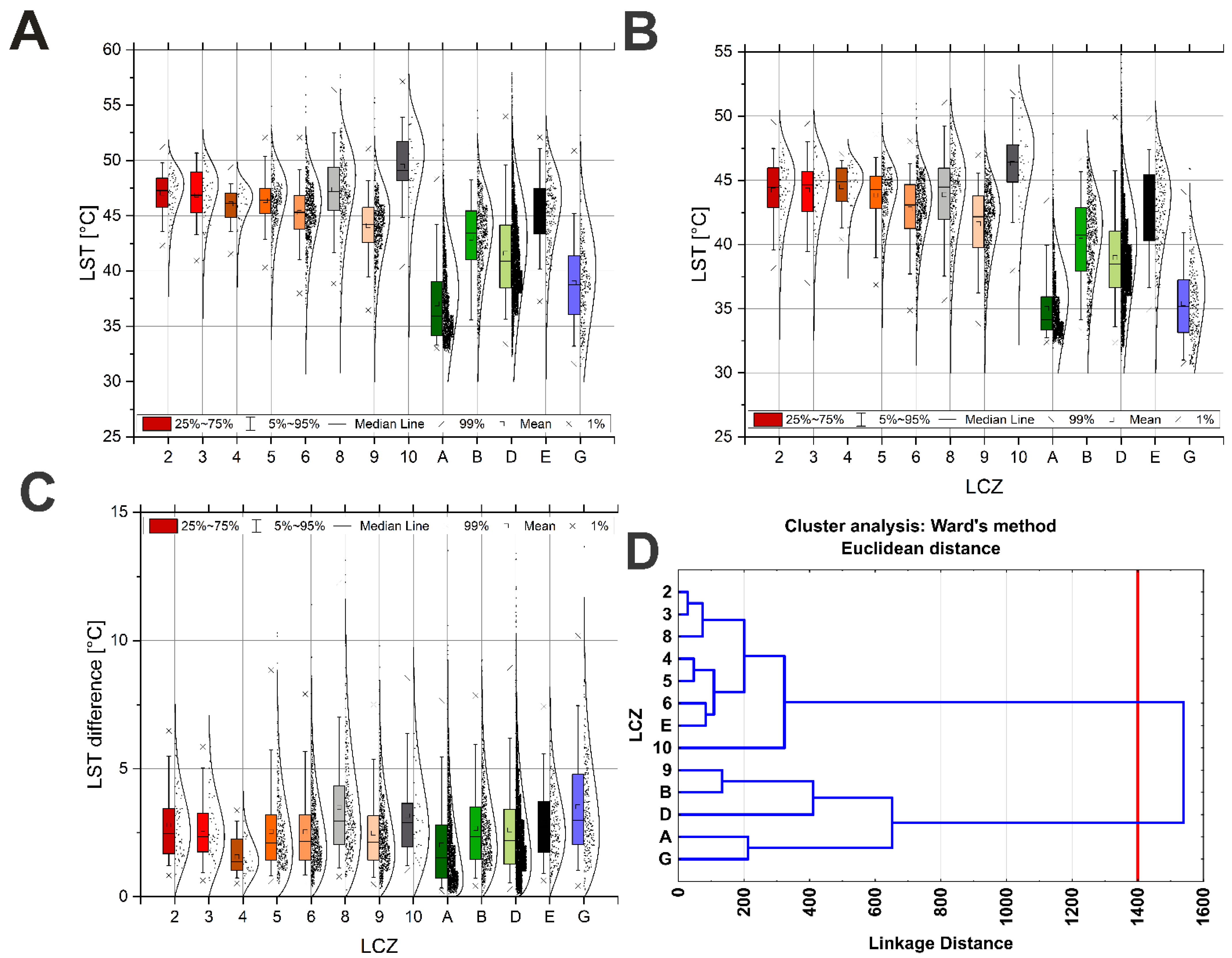
3.1. LST Evaluation
3.2. AT Evaluation
3.3. Interaction of LSTs Derived from Remote Sensing with Ground Monitoring of AT
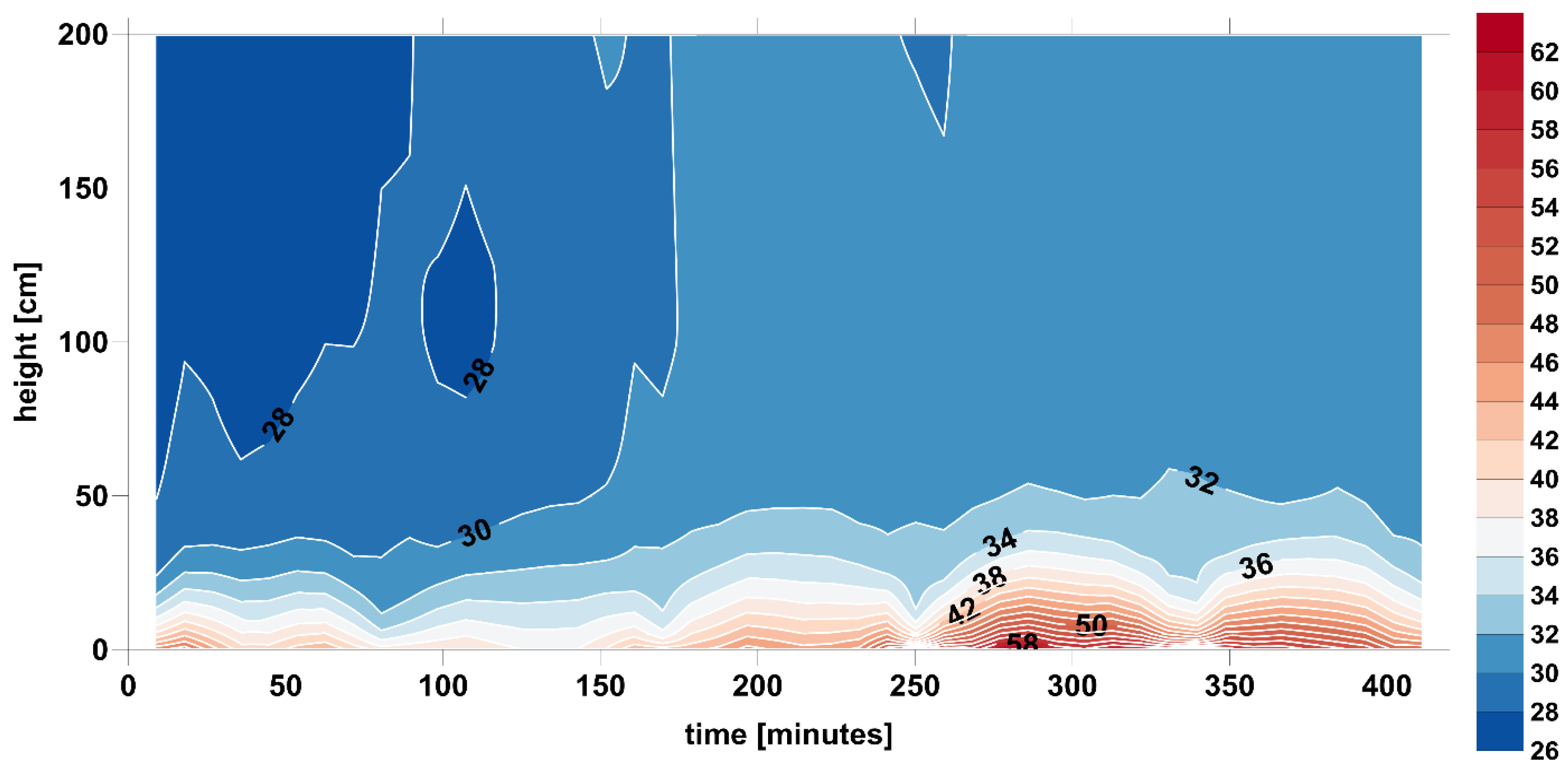
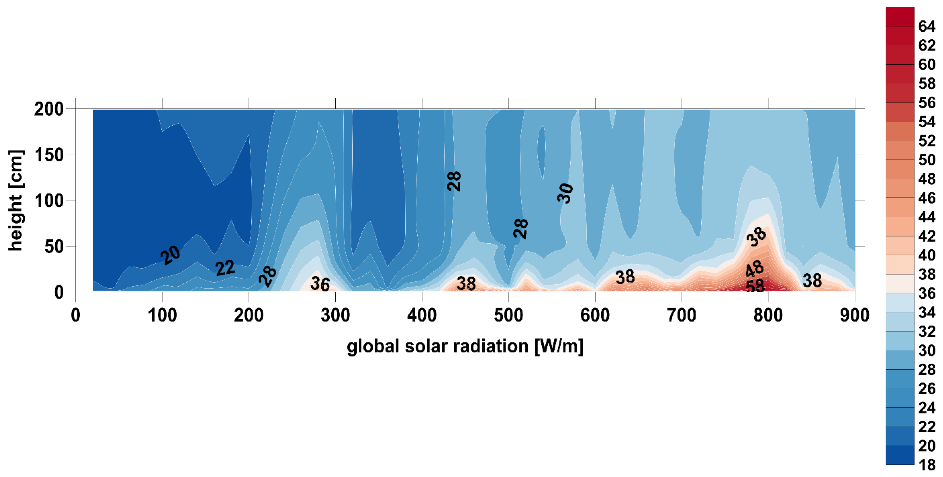
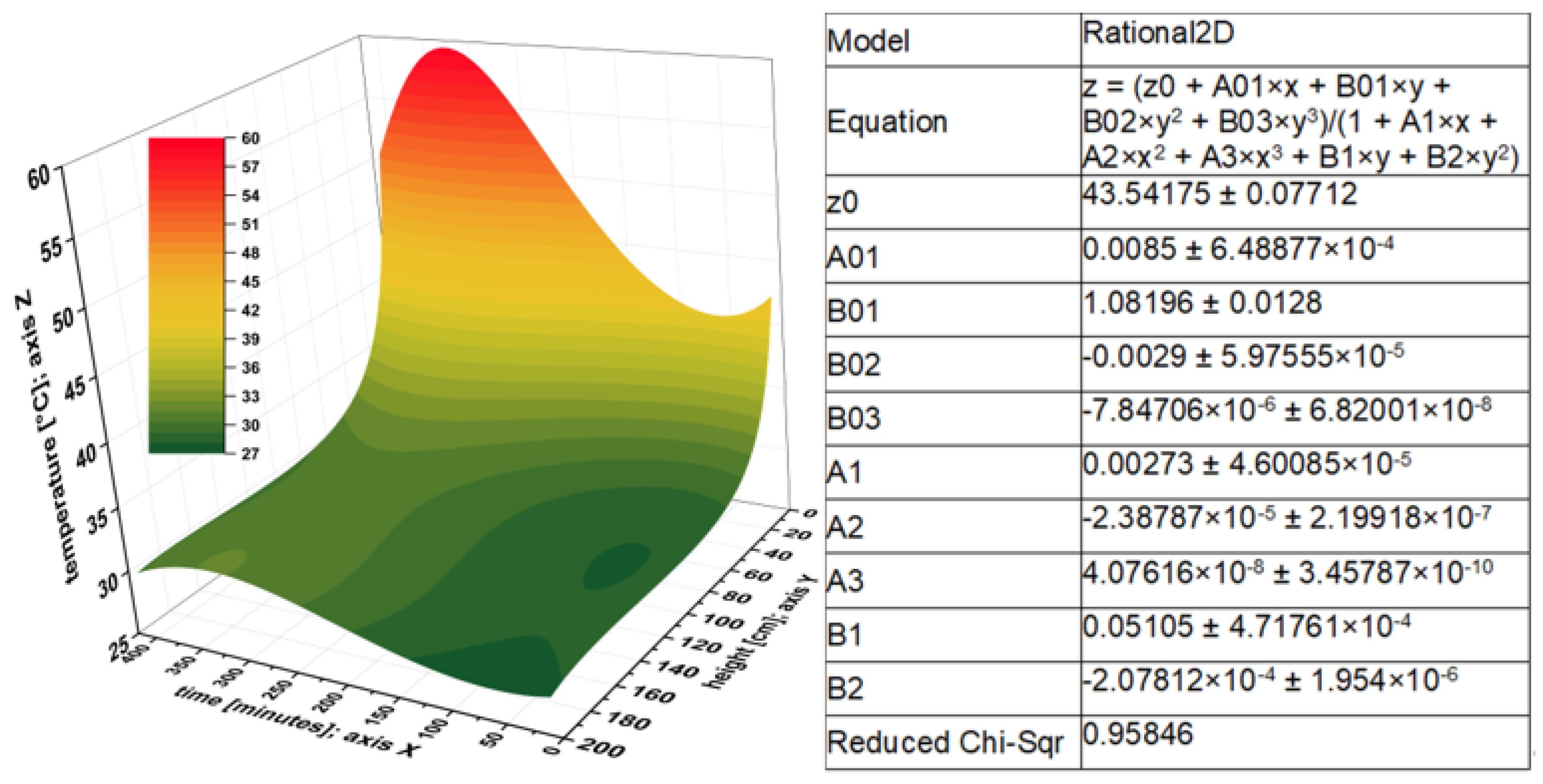
3.4. MUHI Evaluation: Surface Temperature and Temperature of Adjacent Air
4. Discussion
5. Conclusions
Author Contributions
Funding
Data Availability Statement
Conflicts of Interest
References
- Chuchma, F.; Středa, T.; Středová, H.; Rožnovský, J.; Vysoudil, M. Landscape Recreation and Bioclimatology–Hand in Hand. In Proceedings of the Conference on Public Recreation and Landscape Protection–with Nature Hand in Hand, Brno, Czech Republic, 2–4 May 2018; Fialová, J., Ed.; Mendel University in Brno: Brno, Czech Republic, 2018; pp. 232–237. [Google Scholar]
- Oke, T.R.; Johnson, G.T.; Steyn, D.G.; Watson, I.D. Simulation of surface urban heat islands under “ideal” conditions at night Part 2: Diagnosis of causation. Bound-Lay. Meteorol. 1991, 56, 339–358. [Google Scholar] [CrossRef]
- Matson, M.; McClain, E.P.; McGinnis, D.F., Jr.; Pritchard, J.A. Satellite detection of urban heat islands. Mon. Weather Rev. 1978, 106, 1725–1734. [Google Scholar] [CrossRef] [Green Version]
- Oke, T.R. The energetic basis of the urban heat island. Q. J. Roy. Meteor. Soc. 1982, 108, 1–24. [Google Scholar] [CrossRef]
- Howard, L. The Climate of London Deduced from Meteorological Observations, Made in the Metropolis, and at Various Places Around it; Harvey and Darton: London, UK, 1833; Volume 1–3. [Google Scholar]
- Tan, J.; Zheng, Y.; Song, G.; Kalkstein, L.S.; Kalkstein, A.J.; Tang, X. Heat wave impacts on mortality in Shanghai, 1998 and 2003. Int. J. Biometeorol. 2007, 51, 193–200. [Google Scholar] [CrossRef] [PubMed]
- Karl, T.; Knight, R. The 1995 Chicago heat wave: How likely is a recurrence? B. Am. Meteorol. Soc. 1997, 78, 1107–1120. [Google Scholar] [CrossRef] [Green Version]
- Dessai, S. Heat stress and mortality in Lisbon Part I. model construction and validation. Int. J. Biometeorol. 2002, 47, 6–12. [Google Scholar] [CrossRef]
- Schär, C.; Vidale, P.L.; Lüthi, D.; Frei, C.; Häberli, C.; Liniger, M.A.; Appenzeller, C. The role of increasing temperature variability in European summer heatwaves. Nature 2004, 427, 332–336. [Google Scholar] [CrossRef]
- Smargiassi, A.; Goldberg, M.S.; Plante, C.; Fournier, M.; Baudouin, Y.; Kosatsky, T. Variation of daily warm season mortality as a function of micro-urban heat islands. J. Epidemiol. Commun. Health 2009, 63, 659–664. [Google Scholar] [CrossRef]
- Arsenović, D.; Lehnert, M.; Fiedor, D.; Šimáček, P.; Středová, H.; Středa, T.; Savić, S. Heat-waves and mortality in Czech cities: A case study for the summers of 2015 and 2016. Geographica Pannonica 2019, 23, 162–172. [Google Scholar] [CrossRef] [Green Version]
- Meehl, G.A.; Tebaldi, C. More intense, More frequent, and longer lasting heat waves in the 21st century. Science 2004, 305, 994–997. [Google Scholar] [CrossRef] [Green Version]
- Zubidat, A.E.; Haim, A. Artificial light-at-night-a novel lifestyle risk factor for metabolic disorder and cancer morbidity. J. Basic Clin. Physiol. Pharmacol. 2017, 28, 295–313. [Google Scholar] [CrossRef]
- Kanianska, R.; Škvareninová, J.; Kaniansky, S. Landscape potential and light pollution as key factors for astrotourism development: A case study of a Slovak Upland region. Land 2020, 9, 374. [Google Scholar] [CrossRef]
- Škvareninová, J.; Tuhárska, M.; Škvarenina, J.; Babálová, D.; Slobodníková, L.; Slobodník, B.; Středová, H.; Minďáš, J. Effects of light pollution on tree phenology in the urban environment. Morav. Geogr. Rep. 2017, 25, 282–290. [Google Scholar] [CrossRef] [Green Version]
- Błażejczyk, K.; Epstein, Y.; Jendritzky, G.; Staiger, H.; Tinz, B. Comparison of UTCI to selected thermal indices. Int. J. Biometeorol. 2012, 56, 515–535. [Google Scholar] [CrossRef] [Green Version]
- Aniello, C.; Morgan, K.; Busbey, A.; Newland, L. Mapping micro-urban heat islands using LANDSAT TM and a GIS. Comput. Geosci. 1995, 21, 965–969. [Google Scholar] [CrossRef]
- Ekşi, M.; Uzun, A. Investigation of thermal benefits of an extensive green roof in Istanbul climate. Sci. Res. Essays 2013, 8, 623–632. [Google Scholar] [CrossRef] [Green Version]
- Stathopoulou, M.; Cartalis, C.; Keramitsoglou, I. Mapping micro-urban heat islands using NOAA/AVHRR images and CORINE Land Cover: An application to coastal cities of Greece. Int. J. Remote Sens. 2004, 25, 2301–2316. [Google Scholar] [CrossRef]
- Peng, S.; Piao, S.; Ciais, P.; Friedlingstein, P.; Ottle, C.; Bréon, F.M.; Nan, H.; Zhou, L.; Myneni, R.B. Surface urban heat island across 419 global big cities. Environ. Sci. Technol. 2012, 46, 696–703. [Google Scholar] [CrossRef]
- Geletič, J.; Lehnert, M.; Savić, S.; Milošević, D. Inter-/intra-zonal seasonal variability of the surface urban heat island based on local climate zones in three central European cities. Build. Environ. 2019, 156, 21–32. [Google Scholar] [CrossRef]
- Vysoudil, M.; Létal, A.; Pavelková, R. Thermal monitoring: Identification tool of natural disasters risks response to local climatic effects. In Proceedings of the 33rd International Symposium on Remote Sensing of Environment, ISRSE 2009, Stresa, Italy, 4–8 May 2009; code 97459. pp. 571–574. [Google Scholar]
- Ellefsen, R. Mapping and measuring buildings in the canopy boundary layer in ten U.S. cities. Energy Build. 1991, 16, 1025–1049. [Google Scholar] [CrossRef]
- Oke, T.R. Initial Guidance to Obtain Representative Meteorological Observations at Urban Sites. IOM Rep. 81, 2004, WMO/TD-No. 1250, 47p. Available online: www.wmo.int/pages/prog/www/IMOP/publications/IOM-81/IOM-81-UrbanMetObs.pdf (accessed on 4 March 2021).
- Stewart, I.D.; Oke, T.R. Local climate zones for urban temperature studies. B. Am. Meteorol. Soc. 2012, 93, 1879–1900. [Google Scholar] [CrossRef]
- Bechtel, B.; Daneke, C. Classification of local climate zones based on multiple earth observation data. IEEE J. Sel. Top. Appl. 2012, 5, 1191–1202. [Google Scholar] [CrossRef]
- Lelovics, E.; Unger, J.; Gál, T.; Gál, C.V. Design of an urban monitoring network based on Local Climate Zone mapping and temperature pattern modelling. Clim. Res. 2014, 60, 51–62. [Google Scholar] [CrossRef] [Green Version]
- Lehnert, M.; Savić, S.; Milošević, D.; Dunjić, J.; Geletič, J. Mapping local climate zones and their applications in European urban environments: A systematic literature review and future development trends. ISPRS Int. J. Geo-Inf. 2021, 10, 260. [Google Scholar] [CrossRef]
- Bechtel, B.; Alexander, P.J.; Böhner, J.; Ching, J.; Conrad, O.; Feddema, J.; Mills, G.; See, L.; Stewart, I. Mapping Local Climate Zones for a Worldwide Database of the Form and Function of Cities. ISPRS Int. J. Geo-Inf. 2015, 4, 199–219. [Google Scholar] [CrossRef] [Green Version]
- Bokwa, A.; Hajto, M.J.; Walawender, J.P.; Szymanowski, M. Influence of diversified relief on the urban heat island in the city of Kraków, Poland. Theor. Appl. Climatol. 2015, 122, 365–382. [Google Scholar] [CrossRef] [Green Version]
- Leconte, F.; Bouyer, J.; Claverie, R.; Pétrissans, M. Using local climate zone scheme for UHI assessment: Evaluation of the method using mobile measurements. Build. Environ. 2015, 83, 39–49. [Google Scholar] [CrossRef]
- Geletič, J.; Lehnert, M. GIS-based delineation of local climate zones: The case of medium-sized Central European cities. Morav. Geogr. Rep. 2016, 24, 2–12. [Google Scholar] [CrossRef] [Green Version]
- Geletič, J.; Lehnert, M.; Dobrovolný, P. Land surface temperature differences within local climate zones, based on two Central European cities. Remote Sens. 2016, 8, 788. [Google Scholar] [CrossRef] [Green Version]
- Yan, H.; Yang, S.; Guo, X.; Wu, F.; Wu, R.; Shao, F.; Bao, Z. Impact of land cover composition and structure on air temperature based on the local climate zone scheme in Hangzhou, China. Atmosphere 2021, 12, 936. [Google Scholar] [CrossRef]
- Cai, M.; Ren, C.; Xu, Y.; Lau, K.K.-L.; Wang, R. Investigating the relationship between local climate zone and land surface temperature using an improved WUDAPT methodology—A case study of Yangtze River delta, China. Urban Clim. 2018, 24, 485–502. [Google Scholar] [CrossRef]
- Rožnovský, J.; Litschmann, T.; Středová, H.; Středa, T.; Salaš, P.; Horká, M. Microclimate evaluation of the Hradec Králové city using HUMIDEX. Contrib. Geophys. Geod. 2017, 47, 231–246. [Google Scholar] [CrossRef] [Green Version]
- Köppen, W. Die Wärmezonen der Erde, nach der Dauer der heissen, gemässigten und kalten Zeit und nach der Wirkung der Wärme auf die organische Welt betrachtet. Meteorol. Z. 1884, 1, 215–226. [Google Scholar]
- European Environment Agency (EEA). Copernicus Programme. Urban Atlas 2018. Available online: https://land.copernicus.eu/local/urban-atlas (accessed on 5 April 2021).
- U.S. Geological Survey. EarthExplorer. Available online: https://earthexplorer.usgs.gov (accessed on 5 April 2021).
- Rozenstein, O.; Qin, Z.; Derimian, Y.; Karnieli, A. Derivation of land surface temperature for Landsat-8 TIRS using a split window algorithm. Sensors 2014, 14, 5768–5780. [Google Scholar] [CrossRef]
- Weng, Q. Thermal infrared remote sensing for urban climate and environmental studies: Methods, applications, and trends. ISPRS J. Photogramm. 2009, 64, 335–344. [Google Scholar] [CrossRef]
- Ward, J.H. Hierarchical grouping to optimize an objective function. J. Am. Stat. Assoc. 1963, 58, 236–244. [Google Scholar] [CrossRef]
- Murtagh, F.; Legendre, P. Ward’s hierarchical agglomerative clustering method: Which algorithms implement Ward’s criterion? J. Classif. 2014, 31, 274–295. [Google Scholar] [CrossRef] [Green Version]
- Kopp, J.; Frajer, J.; Novotná, M.; Preis, J.; Dolejš, M. Comparison of Ecohydrological and Climatological Zoning of the Cities: Case Study of the City of Pilsen. ISPRS Int. J. Geo-Inf. 2021, 10, 350. [Google Scholar] [CrossRef]
- Středa, T.; Středová, H.; Šedivá, I. Bioclimatic conditions for the recreationally important areas in the medium size city. In Public Recreation and Landscape Protection—with Man Hand in Hand? Krtiny, Czech Republic, 5–6 May 2014; Mendel University in Brno: Brno, Czech Republic, 2014; pp. 47–51. [Google Scholar]
- Středová, H.; Středa, T.; Litschmann, T. Smart tools of urban climate evaluation for smart spatial planning. Morav. Geogr. Rep. 2015, 23, 47–57. [Google Scholar] [CrossRef] [Green Version]
- Lehnert, M.; Geletič, J.; Husák, J.; Vysoudil, M. Urban field classification by “local climate zones” in a medium-sized Central European city: The case of Olomouc (Czech Republic). Theor. Appl. Climatol. 2015, 122, 531–541. [Google Scholar] [CrossRef]
- Oxoli, D.; Ronchetti, G.; Minghini, M.; Molinari, M.E.; Lotfian, M.; Sona, G.; Brovelli, M.A. Measuring urban land cover influence on air temperature through multiple geo-data—The case of Milan, Italy. ISPRS Int. J. Geo-Inf. 2018, 7, 421. [Google Scholar] [CrossRef] [Green Version]
- Geletič, J.; Vysoudil, M. Analysis of surface temperatures in urban and suburban landscapes from satellite thermal images: A case study of Olomouc and its environs, Czech Republic. Morav. Geogr. Rep. 2012, 20, 2–15. [Google Scholar]
- Zare, S.; Hasheminejad, N.; Shirvan, H.E.; Hemmatjo, R.; Sarebanzadeh, K.; Ahmadi, S. Comparing Universal Thermal Climate Index (UTCI) with selected thermal indices/environmental parameters during 12 months of the year. Weather. Clim. Extrem. 2018, 19, 49–57. [Google Scholar] [CrossRef]
- Geletič, J.; Lehnert, M.; Krč, P.; Resler, J.; Krayenhoff, E.S. High-resolution modelling of thermal exposure during a hot spell: A case study using PALM-4U in Prague, Czech Republic. Atmosphere 2021, 12, 175. [Google Scholar] [CrossRef]
- Geletič, J.; Lehnert, M.; Jurek, M. Spatiotemporal variability of air temperature during a heat wave in real and modified landcover conditions: Prague and Brno (Czech Republic). Urban Clim. 2020, 31, 100588. [Google Scholar] [CrossRef]
- Lehnert, M.; Brabec, M.; Jurek, M.; Tokar, V.; Geletič, J. The role of blue and green infrastructure in thermal sensation in public urban areas: A case study of summer days in four Czech cities. Sustain. Cities Soc. 2021, 66, 102683. [Google Scholar] [CrossRef]
- Lehnert, M.; Tokar, V.; Jurek, M.; Geletič, J. Summer thermal comfort in Czech cities: Measured effects of blue and green features in city centres. Int. J. Biometeorol. 2021, 65, 1277–1289. [Google Scholar] [CrossRef]
- Vaníčková, M.; Stehnová, E.; Středová, H. Long-term development and prediction of climate extremity and heat waves occurrence: Case study for agricultural land. Contrib. Geophys. Geod. 2017, 47, 247–260. [Google Scholar] [CrossRef] [Green Version]
- Středová, H.; Středa, T. Agroclimatic conditions of the Czech Republic—Development and influence on agricultural production. In Seed and Seedlings, Prague, Czech Republic; Pazderu, K., Ed.; Czech University of Life Sciences: Prague, Czech Republic, 2015; pp. 22–27. [Google Scholar]
- Lukasová, V.; Vido, J.; Škvareninová, J.; Bičárová, S.; Hlavatá, H.; Borsányi, P.; Škvarenina, J. Autumn phenological response of European beech to summer drought and heat. Water 2020, 12, 2610. [Google Scholar] [CrossRef]
- Středa, T.; Středová, H.; Rožnovský, J. Orchards microclimatic specifics. In Bioclimate: Source and Limit of Social Development, Topolčianky, Slovakia; Slovak University of Agriculture: Nitra, Slovakia, 2011; pp. 132–133. [Google Scholar]
- Středa, T.; Cerkal, R.; Hájková, L.; Chuchma, F.; Khel, T.; Klimešová, J. GIS application in abiotic risks regionalization for spring barley. Contrib. Geophys. Geod. 2020, 50, 49–60. [Google Scholar] [CrossRef]
- Litschmann, T.; Středa, T. Surface temperature of plant tissues. Which method of air temperature measurement fits best? Contrib. Geophys. Geod. 2019, 49, 11–23. [Google Scholar] [CrossRef] [Green Version]
- Středa, T.; Středová, H.; Chuchma, F.; Kučera, J.; Rožnovský, J. Smart method of agricultural drought regionalization: A winter wheat case study. Contrib. Geophys. Geod. 2019, 49, 25–36. [Google Scholar] [CrossRef] [Green Version]
- Středová, H.; Fukalová, P.; Chuchma, F.; Středa, T. A complex method for estimation of multiple abiotic hazards in forest ecosystems. Water 2020, 12, 2872. [Google Scholar] [CrossRef]
- Středová, H.; Klimešová, J.; Středa, T.; Fukalová, P. Could the directly measured data of transpiration be replaced by model outputs? Contrib. Geophys. Geod. 2020, 50, 33–47. [Google Scholar] [CrossRef]
- Babálová, D.; Škvareninová, J.; Fazekaš, J.; Vyskot, I. The dynamics of the phenological development of four woody species in South-West and Central Slovakia. Sustainability 2018, 10, 1497. [Google Scholar] [CrossRef] [Green Version]
- Středa, T.; Středová, H.; Rožnovský, J. Microclimate of tourist attractive areas of Brno City. In Public Recreation and Landscape Protection—Hand in Hand? Brno, Czech Republic, 4–6 May 2011; Fialová, J., Ed.; Mendel University in Brno: Brno, Czech Republic, 2011; pp. 78–84. [Google Scholar]


| LCZ Class | 2 | 3 | 4 | 5 | 6 | 8 | 9 | 10 | A | B | D | E | G | SUM |
|---|---|---|---|---|---|---|---|---|---|---|---|---|---|---|
| Area (ha) | 61 | 47 | 28 | 305 | 683 | 272 | 683 | 33 | 1838 | 577 | 4940 | 194 | 232 | 9893 |
| Area (%) | 0.6 | 0.5 | 0.3 | 3.1 | 6.9 | 2.7 | 6.9 | 0.3 | 18.6 | 5.8 | 49.9 | 2.0 | 2.3 | 100 |
| LANDSAT Scene Identifier | Date | Time (UTC) | Scene Cloud Cover | Solar Elevation | Solar Azimuth |
|---|---|---|---|---|---|
| LC81900252013169LGN01 | 2013/06/18 | 09:46:30 | 0.15 | 60.126 | 147.931 |
| LC81910252013208LGN01 | 2013/07/27 | 09:52:42 | 1.65 | 55.684 | 148.656 |
| Location of Measurement | Label | Brief Characteristics of the Environment | LCZ [25] Classification in [46] | LCZ Class by [32] |
|---|---|---|---|---|
| Industrial zone 50°11′43.159″ N, 15°51′18.336″ E | 1 | significant proportion of horizontal concrete and asphalt surfaces, partial grassland, sunlit spaces all day | LCZ 8B (large low-rise with scattered trees) | 8 |
| City park 50°12′21.884″ N, 15°49′31.925″ E | 2 | woody vegetation in the city center, grass cover, full shade, near the confluence of two major rivers | LCZ B (scattered trees land cover type) | B |
| Suburban forest 50°10′39.974″ N, 15°54′14.036″ E | 3 | middle-aged, predominantly coniferous forest, shaded by trees (except in the afternoon), absence of significant artificial surfaces | LCZ A (dense trees land cover type) | A |
| Historic city center 50°12′39.493″ N, 15°49′55.767″ E | 4 | the historical part of the city center, enclosed area (courtyard) with vertical surfaces and limited air flow, artificial solid surfaces, insolation from morning until afternoon | LCZ 32 (compact low-rise with mid-rise built type) | 2 |
| Urban residential zone 50°12′52.516″ N, 15°49′32.781″ E | 5 | location surrounded by residential buildings five stories high, woody and shrubby vegetation in the immediate vicinity of the measurement location, grass cover, small summer swimming pool, partially sunlit afternoons | LCZ 2B (compact mid-rise with scattered trees) | 2 |
| Reference climatological location 50°13′21.367″ N, 15°47′15.969″ E | 6 | situated on the outskirts of suburban housing development, woody plants nearby, horizontal artificial surfaces nearby, located according to the principles of meteorological station establishment, the AT sensors are placed in a radiation shield | LCZ 9 (sparsely built–built type) | 9 |
| Reference climatological location 50°10′39.01″ N, 15°50′18.98″ E | 7 | situated on the outskirts of suburban housing development, woody plants nearby, significant areas of grass cover in the vicinity, located according to the principles of meteorological station establishment, the AT sensors are placed in a radiation shield | LCZ 9 (sparsely built–built type) | D |
| LCZ Class | |||||||||||||||
|---|---|---|---|---|---|---|---|---|---|---|---|---|---|---|---|
| 2 | 3 | 4 | 5 | 6 | 8 | 9 | 10 | A | B | D | E | G | AVG | ||
| 18 June | Average | 43.7 | 43.0 | 41.1 | 42.0 | 40.8 | 42.7 | 39.2 | 45.7 | 34.2 | 37.7 | 35.2 | 40.6 | 33.3 | 39.9 |
| Mean max | 45.2 | 44.5 | 42.1 | 43.4 | 42.2 | 44.6 | 40.5 | 47.6 | 35.1 | 39.0 | 36.4 | 42.3 | 34.9 | 41.4 | |
| Mean min | 42.0 | 41.3 | 40.0 | 40.6 | 39.4 | 40.9 | 37.9 | 43.8 | 33.3 | 36.3 | 34.0 | 38.9 | 31.9 | 38.5 | |
| Abs max | 49.2 | 50.0 | 45.1 | 50.8 | 55.4 | 56.3 | 54.8 | 54.8 | 50.9 | 52.9 | 55.5 | 50.4 | 49.4 | 51.9 | |
| Abs min | 32.2 | 31.2 | 34.2 | 29.9 | 29.6 | 29.6 | 29.0 | 34.6 | 29.5 | 28.5 | 27.7 | 30.2 | 28.0 | 30.3 | |
| 27 July | Average | 45.7 | 45.6 | 45.3 | 45.1 | 44.0 | 45.6 | 42.8 | 47.8 | 36.0 | 41.6 | 40.3 | 44.0 | 37.1 | 43.1 |
| Mean max | 47.0 | 46.9 | 46.0 | 46.4 | 45.3 | 47.4 | 44.1 | 49.5 | 37.0 | 43.0 | 41.6 | 45.5 | 38.9 | 44.5 | |
| Mean min | 44.2 | 44.2 | 44.5 | 43.8 | 42.8 | 43.9 | 41.6 | 46.3 | 35.0 | 40.3 | 39.0 | 42.6 | 35.4 | 41.8 | |
| Abs max | 51.2 | 51.0 | 49.4 | 54.9 | 57.6 | 57.7 | 55.6 | 57.1 | 53.3 | 54.5 | 57.9 | 54.0 | 56.3 | 54.7 | |
| Abs min | 38.1 | 37.0 | 40.4 | 34.1 | 33.4 | 34.7 | 32.8 | 37.9 | 31.9 | 32.6 | 31.0 | 34.8 | 30.5 | 34.6 | |
| Location | LCZ Class by [32] | Avg | Median | Min | Max | Range | St. Dev. |
|---|---|---|---|---|---|---|---|
| 1 (industrial zone) | 8 | 11.0 | 10.8 | −22.6 | 39.5 | 62.2 | 9.2 |
| 2 (city park) | B | 10.6 | 11.0 | −19.1 | 35.7 | 54.8 | 8.5 |
| 3 (suburban forest) | A | 9.7 | 9.6 | −22.5 | 37.3 | 59.7 | 8.8 |
| 4 (city center) | 2 | 12.0 | 12.1 | −17.7 | 41.1 | 58.8 | 9.3 |
| 5 (urban residential zone) | 2 | 11.0 | 11.2 | −18.6 | 36.2 | 54.8 | 8.7 |
| 6 (reference climatological location) | 9 | 10.4 | 10.6 | −20.1 | 36.8 | 56.9 | 8.8 |
| 7 (reference climatological location) | D | 10.7 | 10.8 | −18.4 | 37.2 | 55.6 | 8.7 |
| 18 June | Average LST | 43.7 | 42.7 | 39.2 | 37.7 | 35.2 | 34.2 |
| LCZ class | 2 | 8 | 9 | B | D | A | |
| AT | 32.5 | 32.4 | 29.7 | 29.0 | 28.8 | 28.8 | |
| LCZ class | 8 | 2 | 9 | D | B | A | |
| 27 July | Average LST | 45.7 | 45.6 | 42.8 | 41.6 | 40.3 | 36.0 |
| LCZ class | 2 | 8 | 9 | B | D | A | |
| AT | 35.9 | 35.8 | 32.5 | 32.3 | 31.0 | 30.9 | |
| LCZ class | 8 | 2 | 9 | D | B | A |
Publisher’s Note: MDPI stays neutral with regard to jurisdictional claims in published maps and institutional affiliations. |
© 2021 by the authors. Licensee MDPI, Basel, Switzerland. This article is an open access article distributed under the terms and conditions of the Creative Commons Attribution (CC BY) license (https://creativecommons.org/licenses/by/4.0/).
Share and Cite
Středová, H.; Chuchma, F.; Rožnovský, J.; Středa, T. Local Climate Zones, Land Surface Temperature and Air Temperature Interactions: Case Study of Hradec Králové, the Czech Republic. ISPRS Int. J. Geo-Inf. 2021, 10, 704. https://doi.org/10.3390/ijgi10100704
Středová H, Chuchma F, Rožnovský J, Středa T. Local Climate Zones, Land Surface Temperature and Air Temperature Interactions: Case Study of Hradec Králové, the Czech Republic. ISPRS International Journal of Geo-Information. 2021; 10(10):704. https://doi.org/10.3390/ijgi10100704
Chicago/Turabian StyleStředová, Hana, Filip Chuchma, Jaroslav Rožnovský, and Tomáš Středa. 2021. "Local Climate Zones, Land Surface Temperature and Air Temperature Interactions: Case Study of Hradec Králové, the Czech Republic" ISPRS International Journal of Geo-Information 10, no. 10: 704. https://doi.org/10.3390/ijgi10100704
APA StyleStředová, H., Chuchma, F., Rožnovský, J., & Středa, T. (2021). Local Climate Zones, Land Surface Temperature and Air Temperature Interactions: Case Study of Hradec Králové, the Czech Republic. ISPRS International Journal of Geo-Information, 10(10), 704. https://doi.org/10.3390/ijgi10100704