Abstract
This paper analyzes the relationships between the peri-urbanization process in the surroundings of cities and the increase in the synergistic dangers of flooding and water erosion. An analysis and an evaluation of the conditions causing the flooding in peri-urban basins are carried out, comparing the conditions before and after the peri-urbanization process. For this purpose, a diachronic analysis of the morphological and functional conditions of the territory that conditions flooding and associated dangers is provided. The conditions for the generation of runoff, the incorporation of solids into the flood flow, and the characteristics of urban planning are evaluated in 1956 (date before the peri-urbanization process) and 2010 (the peak of the urbanization process in the area) in order to analyze the changes in the land use model and their consequences on the increase in risk. The study is applied to four river basins (44 km2 in total) with varied land use models, in order to collect representative scenarios of the peri-urban coastal basins of the Spanish Mediterranean region. The results show that the risk factors that undergo the most significant changes are the runoff threshold, the vegetation cover, and the soil structure. It is concluded that peri-urbanization constitutes a territorial risk-causing process, and attention is drawn to the convenience of going beyond the sectoral approach in the study of hazards, coming to understand them as a multi-hazard process in which causes have a direct relationship with the underlying territorial model.
1. Introduction
The peri-urban areas (processes of dispersive urban growth that create hybrid landscapes of fragmented urban and rural characteristics) of the Spanish Mediterranean coast have the highest concentration of population and settlement in the entire Iberian Peninsula, so it is important to pay attention to this area. They are the preferred area for the expansion of urbanization, with strong differences occurring at a significantly faster rate than in other European countries [1]. Floods and associated hazards on the Mediterranean coast, and more specifically in the urban–rural interface, are responsible for a high percentage of all economic and human life losses that all-natural risks are causing in Spain in the last years [2]. They are the preferential flow paths of flash floods, which are increasingly difficult to manage with the usual flood control instruments [3].
The V IPCC Report on Climate Change predicts the hazard increase in various associated risks for the Mediterranean environment and coastal areas, such as wildfires, drought, soil erosion, floods, mass movements, and coastal flooding processes, as well as erosion associated to storms and sea level rise. The natural hazard increase will be accompanied by the spreading of urbanization and the consequent activation of processes that induce hazard, by the increase in population, and by the number of assets exposed to the impact. For these reasons, the coastal peri-urban basins will constitute the most prominent risk scenarios in the near future.
The urban–rural interface or border areas, such as the peri-urban and/or the coastline, are very dynamic spaces for changes in land use. Simultaneously, they are scenarios of change and conflict [4,5] where intervention is needed [6,7,8,9], and they are very fragile from a risk point of view [10,11,12,13]. In turn, they are those that provide opportunities for preventive management, since they are an ideal spatial framework for the management of solutions [14,15]. From the risk point of view, the basins of peri-urban environments represent the concept of a place of risk and a region of risk [11,16,17,18,19], since they have morphological and functional characteristics that boost and complicate risk processes. Perles and Mérida [15] identify which specific aspects of the peri-urban territorial pattern boost risk generation mechanisms and justify why it is essential to apply a territorial, spatial, and integrated approach to manage them effectively.
Since the Kobe Conference in 2005, several authors and international institutions have highlighted this fact: the need to apply a territorial and integrated approach to the analysis and management of risk. Following this approach, Perles [20] proposes the need to identify spatial units characterized by the territorial risk pattern as management units.
The spatial approach to risk as an analysis and management strategy involves two issues: treating the concurrent risks as associated processes (multi-risk), and overcoming the dichotomy between a biophysical environment, which is a hazard source, and a human environment, which deals with hazards. In a territorial risk approach, the spatial risk pattern is composed of natural and artificial factors, whereas anthropic actions can enhance both hazard and exposure, depending on their position. Urban planning focused on risk management from a territorial point of view not only must control the urbanization process as responsible for increasing exposure to risk, but also as a hazard-inducing cause. Fathianpour et al. [21], among others, argue that human-made hazards, in conjunction with natural hazards, are more destructive. When risks are observed in anthropized areas, or in urban–rural interface zones, the transfer of matter and energy of the processes is very changeable and complex, so it is necessary to adapt the hazard methodologies. The peri-urban area is, par excellence, the growth area of the city where human intervention is more evident.
Some works have addressed the role of the urbanization process as an anthropic action that increases risk. For example, those referring to the inductive role of infrastructures [22,23]. Giordan et al. [24] describe this phenomenon in peri-urban areas.
In the study area, some authors have analyzed the influence of the real estate bubble over the increasing human exposure to flooding [24,25,26,27], whereas Villar and Ojeda [28] focus on the coastal strip. However, there are fewer studies of the role of humans’ magnifications of hazards.
In 2008, in the report Maps of Natural Risks in Territorial and Urban Planning, published by the College of Geologists, Ortega [29] included a systematization of anthropic actions with influence in flooding and floods mapping. However, this procedure has not been used at a planning scale. Perles [20] provides a classification of the main actions on the territory that can induce flood hazard and other associated risks, with the aim of considering them as inputs in risk mapping. Some studies address the incidence of urbanization in certain hazard processes. Segura [30], Segura and Sanchis [31], or Baena et al. [32] observe the modifications that the occupation of channels produce in floods at heavily urbanized spaces. Romeu and Segura [33], Pascual and López [34], and Gallegos and Perles [35] describe the consequences of changes in land uses on flooding, while Caballero [36] focuses on the consequences of soil waterproofing. The research by Conesa, García, and Pérez [37] and Conesa and García [38,39] analyzes the interference produced by infrastructures (roads, bridges, culverts), in the dynamics of erosion, sedimentation, and flooding. Following this approach, an interesting work is provided by Cantarero [40], which assesses the potential of alteration of each anthropic activity in urban areas according to three aspects: as a source of extraordinary runoff (e.g., compaction, asphalt, logging), as a source of debris (e.g., plant debris, urban furniture, cars) and as a source of water flow blockages. The work also calculates the potential damage of each activity due to its position in the flood sequence. The studies by Gallegos [41,42] also follow a similar approach, since the author insists on the key role of anthropic inducement in the Mediterranean flood model, especially in basins located in peri-urban environments, such as most of the ones classified as ARPis (Potential Risk Areas to Severe Flooding). Grimalt-Gelabert et al. [43] indicate how infrastructures (i.e., artificial concrete canals, narrow-stem bridges, etc.) can play a role in inducing flooding in many cases.
In order to be able to include hazard as a factor in the evaluation and mapping models, a further step in the study of the anthropic hazard inducement is to quantitatively estimate the incidence of human activities on hazard. Ruíz, Romero, and Belmonte [44] measure an alarming rate of erosion in soils mobilized by urbanization (479 Tm/ha/year), which is higher than those obtained by Martin Moreno et al. [45] in soils mobilized by mining (318 Mg/ha/year).
As aforementioned, the proposed territorial risk approach involves analyzing several types of hazards that occur in the peri-urban area, that is, a multi-hazard approach. In a rhexistasic Mediterranean environment, propitious to flash floods, the main chain of associated hazards links water erosion, gravitational movements, and dragging solids into the flood flow. All these hazards are highly conditioned by urban development, and they are especially dynamic in peri-urban areas. Díez-Herrero and Garrote [45] point out how the studies of multiple risks and the interactions between the risk of flooding and other types of natural hazards are one of the lines in the study of flood risk. Nevertheless, it is striking how this issue is not being considered in most of the flood maps with planning purposes in Spain, despite being evident that the predicted degree of hazard and the consequences of floods are underestimated if the solid load of the flood is not considered [46].
Multi-hazard analysis is a growing line of research, although it is limited, so far, due to its methodological complexity. Authors such as Cutter et al. [47], Carpignano et al. [48], Cozzani et al. [49], Delmonaco et al. [50], and Baoyin [51] have provided a generalist and/or methodological view on the subject. Kappes et al. [52], Gill and Malamud [53], or Gallina et al. [54] use matrices to connect the possible chains of interrelation of multiple hazards. Authors such as Pelling [55] use the multi-risk approach to analyze specific territorial models, such as that of coastal mega-cities. Hart and Hawke [56] apply the multi-hazard approach to improve the study of floods.
In the Spanish context, most of the studies are based on monitoring cases at a very detailed scale [57,58,59], so, in practice, they cannot be applied at a planning scale. Bout et al. [60] or Kumbier et al. [61] highlight this as a common problem in multi-hazard approaches, stating that a study case based on empirical understanding might be applicable just to a given scenario of a specific event.
At a larger scale, Perles and Cantarero [62] provide a proposal for mapping hazards spatially and temporally connected. Cantarero [40], Gallegos [41], and Gallegos and Perles [63] propose methodological strategies to assess how hazards associated with the flooding process affect the contribution of solid load to the flow. Based on this idea, they try to deduce the consequences of the increase in hazard level and the growth of the flooded area. Perles et al. [64] also analyze the behavior of several types of associated risks (e.g., mass movement, erosion, flooding) when they take place in the surroundings of roads.
Tilloy observed that from the first [65] to the most recent attempts [52,65,66], the difficulty of chain analysis of hazards is in the quantification of the relationships between hazards, since single processes are generally quantified in different units [67]. Quantification on an applicable scale, useful for urban planning, is still a challenge to be solved in order to assess the real relevance of the flood hazard when it occurs in environments with a territorial pattern as complex as that of coastal peri-urban basins.
Based on the aforementioned studies and taking into account the spatial relationship between risk production and the land use model as an initial approach, this work analyzes the incidence of peri-urbanization processes in the risk of flooding and the associated water erosion in peri-urban areas. The general objective of the research is to analyze how the peri-urbanization has produced an increase in the flood hazard and associated risks, regardless of the increase in the exposure and vulnerability of the territory. The close relation between spatial occupation and hazard inducement, as well as the joint development of erosion hazards, the addition of solids to flow, and the changes in the hydrological conditions of the flood and the expansion of the sheet of water are quantitatively and qualitatively evaluated.
The specific aims of the research are to identify and quantify the land uses that are responsible for the increase in flood hazard levels and associated hazards in the peri-urban coastal basins of the Mediterranean environment. This entails characterizing the way in which the flooding and associated risks affect, on the one hand, the natural conditions inherent to the Mediterranean environment (i.e., torrential rainfall, high potential erosion, morphology, hydraulic system), and, on the other, the model of the urban management of the floodable zone. In order to address the objectives, it is proposed to carry out a diachronic analysis of the behavior of flood hazard and erosion hazard in four basins between 1956 (before urbanization) and 2010 (after urbanization). The comparison of both situations allows identifying the level of affection and how the peri-urbanization affects flooding.
2. Study Areas
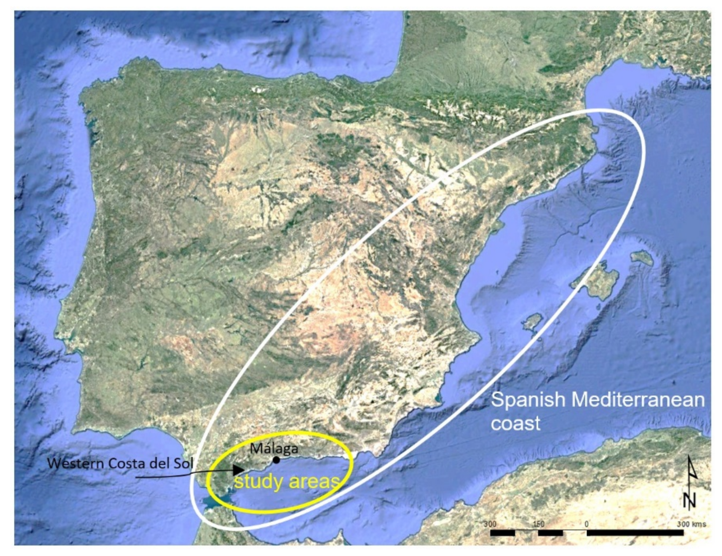
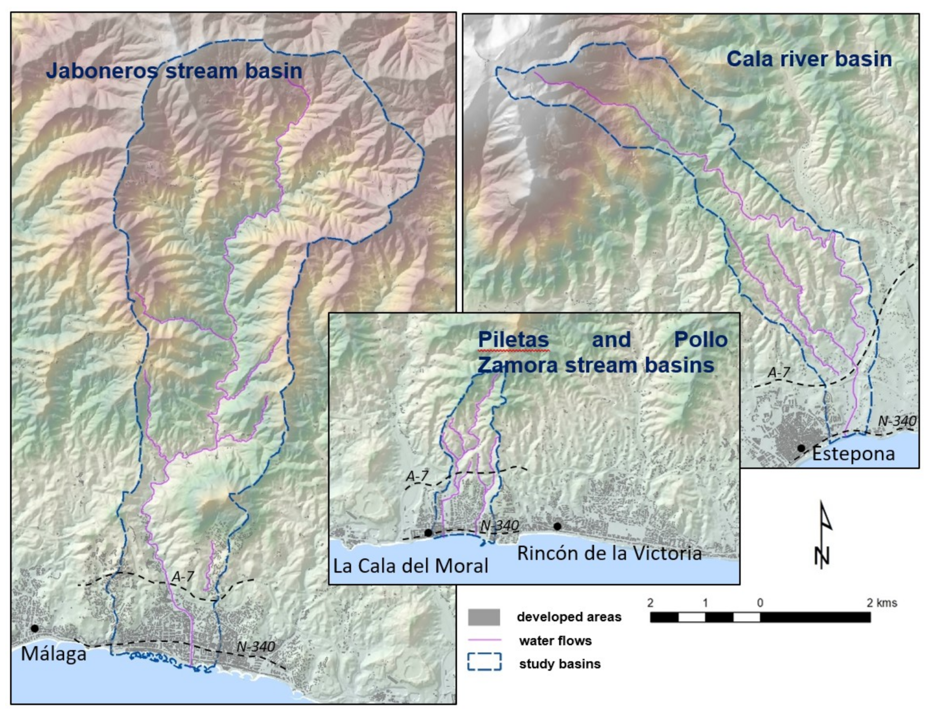
Four study areas have been selected (Figure 1 and Figure 2) in order to collect the characteristics and diversity of the basins located in peri-urban areas of the Spanish Mediterranean coast. Thus, it is intended to represent the main urban and territorial models of this region of risk. The analyses have been performed at a basin scale, in order to evaluate the physical processes that take place in them. The selected basins are the Cala River basin (Estepona), the Jaboneros stream basin (Málaga), the Piletas stream basin, and the Pollo Zamora stream basin (Rincón de la Victoria). All of them are located in the province of Málaga in southern Spain (Figure 1).

Figure 1.
Location of the study areas in the Spanish Mediterranean coast.

Figure 2.
Study areas.
The Cala River basin, in the heart of the western Costa del Sol, has been selected as an example of a tourist area developed in the peri-urban area of the coastal cities, next to the foothills and the sea. The area is strongly affected by anthropic activities, which are usually disorganized and without urban planning. Numerous second regular residence homes are scattered in the area, and agricultural plots are located at the southernmost tip, between the A7 highway and the coast.
The Jaboneros stream is located in the eastern part of Málaga township. The lowest part of the Jaboneros stream basin is located in the surroundings of Málaga City, and it is an interface urban/peri-urban model. It includes forest and recreational areas, as well as agricultural plots in the northern sector, which is mostly rural.
Finally, the small and strongly anthropized basins of the Piletas and Pollo Zamora streams, next to each other, are located at the western part of the Rincón de la Victoria township. From an urban perspective, they are characterized by a multi-family second residence model. They are built following a suburban model of moderate density. They represent the development of interface areas that have enhanced the metropolitan growth of the cities in the Mediterranean coast. However, there are also recent houses used as first residence by people that use the A7 highway for their daily commute to the city; this is a daily pendular movement.
One of the key characteristics of the patterns analyzed in this work is the complex mix of land uses and urban patterns within all the basins, which tend to be disorganized and out of planning. In this way, in each of the basins, first and second regular residences are complemented with residential, tourist, or even agricultural areas, in use or abandoned, multi-family or single-family buildings, with a concentrated and/or scattered distribution. Due to their functional and morphological diversity, the dynamism of their changes, and their links with the urban agglomeration, they follow an evident interface development pattern [68].
The selected basins clearly show the varied characteristics of the Mediterranean interface areas, the mix of land uses, the abundance of interstitial spaces, and the effect of the different stages of the urban development process. The aim is to include the main problems of this risk area in the hazard analysis.
In each of these basins, a digital map database has been developed and integrated into a geographic information system (GIS), which includes both the physical aspects and information about the determining factors of flooding and associated risks. The database also includes basic territorial elements, such as infrastructures, settlements, and historic heritage, as well as information about municipal and regional planning. Likewise, hydrological, hydraulic, and potential soil erosion and mass movement analyses have been carried out for each basin.
Regarding the geomorphological pattern, all the basins have a rugged topography with enclosed channels and gullying slopes caused by rhexistasy due to intense deforestation for hundreds of years. Another important topographic characteristic is the proximity of the mountainous to the sea, so the basin is very close to the coast, the slopes are steep, and the littoral plain is narrow. These are rapid drainage routes, as indicated not only by the geomorphology of the channels but also by the presence of sediments, sometimes deposited as alluvial fans. The morphology and hydraulic functioning of the channels depend on conditioning factors, but the patterns vary according to the section of the basin. The study area includes ephemeral rivers, streams located in enclosed rocky substrates (canyons), streams located in open rocky substrates, and streams located in alluvial fans. Generally, once flows are activated by a storm, streams can become braided rivers. When water levels are low or moderate, rivers form meanders, but with rising levels, rivers can become straight and braided, until the braids coalesce. Hazard levels increase, as energy cannot be easily dissipated. Another characteristic of the study areas is the presence of fans, which appear between the canyons at the upper and middle sections and the flood plains, where the channel is no longer enclosed. They usually indicate areas of greater hazard, where sudden changes in the hydraulic behavior of the river will foreseeably occur.
3. Materials and Methods
The basis of the research is the diachronic analysis of the conditions that produce hazard of flood and other associated hazards in two moments: before the study areas were affected by peri-urbanization processes (1956) and in the peak moment of urban expansion in the area (2010), during the so-called real estate bubble in Spain. These dates follow the aim of assessing the morphological and functional changes of the territory caused by the peri-urbanization process and the degree of alteration that they generate in the determining hazard and vulnerability factors to flooding and associated risks. The use of data prior to and after the peri-urbanization process allows identifying the risk behavior in the basins. Although the peri-urbanization process was not simultaneous in all the basins, it was always later than 1956, so the transformations of the risk conditioning factors must be observed in the study period (1956–2010).
The selected temporal milestones for the comparison are also based on the existing cartographic information, whose limit is set by the 1956/57 series of orthophotographs, and the information from the reviews of the municipal urban planning provided by the townships of the study area in 2010.
3.1. Characterization of Factors Causing Runoff and Solid Load in the Flow
In order to know the functioning of the runoff processes and the addition of solid load into the flood flow, both before and after the urbanization process, the following methodological steps have been undertaken:
- -
- Development of a hydrological–hydraulic study in each basin for 1956 and 2010, which provides maps of flooded areas. The hydrological–hydraulic studies have been carried out using the rational method modified by Temez to obtain flow rates and the HEC-RAS model for the hydraulic results.
- -
- Diachronic calculation of solid sediment production due to soil erosion in the basins, by applying the RUSLE (Revised Universal Soil Equation) and MUSLE (Modified Universal Soil Equation), which both calculate potential erosion. RUSLE calculates the annual tons of estimated soil loss, whereas MUSLE calculates tons of soil loss in a rainfall event, which in this work has been a 500-year return period event.
3.2. Evolution of Land Uses and Urban Pattern
Knowing the territorial evolution of the basins allows us to analyze how the human environment has influenced the anthropic inducement of natural risks. To this end, an evolutionary analysis of land uses has been carried out between 1956 and 2010. This analysis has been supported by the information provided by several photogrammetric flights and orthophotographs available at the Department of the Environment of the Junta de Andalucía, as well as thanks to the information provided by the townships. This information is obtained from the cartography used in the municipal urban planning, relating both to aspects of the physical environment (Digital Terrain Models) and to the regulatory framework (land classifications and soil qualifications, risk processes assessment, environmental units, or environmental protections). Regarding the photogrammetric flights, the first one dates from 1956/57, which is an optimal date to start the analysis, since urban developmentalism was not initiated in Spain. From here on, the other selected dates are 1977, 1999, 2003, and 2010. In all of them, maps of land use and urban use of the basins have been created. As a result, we have information on anthropic activities in the territory.
4. Results
Between 1956 and 2010, the main change originated by the peri-urbanization process in the basins is the runoff threshold and, consequently, the extension of the floodable surface. Likewise, there are also changes in the vegetation cover and the structure of the soils, and consequently in the contribution of solid load to the flow.
4.1. Runoff Generation and Floodplain in 2010
The previous step to any of the hydraulic studies carried out has been done to statistically obtain the maximum expected daily rainfall in each basin for the 500-year return period considered, following the book ‘Maximum daily rains in Spain’ by the Ministry of Public Works. The results by basin are as follows (Table 1).

Table 1.
Maximum daily precipitation for a 500-year return period.
The fact that values between 238 and 266 L/m2 are obtained for the 500-year return period show the rainfall intensity of the area.
The runoff threshold is also relevant, which indicates the precipitation needed in L/m2 to produce runoff (Table 2).
Table 2.
Precipitation–runoff transformation data in the basins for a 500-year return period in 2010.
According to these results, in 2010, the average runoff threshold in the study areas was around 50 L/m2. However, in the Piletas-Pollo Zamora basins, the runoff retention capacity decreased to 6 L/m2, which means that almost any rainfall event begins to generate runoff from the first minutes. As a reference, for the province of Málaga, and according to the data, the mean runoff threshold is 70.5 L/m2 [35].
The third step in the calculation of flooding for the basins is the calculation of the maximum instantaneous flow. The results are shown in Table 3.
Table 3.
Maximum instantaneous flow in the study areas according to the rational method modified by Témez.
The Piletas-Pollo Zamora basins, for an extraordinary storm with a 500-year return period, produce a maximum instantaneous flow slightly higher than 25 m3/s, while the Cala basin is around 100 m3/s, and basins in Málaga exceed 200 m3/s. In any case, the differences in terms of surface area and flow production in the Rincón de la Victoria basins, especially the Pollo Zamora basin, must be highlighted (Figure 2).
Finally, the hydraulic results are included in Table 4. The table shows mean values per basin.
Table 4.
Mean values of the hydraulic analysis in the control sections of each basin for a 500-year return period.
4.2. Comparison of Flooding between 1956 and 2010
The comparative analysis of flooding between 1956 and 2010 allows us to know how the floodable area has changed in this period, 1956 being the year prior to the start of tourism development and the consequent urbanization on the Mediterranean coast, and 2010 being the peak of the process. Thus, this comparison allows observing the changes in flooding and water erosion before and after the urban development of the region. Regarding the runoff threshold, its evolution is shown in Table 5.
Table 5.
Infiltration capacity or runoff threshold (L/m2) in 1956 and comparative with respect to 2010 values.
Between 1956 and 2010, the decrease in the runoff threshold in the Rincón de la Victoria basins has been especially remarkable, from 66 to 25 L/m2 in the Piletas basin and from 46 to 6 L/m2 in the Pollo Zamora basin, which means that almost any rainfall generates runoff. In this case—and it is one of the most common models on the Málaga Mediterranean coast—anthropic alterations are directly responsible for the hazard of flood. During the study period, the developed land of these basins increases from 2% of their surface to almost 80%.
In the Cala river basin, there is also a significant reduction of the runoff threshold, which decreased from 92 L/m2, which guaranteed a good protection against floods, to 53 L/m2. Although the increase in developed land is not as high as in the Piletas and Pollo Zamora basins (only 5.2%), there are other factors such as the construction of roads and, especially, the loss of large areas of forest in the northern half of the basin, which in 1956 was still unspoilt and free of roads, crops, and houses.
On the other hand, the Jaboneros stream basin has increased its runoff threshold from 47 to 55 L/m2, since a large part of the urban area was already built in the 1950s, while some areas have been reforested in recent years, which is mainly due to their proximity to the Montes de Málaga Natural Park.
The increase in this parameter, except for the Jaboneros basin, means that runoff is enhanced over infiltration, so the maximum potential storage of water in the soil decreases. To get an effective idea of what the increase in runoff thresholds involves, for a storm pouring 100 L/m2 in each basin, the Pileta and Pollo Zamora basins have increased their flows by 90,346 m3, and the Cala basin has increased its flow by 446,350 m3. Regarding the Jaboneros stream, the estimated flow decreased by 179,880 m3 compared to 1956. Considering the size of the basins, it can be observed that a potential similar storm would undoubtedly cause flooding in the Piletas and Pollo Zamora basins and probably also in the Cala river basin. However, in the latter case, the magnitude of the hazard increase would be lower.
According to the maximum instantaneous flow at each basin, the following values were obtained (Table 6).
Table 6.
Maximum instantaneous flow in each basin in 1956 (500-year return period) and flow variation compared to 2010.
The comparison of results between both years is analogous to what has already been stated about the runoff threshold. For a 500-year return period, the Piletas and Pollo Zamora streams increase their flows by around 200%, whereas the Cala River increases by 176%. On the other hand, in the Jaboneros stream basin, it decreases to 89%.
Finally, according to the hydraulic results, Table 7 shows the flooded area and the mean values of the control sections for a 500-year return period.
Table 7.
Mean values of the hydraulic parameters in the control sections in 1956 and evolution compared to 2010.
Between 1956 and 2010, the total flooded area increased by 17% at the Cala River basin, and it doubled at the Piletas and Pollo Zamora basins. On the other hand, in the Jaboneros stream, it decreased by 13%, which shows the impact that changes in land use have had on the hazard of flood.
The mean height of the water sheet in the sections also increases between 10 and 31% in all the basins, except in the Jaboneros stream, where it decreases by 9%. Given the characteristic section of the selected Mediterranean rivers, which have a “V” deep shape in most of its bend, the data of the wet section of the stream, the so-called cross-section flow area, are even more relevant. This parameter is a vertical view of the sheet of water, and it increases between 43 and 241% in the Cala river, and the Piletas and Pollo-Zamora streams, and it slightly decreases by 11% in the Jaboneros stream.
The mean values of velocity and shear stress of the flow can be statistically confusing, since, as the flooded area increases and reaches less dynamic zones, the values at these new flooded areas mitigate the real value. Therefore, it is necessary to compare the value in each control section, where there are great changes between both dates.
4.3. Evolution of the Contribution of Solid Load to the Flood Flow
Regarding the contribution of solid load from water erosion to the flood flow, the results obtained by RUSLE reveal large contrasts among the basins and between 1956 and 2010. Thus, in 2010, the Cala and Jaboneros basins have a potential annual soil loss of 37 and 46 t/ha hectare, respectively, while the Pollo Zamora and the Piletas basins reach 59 and 101 t/ha (Table 8). In 1956, the estimated erosion was very different: the basins in the Pollo Zamora, Piletas, and Cala basins had mean values around 20 t/ha, and the Jaboneros basin had a mean value around 45 t/ha. According to these results, in the last five decades, the Cala and Pollo Zamora basins have doubled their loss of soil, and the Piletas basin has quadrupled its potential erosion. On the other hand, in this same period, the potential erosion of the Jaboneros stream has barely increased by 8%, from 52 to 56 t/ha [69], which shows the very different evolution followed by the coastal peri-urban basins compared to the provincial rate [35].
Table 8.
Mean potential soil erosion according to RUSLE in 1956 and variation compared to 2010.
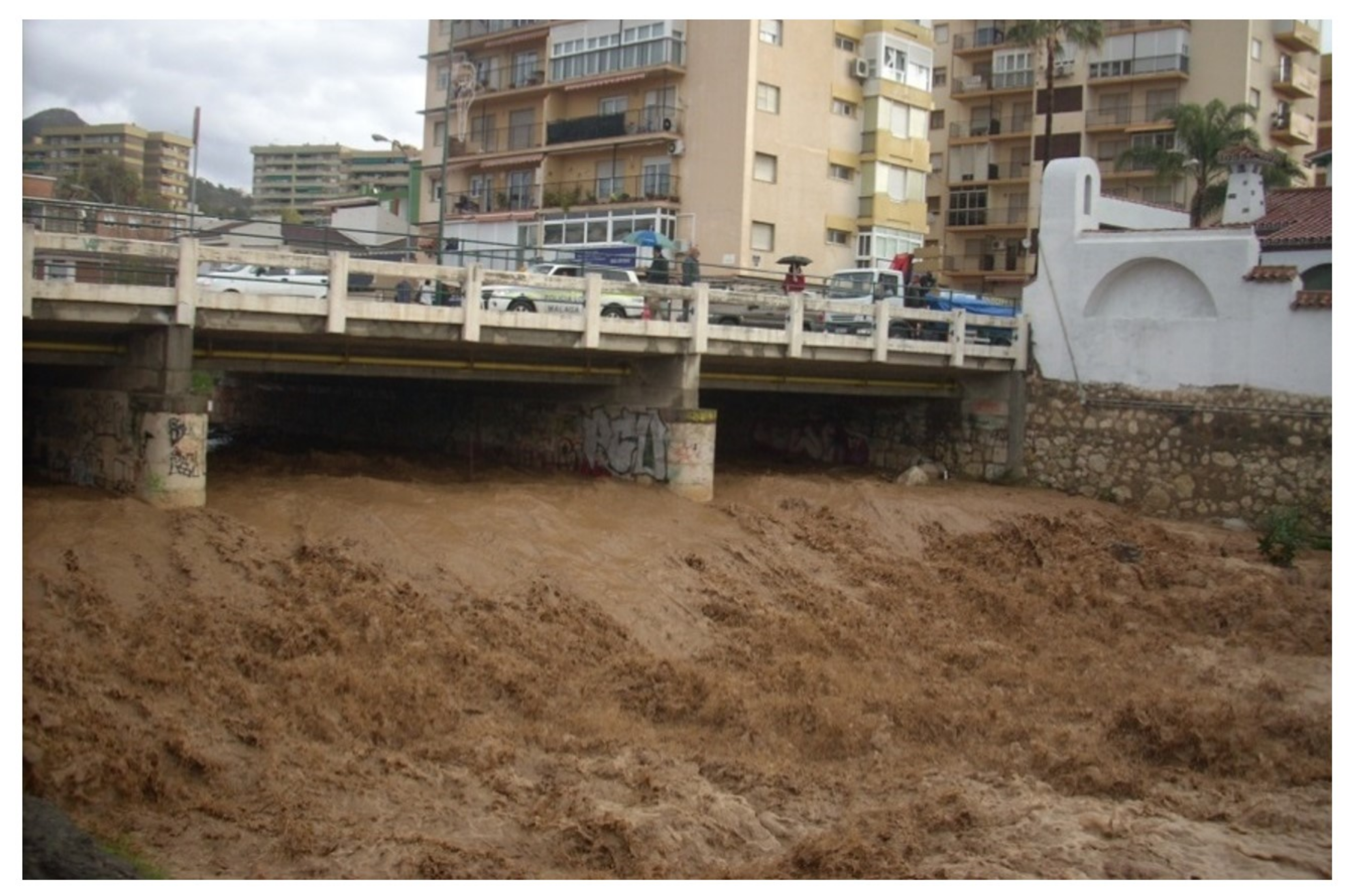
Finally, taking into account the values obtained by applying the MUSLE for a storm with a 500-year return period, the Cala River basin generates 461,000 tons of sediment, those of Rincón de la Victoria generate 149,000 and 89,000 tons (Pollo Zamora and Piletas, respectively), and the Jaboneros stream basin generates 2,155,000 tons. With the aim of excluding the surface extension of the analysis, and in order to understand the importance of this sedimentary load in the flow, it is more expressive to know that up to 19.1% of the flux are solid sediments (in the Pollo Zamora basin). In the Piletas stream, it is 18.0%, and in the Jaboneros and Cala River basins, it is 15.8% and 8.0%, respectively. Based on these data, it may be concluded a significant amount of sediment is incorporated into the flow in the basins (Figure 3). This particularity is especially remarkable in the most intense rainfall events, when streams behave as hyper-concentrated flows, that is, with a percentage of solid load greater than 25% [69].
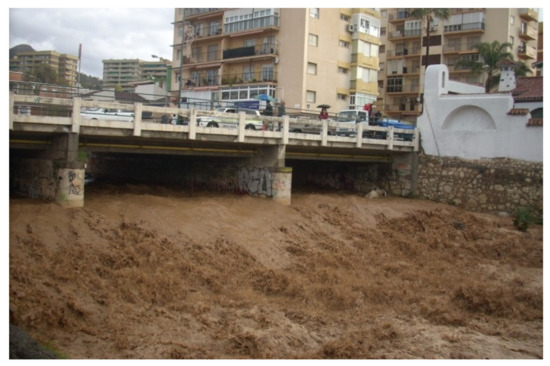
Figure 3.
Photograph of one of the bridges near the Jaboneros stream mouth, after a storm, on 7 January 2010.
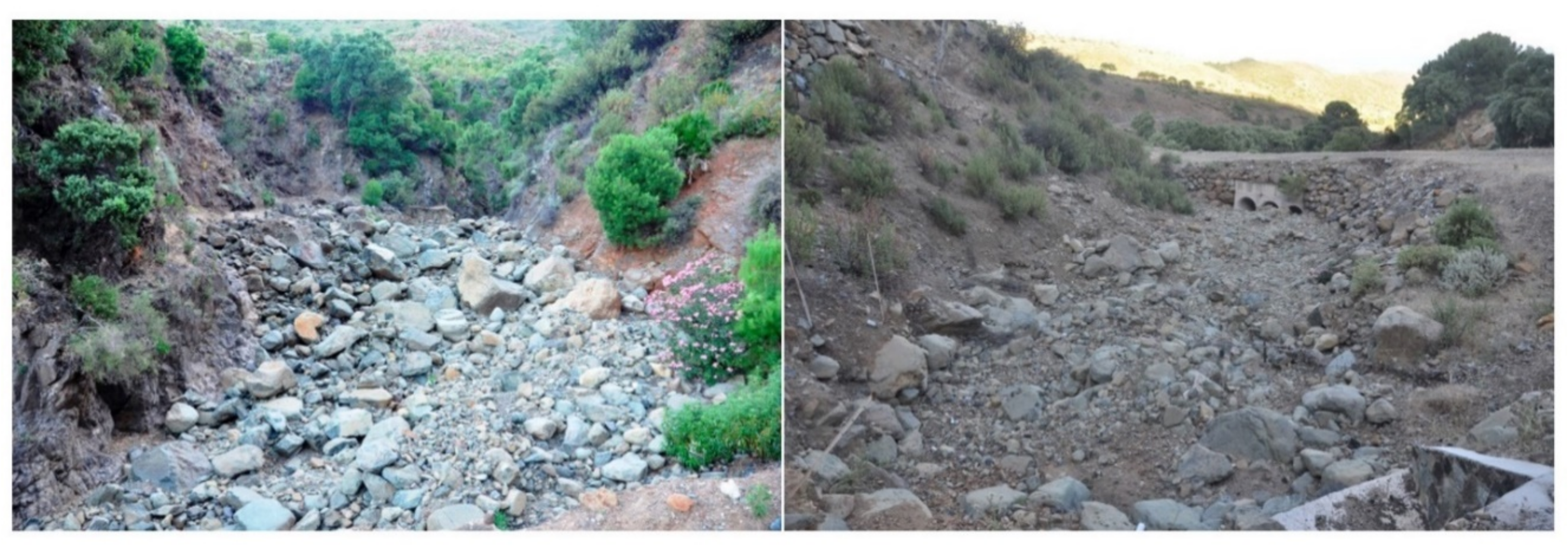
In addition to the aforementioned, numerous landslides on slopes attached to the channels can be identified in the basins, which is usually due to displacement or undermining. Where these land movements occur, the addition of solids to the flow also increases notably, with a greater mobilization of soil and a more heterometric character, which increases the probability of collapse (Figure 4).
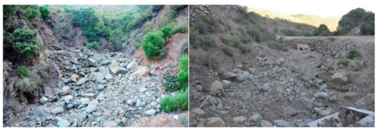
Figure 4.
Examples of the addition of heterometric sediments to the channel from the slopes in the Cala river basin. The left picture shows rocks that have fallen directly on the riverbed, and the right picture shows the problem that they generate when they are dragged to a bridge on the Cala river.
In the study areas, the erosion–transport–sedimentation processes are closely dependent on the situation of the land uses, and, in particular, on the effectiveness of the soil covers against erosion. This is the fundamental factor that explains the significant generation of sediments in the Rincón de la Victoria basins, where urban land reaches 76% of the total area. It is even more relevant that more than half of the urban land, 39% of the total area is unconsolidated urban land, which is in transformation and has earthworks. In the basins of Málaga and Estepona, land use is also the variable that determines the generation of solid load, although in these areas, it is usually related to changes between agricultural and forest areas (shrubs or trees).
Related to land uses, a special source of sediments and solid load is the frequency of deposits, excavations, fillings, and discharges of debris and rubble. They frequently come from urban constructions, and since they are deposited without following compaction or sealing measures, they are easily mobilized, even before a rainfall event (Figure 5).
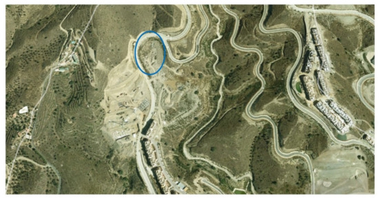
Figure 5.
Partial image of the northern sector of the Piletas–Pollo Zamora basins, showing urban lands, plots in transformation, and areas with earthworks and accumulation of debris (blue circle). These deposits are incorporated into runoff flows not only during storms but also in events of low magnitude.
4.4. Evolution of Land Uses and Urban Pattern
The settlement system in the Cala river basin has followed a clearly dual model, with a narrow urban band along the coast and an extensive peri-urban development zone, in which rural, tourist, agricultural, and second residence land uses are combined, all of them with a strong regional character. In this model, two fundamental elements should be highlighted: the influence of the tourist center formed by Marbella-San Pedro-Estepona, developed between a coastal mountain range and the N-340 road; and on the other hand, the historical agricultural uses favored by the Cala River, which nowadays still remains despite the urban and tourist development thanks to the protection granted by municipal planning. However, the pressure to transform this territory into a tourist area has been high, and it has decreased in the last years due to the slowdown produced by the bad economic situation.
The urban areas are located next to the N-340 national highway and in the part of the urban core within the basin. The population and settlements maintained a constant and moderate evolution during the first half of the last century. In 1956, only 0.3% of the basin was urbanized, and until the 1970s, the real increase in population began at the same time as that in the rest of the municipalities of the Costa del Sol. Thus, between 1977 and 2010, the percentage of urbanized land has risen from 0.8 to 5.2% (Figure 6).
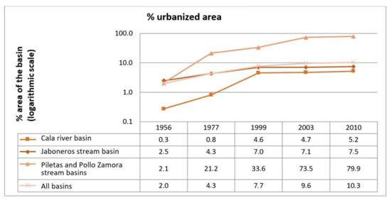
Figure 6.
Evolution of the urban land in the basins between 1956, 1977, 1999, 2003, and 2010.
In the area of agricultural uses, a very specific landscape has been developed, which is called “los campitos” [70]. It is the consequence of successive divisions and subdivisions of family plots, when they are inherited, and where renting is not usual. In this area, agricultural uses, mainly irrigated orchards, are combined with precarious second regular residence homes. Only in very specific areas houses are gathered, so, overall, the area maintains a distinctly rural character. According to local technicians, 70% of these homes are illegal, since they only can be used to store tools, up to 30 m2. This not only leads to a structural maladjustment to the different hazards of the basin but also to a great vulnerability due to the disconnection of the territorial pattern and the lack of control by the authorities—all this despite the fact that the number of inhabitants is lower than in other areas.
This illegal framework, which can also be observed in most of the Mediterranean coast [1], has its own cultural or even ethnographic connotations in the area, not only with “los campitos” in Estepona but also with “los cortinales” in Casares or “las colonias” in San Pedro de Alcántara. To the east, in Marbella, tourism development modifies this model.
Regional and local authorities do not have the tools or the will to conserve and restore these rural spaces, and whereas in Spain, it is a landscape with economic and cultural problems, in France, for example, it is balanced thanks to policies addressed to revitalize the rural landscape, both for its maintenance, the economic profits, and their environmental and landscape interest.
In the Jaboneros stream basin, land uses follow the traditional agricultural model of the Montes de Málaga-Axarquía region, although in recent decades, these uses have been progressively abandoned. This abandonment began at the end of the 19th century due to the phylloxera plague and has subsequently been emphasized by the change in the production model around Málaga. Today, agricultural uses only occupy one-fifth of the total area, whereas more than half of the basin is devoted to forest and scrubland. On the other hand, urban development in the basin is directly linked to the growth of urban and peri-urban areas in Málaga city, being able to establish the boundary between them in the A-7 highway.
The progressive abandonment of agricultural lands lasts until the middle of the twentieth century, since in the 1960s, a productive change takes place, which values the semi-natural spaces in the surroundings of Málaga [15], and it is simultaneous to its great population increase. Along with the development of phenomena such as the increasing interest of the population to reside in quieter environments with a higher environmental quality, these areas began to be settled by people with medium-high purchasing power, which bought isolated large single-family homes. During this period, the Pinares de San Antón and Cerrado de Calderón neighborhoods are developed at the eastern and western parts of the basin, respectively. Along with these developments, there are others with a lower socio-economic level, such as La Mosca and La Cerrajerilla, based on self-construction on rustic soils (Figure 7). In these cases, the origin of peri-urbanization is the need to access cheaper houses.
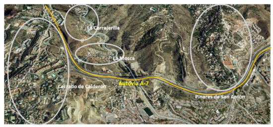
Figure 7.
Peri-urban growth in the Jaboneros stream basin. Along with the land occupied by road infrastructures, there are four residential developments with different construction typologies and socio-economic levels (Cerrado de Calderón, Pinares de San Antón, La Mosca, and La Cerrajerilla). The first two of these are standard residential developments, but the third is characterized by informal, unplanned construction, poor organization, and few services. The fourth exemplifies diffuse residential construction.
In both cases, unsuitable lands for residential use are developed, which are essentially due to the relief and several natural hazards. However, the afforestation of Monte San Antón (Pinares de San Antón) decreased the risk of soil erosion, mass movements, and runoff generation, although it generated others, such as the probability of wildfires. Additionally, the vulnerability of the population that lives in these spaces is high, since they are not used to the new semi-rural environment.
From this period until the end of the century, urban areas increased at the highest rate, from 2.5 to 7% of the basin (Figure 6). In the subsequent period, between 2000 and 2010, during the real estate boom, peri-urban growth in the basin is restricted by general urban planning plans, and it is limited to the development of interstitial areas to the south of the highway. Other land uses in the basin do not significantly change (Table 9).
Table 9.
Area of the basin that change land use between 1956, 1999, 2003, and 2010.
Finally, regarding the Piletas and Pollo Zamora basins, both their own urban configuration and that of their surroundings have their origin in the urban and tourist developments of the 1960s and 1970s. Previously, there was a low development linked to agricultural and fishing activities. The urban development of these decades is related to the incipient new function of the area as a place for second regular residence and summer vacation homes for families from Málaga. The urban growth followed the urban planning law from 1956. The urbanization carried out at that time occupied the coastal strip and was separated from each other by streams, which began to be uncovered channels.
This urban growth has followed a rural urbanization by urban diffusion from Málaga. Although there has also been endogenous urbanization, the fundamental origin of the growth has been the urban decentralization of the biggest city in the area, which promotes exogenous urbanization. Anyway, it developed as a space of proximity devoid of any other connotation of functional relationship [71]. Both endogenous and exogenous development follow a model of dissociation between the place of residence and the workplace or places of leisure. In relation to this, at some point, second regular residence homes became main residences [72].
Focusing on the study area, the growth during the 1960s and 1970s multiplied the urban land by 10, from 2% to 21% of the total area of the basin. In a second stage, during the 1980s and 1990s, the zone between the coastline and the future A-7 highway was filled up, covering one-third of the basins. Between 2000 and 2010, the area to the north of the highway began, and practically all the mountainous area of the basin was filled up, reaching 80% of the basins. It is in this last stage when second regular residence homes were converted into main residences, which was thanks to the urban boom and the highway connection between Rincón de la Victoria and Málaga. At the end of these processes, 45% of the natural areas and 32% of the agricultural areas became urban land. In addition to other insignificant changes, during these fifty years, only 17% of the basin has maintained its initial use (Table 9).
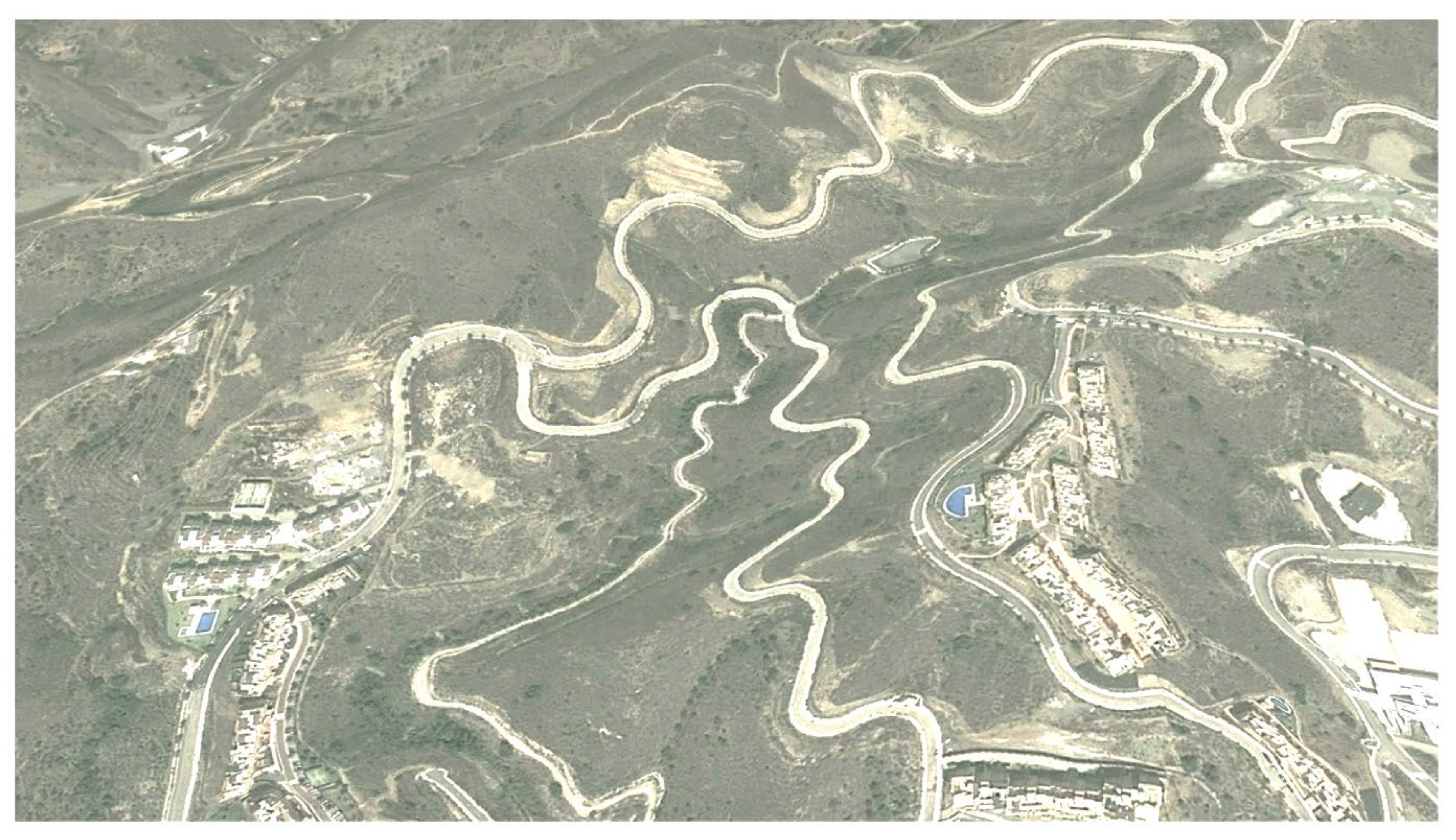
On the other hand, it is worth highlighting the road network developed in the northern half of the basins. As can be seen in Figure 8, this has involved about 10 km of leveling, with a 9-m road width that reaches 25–50 m if clearings are added (road and slopes). In addition, several dumping sites have been created, where the extracted materials have been dumped, creating large terraces with large embankments. Given the geological and geomorphological characteristics of the basins, it will not be easy to restore the balance in order to mitigate the increasing hazard of floods and mass movements.

Figure 8.
Detail of roads and clearings in the upper basins of the Piletas and Pollo Zamora streams (2007 image).
In relation to the hydraulic systems of the area, from a physical point of view, urban growth has enclosed the streams and removed their preferential flow paths and floodplains; and from a human point of view, it has not only increased the amount of assets and people but also their vulnerability, since people are unaware of the functioning of these river systems. The territorial pattern designed for the area, instead of being preventive, masks, ignores, and even enhances the risk of flooding.
On the other hand, the filling up of the basins up to its highest parts has produced a waterproofing on the territory that notably modifies the runoff calculated when building hydraulic infrastructures, which become useless. In addition, large amounts of sediments have been generated, causing erosion and the terracing of channels.
5. Discussion
Following the initial hypothesis and objectives, this work confirms the importance of human inducement in the hazard generation, especially in peri-urban zones (interface). Human-made hazards, in conjunction with natural hazards, are more destructive. It should be noted that ignoring or partially considering multi-hazards in risk assessment will lead to an overestimation of or overlooking of resilient and recovery action managements. This line of research is discussed by authors as Fathianpour et al. [21]. Confirming this hypothesis, in the Spanish Mediterranean coast, Pérez et al. [73] state that despite the construction of a large number of infrastructures aimed at mitigating the risk of flooding, the damage has not diminished, so, according to the authors, it is necessary to think about the effectiveness of these actions and to consider other measures of analysis and prevention. On the other hand, as stated by Wang et al. [67], it is clear that once the occurrence of multiple hazards is accepted, the interactions between these hazards should also be evaluated. To do so, clear and standardized methodologies are necessary. In this regard, the work of Tilloy et al. [65], who use a bibliographic database to identify interrelationships between multiple hazards, should be mentioned. Gallegos and Perles [63] have also worked on specific methodologies for the interrelation between hazards of flood and soil erosion. In this holistic approach, the present work focuses on the hazard inducement and deals with urban development beyond its relationship with vulnerability and exposure, which is commonly analyzed.
Based on the peri-urbanization models considered in the analysis, the one with the lowest resilience is that of the Piletas and Pollo Zamora basins, both due to their uncontrolled urban development and their geomorphological characteristics (rugged relief, leptosols, and abandoned crops). In these two basins, the runoff threshold between 1956 and 2010 has fallen to 38% and 13%, and the addition of sediments and solid load to the flow due to the erosion of their soils has increased to 435% and 219%. On the other hand, the results of the Jaboneros basin, where there are also peri-urban development patterns, sometimes uncontrolled, show that due to the reforestation policies, the runoff threshold increase by 117%, and the addition of sediments and solid load due to soil loss remains constant.
The main causes that induce hazard observed in the study areas are the rapid and forced changes in the historical hydraulic dynamics of the flow, the changes and abandonment of land use, the increase in water erosion due to the destructuring of soils, the inducement to gravitational movements, and the dam of the streams by roads and infrastructures.
6. Conclusions
The main contribution of this work is the classification, characterization, and quantification of the changes produced by urbanization processes in peri-urban and interface areas in the relief, and in the functioning of the morphogenetic processes that determine the production of multiple risks. Other works are focused on the study of the relations between risk processes and territorial processes. Those works usually lack a holistic approach to analyze flooding and associated risks, which is essential to realistically and effectively assess and prevent risk in peri-urban areas of the Mediterranean coast. However, in contrast to previous works, this research focuses on empirical analyses that have a more precise impact on the knowledge of multiple risks and on their interactions and synergies as well as on the specific consequences of urbanization when inducing and activating risk processes.
The results allow concluding the predominant negative effect of the changes generated by urbanization in peri-urban areas regarding the generation of multiple risks. Activities linked to urbanization produce an alteration in the shape and dynamics of the geomorphological processes that induce risk, either by activating latent processes or by emphasizing the conditioning factors of risk.
It has been shown that the runoff threshold and the vegetation cover (factor C of the USLE) are the most sensitive parameters to the hazard increase by the urbanization process in peri-urban areas. In addition, it can be observed that overall, the most susceptible territorial model to change features scattered urban areas in basins with thin soils, low vegetation cover, and steep slopes, which in the Spanish Mediterranean coast are usually associated with peri-urban touristic development or secondary residence areas. Therefore, these areas are one of the spaces where authorities have to focus on, since they have problems and potentialities due to their location and their recent development [74]. From the risk point of view, they are very fragile and highly dynamic, which need preferential attention. The analyzed study areas are characteristic of this model, and they bring together an amalgam of different uses, in which activities from the primary and the tertiary sectors are spatially concurrent. These contrasts also involve different intensities, where heterogeneous and inconsistent territorial patterns emerge. Thus, this characteristic aspect of the peri-urban areas of the Mediterranean coast is an inconvenience for the characterization of these risk areas.
It is necessary to keep on using a systemic and territorial approach to face natural risks. The analysis of the risk as a territorial process eases its understanding and allows it to be faced more effectively. In addition, this also brings the analysis of flooding and risks associated with territorial planning closer to urban and territorial planning, since it is focused on specific areas.
Thus, from the analysis carried out in this research, it is concluded that there is a need for a holistic approach to analyze the associated risks in the peri-urban areas of the Mediterranean coast, as well as the unavoidable study of the interactions between risk processes and territorial processes.
Author Contributions
Conceptualization, Antonio Gallegos Reina and María Jesús Perles Roselló; methodology, Antonio Gallegos Reina; software, Antonio Gallegos Reina; validation, Antonio Gallegos Reina; formal analysis, Antonio Gallegos Reina; investigation, Antonio Gallegos Reina and María Jesús Perles Roselló; resources, Antonio Gallegos Reina; data curation, Antonio Gallegos Reina; writing—original draft preparation, Antonio Gallegos Reina; writing—review and editing, María Jesús Perles Roselló; visualization, Antonio Gallegos Reina and María Jesús Perles Roselló; supervision, María Jesús Perles Roselló; project administration, María Jesús Perles Roselló; funding acquisition, María Jesús Perles Roselló. All authors have read and agreed to the published version of the manuscript.
Funding
This research was funded by UMA18-FEDERJA-238 (Vulnerabilidad de centros docentes andaluces frente a riesgos naturales múltiples (sísmico, movimientos del terreno e inundación). Evaluación integral y propuestas para la gestión de la catástrofe), awarded in the call for R & D & I projects within the framework of the ERDF Operational Program ‘Andalusia 2014–2020’ of the Ministry of Economy and Knowledge of the Junta de Andalucía.
Institutional Review Board Statement
Not applicable.
Informed Consent Statement
Not applicable.
Data Availability Statement
The data presented in this study are available on request from the corresponding author.
Conflicts of Interest
The authors declare no conflict of interest.
References
- De Orueta, E.L.B. La “década prodigiosa” del urbanismo español (1997–2006). Scripta Nova 2008, XII, 64. [Google Scholar]
- Pesaresi, M.; Ehrlich, D.; Kemper, T.; Siragusa, A.; Florczyk, A.J.; Freire, S.; Corbane, C. Atlas of the Human Planet 2017: Global Exposure to Natural Hazards; European Commission, DG Join Research Center: Ispra, Italy, 2017; p. 92. [Google Scholar]
- Camarasa Belmonte, A.M. Flash-flooding of ephemeral streams in the context of climate change. Cuadernos de Investigación Geográfica 2021, 47, 121–142. [Google Scholar] [CrossRef]
- Hugonie, G. Aux marges des villes, des risques ‘naturels’ accrus, l’example de la banlieue parisienne. Bulletin de l’Association des Géographes Français 2001, 78, 375–384. [Google Scholar] [CrossRef]
- Entrena Durán, F. Procesos de periurbanización y cambios en los modelos de ciudad: Un estudio europeo de casos sobre sus causas y consecuencias. Papers 2005, 78, 59–88. [Google Scholar]
- D’Ercole, R.; Thouret, J.C. Croissance urbaine et risques naturels: Présentation introductive. Bulletin de l’Association des Géographes Français 1995, 4, 311–336. [Google Scholar] [CrossRef]
- Bernabé, M.A. Expansión urbana y su influencia en el riesgo hídrico en el área urbana y periurbana de Tandil. In Proceedings of the Primer Congreso de la Ciencia Cartográfica y VIII Semana Nacional de Cartografía, Buenos Aires, Argentina, 25–27 July 2003. [Google Scholar]
- Hernández, J.; Vieyra, A. Riesgo por inundaciones en asentamientos precarios del periurbano. Morelia, una ciudad media mexicana. El desastre nace o se hace? Revista de Geografía Norte Grande 2010, 47, 45–62. [Google Scholar] [CrossRef]
- Gallegos Reina, A. Particularidades de la periurbanización en el litoral mediterráneo como condicionante del riesgo de inundabilidad. In Riesgo de Inundación en España: Análisis y Soluciones Para la Generación de Territorios Resilientes; Universitat d’Alacant: Alicante, Spain, 2020; pp. 325–331. [Google Scholar]
- Mérida Rodríguez, M. El Monte San Antón (Málaga): Análisis de un Espacio Natural Periurbano (Textos Mínimos); Universidad de Málaga: Málaga, Spain, 1994. [Google Scholar]
- Veyret, Y.; Beucher, S.; Bonnard, J.Y. Risques naturels et territories. BAGF Geogr. 2005, 82, 63–75. [Google Scholar] [CrossRef]
- Schneider, A. Understanding urban Growth in the context of Global Change. IHDP Newsletter 2006, 2, 17–30. [Google Scholar]
- Vidal, C.; Romero, H. Efectos ambientales de la urbanización de las cuencas de los ríos Bíobío y Andalién sobre los riesgos de inundación y anegamiento de la ciudad de Concepción. In Concepción Metropolitano (AMC): Planes, Procesos y Proyectos; Pérez, L., Hidalgo, R., Eds.; Serie GEOlibros; Instituto de Geografía, Pontificia Universidad Católica de Chile: Santiago, Chile, 2010. [Google Scholar]
- Razkin Fraile, M. De la Potencialidad a la Realidad en la Franja Periurbana del Norte de Pamplona. Euskonews & Media 181.zbk, 27 September/4 October 2002. Available online: https://www.euskonews.eus/0181zbk/gaia18102es.html (accessed on 25 October 2021).
- Perles Roselló, M.J.; Mérida Rodríguez, M. Patrón territorial y conformación del riesgo en espacios periurbanos. El caso de la periferia Este de la ciudad de Málaga. Scripta Nova 2010, 14, 199983. [Google Scholar]
- Hewitt, K. Regions of Risk: A Geographical Introduction to Disasters; Longman: London, UK, 1997. [Google Scholar]
- Calvo García-Tornel, F. Sociedades y Territorios en Riesgo; Ediciones del Serbal: Barcelona, Spain, 2001. [Google Scholar]
- Cutter, S.; Boruff, B.; Shirley, W. Social vulnerability to environmental hazards. Soc. Sci. Q. 2003, 84, 242–261. [Google Scholar] [CrossRef]
- Olcina Cantos, J. Cambios en la consideración territorial, conceptual y de método de los riesgos naturales. In Diez años de Cambios en el Mundo, en la Geografía y en las Ciencias Sociales (1998–2008); Actas del X Coloquio Internacional de Geocrítica: Barcelona, Spain, 2008. [Google Scholar]
- Perles Roselló, M.J. Territorial pattern and risk development. Contributions for a more efficient planning and management of high-risk territories. In Spain, Bridgue between Continents; Centro Nacional de Información Geográfica: Madrid, Spain, 2020. [Google Scholar] [CrossRef]
- Fathianpour, A.; Jelodar, M.B.; Wilkinson, S. Developing Improvements to Multi-Hazard Risk Assessments. Int. J. Civ. Environ. Eng. 2019, 13, 692–697. [Google Scholar]
- Luce, C.; Wemple, B. Introduction to Special Issue on Hydrologic and Geomorphic Effects of Forest Roads. Earth Surf. Process. Landforms. 2001, 26, 111–113. [Google Scholar] [CrossRef]
- Corominas, J.; Ibarbia, I.; Luzuriaga, S.; Navarro, J.A.; Jujo, I.; Jurnet, C.; Hurlimann, M. Rockfall and debris flow hazard assesment of the coastal road of Guipuzkoa (Northern Spain). In Landslides Science and Practice; Risk Assesment, Management and Mitigation; Margottini, C., Canuti, P., Sassa, K., Eds.; Springer: Berlin/Heidelberg, Germany, 2013; Volume 6. [Google Scholar]
- Pérez Morales, A.; Gil Guirado, S.; Olcina Cantos, J. Housing bubbles and the increase of flood exposure. Failures in flood risk management on the Spanish south eastern coast (1975–2013). J. Flood Risk Manag. 2018, 11, S302–S313. [Google Scholar] [CrossRef]
- Membrado Tena, J.C. Sunny Spain: Migrantes del sol y urbanismo expansivo en el litoral mediterráneo español. Ciudad y Territorio 2013, XLV, 687–708. [Google Scholar]
- Pérez Morales, A.; Romero Díaz, A.; Caballero Pedraza, A. Procesos de urbanización y su influencia en el incremento de inundaciones (Sureste de España, Región de Murcia, Campo de Cartagena-Mar Menor). In Crisis, Globalización y Desequilibrios Sociales y Territoriales en España; Aportación Española al 33 Congreso de Beijing; Comité español de la UGI: Madrid, Spain, 2016; pp. 97–109. [Google Scholar]
- Gaja, F. Reparar los impactos de la burbuja constructora. Scripta Nova Revista Electrónica de Geografía y Ciencias Sociales 2015, XIX, 1–37. [Google Scholar]
- Villar Lama, A.; Ojeda Zujar, J. Evolución reciente de los suelos urbanos alterados en el litoral de Andalucía (1998–2994). In Territorios, Sociedades y Políticas; Asociación de Geógrafos Españoles y Universidad Pablo de Olavide: Sevilla, Spain, 2009; pp. 143–156. [Google Scholar]
- Ortega Becerril, J.A. Implicaciones de las actividades antrópicas en el riesgo de inundaciones. Consecuencias para la cartografía de riesgos”. In Mapas de Riesgos Naturales en la Ordenación Territorial y Urbanística; González García, J.L., Ed.; Ilustre Colegio Oficial de Geólogos: Madrid, Spain, 2008; pp. 85–92. [Google Scholar]
- Segura Beltrán, F. Geomorfología, inundaciones y alteración antrópica del espacio inundable: El caso del riu Girona (Alacant, octubre de 2007). Boletín de la Asociación de Geógrafos Españoles 2009, 49, 83–103. [Google Scholar]
- Segura Beltrán, F.S.; Sanchís Ibor, C. Estrechamiento de cauces y cambio de patrón en cursos fluviales mediterráneos como consecuencia del cambio global en las últimas seis décadas: Indicadores geomorfológicos. In Geomorfología del Antropoceno: Efectos del Cambio Global Sobre los Procesos Geomorfológicos; García, C., Gómez-Pujol, L., Moran-Tejeda, E., Batalla, R.J., Eds.; Universitat de les Illes Balears; Sociedad Española de Geomorfología: Palma, Spain, 2018; pp. 393–398. [Google Scholar]
- Baena Escudero, R.; Guerrero Amador, I.; García Martínez, B.; Posada Simeón, J.C. Ocupación antrópica y riesgos de inundación en la llanura del río Guadalquivir (sector Palma del Río-Sevilla, España). Boletín de la Asociación de Geógrafos Españoles 2016, 72, 149–167. [Google Scholar] [CrossRef] [Green Version]
- Romeu, E.; Segura Beltrán, F.S. Cambios en los usos del suelo y repercusiones sobre las inundaciones: El caso del Maresme. In XV Coloquio Ibérico de Geografía: Retos y Tendencias de la Geografía Ibérica; Universidad de Murcia—AGE: Murcia, Spain, 2016; pp. 347–356. [Google Scholar]
- Pascual, J.A.; López, M.J. Cambios recientes en los usos del suelo y sus implicaciones ambientales. In El Territorio Valenciano: Transformaciones Ambientales y Antrópicas; Mateu Belles, J., Ed.; Universitat de València: València, Spain, 2016; pp. 17–20. [Google Scholar]
- Gallegos Reina, A.; Perles Roselló, M.J. Relaciones entre los cambios en los usos del suelo y el incremento de los riesgos de inundabilidad y erosión: Análisis diacrónico en la provincia de Málaga (1957–2007). Boletín de la Asociación de Geógrafos Españoles 2019, 81, 1–38. [Google Scholar] [CrossRef]
- Caballero Pedraza, A. Resumen de la tesis doctoral Sellado de Suelos en la Comarca del Mar Menor (Murcia). Consecuencias Medioambientales. Boletín de la Asociación de Geógrafos Españoles 2018, 76, 562–565. [Google Scholar]
- Conesa García, C.; García Lorenzo, R.; Pérez Cutillas, P. Flood hazards at ford stream crossings on ephemeral channels (south-east coast of Spain). Hydrol. Process. 2017, 31, 731–749. [Google Scholar] [CrossRef]
- Conesa García, C.; García Lorenzo, R. Evaluating the effectiveness of road-crossing drainage culverts in ephemeral streams. Hydrol. Process. 2013, 27, 1781–1796. [Google Scholar] [CrossRef]
- Conesa García, C.; García Lorenzo, R. Flood hazard assessment for bridge crossings over ephemeral channels: A case study of the Murcia Coast (SE Spain). Cuadernos de Investigación Geográfica 2014, 40, 117–143. [Google Scholar] [CrossRef] [Green Version]
- Cantarero Prados, F. Relaciones Entre el Patrón Territorial y la Generación del Peligro de Inundación: Análisis Comparado de Casos en Málaga (España) y Motozintla (México). Ph.D. Thesis, Universidad de Málaga, Málaga, Spain, 2013. [Google Scholar]
- Gallegos Reina, A. Caracterización de Cuencas Fluviales Periurbanas con Riesgo de Inundación en Ámbitos Mediterráneos y Propuesta de Cartografía de Peligrosidad Adaptada. Ph.D. Thesis, Universidad de Málaga, Málaga, Spain, 2015. Available online: http://riuma.uma.es/xmlui/handle/10630/10576 (accessed on 25 October 2021).
- Gallegos Reina, A. Inundaciones en el litoral mediterráneo español en el actual contexto de Cambio Climático: Orientaciones para su análisis y gestión. Estudio en la cuenca del arroyo Piletas (Málaga). Ería Revista de Geografía 2021, 2021-1, 33–53. [Google Scholar] [CrossRef]
- Grimalt-Gelabert, M.; Llinàs, J.; Genovart-Rapado, M. The flood of October 9, 2018 in the city centre of Sant Llorenç des Cardassar (Mallorca). Cuadernos de Investigación Geográfica 2021, 47, 265–286. [Google Scholar] [CrossRef]
- Ruíz, J.D.; Romero, A.; Belmonte, F. El urbanismo como acelerador de los procesos de degradación del suelo. Colinas del Limonar, Málaga. In XXII Congreso de Geógrafos Españoles; Asociación de Geógrafos españoles: Málaga, Spain, 2011; pp. 629–640. [Google Scholar]
- Díez Herrero, A.; Garrote Revilla, J. Publicaciones científicas españolas sobre inundaciones en el ámbito internacional: Análisis bibliométrico de la web of science. In Riesgo de Inundación en España: Análisis y Soluciones para la Generación de Territorios Resilientes; Universitat d’Alacant: Alicante, Spain, 2020; pp. 1321–1329. [Google Scholar]
- Perles Roselló, M.J.; Gallegos Reina, A.; Cantarero Prados, F. Análisis del ajuste del área inundable obtenida mediante una evaluación integrada de la peligrosidad de inundación y peligros asociados. Baética Estudios de Arte Geografía e Historia 2006, 1, 527–545. [Google Scholar] [CrossRef]
- Cutter, S.; Emrich, C.; Gale, M.; Reevers, R. Flash Flood Risk and the Paradox of Urban Development. Nat. Hazards Rev. 2018, 19, 05017005. [Google Scholar] [CrossRef]
- Carpignano, A.; Golia, E.; Di Mauro, C.; Bouchon, S.; Nordvik, J.P. A methodological approach for the definition of multi-risk maps at regional level: First application. J. Risk Res. 2009, 12, 513–534. [Google Scholar] [CrossRef]
- Cozzani, V.; Gubinelli, G.; Gntonioni, G.; Spadoni, B.; Zanelli, S. The assessment of risk caused by domino effect in quantitative area risk analysis. J. Hazard Mater. 2005, 127, 14–30. [Google Scholar] [CrossRef]
- Delmonaco, G.; Margottini, C.; Spizzino, D. Report on New Methodology for Multi-Risk Assessment and the Harmonisation for Different Natural Risk Maps. ARMONÍA Project: Applied Multirisk Mapping of Natural Hazards for Impact Assessment. Deliverable 3.1. European Community. 2006. Available online: https://www.researchgate.net/publication/317957266_New_methodology_for_multi-risk_assessment_and_the_harmonisation_of_different_natural_risk_maps (accessed on 25 October 2021).
- Baoyin, L.; Yim Ling, S.; Gordon, M. Hazard interaction analysis for multi-hazard risk assessment: A systematic classification based on hazard-forming environment. Nat. Hazards Earth Syst. Sci. 2016, 16, 629–642. [Google Scholar]
- Kappes, M.S.; Keiler, M.; von Elverfeldt, K.; Glade, T. Challenges of analyzing multi-hazard risk: A review. Nat. Hazards 2012, 64, 1925–1958. [Google Scholar] [CrossRef] [Green Version]
- Gill, J.C.; Malamud, B.D. Reviewing and visualizing the interactions of natural hazards. Rev. Geophys. 2014, 52, 680–722. [Google Scholar] [CrossRef] [Green Version]
- Gallina, V.; Torresan, S.; Critto, A.; Sperotto, A.; Glade, T.; Marcomini, A. A review of multi-risk methodologies for natural hazards: Consequences and challenges for a climate change impact assessment. J. Environ. Manag. 2016, 168, 123–132. [Google Scholar] [CrossRef]
- Pelling, M.; Blackburn, S. Megacities and the Coast: Risk, Resilience and Transformation; Routledge: UK, 2014. [Google Scholar]
- Hart, D.E.; Hawke, K.A. Multi-Hazard Flooding Interactions in the Ōpāwaho Heathcote Catchment; University of Canterbury: Christchurch, New Zealand, 2016. [Google Scholar]
- Sanchís Ibor, C.; Segura Beltrán, F.; Almonacid Caballer, J. Channel forms recovery in an ephemeral river after gravel mining (Palancia River, Eastern Spain). Catena 2017, 158, 357–370. [Google Scholar] [CrossRef] [Green Version]
- Navarro, A.; Sanchís, C.; Segura, F. Cambios morfológicos en el cauce del río Serpis tras la construcción del embalse de Beniarrés (Alicante, 1958–2013). In Comprendiendo el Relieve: Del Pasado al Futuro; Durán Valsero, J.J., Montes Santiago, M., Robador Moreno, A., Salazar Rincón, A., Eds.; Instituto Geológico y Minero de España (IGME): Madrid, Spain, 2016; pp. 399–406. [Google Scholar]
- Cerdà, A.; Novara, A.; Moradi, E. Long-term non-sustainable soil erosion rates and soil compaction in drip-irrigated citrus plantation in Eastern Iberian Peninsula. Sci. Total Environ. 2021, 787, 147549. [Google Scholar] [CrossRef]
- Bout, B.; Lombardo, L.; van Westen, C.J.; Jetten, V.G. Integration of two-phase solid fluid equations in a catchment model for flashfloods, debris flows and shallow slope failures. Environ. Model. Softw. 2018, 105, 1–16. [Google Scholar] [CrossRef]
- Kumbier, K.; Carvalho, R.C.; Vafeidis, A.T.; Woodroffe, C.D. Investigating compound flooding in an estuary using hydrodynamic modelling: A case study from the Shoalhaven River, Australia. Nat. Hazards Earth Syst. Sci. 2018, 18, 463–477. [Google Scholar] [CrossRef] [Green Version]
- Perles Roselló, M.J.; Cantarero Prados, F. Problemas y retos en el análisis de los riesgos múltiples del territorio. Propuestas metodológicas para la elaboración de cartografías multi-peligros. Boletín de la Asociación de Geógrafos Españoles 2010, 52, 245–271. [Google Scholar]
- Gallegos Reina, A.; Perles Roselló, M.J. Metodología para el análisis integrado de peligros asociados a la inundación: Propuesta adaptada a la ordenación territorial en regiones mediterráneas. Boletín de la Asociación de Geógrafos Españoles 2020, 86. [Google Scholar] [CrossRef]
- Perles Roselló, M.J.; Pardo García, S.; Mérida Rodríguez, M.; Olcina Cantos, J. Metodología para la predicción de puntos de riesgos múltiples en infraestructuras viarias tras episodios torrenciales (road-risk). Boletín de la Asociación de Geógrafos Españoles 2019, 80, 1–40. [Google Scholar] [CrossRef] [Green Version]
- Tilloy, A.; Malamuda, B.D.; Winterb, H.; Joly-Laugelb, A. A review of quantification methodologies for multi-hazard interrelationships. Earth-Sci. Rev. 2019, 196, 102881. [Google Scholar] [CrossRef]
- Menoni, S.; Ceudech, A.; Delmonaco, A.; Margottini, G.; Spizzichino, C. FP6 Armonia Project. Applied Multi-Risk Mapping of Natural Hazards for Impact Assessment. Deliverable 51, Harmonised Hazard, Vulnerability and Risk Assessment Methods Informing Mitigation Strategies Addressing Land-Use Planning and Management. 2006. Available online: https://cordis.europa.eu/project/id/511208/es (accessed on 25 October 2021).
- Wang, J.; He, Z.; Weng, W. A review of the research into the relations between hazards in multi-hazard risk analysis. Nat. Hazards 2020, 104, 2003–2026. [Google Scholar] [CrossRef]
- Castronovo, R. La ocupación del territorio y sus aspectos ambientales. Análisis de un sistema periurbano. VI Encuentro de Geografía de América Latina. In Temas Libres; Anagrama: Buenos Aires, Argentina, 1997. [Google Scholar]
- Gallegos Reina, A. Cuantificación y distribución cartográfica de la generación de escorrentía y sedimentos en la provincia de Málaga. Baética 2013, 35, 57–74. [Google Scholar] [CrossRef] [Green Version]
- Mérida Rodríguez, M.; Lobón Martín, R.; Pardo García, S.; Persles Roselló, M. Construcciones Dispersas y Paisaje en Municipios de la Costa del Sol: Caracterización Tipológica y Propuesta de Recuperación Paisajística; Consejería de Vivienda y Ordenación del Territorio, Actividades de Investigación en Materia de Vivienda y Arquitectura: Málaga, Spain, 2010. [Google Scholar]
- Ocaña Ocaña, C. Población y Crecimiento Urbano: Málaga a Comienzos del Siglo XXI; Fundación CIEDES: Málaga, Spain, 2005; 192p. [Google Scholar]
- Montosa Muñóz, J. Rincón de la Victoria: La Población en un Municipio Metropolitano de Málaga. Estudios y Ensayos; Universidad de Málaga: Málaga, Spain, 1997. [Google Scholar]
- Pérez Morales, A.; Romero Díaz, M.A.; Gil Guirado, S. Structural measures against floods on the Spanish Mediterranean coast. Evidence for the persistence of the “escalator effect”. Cuadernos de Investigación Geográfica 2021, 47, 33–50. [Google Scholar] [CrossRef]
- Gallegos Reina, A. Caracterización y Análisis de los Riesgos Naturales en el Planeamiento Urbanístico del Litoral Mediterráneo Español; UMA Editorial: Málaga, Spain, 2018. [Google Scholar]


Publisher’s Note: MDPI stays neutral with regard to jurisdictional claims in published maps and institutional affiliations. |
© 2021 by the authors. Licensee MDPI, Basel, Switzerland. This article is an open access article distributed under the terms and conditions of the Creative Commons Attribution (CC BY) license (https://creativecommons.org/licenses/by/4.0/).