1. Introduction
In this era of rapid economic development in China, the expansion of cities and the increasing building density have increased demand for public services [
1]. In recent years, urban development has decelerated, so more urban resources have been dedicated to improving the quality of public services within cities [
2]. The fire-protection rescue service is a key service to ensure urban safety and strongly affects the personal and property safety of residents [
3].
Judging from the classification of the fire brigade’s outings in 2020, a total of 395,000 instances of population rescues were undertaken, and 251,000 instances of fires were extinguished [
4]. Population rescues include helping people in distress, eliminating danger, and handling traffic accidents. The above data show that the number of population rescues exceeds the number of fires, so a quick response is needed to resolve problems in time and increase the population’s sense of security. Fires are one of the most serious disasters known, which seriously threaten public security and social development [
5,
6]. From 2007 to 2020, about 314 million fires occurred in China, causing property losses of CNY 36.8 billion and 20,439 deaths [
4]. Notable examples include the explosion in Tianjin Binhai New Area in 2015 and the fire in Changchun, Jilin in 2021. These fire incidents seriously affected economic activity and reveal the complexity and difficulty of fire rescue [
7]. Given this context, the rational location of fire brigades is of vital importance because it can reduce losses by shortening the emergency response time. Therefore, to improve urban fire-rescue services and thereby alleviate the seriousness of rescue events, it is crucial to study the spatial site selection of urban fire brigades.
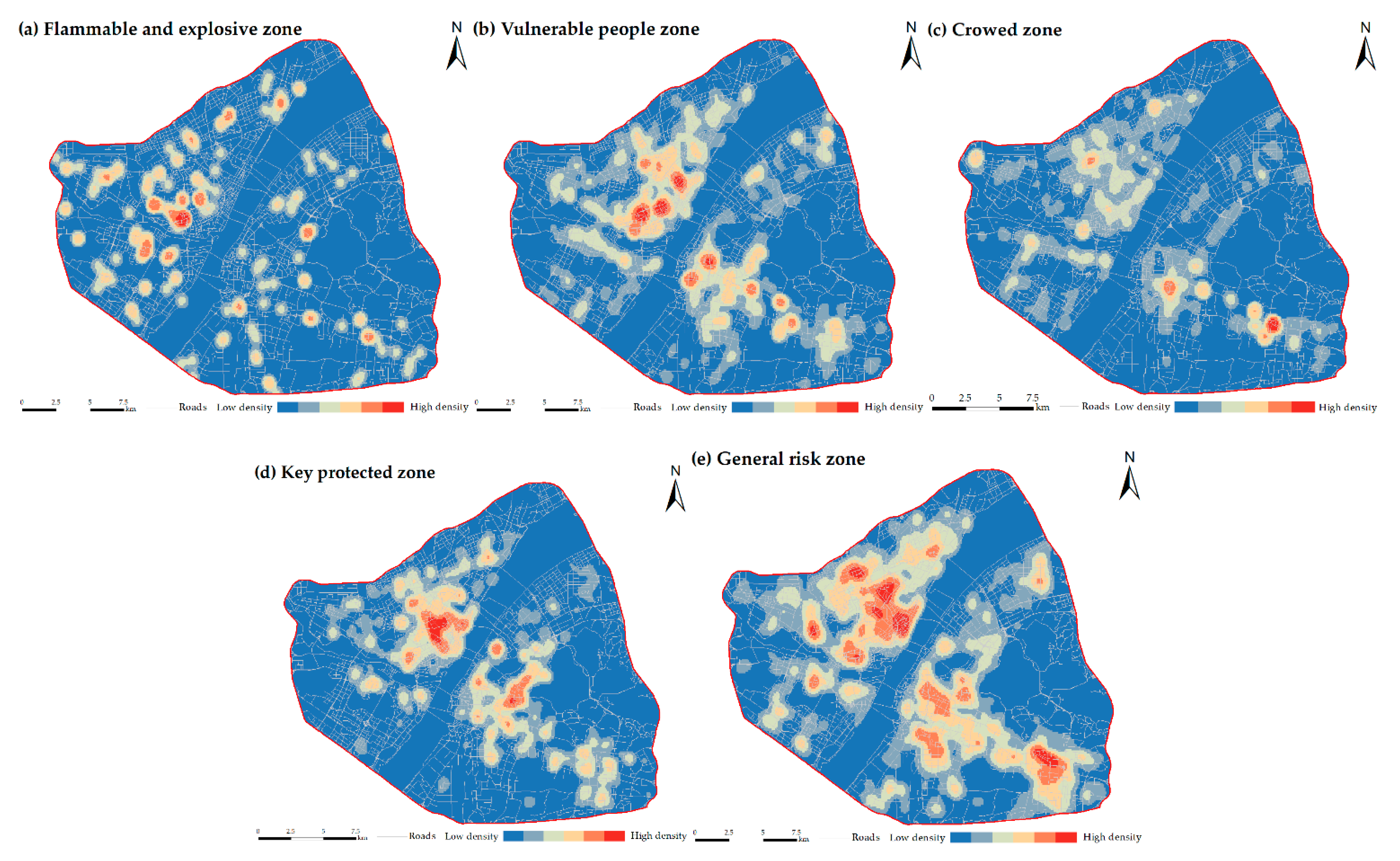
The functioning of urban areas is becoming increasingly diverse, with frequent changes in building functions and the influx of large non-local populations, resulting in excessive population density. A typical result is the emergence of zones with “all-in-one” functions, such as production, accommodation, and factories. At the same time, the complex distribution of urban functional zones such as industrial parks, residential areas, hospitals, and schools also produces differentiated and population rescue that produce different rescue requirements for fire brigades. In addition, the overall fire risk is the integration of the fire risks of all the different functional zones.
When considering the accumulation of urban fire risks and population rescue, one quickly finds a variety of new rescue problems. Concomitantly, the unique characteristics of high-rises, underground constructions, and large-scale buildings in today’s megacities have greatly increased the difficulty of fire rescue [
8]. In this context, the uncertainty and uncontrollable factors involved with fires have increased significantly, making fire prevention and control more complex [
9].
The location and layout of traditional fire brigades are divided mainly according to the nature of the land, as determined by city planners, with fire brigades at the center and the five-minute-travel-time distance serving as the radius. However, within the area of responsibility of a fire brigade, researchers tend to ignore factors that may affect fire risks, such as land cover, road width, building density, vehicle speed, and the potential for fire events and population rescue. In addition, the insufficient number of fire brigades in existing cities means that fire-rescue services lag behind actual needs [
10]. This state of affairs may significantly hinder fire-rescue services, and new ideas are urgently needed to resolve this problem by providing a scientifically sound method to position urban fire brigades.
The literature records a long history of research into the site selection of public facilities. In 1909, Weber introduced the “Weber Problem” to discuss the location of warehouses and launched theoretical research into location selection. To minimize the economic loss caused by fire and the cost to the fire brigade of their rescue services, Hogg [
11] argued in 1968 that the most important decision faced by firefighters was how many fire brigades to have and where to build them. In 1975, Helly [
12] argued that the most important attribute of fire brigade location should be that it minimizes emergency response time, which served as the basis of the fire brigade location model. This factor was used as the basis for the fire brigade site-selection model developed by Plan and Hendrick [
13], who used response time as the coverage criterion and applied the theory of site selection set coverage (LSCP) to the site-selection problem. In 1985, Reilly and Mirchandani [
14] located P stations from M candidate stations to maximize certain functions of the travel time of the first- and second-arriving fire units under several constraints. Habibi et al. [
15], Erden et al. [
16], and Chaudhary et al. [
17] used an analytic hierarch process (AHP) and geographic information systems (GISs) to select sites and analyze the optimization in various urban areas. Chen et al. [
18] proposed a simple way to optimize the location of fire brigades. This method minimizes the average driving distance for fire trucks, which is calculated by abstracting the fire brigade coverage area as a “node”. Murray et al. [
19] formed the maximum coverage location problem (MCLP) to study the site selection of fire brigades in California, USA, and proposed a system planning strategy for fire protection. Owen et al. [
20] divided the location problem into a median problem (p-median), a center problem (p-center), a location set covering problem (LSCP), an MCLP, and a maximal capacity covering location problem. Badri et al. [
21] considered multiple goals, which include travel time and travel distance from facilities to demand points. This model also considered the technical policies and standards. After extensive direct interaction with decision-makers, the model and experiments were designed to improve our understanding of the positioning of fire brigades.
The analysis of Chevalier et al. [
22] involved multiscale GISs, which included a comprehensive representation of physical, human, and economic realities, risk-modeling methods, and an appropriate optimal location and allocation model (considering queuing and staffing issues). Cath [
23] chose to evaluate the fire brigade and rescue vehicles and analyzed the logical relationship with these elements in determining the location of the fire brigade. Yang et al. [
24] combined fuzzy multi-objective programming and a genetic algorithm to determine the location of fire brigades, whereas Schreuder et al. [
25], Kanoun et al. [
26], and Liu et al. [
27] selected the location of fire brigades according to the actual situation in different regions. Other groups have approached this problem with methods such as the particle swarm algorithm [
28] and the ant colony algorithm [
27].
This review of previous research shows that location–allocation (L-A) models (e.g., LSCP, MCLP, p-center, and p-median) and GIS technology have been widely used to position fire brigades. However, the existing research is problematic: First, the current urban construction is rarely considered in the site-selection and space-optimization analysis of fire brigades. Second, the lack of detailed building structure information means that existing methods usually simulate fire events occurring on simplified plots or blocks without distinguishing between the functional heterogeneity of different buildings and the differences within the buildings. Third, detailed information on the transport network is rarely considered in site selection and spatial optimization.
The development of computer science and the Internet has led to numerous geospatial data [
29,
30,
31,
32,
33,
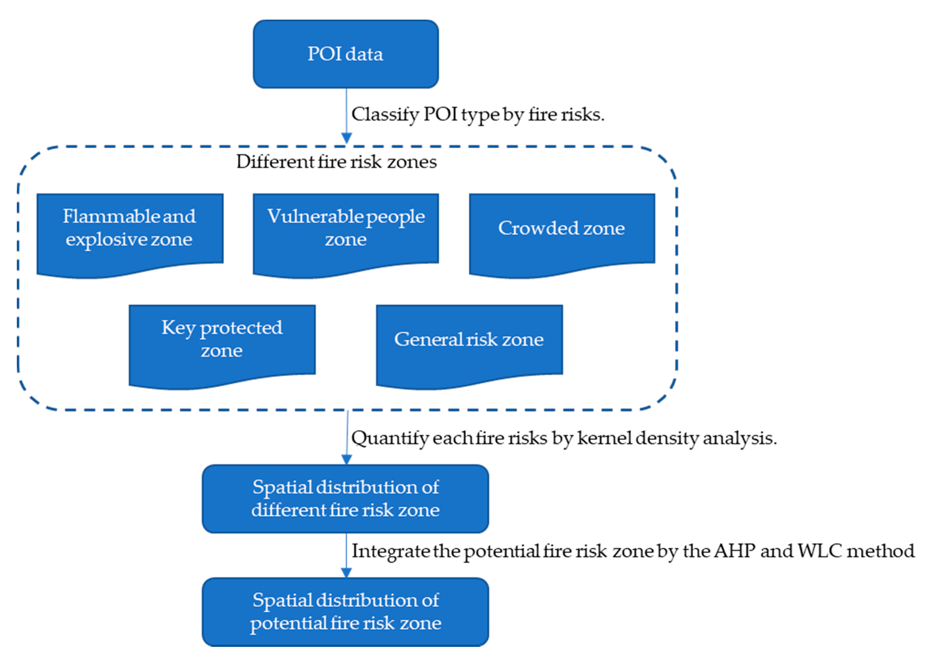
34], which are available in the form of point-of-interest (POI) data, Baidu Maps, and other data formats. POI data are point data of real geographical entities and include attribute information such as longitude and latitude, address, and name. POI data are very important for city managers and emergency responders to make strategic and operational decisions [
30,
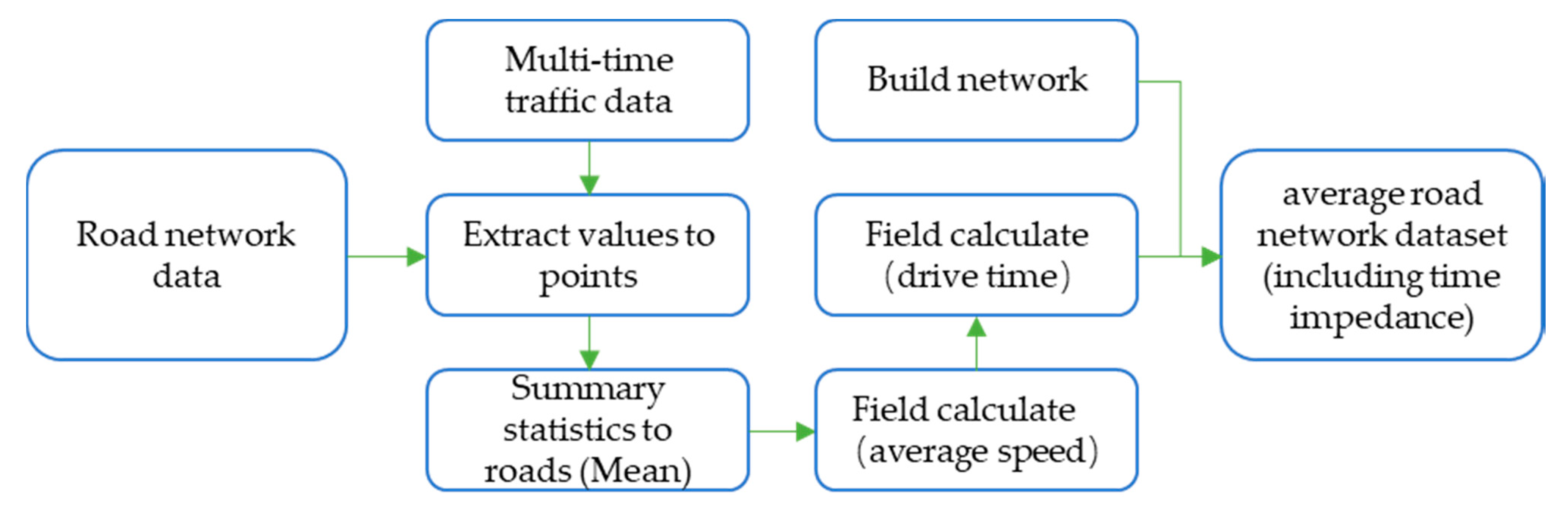
35]. POI data have the advantage of fast update speed, detailed content, a large amount of data, wide coverage, and low acquisition cost. Therefore, this study uses POI data to assess urban fire risk and thereby address the problem mentioned above of a lack of detailed information on building construction. Finally, Baidu Maps are used to obtain traffic network data to address the third problem mentioned above regarding the transport network.
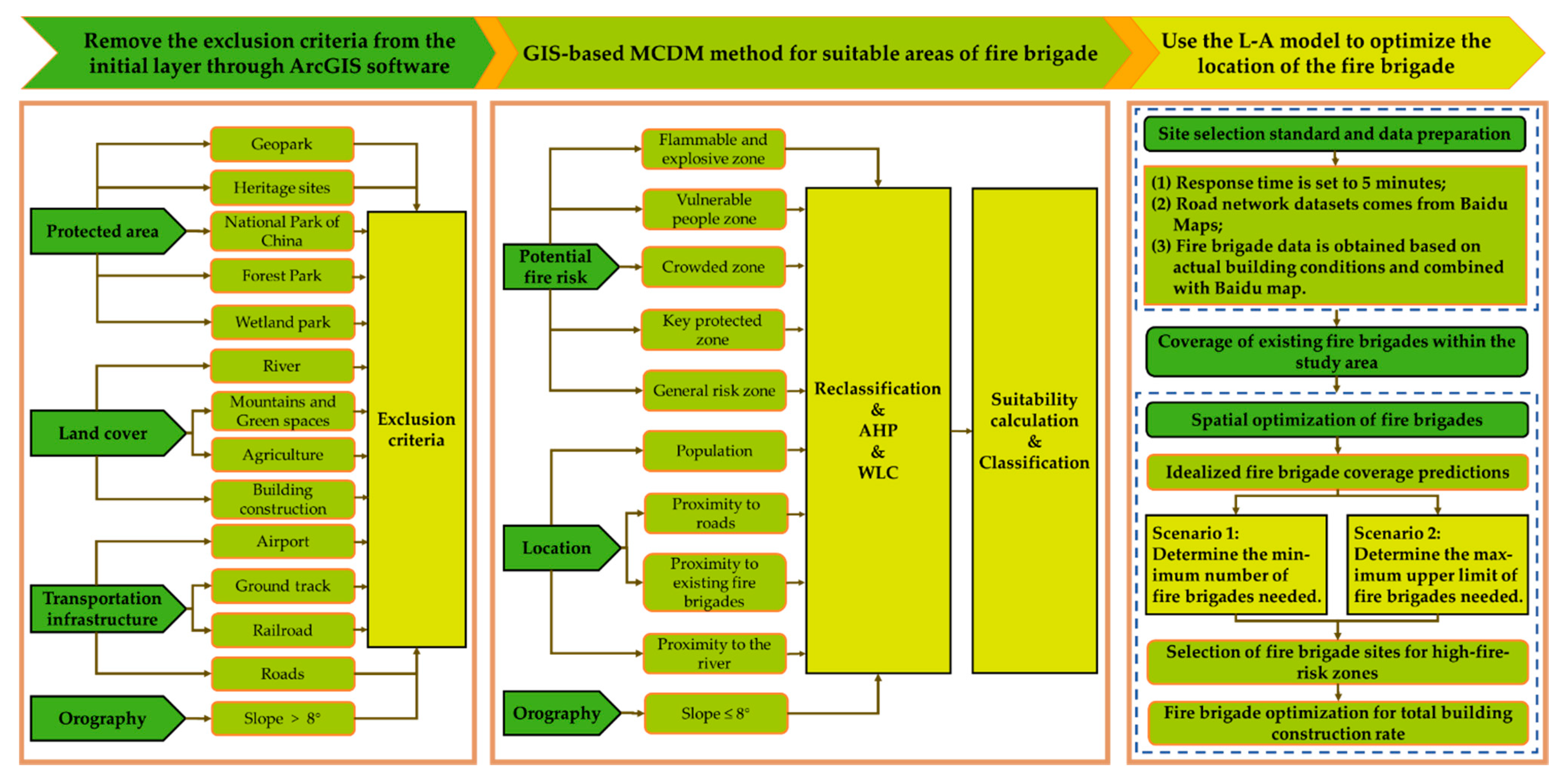
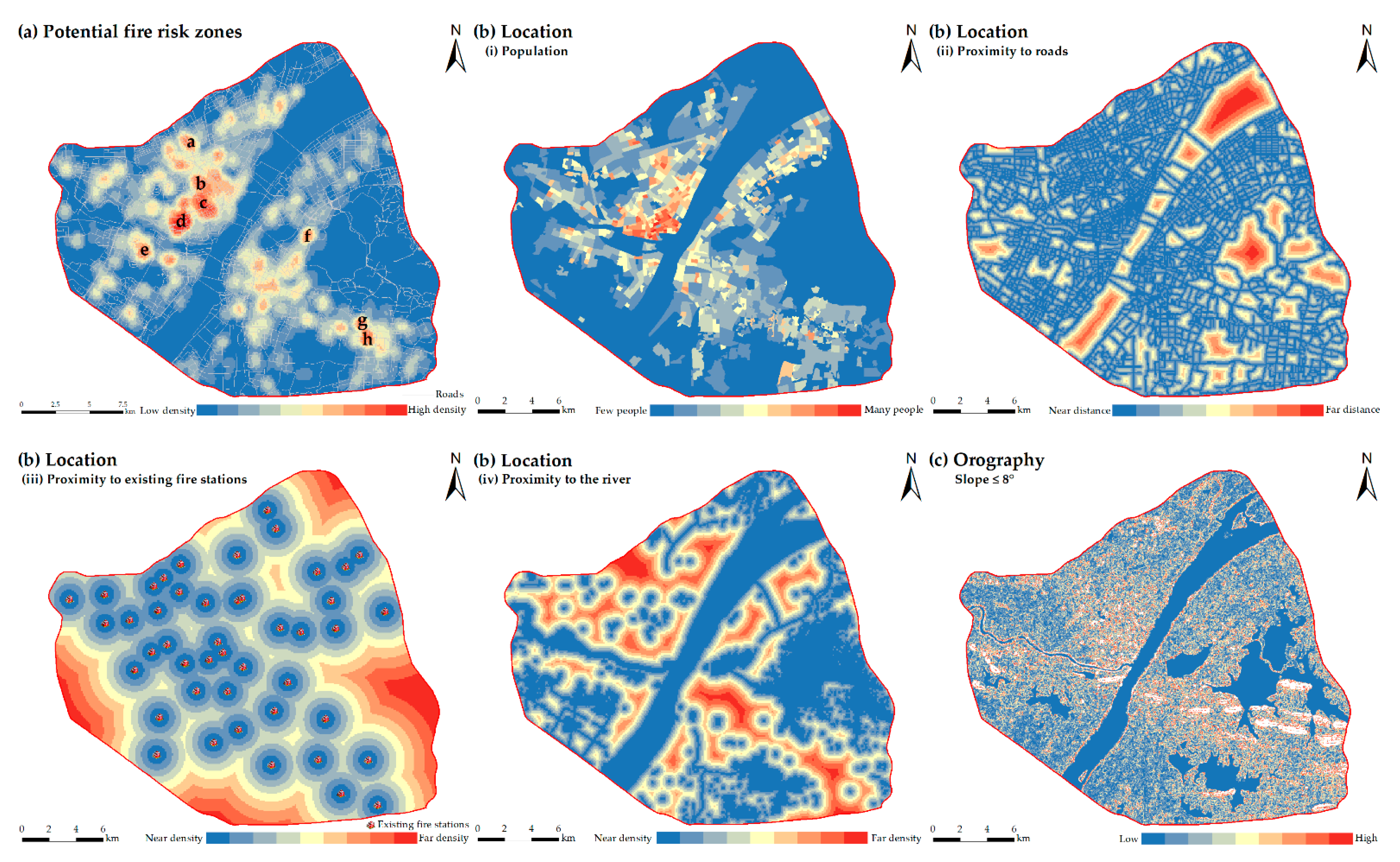
In this context, a method combining GISs with multi-criterion decision-making (MCDM) is proposed to identify the most suitable zones for fire brigades. This research aims to solve the limitations of the existing L-A model by integrating three sets of information obtained from emerging geospatial datasets: (i) land-cover data, (ii) potential fire risk levels from POI data, and (iii) average traffic data from Baidu Maps that are accurate to the road scale.
This article is organized as follows:
Section 2 outlines the study area and describes the proposed methods, and the experimental results are analyzed in
Section 3.
Section 4 provides the discussion. Finally,
Section 5 presents the conclusions.
4. Discussion
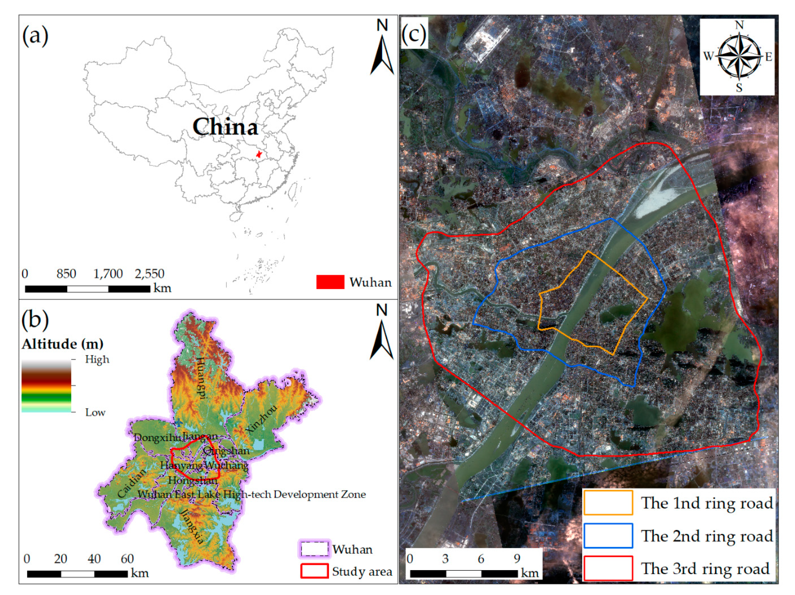
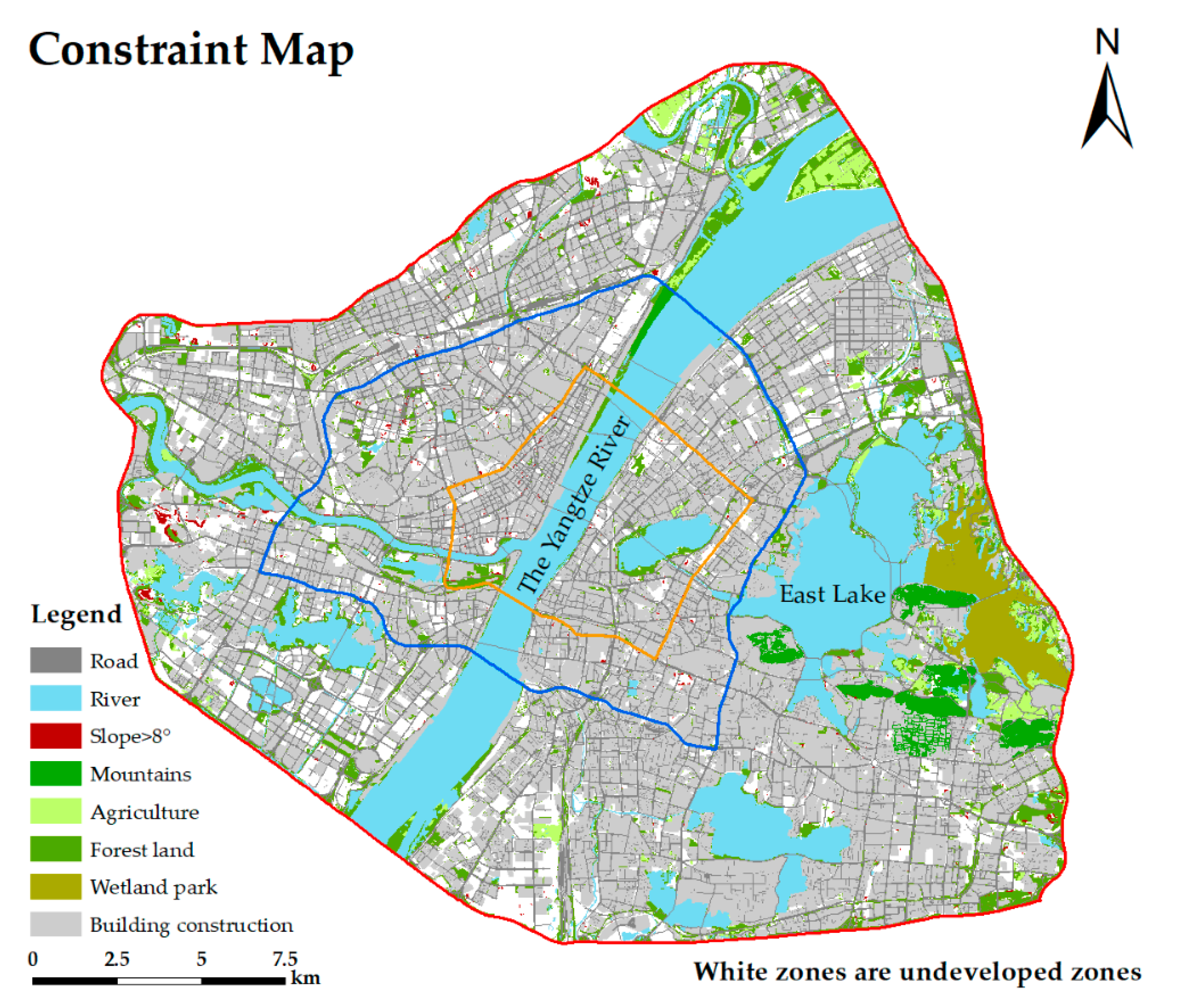
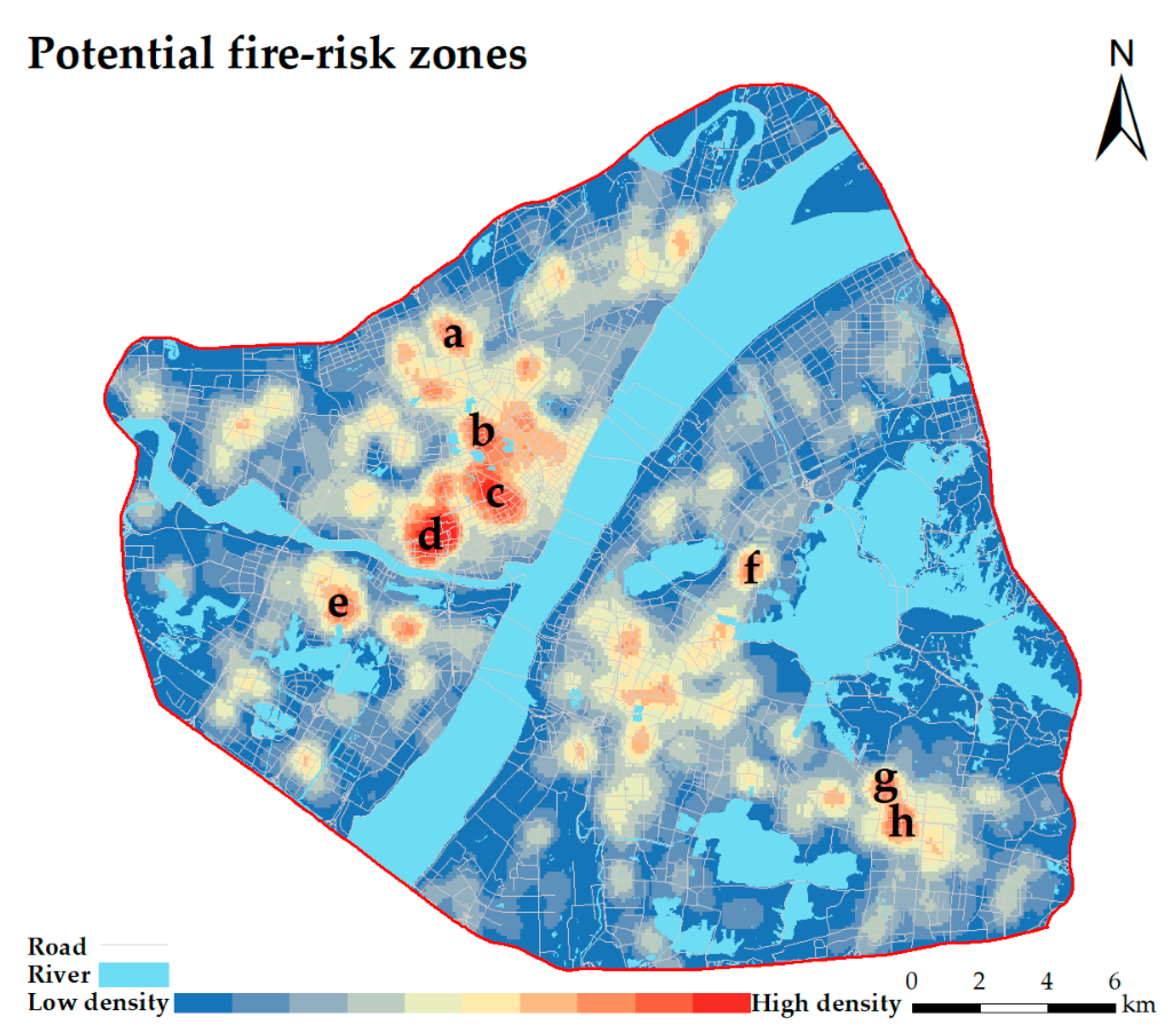
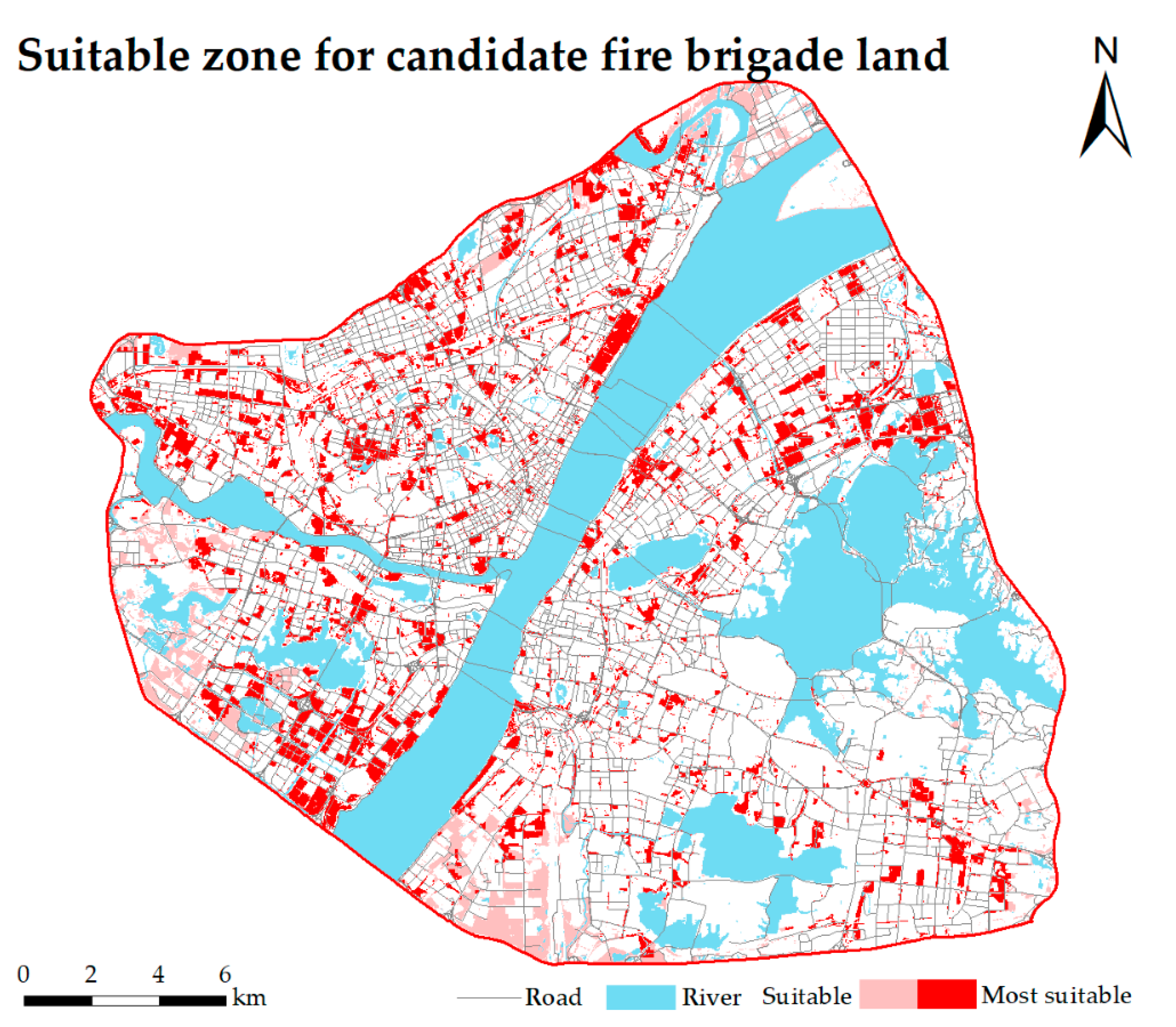
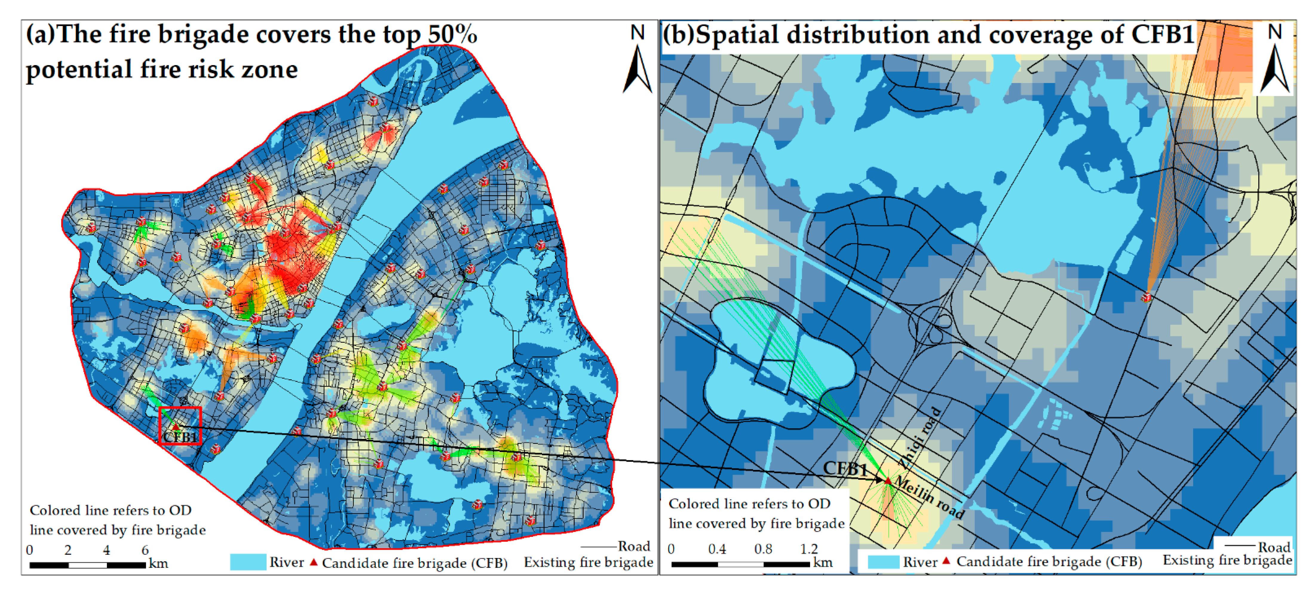
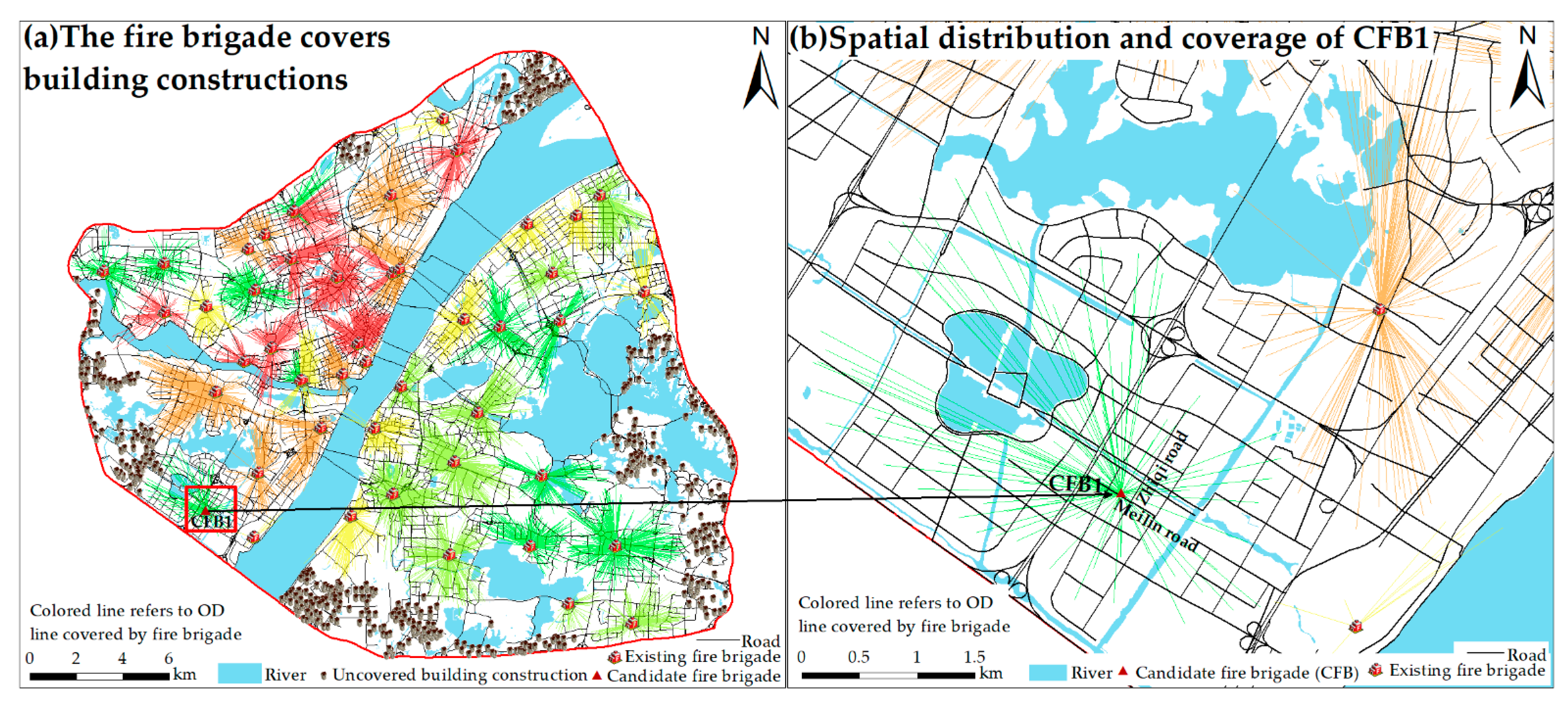
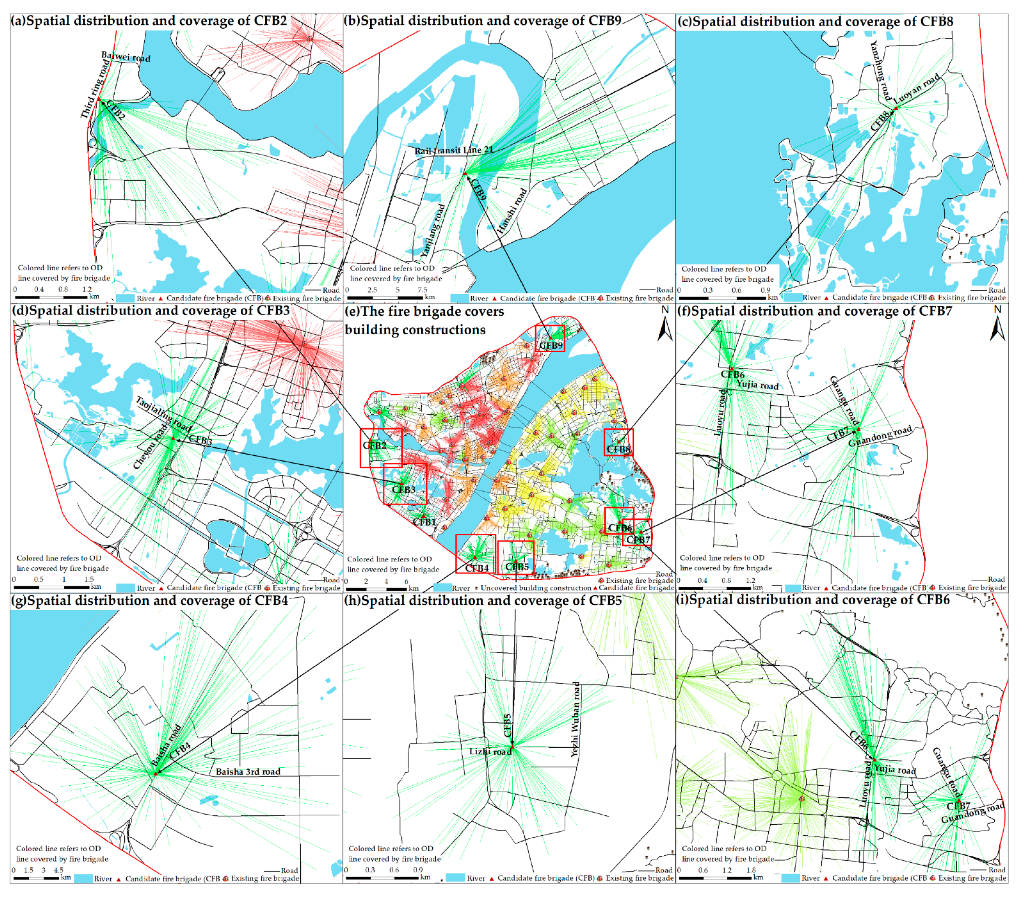
As China experiences rapid industrialization and urbanization, urban safety has become an important problem that concerns many people, so a reasoned placement of urban fire brigades is very important. In cities, land-use, building functions, and risk status often vary, so there may be a lack of assessment of the risk profile, making fire brigade placement irrational. For city managers and emergency responders, the challenge of prevention can be daunting. As one of the biggest cities in China, Wuhan has the same urban security problems that most cities face. Therefore, Wuhan is a good representative region for use as a research area in this article. Due to the constraints imposed by the existing buildings in the city, areas that are not suitable for building fire brigades are excluded. In addition, considering the POI has high timeliness and wide coverage in terms of geographic location, we demonstrate herein the potential and value of POI in urban fire-risk assessment. At the same time, with the development of Internet technology, the spatiotemporal road network data cover most cities. Therefore, the framework of this work can be transferred to other types of cities.
However, cities are giant, complex, and dynamic systems, which means some problems remain unsolved. First, POI data are abstract points without building area, building volume, and building shape, so they cannot reflect the size of the building, which may affect the estimation accuracy of firefighting areas. Second, the same type of POI data may indicate a different fire intensity. For example, different materials processed inside a chemical plant may cause a different fire risk. Such detailed information is difficult to obtain. Third, the methods and frameworks proposed in this article are implemented in different fields of interest, and the impact of different facility locations may need to consider different factors and local characteristics. For example, PV and CSP site selection needs to combine the effects of light intensity and light time [
56]. Finally, a comprehensive site selection of the fire brigade needs to be conducted based on historical fire data. We believe that with the development of information and communication technology, the emergence of new data will further aid in solving these problems.


