Article

Mapping the Accessibility of Medical Facilities of Wuhan during the COVID-19 Pandemic

1
Department of Landscape Architecture, College of Landscape Architecture, Nanjing Forestry University, Nanjing 210037, China
2
Department of Geography, University of Georgia, Athens, GA 30602, USA
*
Author to whom correspondence should be addressed.
ISPRS Int. J. Geo-Inf. 2021, 10(5), 318; https://doi.org/10.3390/ijgi10050318
Submission received: 12 March 2021 / Revised: 22 April 2021 / Accepted: 2 May 2021 / Published: 8 May 2021
(This article belongs to the Special Issue Geo-Information Applications in Active Mobility and Health in Cities)

Abstract

:
In December 2019, the coronavirus disease 2019 (COVID-19) pandemic attacked Wuhan, China. The city government soon strictly locked down the city, implemented a hierarchical diagnosis and treatment system, and took a series of unprecedented pharmaceutical and non-pharmaceutical measures. The residents’ access to the medical resources and the consequently potential demand–supply tension may determine effective diagnosis and treatment, for which travel distance and time are key indicators. Using the Application Programming Interface (API) of Baidu Map, we estimated the travel distance and time from communities to the medical facilities capable of treating COVID-19 patients, and we identified the service areas of those facilities as well. The results showed significant differences in service areas and potential loading across medical facilities. The accessibility of medical facilities in the peripheral areas was inferior to those in the central areas; there was spatial inequality of medical resources within and across districts; the amount of community healthcare centers was insufficient; some communities were underserved regarding walking distance; some medical facilities could be potentially overloaded. This study provides reference, in the context of Wuhan, for understanding the spatial aspect of medical resources and residents’ relevant mobility under the emergency regulation, and re-examining the coordination of emergency to improve future planning and utilization of medical facilities at various levels. The approach can facilitate policymakers to assess potential loading of medical facilities, identify low-accessibility areas, and deploy new medical facilities. It also implies that the accessibility analysis can be rapid and relevant even only with open-source data.

1. Introduction

In December 2019, the pandemic of coronavirus disease 2019 (COVID-19) attacked Wuhan city, Hubei Province, China [1]. As of now, COVID-19 has spread across the globe. Approximately 155,665,214 cases have been confirmed with 3,250,648 deaths all around the world as of 6 May 2021. Since the outbreak, local and state governments in China have taken a series of unprecedented measures to respond to the pandemic. In Wuhan, strategies had been strictly implemented including lockdown not only of the public spaces [2,3] but also communities (Xiao-qu) and sometimes even apartments until 8 April 2020 [4]. Accompanied by motor vehicle restriction in the urban area of Wuhan [5], a hierarchical diagnosis and treatment system was strictly implemented for the allocation of the pandemic-related medical facilities, including the fever clinics, designated hospitals, mobile cabin hospitals (Fang-cang Shelter Hospital), and so on [6,7]. At the same time, all the patients and people were required to follow the principle of “no cross-district treatment and visiting the pandemic-related medical facilities nearby [8]”. Both the lockdown and hospital exclusively designated at the city level were relatively scarce in the history of Chinese urban management and public health. In this way, spatial distribution and the accessibility of medical facilities framed access and potential service affordance for the residents of the whole city, which consequently influenced the prevention and treatment of COVID-19 in Wuhan city.
Within the notion of Social Determinants of Health (SDOH), Donabedian (1973), Penchansky, and Thomas (1981) provided an insightful view of the concept of “health access” and how it intersected with the SDOH. The “Five A’s of Access” were described in their work, and they were affordability, availability, accessibility, accommodation, and acceptability [9,10]. The spatial disparity of medical facilities has been known as a critical reason for unequal access to health outcomes [11]. Previous studies have proved that effective treatments or the prevention of some diseases were related to the accessibility of medical facilities, such as preventive health services [12,13], maternity care services [14,15], surgical cares [16], prehospital cares [17], emergency hospitals [18], and so on. Factors that influence accessibility, including distance from residences to medical facilities, road conditions, and traffic modes, are usually more adverse in developing cities or rural areas.
Various metrics have been adopted for evaluating the accessibility of medical facilities and resources, which can be classified into two categories according to different emphases. The first category emphasizes on the visualization of service areas of medical facilities, using distance and time as metrics [19]. Euclidean distance was a conventional metric to measure the service area of facilities [20,21]. For simple calculation and pellucidity, this method is still used in some planning, designs, and research, despite a probable counter fact that pedestrians and cars seldomly travel in straight lines. After that, delineating service area with consideration of actual road network, by using the Geographical Information System (GIS), gradually gained momentum as an improved approach with better precision [22]. However, the collection and preparation of road network and traffic conditions, if not vulnerable to acquisition from the authorities, are time-consuming and taxing [23,24,25]. In recent years, with the increasing availability of open-source data, more and more researchers have used Application Programming Interface (API) of online mapping services, such as the Google Map API and Baidu Map API, to acquire the estimated travel distance and time for detecting service areas of various travel modes [26]. Compared to the desktop GIS network analysis, online map APIs usually have the benefits of open data accessed, real time, and free [12,26].
The second category, based on service area delineation, emphasizes the relation between the supply and demand for medical facilities in a certain threshold. In early studies, the population-to-provider ratio (PPR) as a traditional indicator has been favored among researchers and policymakers over time for its straightforward and translucent implications for practice [21]. However, due to the neglect of cross-border healthcare-seeking behavior, using PPR to calculate accessibility sometimes cannot be admitted as an effective method [27,28]. More complicated measurements, such as the gravity model, have emerged and been applied in many empirical pieces of research [29]. Kernel density estimation (KDE) and two-step floating catchment area (2SFCA) method, as variants of the gravity model, are widely used, with the latter receiving more attention for its better precision [21,30,31].
Methods of the two categories are emphasized by various studies, depending on the dimensions, phases, and data availability. Recently, a noticeable trend is that more types of data, such as data based on location-based service (LBS), have been combined with accessibility analysis to correlate actual population flow and distance decay effect, etc. [26,32]
Due to the COVID-19 pandemic, spatial accessibility assessments of COVID-19 patients to healthcare facilities were studied by researchers [33,34,35]. In these studies, it was believed that people living in areas of dense population or on the margins were disproportionately disadvantaged in terms of the access to medical facilities and healthcare [36,37]. There was also evidence suggesting that the unevenness of healthcare resources in China and other countries partly explain the high mortality rates in some areas even with a low number of confirmed COVID-19 cases [38]. For Wuhan, researchers had previously found that communities in the central urban areas had higher car accessibility to medical facilities, and car accessibility in half of the communities was inappropriate for their population size [39].
During the lockdown in Wuhan from 23 January to 8 April, 2020, the strict motor vehicle restriction and hierarchical diagnosis within designated nearby facilities imposed an unprecedented transportation situation to the residents and healthcare providers. The consequently accessibility, which is critical understanding the residents’ situation, may change significantly. The goal of this paper is to measure the real-time accessibility of available travel modes by using the Baidu Map API, and identify underserved areas and discern spatial disparity of facilities during the emergency lockdown of Wuhan. The accessibility analysis of medical facilities was based on the motor vehicle restriction and bottom–up hierarchical diagnosis and treatment system, which is unprecedented in the history of Chinese urban management and public health. This approach can be transferable to other cities in China or other countries, according to their local pandemic control policy.

2. Methodology

Based on the streamlined procedures of treatment and supply purchase issued by the Wuhan Government and Wuhan Health Commission, this study estimated travel distance and time from communities to the pandemic-related medical facilities in the urban area of Wuhan, by using the Baidu Map API, and it identified service areas and population, as well as the potential capacities of those medical facilities by using the PPR-related indices.

2.1. Study Area and Objects

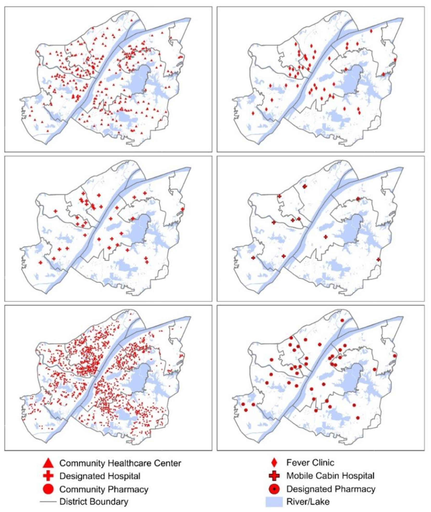
The study area covers the urban area of Wuhan, including eight districts as of Jiang’an District (partial), Jianghan District, Qiaokou District, Hanyang District, Caidian District (partial), Qingshan District, Wuchang District, and Hongshan District (partial), which consists of 101 sub-districts (Jie-dao). With area of 695.98 km2, this study area is the geographical and economic center of Wuhan city. The population within this area accounts for 56.3% of the total population in Wuhan (Figure 1). According to the Wuhan Government and Wuhan Health Commission, the pandemic-related medical facilities include the community healthcare centers, fever clinics, designated hospitals (treat and isolate severe COVID-19 patients), mobile cabin hospitals (treat and isolate mild COVID-19 patients), community pharmacies, and designated pharmacies (prescribe prescription medicines to non-COVID-19 patients) (Figure 2).

2.2. Method and Indices

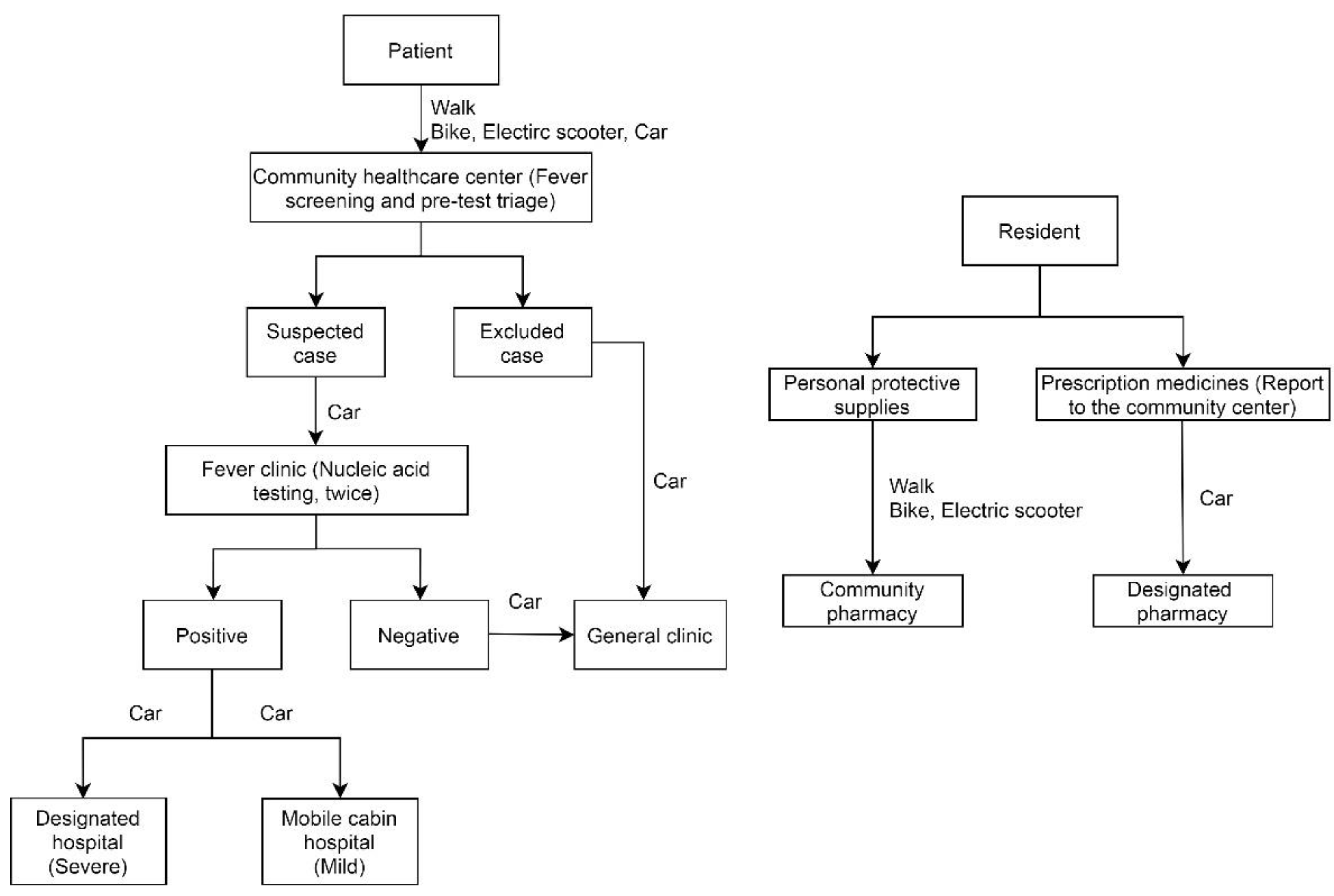
According to the Wuhan Government and Wuhan Health Commission, motor vehicle restriction was implemented in the urban area from 23 January to 8 April, 2020. Except for authority-permitted transport vehicles and buses, motor vehicles (not include bikes and electric scooters) shall be prohibited from driving. Each community was equipped with several emergency vehicles [5]. The Wuhan Health Commission adopted a bottom–up hierarchical diagnosis and treatment system. All the COVID-19 patients were required to follow the rule of nearby treating, i.e., “seeking no cross-district medical treatment and visiting the pandemic-related medical facilities nearby [8]”. With these strict regulations, it is relatively reliable to estimate the residents’ travel orientation-destination related to the pandemic. Before residents visited the fever clinics, they should walk to the nearby community healthcare centers firstly for fever screening and pre-test triage. If the community healthcare center was too far to walk, the residents could choose to bike or take a car provided by the community. Patients with suspicious COVID-19 symptoms would be sent by emergency vehicles to the fever clinics for further diagnosis. Once confirmed infection of COVID-19, the severe-symptom patients would be transported to the designated hospitals, while the mild-symptom patients would be transported to the mobile cabin hospitals. Residents with chronic diseases could report to the community center, who would deliver requested prescription medicines purchased from the designated pharmacies. The rest residents, without the above-mentioned conditions, needed to walk or bike to the community pharmacies nearby to pursue personal protective supplies, such as medical masks and gloves (Figure 3).
Based on the medical treatment process, we built a geo-spatial database to identify service areas and population, and potential capacities of the pandemic-related medical facilities. The analysis procedure and relevant data are as follows:
  • Combine the official information and online map data, mapping the geographical locations and beds information of the medical facilities relevant to COVID-19;
  • Compile boundaries of all the communities (4076) in the study area of Wuhan;
  • Scrape travel distance and time of various travel modes from communities to community healthcare centers, from community healthcare centers to fever clinics, from fever clinics to design hospitals and mobile cabin hospitals, from communities to community pharmacies and designated pharmacies (Figure 3); then, select the shortest-time travel as the presumed one. From communities to community healthcare centers and community pharmacies, the selections are based on walking mode, while for the others, the selections are based on driving mode (with the Baidu Map API from February to March, 2020) [41];
  • Following the treatment procedure shown in Figure 3, identify the amount of communities and service areas each pandemic-related medical facility can serve; then, overlay the medical facilities’ service areas on the community population layer to estimate the potential capacities of those medical facilities. Table 1 shows the relevant indices, which are PPR-related. Due to ‘the lockdown and no cross-district medical treatment policy’, these indices can ignore their disadvantages of neglecting the cross-border healthcare-seeking behavior and take advantage of their merits of easy understanding and simple calculation [21,27,28].
Software packages and tools of Python 3.7, Baidu Map API, and ArcGIS 10.6 were used for data collection and processing, mapping, and spatial analyzing.

3. Results

3.1. Service Areas and Potential Capacities of the COVID-19 Medical Facilities

3.1.1. Service Areas and Population of the Community Healthcare Centers

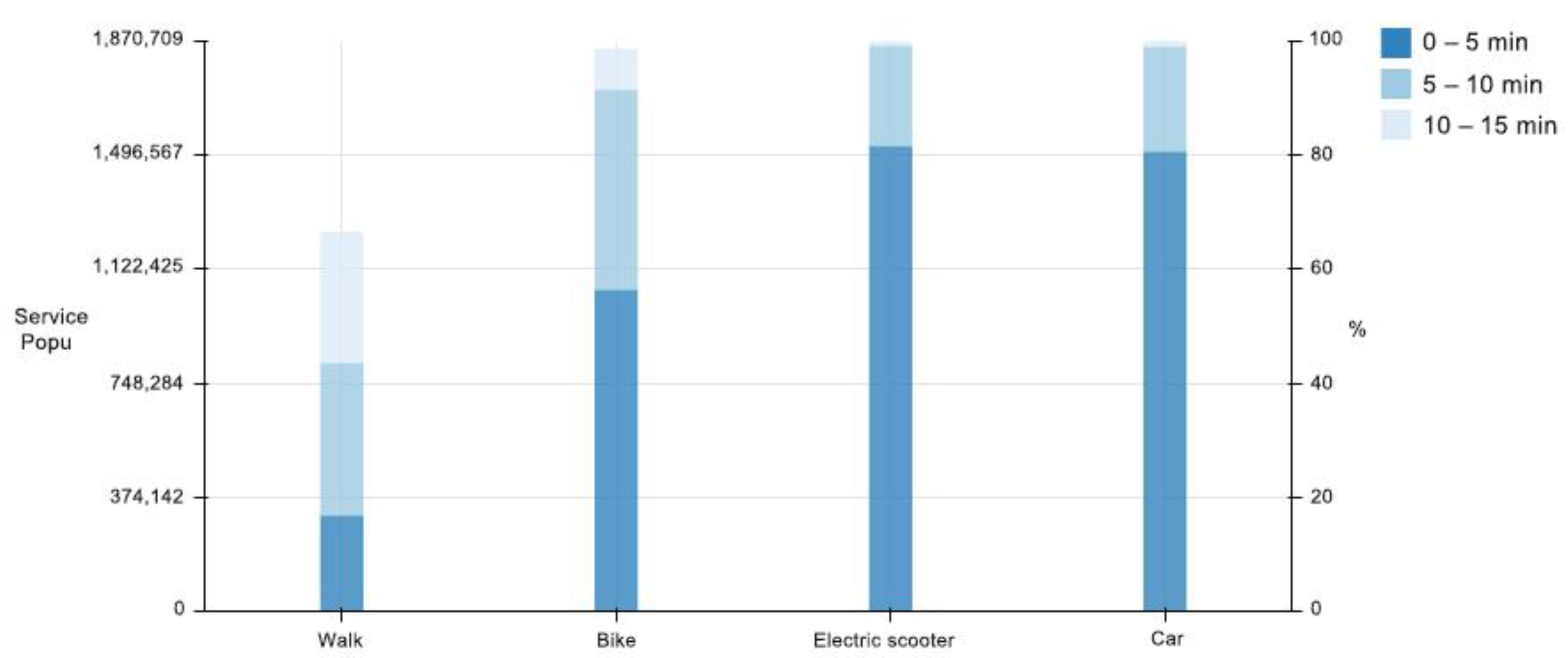
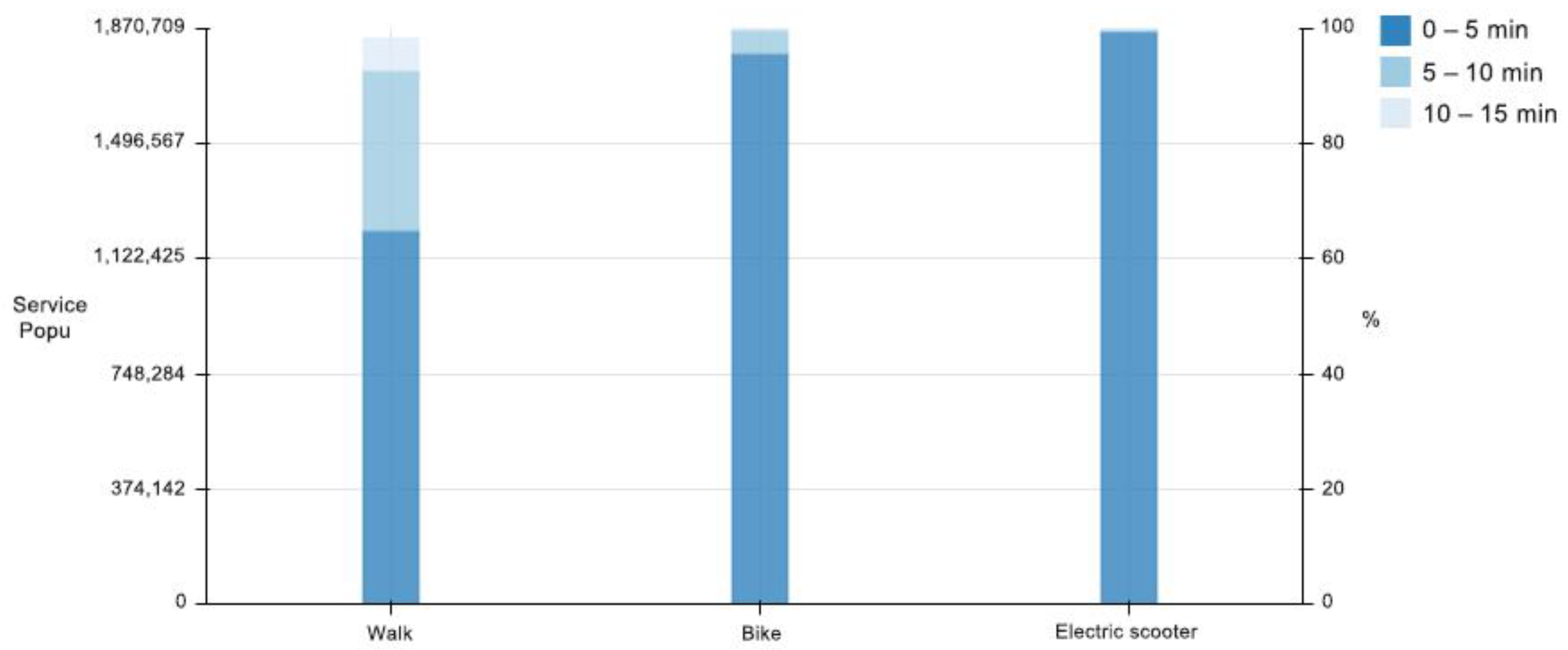
There were 16.8%, 43.6%, and 66.4% of residents in the study area could walk to the nearest community healthcare centers within 5 min, 10 min, and 15 min. For bike riders, the percentages were 56.4%, 91.5%, and 98.6% for the same time thresholds. Electric scooter riders (electric scooter is a common mode of transportation in China) and car passengers had much better accessibility, of which over 99.0% were within 10 min to the nearest community healthcare centers (Figure 4).
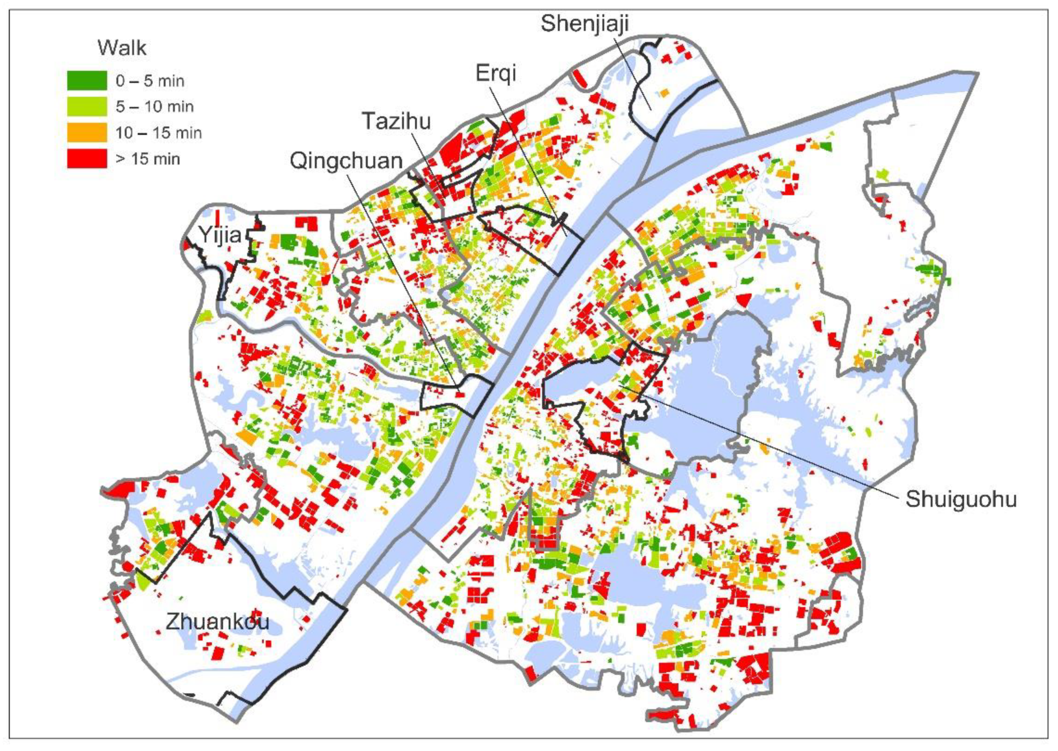
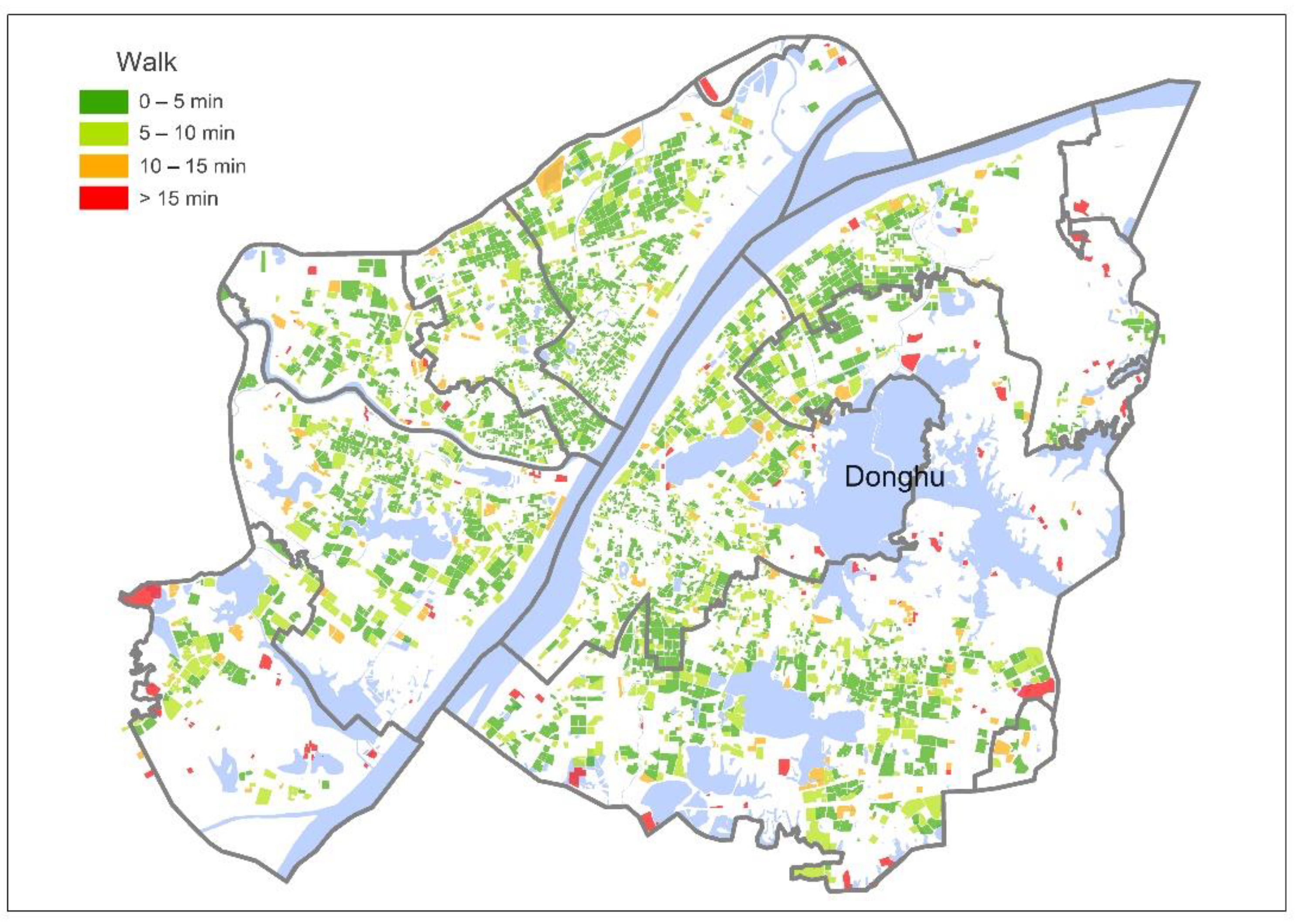
The average and median walking time from communities to the nearby community healthcare centers were 12.9 min and 10.9 min, respectively. Given a 15-min walking distance, the threshold to differentiate well-served or underserved areas, 31.9% of communities were beyond 15-min walking distance to the nearest community healthcare centers, which may be inconvenient for residents, especially for the elderly, disabled, and those with severe symptoms. At the district level, more than 50% of the communities in Caidian District were underserved (62.7%). At the sub-district level, over 50% of the communities in 19 sub-districts were underserved. Four sub-districts of Zhuankou, Erqi, Tazihu, and Shuiguohu had as high as 70–80% of the communities underserved. Over 80% communities in Qingchuan, Shenjiaji, and Yijia sub-districts were underserved (Figure 5).

3.1.2. Service Areas and Population of the Fever Clinics

At the city level, the average service area of fever clinics was 3.0 km2. The average and median service population of all the 44 fever clinics were 42,303 and 34,180, respectively. Among those, 33 fever clinics (and 75.0%) had the service population of ≤50,000; 7 fever clinics (and 15.9%) had the service population of 50,001 to 100,000; 3 fever clinics (and 6.8%) had the service population of 100,001 to 150,000; and 1 fever clinic (and 2.2%) had the service population >150,000. Four fever clinics of Fuyou, Hankou, Disan, and Feike had the greatest service population of 205,843, 122,514, 117,590, and 113,105 (Figure 6). At the district level, Hongshan District had the largest average service population (98,580), while Qingshan District had the smallest one (13,199). The service population of fever clinics in peripheral areas was inadequate compared with those in central areas, especially in the Jiang’an, Jianghan, Qiaokou, and Wuchang Districts (Figure 7).

3.1.3. Service Areas and Population–Hospital Bed Ratios of the Designated Hospitals

At the city level, the average service area of designated hospitals was 3.8 km2. The average and median population–hospital bed ratios, defined as the ratio between the total population and total number of hospital beds, were 149 and 115, respectively. The larger the value was, the more competitive for the hospital beds. Out of the 35 designated hospitals, the population–hospital bed ratios were as follows: 28 hospitals (and 80.0%), ≤200; 5 hospitals (and 14.3%), 201 to 400; 1 hospital (and 2.9%), 401 to 600; and 1 hospital (and 2.9%), >600. The Liuqier Designated Hospital (827) and Hankou Designated Hospital (406) ranked the most heavily burdened (Figure 8). At the district level, Hongshan District had the highest population-hospital bed ratio (360), while the Caidian District had the lowest one (53). The results showed that the population–hospital bed ratios of designated hospitals were spatially inequality, especially in Jiang’an and Hongshan Districts (Figure 9).

3.1.4. Service Areas and Population–Hospital Bed Ratios of the Mobile Cabin Hospitals

At the city level, the average service area of mobile cabin hospitals was 12.1 km2. The average and median population–hospital bed ratios served by each mobile cabin hospitals were 238 and 157, respectively. Out of the 11 mobile cabin hospitals, 8 hospitals (and 72.7%), ≤200; 1 hospital (and 9.1%), 201 to 400; 1 hospital (and 9.1%), 401 to 600; and 1 hospital (and 9.1%), >600. The Wuti Mobile Cabin Hospital (807) ranked the most heavily burdened (Figure 10). At the district level, there was only one mobile cabin hospital in Qiaokou District, with the highest population–hospital bed ratio of 807, while also only one mobile cabin hospital was deployed in Caidian District, with the lowest population–hospital bed ratio of 39. There was a spatial inequality of mobile cabin hospitals across districts (Figure 11).

3.2. Service Areas and Potential Capacities of the Pharmacies Related to Residents

3.2.1. Service Areas and Population of the Community Pharmacies

As shown in Figure 12, about 64.9%, 92.7%, and 98.3% of residents in the study area could walk to the nearest community pharmacies within 5, 10, and 15 min. About 95.7%, 99.8%, and 99.9% of residents could ride to the nearest community pharmacies within the same time thresholds. Over 99.0% electric scooter riders could reach the nearest community pharmacies within 5 min.
The average and median durations from communities to the community pharmacies of the walking mode were 4.9 min and 3.8 min, respectively. To purchase personal protective supplies, the most common way people travel to community pharmacies is walking. Residents in almost all communities (97.1%) could reach the nearest community pharmacies within a 15-min walk, except for a few communities around the Donghu (Figure 13).

3.2.2. Service Areas and Population of the Designated Pharmacies

At the city level, the average service area of the designated pharmacies was 3.4 km2. The average and median service population of designated pharmacies were 49,070 and 40,726, respectively. Out of the 38 designated pharmacies, 21 pharmacies (and 55.3%), had the service population of ≤50,000; 12 pharmacies (and 31.6%), 50,001 to 100,000; 4 pharmacies (and 10.5%), 100,001 to 150,000; and 1 pharmacy (and 2.6%), >150,000. The Laobaixing Designated Pharmacy potentially served the largest population (165,802) (Figure 14). At the district level, the average service population of pharmacies in Wuchang District ranked the most (62,634), while pharmacies in Caidian District averagely served the smallest population (14,394). The results showed there were significant differences of potential service population across the designated pharmacies, which may present challenges to some residents, especially in Qiaokou District (Figure 15).

4. Discussion

Until the mid-term shutdown for the COVID-19 pandemic in Wuhan (25 February, 2020), there were 25,220 hospital beds deployed in the study area, which was equivalent to 430 hospital beds per thousand persons, which theoretically could accommodate the treatment and isolation of the patients with severe and mild symptoms [42,43]. However, the spatially uneven distribution of medical facilities may aggravate the complexity and uncertainty of the healthcare system’s performance, especially during this unprecedented pandemic. Detecting the accessibility pattern would be basic for effective emergency management of adapting healthcare policies and infrastructures, even as a hindsight. Some findings and suggestions are as follows.
First, the uneven distribution of medical resources probably presented challenges for healthcare service in the study area of Wuhan, particularly during the pandemic, which is presumably ubiquitous in many cities. There were palpable disparities of the distribution of medical resources across the communities, sub-districts, and districts. Medical facilities were less accessible in the peripheral areas of Wuhan, which have more deprived dwellers than in the central areas. It suggests that increasing medical resources in certain areas, or allowing cross-district inpatient when medical resources were available in other districts, may enhance the performance of medical resources and alleviate the disparity. In the case of residents walking from communities to the nearby community health centers, given cross-district treatment adopted rather than no cross-district regulation, the average walking time would drop from 12.9 min to 12.0 min, with more communities (from 68.1% to 70.8%) within a 15-min walking distance to the community health centers.
Most communities (99.9%) in the study area of Wuhan were within 15-min electric scooter riding or car driving distance to the community healthcare centers, where the diagnosis and consequent measures were taken. Nevertheless, walking should be prioritized as the primary transportation mode since motor vehicles were restricted during the lockdown. Given a 15-min walking distance as a threshold of accessibility, many communities in Wuhan were underserved (31.9%). In these communities, people would be more disadvantaged, especially those with low mobility, such as the older adults, disabled, and COVID-19 patients with severe symptoms. Therefore, more community healthcare centers should be deployed to improve the residents’ accessibility for timely diagnosis and treatment.
In Wuhan, communities and community healthcare centers played important roles in the COVID-19 prevention and intervention, including fever screening, pre-test triage, and uniform distribution of medical materials. As a basic spatial unit of the city, the community’s function relies on inter—as well as intra—area performance, both of which are integral for the residents’ adaption to the pandemic crisis [44]. In 2016, the State Council of China had already advocated “Building a 15-min Community Life Circle” [45]. Such policy aimed to deploy essential public services and facilities within residents’ daily activity space. Since then, many cities in China have kick-started the implementation of the Community Life Circle. It is evident that public health issues, especially in pandemic emergencies, should be reconsidered and receive more attention in urban planning.
Second, no cross-district treatment controlled unpredictable patient flow, which otherwise would address overcrowding and even turmoil. During the pandemic, a three-tier system of community healthcare centers, fever clinics, and hospitals for COVID-19 patients had been developed in Wuhan to avoid patients’ gathering in several popular hospitals [46]. While this measure appeared to be effective generally, we should be alert that some healthcare centers and hospitals may confront overloading when the service population substantially exceeded their capacity.
Before the hierarchical diagnosis and treatment system was implemented, some popular hospitals did witness overcrowding with patients. One of the reasons can be attributed to the strong inclination of many residents to visit the prestigious hospitals, which was common for a long time in China. It is only possible for the residents to prioritize community healthcare where quality service is persistently tangible in daily life. One premise is improving the service capacity of community healthcare centers by deploying more upgraded facilities and hiring more medical professionals. Such directive and policy can reinforce the hierarchical diagnosis and treatment system, which actually had been issued by State Council in 2015 [39,47]. As for this unprecedented emergency, it appeared that a flexible healthcare system that synthetically accommodates the vertical flow of resources and personals would be beneficial.
Third, this accessibility analysis, tailored according to the motor vehicle restriction and hierarchical diagnosis and treatment system, provides a reference for non-pharmaceutical interventions [3]. The pandemic control policy made it relatively explicit to predict capacities of the medical facilities, which is valuable for optimizing resource allocation. This study, despite its retrospectively perspective, demonstrates that an accessibility analysis may detect the location of underserved areas, and overloaded hospitals and pharmacies, identifying where pharmaceutical and non-pharmaceutical intervention should be prioritized. Such prediction would help the emergency coordinators and policymakers foresee the hotspots and prepare resources in advance, especially for the underserved communities at the city scale.
There are several limitations in this study. First, this study relied mainly upon the Baidu Map for accessibility analysis, which means all the medical facility POIs (Points of Interest), community boundaries, and travel distance and time were derived from this online map. After scraping community boundaries, we, using the Baidu Map and Street View Map, checked and supplemented them one by one, but it does not necessarily mean all the communities were covered. Therefore, communities without complete boundary information, communities ignored in the Baidu Map, and residents living in the areas not defined or recorded in the Baidu Map were not all included in this study. Second, demographic data, medical facilities, resources, transportations, and more, from the authorities’ sources are often insufficient or inaccessible for researchers in a timely manner, for which we had to resort to the Baidu Map and published studies. The population density data in this study was of 2010, which may cause some bias of the capacity estimation. We assumed the change of population between 2010 and 2020, which is definitely increasing, would be spatially consistent throughout the city. Such assumption, probably the most feasible and reliable way for ordinary researchers, at least would not undermine the method itself. Similarly, we had limited information, such as hospital beds from official webpages and news. We did not have the data of the waiting time for treatment, consultation rate of fever clinics, and deployment of doctors, staff, and medical instruments, although we knew these resources were integral and critical for the diagnosis and treatment. Third, we could not run a correlation analysis between accessibility and health outcomes such as infection rates, diagnosis efficacy, and mental health, because no such data were publically available at the community level. Fourth, this study discussed the ideal state under the official directive of lockdown the whole city. However, the real situation, such as motor vehicle restriction and no cross-district treatment policy, would be adapted to the pandemic situation in Wuhan. Even with these limitations, this study implied the emerging strength of utilizing open-source data, remote sensing by researchers, to map the accessibility of medical facility for potential intervention.

5. Conclusions

It is promising to adopt GIS as well as open-source data to assist pandemic monitoring and prevention, as some dashboard projects have presented. In this study, by calling the Baidu Map API to estimate travel distance and time, the authors quickly and accurately identified service areas of the pandemic-related medical facilities based on the hierarchical diagnosis and treatment system. This method is basic and straightforward, which can help policymakers to assess the service areas and potential capacities of medical facilities, determine the siting, and predict demand for hospital beds and medical resources. Through supporting data-based planning, the innovative modelling practice has potential to improve the health and emergency response. This method can be transferable to other cities in China or other countries, according to their local pandemic control policy.

6. Patents

  • Computer Software Copyright: Walking simulation trip generator software (5161030), Copyright Protection Center of China.
  • Computer Software Copyright: Peripheral walking routes extractor software (4353770), Copyright Protection Center of China.
  • Computer Software Copyright: Cycling simulation trip generator software (5161237), Copyright Protection Center of China.
  • Computer Software Copyright: Car simulation trip generator software (5054443), Copyright Protection Center of China.
  • Computer Software Copyright: POI extractor software (5054449), Copyright Protection Center of China.
  • Computer Software Copyright: AOI extractor software (5220045), Copyright Protection Center of China.
  • Computer Software Copyright: Coordinate converter software (5607408), Copyright Protection Center of China.

Author Contributions

Conceptualization, Zhen Xu and Zhenqi Zhou; methodology, Zhen Xu and Zhenqi Zhou; software, Zhenqi Zhou and Shuang Zhou; validation, Zhenqi Zhou, Zhen Xu and Xuan Zhang; formal analysis, Zhenqi Zhou; investigation, Anqi Liu, Zhenqi Zhou and Shuang Zhou; data curation, Shuang Zhou and Zhenqi Zhou; writing—original draft preparation, Zhenqi Zhou, Anqi Liu and Zhen Xu; writing—review and editing, Zhen Xu, Zhenqi Zhou, Lan Mu and Xuan Zhang; visualization, Zhenqi Zhou, Zhen Xu and Lan Mu; supervision, Zhen Xu and Lan Mu; project administration, Zhen Xu; funding acquisition, Zhen Xu. All authors have read and agreed to the published version of the manuscript.

Funding

This research was funded by National Natural Science Foundation China (52078254) and the Priority Academic Program Development of Jiangsu Higher Education Institutions (PAPD).

Institutional Review Board Statement

Not applicable.

Informed Consent Statement

Not applicable.

Data Availability Statement

The datas presented in this study are available on request from the corresponding author.

Conflicts of Interest

The authors declare no conflict of interest.

References

  1. Weekly, C.C.; The Novel Coronavirus Pneumonia Emergency Response Epidemiology Team. Vital surveillances: The epidemiological characteristics of an outbreak of 2019 novel coronavirus diseases (COVID-19)—China, 2020. China CDC Wkly. 2020, 2, 113–122. [Google Scholar] [CrossRef]
  2. Wuhan Government. Notification of Wuhan COVID-19 Prevention and Control Headquarters (No.1). 2020. Available online: http://www.wuhan.gov.cn/zwgk/tzgg/202003/t20200316_972434.shtml (accessed on 23 January 2020).
  3. Lai, S.; Ruktanonchai, N.W.; Zhou, L.; Prosper, O.; Luo, W.; Floyd, J.R.; Wesolowski, A.; Santillana, M.; Zhang, C.; Du, X.; et al. Effect of non-pharmaceutical interventions to contain COVID-19 in China. Nature 2020, 585, 410–413. [Google Scholar] [CrossRef] [PubMed]
  4. Wuhan Government. Notification of Wuhan COVID-19 Prevention and Control Headquarters (No.12). 2020. Available online: http://www.wuhan.gov.cn/zwgk/tzgg/202003/t20200316_972539.shtml (accessed on 11 February 2020).
  5. Wuhan Government. Notification of Wuhan COVID-19 Prevention and Control Headquarters (No.9). 2020. Available online: http://www.wuhan.gov.cn/zwgk/tzgg/202003/t20200316_972460.shtml (accessed on 25 January 2020).
  6. Wuhan Government. Notification of Wuhan COVID-19 Prevention and Control Headquarters (No.7). 2020. Available online: http://www.wuhan.gov.cn/zwgk/tzgg/202003/t20200316_972456.shtml (accessed on 24 January 2020).
  7. Chen, S.; Zhang, Z.; Yang, J.; Wang, J.; Zhai, X.; Bärnighausen, T.; Wang, C. Fangcang shelter hospitals: A novel concept for responding to public health emergencies. Lancet 2020, 395, 1305–1314. [Google Scholar] [CrossRef]
  8. Wuhan Government. Notification of Wuhan COVID-19 Prevention and Control Headquarters (No.11). 2020. Available online: http://www.wuhan.gov.cn/zwgk/tzgg/202003/t20200316_972538.shtml (accessed on 11 February 2020).
  9. Donabedian, A. Aspects of Medical Care Administration: Specifying Requirements for Health Care, 1st ed.; Harvard University Press: Cambridge, MA, USA, 1973. [Google Scholar]
  10. Penchansky, R.; Thomas, J.W. The concept of access: Definition and relationship to consumer satisfaction. Med. Care 1981, 19, 127–140. [Google Scholar] [CrossRef]
  11. Wang, F. Measurement, optimization, and impact of health care accessibility: A methodological review. Ann. Assoc. Am. Geogr. 2012, 102, 1104–1112. [Google Scholar] [CrossRef] [Green Version]
  12. Gu, W.; Wang, X.; McGregor, S.E. Optimization of preventive health care facility locations. Int. J. Health Geogr. 2010, 9, 17. [Google Scholar] [CrossRef] [PubMed] [Green Version]
  13. Zhang, Y.; Berman, O.; Verter, V. The impact of client choice on preventive healthcare facility network design. OR Spectrum 2012, 34, 349–370. [Google Scholar] [CrossRef]
  14. Gage, A.J.; Calixte, M.G. Effects of the physical accessibility of maternal health services on their use in rural Haiti. Pop. Stud. J. Demog. 2006, 60, 271–288. [Google Scholar] [CrossRef] [PubMed]
  15. Kyei, N.N.A.; Campbell, O.M.R.; Gabrysch, S. The influence of distance and level of service provision on antenatal care use in rural Zambia. PLoS ONE 2012, 7, e46475. [Google Scholar] [CrossRef] [Green Version]
  16. Grimes, C.E.; Bowman, K.G.; Dodgion, C.M.; Lavy, C.B.D. Systematic review of barriers to surgical care in low-income and middle-income countries. World J. Surg. 2011, 35, 941–950. [Google Scholar] [CrossRef] [PubMed]
  17. Tansley, G.; Stewart, B.; Zakariah, A.; Boateng, E.; Achena, C.; Lewis, D.; Mock, C. Population-level spatial access to prehospital care by the national ambulance service in Ghana. Prehosp. Emerg. Care 2016, 20, 768–775. [Google Scholar] [CrossRef] [Green Version]
  18. Avdic, D. Improving efficiency or impairing access? Health care consolidation and quality of care: Evidence from emergency hospital closures in Sweden. J. Health Econ. 2016, 48, 44–60. [Google Scholar] [CrossRef]
  19. Aday, L.A.; Andersen, R. A framework for the study of access to medical care. Health Serv. Res. 1974, 9, 208–220. [Google Scholar] [PubMed]
  20. Jones, S.G.; Ashby, A.J.; Momin, S.R.; Naidoo, A. Spatial implications associated with using Euclidean distance measurements and geographic centroid imputation in health care research. Health Serv. Res. 2010, 45, 316–327. [Google Scholar] [CrossRef] [PubMed] [Green Version]
  21. Neutens, T. Accessibility, equity and health care: Review and research directions for transport geographers. J. Transp. Geogr. 2015, 43, 14–27. [Google Scholar] [CrossRef]
  22. Reshadat, S.; Zangeneh, A.; Saeidi, S.; Teimouri, R.; Yigitcanlar, T. Measures of spatial accessibility to health centers: Investigating urban and rural disparities in Kermanshah, Iran. J. Public. Health 2019, 27, 519–529. [Google Scholar] [CrossRef]
  23. Wang, F.; Xu, Y. Estimating O-D travel time matrix by Google Maps API: Implementation, advantages, and implications. Ann. GIS 2011, 17, 199–209. [Google Scholar] [CrossRef]
  24. Jia, T.; Tao, H.; Qin, K.; Wang, Y.; Liu, C.; Gao, Q. Selecting the optimal healthcare centers with a modified P-median model: A visual analytic perspective. Int. J. Health Geogr. 2014, 13, 42. [Google Scholar] [CrossRef] [Green Version]
  25. Ni, J.; Wang, J.; Rui, Y.; Qian, T.; Wang, J. An enhanced variable two-step floating catchment area method for measuring spatial accessibility to residential care facilities in Nanjing. Int. J. Environ. Res. Public Health 2015, 12, 14490–14504. [Google Scholar] [CrossRef] [Green Version]
  26. Tao, Z.; Cheng, Y. Modelling the spatial accessibility of the elderly to healthcare services in Beijing, China. Environ. Plan B Urban. 2019, 46, 1132. [Google Scholar] [CrossRef]
  27. McGrail, M.R.; Humphreys, J.S. Measuring spatial accessibility to primary care in rural areas: Improving the effectiveness of the two-step floating catchment area method. Appl. Geogr. 2009, 29, 533–541. [Google Scholar] [CrossRef]
  28. Donohoe, J.; Marshall, V.; Tan, X.; Camacho, F.T.; Anderson, R.; Balkrishnan, R. Evaluating and comparing methods for measuring spatial access to mammography centers in Appalachia. Health Serv. Outcomes Res. Method. 2016, 16, 22–40. [Google Scholar] [CrossRef] [Green Version]
  29. Joseph, A.E.; Phillips, D.R. Accessibility and utilization: Geographical perspectives on health care delivery. Geography 1984, 69, 375. [Google Scholar]
  30. Yang, D.H.; Goerge, R.; Mullner, R. Comparing GIS-based methods of measuring spatial accessibility to health services. J. Med. Syst. 2006, 30, 23–32. [Google Scholar] [CrossRef] [PubMed]
  31. Wang, F. Quantitative Methods and Socio-Economic Applications in GIS, 2nd ed.; CRC Press: Boca Raton, FL, USA, 2014. [Google Scholar]
  32. Yun, S.B.; Kim, S.; Ju, S.; Noh, J.; Kim, C.; Wong, M.S.; Heo, J. Analysis of accessibility to emergency rooms by dynamic population from mobile phone data: Geography of social inequity in South Korea. PLoS ONE 2020, 15, e0231079. [Google Scholar] [CrossRef] [PubMed] [Green Version]
  33. Tao, R.; Downs, J.; Beckie, T.M.; Chen, Y.; McNelley, W. Examining spatial accessibility to COVID-19 testing sites in Florida. Ann. GIS 2020, 26, 319–327. [Google Scholar] [CrossRef]
  34. Kang, J.Y.; Michels, A.; Lyu, F.; Wang, S.; Agbodo, N.; Freeman, V.L.; Wang, S. Rapidly measuring spatial accessibility of COVID-19 healthcare resources: A case study of Illinois, USA. Int. J. Health Geogr. 2020, 19, 36. [Google Scholar] [CrossRef] [PubMed]
  35. Ghorbanzadeh, M.; Kim, K.; Ozguven, E.E.; Horner, M.W. Spatial accessibility assessment of COVID-19 patients to healthcare facilities: A case study of Florida. Travel Behav. Soc. 2021, 24, 95–101. [Google Scholar] [CrossRef] [PubMed]
  36. Chokshi, D.A.; Katz, M.H. Emerging lessons from COVID-19 response in New York City. J. Am. Med. Assoc. 2020, 323, 1996–1997. [Google Scholar] [CrossRef]
  37. Shadmi, E.; Chen, Y.; Dourado, I.; Faran-Perach, I.; Furler, J.; Hangoma, P.; Hanvoravongchai, P.; Obando, C.; Petrosyan, V.; Rao, K.D.; et al. Health equity and COVID-19: Global perspectives. Int. J. Equity Health 2020, 19, 104. [Google Scholar] [CrossRef]
  38. Ji, Y.; Ma, Z.; Peppelenbosch, M.P.; Pan, Q. Potential association between COVID-19 mortality and healthcare resource availability. Lancet Glob. Health 2020, 8, e480. [Google Scholar] [CrossRef] [Green Version]
  39. Ma, X.; Ren, F.; Du, Q.; Liu, P.; Li, L.; Xi, Y.; Jia, P. Incorporating multiple travel modes into a floating catchment area framework to analyse patterns of accessibility to hierarchical healthcare facilities. J. Transp. Health 2019, 15, 100675. [Google Scholar] [CrossRef]
  40. Ye, T.; Zhao, N.; Yang, X.; Ouyang, Z.; Liu, X.; Chen, Q.; Hu, K.; Yue, W.; Qi, J.; Li, Z.; et al. Improved population mapping for China using remotely sensed and points-of-interest data within a random forests model. Sci. Total Environ. 2018, 658, 936–946. [Google Scholar] [CrossRef] [PubMed]
  41. Baidu Map Application Programming Interface. Baidu Map. 2020. Available online: http://lbsyun.baidu.com/index.php?title=%E9%A6%96%E9%A1%B5 (accessed on 25 November 2020).
  42. Utilization of Hospital Beds in Designated Hospitals in Wuhan. Wuhan Health Commission; 2020. Available online: http://wjw.wh.gov.cn/front/web/showDetail/2020022609813 (accessed on 25 February 2020).
  43. Mobile Cabin Hospital: Should Be Treated as Best as Possible. Wuhan Health Commission; 2020. Available online: http://wjw.wh.gov.cn/front/web/showDetail/2020022409772 (accessed on 6 February 2020).
  44. Zhang, J. To jointly create and restart the community self-organization function-Pen talks on coping with the COVID-19. City Plan. Rev. 2020, 44, 10. [Google Scholar]
  45. The Chinese State Council. 2016; Opinions of the CPC Central Committee and the State Council on Further Strengthening the Administration of Urban Planning and Construction. Available online: http://www.gov.cn/zhengce/2016-02/21/content_5044367.htm (accessed on 21 February 2016).
  46. Wu, T.; Hu, E.; Zeng, W.; Zhang, H.; Xue, X.; Ma, J. Unprecedented action has been taken to contain the epidemic of coronavirus disease 2019 in China. J. Cent. S. Univ. 2020, 45, 334–337. [Google Scholar] [CrossRef]
  47. The Chinese State Council. 2015; Guidelines of the General Office of the State Council on Promoting the Construction of the Hierarchical Diagnosis and Treatment System. Available online: http://www.gov.cn/zhengce/content/2015-09/11/content_10158.htm (accessed on 11 September 2015).
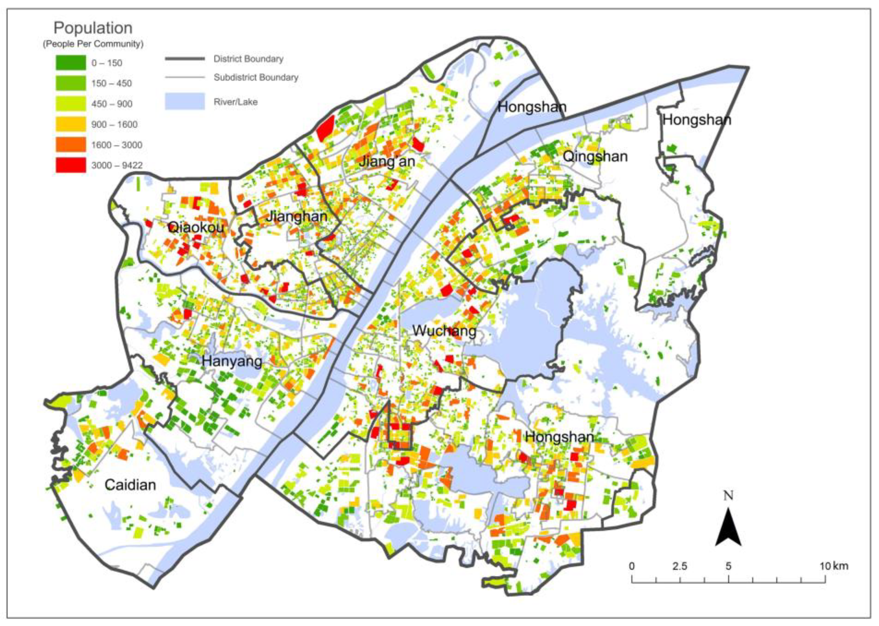
Figure 1. Population of communities (2010) and districts in the urban area of Wuhan [40].
Ijgi 10 00318 g001
Figure 2. Distribution of the pandemic-related medical facilities in the urban area of Wuhan.
Ijgi 10 00318 g002
Figure 3. Treatment procedure, supply purchase, and travel modes of COVID-19 patients and residents.
Ijgi 10 00318 g003
Figure 4. Service population of the community healthcare centers of four travel modes.
Ijgi 10 00318 g004
Figure 5. The walking time thresholds from communities to the community healthcare centers.
Ijgi 10 00318 g005
Figure 6. Service population of the fever clinics (summary unit: district) (note: a random Y-value is set for each point to avoid overlapping of points).
Ijgi 10 00318 g006
Figure 7. Service areas (in different colors) and service population (in different sizes) of the fever clinics.
Ijgi 10 00318 g007
Figure 8. Population–hospital bed ratios of the designated hospitals (summary unit: district).
Ijgi 10 00318 g008
Figure 9. Service areas (in different colors) and population–hospital bed ratios (in different size) of the designated hospitals.
Ijgi 10 00318 g009
Figure 10. Population–hospital bed ratio of the mobile cabin hospitals (summary unit: district).
Ijgi 10 00318 g010
Figure 11. Service areas (in different colors) and population–hospital bed ratios (in different sizes) of the mobile cabin hospitals.
Ijgi 10 00318 g011
Figure 12. Service population of the community pharmacies of three travel modes.
Ijgi 10 00318 g012
Figure 13. Communities in different time thresholds of the community pharmacies of walking mode.
Ijgi 10 00318 g013
Figure 14. Service population of the designated pharmacies (aggregation unit: district).
Ijgi 10 00318 g014
Figure 15. Service areas (in different colors) and service population (in different sizes) of the designated pharmacies.
Ijgi 10 00318 g015
Table 1. The potential capacity indices of various medical facilities.
Medical FacilityNumberDescriptionFormula
Community healthcare center297The population that community healthcare centers can serve under the 5, 10, and 15 min thresholds.Service population *
Fever clinic44The population that each fever clinic can serve within the service area.Service population *
Designated hospital35Combined with the hospital beds information, the service capacity of each designated hospital within the service area.Population-hospital bed ratio: Service population */The number of hospital beds
Mobile cabin hospital11Combined with the hospital beds information, the service capacity of each mobile cabin hospital within the service area.Population-hospital bed ratio: Service population */The number of hospital beds
Community pharmacy2137The population that community pharmacies can serve under the 5, 10, and 15 min thresholds.Service population *
Designated pharmacy38The population that each designated pharmacy can serve within the service area.Service population *
* Integration of communities’ population under the service area, indicating the population served by the medical facility.
Publisher’s Note: MDPI stays neutral with regard to jurisdictional claims in published maps and institutional affiliations.