
Coupling Historical Maps and LiDAR Data to Identify Man-Made Landforms in Urban Areas


Abstract
:1. Introduction
- (1)
- Quantifying the potential errors and the intrinsic accuracy of the analyzed old map;
- (2)
- Creating an old Genoa digital terrain model and quantifying urban transformations by the underlying elevation gradient with the modern digital terrain model.
2. Materials and Methods
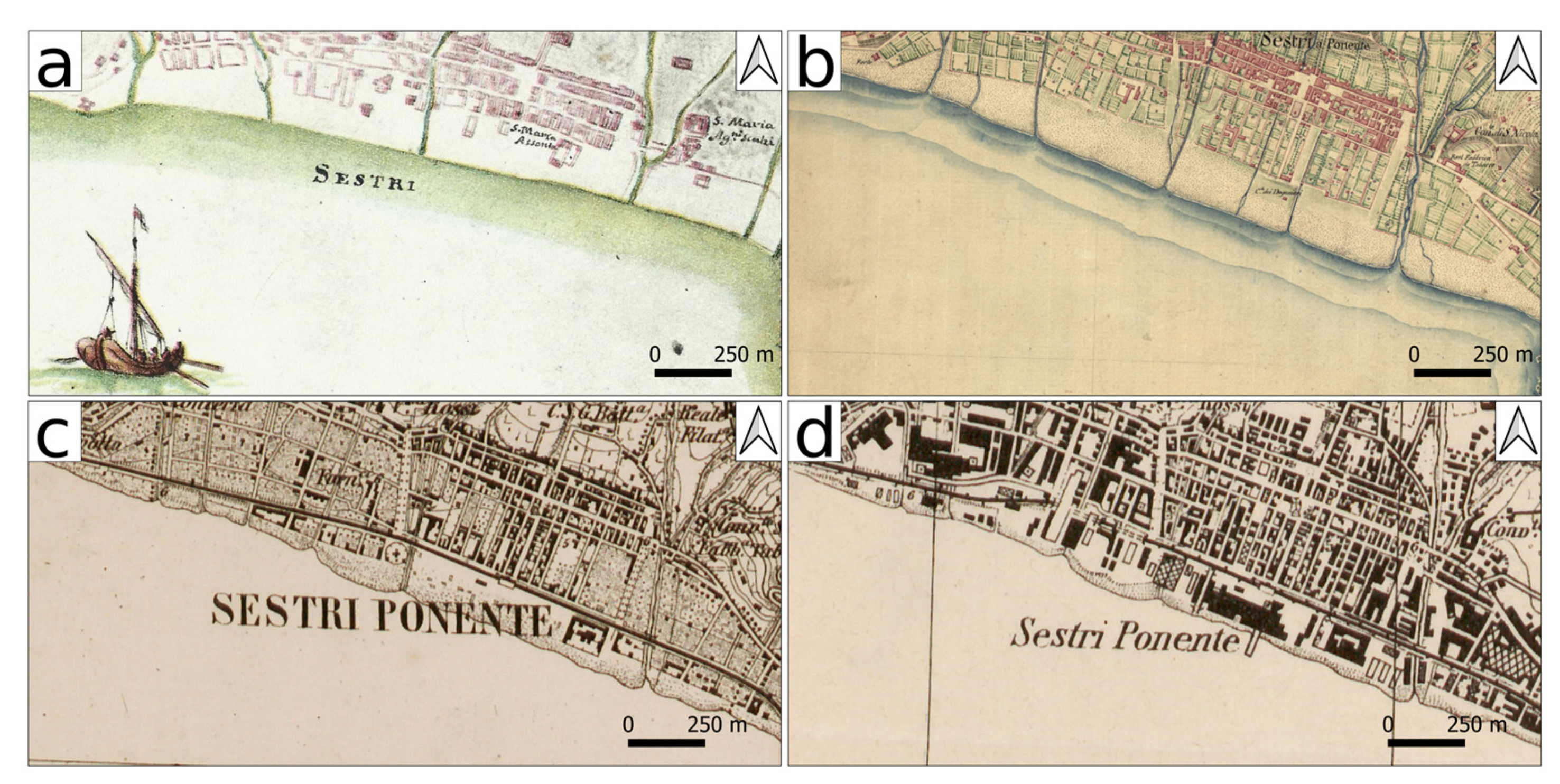
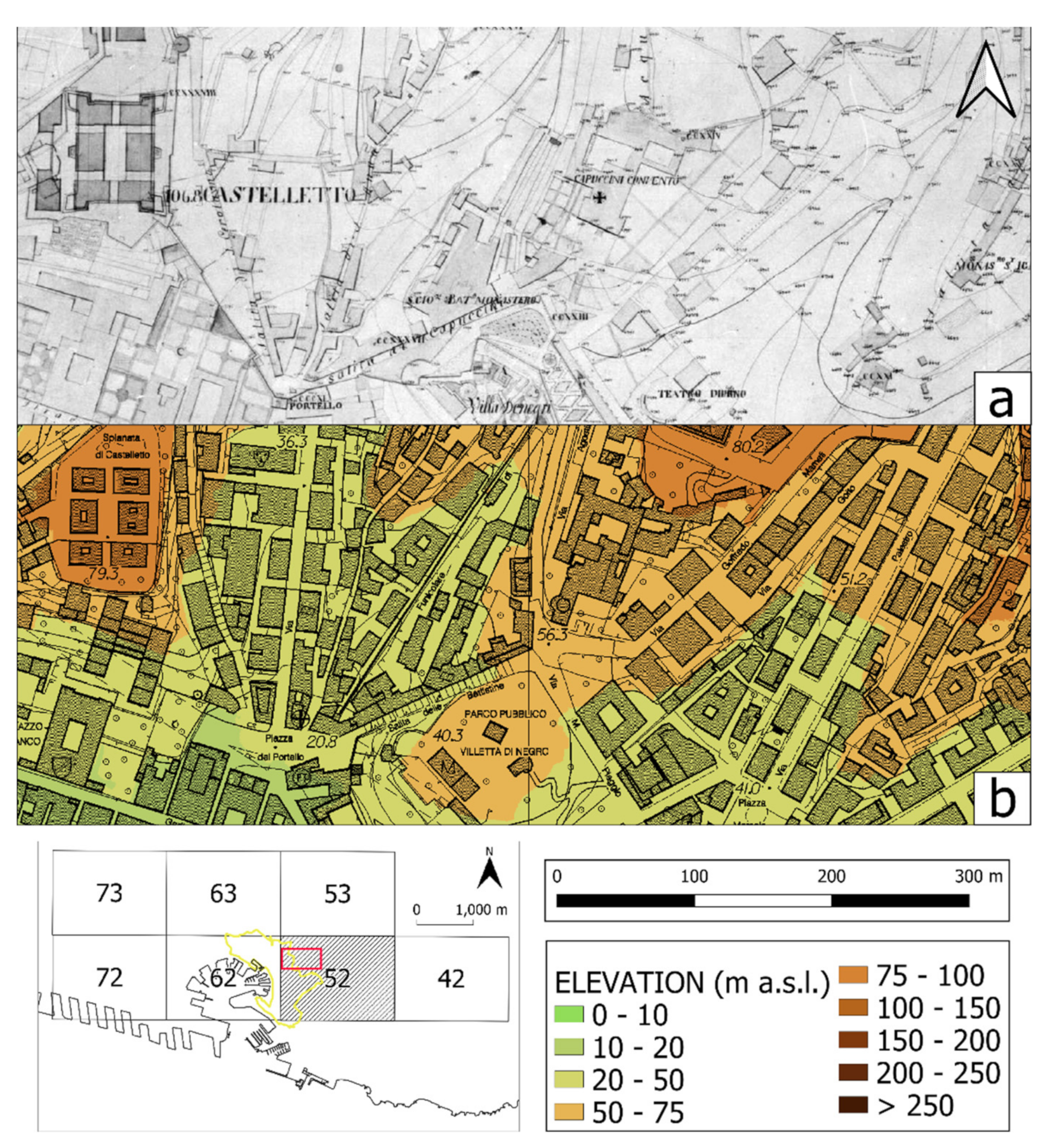
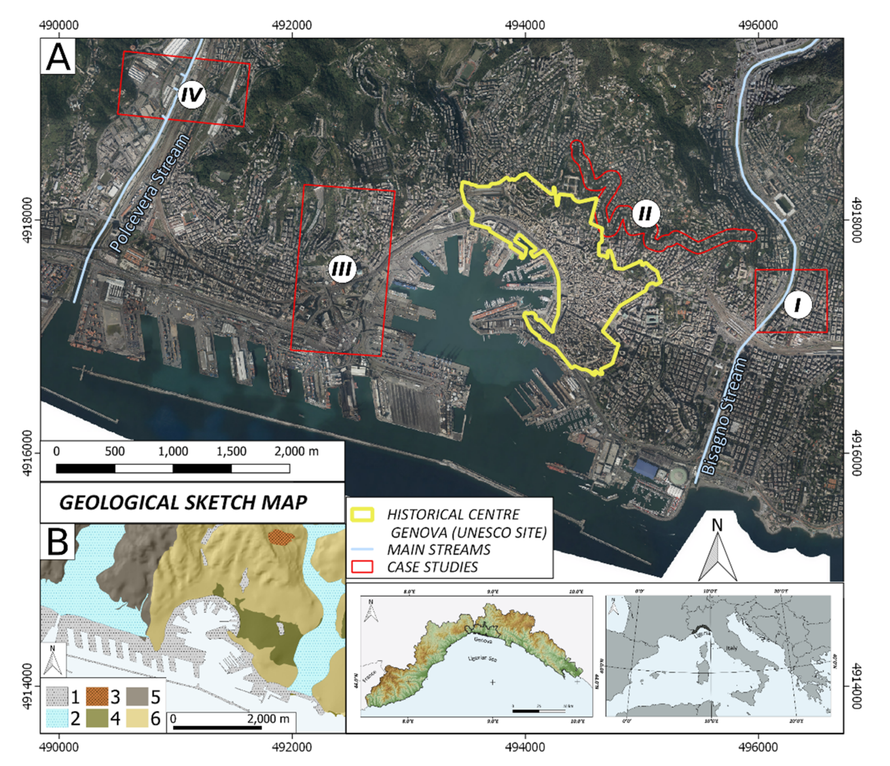
2.1. Study Area
2.2. Materials
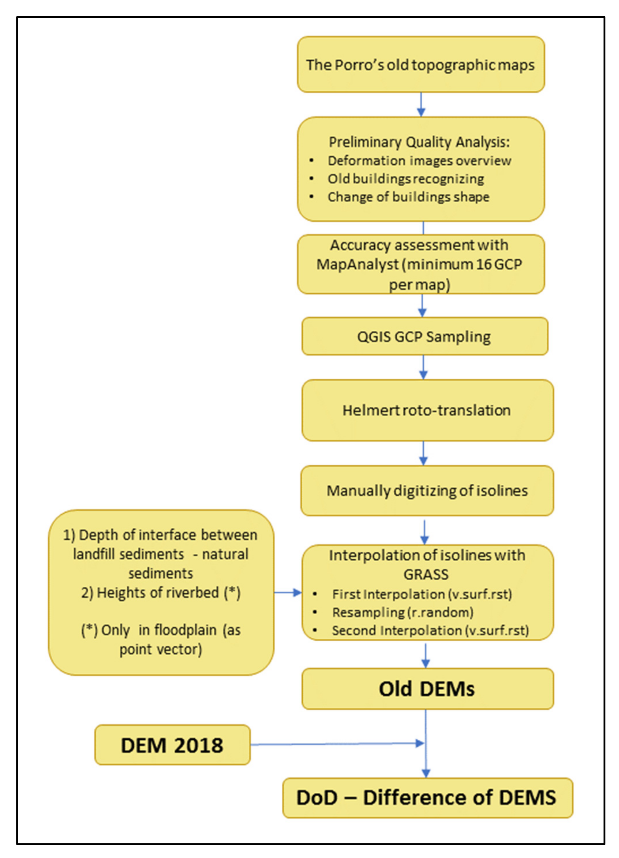
2.3. Methods
- -
- Accuracy analysis with MapAnalyst
- -
- Georeferencing and contour lines digitalization with QGIS
- -
- Interpolation and DoDs with GRASS GIS
3. Results
- (1)
- Through an analysis of potential errors, the intrinsic accuracy of 19th-century cartography was quantified;
- (2)
- Digital terrain models of early 19th-century topographical surfaces were obtained, allowing the quantification of urban transformations by underlying elevation differences.
4. Discussion
5. Conclusions
- (1)
- Areas characterized by filling landforms prevalence;
- (2)
- Areas characterized by excavation landforms prevalence;
- (3)
- Areas with no filling or excavation landforms prevalence.
Author Contributions
Funding
Conflicts of Interest
References
- Hollis, G.E. The effect of urbanization on floods of different recurrence interval. Water Res. 1975, 11, 431–435. [Google Scholar] [CrossRef]
- Brázdil, R.; Kundzewicz, Z.W.; Benito, G. Historical hydrology for studying flood risk in Europe. Hydrolog. Sci. J. 2006, 51, 739–764. [Google Scholar] [CrossRef]
- Ho, L.T.; Umitsu, M. Micro-landform classification and flood hazard assessment of the Thu Bon alluvial plain, central Vietnam via an integrated method utilizing remotely sensed data. Appl. Geogr. 2011, 31, 1082–1093. [Google Scholar] [CrossRef]
- Cunha, N.S.; Magalhães, M.R.; Domingos, T.; Abreu, M.M.; Küpfer, C. The land morphology approach to flood risk mapping: An application to Portugal. J. Environ. Manag. 2017, 193, 172–187. [Google Scholar] [CrossRef]
- Viero, D.P.; Roder, G.; Matticchio, B.; Defina, A.; Tarolli, P. Floods, landscape modifications and population dynamics in anthropogenic coastal lowlands: The Polesine (northern Italy) case study. Sci. Total Environ. 2019, 651, 1435–1450. [Google Scholar] [CrossRef]
- Canuti, P.; Casagli, N.; Pellegrini, M.; Tosatti, G. Geo-hydrological hazards. In Anatomy of an Orogen, the Apennines and Adjacent Mediterranean Basins; Vai, G.B., Martini, I.P., Eds.; Springer: Dordrecht, The Netherlands, 2019; Chapter 28; pp. 513–532. [Google Scholar]
- Paliaga, G.; Faccini, F.; Luino, F.; Turconi, L.; Bobrowsky, P. Geomorphic processes and risk related to a large landslide dam in a highly urbanized Mediterranean catchment (Genova, Italy). Geomorphology 2019, 327, 48–61. [Google Scholar] [CrossRef]
- Del Monte, M.; D’Orefice, M.; Luberti, G.M.; Marini, R.; Pica, A.; Vergari, F. Geomorphological classification of urban landscapes: The case study of Rome (Italy). J. Maps. 2016, 12, 178–189. [Google Scholar] [CrossRef] [Green Version]
- Vergari, F.; Luberti, G.M.; Pica, A.; Del Monte, M. Geomorphology of the historic centre of the Urbs (Rome, Italy). J. Maps. 2020, 1–12. [Google Scholar] [CrossRef]
- Bathrellos, G.D. An overview in urban geology and urban geomorphology. Bull. Geol. Soc. Greece 2018, 40, 1354–1364. [Google Scholar] [CrossRef] [Green Version]
- Zwoliński, Z.; Hildebrandt-Radke, I.; Mazurek, M.; Makohonienko, M. Anthropogeomorphological metamorphosis of an urban area in the postglacial landscape: A case study of Poznań city. In Urban Geomorphology: Landforms and Processes in Cities, 1st ed.; Thornbush, M., Allen, C., Eds.; Elsevier: Amsterdam, The Netherlands, 2018; pp. 55–77. [Google Scholar]
- Luino, F.; Paliaga, G.; Roccati, A.; Sacchini, A.; Turconi, L.; Faccini, F. Anthropogenic changes in the alluvial plains of the Tyrrhenian Ligurian basins. Rend. Online Soc. Geol. Ital. 2019, 48, 10–16. [Google Scholar] [CrossRef]
- Brandolini, P.; Cappadonia, C.; Luberti, G.M.; Donadio, C.; Stamatopoulos, L.; Di Maggio, C.; Del Monte, M. Geomorphology of the Anthropocene in Mediterranean urban areas. PPG Earth Environ. 2020, 44, 461–494. [Google Scholar] [CrossRef]
- Mandarino, A.; Faccini, F.; Terrone, M.; Paliaga, G. Anthropogenic landforms and geo-hydrological hazards of the Bisagno Stream catchment (Liguria, Italy). J. Maps. 2021, 118–131. [Google Scholar] [CrossRef]
- Rosenbaum, M.S.; McMillan, A.A.; Powell, J.H.; Cooper, A.H.; Culshaw, M.G.; Northmore, K.J. Classification of artificial (man-made) ground. Eng. Geol. 2003, 69, 399–409. [Google Scholar] [CrossRef] [Green Version]
- Tarolli, P.; Cao, W.; Sofia, G. From features to fingerprints: A general diagnostic framework for anthropogenic geomorphology. PPG Earth Environ. 2019, 43, 95–128. [Google Scholar] [CrossRef] [Green Version]
- Łajczak, A.; Zarychta, R.; Wałek, G. Changes in the topography of Krakow city centre, Poland, during the last millennium. J. Maps. 2010, 1–8. [Google Scholar] [CrossRef]
- El May, M.; Dlala, M.; Chenini, I. Urban geological mapping: Geotechnical data analysis for rational development planning. Eng. Geol. 2010, 116, 129–138. [Google Scholar] [CrossRef]
- Huggenberger, P.; Epting, J. Urban Geology: Process-Oriented Concept for Adaptive and Integrated Resource Management; Springer: Dordrecht, The Netherlands, 2011. [Google Scholar] [CrossRef]
- Luberti, G.M.; Vergari, F.; Marini, R.; Pica, A.; Del Monte, M. Anthropogenic modifications to the drainage network of Rome (Italy): The case study of the Aqua Mariana. Alp. Mediterr. Quat. 2018, 31, 119–132. [Google Scholar] [CrossRef]
- Luberti, G.M.; Vergari, F.; Pica, A.; Del Monte, M. Estimation of the thickness of anthropogenic deposits in historical urban centres: An interdisciplinary methodology applied to Rome (Italy). Holocene 2020, 29, 158–172. [Google Scholar] [CrossRef]
- Cajori, F. History of Determinations of the Heights of Mountains. Isis 1929, 12, 482–514. [Google Scholar] [CrossRef]
- Fuchs, R.; Verburg, P.H.; Clevers, J.G.P.W.; Herold, M. The potential of old maps and encyclopaedias for reconstructing historic European land cover/use change. Appl. Geogr. 2015, 59, 43–55. [Google Scholar] [CrossRef] [Green Version]
- Loran, C.; Haegi, S.; Ginzler, C. Comparing historical and contemporary maps-a methodological framework for a cartographic map comparison applied to Swiss maps. Int. J. Geogr. Inf. Sci. 2018, 32, 2123–2139. [Google Scholar] [CrossRef]
- Laxton, P. The Geodetic and topographical evaluation of English county maps, 1740–1840. Cartogr. J. 1976, 13, 37–54. [Google Scholar] [CrossRef]
- Rann, K.; Johnson, R.S. Chasing the line: Hutton’s contribution to the invention of contours. J. Maps 2019, 15, 48–56. [Google Scholar] [CrossRef]
- Pelletier, M. Cartography and power in France during the seventeenth and eighteenth centuries. Cartogr. Int. J. Geogr. Inf. Geovisualization 1998, 35, 41–53. [Google Scholar] [CrossRef]
- Hewitt, R. Map of a Nation: A Biography of the Ordinance Survey; Granta Publications: London, UK, 2011. [Google Scholar]
- Borgato, M.T. Great hydraulic works of French engineers during the Napoleonic Period in Italy. In Proceedings of the XXIII ICHST (International Congress of History of Science and Technology), Budapest, Hungary, 23–30 July 2009; Omigraf Ltd.: Warszawa, Poland, 2009; Volume 1, p. 143. [Google Scholar]
- Maciuk, K.; Apollo, M.; Mostowska, J.; Lepeška, T.; Poklar, M.; Noszczyk, T.; Kroh, P.; Krawczyk, A.; Borowski, L.; Pavlovčič-Prešeren, P. Altitude on Cartographic Materials and Its Correction According to New Measurement Techniques. Remote Sens. 2021, 13, 444. [Google Scholar] [CrossRef]
- Apollo, M.; Mostowska, J.; Maciuk, K.; Wengel, Y.; Jones, T.E.; Cheer, J.M. Peak-bagging and cartographic misrepresentations: A call to correction. Curr. Issues Tour. 2020, 1–6. [Google Scholar] [CrossRef]
- Cazzani, A.; Brumana, R.; Zerbi, C.M. The geo-referenced XIX century cartography: An analysis tool and a project reference for the preservation and management of built and landscape heritage. Int. Arch. Photogramm. Remote Sens. Spatial Inf. Sci 2019, XLII-2/W11, 395–402. [Google Scholar] [CrossRef] [Green Version]
- Guarducci, A.; Tarchi, G. The first geodetic map of the Grand Duchy of Tuscany georeferencing and applicated studies. e-Perimetron 2020, 15, 168–182. [Google Scholar]
- Faccini, F.; Robbiano, A.; Roccati, A.; Angelini, S. Engineering geological map of the Chiavari city area (Liguria, Italy). J. Maps 2012, 8, 41–47. [Google Scholar] [CrossRef]
- Brandolini, P.; Faccini, F.; Paliaga, G.; Piana, P. Man-made landforms survey and mapping of an urban historical center in a coastal Mediterranean environment. Geogr. Fis. Dinam. Quat. 2018, 41, 23–34. [Google Scholar]
- Laureti, L. A data archives of historical cartography. Boll. Dell’associazione Ital. Cartogr. 2010, 138, 101–108. [Google Scholar]
- Savino, S.; Rumor, M.; Congiu, S. Automated cartographic generalization in Italy. ISPRS Int. Arch. Photogramm. Remote Sens. Spatial Inf. Sci. 2011, XXXVIII-4/C21, 109–114. [Google Scholar] [CrossRef] [Green Version]
- Abbate, E.; Bortolotti, V.; Passerini, P.; Sagri, M. Introduction to the geology of the Northern Apennines. Sed. Geol. 1970, 4, 207–249. [Google Scholar] [CrossRef]
- APAT, Regione Liguria. Foglio 213230‘Genova’della Carta Geologica d’Italia alla Scala 1:50.000 [Sheet n. 213230‘Genova’of the Italian Geological Map at1:250.000 scale]. Selca Editore Firenze. 2008. Available online: http://www.isprambiente.gov.it/Media/carg/213_GENOVA/Foglio.html (accessed on 30 March 2021).
- Capponi, G.; Crispini, L.; Federico, L.; Piazza, M.; Fabbri, B. Late Alpine tectonics in the Ligurian Alps: Constraints from the Tertiary Piedmont Basin conglomerates. Geol. J. 2009, 44, 211–224. [Google Scholar] [CrossRef]
- Sacchini, A.; Imbrogio Ponaro, M.; Paliaga, G.; Piana, P.; Faccini, F.; Coratza, P. Geological Landscape and Stone Heritage of the Genoa Walls Urban Park and surrounding area (Italy). J. Maps 2018, 14, 528–541. [Google Scholar] [CrossRef]
- Faccini, F.; Giardino, M.; Paliaga, G.; Perotti, L.; Brandolini, P. Urban geomorphology of Genoa old city (Italy). J. Maps 2020, 1–14. [Google Scholar] [CrossRef]
- Brancucci, G.; Paliaga, G. Geomorphic characterization of the main drainage basins of maritime Liguria (Italy)—Preliminary results. Geogr. Fis. Din. Quat. 2005, VII, 59–67. [Google Scholar]
- Epstein, S.A. Genoa and the Genoese; University of North Carolina Press: Chapel Hill, NC, USA, 1996; pp. 958–1528. [Google Scholar]
- Paliaga, G.; Faccini, F.; Luino, F.; Roccati, A.; Turconi, L. A clustering classification of catchment anthropogenic modification and relationships with floods. Sci. Tot. Environ. 2020, 740, 139915. [Google Scholar] [CrossRef] [PubMed]
- Faccini, F.; Paliaga, G.; Piana, P.; Sacchini, A.; Watkins, C. The Bisagno stream catchment (Genoa, Italy) and its major floods: Geomorphic and land use variations in the last three centuries. Geomorphology 2016, 273, 14–27. [Google Scholar] [CrossRef]
- Paliaga, G.; Luino, F.; Turconi, L.; Marincioni, F.; Faccini, F. Exposure to Geo-hydrological hazards of the Metropolitan area of Genoa, Italy: A Multi-Temporal analysis of the Bisagno Stream. Sustainability 2020, 12, 1114. [Google Scholar] [CrossRef] [Green Version]
- Piana, P.; Faccini, F.; Luino, F.; Paliaga, G.; Sacchini, A.; Watkins, C. Geomorphological landscape research and flood management in a heavily modified Tyrrhenian catchment. Sustainability 2019, 11, 4594. [Google Scholar] [CrossRef] [Green Version]
- Rossi, L. Again on Representation of Relief. The French centrality end an early Italian case (the 19th century). Geotema 2018, 58, 70–79. [Google Scholar]
- Geoportale Regione Liguria–Sondaggi e Stratigrafie. Available online: http://srvcarto.regione.liguria.it/geoviewer2/pages/apps/geoportale/index.html?id=1030. (accessed on 30 March 2021).
- Commissario Straordinario Ricostruzione Genova–Studi Ambientali. Available online: http://www.commissario.ricostruzione.genova.it/contenuto/studi-ambientali (accessed on 30 March 2021).
- Williams, R. DEMs of difference. In Geomorphological Techniques; BSG: London, UK, 2012; Volume 2. [Google Scholar]
- McMillan, A.A.; Powell, J.H. Classification of artificial (man-made) ground and natural superficial deposits applications to geological maps and datasets in the UK. BGS Rock Classifi. Scheme 1999, 4, RR99–04. [Google Scholar]
- Fiz, I.; Orengo, H.A. Simulating Communication Routes in Mediterranean Alluvial Plains. In Proceedings of the Layers of Perception: The 35th International Conference on Computer Applications and Quantitative Methods in Archaeology (CAA), Berlin, Germany, 2–6 April 2007; Posluschny, A., Lambers, K., Herzog, I., Eds.; Rudolf Habelt: Bonn, Germany, 2008; pp. 309–315. [Google Scholar]
- Molewski, P.; Juśkiewicz, W. An attempt to reconstruct the primary relief of the Old Town of Toruń and its close suburbs on the basis of the geological and historical geoinformation. Landf. Anal. 2014, 25, 115–124. [Google Scholar] [CrossRef]
- Cheung, C.K.; Shi, W. Estimation of the positional uncertainty in line simplification in GIS. Cart. J. 2004, 41, 37–45. [Google Scholar] [CrossRef]
- Zitová, B.; Flusser, J. Image registration methods: A survey. Image Vision. Comput. 2003, 21, 977–1000. [Google Scholar] [CrossRef] [Green Version]
- Fara, A. La Carta di Ignazio Porro: Cartografia per L’architettura Militare Nella Genova Della Prima Metà Dell’ottocento [Ignazio Porro’s Map: Cartography for Military Architecture in Genoa in the First Half of the Nineteenth Century]; Stato maggiore dell’esercito-Ufficio storico: Rome, Italy, 1986. [Google Scholar]
- Leopold, L.B.; Wolman, M.G. River Channel Patterns: Braided, Meandering, and Straight; Professional Paper 282-B; U.S. Government Printing Office: Washington, DC, USA, 1957.
- Zwolinski, Z. Sedimentology and geomorphology of overbank flows on meandering river floodplains. Geomorphology 1992, 4, 367–379. [Google Scholar] [CrossRef]
- Fassosi-Andrade, A.C.; Cauduro Dias de Paiva, R.; Fleischmann, A.S. Lake Topography and Active Storage from Satellite Observations of Flood Frequency. Water Resour. Res. 2020, 56. [Google Scholar] [CrossRef]
- Stoker, J.; Harding, D.; Parrish, J. The need for a national LiDAR dataset Photogrammetric. Eng. Remote Sens. 2008, 74, 1066–1068. [Google Scholar]
- Mitàsova, H.; Mitàs, L. Interpolation by Regularized Spline with Tension: I. Theory and Implementation. Math. Geol. 1993, 25, 641–655. [Google Scholar] [CrossRef]
- De Floriani, L.; Puppo, E. Multiresolution Models for Terrain Surface Description. Vis. Comput. 1996, 12, 317–345. [Google Scholar] [CrossRef]
- James, L.A.; Hodgson, M.E.; Ghoshal, S.; Latiolais, M.M. Geomorphic change detection using historic maps and DEM differencing: The temporal dimension of geospatial analysis. Geomorphology 2012, 137, 181–198. [Google Scholar] [CrossRef]
- Moatti, J.P.; Thiébault, S. The Mediterranean Region under Climate Change; IRD Éditions: Marseilles, France, 2016. [Google Scholar] [CrossRef]
- Piana, P.; Watkins, C. Questioning the view: Historical geography and topographical art. Geogr. Compass 2020, 14, e12483. [Google Scholar] [CrossRef]
- Faccini, F.; Luino, F.; Sacchini, A.; Turconi, L. Flash flood events and urban development in Genoa (Italy): Lost in translation. In Engineering Geology for Society and Territory; Lollino, G., Manconi, A., Guzzetti, F., Culshaw, M., Bobrowsky, P., Luino, F., Eds.; Springer International Publishing: Cham, Switzerland, 2015; Volume 5, pp. 797–801. [Google Scholar] [CrossRef]
- Brandolini, P.; Cevasco, A.; Firpo, M.; Robbiano, A.; Sacchini, A. Geo-hydrological risk management for civil protection purposes in the urban area of Genoa (Liguria, NW Italy). Nat. Haz. Earth Sys. 2012, 12, 943–959. [Google Scholar] [CrossRef] [Green Version]
- Lanza, S.G. Flood hazard threat on cultural heritage in the town of Genoa (Italy). J. Cult. Herit. 2003, 4, 159–167. [Google Scholar] [CrossRef]
- Bandecchi, A.E.; Pazzi, V.; Morelli, S.; Valori, L.; Casagli, N. Geo-hydrological and seismic risk awareness at school: Emergency preparedness and risk perception evaluation. Int. J. Disaster Risk Reduct. 2019, 40, 101280. [Google Scholar] [CrossRef]
- Faccini, F.; Robbiano, A.; Sacchini, A. Geomorphic hazards and intense rainfall: The case study of the Recco Stream catchment (Eastern Liguria, Italy). Nat. Haz. Earth Syst. Sci. 2012, 12, 893–903. [Google Scholar] [CrossRef] [Green Version]


| Plate Number | STD DEV (Helmert) | RMSE (Helmert) | STD DEV (Affine 5) | RMSE (Affine 5) | STD DEV (Affine 6) | RMSE (Affine 6) | N° GCP |
|---|---|---|---|---|---|---|---|
| 42 | 3.062 | 4.331 | 3.227 | 4.564 | 2.753 | 3.894 | 16 |
| 52 | 2.620 | 3.705 | 2.529 | 3.577 | 2.399 | 3.393 | 22 |
| 53 | 3.867 | 5.469 | 3.266 | 4.618 | 3.267 | 4.620 | 17 |
| 62 | 2.683 | 3.795 | 2.617 | 3.702 | 2.573 | 3.639 | 20 |
| 63 | 2.783 | 3.937 | 2.649 | 3.746 | 2.686 | 3.799 | 17 |
| 72 | 2.892 | 4.090 | 3.084 | 4.362 | 3.305 | 4.674 | 16 |
| 73 | 4.922 | 6.961 | 5.136 | 7.263 | 4.986 | 7.051 | 16 |
Publisher’s Note: MDPI stays neutral with regard to jurisdictional claims in published maps and institutional affiliations. |
© 2021 by the authors. Licensee MDPI, Basel, Switzerland. This article is an open access article distributed under the terms and conditions of the Creative Commons Attribution (CC BY) license (https://creativecommons.org/licenses/by/4.0/).
Share and Cite
Terrone, M.; Piana, P.; Paliaga, G.; D’Orazi, M.; Faccini, F. Coupling Historical Maps and LiDAR Data to Identify Man-Made Landforms in Urban Areas. ISPRS Int. J. Geo-Inf. 2021, 10, 349. https://doi.org/10.3390/ijgi10050349
Terrone M, Piana P, Paliaga G, D’Orazi M, Faccini F. Coupling Historical Maps and LiDAR Data to Identify Man-Made Landforms in Urban Areas. ISPRS International Journal of Geo-Information. 2021; 10(5):349. https://doi.org/10.3390/ijgi10050349
Chicago/Turabian StyleTerrone, Martino, Pietro Piana, Guido Paliaga, Marco D’Orazi, and Francesco Faccini. 2021. "Coupling Historical Maps and LiDAR Data to Identify Man-Made Landforms in Urban Areas" ISPRS International Journal of Geo-Information 10, no. 5: 349. https://doi.org/10.3390/ijgi10050349
APA StyleTerrone, M., Piana, P., Paliaga, G., D’Orazi, M., & Faccini, F. (2021). Coupling Historical Maps and LiDAR Data to Identify Man-Made Landforms in Urban Areas. ISPRS International Journal of Geo-Information, 10(5), 349. https://doi.org/10.3390/ijgi10050349