Integration and Analysis of Multi-Modal Geospatial Secondary Data to Inform Management of at-Risk Archaeological Sites
Abstract
:1. Introduction
2. Materials and Methods
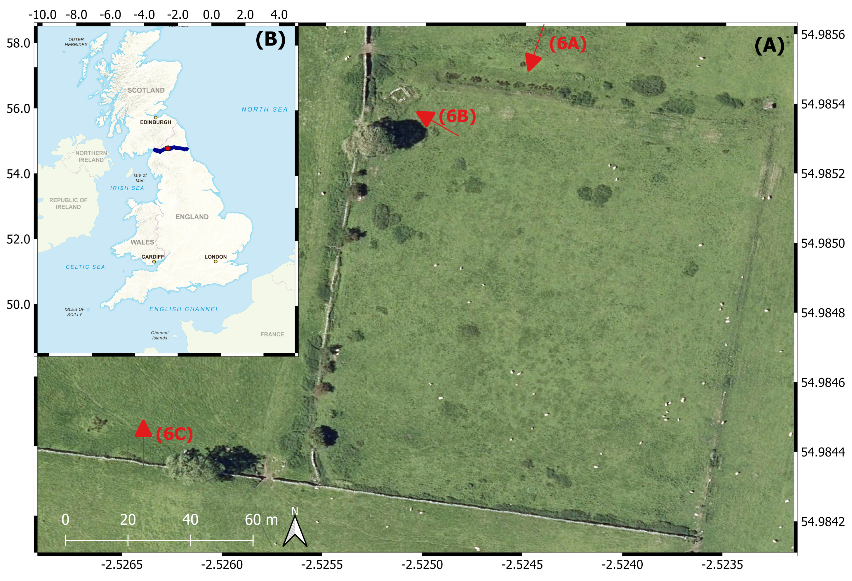
2.1. Research Area
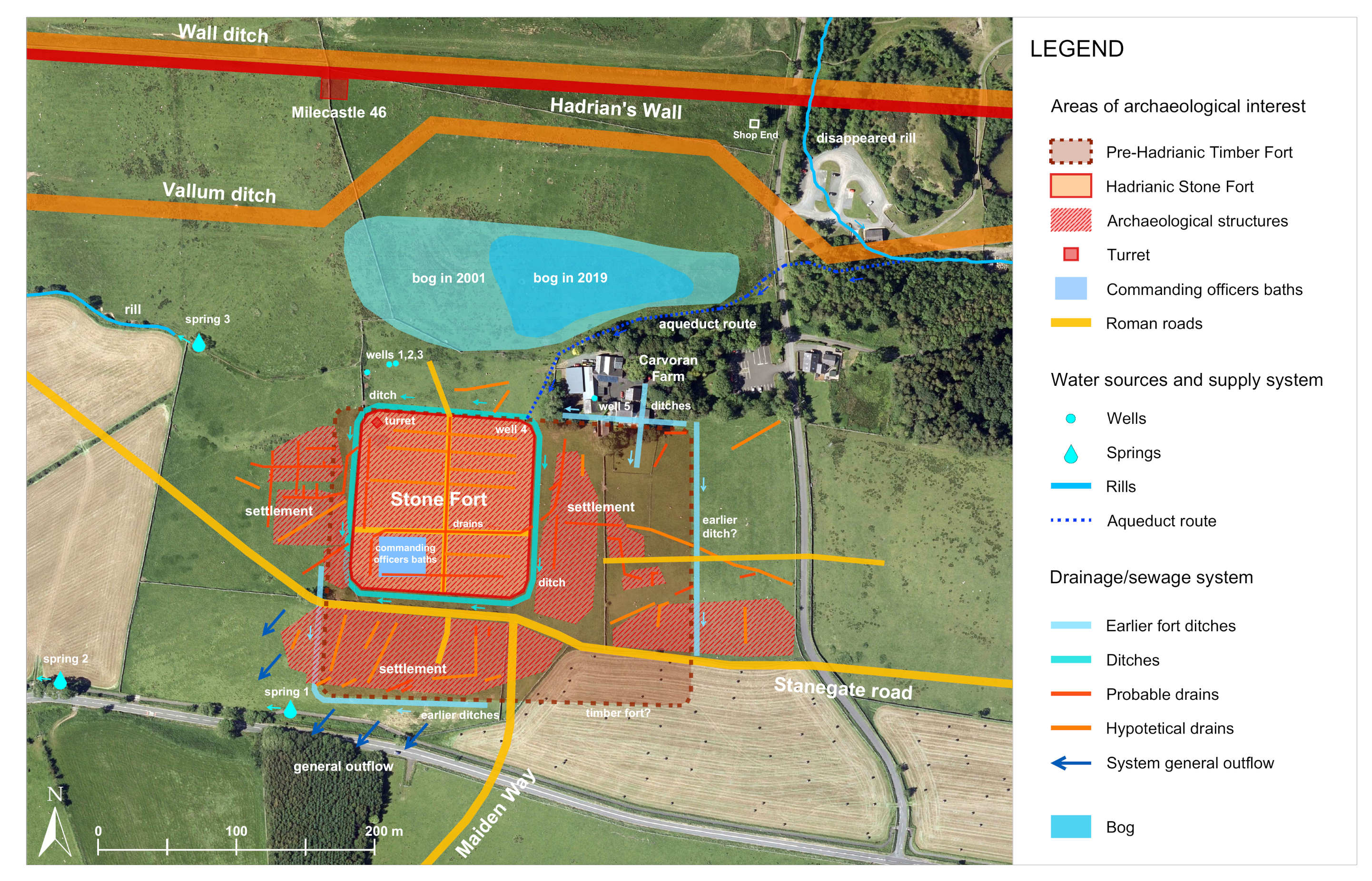
2.2. Ancient Hydraulic System
2.3. Digital Elevation Extracted Site Parameters
2.4. Spatio-Temporal Analysis of NDVI
2.5. Modelling Soil Erosion
2.6. Estimation of Future Erosion Risk
2.7. Web Dashboard
3. Results
3.1. Water System Dynamics
3.2. Ancient Hydraulic System
3.3. Trends in Vegetation Cover
3.4. Spatial Variation in Soil Erosion Risk
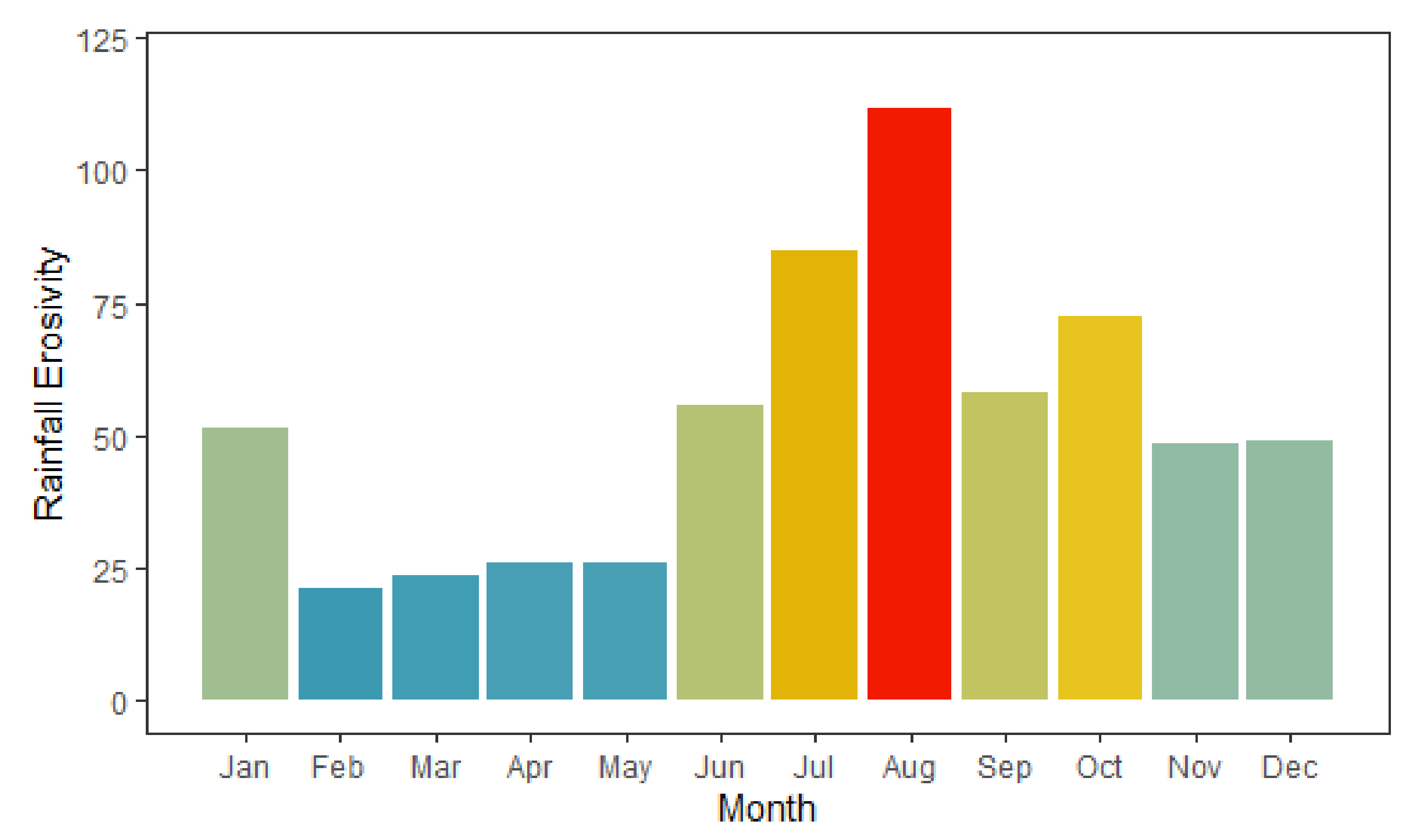
3.5. Inter-Annual Variability in Erosion Risk
Projected Future Changes in Erosion Risk
4. Discussion
4.1. The Aquifer and Hydraulic System
- The Roman sewage system, usually located underneath the mains roads, collecting wastewater from the buildings of the fort and settlement (from the anomaly plan of the Timescape geophysical survey of 1999 we can observe the position of possible roads and related drains).
- The Roman drainage system, consisting of open-air channels with a drainage function, located along the perimeter of the fort and in the site’s ground lowest levels to remove waters from the area.
- The numerous modern farming drains built from the 1820s for agricultural purposes, that constitute the actual drainage system of the site.
4.2. Lack of Visible Long-Term Degradation
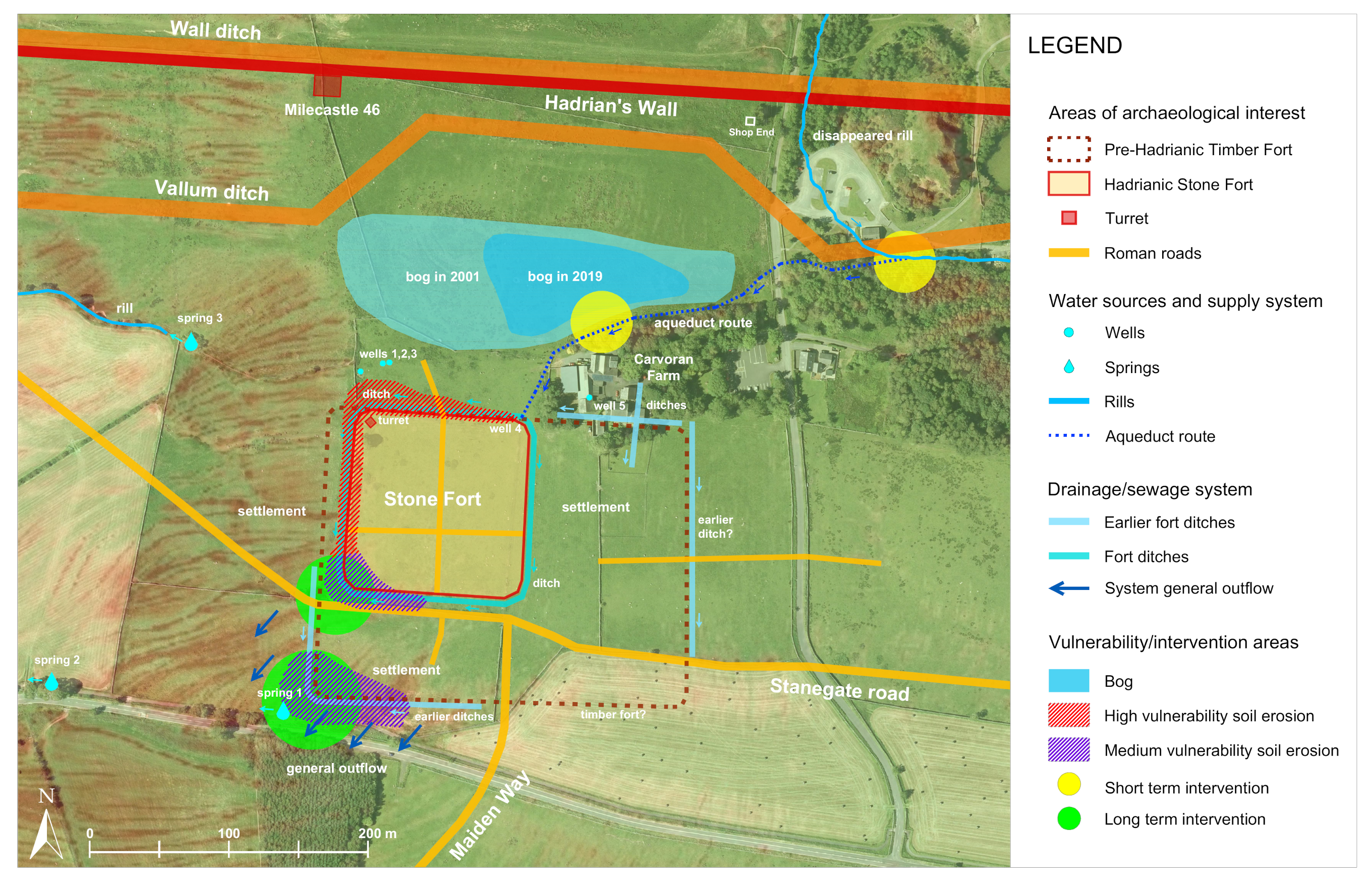
4.3. Potential Future Degradation
5. Conclusions
5.1. Short-Term Recommendations:
- Carry out geological surveys to the north east of Carvoran Farm (distance 240 m) to investigate the presence of the water source suggested in the literature.
- Plan priority excavations of the ancient drainage/sewage system channels and ditches aimed for water management along with the modern agricultural field drains to be purposefully blocked or opened up depending on the requirements to either re-saturate or remove water from different parts of the site.
- Facilitate additional risk analysis layers for actions of tourists at the site, particularly in the summer months when erosion risk is highest, and around erosion hot spots identified in Figure 9.
5.2. Long-Term Recommendations:
- Investigate the ancient hydraulic system general outflow at the south-west corner of the Stone Fort and at the south-west corner of the potential earlier Timber Fort. Monitoring of continued water drainage in this area should occur, to guard against future erosion.
- Locate, excavate and, if possible, restore the Roman aqueduct’s channel along the route proposed by the hydraulic system map. A new water inlet will help enlarge the area of the bog and maintain soil moisture levels for the entire site, sustaining the conditions in which organic materials and wooden artefacts can be preserved.
- Investigate the presence and consistency of the local aquifer.
- Plan geognostic surveys to analyse the soil stratigraphy and to evaluate its geological and geotechnical characteristics and chemical analysis of the soil.
- Plan new and detailed geophysics surveys.
- Undertake a detailed geoarchaeological assessment of the sites various preservation conditions through a selected sampling system with limited bore holes to establish the state of the remains across the site.
- Provide a monitoring system of the oscillation of groundwater levels in the well of Carvoran Farm to understand the impact of the water table oscillation on the humidity of the surface soil.
- Plan photogrammetric monitoring surveys, regularly scheduled if research excavations progress.
Supplementary Materials
Author Contributions
Funding
Institutional Review Board Statement
Informed Consent Statement
Data Availability Statement
Acknowledgments
Conflicts of Interest
References
- UNESCO. UNESCO World Heritage List, Frontiers of the Roman Empire. Available online: https://whc.unesco.org/en/list/430/ (accessed on 25 March 2021).
- Vindolanda Charitable Trust. Available online: https://www.vindolanda.com/ (accessed on 28 June 2021).
- Henderson, T. The Secret Hadrian’s Wall Fort That Could Be Lost Forever. Available online: https://www.chroniclelive.co.uk/news/north-east-news/magna-fort-hadrians-wall-vindolanda-17570462 (accessed on 25 March 2021).
- Historic England. Facing the Future: Foresight and the Historic Environment. Available online: https://historicengland.org.uk/images-books/publications/facing-the-future/ (accessed on 26 March 2021).
- South West Heritage Trust. Archaeological Sites at Risk from Climate Change. Available online: https://swheritage.org.uk/news/archaeological-sites-at-risk-from-climate-change/ (accessed on 25 March 2021).
- Campana, S.; Remondino, F.; Ioannides, M. GIS in Cultural Heritage; The International Journal of Heritage in the Digital Era; Sage: Los Angeles, CA, USA, 2013. [Google Scholar]
- Themistocleous, K.; Agapiou, A.; Cuca, B.; Hadjimitsis, D. Unmanned Aerial Systems and Spectroscopy for Remote Sensing Applications in Archaeology. ISPRS Int. Arch. Photogramm. Remote Sens. Spat. Inf. Sci. 2015, XL-7/W3, 1419–1423. [Google Scholar] [CrossRef] [Green Version]
- Fieber, K.; Mills, J.; Peppa, M.V.; Haynes, I.; Turner, S.; Turner, A.; Douglas, M.; Bryan, P. Cultural Heritage through Time: A Case Study at Hadrian’S Wall, United Kingdom. ISPRS Int. Arch. Photogramm. Remote Sens. Spat. Inf. Sci. 2017, XL-2/W3, 297–302. [Google Scholar] [CrossRef] [Green Version]
- Rayne, L.; Bradbury, J.; Mattingly, D.; Philip, G.; Bewley, R.; Wilson, A. From Above and on the Ground: Geospatial Methods for Recording Endangered Archaeology in the Middle East and North Africa. Geosciences 2017, 7, 100. [Google Scholar] [CrossRef] [Green Version]
- Traviglia, A.; Cottica, D. Remote sensing applications and archaeological research in the Northern Lagoon of Venice: The case of the lost settlement of Constanciacus. J. Archaeol. Sci. 2011, 38, 2040–2050. [Google Scholar] [CrossRef]
- Basnet, K.; Paudel, R.C.; Sherchan, B. Analysis of watersheds in Gandaki Province, Nepal using QGIS. Tech. J. 2019, 1, 16–28. [Google Scholar] [CrossRef]
- Marques da Silva, J.R.; Silva, L.L. Relationship between distance to flow accumulation lines and spatial variability of irrigated maize grain yield and moisture content at harvest. Biosyst. Eng. 2006, 94, 525–533. [Google Scholar] [CrossRef] [Green Version]
- Florinsky, I.V. Relationships between topographically expressed zones of flow accumulation and sites of fault intersection: Analysis by means of digital terrain modelling. Environ. Model. Softw. 2000, 15, 87–100. [Google Scholar] [CrossRef]
- Qin, C.Z.; Zhan, L. Parallelizing flow-accumulation calculations on graphics processing units—From iterative DEM preprocessing algorithm to recursive multiple-flow-direction algorithm. Comput. Geosci. 2012, 43, 7–16. [Google Scholar] [CrossRef]
- Hodge, A.T. Roman Aqueducts & Water Supply; Duckworth: London, UK, 1992. [Google Scholar]
- Birley, R. The Fort at the Rock: On Hadrian’s Wall: Magna and Carvoran; Roman Army Museum Publications for the Vindolanda Trust; Roman Army Museum, Greenhead: Brampton, ON, Canada, 1998; pp. 21–23. [Google Scholar]
- Howland, M.; Jones, I.; Najjar, M.; Levy, T. Quantifying the effects of erosion on archaeological sites with low-altitude aerial photography, structure from motion, and GIS: A case study from southern Jordan. J. Archaeol. Sci. 2018, 90, 62–70. [Google Scholar] [CrossRef] [Green Version]
- Wischmeier, W.; Smith, D. Predicting Rainfall Erosion Losses—A Guide To Conservation Planning. Agric. Handb. 1978, 537, 62. [Google Scholar]
- Renard, K.; Foster, G.; Weesies, G.; Mccool, D.; Yoder, D. Predicting soil erosion by water: A guide to conservation planning with the revised universal soil loss equation (RUSLE). Agric. Handb. 1997, 703, 1–251. [Google Scholar]
- Marondedze, A.; Schütt, B. Assessment of Soil Erosion Using the RUSLE Model for the Epworth District of the Harare Metropolitan Province, Zimbabwe. Sustainability 2020, 12, 8531. [Google Scholar] [CrossRef]
- Panagos, P.; Borrelli, P.; Poesen, J.; Ballabio, C.; Meusburger, K.; Montanarella, L.; Lugato, E.; Alewell, C. The new assessment of soil loss by water erosion in Europe. Environ. Sci. Policy 2015, 54, 438–447. [Google Scholar] [CrossRef]
- Thapa, P. Spatial Estimation of Soil Erosion Using RUSLE Modeling: A case study of Dolakha District, Nepal. Environ. Syst. Res. 2020, 9, 1–10. [Google Scholar] [CrossRef]
- Ghosal, K.; Das, S. A Review of RUSLE Model. J. Indian Soc. Remote Sens. 2020, 48, 689–707. [Google Scholar] [CrossRef]
- Wang, G.; Gertner, G.; Singh, V.; Shinkareva, S.; Parysow, P.; Anderson, A. Spatial and temporal prediction and uncertainty of soil loss using the revised universal soil loss equation: A case study of the rainfall-runoff erosivity R factor. Ecol. Model. 2002, 153, 143–155. [Google Scholar] [CrossRef]
- Panagos, P.; Ballabio, C.; Meusburger, K.; Spinoni, J.; Alewell, C.; Borrelli, P. Towards estimates of future rainfall erosivity in Europe based on REDES and WorldClim datasets. J. Hydrol. 2017, 548, 251–262. [Google Scholar] [CrossRef]
- Vantas, K.; Sidiropoulos, E.; Loukas, A. Estimating Current and Future Rainfall Erosivity in Greece Using Regional Climate Models and Spatial Quantile Regression Forests. Water 2020, 12, 687. [Google Scholar] [CrossRef] [Green Version]
- Sardari, M.; Bazrafshan, O.; Panagopoulos, T.; Rafiei Sardooi, E. Modeling the Impact of Climate Change and Land Use Change Scenarios on Soil Erosion at the Minab Dam Watershed. Sustainability 2019, 11, 3353. [Google Scholar] [CrossRef] [Green Version]
- Almagro, A.; Oliveira, P.T.; Nearing, M.; Hagemann, S. Projected climate change impacts in rainfall erosivity over Brazil. Sci. Rep. 2017, 7, 1–12. [Google Scholar] [CrossRef] [Green Version]
- Historic England Research Records. Available online: https://www.heritagegateway.org.uk/Gateway/Results_Single.aspx?uid=13857&resourceID=19191# (accessed on 5 April 2021).
- Roman Vindolanda. Available online: https://hadrianswallcountry.co.uk/visit/roman-vindolanda (accessed on 28 June 2021).
- Vindolanda Charitable Trust. Wonderful Water Pipes. Available online: https://www.vindolanda.com/blogs/blog/wonderful-water-pipes (accessed on 5 April 2021).
- Vindolanda Fort and Vicus Excavation Areas 2015. Available online: https://sketchfab.com/3d-models/vindolanda-fort-and-vicus-excavation-areas-2015-4ef8168053794fc8817a0a90933830c6 (accessed on 5 April 2021).
- Environment Agency. Lidar Data. 2019. Available online: https://environment.data.gov.uk/DefraDataDownload/?Mode=survey (accessed on 3 March 2021).
- Caplan, J.; Ruesink, M.; Mitasova, H. GRASS GIS Manual: R.Flow. 2015. Available online: http://wgbis.ces.iisc.ernet.in/grass/grass73/manuals/r.flow.html (accessed on 5 April 2021).
- López-Vicente, M.; Pérez-Bielsa, C.; López-Montero, T.; Lambán, L.; Navas, A. Runoff simulation with eight different flow accumulation algorithms: Recommendations using a spatially distributed and open-source model. Environ. Model. Softw. 2014, 62, 11–21. [Google Scholar] [CrossRef] [Green Version]
- Arnold, N. A new approach for dealing with depressions in digital elevation models when calculating flow accumulation values. Prog. Phys. Geogr. Earth Environ. 2010, 34, 781–809. [Google Scholar] [CrossRef]
- Gleyzer, A.; Denisyuk, M.; Rimmer, A.; Salingar, Y. A Fast Recursive Gis Algorithm for Computing Strahler Stream Order in Braided and Nonbraided Networks. J. Am. Water Resour. Assoc. 2004, 40, 937–946. [Google Scholar] [CrossRef]
- Collins, B.D.; Corbett, S.C.; Fairley, H.C.; Minasian, D.; Kayen, R.; Dealy, T.P.; Bedford, D.R. Topographic change detection at select archeological sites in Grand Canyon National Park, Arizona, 2007–2010. US Geol. Surv. Sci. Investig. Rep. 2012, 5133, 77. [Google Scholar]
- Carlson, T.N.; Perry, E.M.; Schmugge, T.J. Remote estimation of soil moisture availability and fractional vegetation cover for agricultural fields. Agric. Forest Meteorol. 1990, 52, 45–69. [Google Scholar] [CrossRef]
- Garland, N. Hadrians Wall—Frontier System. Available online: https://data.ncl.ac.uk/articles/dataset/Hadrian_s_Wall_-_Frontier_system/11855592 (accessed on 3 March 2021).
- Tan, K.C.; Lim, H.S.; Matjafri, M.Z.; Abdullah, K. Landsat data to evaluate urban expansion and determine land use/land cover changes in Penang Island, Malaysia. Environ. Earth Sci. 2009, 60, 1509–1521. [Google Scholar] [CrossRef]
- Ganasri, B.; Gowda, R. Assessment of soil erosion by RUSLE model using remote sensing and GIS—A case study of Nethravathi Basin. Geosci. Front. 2015, 7. [Google Scholar] [CrossRef] [Green Version]
- Panagos, P.; Meusburger, K.; Ballabio, C.; Borrelli, P.; Alewell, C. Soil erodibility in Europe: A high-resolution dataset based on LUCAS. Sci. Total Environ. 2014, 479–480, 189–200. [Google Scholar] [CrossRef]
- Panagos, P.; Borrelli, P.; Meusburger, K.; Zanden, E.; Poesen, J.; Alewell, C. Modelling the effect of support practices (P-factor) on the reduction of soil erosion by water at European Scale. Environ. Sci. Policy 2015, 51, 23–34. [Google Scholar] [CrossRef]
- Panagos, P.; Borrelli, P.; Meusburger, K.; Alewell, C.; Lugato, E.; Montanarella, L. Estimating the soil erosion cover-management factor at the European scale. Land Use Policy 2015, 48, 38–50. [Google Scholar] [CrossRef]
- ESDAC. European Soil Data Centre. Available online: esdac.jrc.ec.europa.eu (accessed on 10 March 2021).
- Desmet, P.; Govers, G. A GIS procedure for automatically calculating the USLE LS factor on topographically complex landscape units. J. Soil Water Conserv. 1996, 51, 427–433. [Google Scholar]
- Yang, X.; Yu, B. Modelling and mapping rainfall erosivity in New South Wales, Australia. Soil Res. 2015, 53, 178–189. [Google Scholar] [CrossRef]
- Brown, L.; Foster, G. Storm Erosivity Using Idealized Intensity Distributions. Trans. ASAE 1987, 30, 379–386. [Google Scholar] [CrossRef]
- Panagos, P.; Ballabio, C.; Borrelli, P.; Meusburger, K.; Klik, A.; Rousseva, S.; Percec Tadic, M.; Michaelides, S.; Hrabalikova, M.; Olsen, P.; et al. Rainfall erosivity in Europe. Sci. Total Environ. 2015, 511, 801–814. [Google Scholar] [CrossRef] [Green Version]
- Voldoire, A. CNRM-CERFACS CNRM-CM6-1 Model Output Prepared for CMIP6 HighResMIP. Earth Syst. Grid Fed. 2019. [Google Scholar] [CrossRef]
- Fick, S.; Hijmans, R. WorldClim 2: New 1-km spatial resolution climate surfaces for global land areas. Int. J. Climatol. 2017, 37, 4302–4315. [Google Scholar] [CrossRef]
- The Fort at the Rock. Available online: https://thefortattherock.com/ (accessed on 28 June 2021).
- Ballabio, C.; Borrelli, P.; Spinoni, J.; Meusburger, K.; Michaelides, S.; Beguería, S.; Klik, A.; Petan, S.; Janecek, M.; Olsen, P.; et al. Mapping monthly rainfall erosivity in Europe. Sci. Total Environ. 2016, 579, 1298–1315. [Google Scholar] [CrossRef] [PubMed] [Green Version]
- Bowman, A.K.; Thomas, J.D.; Tomlin, R.S. The Vindolanda Writing-Tablets (Tabulae Vindolandenses IV, Part 2). Britannia 2011, 42, 113–144. [Google Scholar] [CrossRef]
- Birley, R. Vindolanda: A Roman Frontier Post on Hadrian’s Wall; Thames and Hudson: London, UK, 1977. [Google Scholar]
- Code of Respect. Available online: https://hadrianswallcountry.co.uk/walking/code-respect (accessed on 5 April 2021).
- Lasaponara, R.; Masini, N. Identification of archaeological buried remains based on the normalized difference vegetation index (NDVI) from Quickbird satellite data. IEEE Geosci. Remote Sens. Lett. 2006, 3, 325–328. [Google Scholar] [CrossRef]
- Bilotta, G.; Brazier, R.; Haygarth, P. The Impacts of Grazing Animals on the Quality of Soils, Vegetation, and Surface Waters in Intensively Managed Grasslands. Adv. Agron. 2007, 94, 237–280. [Google Scholar] [CrossRef]
- Winchell, M.; Jackson, S.; Wadley, A.; Srinivasan, R. Extension and Validation of a Geographic Information System-Based Method for Calculating the Revised Universal Soil Loss Equation Length-Slope Factor for Erosion Risk Assessments in Large Watersheds. J. Soil Water Conserv. 2008, 63, 105–111. [Google Scholar] [CrossRef]
- Scheper, S.; Simon, T.; Meusburger, K. Modification of the Rusle Slope Length and Steepness Factor (Ls-Factor) Based on Rainfall Experiments at Steep Alpine Grasslands. MethodsX 2019, 6, 219–229. [Google Scholar]
- ArcGIS. ArcGIS Pro: An Overview of the Hydrology Toolset. 2021. Available online: https://pro.arcgiscom/en/pro-app/latest/tool-reference/spatial-analyst/an-overview-of-the-hydrology-tools.htm (accessed on 3 March 2021).
- Panagos, P.; Borrelli, P.; Meusburger, K. A New European Slope Length and Steepness Factor (LS-Factor) for Modeling Soil Erosion by Water. Geosciences 2015, 2015, 117–126. [Google Scholar] [CrossRef] [Green Version]
- Wischmeier, W.H.; Smith, D.D. Predicting rainfall erosion losses in the Eastern US—A guide to conservation planning. Agric. Handb. 1965, 282. [Google Scholar]
- Mccool, D.; Foster, G.; Yoder, D.; Weesies, G.A.; McGregor, K.C. The Revised Universal Soil Loss Equation, Version 2. In International Soil Conservation Organization Conference Proceedings; ISCO: Brisbane, Australia, 2004. [Google Scholar]
- Oliveira, P.T.; Wendland, E.; Nearing, M. Rainfall Erosivity in Brazil: A Review. CATENA 2013, 100, 139–147. [Google Scholar] [CrossRef]
- Met Office. MIDAS Open: UK Hourly Rainfall Data, v202007; Centre for Environmental Data Analysis: London, UK, 21 October 2020. [Google Scholar]
- Vantas, K. hyetor: R Package to Analyze Fixed Interval Precipitation Time Series [Online]. 2018. Available online: https://kvantas.github.io/hyetor/ (accessed on 14 March 2021).


| Archaeological Data | Data Source |
|---|---|
| Hadrian’s Wall | Lidar/Birley 1998, 8, 10 |
| Vallum | Lidar/Birley 1998, 8, 10–11 |
| Milecastle 46 | Barri Jones’ survey 1981—83/Birley 1998, 8, 10, 83 |
| Timber Earlier Fort | Barri Jones’ survey 1981—83/Birley 1998, 10 |
| Stone Fort | Lidar/Birley 1998, 12, 20 |
| Stanegate Road | Lidar/Birley 1998, 7 |
| Maiden Way | Lidar/Birely 1998, 7–8 |
| Stone Fort Roads | Birley 1998, 20/Timescape geophysical survey 1999 (magnetometry) |
| Settlement Area | Timescape geophysical survey 1999 (magnetometry) |
| Hydraulic Data | Function | Element Name | Data Source |
|---|---|---|---|
| Springs | Source | Spring 1 Spring 2 Spring 3 | Timescape geophysical survey 1999 Timescape geophysical survey 1999 Timescape geophysical survey 1999 |
| Rill | Source | N-E rill | McLauchlan’s map 1857/Birley 1998, 22–23 |
| Wells | Supply | Well 1 Well 2 Well 3 Well 4 (Fort N-E corner) Well 5 (Carvoran Farm) Moss wells | Aerial survey 27.4.2020 Aerial survey 27.4.2020 Aerial survey 27.4.2020 Birley 1998, 42, 72 (square deep well) BGS Waterwells (1980, 75 m) Birley 1998, 89 (no location) |
| Aqueduct | Supply | Aqueduct | Birley 1998, 23 |
| Ditches | Drainage | Ditches (Carvoran Farm) Ditches (Timber Fort) Ditches (Stone Fort) | Barri Jones’ survey 1981—83/Birley 1998, 23 Barri Jones’ survey 1981—83/Birley 1998, 8 Aerial photogrammetry Sumo survey 2019 |
| Drains | Drainage/sewage | Drains | Timescape geophysical survey 1999 (magnetometry) |
| Baths | Building related to supply/sewage | Commanding officer bathhouse Main bathhouse | Bell’s map/Birley 1998, 73–75 Birley 1998, 24 (ruins of substantial building) |
Publisher’s Note: MDPI stays neutral with regard to jurisdictional claims in published maps and institutional affiliations. |
© 2021 by the authors. Licensee MDPI, Basel, Switzerland. This article is an open access article distributed under the terms and conditions of the Creative Commons Attribution (CC BY) license (https://creativecommons.org/licenses/by/4.0/).
Share and Cite
Guiney, R.; Santucci, E.; Valman, S.; Booth, A.; Birley, A.; Haynes, I.; Marsh, S.; Mills, J. Integration and Analysis of Multi-Modal Geospatial Secondary Data to Inform Management of at-Risk Archaeological Sites. ISPRS Int. J. Geo-Inf. 2021, 10, 575. https://doi.org/10.3390/ijgi10090575
Guiney R, Santucci E, Valman S, Booth A, Birley A, Haynes I, Marsh S, Mills J. Integration and Analysis of Multi-Modal Geospatial Secondary Data to Inform Management of at-Risk Archaeological Sites. ISPRS International Journal of Geo-Information. 2021; 10(9):575. https://doi.org/10.3390/ijgi10090575
Chicago/Turabian StyleGuiney, Rebecca, Elettra Santucci, Samuel Valman, Adam Booth, Andrew Birley, Ian Haynes, Stuart Marsh, and Jon Mills. 2021. "Integration and Analysis of Multi-Modal Geospatial Secondary Data to Inform Management of at-Risk Archaeological Sites" ISPRS International Journal of Geo-Information 10, no. 9: 575. https://doi.org/10.3390/ijgi10090575
APA StyleGuiney, R., Santucci, E., Valman, S., Booth, A., Birley, A., Haynes, I., Marsh, S., & Mills, J. (2021). Integration and Analysis of Multi-Modal Geospatial Secondary Data to Inform Management of at-Risk Archaeological Sites. ISPRS International Journal of Geo-Information, 10(9), 575. https://doi.org/10.3390/ijgi10090575


