Historical Vltava River Valley–Various Historical Sources within Web Mapping Environment
Abstract
:1. Introduction
2. Materials and Methods
2.1. Theoretical Background
2.2. Data and Methods
3. Results
- presentation videos and scenes that use photorealistic textures;
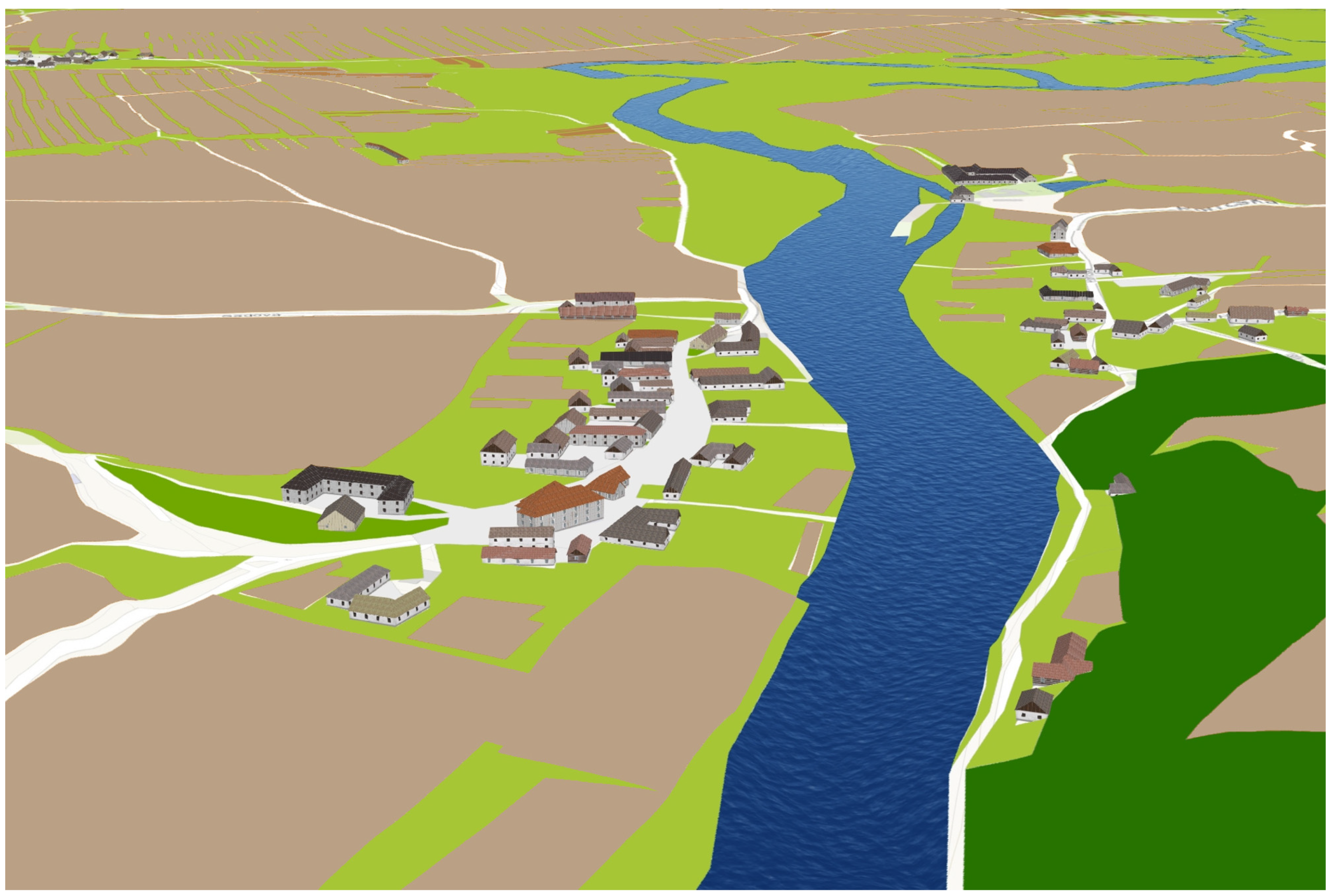
- user-friendly 3D application based on procedural landscape modeling;
- physical models of areas flooded by the 3 largest reservoirs.
4. Discussion
5. Conclusions
Author Contributions
Funding
Institutional Review Board Statement
Informed Consent Statement
Data Availability Statement
Conflicts of Interest
References
- Gregory, I.N.; Geddes, A. Toward Spatial Humanities: Historical GIS and Spatial History; Indiana University Press: Bloomington, IN, USA, 2014. [Google Scholar]
- Trpáková, I. The use of historical sources and their ecological interpretation in the course of almost two centuries—A literature review. J. Landsc. Stud. 2009, 3, 97–119. [Google Scholar]
- Gregory, I.N.; Healey, R.G. Historical GIS: Structuring, mapping and analysing geographies of the past. Prog. Hum. Geogr. 2007, 31, 638–653. [Google Scholar] [CrossRef]
- Schlichting, K. Historical GIS: New ways of doing history. Hist. Methods 2008, 41, 191–196. [Google Scholar] [CrossRef]
- Bitelli, G.; Cremonini, S.; Gatta, G. Cartographic Heritage: Toward unconventional methods for quantitative analysis of pre-geodetic maps. J. Cult. Herit. 2014, 15, 183–195. [Google Scholar] [CrossRef]
- Sahahiri, R.; Arrowsmith, C. Mapping The Historical Places: A case study of Promoting Tourism in Jeddah, The Kingdom of Saudi Arabia. J. Aging Humanit. Arts 2019, 6, 1691315. [Google Scholar] [CrossRef]
- Myers, D. Heritage inventories: Promoting effectiveness as a vital tool for sustainable heritage management. J. Cult. Herit. Manag. Sustain. Dev. 2016, 6, 102–112. [Google Scholar] [CrossRef]
- Blanco, A.; Bustamante, I.; Pascual-Aguilar, J.A. Using old cartography for the inventory of a forgotten heritage: The hydraulic heritage of the Community of Madrid. Sci. Total Environ. 2019, 665, 314–328. [Google Scholar] [CrossRef] [PubMed]
- Gatta, G.; Bitelli, G. A HGIS for the study of waterways: The case of Bologna as ancient city of waters. IOP Conf. Ser. Mater. Sci. Eng. 2020, 949. [Google Scholar] [CrossRef]
- Schmutz, S.; Sendzimir, J. (Eds.) Riverine Ecosystem Management: Science for Governing Towards a Sustainable Future; Springer: Cham, Switzerland, 2018. [Google Scholar]
- Hohensinner, S.; Herrnegger, M.; Blaschke, A.; Habereder, C.; Haidvogl, G.; Hein, T.; Jungwirth, M.; Wei, M. Type-specific reference conditions of fluvial landscapes: A search in the past by 3D-reconstruction. Catena 2008, 75, 200–215. [Google Scholar] [CrossRef]
- Ranzi, R.; Rebuschi, M.; Gentilin, F.; Balistrocchi, M. Geomorphological changes of the Adige river from the Claricini map (1847) and the impact on flood routing. In Proceedings of the 14th International Workshop on Digital Approaches to Cartographic Heritage, Thessaloniki, Greece, 8–10 May 2019; International Cartographic Association: Bern, Switzerland, 2019; pp. 49–58. [Google Scholar]
- Sánchez, J.; Ruiz, A.C.; Navarro, S.; Martín, A.I. Old Maps of Madrid and Interactive Web Applications by National Geographic Institute of Spain. E-Perimetron 2018, 13, 221–235. [Google Scholar]
- Katchadourian, J.C.; López-Herrera, A.-G.; Ruiz-Rodríguez, A.-Á. Proyecto Histocarto: Aplicación de SIGs (georreferenciación y geolocalización) para mejorar la recuperación de la documentación histórica gráfica. Prof. De La Inf. 2019, 28, 1–17. [Google Scholar] [CrossRef] [Green Version]
- Katchadourian, J.C.; Ruiz-Rodríguez, A.-Á.; Alberich-Pascual, J. P Uses and applications of georeferencing and geolocation in old cartographic and photographic document management. Prof. De La Inf. 2018, 27, 202–212. [Google Scholar] [CrossRef]
- Meyer, J.L.; Youngs, Y. Historical Landscape Change in Yellowstone National Park: Demonstrating the Value of Intensive Field Observation and Repeat Photography. Geogr. Rev. 2018, 108, 387–409. [Google Scholar] [CrossRef]
- Brandolini, F.; Reynard, E.; Pelfini., M. Multi-temporal mapping of the Upper Rhone Valley (Valais, Switzerland): Fluvial landscape changes at the end of the Little Ice Age (18th–19th centuries). J. Maps 2020, 16, 212–221. [Google Scholar] [CrossRef] [Green Version]
- Hanušík, V. Laborec riverine landscape between Brekov and Michalovce from the half of 18th century to the half of 19th century. Geogr. Cassoviensis XI 2017, 1, 5–21. [Google Scholar]
- Pătru-Stupariu, I.; Stupariu, M.-S.; Cuculici, R.; Huzui, A. Understanding landscape change using historical maps. Case study Sinaia, Romania. J. Maps 2011, 7, 206–220. [Google Scholar] [CrossRef]
- Pavelková, R.; Frajer, J.; Havlíček, M.; Netopil, P.; Rozkošný, M.; David, V.; Dzuráková, M.; Šarapatka, B. Historical ponds of the Czech Republic: An example of the interpretation of historic maps. J. Maps 2016, 12 (Suppl. 1), 551–559. [Google Scholar] [CrossRef] [Green Version]
- Skaloš, J.; Engstová, B.; Podrázský, V.; Šantrůčková, M.; Trpáková, I. Long-term changes in forest cover 1780–2007 in central Bohemia, Czech Republic. Eur. J. For. Res. 2012, 131, 871–884. [Google Scholar] [CrossRef]
- Bičík, I.; Himiyama, Y.; Feranec, J.; Štych, P. (Eds.) Land Use, Cover Changes in Selected Regions in the World; International Geographical Union Commission on Land Use and Land Cover Change: Prague, Czech Republic, 2012; Volume VII. [Google Scholar]
- Maio, C.V.; Tenenbaum, D.E.; Brown, C.J.; Mastone, V.T.; Gontz, A.M. Application of geographic information technologies to historical landscape reconstruction and military terrain analysis of an American Revolution Battlefield: Preservation potential of historic lands in urbanized settings, Boston, Massachusetts, USA. J. Cult. Herit. 2013, 14, 317–331. [Google Scholar] [CrossRef]
- da Gomes, P.C.C.; Berdoulay, V.V. Imagens na geografía: Importancia da dimensão visual no pensamento geográfico. Cuad. De Geogr. Rev. Colomb. De Geogr. 2018, 27, 356–371. [Google Scholar] [CrossRef]
- Daniels, S.; Cosgrove, D. Introduction: Iconography and landscape. In The Iconography of Landscape. Essays on the Symbolic Representation, Design and Use of Past Environments; Cosgrove, D., Daniels, S., Eds.; Cambridge University Press: Cambridge, UK, 2008; pp. 1–10. [Google Scholar]
- Pietroni, E.; Forte, M.; Pescarin, S.; Rufa, C. The virtual Reconstruction of Archaeological Landscape: From the Fieldwork to the communication through real time applications. The Digital Narrative Museum of the Appia Antica Park. Virtual Retrosp. 2005, 2, 134–139. [Google Scholar]
- Crang, M.; Crang, P.; May, J. (Eds.) Virtual Geographies. Bodies, Space and Relations; Routledge: London, UK, 1999. [Google Scholar]
- Sun, S.; Meng, Q.; Ma, Y.; and Ren, Z. Application of Virtual Reality Technology in Landscape Design. In Proceedings of the 2021 International Symposium on Artificial Intelligence and Its Application on Media (ISAIAM), Xi’an, China, 21–23 May 2021; pp. 91–95. [Google Scholar] [CrossRef]
- Guidi, G.; Frischer, B.; Lucenti, I. Rome Reborn—Virtualizing the ancient imperial Rome. In Workshop on 3D Virtual Reconstruction and Visualization of Complex Architectures; ISPRS: Zürich, Switzerland, 2007. [Google Scholar]
- De Boer, A. Processing old maps and drawings to create virtual historic landscapes. E-Perimetron 2010, 5, 49–57. [Google Scholar]
- Housarová, E.; Pavelka, K.; Šedina, J. Study of Erbil Al-Qala citadel time changes by comparison of historical and contemporary image data. Eur. J. Remote Sens. 2019, 52 (Suppl. 1), 202–208. [Google Scholar] [CrossRef] [Green Version]
- Guidi, G.; Gonizzi Barsanti, S.; Micoli, L.; Malik, U. Accurate Reconstruction of the Roman Circus in Milan by Georeferencing Heterogeneous Data Sources with GIS. Geosciences 2017, 7, 91. [Google Scholar] [CrossRef] [Green Version]
- Brůha, L.; Laštovička, J.; Palatý, T.; Štefanová, E.; Štych, P. Reconstruction of Lost Cultural Heritage Sites and Landscapes: Context of Ancient Objects in Time and Space. ISPRS Int. J. Geo-Inf. 2020, 9, 604. [Google Scholar] [CrossRef]
- Tobiáš, P.; Cajthaml, J.; Krejčí, J. Rapid reconstruction of historical urban landscape: The surroundings of Czech chateaux and castles. J. Cult. Herit. 2018, 30, 1–9. [Google Scholar] [CrossRef]
- Tobiáš, P. BIM, GIS and semantic models of cultural heritage buildings. Geoinformatics FCE CTU 2016, 15, 27–42. [Google Scholar] [CrossRef] [Green Version]
- Bruno, F.; Bruno, S.; De Sensi, G.; Luchi, M.-L.; Mancuso, S.; Muzzupappa, M. From 3D reconstruction to virtual reality: A complete methodology for digital archaeological exhibition. J. Cult. Herit. 2010, 11, 42–49. [Google Scholar] [CrossRef]
- Dolejš, M.; Raška, P.; Pacina, J. The use of 3D immersive virtual reality for visualization of landscape affected by opencast mining. In 14th SGEM GeoConference on Informatics, Geoinformatics and Remote Sensing; STEF92 Technology Ltd.: Sofia, Bulgaria, 2014; Volume 1, pp. 865–872. [Google Scholar]
- Kuča, K.; Malina, O.; Salašová, A.; Weber, M. Historické Kulturní Krajiny České Republiky; Výzkumný ústav Silva Taroucy pro krajinu a okrasné zahradnictví, v.v.i.: Průhonice, Czech Republic, 2020; (In Czech Republic). [Google Scholar]
- Bičík, I.; Kupková, L.; Jeleček, L.; Kabrda, J.; Štych, P.; Janoušek, Z.; Winklerová, J. Land Use Changes in Czechia 1845–2010. In Land Use Changes in the Czech Republic 1845–2010; Springer: Cham, Switzerland, 2015; pp. 95–170. [Google Scholar] [CrossRef]
- Fialová, D.; Chromý, P.; Marada, M. Historickogeografická analýza změn funkčního využití břehů Vltavy (v období od přelomu 18. a 19. století do současnosti). Hist. Geogr. 2007, 34, 307–317, (In Czech Republic). [Google Scholar]
- Fialová, D. Vltava ve službách člověka. Geogr. Rozhl. 2019, 28, 20–21, (In Czech Republic). [Google Scholar]
- Janata, T.; Krejčí, J. Depiction of Line Features on Folded Maps on Example of Old Maps of the Vltava River. In Proceedings of the International Cartographic Association; Copernicus GmbH: Göttingen, Germany, 2019; Volume 2, ISSN 2570-2092. [Google Scholar]
- Kretschmer, I.; Dörflinger, J.; Wawrick, F. Österreichische Kartographie. Wiener Schiften zur Geographie und Kartographie—Band 15; Institut für Geographie und Regionalforschung der Universität Wien: Wien, Austria, 2004. [Google Scholar]
- Hofstätter, E. Beiträge zur Geschichte der Österreichischen Landesaufnahmen; 1. Teil; Bundesamt für Eich-und Vermessungswesen: Wien, Austria, 1989. [Google Scholar]
- Fundamental Base of Geographic Data of the Czech Republic (ZABAGED). Available online: https://geoportal.cuzk.cz/Default.aspx?lng=EN&mode=TextMeta&metadataID=CZ-CUZK-ZABAGED-VP&side=zabaged (accessed on 15 October 2021).
- Cajthaml, J.; Janata, T. Georeferencing of First Military Mapping survey maps in the area of Bohemia using polynomial method. E-Perimetron 2017, 12, 181–188. [Google Scholar]
- Kratochvílová, D.; Cajthaml, J. Using The Automatic Vectorisation Method In Generating The Vector Altimetry Of The Historical Vltava River Valley. Acta Polytech. 2020, 60, 303–312. [Google Scholar] [CrossRef]
- Zimová, R.; Pešťák, J.; Veverka, B. Historical military mapping of the Czech lands–cartographic analysis. In International Conference on Cartography and GIS; ICA: Borovets, Bulgaria, 2006; pp. 1–7. [Google Scholar]
- Molnár, G.; Timár, G.; Biszak, E. Can the First Military Survey maps of the Habsburg Empire (1763–1790) be georeferenced by an accuracy of 200 meters? In 9th International Workshop on Digital Approaches to Cartographic Heritage; International Cartographic Association: Budapest, Hungary, 2014; pp. 127–132. [Google Scholar]
- Kupková, L.; Bičík, I.; Jeleček, L. At the Crossroads of European Landscape Changes: Major Processes of Landscape Change in Czechia since the Middle of the 19th Century and Their Driving Forces. Land 2021, 10, 34. [Google Scholar] [CrossRef]
- Bürgi, M.; Bieling, C.; von Hackwitz, K.; Kizos, T.; Lieskovský, J.; García Martín, M.; Printsmann, A. Processes and driving forces in changing cultural landscapes across Europe. Landsc. Ecol. 2017, 32, 2097–2112. [Google Scholar] [CrossRef] [Green Version]
- Hejmanowska, B.; Glowienka, B.; Michalowska, K.; Mikrut, S.; Kramarczyk, P.; Opalinski, P.; Twardowski, M.; Guidi, G.; Barsanti, S.G.; Micoli, L.; et al. The Comparison of the Web GIS Applications Relevant for 4D Models Sharing. IOP Conf. Ser. Earth Environ. Sci. 2019, 362, 12158. [Google Scholar] [CrossRef]
- Jedlička, K.; Čada, V.; Fiala, R.; Hájek, P.; Janečka, K.; Ježek, J.; Jan, R.; Strejcová, J.; Vichrová, M. Techniques Used for Optimizing 3D Geovisualization of Terezín Memoria. In Proceedings of the 26th International Cartographic Conference Proceedings, Dresden, Germany, 25–30 August 2013; International Cartographic Association: Bern, Switzerland, 2013. [Google Scholar]


| Map | Origin Date | Approx. Scale | Map Type | Number of Map Sheets |
|---|---|---|---|---|
| Carte Ideale de la Moldau | 1768 | 1:28,800 | Concertina book | 14 |
| Darstellung des Moldauflusses | 1st half of 18th century | 1:48,000 | Book | 20 |
| Untitled | 1840s/1850s | 1:2800 | Single sheets | 94 |
| Situations Plan des Moldau Flußes | unknown | 1:22,000 | Two concertina books | 16 |
| Moldau Charte | 1776 | 1:10,500 | Single sheets | 41 |
| Mapping | Origin Date | Scale | Suitable Transformation | Estimated Accuracy [m] |
|---|---|---|---|---|
| First Military Survey | 1764–1768 | 1:28,800 | polynomial (control points) | 200–300 |
| Second Military Survey | 1842–1852 | 1:28,800 | projective (corner points) | 20–30 |
| Third Military Survey | 1874–1880 | 1:25,000 | projective (corner points) | 20–30 |
Publisher’s Note: MDPI stays neutral with regard to jurisdictional claims in published maps and institutional affiliations. |
© 2022 by the authors. Licensee MDPI, Basel, Switzerland. This article is an open access article distributed under the terms and conditions of the Creative Commons Attribution (CC BY) license (https://creativecommons.org/licenses/by/4.0/).
Share and Cite
Krejčí, J.; Cajthaml, J. Historical Vltava River Valley–Various Historical Sources within Web Mapping Environment. ISPRS Int. J. Geo-Inf. 2022, 11, 35. https://doi.org/10.3390/ijgi11010035
Krejčí J, Cajthaml J. Historical Vltava River Valley–Various Historical Sources within Web Mapping Environment. ISPRS International Journal of Geo-Information. 2022; 11(1):35. https://doi.org/10.3390/ijgi11010035
Chicago/Turabian StyleKrejčí, Jiří, and Jiří Cajthaml. 2022. "Historical Vltava River Valley–Various Historical Sources within Web Mapping Environment" ISPRS International Journal of Geo-Information 11, no. 1: 35. https://doi.org/10.3390/ijgi11010035
APA StyleKrejčí, J., & Cajthaml, J. (2022). Historical Vltava River Valley–Various Historical Sources within Web Mapping Environment. ISPRS International Journal of Geo-Information, 11(1), 35. https://doi.org/10.3390/ijgi11010035


