1. Introduction
Since time immemorial, humans have been interested in knowing their environment concisely in order to control and manage everything in a particular territory, from natural elements such as rivers, crop fields or areas frequented by animals for food to artificial and social elements such as the delimitation of their properties, buildings and roads [
1].
All these elements have one characteristic in common: the spatial component. That is why everything around us is susceptible to georeferencing and cartographic representation and therefore to be managed for its knowledge, in the first place, and for its inclusion in decision-making in territorial development, in the second [
2]. In short, it is geoinformation or geographic information that is useful and necessary for knowledge of the territory and its management. The same is true for cultural heritage, since for all types of heritage, information is located in a geographical point, such as tangible assets, or associated with a specific geographical area, such as intangible assets.
Knowledge of heritage is an indispensable fact for optimal territorial development and its management from a cultural approach, which should be based on the local history and customs of the place, especially when the goal is the conservation of memory and cultural identity. In addition, many examples have shown that the application of a heritage management plan based on local history and memory are more successful and better received by citizens and neighbours [
3].
The Sustainable Development Goal (SDG) 11.4 of the United Nations (UN) adopted in 2015 seeks to strengthen efforts to protect and safeguard the world’s cultural and natural heritage [
4], especially heritage located in rural areas, which is often undermined by urban areas.
This paper presents the research undertaken in a typical Central American rural environment in Ecuador, a country full of natural resources and cultural heritage assets, which requires simple tools to manage properly [
5,
6].
A heritage management system should be adapted to tackle the six phases involved in the process of conserving heritage information [
7]. Heritage management begins with the identification of the assets to be conserved (
Figure 1). Subsequently, what is to be conserved is evaluated and assessed, and a diagnosis is carried out to determine the state of conservation of the assets in order to propose a conservation project. The next phase is characterised by the implementation of the proposed conservation project and, finally, its monitoring and follow-up through its operation phase.
It is important to note that, nowadays, the use of new web technologies and geomatics knowledge has made possible the optimal fulfilment of the heritage cycle. Therefore, the main objective is to develop a management system not only for cultural heritage documentation and visualisation, but also for preservation and conservation; monitoring and dissemination; and yielding value and knowledge to society.
In the next sections, the following geoinformation tasks will be presented: the implementation of a geoportal for heritage management and dissemination in Cantón Nabón (Ecuador); design of the heritage geographic data models; geometric and alphanumeric documentation of cultural heritage using geomatics techniques; online 3D geovisualisation of heritage assets; and monitoring of heritage assets using a mobile application.
The paper is structured as follows:
Section 2 introduces the Cantón Nabón in Ecuador as a successful documentation and management case study;
Section 3 deals with the materials and methods, namely content related to the heritage management tool developed in Arches, an open-source software platform for cultural heritage organisations;
Section 4 tackles the results of the case study with a fruitful discussion; and
Section 5 draws some conclusions of the research undertaken.
2. Case Study: Cantón Nabón (Ecuador)
The area or place chosen for the implementation of the geoinformation web system for the management and 3D visualisation of cultural heritage is the Canton (Cantón in Spanish) of Nabón, located in the province of Azuay in Ecuador, as shown in
Figure 2. Nabón is located at an average altitude of 2773 m above mean sea level, and its geographical coordinates are 3°20′19.797″ South and 79°3′56.039″ West (
Plaza Central de Nabón).
A canton in Ecuador is a second-level administrative division, i.e., the country is divided into provinces (24), which in turn are divided into different cantons (221). Within each canton, there are different urban and rural parishes. In the case of Cantón Nabón, in the heart of the Ecuadorian highlands, it is divided into an urban parish (
Nabón) and three rural parishes (
Cochapata, Las Nieves and El Progreso). It also includes indigenous territory made up of four indigenous communities: Shiña, Chunazana, Morasloma and Puca [
8].
The main geographic characteristics of Cantón Nabón are its great territorial dispersion, over an area of approx. 668 km2, and its difficult access and communication between communities. The population of Cantón Nabón is just over 15,000 inhabitants, with only 7% living in urban areas and the rest, 93%, in rural areas.
Precisely because of its geographical location in the highlands, Cantón Nabón has always been a transit or rest area (Tambo)—since pre-colonial times with the Cañaris and later with the Incas, which is why the Qhapaq Ñan or Camino Real was built. The language, Quichua, as well as social organisation, agricultural technologies, and religious rituals were carried over from these times in Nabón. When the Spaniards arrived, they built properties that are still of great heritage value today. This value became evident on 8 December 2005 when the urban area of Nabón was declared a National Heritage Site of the Ecuadorian State. The entire territory of Cantón Nabón has important archaeological remains, cultural traditions, and buildings that make Nabón a place with great cultural, historical, and natural value [
9]. Unfortunately, in spite of this cultural wealth, the territory of Nabón is mainly poor and considered an underdeveloped area at both the provincial and national levels. Therefore, with limited economical budgets, the conservation of cultural heritage is always postponed, even though in the National Ecuadorian Constitution, local municipalities have the right to protect, increment, and disseminate cultural and natural assets. Given this context, the research undertaken here is of great importance for the promotion and demonstration of Nabón’s historical and cultural wealth, which has been forgotten for decades. Thus, Nabón and its canton were chosen to develop the international cooperation research project [
5]. It should be noted that the execution of the research project is part of the established international cooperation between the
Universitat Politècnica de València (UPV) in Spain and the
Universidad del Azuay (UDA) in Ecuador, in collaboration with the
Instituto Nacional de Patrimonio Cultural de Ecuador (National Cultural Heritage Institute of Ecuador, INPC) and the
Gobierno Autónomo Descentralizado (Autonomous Decentralised Government, GAD) of Cantón Nabón [
10].
In relation to the existing heritage assets, they can be classified into immovable assets, movable assets, archaeological assets, intangible assets, and natural assets. By way of example,
Figure 3 shows an asset of each type.
In the group of immovable assets, the houses stand out, especially their facades, which are found both around the central park of Nabón and in the surrounding streets. These have the characteristic of being of vernacular typology, that is to say, with an authentic traditional regional architecture formed by two rectangular floors and with wooden balconies on their facades. Other properties have a great patrimonial value in Cantón Nabón, apart from the houses already mentioned. These properties include religious buildings such as the Central Church of Nabón or the Parish Church of Cochapata.
Regarding the movable heritage, most of the patrimonial elements are found inside the churches and are based on sculptures, but there are also paintings, musical instruments, and various furniture assets. Moreover, they contain altarpieces and religious ornaments and accessories of note.
Cantón Nabón also has a large number of archaeological assets, such as the Dumapara Complex, nestled within the territory of the parish of Cochapata. This complex is made up of visible ruins, a Cañari-Inca cemetery, and the Laguna de los Remedios. It is worth mentioning that the Dumapara archaeological ruins are named after an ancient Cañari chieftain called Duma who fought against the Incas. There are some associated Kallancas (houses) and a lateral Kancha (patio), i.e., a site with large buildings where people of the military or noble class rested on their journey along the Qhapaq Ñan (Royal Road) that runs from Colombia to Chile following the Andes mountain range.
With regard to the Cañari-Inca cemetery, it is regrettable to note the high level of huaquería (robbery) that exists in the area. Huaquería is the action of digging up and dismantling the graves and tombs of the indigenous people of the area. Finally, in the Laguna de los Remedios, there are a large number of metates, archaeological stone elements that were used to grind any type of grain. Likewise, there are also apachetas, elements that were built stone by stone over a long period, where passers-by of the area deposited them as offerings to the gods and/or the deceased.
It is not only necessary to consider material heritage assets such as real estate, movable or archaeological assets, but also immaterial assets such as rituals, festivals, traditions, or illustrious personalities, among others. In Cantón Nabón, there is a great variety of intangible assets at the gastronomic level, such as guinea pigs, tortillas, pork frying, and Chahuarmisqui liquor. It also includes traditional clothing, farming techniques and the illustrious character Comandante Ariel (Jorge Vicente Patiño Aguirre) who was part of the Sandinista Revolution in Nicaragua.
Last but not least, the natural heritage also deserves attention. Cantón Nabón is mainly rural, with a large territorial extension and a vast diversity of native flora and fauna, which means that it possesses a considerable number of natural sites of heritage interest. This project has not focused on this type of heritage yet, giving priority to immovable cultural heritage. Even so, one of the long-term objectives is to document the entire natural heritage of Cantón Nabón. In any case, it has been possible to document the stone beds (Camas de Piedra), a little-explored site in the parish of Cochapata, which has large stones carved by fluvial erosion and pools covered with water, allowing the observation of the different natural waterfalls.
The cultural and natural richness of Nabón has been clearly described; however, for such a small municipality, which faces many different urgencies, cultural heritage management is not an easy task. Consequently, a web-based portal can be used to store all the available heritage assets in a coherent standardised management system in order to register, archive, keep up to date and support heritage decision-making.
3. Materials and Methods
This section presents all the tasks that have been carried out for the implementation of the heritage management system based on the documentation, conservation, monitoring, visualisation, and dissemination of cultural and natural heritage assets. Firstly, the open-source platform Arches, which supports the entire web infrastructure of the project, will be discussed, followed by the creation and management of the heritage data models of this platform. The documentation of the heritage elements with alphanumeric information and geomatic techniques will also be explained. Then, the tasks carried out for the online 3D geovisualisation and its integration in the platform with 3DHOP will be presented. Finally, the tool that will allow the monitoring of heritage assets for their optimal conservation and preservation with Arches Collector will be presented.
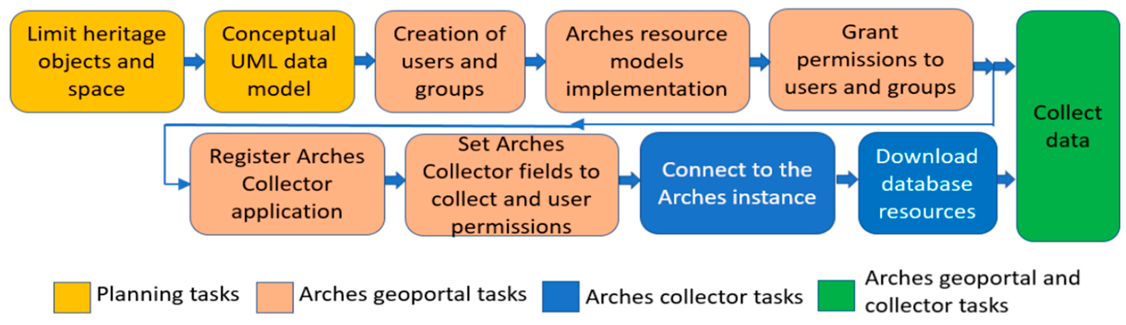
Figure 4 shows the workflow of the main tasks performed in this project.
3.1. Arches System
Arches (
https://archesproject.com—Accessed on 1 November 2021) is a client-server system or application developed by the Getty Conservation Institute (GCI) and the World Monuments Fund (WMF), which is made up of two parts: front-end (client) and back-end (server), which communicate via the Internet. The front-end is a web page on which data can be checked, edited and viewed, while the back-end is where all the logic is installed on the server, which carries out all the data management (
Figure 5). Once installed on a server, it is an integrated computer system that allows for a geoportal with an interactive web viewer [
11]. Geoportals are considered to be the best tool for publishing spatial information as they make it accessible to non-GIS experts [
12,
13,
14]. Through a web browser, Arches allows the management of users and permissions and the creation of data models (or ontologies in Arches terminology) to describe the heritage to be managed, as well as data entry and editing. Arches also has an alphanumeric and spatial search system to discover the documented heritage.
Arches is Open Source Software (OSS), so it is possible to study and customise its code. OSS is increasingly competitive and used [
15,
16]. Arches is primarily a Django application, using PostgreSQL plus PostGIS as a database. It is also used in very large projects that include multiple dependencies and rely on other large OSS projects, such as CouchDB, Celery or Rabbitmq. Arches was born because heritage organisations often have significant resource constraints, and it enables duplicative investments in creating separate inventory systems that address very similar needs [
17].
Since the first release of Arches in 2013 many organisations are using it for heritage management [
18,
19]. In the present project, Arches has been chosen as the heritage management system for Nabón [
20]. The documented elements can be consulted at
https://www.patrimoniocantonnabon.tk (Accessed on 1 November 2021).
Thanks to the availability of the source code, Arches has been customised for this project by changing the welcome page and translating the interface into Spanish. This task has turned out to be quite simple, as it has only been necessary to change certain templates in Django format.
3.2. Data Models
To manage cultural heritage, the CIDOC Conceptual Reference Model (CRM) is implemented. The CIDOC CRM is the outcome of over 20 years of development and maintenance work. Since 2006, it has become an ISO norm and was renewed in 2014 with the identifier ISO 21127:2014 [
21]. This model is a common framework for documenting heritage elements in a standard way, which can be consulted and shared between different systems if appropriate interoperability tools are implemented [
22]. CRM is also known as ontology. Metadata are used to describe, identify, and facilitate the access, usage, and management of (digital) resources. But ontologies define entities at a more abstract level, intending to conceptualise a domain of interest [
23].
Arches (version 5.1) has a package (the Arches Inventory Package, HIP) that creates the data model automatically, and this model follows the ISO 21127:2014 standard. For the creation of the data models in this project, it was initially thought to use the existing ontology in the HIP. The HIP has six data models built into the system with an ontology of more than 6000 attributes from the coded lists available for selection in the more than 50 fields described by these data models. The six data models are: Activity Resource Model, Actor Resource Model, Heritage Resource Group Model, Heritage Resource Model, Historical Event Resource Model, and Information Resource Model.
An analysis of the HIP ontology was carried out where, by default, the language used is English. The ontology is also implemented in other languages such as Mandarin Chinese, Japanese, Polish or Russian, and that is why it is successful in the Anglo-Saxon and Asian world [
6]. The drawback is that the Arches interface and its ontology are not in Spanish, the language used by the second largest number of native speakers (after Mandarin Chinese) [
24]. After investigating this problem and making inquiries with the creators of the platform, we were told that in April 2021 that a working group was being created to develop the ontology and the interface in Spanish. However, its development, revision, and publication would not take place until 2022–2023. For this reason, the HIP ontology has not been used because it is not in Spanish, the language used in Ecuador. It was therefore decided to collaborate with the INPC for the design and implementation of new data models for this project, seeking compatibility with their currently used models.
The INPC provided the necessary data for the design of the data models, as well as their implementation. Finally, it was decided to implement four data models: immovable property, movable property, archaeological property, and intangible property. The design of the data models has been carried out in compliance, at all times, with the ISO21127:2014 standard for “Information and documentation. A reference ontology for the exchange of cultural heritage information”. The implementation of this standard is not mandatory, but it is a compendium of concepts and elements commonly used in heritage management by relevant international institutions.
For the design of the models, the coded lists commonly used by the INPC were studied. Arches does not allow any changes to be made to the models created as soon as a heritage item using this model exists, so the data model must be accurate before the first data is entered. For each of the four heritage data models implemented, a variable number of blocks or classes of main information has been established. In turn, each of these classes is made up of different fields or attributes allowing for more detailed information.
Figure 6 shows an outline of the information classes of the immovable assets data model. The figure shows the properties or attributes of the immovable asset, or real estate, class, and the enumerations. Enumerations are coded lists or the set of possible values in a field. If an enumeration is used in another figure, it is not repeated. The nine implemented information classes are:
Immovable asset: The object that is described. The image field allows the inclusion of an indeterminate number of photographs.
Identifier: Composed of two fields: the code of the INPC element, if it exists, and the denomination.
Keywords: Composed of two fields: one for keywords in English and the other in Spanish.
Location: Geolocation of the property with address, administrative location, coordinates, location sketch and cadastral code.
Asset type: Tenure status of the property.
Typology and Current Use: Typology or style and use of the property.
Assessment: Degree of heritage protection granted by the INPC.
Conservation Status: Describes the state of conservation of the heritage asset for its monitoring through various fields such as the risks to which it is exposed, a description of the existing damage accompanied by photographs, and a recommendation of the required intervention.
Geometric Documentation: Describes the geomatics surveys carried out and contains the 3D links that allow access to the 3D geovisualisation.
Figure 7 shows a schema of the information classes of the movable assets data model. The figure shows the properties or attributes of the movable assets class and the coded lists or the set of possible values in a field. The seven information classes implemented are:
Movable asset: The object that is described.
Identifier: Composed of three fields: the INPC element code—if there is one, the name, and the type of movable asset.
Keywords: Composed of two fields: one for keywords in English and the other in Spanish.
Location: Geolocation of the asset with address, administrative location, and coordinates.
Materials and Techniques: Includes the materials that make up the heritage item and the craft techniques used to create it.
Geometric Documentation: Describes the geomatic surveys carried out and contains the 3D links that allow access to the 3D geovisualisation.
Movable asset type: Describes the movable asset type and the current owner.
Figure 8 shows a schema of the information classes of the archaeological assets data model. The figure shows the properties or attributes of the archaeological asset class and the coded lists or set of possible values in a field. The six information classes implemented are as follows:
Archaeological asset: The object that is described. Any number of images, a description, and the tenure status of the property classification can be associated.
Identifier: Composed of three fields: the code of the INPC element—if it exists, the toponymic name, and the type of archaeological site.
Keywords: Composed of two fields: one for keywords in English and the other in Spanish.
Location: Geolocation of the asset with administrative location, map of the site or coordinates, which are hidden from the user due to the huaquería.
Conservation status: Describes the state of integrity of the heritage item, as well as the risks to which it is exposed, and gives a description of existing damage accompanied by photographs.
Geometric Documentation: Describes the geomatic surveys carried out and contains the 3D links that allow access to the 3D geovisualisation.
Figure 9 shows a schematic of the information classes of the intangible assets data model. The figure shows the properties or attributes of the intangible assets class and the coded lists or set of possible values in a field. The five information classes implemented are as follows:
Intangible asset: The object that is described. It is composed of three fields: an indeterminate number of images, a description, and a date.
Identifier: Composed of seven fields: the code of the INPC element, if it exists; the denomination; the language in which the asset is transmitted; the social group to which it belongs; and the scope, sub-scope and detail of the asset.
Keywords: Composed of two fields: one for keywords in English and the other in Spanish.
Location: Geolocation of the asset with administrative location and coordinates.
Geometric Documentation: Describes the geomatic surveys carried out and contains the 3D links that allow access to the 3D geovisualisation.
3.3. Geometric Documentation
In many cases, heritage geo-information is not documented at all or there is only a brief list with basic alphanumeric details. Cantón Nabón, in particular, is a large and sparsely populated rural area where heritage is scarcely documented. There are a large number of alphanumeric records, the fundamental information to feed the data models, but geometric documentation is non-existent.
The INPC has the power to act in the areas of cultural heritage, for research, technical control of its conservation, and management of archaeological and palaeontological areas, as well as management of natural and anthropic risks affecting the assets. Founded in 1978, the INPC is in charge of researching, conserving, preserving, restoring, exhibiting, and promoting cultural heritage in Ecuador.
As part of its functions, the INPC developed the inventory of heritage assets. This inventory is a list of cultural assets and manifestations that allows the institution to know qualitatively and quantitatively the tangible and intangible assets that belong to the cultural heritage of the Ecuadorian State to build public policies for conservation, preservation, and safeguarding. It is managed by the SIPSE (Ecuadorian Cultural Heritage Information System), as shown in
Figure 10. The inventory records are divided into five models or types: immovable property, movable asset, archaeological property, intangible asset and documentary asset. These data models managed by the INPC are the ones that have been used for the design and implementation of the heritage data models (
Section 3.2).
Furthermore, the alphanumeric documentation is based on the introduction into the database of the heritage information provided by the INPC’s heritage inventory sheets. Geometric heritage documentation has been carried out in Cantón Nabón using geomatics techniques, for subsequent integration into the web system, and 3D geovisualisation (
Section 3.4).
Geometric documentation has been produced mainly by UAV-DAP (Unmanned Aerial Vehicle-Digital Aerial Photogrammetry) with a DJI Phantom 4 Pro 1st generation drone. Some surveying has also been carried out employing terrestrial photogrammetry with a professional NIKON D5000 camera with a 17 mm lens. It should also be noted that a mapathon was carried out with students from the UDA, INPC officials, and members of the government of Nabón to document a large amount of the heritage in the area using their mobile phones. The “3 × 3 rules” adopted by CIPA [
25] were followed at all times for data collection and optimal photographic coverage.
UAV-DAP has shown very rapid development in cultural heritage, especially in archaeological excavation areas and architectural complexes, where it offers a detailed generation of 3D data including the possibility of updating over time [
26]. The Agisoft PhotoScan software was used to process all the photographs and yield metric deliverables in the form of orthoimages and photorealistic 3D models [
27]. All this processing run on a MSI GP75 Leopard 9SD laptop with Intel(R) Core(TM) i7-9750H CPU, 1TB SSD storage and a powerful NVIDIA GeForce(R) graphics card.
Figure 11 shows an example of the geometric documentation executed in Cantón Nabón with a UAV after applying SfM (structure-from-motion) photogrammetry for the Dumapara archaeological ruins. The photographic coverage consisted of 180 digital colour images. The image orientation yielded a reprojection error of 0.45 pixels. From the sparse point cloud and photographic coverage of the site, a dense point cloud with more than 20 million ground points was achieved. After filtering and cleaning the dense point cloud, the 3D model and, eventually, the final textured (photorealistic) 3D model were obtained.
3.4. 3D Geovisualisation
In most cases, geographic information cannot be understood without its own cartographic representation, either in 2D or in 3D. Regarding the former,
Figure 12 shows the linking of the heritage information content with the geovisualisation of the heritage asset through an aerial orthoimage, DTM (digital terrain model) or DSM (digital surface model) derived from UAV-DAP [
26].
Publishing a 3D model on the internet is problematic due to the loading and handling of large archives in the browser. To alleviate this problem, 3D models are generated at various resolutions (
Figure 13) and rendered adaptively [
28], as the resolution is optimised according to the set viewpoint and view distance [
29]. Thanks to current web technologies, geographic phenomena can be visualised via the Internet in 3D, either as a point cloud or as textured 3D models. In the same way, these technologies allow interaction with these 3D models to extract scaled measurements in a user-friendly and personalised way, or on-the-fly cross-sections of the selected XY, XZ, YZ planes with the model.
Figure 13 shows how the model loads progressively until the optimal and complete visualisation is reached, avoiding excessive waiting for the user until the 3D model is fully loaded on the screen.
Geovisualisation is not only the online 3D visualisation through a web viewer. It can also include augmented and/or virtual reality [
30]. Some tests and examples have been carried out with some heritage assets, and work is underway to integrate them into the established web system.
3.5. Monitoring
Geoinformation is not characterised by its unalterable nature. Cultural heritage, which is the basis of geospatial information, is in continuous change due to all the natural and human phenomena to which it is exposed. These phenomena, such as floods, volcanic activity, vandalism and pollution, among others, are risks that in turn affect cultural heritage. In this way, the implementation and use of geomatics techniques make it possible to monitor this geographic heritage information over time, creating an integrated work system from its documentation to its visualisation [
27].
The implemented system allows the information acquired to be stored in different instances (
Figure 14), thus allowing heritage control over time, a fundamental aspect of preventive conservation [
31].
The implemented system facilitates the integration of the preventive conservation cycle into the developed project. This cycle is characterised as an endless loop consisting of four phases: analysis, diagnosis, therapy, and control [
32]. The different phases correspond, respectively, to the search for significant data and information, the individualisation of the causes of damage and deterioration, the choice of corrective measures, and the control of effective interventions (
Figure 15).
As shown in
Figure 15 exemplifying the preventive conservation cycle in the Central Church of Nabón, the heritage property has been documented and analysed. Thanks to the date of the state of conservation, its description, and photographs of the damage, a diagnosis was made. The diagnosis made it possible to recommend intervention with the choice of corrective measures (therapy) and, at a later stage, to carry them out.
Figure 16 shows the monitoring and evolution of the church: its initial state in March 2021, its rehabilitation in August 2021, and its final state in November 2021.
Once the corrective measures have been implemented, the interventions on the heritage property are monitored. This control is carried out with Arches Collector, the mobile application of the integrated system used, which makes it possible to photographically and alphanumerically record and document the heritage asset with its current state of conservation. As it is synchronised with the web system, the database is updated, contributing to the monitoring and evolution of heritage geo-information, an extremely important activity in the field of heritage conservation.
4. Results and Discussion
Geoportals allow the effective integration and management of heritage resources on different assets through standardised web systems and provide society with dynamic access to the geoinformation of its territory.
The wide variety of resources available for the optimal creation of geoportals is well-known, as well as the problems that the professional must face in the design of the graphical interface [
33], taking into account their qualitative and functional requirements. Some of these requirements are the existence of adequate navigation tools for moving through the geospatial data, quick access to the attributes of spatial objects and the possibility of accessing complementary information from other multimedia sources, among others.
There are other cultural heritage information managers, but most of them are focused on the management of museum inventories, archives, libraries, exhibitions, and loans, among others. Few heritage information managers are oriented to heritage georeferencing and management in large areas. An alternative to Arches is the South African Heritage Resources Information System (SHARIS) [
34,
35]. In comparison to SAHRIS, and other implementations, one major advantage of Arches is that it provides source codes and documentation for developers and adopts CIDOC-CRM [
18,
36].
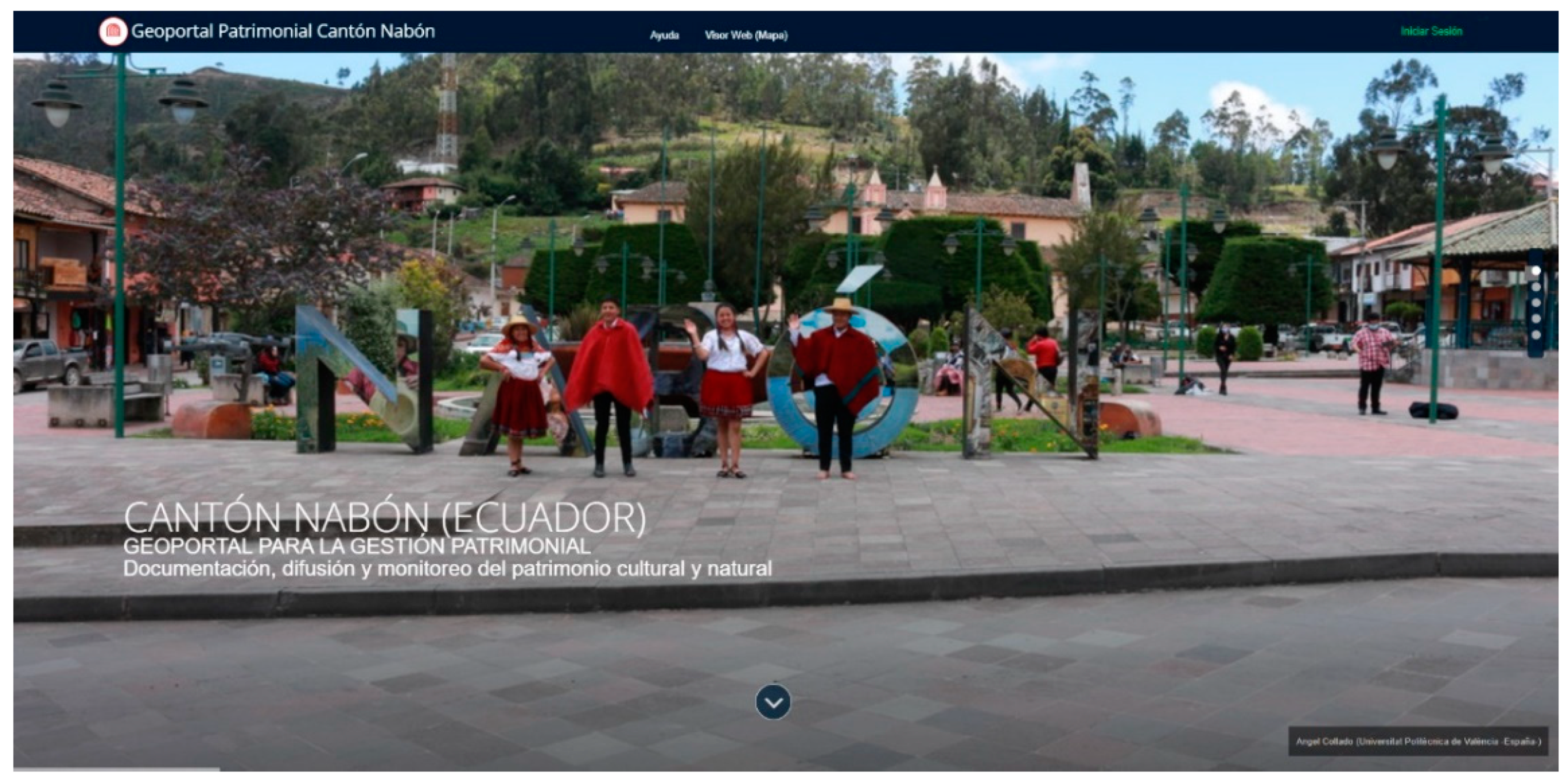
In the present case study, a web geoportal accessible to the whole society (
https://patrimoniocantonnabon.tk/es/—Accessed on 10 November 2021) has been designed and implemented with the Arches platform for heritage management in Cantón Nabón (Ecuador).
Figure 17 shows its home page.
By clicking on the
Web Viewer (
Map) located on the top bar, you can see the heritage assets inserted with the symbology of different coloured dots identified to each of the four models implemented (
Figure 18). The geoinformation of the heritage elements follows the ISO21127:2014 standard for the exchange of heritage information and, moreover, is in Spanish, a language that does not exist in Arches until now (
Section 3.2).
In
Figure 18, most of the central area of the screen is occupied by the interactive viewer, while the list of the heritage assets that make up the geoportal, as well as the possibility of filters and searching conditions for them, is shown on the left-hand side; on the right-hand side, the possibility of changing the background base map, hiding/visualising a layer/data model, and the legend are given. At the level of background base maps, in the installation process, several layers of this type were loaded from the Mapbox map provider.
Figure 19 shows four of the loaded maps: Streets, Satellite Streets, Outdoors, and Dark.
Finally, it is possible to interact with the map and the points shown on the geoportal. When selecting an element represented on the map, a pop-up window appears that allows the identification of that object and the possibility of consulting the data report (Report in a new web tab), as shown in
Figure 20, which can be exported to PDF or printed.
The information included as part of the built assets makes it possible to monitor and control the properties and associated damages suffered over time. This is undoubtedly an important achievement for a country like Ecuador because much of its heritage is made of adobe and is therefore fragile and can be exposed to irreversible damages. The web-based geoinformation system with the methodology and documentation tools previously described has a remarkable impact on the systematization, analysis, and control of built heritage.
Thanks to the implemented web system, a goal of the Ecuadorian National Constitution (Article 23) [
37] related to the research, protection, conservation, restoration, and heritage recovered is developed and achieved. Therefore, the web system allows the heritage custodians and managers to deal with a growing amount of information. In addition, this research also stresses the importance of documentation longevity requiring continuous updating and monitoring as part of the preventive conservation approach suggested by [
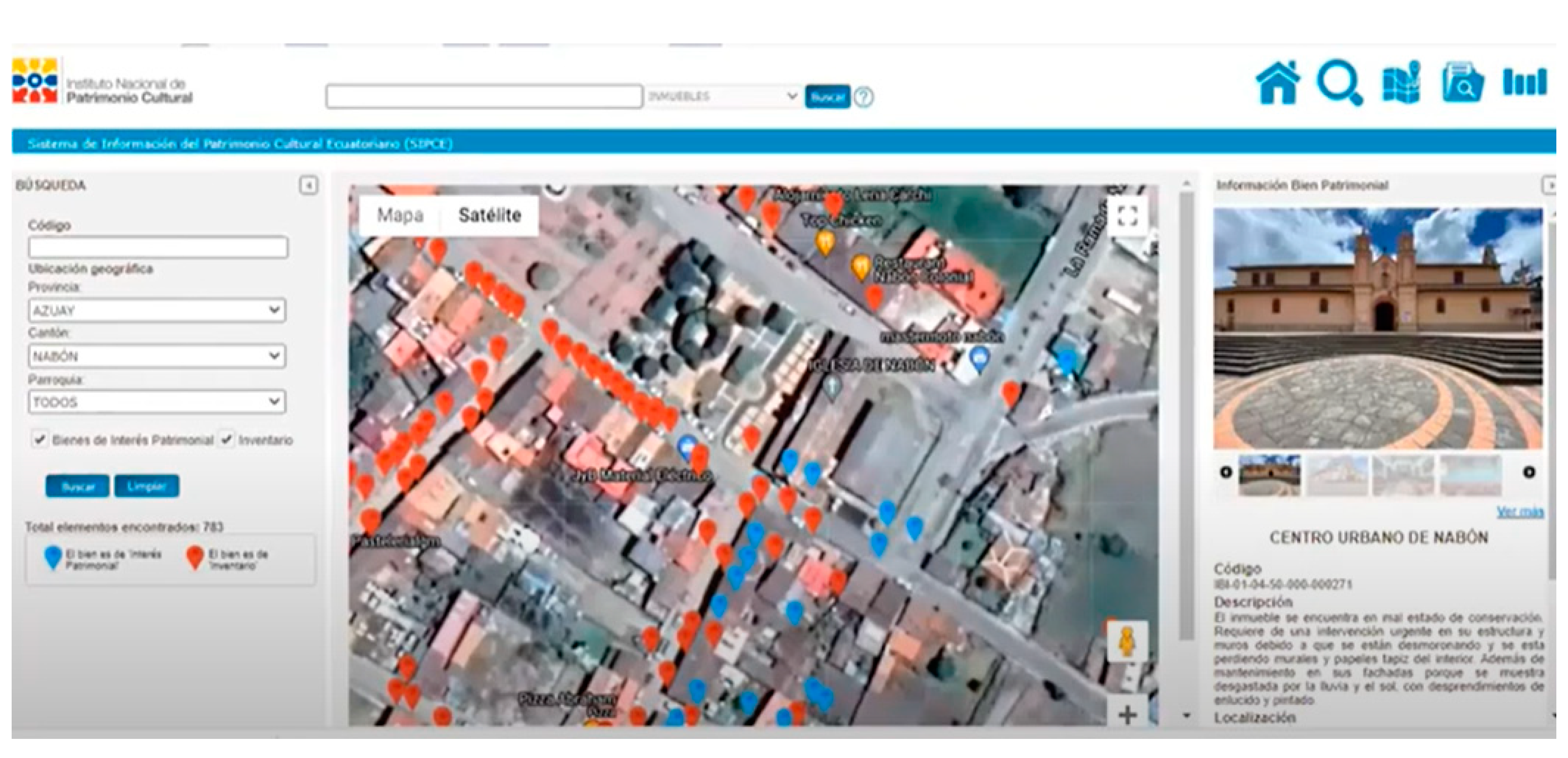
7]. It clearly shows a difference and advantage of the developed system versus the SIPCE (Sistema de Información del Patrimonio Cultural Ecuatoriano), currently used by the INPC [
38].
The implemented web system fulfils the initial expectations of a web-based geoinformation system for heritage management and geovisualisation in Cantón Nabón (Ecuador). It is true that some of the results can be improved, such as the graphical interface of the web viewer and the default Arches interface, which has many features in English that need to be translated into Spanish. Moreover, the symbology of the geoinformation represented on the base maps also deserves to be improved to avoid information overlaps and to be more suitable for a dynamic environment. And the adaption of a geoportal from data sets in the form of PDF datasheets from the INPC is not the best way to keep updating national repositories.
Analysing the results presented, it can also be stated that the creation of an additional natural data model is necessary for complete heritage and environmental management in Cantón Nabón. The addition of touristic products related to cultural tourism could also boost the economy [
39], especially given an emphasis on the archaeological components [
40]. Likewise, in the field of geovisualisation, the implementation of new virtual and augmented reality tools within the proposed system should be further investigated to present and attract attention to heritage assets.
Last but not least, the verification of the optimal performance of the geoportal as a holistic tool to satisfy the heritage management of rural areas is expected to be undertaken once hundreds of assets corresponding to the four data models are integrated into the Cantón Nabón web-based geoinformation system.
5. Conclusions
This paper has presented the different steps to an open-source, web-based geoinformation system for heritage management and geovisualisation of a rural area full of heritage assets, such as Cantón Nabón in the province of Azuay, Ecuador. Arches has been demonstrated to be a powerful open-source heritage management geoportal that allows easy-to-use tools to keep editing, updating, and monitoring heritage assets. Geovisualisation tools in the form of geomatics products, such as interactive photorealistic 3D models, orthoimages and DSM, add value to existing historical heritage resources, not only for local inhabitants but also for national and international visitors who wish to learn, understand, and appreciate a foreign culture. Nevertheless, the web-based geoportal is able to set restrictions for different users (administrators, heritage registered experts, local technicians, and external visitors, among others) to preserve and safeguard assets that might attract huaquería and/or vandalism. Even so, this type of geoinformation tool is of great importance for small municipalities in Ecuador that need a tool to support their technicians in heritage decision-making.
Future development will integrate national heritage data coming straight from the INPC, instead of manual importation of already existing heritage information in the form of imagery, historical sheet records, and national heritage inventories.


