Abstract
The study of gully characteristics is one of the most effective ways to explore the loess landform development in the Loess Plateau of China. However, current studies mostly focus on gullies’ overall characteristics and ignore the different composition of the whole gully system. Therefore, a new perspective is provided in this paper for exploring loess landform development from the population characteristics of the gully system. Firstly, different types of gullies were extracted based on DEM and high-resolution images in three sample watersheds, including hillslope ephemeral gully, bank gully and different-level valley gully. Secondly, population characteristics from the amount, length, age structure and convergent relationship were calculated and analyzed by referring to the biological population in ecology. Finally, the development stages of loess landform in three watersheds were explored based on their population characteristics. The results showed that: (1) The population characteristics, including number density, length density, age structure and convergence, were obviously different in three sample watersheds. (2) The development differences of three watersheds were obtained by synthesizing all population characteristics: Linjiajian was the most developed and oldest watershed, followed by Yangjiaju and then Wangjiagou. (3) The comparison based on the existing soil erosion intensity map and predisposing factors proved that the findings of this paper were more reasonable than that of the traditional hypsometric integral. This research provides a new quantitative-based approach to explore the development degree of loess landform from the gully population, and is a beneficial attempt to combine geomorphology and ecology, further supplementing and improving the study of loess landform development.
1. Introduction
The Loess Plateau in China is known as one of the most valuable geographical regions in the world [1]. After millions of years of transportation and accumulation, the current loess landform was mainly formed under the combined action of wind sedimentation and water erosion [2]. The loess landforms in different development stages, such as loess tableland, loess ridge, loess hill and their mixture, have presented diverse morphology in different regions, leading to a considerable difference in soil and water loss [3,4]. The accurate judgment of the development stage of loess landform is an important focus and has practical significance for soil and water conservation, which improves disaster prevention ability according to local conditions.
In recent years, methods of geochronological dating, loess erosion and geomorphological characteristics have been applied by many scholars to explore the development of loess landforms. Geochronological dating methods, such as 14C [5], optically stimulated luminescence [6], magneto stratigraphy [7] and Zircon U Pb [8], have achieved many significant results in the evolution of loess landforms. In the aspect of loess erosion, many studies have been carried out from erosion processes, soil erosion models, etc. [9,10].
Since the last century, the geomorphological characteristics of loess landforms has been a hot topic in loess research, which is also employed to study the development of landforms [2,4,11]. The initial research of loess landforms’ development was mainly qualitative. The geomorphic cycle theory proposed by Davis (1899) [12] has become a classic theory; that is, geomorphic development experienced three development stages, from a young stage to a mature stage and then an old stage. Besides, Davis considered that loess landforms in different development stages presented diverse morphology. Later, the supporters of geomorphic cycle theory also inherited and developed it from the aspects of climate [13], ebb deltas [14], etc. With the increasingly close connection between geomorphology and mathematics, physics, information science and other related disciplines, the study of geomorphology has transformed from qualitative to quantitative research. Strahler (1952) [15] proposed the hypsometric integral method to quantify Davis’s geomorphic cycle theory, which initiated quantitative research on geomorphic development. On the basis of the hypsometric integral, the characteristics of hypsometric curves, such as kurtosis, skewness and density function, have been proposed by many scholars to promote their studies [16,17,18,19,20].
With the rapid development of photogrammetry, remote sensing technology and geographic information science, the acquisition of high-precision loess topographic data became more convenient, promoting the extraction of loess features [21,22]. On the one hand, a series of terrain parameters are derived based on DEM by calculating the elevation change in a certain analysis window (i.e., 3 × 3 or 5 × 5), such as the average slope gradient, topographic relief, coefficient of elevation variation and surface cutting depth [23,24,25,26]. These terrain parameters present significant differences in different landform zones, which are also applied to explore landform development. On the other hand, loess gullies, as channels of material and energy transportation during loess processes, are the most dynamic, changeable and characteristic units in loess landforms and have become an important focus in loess landform research [27,28,29]. The development of loess gullies directly affects or even determines the regional differences of loess landforms, which indicates that the gully development can broadly reflect the loess landform development. The gully morphology (i.e., gully length, gully depth, gully density, gully cutting depth, vertical gradient and circularity ratio and their relationships) has improved the understanding of the evolution of gully landforms and the occurrence of soil and water loss in the Loess Plateau [30,31,32,33,34,35,36,37].
In summary, the current studies of loess landform development have enriched the understanding of the loess landform. However, we also need to note that: (1) The geochronological dating and loess erosion methods to study loess landform development are the most accurate but rely on accurate field investigation sample data, which are time consuming and labor intensive. Thus, the applicability in the whole Loess Plateau is limited. (2) The hypsometric integral reflects the watershed development from the macro perspective. However, the hypsometric integral reflects watershed development by the remaining material after erosion, which ignores the influences of the underground bedrock surface [38,39]. Thus, it cannot determine whether the differences between two watersheds were caused by different erosion intensities or the underground bedrock surface. (3) Terrain parameters can also describe the differences of loess landform development, but they are local-based and greatly influenced by the analysis window. (4) The loess gully is also applied to reflect landform development, but current studies either mainly focus on all gullies’ overall characteristics or only pay attention to one type of gully and ignore the different composition of the gully system. However, the composition and development of the loess gully system are the essential characteristics of gullies and could provide more details of landform development, which should not be ignored.
Different types of gullies, including rill, ephemeral, bank and valley gully, constitute an organized gully system. By referring to the concept of biological population in ecology and regarding each gully as an object, we believe that the loess gully system with different types of gullies could be regarded as the loess gully population and have proposed the population characteristics of the gully system [40]. This provides a new research idea and the foundation for studying the population characteristics of the loess gully. Based on previous research, this study further applies the population characteristics of the gully system to explore and reveal the different development stages of loess landforms in different watersheds. This study aims to provide a new perspective to explore the development degree of loess landforms from the gully population, and further supplements and improves the study of loess landform development. The main objectives are as follows: (1) calculate the gully system’s population characteristics in three sample watersheds and (2) analyze the development stage of three watersheds.
2. Materials and Methods
2.1. Study Area and Data
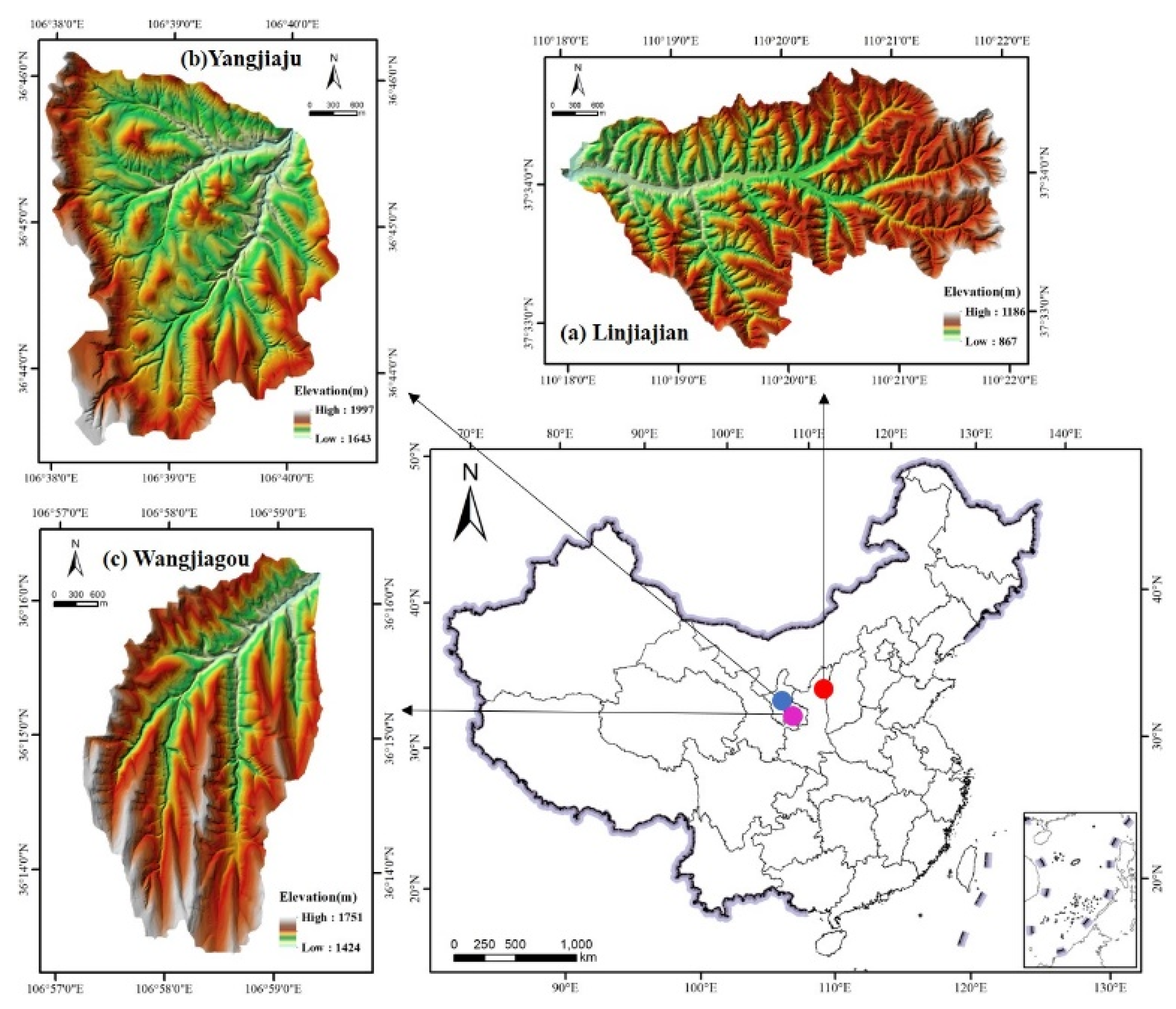
The Loess Plateau is one of the world’s most serious soil erosion regions. A large number of gullies have developed and greatly impacted local life. Three loess watersheds, Linjiajian, Wangjiagou and Yangjiaju, are selected as sample areas to study their loess landform development based on gully population characteristics (Figure 1). Located in Suide County, Shaanxi Province, Linjiajian watershed has a semi-arid continental climate, with an average annual temperature of 8 °C, average rainfall of ~450 mm/year and 1615 sunshine hours annually. The rainy season spans from July to September and accounts for 64.4% of the total annual precipitation, often concentrated in one rainstorm [41]. Wangjiagou is located in the south of Huanxian County, while Yangjiaju is distributed in the northwest of Huanxian County, Gansu Province. Huan County also has a semi-arid continental climate, with an annual average temperature of 6.7–9.2 °C. The rainfall in Huanxian from southeast to northwest is gradually reduced, with annual precipitation being about 400 mm in the south and less than 200 mm in the north [42]. Furthermore, the three watersheds occupy approximately 12 km2 area but have significant differences in their elevation ranges (Table 1). The considerable differences in the physical environments of the three watersheds promote the differences in their gully systems, which indicates that these watersheds are typical and representative in terms of studying their landform development from the population characteristics of the gully system.
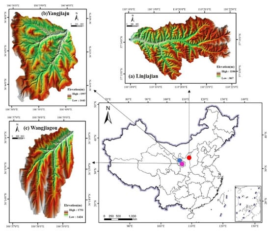
Figure 1.
Location and data of the three selected study areas. (a) digital elevation model of Linjiajian watershed; (b) digital elevation model of Yangjiaju watershed; (c) digital elevation model of Wangjiagou watershed.

Table 1.
Geographical data of the three selected study areas.
The data used in the study mainly included digital elevation models (DEMs), high-resolution images and environment predisposing factors of the three watersheds. DEMs with 5 m spatial resolution were obtained from the National Administration of Surveying, Mapping and Geoinformation of China (NFGIS_DEM). High-resolution images of Linjiajian watershed were obtained from orthophotos with 1 m resolution, which also came from the National Administration of Surveying, Mapping and Geoinformation of China. High-resolution images of Wangjiagou and Linjiajian watersheds were obtained from Google Earth images with 1 m resolution. The coordinate system of CGCS2000 was adopted for DEMs and high-resolution images. Environment predisposing factors have different data sources. The soil constitution dataset came from the Chinese soil map of the second soil survey at a scale of 1:1,000,000, which was divided into three categories, including clay, silt and sand, and presented by their percentage. Soil-type data was derived from the soil map at a scale of 1:500,000, which was developed from the Editorial Committee of Remote Sensing series maps of resources and environment in the Loess Plateau of China. Slope and aspect data were calculated by DEM with 5 m resolution in ArcGIS. Average annual rainfall data was obtained from the Resource and Environment Science and Data Center of the Institute of Geographic Sciences and Natural Resources Research of China. Loess depth data was obtained from Xiong (2019) [43]. Land-use data with 10 m resolution was derived from the widely used FROM-GLC10 dataset, which was developed by Professor Peng Gong’s team from Tsinghua University.
2.2. Methods
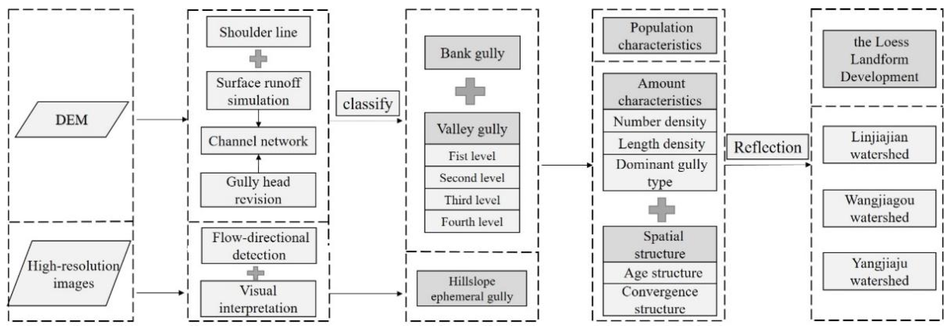
Based on DEMs and high-resolution remote sensing images, the accurate gully system was firstly extracted in three sample watersheds. Population characteristics were then calculated and analyzed to further express the difference of loess landform development in three watersheds (Figure 2).
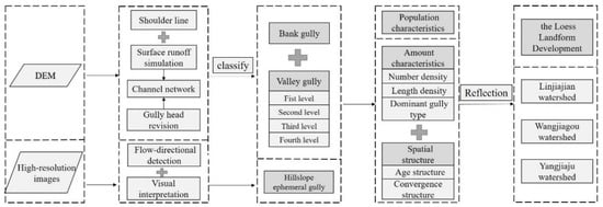
Figure 2.
Workflow of the loess landform development research.
2.2.1. Gully System Extraction and Classification
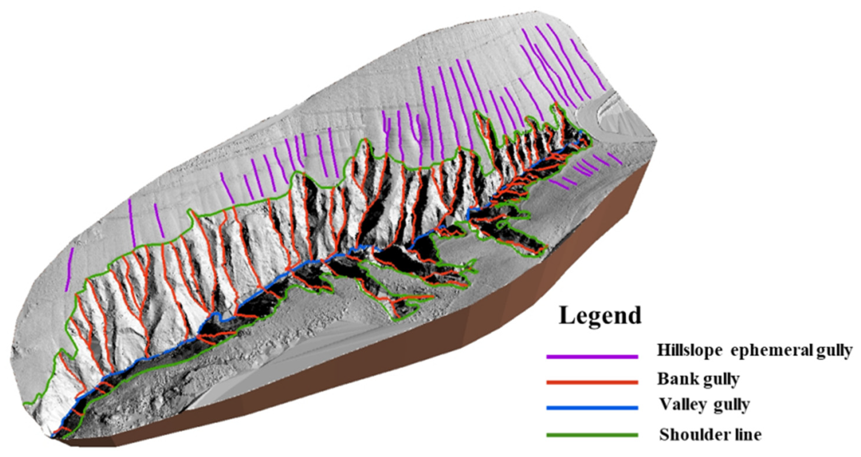
The gully system generally comprises rills, ephemeral gully, bank gully and valley gully [37]. Given that rills are excessively small, easily eliminated by cultivation and have little impact on soil loss, this study does not consider them [44]. The gully system in this study consists of hillslope ephemeral, bank and valley gully (Figure 3), which are the most dynamic, widely distributed and changeable loess gullies in the Loess Plateau.
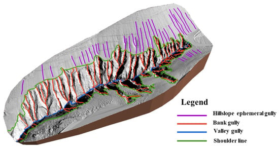
Figure 3.
Typical gully system in a loess hilly area of China.
In morphology, hillslope ephemeral gullies are generally 20–50 cm deep and 30–50 cm wide and are smaller than the bank gully, which are mainly distributed in the area above the shoulder line [40]. Ephemeral gully is too small to be extracted by DEM with 5 m resolution, but it exhibits clear linear features in high-resolution images [45]. Thus, high-resolution remote sensing images are applied to recognize and extract ephemeral gully by the combination of our previous method and visual interpretation and manual digitizing [45]. Bank and valley gullies are mainly extracted by our proposed method [41] on the basis of DEM through hydrologic analysis, and finally verified manually based on high-resolution remote sensing images. Valley gullies are classified into four levels based on their convergence using the Strahler classification rule [46].
2.2.2. Quantitative Characteristics of the Gully System
The gullies at different developmental stages, including hillslope ephemeral, bank and valley gully, comprise a gully system with interconnection and interaction in a drainage area. The different types of gullies in a gully system occupy quantitative proportions and share a convergence under a certain environment. Although the gully population is not a biological population in the strict sense, it has similar basic population characteristics. Therefore, from the aspect of population ecology, each gully is regarded as an object and the composition characteristics of the gully system are mainly described by amount, length, age structure and convergent relationship.
- (1)
- Number Density
Number density (ND) refers to the ratio of gullies’ total number to the watershed area. The number density of gullies can reflect the development degree of gullies to a great extent. The higher the index value, the more gullies in a watershed, the more intensive gully development and the higher the development degree of the watershed. The formula is as follows:
where represents the number density of one valley type, (i = 1, 2, 3, 4, 5) represents the total amount of one gully type and S represents the watershed area.
- (2)
- Length Density
Length density refers to the total length of gully per unit area, which has the same meaning as gully density. Gully length indicates the degree of gully head moving upstream, which is one of the critical manifestations of gully development. The more gully head moves upstream, the longer the gully length. The higher the length density, the more developed the gullies are, the more broken the ground is, the lower the stability of the surface materials and the more serious the gully erosion is in this area. The formula is as follows:
where is the length density of one gully type and is the total length of one gully type.
- (3)
- Dominant Gully Type
A gully randomly extracted from the gully system has a probability of belonging to one type of gully. The dominant gully type refers to that which has the highest probability. Identifying a dominant gully type is of great significance for understanding the current state of a watershed and predicting the future development of the watershed system. It corresponds to the dominant species in the ecological population.
where N is the total amount of all gullies in the gully system and is the total amount of one gully type.
- (4)
- Age Structure
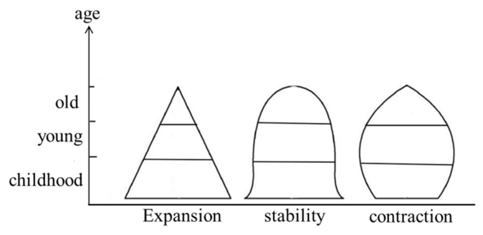
The age structure of a gully system refers to the proportion of different types of gullies in each age stage of the system, which is commonly represented by an age pyramid. The shape of an age pyramid can be used to estimate the current situation and predict the future dynamics of the gully system, which can be divided into three basic types: expansive, stationary and contractive pyramids (Figure 4). The expansive pyramid is characterized by a broad bottom and narrow top, indicating that this population has a high percentage of young groups and will continue to grow. The stationary pyramid is composed of young and old individuals in a similar number, indicating that this population can remain constant. The contractive pyramid is shaped by a narrow bottom and a broad top, inferring that this population has a high percentage of old groups and a low percentage of child groups.
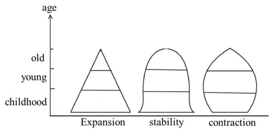
Figure 4.
The schematic diagram of age structure.
- (5)
- Convergence Structure
Convergence structure is the most important embodiment of complex matter and energy flow relation in the gully system and can reflect the relationship between different types of gullies. It is represented by numbers and proportions of gullies converging from low level to high level.
3. Results
3.1. Gully System Extraction Results
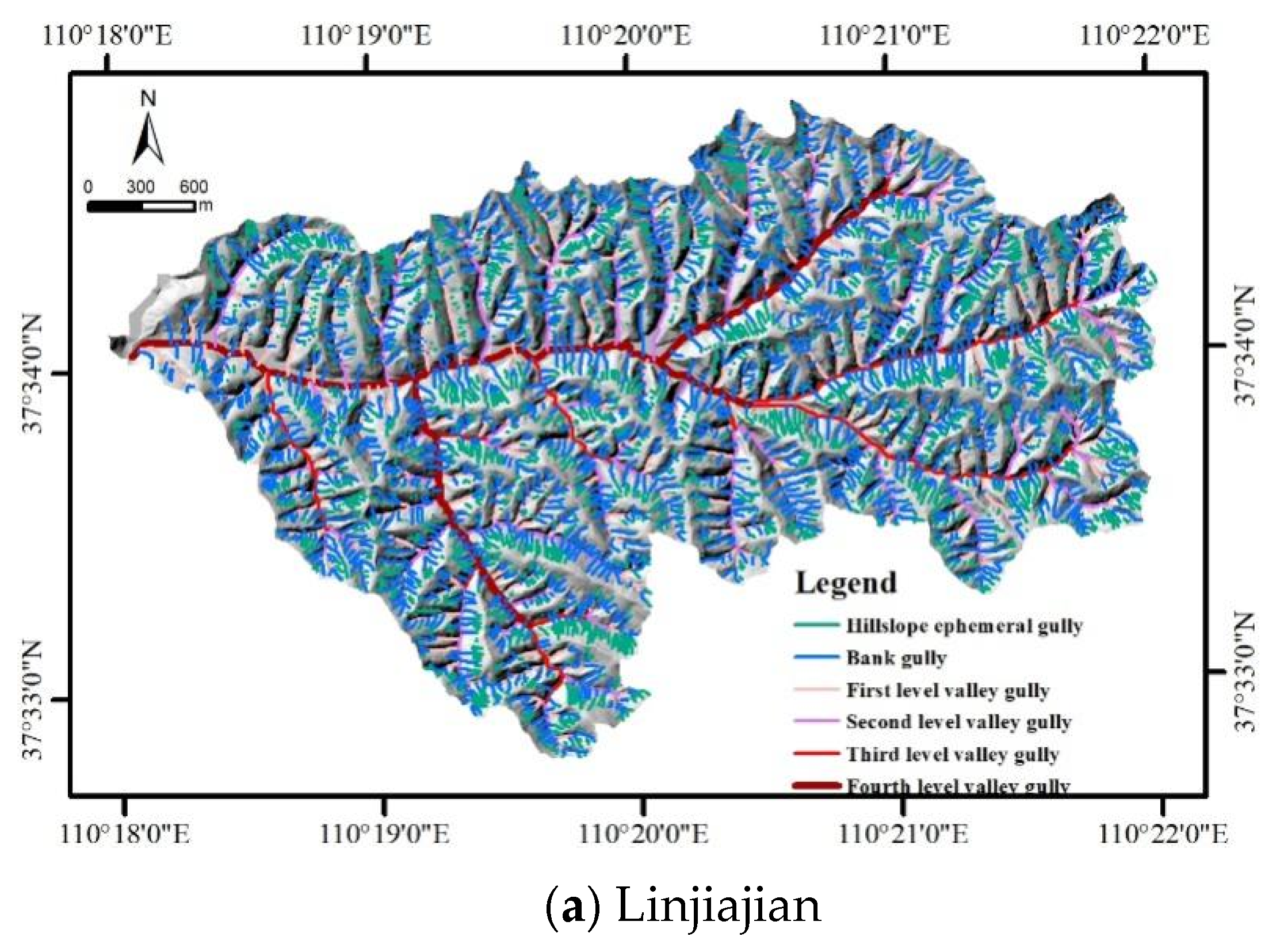
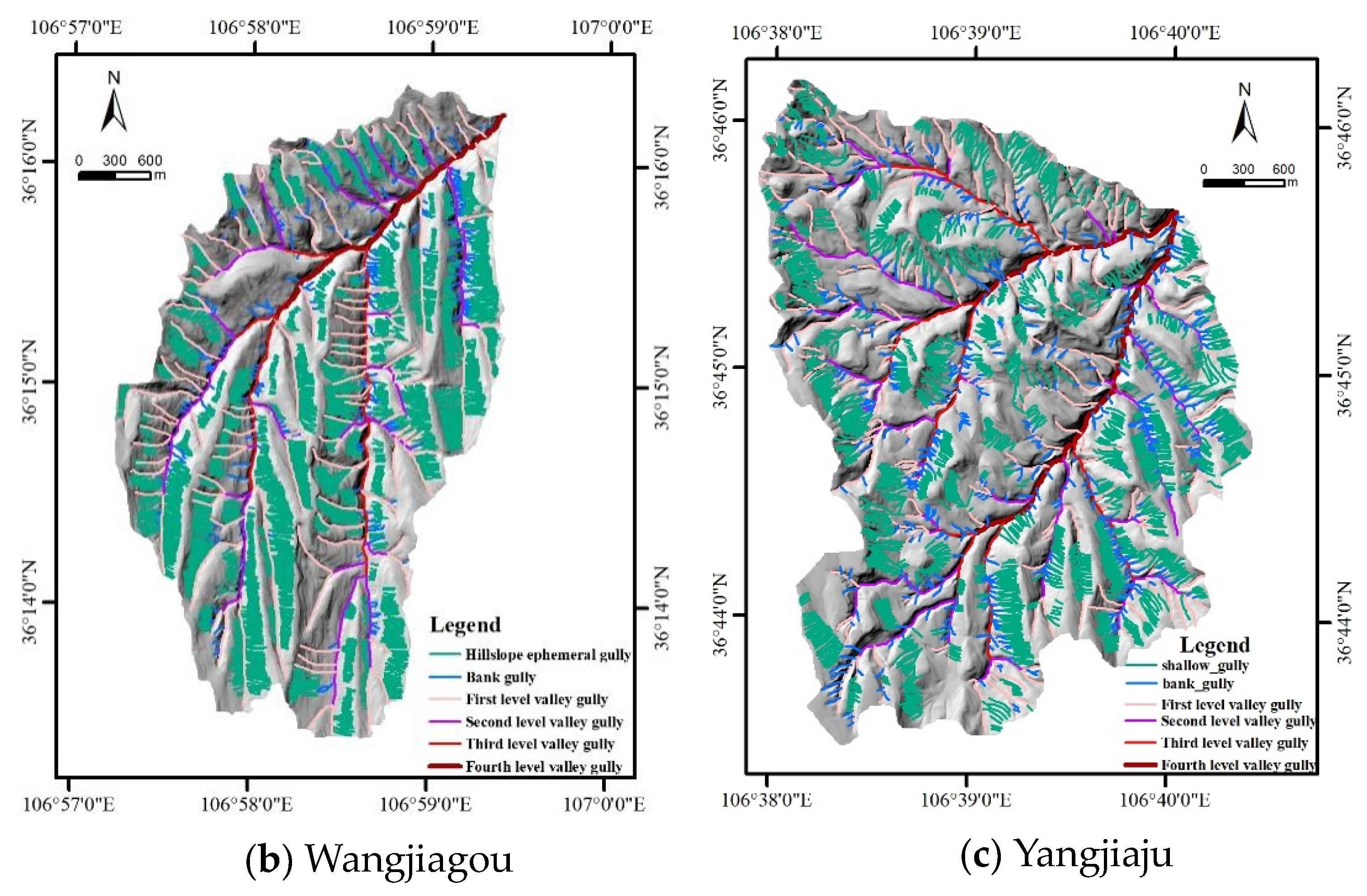
The gully system extraction results of three sample watersheds, which are comprised of hillslope ephemeral gully, bank gully and multilevel valley gully, are shown in Figure 5. The valley gullies are classified into four levels based on the Strahler classification rule. The differences of three sample watersheds’ gullies can be seen from a visual comparison and statistics presented in Table 2. In general, the total number of gullies and the number of different gullies in three watersheds are significantly different. Besides, hillslope ephemeral gullies are always more prolific than bank gullies, and bank gullies are always more prolific than valleys, in the three watersheds.
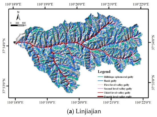
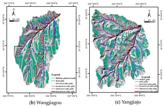
Figure 5.
Results of gully system extraction in the study area for (a) Linjiajian, (b) Wangjiagou and (c) Yangjiaju.

Table 2.
The convergent relationship of the three types of gullies.
In terms of total numbers, Linjiajian developed the most gullies with 4630, followed by Wangjiagou with 4069 and Yangjiaju with only 2992, which was 65% of Linjiajian’s number. Wangjiagou developed 3479 hillslope ephemeral gullies, which was 1.5 times that of Linjiajian (2307) and 1.6 times that of Yangjiagou (2123). With the intensification of water erosion, the hillslope ephemeral gully will be further continuously cut down and widened to become a bank gully, resulting in a decrease in the number of hillslope ephemeral gullies and an increase in the number of bank gullies in the three watersheds. However, regarding the number of bank gullies, Linjiajian totaled 1531, which was almost 5 times that of Wangjiagou (308) and 3.1 times that of Yangjiaju (487). The number of valleys in Linjiajian (396) was also the highest among the three watersheds; indeed, it was more than double both the other two watersheds. In terms of the four different levels of valleys, Linjiajian had the most each time, followed by Yangjiaju and then Wangjiagou. Therefore, Linjiajian, with the most bank and valley gullies, may be the most developed watershed of the three.
3.2. Quantitative Characteristics of the Gully System
3.2.1. Number Density
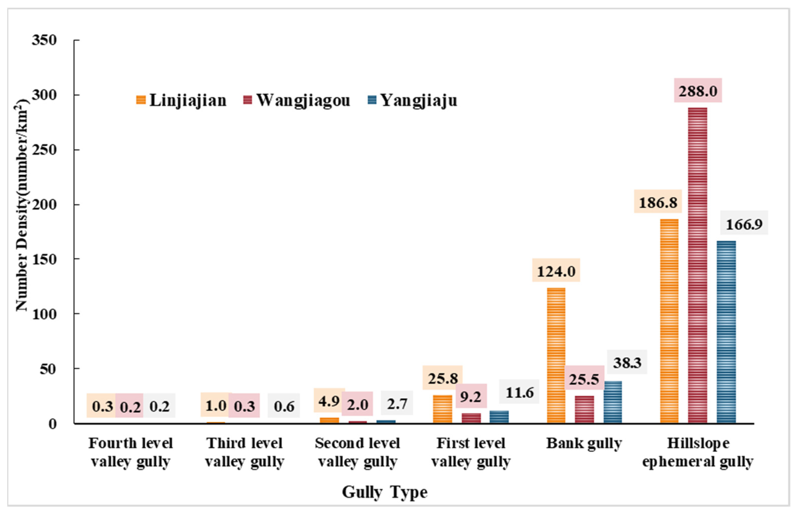
The number density of the three watersheds’ gully systems is shown in Figure 6. The number characteristics of gullies can reflect the development degree of gullies to a great extent. The higher the index value, the more gullies in a watershed, the more intensive the gully development and the higher the development degree of landforms. The total number density of gullies in the Linjiajian watershed was the largest with 342.9 numbers per km2, followed by Wangjiagou (325.2) and Yangjiaju (220.2).
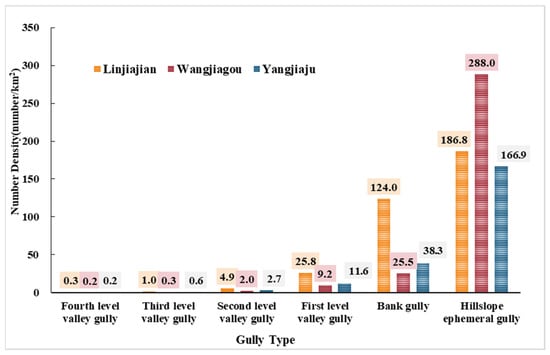
Figure 6.
The number density of the loess gully system for the three watersheds.
The number density of the three watersheds presented a declining trend from hillslope ephemeral gully to bank gully and then to valley gully (including from the first-level valley to the fourth-level valley). Wangjiagou had the highest density of hillslope ephemeral gully with 288 numbers per km2, which was 1.5 times that of Linjiajian (186.8) and 1.7 times that of Yangjiaju (166.9). In the bank gullies number density, Linjiajian was highest with 124 numbers per km2, which was 3.2 times that of Yangjiaju (38.3) and 4.9 times that of Wangjiagou (25.5). In the number density of valley gullies from the first level to the fourth level, Linjiajian was always the largest, followed by Yangjiaju and then Wangjiagou. The erosion intensity to surface keeps increasing from hillslope ephemeral gully to bank gully and then valley gully, representing the development degree from the young to the old. Wangjiagou had the highest hillslope ephemeral gully number density and the lowest bank and valley gully number density, reflecting that it was the youngest and most active gully system of the three watersheds.
3.2.2. Length Distribution
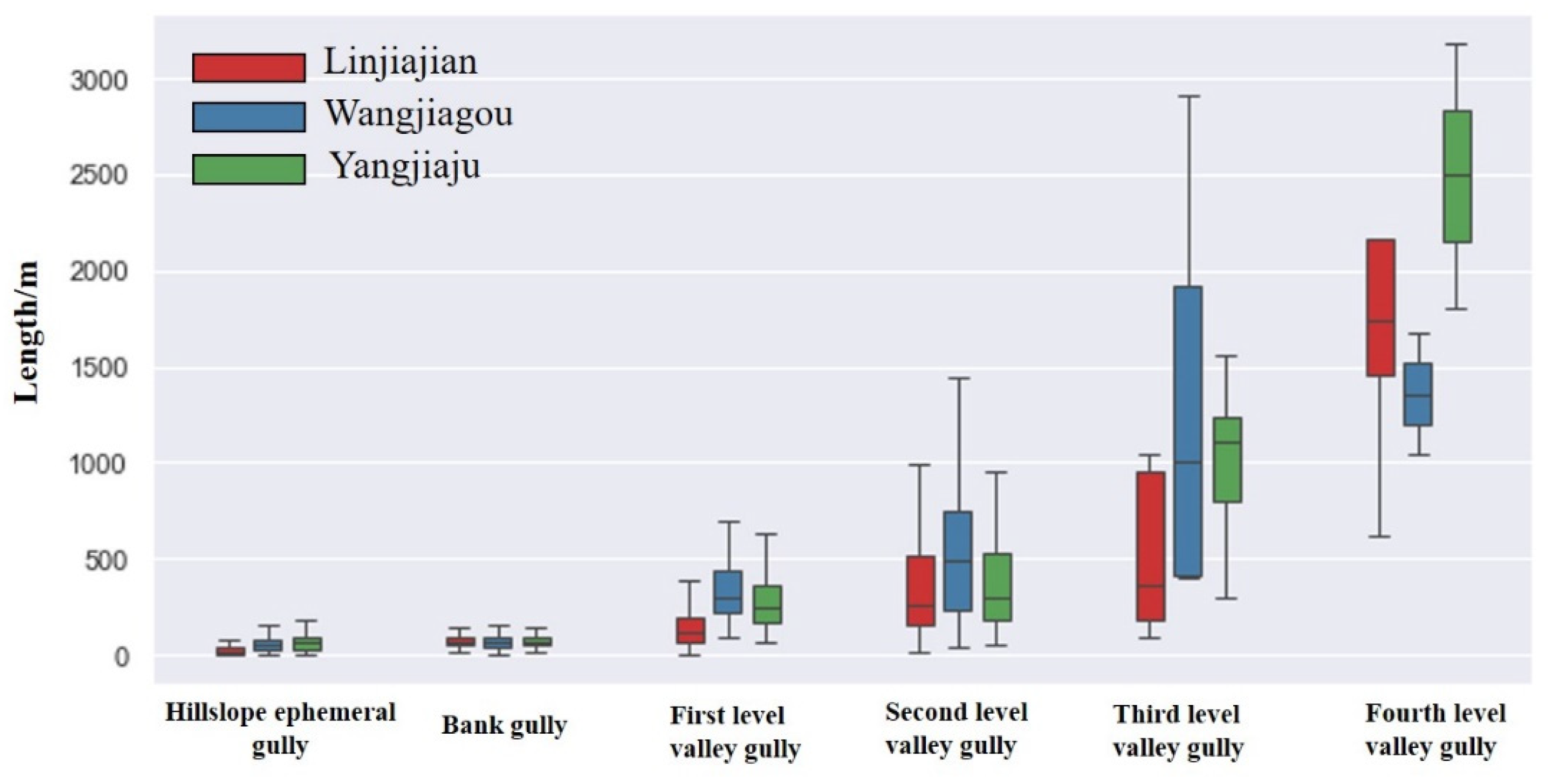
The length of gullies can reveal the development degree to some extent. Different gullies have different lengths. The longer the gully, the higher its development degree, the stronger the surface erosion and the more likely it leads to soil erosion. In Figure 7, an increasing trend of gully length was shown from hillslope ephemeral gully to bank gully and then to valley gully (including from the first-level valley to the fourth-level valley). The length of hillslope ephemeral gully and bank gully in three sample watersheds showed little difference (mainly less than 100 m). The lengths of the first- and second-level valley gully in Wangjiagou were longer than the other two watersheds on the whole. The length of the fourth-level valley gully in three watersheds showed a noticeable difference.
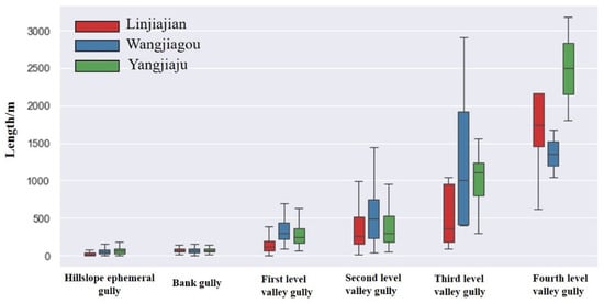
Figure 7.
Length of the loess gully system for the three watersheds.
3.2.3. Length Density
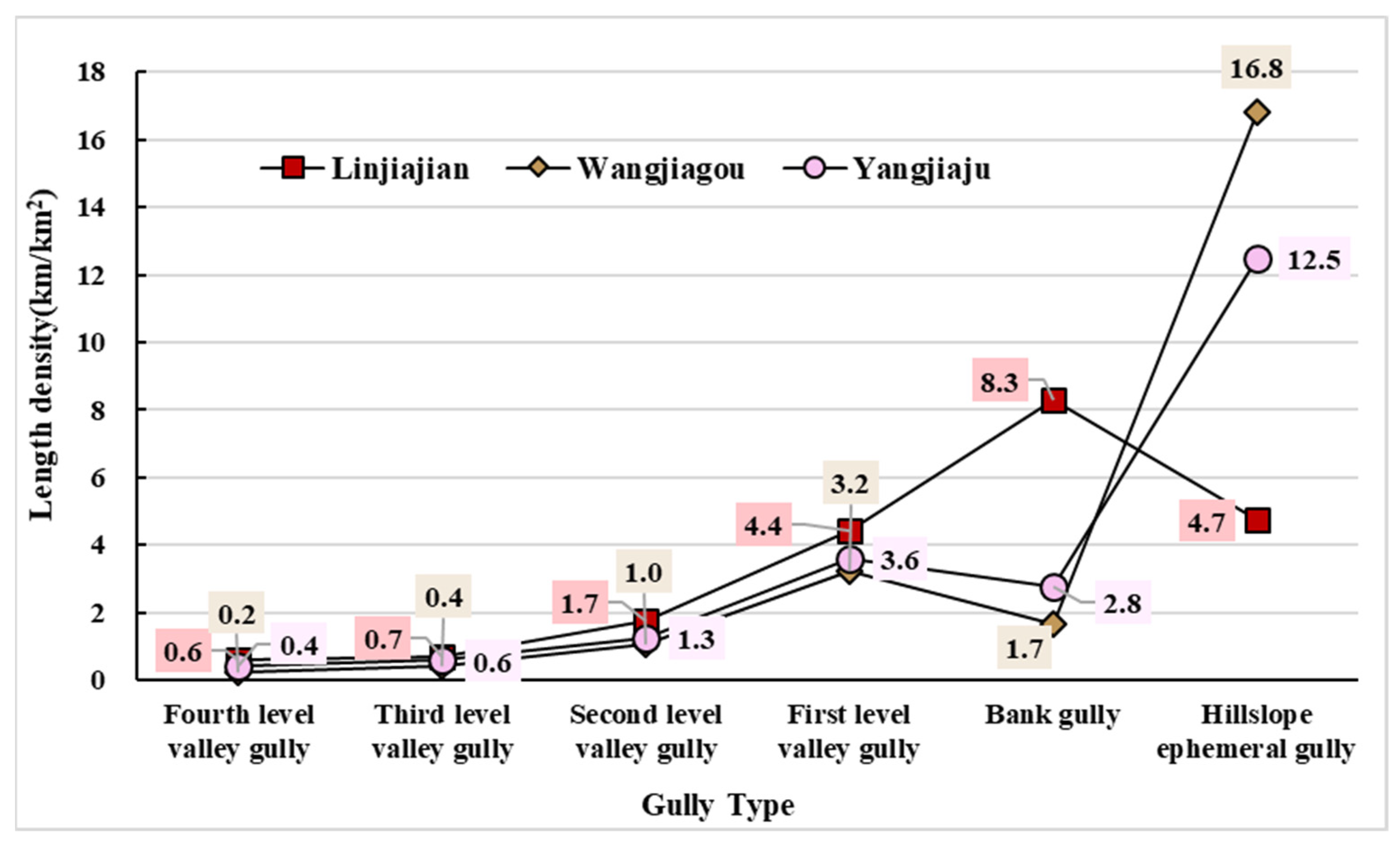
The definition of length density is the same as gully density in the research of soil erosion. A high length density indicates serious soil erosion within a watershed of the Loess Plateau of China. The higher the length density, the more broken the ground and the lower the stability of surface materials. The total length density of all gullies had only a slight difference for the three watersheds, with each being between 20 and 25 km/km2, as shown in Figure 8. However, the length density of different types of gullies varied greatly. For the length density of hillslope ephemeral gully, Wangjiagou ranked first with 16.8 km/km2, followed by Yangjiaju with 12.5 and Linjiajian with 4.7, which was only 28% of Wangjiagou. The bank gully’s length density of 8.3 km/km2 in Linjiajian was the maximum and was 4.9 times that of Wangjiagou (1.7) and 3 times that of Linajiajian (2.8). The length density of all valleys and the four-level valleys of Linjiajian were always higher than Yangjiaju, with Yangjiaju always higher than Wangjiagou. The length density of the first- to fourth-level valley gully was always decreasing. The high length density of hillslope ephemeral gully in Wangjiagou and Yangjiaju indicated that the future increase in the gully length density of the two watersheds will mainly occur by the development of ephemeral gullies.
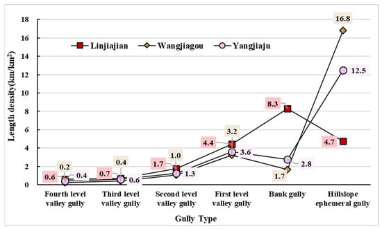
Figure 8.
Length Density of the loess gully system.
3.2.4. Dominant Type
The dominant gully types of three watersheds are shown in Figure 9. It is very obvious that the dominant gully type in the gully system of the three watersheds is hillslope ephemeral gully. According to Formula 3, Linjiajian’s hillslope ephemeral gully value was 0.3613, which was 2.3 times that of bank gully (0.1591). In the Wangjiagou watershed, the value for hillslope ephemeral gully was 0.8212, whereas the values for the bank and valley gullies were less than 0.1. In the Yangjiaju watershed, the value for hillslope ephemeral gully was 0.3060, whereas the bank and valley gully values were significantly less than 0.1. The soil loss and land degradation caused by very abundant ephemeral gullies should not be ignored. In addition, with the increase of soil erosion, a large number of hillslope ephemeral gullies will develop into bank gully and valley gully in the three watersheds in the future.

Figure 9.
The dominant gully type of the loess gully system for (a) Linjiajian, (b) Wangjiagou and (c) Yangjiaju.
3.3. Spatial Structure of the Gully System
3.3.1. Age Structure
Age structure, namely, age composition or age distribution, denotes the proportion of individuals in different age classes and is often represented by an age pyramid. The age pyramid consists of grouping individuals according to their age and is arranged from the young group to the old group. The understanding of the age pyramid is of great importance in revealing the dynamics and productive characteristics of the population. The age pyramid can be divided into three basic types: expansive, stationary and contractive. Gully development also has age differences. In general, most gullies do not appear suddenly, instead growing gradually from small to large scale, especially the large-scale gullies in the Loess Plateau in China. The scale of rill, ephemeral, bank and valley and river gully in a loess gully system increases gradually. Thus, to build the age pyramid of a gully system in the watershed, the hillslope ephemeral gully, bank gully and valley gully are regarded as being a progression from the young to old series. The age pyramid was then constructed using the number and proportion statistics for each age gully.
Figure 10 shows that the age structures of the three watersheds were all expansive pyramids but still had noticeable differences. Linjiajian had the least hillslope ephemeral gully (54.49%) but the most bank gully (36.16%) and valley gully (9.35%), indicating that it was in the oldest stage and had the most development of the three watersheds. Wangjiagou was the youngest watershed of the three with the most hillslope ephemeral gully (88.57%) but the least bank gully (7.84%) and valley gully (3.59%), which indicated that its development was the least of the three watersheds. The amount proportions of hillslope ephemeral gully (75.79%), bank gully (17.39%) and valley gully (6.82%) in Yangjiaju were all in the middle, indicating that its development was in the middle stage of the three watersheds. In summary, Wangjiagou was the youngest of the three watersheds, followed by Yangjiaju and Linjiajian.

Figure 10.
Age structure of the loess gully system for (a) Linjiajian, (b) Wangjiagou and (c) Yangjiaju.
3.3.2. Convergent Relationship
The gullies at different development stages constitute an organic network system. The internal contacts happen in this organic network system at any time, such as the cooperation and transformation of materials and energy. The convergent relationship among different gullies can represent the organic system of a gully network to a great extent. In general, the convergent relationship of a gully system in the Loess Plateau of China involves a young gully converging into an old one.. The rill converges to the hillslope ephemeral gully, the hillslope ephemeral gully then converges to the bank gully and the bank gully converges to the valley gully. However, the phenomenon of some hillslope ephemeral gullies directly converging to the valley gully may occur. The convergent relationships in three watersheds are presented in Table 3, Table 4 and Table 5.

Table 3.
The convergent relationship of three types of gullies.

Table 4.
Convergent relationship from bank gullies to different levels of valley gullies.

Table 5.
Convergent relationship among different levels of valley gullies.
Table 3 shows the convergence of three types of gullies in three watersheds. In general, bank gullies all converged into valley gullies in three watersheds, whereas the hillslope ephemeral gullies’ convergent relationships differed considerably. In terms of the number converging from hillslope ephemeral gullies to bank gullies, Linjiajian watershed ranked first with 1725, accounting for 75% of the total ephemeral gullies. In contrast, only the last 25% of the ephemeral gullies converged into valley gullies. This finding indicated that ephemeral gullies transferred a large quantity of water and soil to bank gullies and will be replaced by bank gullies in the future. Conversely, only 27% of hillslope ephemeral gullies converged into bank gullies, whereas the proportion of ephemeral gullies converging into valley gullies was 70% in Wangjiagou. This finding indicated that a gully will develop slowly in this watershed because valley gully development takes a long time. In the Yangjiaju watershed, the proportion of hillslope ephemeral gullies converging into bank and valley gullies was approximately 50%.
The convergent relationship from bank gully to different levels of valley gully is shown in Table 4. It can be seen that three watersheds have different convergent proportions. The proportions converging from bank gully to fourth-level valley in three watersheds were the smallest at less than 10%. The proportions converging from bank gully to third-level valley were the second-least. However, considerable differences were found in the convergence to first- and second-level valleys. In Linjiajian, bank gullies mainly converged into first-level valley gully, with the proportion being high at 63%. Approximately 22% of bank gullies converged into second-level valley gully, but only 9% converged into third-level valley. This finding indicated that the material and energy of bank gullies mainly contributed to first-level valley gully, and first-level valley gully will develop rapidly in the future in Linjiajian. By contrast, the proportion from bank gully converging into the second level ranked highest at 43%, followed by the first level with a proportion of 31% in the Wangjiagou watershed. The proportion converging into the third level was 23%. In the Yangjiaju watershed, the proportion of bank gullies converging into first and second-level valleys was approximately 35%. Approximately 21% of bank gullies converged into third-level valley gully. The material and energy of the bank gullies in Wangjiagou and Linjiajian were delivered into first- and second-level valley gullies, indicating that both first- and second-level valley gullies will further develop in the future.
Table 5 shows the convergent relationships among different levels of valley gullies. First-level valley gully mainly converged into the second level, and the second level mainly converged into the third level in the three sample watersheds, with proportions high and approximately 70%. All third-level valley gullies converged into the fourth level.
4. Discussion
4.1. Comparison with Hypsometric Integral
As the first quantified indicator of the Davis theory of erosion cycle, the hypsometric integral curve is appealing to express landform development because of its dimensionless parameter that permits the comparison of watersheds regardless of scale issues [47,48]. Thus, it has been commonly applied to distinguish the loess landform at different stages in the Loess Plateau. Therefore, the hypsometric integral curve of the three watersheds is applied to compare our results.
The watershed can be divided into three stages based on hypsometric integral value: the young stage (integral value > 0.6), the mature stage (0.35 < integral value < 0.6) and the old stage (integral value > 0.35). Furthermore, the shape of the hypsometric curve changes from an initial convex to “S” and finally to concave. The hypsometric integral results of the three typical watersheds are shown in Figure 11. According to the hypsometric curve and the integral value, the Wangjiagou watershed has the largest integral value (0.536), indicating that it is the youngest. Linjiajian’s development is in the middle of the three with an integral value of 0.462. Yangjiaju has the lowest integral value (0.407), indicating it is the oldest watershed. However, from the perspective of gully population chrematistics, Wangjiagou is the youngest of the three watersheds, followed by Yangjiaju and then Linjiajian. The Wangjiagou watershed is the youngest from both hypsometric integral and population characteristics, while the development degree of Linjiajian and Yangjiaju is different from the results of population characteristics. This difference may be caused by two aspects. On the one hand, the loess landform development was a combined result of gully erosion, mass erosion and wind erosion. However, the population characteristics of our methods ignore the rill/sheet erosion, mass erosion and wind erosion, which is a deficiency of our method. On the other hand, the hypsometric integral reflects the watershed development by the remaining material after water erosion, which ignores the influences of the underground bedrock surface [38,39]. Therefore, the development degree of Linjiajian and Yangjiaju will be further discussed.

Figure 11.
Hypsometric integral results of the loess gully system for (a) Linjiajian, (b) Wangjiagou and (c) Yangjiaju.
The gully is the main place of soil erosion and the channel of material transportation. The development and evolution of gullies record the process of soil erosion. Conversely, the intensity of soil erosion can also reflect the development of gullies. According to the Map of Soil Erosion Intensity of Loess Plateau [49], Linjiajian watershed is located in Suide country, Shanxi Province, where erosion is very strong (10,000−20,000 t/km2). However, the Yangjiaju watershed is distributed in Huanxian country, Gansu Province, where the erosion is less severe (4000–10,000 t/km2). Therefore, Linjiajian’s soil erosion is more serious than Yangjiaju, indicating that the Linjiajian watershed is more developed from the perspective of erosion. Furthermore, in the gully system, the erosion of the bank and valley gully is stronger than that of the ephemeral gully, indicating that the watershed with higher bank and valley gully density is more fragmented and developed. The number density of the bank and valley gully in Linjiajian is high at 156.1 numbers per km2, which is almost three times that of Yangjiaju (53.5). Moreover, the length density of the bank and valley gully in Linjiajian (15.8 km/km2) is also almost twice that of Yangjiaju (8.6 km/km2). This comparison also indicates that the Linjiajian watershed is more developed than Yangjiaju.
4.2. Predisposing Factors Analysis
Gully erosion is controlled by its physical environment, including geological, lithological and climatic factors. A different physical environment will develop different gullies and form different landforms [50]. Predisposing factors, including soil constitution, soil type, erosion, annual rainfall, loess depth, average slope, aspect and land use, were selected to explore the environmental difference and explain the different development in three watersheds.
It can be seen in Table 6 that soil constitution, soil type and erosion type were the same for all three watersheds. The average annual rainfall of the three watersheds showed an obvious difference. With 479 mm/year, the Linjiajian watershed had the highest average annual rainfall, while Yangjiaju’s average annual rainfall was less than 200 mm/year, indicating that Linjiajian has more serious water erosion than Yangjiaju owning to its higher precipitation. Therefore, the differences in average annual rainfall supported our result that the Linjiajian watershed was more developed and older than Yangjaiju. Linjiajian and Wangjiagou watersheds had a similar loess depth, but the loess depth in Wangjiagou was much deeper than the other two watersheds. The thick loess made gully erosion difficult, which may explain why Wangjiagou was the youngest watershed.

Table 6.
The predisposing factors for the three watersheds.
In addition, the average slope of the Linjiajian watershed was greater than that of the Yangjiaju watershed. The soil loss was more serious in the area with a steeper slope, especially when it rained and made the gully erosion more severe, which may also explain why the gully erosion in Linjiajian was more serious than Yangjiaju. The slope aspect had little difference for the three watersheds (Table 7), where shady slope and semi-shady slope area were approximately 50%. Table 8 shows that Linjiajian was dominated by bareland and also influenced by human beings, while Yangjiaju was dominated by grassland and bareland without human impact, indicating that the Linjiajian watershed was more likely to experience soil erosion.

Table 7.
The slope aspect in the three watersheds.

Table 8.
The land use in the three watersheds.
In summary, the predisposing factors in the three watersheds were different, more or less. The development differences in the three watersheds could be obviously distinguished by differences in average annual rainfall, loess depth, slope and land use.
5. Conclusions
This study attempts to apply population characteristics of the loess gully system to explore and reveal the development degree of the loess landform. The development differences of three sample watersheds were analyzed from their population characteristics. The results were as follows: (1) Population characteristics, including number density, length density, age structure and convergence, were obviously different in the three sample watersheds. (2) The age structures of the three watersheds were all expansive pyramids, while the watershed development degrees were shown to differ by synthesizing all population characteristics: Linjiajian was the most developed and the oldest watershed, followed by Yangjiaju and then Wangjiagou. (3) The comparison analysis based on the existing soil erosion intensity map proved the result of this study was more reasonable than that of the traditional hypsometric integral. Moreover, the differences in the predisposing factors, including average annual rainfall, slope and land use, also verified the development differences of the three watersheds by gully population characteristics.
On the basis of this analysis, we believe that the population characteristics of the loess gully system provide a new perspective to explore the development of loess landform and that its reasonability has been proved. This not only supplements and improves the study of loess landform development, but also has practical significance for soil and water conservation. However, this method mainly focuses on gully erosion and ignores the rill/sheet erosion, mass erosion and wind erosion in the loess landform, which is a shortcoming and needs more consideration in the future. Moreover, the temporal dynamic change of some watersheds will be further explored by gully population characteristics to deepen the loess landform development.
Author Contributions
Conceptualization, Xin Yang and Ling Yang; methodology, Xin Yang and Jiaming Na; software, Ling Yang; validation, Xin Yang and Jiaming Na; formal analysis, Ling Yang; investigation, Jiaming Na; resources, Ling Yang; data curation, Ling Yang; writing—original draft preparation, Ling Yang; writing—review and editing, Xin Yang and Ling Yang; visualization, Ling Yang; supervision, Jiaming Na; project administration, Xin Yang; funding acquisition, Xin Yang. All authors have read and agreed to the published version of the manuscript.
Funding
This research was funded by the National Natural Science Foundation of China (Grant Nos. 41930102 and 41771415) and the Priority Academic Program Development of Jiangsu Higher Education Institutions: (Grant Nos. 164320H116).
Institutional Review Board Statement
Not applicable.
Informed Consent Statement
Not applicable.
Data Availability Statement
Data from this research will be available upon request to the authors.
Conflicts of Interest
The authors declare no conflict of interest.
References
- Xiong, L.; Tang, G.; Yuan, B.; Lu, Z.; Li, F.; Zhang, L. Geomorphological inheritance for loess landform evolution in a severe soil erosion region of Loess Plateau of China based on digital elevation models. Sci. China Earth Sci. 2014, 57, 1944–1952. [Google Scholar] [CrossRef]
- Tang, G.; Li, F.; Liu, X.; Long, Y.; Yang, X. Research on the slope spectrum of the Loess Plateau. Sci. China Ser. E Technol. Sci. 2008, 51, 175–185. [Google Scholar] [CrossRef]
- Li, S.; Xiong, L.; Tang, G.; Strobl, J. Deep learning-based approach for landform classification from integrated data sources of digital elevation model and imagery. Geomorphology 2020, 354, 107045. [Google Scholar] [CrossRef]
- Xiong, L.; Tang, G.; Yang, X.; Li, F. Geomorphology-oriented digital terrain analysis: Progress and perspectives. J. Geogr. Sci. 2021, 31, 456–476. [Google Scholar] [CrossRef]
- Maat, P.B.; Johnson, W.C. Thermoluminescence and new 14C age estimates for late Quaternary loesses in southwestern Nebraska. Geomorphology 1996, 17, 115–128. [Google Scholar] [CrossRef]
- Lai, Z.-P.; Wintle, A.G. Locating the boundary between the Pleistocene and the Holocene in Chinese loess using luminescence. Holocene 2006, 16, 893–899. [Google Scholar] [CrossRef]
- Pan, B.; Hu, Z.; Wang, J.; Vandenberghe, J.; Hu, X. A magnetostratigraphic record of landscape development in the eastern Ordos Plateau, China: Transition from Late Miocene and Early Pliocene stacked sedimentation to Late Pliocene and Quaternary uplift and incision by the Yellow River. Geomorphology 2011, 125, 225–238. [Google Scholar] [CrossRef]
- Wang, X.; Ayers, J.C.; Katsiaficas, N.J. Zircon geochronology of loess and alluvial sediment: Implications for provenance of modern soils of Middle Tennessee. In Proceedings of the AGU Fall Meeting, San Francisco, CA, USA, 15–19 December 2014. pp. EP21D-3569. [Google Scholar]
- Qiang-Guo, C. Soil erosion and management on the Loess Plateau. J. Geogr. Sci. 2001, 11, 53–70. [Google Scholar] [CrossRef]
- Li, P.; Mu, X.; Holden, J.; Wu, Y.; Irvine, B.; Wang, F.; Gao, P.; Zhao, G.; Sun, W. Comparison of soil erosion models used to study the Chinese Loess Plateau. Earth-Sci. Rev. 2017, 170, 17–30. [Google Scholar] [CrossRef] [Green Version]
- Tang, G.; Song, X.; Li, F.; Zhang, Y.; Xiong, L. Slope spectrum critical area and its spatial variation in the Loess Plateau of China. J. Geogr. Sci. 2015, 25, 1452–1466. [Google Scholar] [CrossRef] [Green Version]
- Davis, W.M. The geographical cycle. In Climatic Geomorphology; Palgrave: London, UK, 1973; pp. 19–50. [Google Scholar]
- Miller, A.A. Climate and the geomorphic cycle: Address to the Geographical Association. Geography 1961, 46, 185–197. [Google Scholar]
- Oertel, G.F. Geomorphic cycles in ebb deltas and related patterns of shore erosion and accretion. J. Sediment. Res. 1977, 47, 1121–1131. [Google Scholar]
- Strahler, A.N. Hypsometric (area-altitude) analysis of erosional topography. Geol. Soc. Am. Bull. 1952, 63, 1117–1142. [Google Scholar] [CrossRef]
- Pike, R.J.; Wilson, S.E. Elevation-relief ratio, hypsometric integral, and geomorphic area-altitude analysis. Geol. Soc. Am. Bull. 1971, 82, 1079–1084. [Google Scholar] [CrossRef]
- Tanner, W.F. Examples of departure from the Gaussian in geomorphic analysis. Am. J. Sci. 1959, 257, 458–460. [Google Scholar] [CrossRef]
- Scheidegger, A.E. Theoretical Geomorphology; Springer: Berlin/Heidelberg, Germany, 2012. [Google Scholar]
- Evans, I.S. General geomorphometry, derivatives of altitude, and descriptive statistics. In Spatial Analysis in Geomorphology; Routledge: Abington-on-Thames, UK, 2019; pp. 17–90. [Google Scholar]
- Harlin, J.M. Statistical moments of the hypsometric curve and its density function. J. Int. Assoc. Math. Geol. 1978, 10, 59–72. [Google Scholar] [CrossRef]
- Li, S.; Hu, G.; Cheng, X.; Xiong, L.; Tang, G.; Strobl, J. Integrating topographic knowledge into deep learning for the void-filling of digital elevation models. Remote Sens. Environ. 2022, 269, 112818. [Google Scholar] [CrossRef]
- Lazzari, M. High-resolution LiDAR-derived DEMs in hydrografic network extraction and short-time landscape changes. In Proceedings of the International Conference on Computational Science and Its Applications, Cagliari, Italy, 1–4 July 2020; pp. 723–737. [Google Scholar]
- Cheng, H.; Zou, X.; Wu, Y.; Zhang, C.; Zheng, Q.; Jiang, Z. Morphology parameters of ephemeral gully in characteristics hillslopes on the Loess Plateau of China. Soil Tillage Res. 2007, 94, 4–14. [Google Scholar] [CrossRef]
- Liu, Y.; Cao, J.; Wang, L.; Fang, X.; Wagner, W. Regional features of topographic relief over the Loess Plateau, China: Evidence from ensemble empirical mode decomposition. Front. Earth Sci. 2020, 14, 695–710. [Google Scholar] [CrossRef]
- Hughes, M.W.; Schmidt, J.; Almond, P.C. Automatic landform stratification and environmental correlation for modelling loess landscapes in North Otago, South Island, New Zealand. Geoderma 2009, 149, 92–100. [Google Scholar] [CrossRef]
- Zhao, W.-F.; Xiong, L.-Y.; Ding, H.; Tang, G.-A. Automatic recognition of loess landforms using Random Forest method. J. Mt. Sci. 2017, 14, 885–897. [Google Scholar] [CrossRef]
- Willett, S.D.; McCoy, S.W.; Perron, J.T.; Goren, L.; Chen, C.-Y. Dynamic reorganization of river basins. Science 2014, 343, 1116–1126. [Google Scholar] [CrossRef]
- Li, C.; Li, F.; Dai, Z.; Yang, X.; Cui, X.; Luo, L. Spatial variation of gully development in the loess plateau of China based on the morphological perspective. Earth Sci. Inform. 2020, 13, 1103–1117. [Google Scholar] [CrossRef]
- Valentin, C.; Poesen, J.; Li, Y. Gully erosion: Impacts, factors and control. Catena 2005, 63, 132–153. [Google Scholar] [CrossRef]
- Li, Z.; Zhang, Y.; Zhu, Q.; Yang, S.; Li, H.; Ma, H. A gully erosion assessment model for the Chinese Loess Plateau based on changes in gully length and area. Catena 2017, 148, 195–203. [Google Scholar] [CrossRef]
- Wu, H.; Xu, X.; Zheng, F.; Qin, C.; He, X. Gully morphological characteristics in the loess hilly-gully region based on 3D laser scanning technique. Earth Surf. Process. Landf. 2018, 43, 1701–1710. [Google Scholar] [CrossRef]
- Guan, Y.; Yang, S.; Zhao, C.; Lou, H.; Chen, K.; Zhang, C.; Wu, B. Monitoring long-term gully erosion and topographic thresholds in the marginal zone of the Chinese Loess Plateau. Soil Tillage Res. 2021, 205, 104800. [Google Scholar] [CrossRef]
- Qin, C.; Zheng, F.; Xu, X.; Wu, H. Active stage gully morphological characteristics in the loess hilly-gully region based on 3D laser scanning technique. Earth Surf. Process. Landf. 2017, 43. [Google Scholar]
- Li, J.; Xiong, L. Combined gully profiles for expressing surface morphology and evolution of gully landforms. Front. Earth Sci. 2019, 13, 551–562. [Google Scholar] [CrossRef]
- Na, J.; Ding, H.; Zhao, W.; Liu, K.; Tang, G.; Pfeifer, N. Object-based large-scale terrain classification combined with segmentation optimization and terrain features: A case study in China. Trans GIS. 2021, 25, 2939–2962. [Google Scholar] [CrossRef]
- Huang, X.; Tang, G.; Zhu, T.; Ding, H.; Na, J. Space-for-time substitution in geomorphology. J Geogr Sci. 2019, 29, 1670–1680. [Google Scholar] [CrossRef] [Green Version]
- Na, J.; Yang, X.; Dai, W.; Li, M.; Xiong, L.; Zhu, R.; Tang, G. Bidirectional DEM relief shading method for extraction of gully shoulder line in loess tableland area. Phys. Geogr. 2018, 39, 368–386. [Google Scholar] [CrossRef]
- Xiong, L.-Y.; Tang, G.-A.; Li, F.-Y.; Yuan, B.-Y.; Lu, Z.-C. Modeling the evolution of loess-covered landforms in the Loess Plateau of China using a DEM of underground bedrock surface. Geomorphology 2014, 209, 18–26. [Google Scholar] [CrossRef]
- Xiong, L.Y.; Tang, G.A.; Strobl, J.; Zhu, A.X. Paleotopographic controls on loess deposition in the Loess Plateau of China. Earth Surf. Process. Landf. 2016, 41, 1155–1168. [Google Scholar] [CrossRef]
- Na, J.; Yang, X.; Tang, G.; Dang, W.; Strobl, J. Population characteristics of loess gully system in the Loess Plateau of China. Remote Sens. 2020, 12, 2639. [Google Scholar] [CrossRef]
- Yang, X.; Na, J.; Tang, G.; Wang, T.; Zhu, A. Bank gully extraction from DEMs utilizing the geomorphologic features of a loess hilly area in China. Front. Earth Sci. 2019, 13, 151–168. [Google Scholar] [CrossRef]
- Xiaoyan, W.; Fujiang, H.; Zhibiao, N. Grazing systems on loess soils: Options in Huanxian county, Gansu province. In Development of Sustainable Livestock Systems on Grasslands in North-Western China; ACIAR Proceedings No. 134; Australian Centre for International Agricultural Research: Canberra, ACT, Australia, 2011; pp. 46–57. [Google Scholar]
- Xiong, L.-Y.; Tang, G.-A. Reconstruction of the loess underlying paleotopography for loess landform inheritance. In Loess Landform Inheritance: Modeling and Discovery; Springer: Berlin/Heidelberg, Germany, 2019; pp. 75–133. [Google Scholar]
- Kumawat, A.; Yadav, D.; Samadharmam, K.; Rashmi, I. Soil and water conservation measures for agricultural sustainability. In Soil Moisture Importance; IntechOpen: London, UK, 2020. [Google Scholar]
- Dai, W.; Hu, G.-H.; Yang, X.; Yang, X.-W.; Cheng, Y.-H.; Xiong, L.-Y.; Strobl, J.; Tang, G.-A. Identifying ephemeral gullies from high-resolution images and DEMs using flow-directional detection. J. Mt. Sci. 2020, 17, 3024–3038. [Google Scholar] [CrossRef]
- Strahler, A.N. Dynamic basis of geomorphology. Geol. Soc. Am. Bull. 1952, 63, 923–938. [Google Scholar] [CrossRef]
- Singh, O.; Sarangi, A.; Sharma, M.C. Hypsometric integral estimation methods and its relevance on erosion status of north-western lesser Himalayan watersheds. Water Resour. Manag. 2008, 22, 1545–1560. [Google Scholar] [CrossRef]
- Dowling, T.; Walker, J.; Richardson, D.P.; O’Sullivan, A.; Summerell, G.K. Application of the Hypsometric Integral and Other Terrain Based Metrics as Indicators of Catchment Health: A Preliminary Analysis; CSIRO, Land and Water: Canberra, ACT, Australia, 1998. [Google Scholar]
- Zhang, T. The Loess Plateau Thesis; China Environmental Science Press: Beijing, China, 1993. [Google Scholar]
- Pourghasemi, H.R.; Sadhasivam, N.; Kariminejad, N.; Collins, A.L. Gully erosion spatial modelling: Role of machine learning algorithms in selection of the best controlling factors and modelling process. Geosci. Front. 2020, 11, 2207–2219. [Google Scholar] [CrossRef]
Publisher’s Note: MDPI stays neutral with regard to jurisdictional claims in published maps and institutional affiliations. |
© 2022 by the authors. Licensee MDPI, Basel, Switzerland. This article is an open access article distributed under the terms and conditions of the Creative Commons Attribution (CC BY) license (https://creativecommons.org/licenses/by/4.0/).

