
An Empirical Study on the Effects of Temporal Trends in Spatial Patterns on Animated Choropleth Maps


Abstract
:1. Introduction
2. Related Research
3. Methodology
3.1. Participants
3.2. Equipment
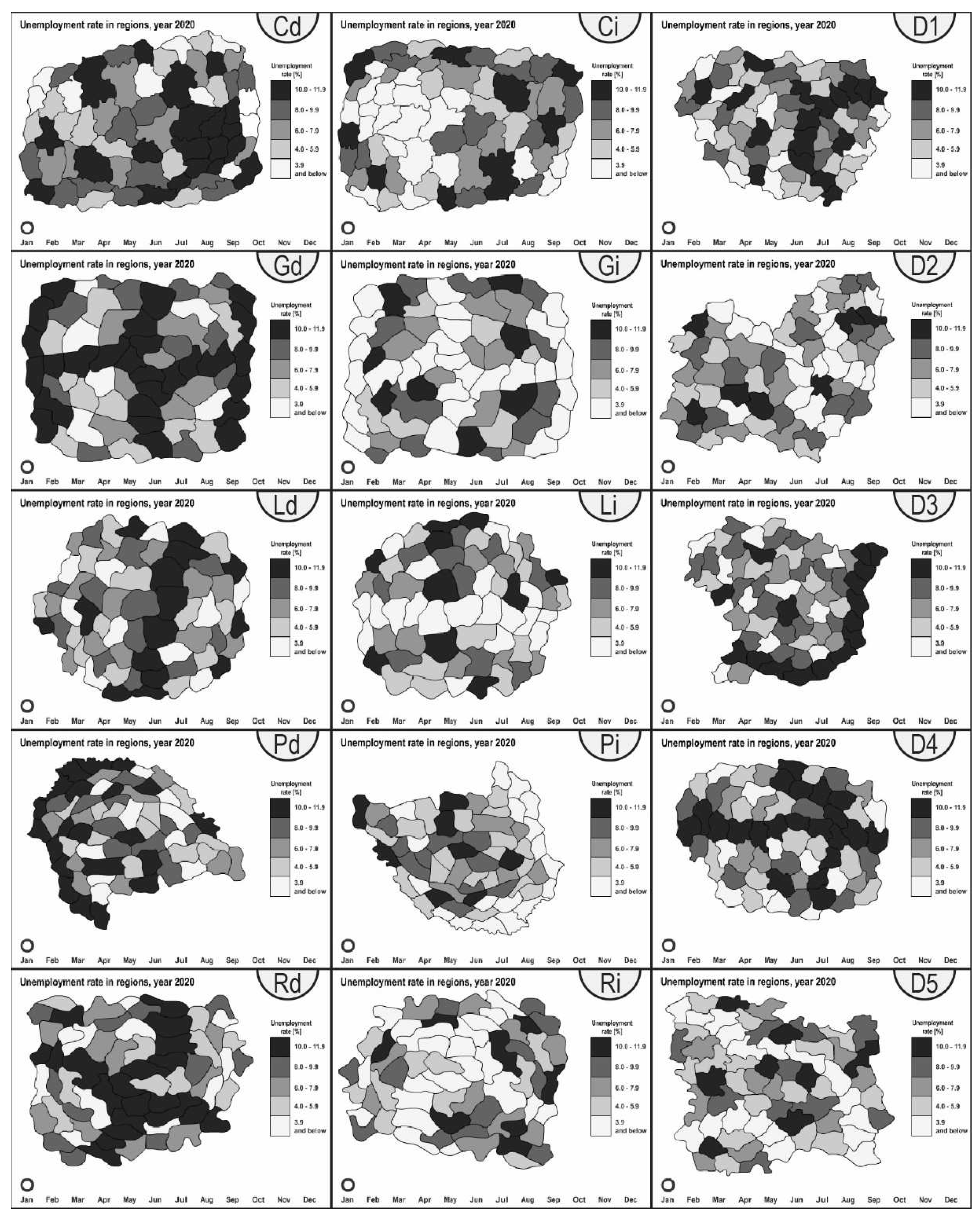
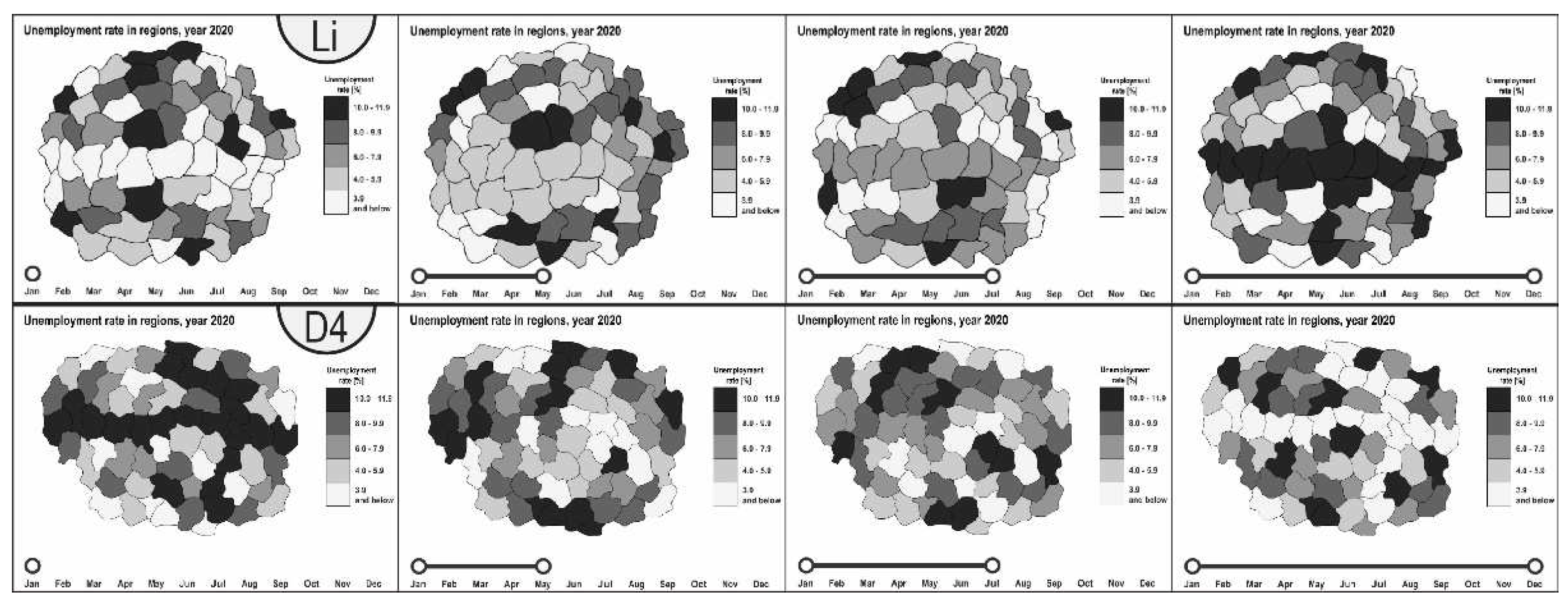
3.3. Materials
3.4. Procedure
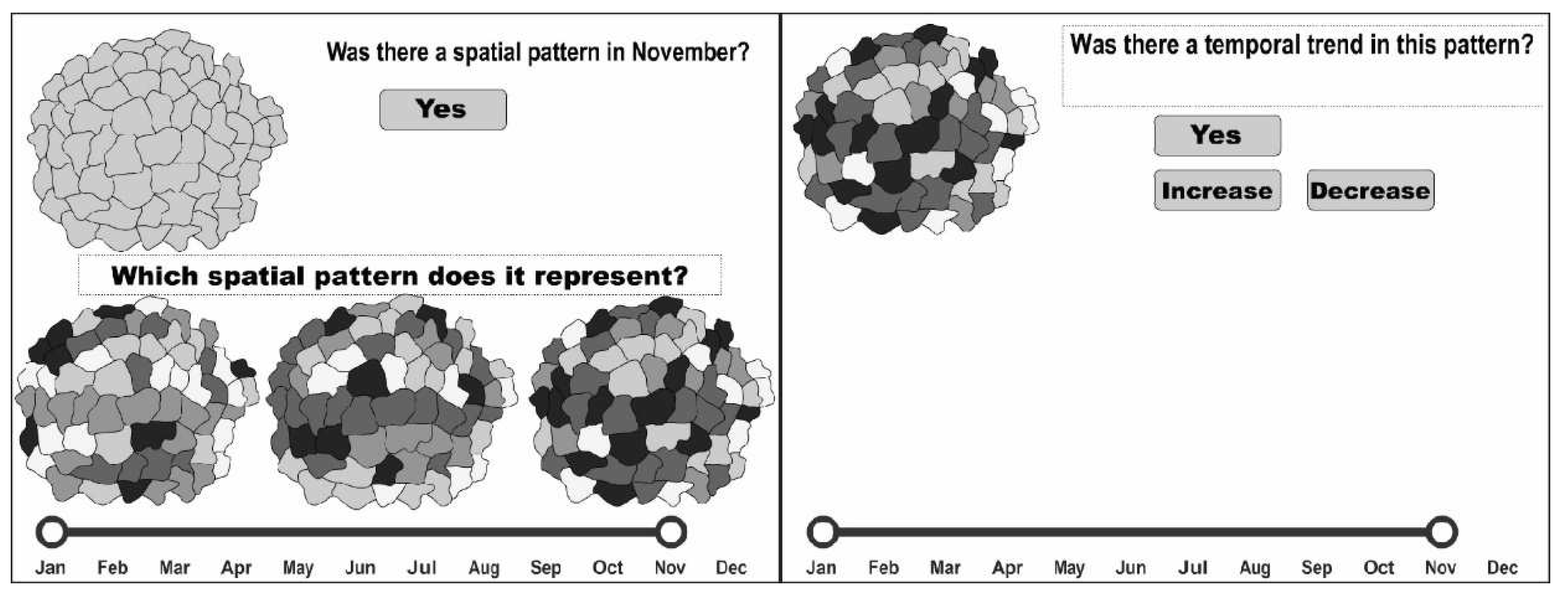
- Was there a spatial pattern in (random month except for January and December)? (Possible answers: Yes or No).
- Which spatial pattern does it represent? (One of three maps to choose from; only one was correct).
- Was there a temporal trend in this pattern? (Possible answers: Yes or No; if Yes, then the possible answers were Increase or Decrease)
3.5. Analysis
4. Results
4.1. Spatial Pattern and Temporal Trend Recognition Effectiveness
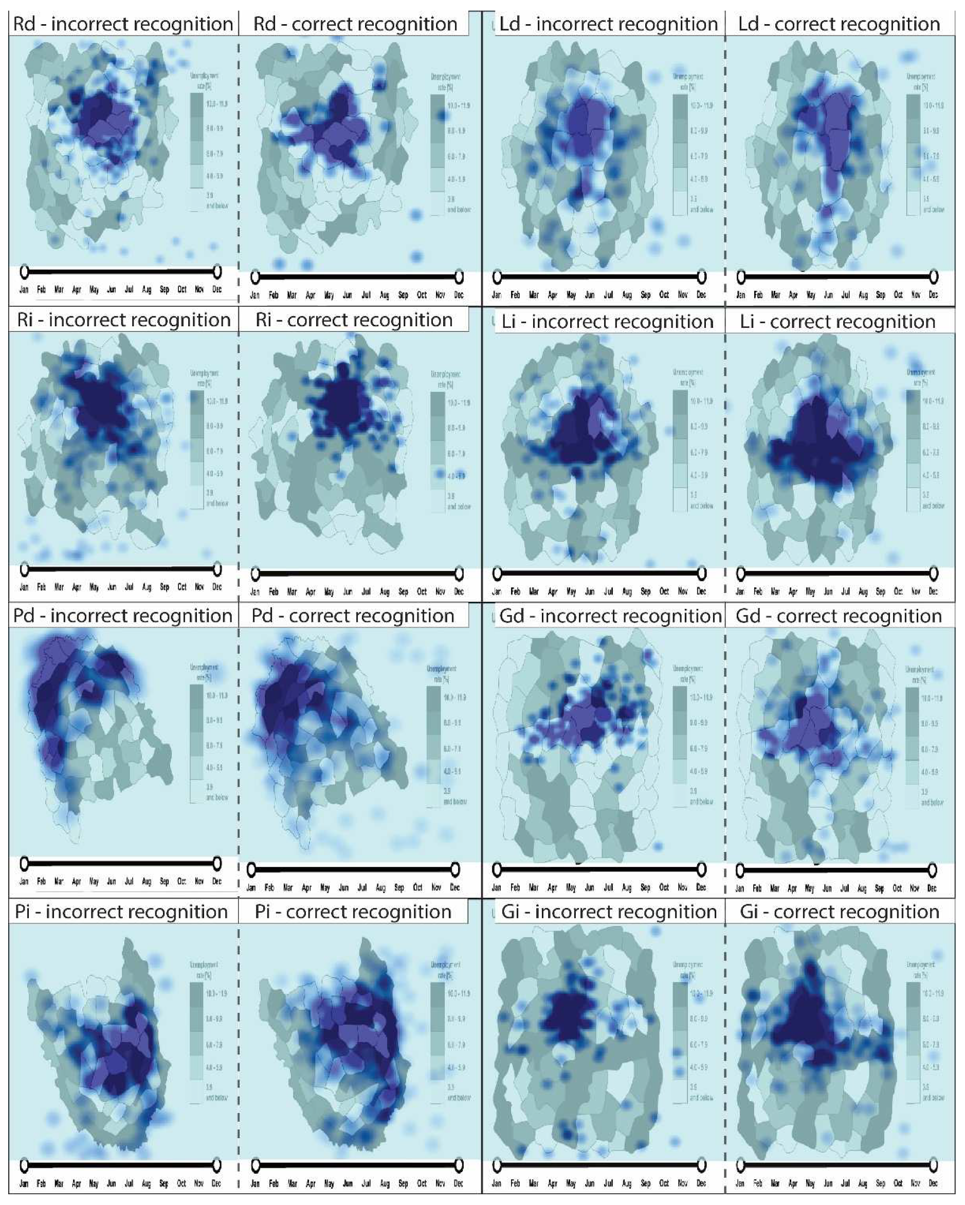
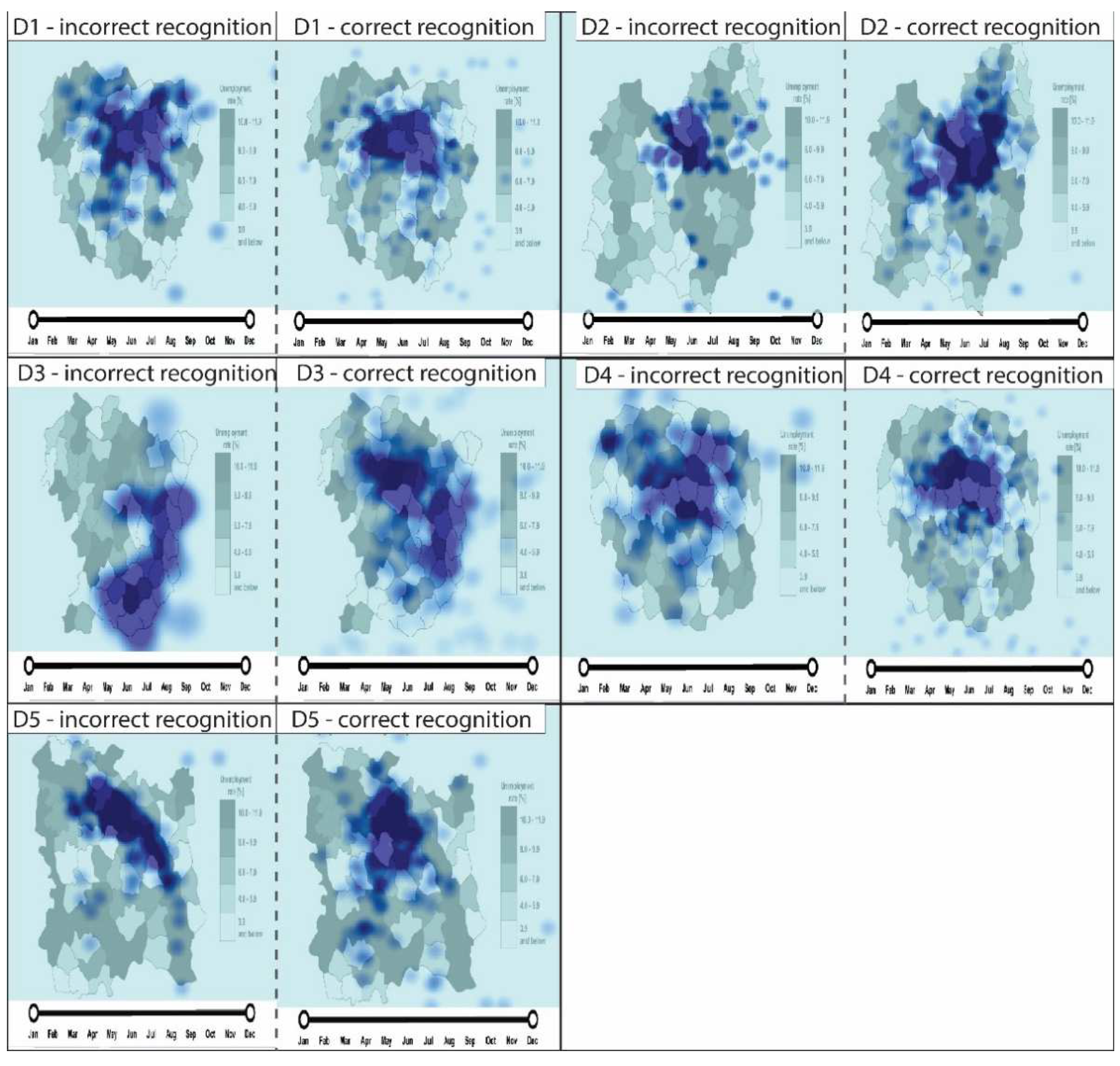
4.2. Participants’ Visual Behavior
5. Discussion
6. Conclusions
Funding
Data Availability Statement
Acknowledgments
Conflicts of Interest
References
- Gartner, G.; Bennet, D.A.; Morita, T. Towards ubiquitous Cartography. Cartogr. Geogr. Inf. Sc. 2007, 34, 247–257. [Google Scholar] [CrossRef] [Green Version]
- Edler, D.; Dickmann, F. The Impact of 1980s and 1990s Video Games on Multimedia Cartography. Cartographica 2017, 52, 168–177. [Google Scholar] [CrossRef]
- Medyńska-Gulij, B.; Forrest, D.; Cybulski, P. Modern Cartographic Forms of Expression: The Renaissance of Multimedia Cartography. ISPRS Int. J. Geoinf. 2021, 10, 484. [Google Scholar] [CrossRef]
- Roth, R.E. Interactive maps: What we know and what we need to know. J. Spat. Inf. Sci. 2013, 6, 59–115. [Google Scholar] [CrossRef]
- Roth, R.E.; Donohue, R.G.; Sack, C.M.; Wallace, T.R.; Buckingham, T.M.A. A Process for Keeping Pace with Evolving Web Mapping Technologies. Cartogr. Perspect. 2014, 78, 25–52. [Google Scholar] [CrossRef] [Green Version]
- Sack, C.M.; Donohue, R.G.; Roth, R.E. Interactive and Multivariate Choropleth Maps with D3. Cartogr. Perspect. 2014, 78, 57–78. [Google Scholar] [CrossRef]
- Horbiński, T.; Cybulski, P.; Medyńska-Gulij, B. Web Map Effectiveness in the Responsive Context of the Graphical User Interface. ISPRS Int. J. Geoinf. 2021, 10, 134. [Google Scholar] [CrossRef]
- Medyńska-Gulij, B. Cartography and Geomedia; Wydawnictwo Naukowe PWN: Warsaw, Poland, 2021; p. 12. [Google Scholar]
- Medyńska-Gulij, B.; Halik, Ł.; Wielebski, Ł.; Dickmann, F. Multiperspective visualization of spatial spare time activities—A smartphone-based approach to mapping tourist routes. KN-J. Cartogr. Geogr. 2015, 65, 323–329. [Google Scholar]
- Halik, Ł.; Kent, A.J. Measuring user preferences and behaviour in a topographic immersive virtual environment (TopoIVE) of 2D and 3D urban topographic data. Int. J. Digit. Earth 2021, 14, 1835–1867. [Google Scholar] [CrossRef]
- Medyńska-Gulij, B.; Tegeler, T.; Bauer, H.; Zagata, K.; Wielebski, Ł. Filming the Historical Geography: Story from the Realm of Maps in Regensburg. ISPRS Int. J. Geoinf. 2021, 10, 764. [Google Scholar] [CrossRef]
- Horbiński, T.; Zagata, K. Interpretation of Map Symbols in the Context of Gamers’ Age and Experience. ISPRS Int. J. Geoinf. 2022, 12, 150. [Google Scholar] [CrossRef]
- Harrower, M. A look at the history and future of animated maps. Cartographica 2004, 39, 33–43. [Google Scholar] [CrossRef]
- Harrower, M. The Cognitive Limits of Animated Maps. Cartographica 2007, 42, 349–357. [Google Scholar] [CrossRef]
- Fish, C. Cartographic Challenges in Animated Mapping. In Proceedings of the ICA Workshop on Envisioning the Future of Cartographic Research, Curitiba, Brazil, 21 August 2015. [Google Scholar]
- Andrienko, G.; Andrienko, N.; Demsar, U.; Dransch, D.; Dykes, J.; Fabrikant, S.I.; Jern, M.; Kraak, M.-J.; Schumann, H.; Tominski, C. Space, time and visual analytics. Int. J. Geogr. Inf. Sci. 2010, 24, 1577–1600. [Google Scholar] [CrossRef] [Green Version]
- Hegarty, M.; Kriz, S.; Cate, C. The roles of mental animations and external animations in understanding mechanical systems. Cogn. Instr. 2003, 21, 325–360. [Google Scholar] [CrossRef]
- Lee, P.U.; Klippel, A.; Tappe, H. The effect of motion in graphical user interfaces. In Smart Graphics: Lecture Notes in Computer Science; Butz, A., Krüger, A., Olivier, P., Eds.; Springer: Berlin/Heidelberg, Germany, 2003; Volume 2733, pp. 12–21. [Google Scholar]
- Juergens, C. Trustworthy COVID-19 Mapping: Geo-Spatial Data Literacy Aspects of Choropleth Maps. KN-J. Cartogr. Geogr. 2020, 70, 155–161. [Google Scholar] [CrossRef] [PubMed]
- von Wyss, M. The production of smooth scale changes in an animated map project. Cartogr. Perspect. 1996, 23, 12–20. [Google Scholar] [CrossRef]
- Battersby, S.E.; Goldsberry, K.P. Considerations in Design of Transition Behaviors for Dynamic Thematic Maps. Cartogr. Perspect. 2010, 65, 16–32. [Google Scholar] [CrossRef]
- Roth, R.E. Cartographic Design as Visual Storytelling: Synthesis and Review of Map-Based Narratives, Genres, and Tropes. Cartogr. J. 2021, 58, 83–114. [Google Scholar] [CrossRef]
- Harrower, M. Tips for Designing Effective Animated Maps. Cartogr. Perspect. 2003, 44, 63–65. [Google Scholar] [CrossRef]
- Lloyd, R.E. Attention on Maps. Cartogr. Perspect. 2005, 52, 28–57. [Google Scholar] [CrossRef]
- Robinson, A.C. Highlighting in Geovisualization. Cartogr. Geogr. Inf. Sci. 2013, 38, 373–383. [Google Scholar] [CrossRef]
- Maggi, S.; Fabrikant, S.I.; Imbert, J.-P.; Hurter, C. How Do Display Design and User Characteristics Matters in Animation? An Empirical Study with Air Traffic Control Displays. Cartographica 2016, 51, 25–37. [Google Scholar] [CrossRef]
- Goldsberry, K.P.; Battersby, S.E. Issues of Change Detection in Animated Choropleth Maps. Cartographica 2009, 44, 201–215. [Google Scholar] [CrossRef] [Green Version]
- Fish, C.; Goldsberry, K.P.; Battersby, S.E. Change Blindness in Animated Choropleth Maps: An Empirical Study. Cartogr. Geogr. Inf. Sci. 2011, 38, 250–362. [Google Scholar] [CrossRef]
- Moon, S.; Kim, E.-K.; Hwang, C.-S. Effects of Spatial Distribution on Change Detection in Animated Choropleth Maps. J. Korean Soc. Surv. Geod. Photogramm. Cartogr. 2014, 32, 571–580. [Google Scholar] [CrossRef]
- Cybulski, P.; Medyńska-Gulij, B. Cartographic Redundancy in Reducing Change Blindness in Detecting Extreme Values in Spatio-Temporal Maps. ISPRS Int. J. Geoinf. 2018, 7, 8. [Google Scholar] [CrossRef] [Green Version]
- Fisher, B.; Ramsperger, E. Human express saccades: Extremely short reaction times of goal directed eye movements. Exp. Brain Res. 1984, 57, 191–195. [Google Scholar] [CrossRef] [PubMed]
- Lisberger, S.G. Visual guidance of smooth pursuit eye movements: Sensation, action, and what happens in between. Neuron 2010, 66, 477–491. [Google Scholar] [CrossRef] [Green Version]
- Cybulski, P. Effectiveness of Memorizing an Animated Route—Comparing Satellite and Road Map Differences in the Eye-Tracking Study. ISPRS Int. J. Geoinf. 2021, 10, 159. [Google Scholar] [CrossRef]
- Harrower, M. Unclassed Animated Choropleth Maps. Cartogr. J. 2007, 44, 313–320. [Google Scholar] [CrossRef]
- Just, M.A.; Carpenter, P.A. Eye Fixations and Cognitive Processes. Cogn. Psychol. 1967, 8, 441–480. [Google Scholar] [CrossRef]
- Rayner, K. Eye Movements and Attention in Reading, Scene Perception, and Visual Search. Q. J. Exp. Psychol. 2009, 62, 1457–1506. [Google Scholar] [CrossRef] [PubMed]
- Edler, D.; Keil, J.; Tuller, M.-C.; Bestgen, A.-K.; Dickmann, F. Searching for the ‘Right’ Legend: The Impact of Legend Position on Legend Decoding in a Cartographic Memory Task. Cartogr. J. 2020, 57, 6–17. [Google Scholar] [CrossRef]
- Andrienko, N.; Andrienko, G.; Gatalsky, P. Exploratory spatio-temporal visualization: An analytical review. J. Vis. Lang. Comput. 2003, 14, 503–541. [Google Scholar] [CrossRef]
- DiBiase, D.; MacEachren, A.M.; Krygier, J.B.; Reeves, C. Animation and the role of map design in scientific visualization. Cartogr. Geogr. Inf. Sys. 1992, 19, 201–214. [Google Scholar] [CrossRef]
- Blok, C. Monitoring change: Characteristics of dynamic geo-spatial phenomena for visual exploration. In Spatial Cognition II, Lecture Notes on Artificial Intelligence; Freska, C., Habel, C., Brauer, W., Wender, K.F., Eds.; Springer: Berlin/Heidelberg, Germany, 2000; Volume 1849, pp. 16–30. [Google Scholar]
- Peuquet, D.J. It’s about time: A conceptual framework for the representation of temporal dynamics in geographic information systems. Ann. Am. Assoc. Geogr. 1994, 84, 441–461. [Google Scholar] [CrossRef]
- Li, D.; Samet, H.; Varshney, A. Visualizing accessibility with choropleth maps. In Proceedings of the 5th ACM SIGSPATIAL International Workshop on Location-based Recommendations, Geosocial Networks and Geoadvertising, Bejijng, China, 2 November 2021. [Google Scholar]
- Bertin, J. Semiology of Graphics Diagrams Networks Maps; The University of Wisconsin Press: Madison, WI, USA, 1986. [Google Scholar]
- Medyńska-Gulij, B. The effect of cartographic content on tourist map users. Cartography 2003, 32, 49–54. [Google Scholar] [CrossRef]
- Schroeder, J.P. Trends in patterns versus patterns in trends: A key distinction for visualizing geographic time-series data. In Proceedings of the 23rd International Cartographic Conference, Moskov, Russia, 4–10 August 2007. [Google Scholar]
- Borregaard, M.K.; Hendrichsen, D.; Nachman, G. Spatial distribution patterns. In Encyclopedia of Ecology, 2nd ed.; Jørgensen, S.E., Fath, B.D., Eds.; Elsevier: Oxford, UK, 2009; pp. 3303–3310. [Google Scholar]
- Ripley, B.D. Modelling Spatial Patterns. J. R. Stat. Soc. Ser. B Stat. Methodol. 1977, 39, 172–192. [Google Scholar] [CrossRef]
- Anders, A.M.; Roe, G.H.; Hallet, B.; Montgomery, D.R.; Finnegan, N.J.; Putkonen, J. Spatial patterns of precipitation and topography in the Himalaya. In Tectonics, Climate, and Landscape Evolution; Willett, S.D., Hovius, N., Brandon, M.T., Fisher, D.M., Eds.; The Geological Society of America: Colorado, CO, USA, 2006; pp. 39–53. [Google Scholar]
- Sapiro, P. Explaining geographic patterns of small group internal migration. Popul. Space Place 2017, 23, e0278. [Google Scholar] [CrossRef]
- Sinnott-Armstrong, M.; Downie, A.E.; Federman, S.; Valido, A.; Jordano, P.; Donoghue, M.I. Global geographic patterns in the colours and sizes of animal-dispersed fruits. Glob. Ecol. Biogeogr. 2018, 27, 1339–1351. [Google Scholar] [CrossRef]
- Kraak, M.-J.; MacEachren, A.M. Visualization of spatial data’s temporal component. In Proceedings of the Spatial Data Handling, Advances in GIS Research, Edinburgh, Scotland, UK, 5–9 September 1994. [Google Scholar]
- Guo, D.; Chen, J.; MacEachren, A.M.; Liao, K. A Visualization System for Space-Time and Multivariate Patterns. IEEE Trans. Vis. Comput. Graph. 2006, 12, 1461–1474. [Google Scholar] [PubMed] [Green Version]
- Blok, C.; Köbben, B.; Cheng, T.; Kuterema, A.A. Visualization of Relationship Between Spatial Patterns in Time by Cartographic Animation. Cartogr. Geogr. Inf. Sci. 1999, 26, 139–151. [Google Scholar] [CrossRef]
- Edsall, R.M.; Harrower, M.; Mennis, J.L. Tools for visualizing properties of spatial and temporal periodicity in geographic data. Comput. Geosci. 2000, 26, 109–118. [Google Scholar] [CrossRef] [Green Version]
- Griffin, A.L.; MacEachren, A.M.; Hardisty, F.; Steiner, E.; Li, B. A Comparison of Animated Maps with Static Small-Multiple Maps for Visually Identifying Space-Time Clusters. Ann. Am. Assoc. Geogr. 2006, 96, 740–753. [Google Scholar] [CrossRef] [Green Version]
- Schiewe, J. Empirical Studies on the Visual Perception of Spatial Patterns in Choropleth Maps. KN-J. Cartogr. Geogr. 2019, 69, 217–228. [Google Scholar] [CrossRef] [Green Version]
- Karsznia, I.; Gołębiowska, I.M.; Korycka-Skorupa, J.; Nowacki, T. Searching for an Optimal Hexagonal Shaped Enumeration Unit Size for Effective Spatial Pattern Recognition in Choropleth Maps. ISPRS Int. J. Geoinf. 2021, 10, 576. [Google Scholar] [CrossRef]
- Traun, C.; Schreyer, M.L.; Wallentin, G. Empirical Insight from a Study on Outlier Preserving Value Generalization in Animated Choropleth Maps. ISPRS Int. J. Geoinf. 2021, 10, 208. [Google Scholar] [CrossRef]
- Cinnamon, J.; Rinner, C.; Cusimano, M.D.; Marshall, S.; Bekele, T.; Hernandez, T.; Glazier, R.H.; Chipman, M.L. Evaluating web-based static, animated and interactive maps for injury prevention. Geospat. Health 2009, 4, 3–16. [Google Scholar] [CrossRef] [Green Version]
- Koussoulakou, A.; Kraak, M.-J. Spatio-temporal maps and cartographic communication. Cartogr. J. 1992, 29, 101–108. [Google Scholar] [CrossRef]
- Monmonier, M. Mapping It Out: Expository Cartography for the Humanities and Social Sciences; University of Chicago Press: Chicago, IL, USA, 2015; p. 12. [Google Scholar]
- Dong, W.; Zheng, L.; Liu, B.; Meng, L. Using Eye Tracking to Explore Differences in Map-Based Spatial Ability between Geographers and Non-Geographers. ISPRS Int. J. Geoinf. 2018, 7, 337. [Google Scholar] [CrossRef] [Green Version]
- Dong, W.; Liao, H.; Xu, F.; Liu, Z.; Zhang, S. Using Eye Tracking to Evaluate the Usability of Animated Maps. Sci. China Earth Sci. 2014, 57, 512–522. [Google Scholar] [CrossRef]
- Cybulski, P.; Krassanakis, V. The Role of Magnitude of Change in Detecting Fixed Enumeration Units on Dynamic Choropleth Maps. Cartogr. J. 2021, 1–17. [Google Scholar] [CrossRef]
- Rensink, R.A. Change Detection. Annu. Rev. Psychol. 2002, 53, 245–277. [Google Scholar] [CrossRef] [PubMed]


| Average Nearest Neighbor Summary | ||||||||||
|---|---|---|---|---|---|---|---|---|---|---|
| Incorrect Recognition | Correct Recognition | |||||||||
| OMD | EMD | NNI | z | p | OMD | EMD | NNI | z | p | |
| D1 | 0.0235 | 0.0299 | 0.785 | −4.460 | <0.0000 | 0,0099 | 0.0167 | 0,593 | −16.922 | <0.0000 |
| D2 | 0.0148 | 0.0223 | 0.663 | −7.327 | <0.0000 | 0.0103 | 0.0159 | 0.652 | −13.643 | <0.0000 |
| D3 | 0.0267 | 0.0285 | 0.936 | −0.794 | 0.4272 | 0.0112 | 0.0168 | 0.667 | −13.192 | <0.0000 |
| D4 | 0.0254 | 0.0292 | 0.871 | −2.722 | 0.0065 | 0.0086 | 0.0136 | 0.637 | −17.654 | <0.0000 |
| D5 | 0.0153 | 0.0237 | 0.646 | −8.800 | <0.0000 | 0.0157 | 0.0219 | 0.716 | −8.255 | <0.0000 |
| Pd | 0.0195 | 0.0309 | 0.630 | −7.148 | <0.0000 | 0.0121 | 0.0173 | 0.702 | −11.623 | <0.0000 |
| Pi | 0.0158 | 0.0202 | 0.782 | −5.799 | <0.0000 | 0.0112 | 0.0140 | 0.796 | −8.267 | <0.0000 |
| Gd | 0.0114 | 0.0176 | 0.647 | −9.854 | <0.0000 | 0.0126 | 0.0173 | 0.727 | −9.382 | <0.0000 |
| Gi | 0.0167 | 0.0251 | 0.664 | −8.596 | <0.0000 | 0.0137 | 0.0186 | 0.737 | −8.942 | <0.0000 |
| Ld | 0.0145 | 0.0196 | 0.741 | −6.947 | <0.0000 | 0.0136 | 0.0189 | 0.720 | −7.926 | <0.0000 |
| Li | 0.0114 | 0.0168 | 0.678 | −11.092 | <0.0000 | 0.0140 | 0.0230 | 0.609 | −12.306 | <0.0000 |
| Cd | 0.0149 | 0.0214 | 0.696 | −8.868 | <0.0000 | 0.0166 | 0.0232 | 0.713 | −7.757 | <0.0000 |
| Ci | 0.0196 | 0.0287 | 0.682 | −7.423 | <0.0000 | 0.0099 | 0.0154 | 0.640 | −16.880 | <0.0000 |
| Rd | 0.0104 | 0.0158 | 0.662 | −13.700 | <0.0000 | 0.0173 | 0.0265 | 0.655 | −7.640 | <0.0000 |
| Ri | 0.0113 | 0.0159 | 0.710 | −11.433 | <0.0000 | 0.0142 | 0.0211 | 0.675 | −8.584 | <0.0000 |
Publisher’s Note: MDPI stays neutral with regard to jurisdictional claims in published maps and institutional affiliations. |
© 2022 by the author. Licensee MDPI, Basel, Switzerland. This article is an open access article distributed under the terms and conditions of the Creative Commons Attribution (CC BY) license (https://creativecommons.org/licenses/by/4.0/).
Share and Cite
Cybulski, P. An Empirical Study on the Effects of Temporal Trends in Spatial Patterns on Animated Choropleth Maps. ISPRS Int. J. Geo-Inf. 2022, 11, 273. https://doi.org/10.3390/ijgi11050273
Cybulski P. An Empirical Study on the Effects of Temporal Trends in Spatial Patterns on Animated Choropleth Maps. ISPRS International Journal of Geo-Information. 2022; 11(5):273. https://doi.org/10.3390/ijgi11050273
Chicago/Turabian StyleCybulski, Paweł. 2022. "An Empirical Study on the Effects of Temporal Trends in Spatial Patterns on Animated Choropleth Maps" ISPRS International Journal of Geo-Information 11, no. 5: 273. https://doi.org/10.3390/ijgi11050273
APA StyleCybulski, P. (2022). An Empirical Study on the Effects of Temporal Trends in Spatial Patterns on Animated Choropleth Maps. ISPRS International Journal of Geo-Information, 11(5), 273. https://doi.org/10.3390/ijgi11050273