Article

Metric, Topological, and Syntactic Accessibility in Three-Dimensional Urban Networked Spaces: Modeling Options and Visualization

by
Thi Hong Diep Dao
1 and
Jean-Claude Thill
2,*
1
Department of Geography and Environmental Studies, University of Colorado-Colorado Springs, Colorado Springs, CO 80920, USA
2
Department of Geography and Earth Sciences and School of Data Science, University of North Carolina at Charlotte, Charlotte, NC 28223, USA
*
Author to whom correspondence should be addressed.
ISPRS Int. J. Geo-Inf. 2022, 11(9), 467; https://doi.org/10.3390/ijgi11090467
Submission received: 20 June 2022 / Revised: 21 August 2022 / Accepted: 25 August 2022 / Published: 29 August 2022

Abstract

:
In this paper, we take the position that cities gain to be represented as three-dimensional spaces populated by scores of micro-scale-built spaces (buildings, rooms, passageways, squares, etc.). Effective algorithms that evaluate place-based accessibility in built structures while considering the indoor spaces’ complexity at a fine granularity are essential for indoor–outdoor seamless urban planning, navigation, way findings, and supporting emergencies. We present a comprehensive set of spatial modeling options and visualizations of indoor accessibility for an entire built structure based on various notions of travel impedance. Notably, we consider the metric length of the paths and their cognitive complexities due to topologic, syntactic, or integrated intricacy within our approaches. Our work presents a comprehensive selection of indoor accessibility analysis with a detailed implemental discussion that can be applied as a solid foundation for smart city applications or seamless urban research and planning. The analysis and visualization techniques presented in this paper can be easily applied to analyze and visualize built interior geographic spaces to study accessibility differentials in cities with vast vertical expansion aimed at achieving (or at avoiding) specific accessibility outcomes.

1. Introduction

With over half of the world’s population being urbanized, cities worldwide, especially the large and fast-growing ones, are experiencing more land-use intensification and population densification through vertical development and complex three-dimensional topological layout. Multi-use buildings are the norm rather than the exception, which presents a compelling setting for extending concepts and analytic techniques of urban and transportation geography [1,2]. In particular, the concept of accessibility, developed originally for the two-dimensional, horizontal space, can be extended to the vertical dimension and ultimately to the three-dimensional city as a whole.
The notion of place-based accessibility is commonly understood to encapsulate the ease with which activities a person at a particular location can reach other locations via some mode(s) of travel and engage there in certain activities [3,4,5,6]. It has played a central role in outdoor urban and regional planning for several decades. As cities expand vertically, comprehensive evaluations of accessibility for an urban environment or built structure are essential to understanding the spatial and functional relationships among indoor interior spaces and the ease of reach and use of spaces with the broader spatial context; thus, it is useful towards the goal of improving urban and space planning in support of smart city applications. However, evaluating the accessibility for an entire indoor built structure is challenging. Lacking readily available indoor traversable network data and the associated high cost of generating such is one of the reasons. In addition, the complex three-dimensional topological layout of buildings imposes distinct syntactic and cognitive impedances to indoor travelers [7,8]. Thus, how to capture and represent the indoor traversable network that reflects travelers’ space cognition is not straightforward [9,10]. Also, the traditional accessibility modeling framework that applies impedances based on the shortest travel distances used in outdoor space evaluation needs to be extended [11,12]. Although metric impedance is still important, it is no longer the only recognized barrier to the mobility between places and to their connectivity, especially indoors where the field of vision may be obstructed by the indoor topologies and partitions that define enclosed spaces [11,13].
In this paper, we take the position that cities gain to be represented as three-dimensional spaces populated by scores of micro-scale built spaces (buildings, rooms, passageways, squares, and so on) [14]. Spatial and functional relationships between these spaces, as framed by the indoor and outdoor infrastructure supporting human movements (hallways, elevator shafts, walkways, and others), are what make the environments of human beings relevant to their daily lives. The development of practical algorithms and comprehensive visual examination of accessibility is essential to indoor spatial analysis, which becomes crucial in indoor structure auditing, space planning and design, navigation and wayfinding, and indoor facility placements [15]. This body of methodologies is also vital to research accessibility disparities in cities with vast vertical expansion to achieve (or avoid) specific accessibility outcomes.
Expounding on pilot work done by the authors in [16], we present here a comprehensive set of spatial modeling options for indoor accessibility and their associated visualization forms for an entire built structure. Our framework first constructs an analytical model of a given indoor traversable network that is not only based on metric measures (i.e., distances), but also on notions of topology (i.e., connectivity) and spatial syntax (i.e., angular visibility). The accessibility of the entire structure is then computed and visualized based on a range of modeling options, which are either metric, topological, syntactic, or their integration. Our work presents a comprehensive set of indoor accessibility analysis tools that can be applied as a foundation for smart city applications or seamless urban planning and analysis.
This paper is comprised of four sections, in addition to the final concluding section. The first section presents essential concepts to process given indoor 3D transportation network data for accessibility evaluation. This includes the elaboration of various possible types of impedances associated with changes in direction (horizontally and vertically) in movement within a built structure. The following section uses these concepts to propose several accessibility modeling approaches for indoor environments. Next, in the third session, the implementation process is discussed. Finally, a case study with results is presented in the fourth section.

2. Related Works

Within the framework of the research paradigm of the Digital City (e.g., [17]) and the Smart City (e.g., [18]), three research streams can be related to this work: (1) indoor travel behaviors, (2) indoor travel network data models, and (3) state-of-the-art indoor navigation and accessibility modeling approaches. However, given the significant amount of published works, only selective references are presented and discussed here.
Research on pedestrian indoor travel behavior is rich, requires a multi-domain approach [19], and helps significantly in understanding how pedestrians perceive and navigate the indoor environment. Unlike outdoor environments, indoors are closed spaces made available to users; these spaces have a particular building spatial structure design characterized by multilevel interior subspaces connected by corridors and vertical transitions. The indoor environment, thus, is more compressed, with a much shorter field of view compared to the outdoor environment [7,8]. Ref. [20] suggested three essential factors for integration to understand indoor navigation behavior fully. These include the spatial structure of a building, the cognitive maps that users construct as they navigate it, and the strategies and spatial abilities of the building’s users. Notably, a three-dimensional environment architecture can imply different visual experiences [21], thus imposing distinct syntactic and cognitive impedances to indoor travelers [7,8,22].
From a modeling perspective, Hillier’s concept of space syntax [23,24] is valuable for constructing a framework for spatial cognition that relates to human understanding and perception of geographic space. Space syntax describes space through relative visual connectivity and angular path complexity [25,26,27] to generate an axial map of the built environment. The concept of spatial syntax has been adopted in several studies to understand and model human cognitive perception but is limited to urban open spaces [9,10,28,29,30,31,32,33]. Recent efforts endeavored to extend the concept of three-dimensional topographical urban space (e.g., [34,35]) but stopped short when encountering the indoor complexity.
Constructing a framework for modeling movement paths and assessing indoor accessibility that can be applied to a wide range of building structure designs and different travelers is indeed very challenging. It requires an indoor transportation network representation of traversable spaces through the built-up space to support routing analysis. This network is often constructed with spatial vector data (i.e., points, lines, polygons) to represent segments of the traversable paths and their connectivity. The network often serves as a simplified version of the actual indoor traversable space to leverage the complex spatial structure of buildings. To effectively model indoor travel behavior, it should also reflect the cognitive maps of the traversable space users construct and prefer to use as they navigate.
Literature shows various research efforts to effectively model and produce the indoor transportation network; 2.5-dimensional (2.5D) and 3-dimensional (3D) centerline data models are the most popular. The 2.5-D corridor centerline model [36], explained in the next section, conceptualizes a building as a stack of separate compartments representing each floor. These compartments are distinguished vertically using a height separation and are connected through a vertical transition access system such as stairways and elevators. The 3D data model [34,37,38] (is an extension of the 2.5D model, where the real elevation data of each floor is used, which helps to integrate a better analysis of a building with the larger indoor–outdoor seamless environment. The corridor centerline data model can be further enhanced to better capture travelers’ cognitive components. For example, axial lines, the longest straight line representing the maximum extension of a point of space, have been used instead of corridor centerlines to construct the network [26,39]. Also, ref. [13] recently suggested using seamless indoor and outdoor volumetrics centerlines, after testing empirically various spatial models of a complex indoor and outdoor urban setting. The transportation network can also be extended to include additional attributes of the traversable paths as barriers to support routing analysis for different user groups, particularly those with access impairments. Among the proposed data model, the 2.5-D corridor and its enhanced versions have been proven effective in studying accessibility at a very fine spatial resolution for indoor spaces [16]. This data model is also cost-effective to generate by integrating the building information modeling (BIM) data model and digital CAD floor plans—which are popular and often available for developed urban areas [40].
With the development in indoor spatial behavior theories and the capability to construct effective indoor transportation networks, great effort has been directed towards developing algorithms to detect potential paths for navigation and way findings. Routing algorithm research has evolved from using Euclidean shortest path routing to suggesting a diverse set of route choice cognitive preferences, including least turn [41] or least angular [10,42]. These studies, however, have mainly focused on estimating the indoor travel impedance for any given origin–destination pair, which could then be used for smart city applications on mobile devices. In these studies, various criteria for travel impedance were considered, e.g., network shortest distances, grid-based traversable shortest distances, obstacle-free traversable shortest distances, or distances with the fewest turns for different groups of users under different circumstances [43,44]. However, the resulting travel paths were not comprehensively evaluated and compared across the entire built structure.
Presently, evaluating the overall accessibility of a built-up section of the urban fabric considering a range of alternative modeling options with informative visualization platforms is restricted by the dearth of research in this area, which points to a gap in the literature. Ref. [45] broached the subject of accessibility inside a building but stopped short of presenting a model, visualization strategy, and implementation aspects that would support their discussion. Ref. [46] introduced a simple integration of metric distance and space syntax depth measures for accessibility analysis within a building, but this approach did not explicitly consider the complex nature of network turns. It rather arbitrarily assigns constant impedance for each type of turn: turning left, turning right, and vertical turns. Ref. [47] applied space syntax with users’ feedback to assess the floor plan topologies of an elementary school building. This study, however, considered only the disintegrated individual floor and sidestepped the complexity of small space subdivisions like rooms and staircases. Exceptionally, there exists a couple of studies that involve indoor accessibility evaluation and provide a comprehensive software prototype for enhancing building design and applications [16,48]. While ref. [16] serve as the foundation of this work, it considered only a limited single evaluation model of accessibility using the metric shortest-distance criterion. Ref. [48] present a wide range of three-dimensional network analysis functions with a number of modeling approaches based on metric shortest-distance, spatial syntax, angular, and hybrid criteria. However, this work focused more on creating software and tool-based analysis functionalities to support network analysis rather than a comprehensive analysis and comparison among different accessibility modeling possibilities. Additionally, this work is applied to the much larger scale of an urban 3D space at large, rather than focusing on the detailed and fine-grain complexities within an indoor space. Given the emphasis of these authors’ work on demonstrating the spatial functional relationship of the indoor space for architectural design, planning, and spatial location analysis, they stop short of presenting a detailed analysis of indoor accessibility with their modeling approach.
This study contributes to the literature a comprehensive set of six spatial modeling options for indoor accessibility and their associated visualization forms for an entire built structure. A flexible (for enhancement) indoor network data model coupled with generalized accessibility modeling approaches and effective 3D visualization technique make this work distinctive to provide a solid foundation for developing indoor accessibility analysis toolsets and their applications.

3. Indoor Transportation Network Data Modeling

3.1. Indoor Transportation Network

We use herein an object-oriented 2.5-D data modeling approach proposed by [36], according to which a multilevel building is conceptualized as a stack of separate compartments representing each floor of the building. In the case of the implementation presented later in the article, the network was generated manually by digitizing the floor plans of the featured building to ensure accuracy. The concepts and algorithms to process network data and estimate accessibility presented in this work can be applied to different indoor traversable networks, if desired.
Each floor compartment is sub-divided into room and corridor entities that form the network connecting all of the rooms and entrance/exit points on the floor. Movement between floor compartments is enabled by an access system of staircases and elevators; access points represent exterior doors through which movement between indoor and outdoor spaces is enabled. Nodes on the network are used to represent rooms, arc junctions, or access points. Hence the elemental granularity of the model is the room.
Corridors are represented by arcs (such as the medial axis of a polygonal corridor) stored in a line feature class. The access system formed of stairs, elevators, and doors is modeled as node features through which corridor arcs are connected. Thus, the staircase and the elevator locations on each floor can be represented as node features in a node feature class. Effectively, the network of each floor is placed in a separate group, and connectivity between each group is allowed only at defined points corresponding to elevator shafts and stairwells. Consequently, 3D connectivity required to represent a traversable indoor network is achieved, and the indoor network created on these principles becomes fully routable once proper impedances are assigned to all the arcs of the network [14,36].

3.2. Strokes

In order to assess the syntactic travel impedances and their contribution to place-based accessibility, the indoor travel network is generalized using the concept of strokes. A stroke is defined as a set of one or more arcs in a non-branching, connected chain syntactically generated from indoor corridor central lines as the product of angular analysis [31,49,50,51,52]. Two arcs are considered on the same stroke if the change in travel direction—the angular value θ between them—is less than a certain threshold θS (see Figure 1). No particular value of θS is suggested as suitable in the literature. θS is set to be equal to 30 degrees for the implementation of this study, although other values can be used if supported by empirical evidence. The AxialGen software [52] is used to track strokes on every floor of the indoor transportation network. For example, the long corridor represented by a thick red line in Figure 2a and comprising 27 arcs is resolved into a single stroke represented by a thick blue line in Figure 2b. The generation of strokes allows us to define the indoor transportation network syntactically as a notion stemming from connectivity and visibility.

3.3. Floor Turns

Floor turns are used to represent vertical turn impedance associated with movement between floors. A floor turn starts with the traveler entering a staircase or an elevator and ends with the traveler exiting the staircase or the elevator. Figure 3 shows an example of the floor turn required for a path from Room 101 on floor 1 to Room 200 on floor 2. The impedance of the floor turn can be set to the number of minutes (or fraction thereof) required to travel by elevator or stairs if one is interested in metric impedance; it can be set equal to 1 for syntactic, topological, and angular impedances. The same approach can be used for other forms of devices or technologies enabling movement between flows, such as escalators.

3.4. Syntactic Turns

To account for the syntactic impedance associated with strokes, syntactic turns are created between every two strokes that are topologically incident on the same floor, as demonstrated in Figure 4. Suppose one considers only the syntactic components of a path. Then, travel impedance from any point A to any point B will be the sum of syntactic turn impedances on the path from A to B calculated on the stroke network. The sum of syntactic turns from A to B is also defined as the step depth of B from A in the space syntax literature [25].
In general terms, each syntactic turn can be assigned a specific impedance; this impedance could be a direct function of the angular value. In the implementation of this study, this is simplified by setting the impedance of every syntactic turn to 1.

3.5. Angular Cognitive Turns

Angular turns represent the angular cognitive impedance while traveling through the arc floor network (not the strokes). An angular turn is defined between every two network arcs that are incident at the same node, provided that their angular value (i.e., the change in travel direction) is larger than a certain threshold θ A . This θ A should be differentiated from the threshold θ S used to define the traveling network syntactic stokes. The impedance of a cognitive angular turn between two arcs is a function of the angular value θ between the arcs, if θ   θ A , zero otherwise. It can be expressed as:
Angular   cognitive   turn   impedance = 180 180 θ
There is no particular value of θA suggested as suitable in the literature. The value of θ A is set to 20 degrees for the case study presented in this article. Because the actual angular value between two arcs ranges from 0 to 180 degrees, the value of the angular turn impedance ranges from 1 to infinity in principle. However, because the angular turns are created only if θ is larger than 20 degrees for this study, the value of an angular turn impedance herein ranges from 1.125 to infinity in practice. This means that when a person encounters a turn of 20 or 90 degrees, their cognitive impedance is counted as 1.125 or 2, respectively. If they make a U-turn, the cognitive impedance is infinite. Figure 5 graphically demonstrates the angular turn component.

3.6. Distance-Weighted Angular Cognitive Turns

Distance-weighted angular cognitive turns enhance the measure of angular cognitive turns by adding a weight representing how far one traveled before turning. Intuitively, this weighting allows us to account for the spatial context of the physical turn by the spatial scope of the indoor movement. Like an angular cognitive turn, a distance-weighted angular cognitive turn is created between every two network arcs having angular value (i.e., the change in travel direction) larger than θ A (see Figure 6). The impedance of a cognitive turn between two arcs is a function of the angular θ value between the arcs, if θ   θ A , weighted by the distance d 1 of the arc preceding the turn, and can be formulated as:
Angular   cognitive   turn   impedance = d 1 180 180 θ

3.7. Topological Break Points

Topological breakpoints are created at every breakpoint of the travel network’s connectivity graph, which is detected at junctions of three or more network arcs (as shown in Figure 7). The impedance of each topological turn can be set to a specific value. This value is set to 1 in the implementation presented later in this study. For example, if one considers only the topological component of the path from point A to point B in Figure 7, the impedance is 1.

3.8. Inclusive Transportation Data Modeling

Modeling accessibility for the indoor environment necessitates considerations for inclusiveness. Vulnerable indoor pedestrians include people with mobility, circulatory, respiratory, or neurological impairments who use various kinds of devices for mobility, such as walkers, canes, crutches, braces, manual or power wheelchairs, electric scooters, and Segways [53]. Seniors and individuals with baby strollers also have less access to some indoor spaces because their health conditions and childcare responsibilities limit their travel flexibility and comfort. The baby stroller, in this case, can also be counted as a mobility device. Unlike individuals with impaired mobility, those with vision or cognitive impairment have different challenges navigating the indoor space due to the variable indoor lighting conditions and its complex spatially closed configuration. Hearing-impaired individuals have less access to voice-based navigation guidance if available and thus are limited to text-based or visual-based instructions only.
Inclusive accessibility modeling must thus consider situations when the mobility of the vulnerable population is reduced or restricted by movement barriers that exist in the environment. For example, traversable indoor paths for people with mobility devices must be free of steps and spacious enough for the device to fit comfortably. Additionally, uneven terrain or heavy pedestrian traveling flow can disrupt the accessibility of the vulnerable population. The indoor environments, designed for specific operational functions, also have operating hours with varying occupying populations. This creates dynamics in pedestrian flows through time and unevenly impacts the accessibility of the vulnerable population.
Inclusive accessibility modeling is implementable in the framework presented in this paper with the support of a transportation network data infrastructure that distinguishes accessible versus non-accessible elements for user groups differentiated on the basis of having impairments or not. An indoor transportation network should be constructed separately for two user modes: impaired and non-impaired. Ideally, the underlying network would reflect the temporal changes in the accessible components of the indoor space operation for each group. For example, the above-described transportation network data of corridor centerlines composed of travel arcs and turns can be enhanced to include important accessible components to facilitate routing for the impaired population. Network arcs with steps, staircase entrances, inaccessible doors, and traveling paths, i.e., those having less than 32 inches of clear width [54], should be identified and marked as movement barriers in the impaired mode. Additionally, other accessible dimensions of corridors such as slope, terrain evenness, lighting condition, and expected travel flow rate should also be recorded using the network arc’s attributes. These attributes can then be used as additional movement impedance reflected through a reduced travel speed or as warning flags in the impaired mode.
Routing based on Dijkstra’s shortest route algorithm [55] can be performed using the transportation network for the impaired or non-impaired mode separately. The network constructed for the impaired mode will factor in potential route disruptions and explore alternatives to detect the shortest path.
In this study, we argue that the perception of the shortest path from one location to another should consider different travel impedances, in addition to the traditional accessible distance-based measure, such as travel route complexity based on turns and topologies and the combinations thereof. Given a transportation network design for impaired or non-impaired mode, the accessibility of an indoor space further changes when considering these additional impedance criteria. Thus, considering the additional cognitive impedance due to turns and complex topology is even more valuable for mobility- and cognitively impaired travelers. The accessibility modeling framework presented here is comprehensive and adaptive, serving various modeling requirements for diverse populations.

4. Accessibility Modeling Approaches

4.1. Overview of the Proposed Approaches

This section presents six different modeling approaches for representing and measuring indoor accessibility. Taken together, they are believed to encompass some of the most important considerations that influence the movement of people inside built structures. These include the metric, syntactic, angular, topological, and metric-syntactic integrated and metric-angular integrated methods. The analysis outcome is the estimated accessibility for an entire indoor environment. Particularly, the accessibility for each indoor location (e.g., each room) is estimated, presenting the ease of carrying out activities (e.g., dining, shopping, entertainment, education, work, etc.) located in certain zones to be reached from the location (e.g., room). This accessibility measure is also referred to as active accessibility [56]. Our approaches also can easily be adapted by reversing the travel direction, thus modifying travel impedance, to estimate the passive accessibility [56] of an entire indoor environment. In this scenario, the indoor locations (e.g., rooms) serve as the locations of activities. The accessibility for each indoor location (e.g., each room) is then estimated for potential users (e.g., clients, workers, providers, etc.) as the ease of reaching these location-based activities. The case of active accessibility is used in this work to provide readers with a consistent explanation throughout the methodology framework and case study.
These accessibility measures presented herein are variants of the general gravity-based family of measures) [5,57]. With these measures, accessibility at a certain location i is taken as directly proportional to the size (or capacity) C of the activity (or facility) at location j and inversely proportional to a spatial impedance function from location i to location j. Also known as a distance–decay function, the latter weighs the relative importance of the time or cost of travel over the attractiveness of activities by an exponent α that indicates the willingness to travel. The value of α can be customized for each study, but it has often been set to 2 [58]. The gravity-based accessibility measure A at location i with respect to multiple activity locations j is estimated as an accumulative function of the pairwise accessibility measures from i to each j location:
A i = J C j d ij α
where dij is the travel impedance between i and j.
The gravity-based accessibility measure framework has remained very popular as a foundational principle of transportation geography and theories of spatial organization. However, enhancements are needed to accommodate more complex and practical perceptions of travel impedance than distance alone [11,12]. This is also the objective of our work in this article.
The sub-sections hereunder discuss in more detail each of the six proposed modeling approaches. They differ by their use of different travel impedances d ij along the shortest path between i and j. For example, the impedance for the metric approach is based on the metric length of the network arcs to be traversed along the corridor center lines. On the other hand, the syntactic and angular approaches use the angles of direction change on the strokes as cognitive impedance. With the topological approach, the degree of arc connections is used to decide if there is a topological impedance. The two remaining approaches aim to integrate different impedance concepts, i.e., metric with syntactic and metric with angular, respectively.

4.2. Metric Approach

The metric approach considers the travel time impedance associated with each network arc and each floor turn by either stairs or elevators. Travel time impedance associated with each network arc is estimated as a function of the arc length and the assumed travel speed for this type of arcs. For instance, for a corridor arc c, the travel impedance value tc can be calculated as:
t c = d c s c
where dc is the distance traveled along the arc and sc is the walking speed on this arc. The impedance of moving up or down between floors by stairs can be modeled as:
t s = m β d s s s
where m is the number of floors starting from one, ds refers to the vertical distance between two neighboring floors, ss is the walking speed on stairs, and β is a parameter to be specified. The impedance of moving up or down explicitly accounts for the discomfort experienced when the individual must travel between a large number of floors. For moving up or down using an elevator, the impedance is estimated as:
t e = w + d e s e
where w is the elevator waiting time, de refers to the vertical distance between two vertically neighboring elevators, and se is the moving speed of elevators.
Accessibility based on the metric impedance of a location i to all activity locations j is formulated as:
A i = J d mij α
where dmij is the metric travel impedance from i to j (i.e., distance or travel time), including impedances along the corridor arcs tc, and vertical movements F via stairs ts or elevators te; α is the impedance decay power, which is set to 2 for this study. Other values may be used for the power of impedance if they are deemed more appropriate to the context and travel behavior under consideration. d mij can be formulated as:
d mij = C t c + F t s + F t e
Figure 8 demonstrates the case of traveling from a room A to an activity location B on the same floor via five network arcs resolved into three strokes. The A–B metric impedance is here equal to (0.1 + 0.3 + 0.2) = 0.6 min. In case of travel from a room A to an activity location C, which are on different floors, the metric impedance of the vertical floor turns should also be considered and can be estimated using Equations (5) and (6).

4.3. Syntactic Approach

The accessibility evaluation approach based on syntactic measures of movement considers only the syntactic impedances represented by the syntactic turns between strokes of the same floors and the vertical turns between floors. Figure 9 shows the same illustrative example as in Figure 8 to estimate the accessibility of room A with respect to activity locations B and C. In the case of traveling from A to B, the syntactic impedance equals 2 because the traveler moves through 2 syntactic turns. Using the space syntax concept, this can be interpreted as an instance wherein the step distance on the syntactic graph (or the syntactic depth) of B from A is 2. In the case of traveling from A to C, which are on different floors, the syntactic impedance of the vertical turns, which is set to 1 in this study, should also be taken into account.
Accessibility based on the syntactic impedance of a location i to all activity locations j is formulated as:
A i = J d sij α
where dsij is the syntactic step distance (syntactic depth) from i to j on the stroke map derived from the main corridor indoor transportation network, counting the syntactic impedances of all S syntactic turns and V vertical floor turns. d sij can be expressed as:
d sij = s I s + V I v ,
where   I s = 1   for   a   syntactic   turn ,   I v = 1   for   a   vertical   floor   turn ,   α is the impedance decay power.

4.4. Angular Approach

Another accessibility evaluation approach considers only the angular impedances θ between network arcs on the same floor, as represented by the angular cognitive turns (if θ ≥ θA degrees) and the vertical turns between floors. Figure 10 shows our schematic case of traveling from A to B also depicted in Figure 8 and Figure 9 but with an angular syntactic impedance of 180 180 45 + 180 180 21 + 180 180 35 = 3.7 . The traveler here moves through three angular-significant turns (θ1, θ3, θ4), given θA = 20 degrees. In the case of travel from A to C, which are on different floors, the angular impedance of the vertical turns is also taken into account; each turn has a unit angular turn value.
The accessibility based on the angular impedance of a location i to all activity locations j is formulated as:
A i = J d θ ij α
where d θ ij is the angular impedance from i to j and can be calculated as:
d θ ij = N I n + V I v ;   I n = 180 180 θ   for   a   angular   turn   n ;   I v = 1   for   a   floor   turn   v .  
N is the number of angular-significant turns on the shortest path from i to j, and α is the impedance decay power.

4.5. Topological Approach

Another approach to accessibility evaluation is based on topological measures; in other words, only the connectivity graph of the travel network is considered in the computation of impedances. It applies a topologic impedance of 1 at every topological breakpoint, while the topological impedance of a vertical turn is set to 1. Figure 11 illustrates the same case of travel from A to B as in Figure 8, Figure 9 and Figure 10: the topological impedance is 0 here, because both A and B are located on the same corridor without any topological breakpoint. In the case of the path from A to C, there is one topological break and the topological impedance of the vertical turns also needs to be tallied, as shown in Figure 11.
Accessibility based on the topological impedance of a location i to all activity locations j is formulated as:
A i = J d tij α
where dtij is the topological impedance from i to j derived from main corridor indoor transportation network, counting all T topological breakpoints and V vertical turns. α is the impedance decay power (set to 2 for this study). d tij can be formulated as:
d tij = T I t + V I v   with   I t = 1   for   a   topological   turn   t   and   I v = 1   for   a   floor   turn   v .  

4.6. Metric-Syntactic Integrated Approach

This approach integrates both the metric and syntactic impedance measures to account for both the metric and the syntactic complexities of the paths inside buildings. It considers the travel time (or travel distance) impedance associated with each network arc and vertical turn together with the syntactic impedance between strokes of the same floors and syntactic vertical turns between floors. Because the syntactic impedances are unitless, the metric impedance is transformed by normalizing to their mean to make an equivalent measure.
The metric-syntactic accessibility of a location i to all activity locations j is then estimated as:
A i = d mij J d mij α + J d sij α
where dmij is the metric impedance from i to j; dsij is the syntactic impedance from i to j; d mij is the mean of all metric impedances from i to j. α is the impedance decay power (set to 2 for this study).
In Figure 12, let us consider the case of traveling from A to B. The A–B metric impedance is known to be 0.6 min (Figure 8, Section 3.2), while the syntactic impedance is 2 (Figure 9, Section 3.3). Therefore, the metric-syntactic integrated accessibility of place A, with regard to the activity location B, equals 0.6 1 1 0.6 2 + 1 2 2 = 0.85 .

4.7. Metric-Angular Integrated Approach

This approach uses the metric impedance to weigh the angular impedance to reflect the cognitive effect placed on the angular turn of the distance traveled before turning. For example, Figure 13 shows the reference case of a path from A to B, but with a metric-angular impedance of 0.6. This is because traveling from A to B includes three significant turns (θ1, θ3, θ4). The angular impedances caused by these turns are weighted by the pre-turn metric impedances 0.1, 0.2, and 0.1. In case of traveling from A to C, the metric-angular impedance of the vertical turns (set to 1 in this study) is also taken into account, as shown in Figure 13.
The metric-angular accessibility of a location i to all activity locations j is then estimated as:
A i = J d m θ ij α
where dmθij is the metric-angular impedance from i to j, which can be measured as:
d m θ ij = N d n 1 I n + d j   ;   I n = 180 180 θ
where N is the number of significant angular turns to go from i to j, dn−1 is the metric impedance of the arc segments connecting turn n − 1 with turn n, and dj is the metric impedance of the arc segments connecting the last angular turn with i. α is the impedance decay power (set to 2 here).

4.8. Approach Summary

In order to underscore the differences among the accessibility evaluation approaches, Table 1 sums up their uses of the transportation data network as arcs, strokes, turns, and the impedance values.

5. Implementation

The workflow to evaluate the accessibility for indoor space is shown in Figure 14. In general, we assume the indoor space contains multiple floors connected by stairs and elevators. Each floor contains multiple rooms with access corridors. The accessibility of all indoor spaces (e.g., rooms) to a set of facility locations can be estimated using various modeling approaches. The first important task is to build the transportation data network with all components of each accessibility evaluation method. A list of all possible feature classes in the transportation data network is provided in Table 2. The second task is to calculate the shortest routes from the indoor spaces (i.e., rooms) to facilities/activity locations, so the accessibility to a given set of facilities can be estimated. The shortest routes defined by different modeling approaches can be estimated using either metric, syntactic, angular, topological, metric-syntactic, or metric-angular impedances. The origin–destination (O–D) cost matrix calculated using Dijkstra’s shortest route algorithm [55] for this task. The third task is to visualize the result. The ESRI ArcGIS Desktop software suite (ArcMap, ArcScene, and ArcCatalog) is used to carry out the analysis for this study. Large and complex geoprocessing tasks are automated and enhanced using the arcPy library via Python programing language. For syntactic accessibility analysis, the main corridor travel arcs need to be resolved into strokes. For this research, Axwoman 4.0 software [52] is used for identifying strokes with the threshold angle θT set to 30 degrees.

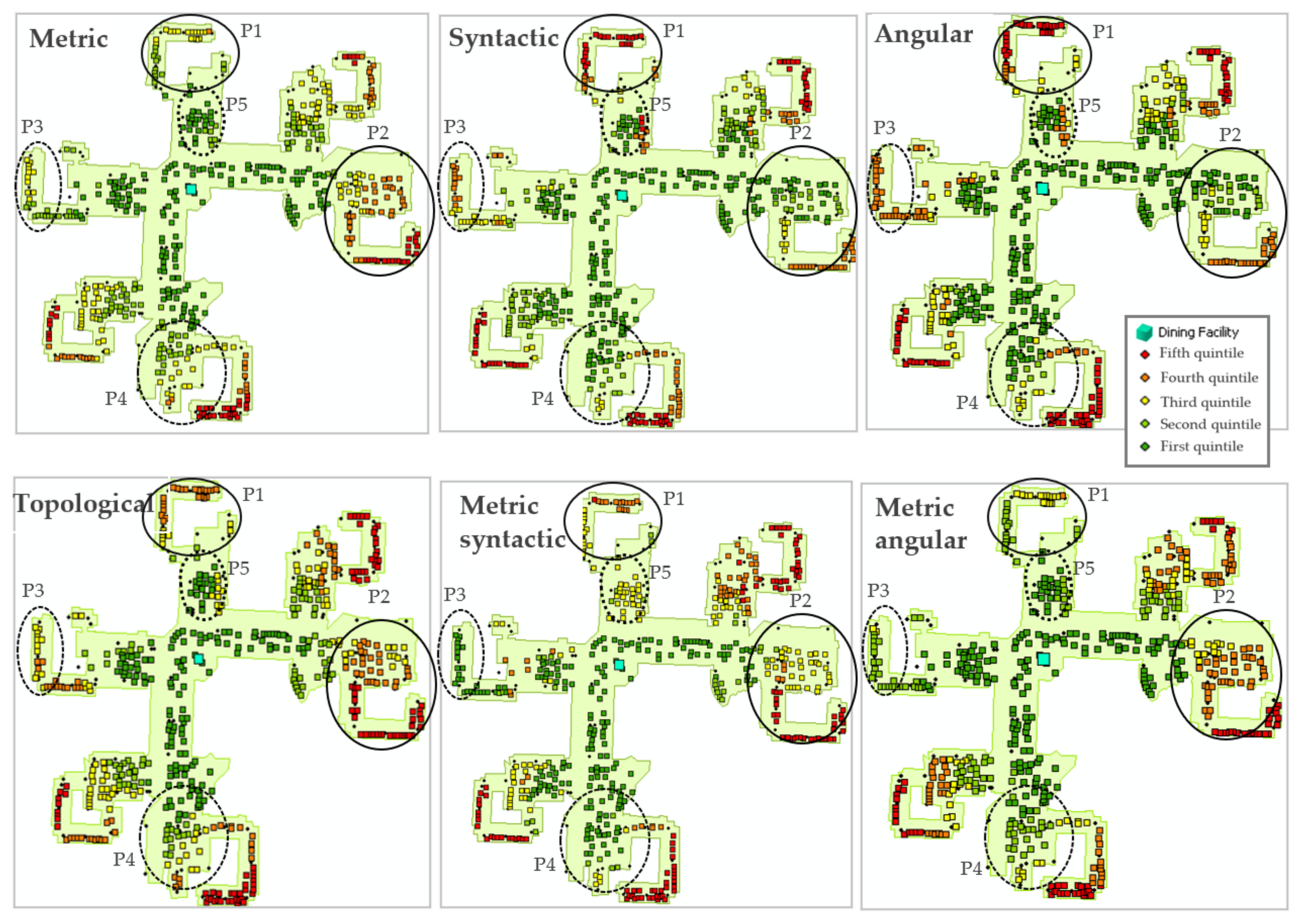
6. Case Study and Results

6.1. The Tested Indoor Environment

A complex residential building named Ellicott Complex on a college campus was chosen to test our modeling approach and strategy, illustrate its performance, and demonstrate the differences between the various ways to conceptualize movement and accessibility inside three-dimensional built structures. The objective here is to model the accessibility of the building’s rooms to dining facilities located inside the sprawling complex. The building is chosen for this experiment due to its complex spatial structure, both horizontally and vertically. It includes six quadrangles, namely Fargo, Porter, Red Jacket, Richmond, Spaulding, and Wilkeson, joined by the Millard Fillmore Academic Center (MFAC). An arial photograph of the Ellicott complex is provided in Figure A1. to provide context. It is a self-contained campus within a campus, where 3250 students enjoy a blend of living, learning, study, and recreational space. There are three dining facilities, located on the first floors of Red Jacket Quad (dining facility 1–DF1), of Richmond Quad (dining facility 2–DF2), and of the Millard Fillmore Academic Center (dining facility 3–DF3).
A 2.5D data model of the Ellicott Complex, including rooms, indoor transportation network, stairs and elevators, and its dining locations, was constructed and is shown in Figure 15. Traversable components for non-impaired pedestrians were considered when constructing this network. A network serving the impaired population was not implemented for this case study due to the complexity of the task. However, the implementation of the different modeling approaches proposed here is effectively demonstrated using the one for a non-impaired population. The implementation on the transportation network supporting impaired mode should be identical, with the only difference being the inputting network data infrastructure. Once this data network is built and ready for routing analysis, the metric accessibility analysis can be conducted. However, for syntactic and angular syntactic accessibility analysis, the main corridor travel arcs need to be resolved into strokes. The resolved strokes for every floor of the Ellicott Complex are shown in Figure 16.

6.2. Accessibility Modeling to One Facility

To better compare the results provided by various accessibility modeling approaches, the accessibility of the Ellicott Complex rooms to a single dining facility (DF3) is analyzed first. The metric, syntactic, and topological accessibility values of rooms to DF3 are visualized in Figure 17, while the angular, metric-syntactic, and metric-angular ones are in Figure 18. Generally, the metric approach classifies the accessibility of the rooms to DF3 based on the travel distance on the indoor transportation network. Because the location of DF3 is relatively centrally placed in MFC, rooms in MFC and adjacent spaces are shown to have high accessibility, while the accessibility of the six peripheral quadrangles have medium (yellow) to low (orange and red) accessibility, according to the quintile classification scheme. Rooms that are further away from the DF3 both in the horizontal (i.e., same floor) and vertical senses have lower accessibility. Unlike the metric approach, the syntactic and angular approaches classify most of the rooms in Wilkeson Quad and the rooms on the first floor of Fargo Quad as having high accessibility, because the paths from these rooms to DF3 are relatively straight. In addition, while most of the rooms in Richmond Quad and some in Red Jacket Quad are classified as having high metric accessibility because of the close proximity to DF3, they are have low syntactic accessibility due to the complexity of their paths leading to DF3. The metric-syntactic integrated approach fundamentally gives a blended result between the metric and syntactic approaches, and the result presented in Figure 18 demonstrates such an effect well.
To sharpen our focus, we can also look at the distribution of accessibility values to DF3 on a floor by floor basis for the purpose of comparing our six different approaches. Figure 19 does this for Floor 1. The resolved strokes on Floor 1 depicted in Figure 17 provide a syntactic visual for Floor 1’s layout, which can be used to assist in the analysis. Analyzing the accessibility patterns on Floor 1 gives better insights into the differences in results provided by approaches from the horizontal point of view. Ovals are used in Figure 19 to highlight several interesting points of analysis (P). Rooms identified as P1 and P3 denote representative areas that are only a short distance away from DF3 (i.e., have high metric accessibility) but syntactically far from DF3 (i.e., have low syntactic and angular syntactic accessibility). Conversely, areas at P2 and P4 are a long distance from DF3 (i.e., have low metric accessibility) but are syntactically close to DF3 (i.e., have high syntactic and angular syntactic accessibility). Rooms in area P5 are detected with high metric accessibility because of their relatively short distance to DF3. However, in contrast to the left-hand-side of the oval, the rooms on the right-hand side exhibit drastically degraded access according to the syntactic and angular approaches. This is because of the hallway design in this area (see Figure 17, Floor 1), which requires many syntactic turns to access these rooms.
To underscore how much accessibility may vary on different floors of a building, we use Figure 20 and Figure 21, which present the accessibility values by the metric and the syntactic approaches, respectively, on a floor by floor basis. The metric approach considers the metric distance, both horizontally along the network arcs and vertically along stairs and elevators. This means that, when a traveler moves between floors, the time required to traverse by stairs or elevators is taken into account. Thus, the travel impedance along vertical placement increases if the span of floors is larger. In other words, the higher the vertical placement of the room location from the DF3, the lower the metric accessibility values that room has. This is readily observed in the metric accessibility result reported in Figure 20 with the highlighted point of analysis P6 to P9.
The syntactic approach, however, does not consider the metric component (i.e., distance or travel time) of the vertical turns but rather its syntactic and cognitive component. Syntactically and cognitively, the impedance of every vertical turn equals 1, regardless of the absolute vertical displacement, meaning going from floor 1 to floor 2 or to floor 10 has the same syntactic and cognitive impedances. Additionally, the corridor layouts of different floors in MFC are very different syntactically. Therefore, depending on the travel path complexity, an increasing vertical movement does not need to cause a decrease in syntactic or angular accessibility. This is again clearly observed in Figure 21 with the same highlighted point of analysis P6 to P9. Specifically, in areas P6 and P9, rooms on higher floors generally have lower syntactic accessibility with respect to the DF3 than those on lower floors. In contrast, within area P7, rooms on Floor 2 or Floor 3 have higher syntactic accessibility to the DF3 than those on floor 1. This is because traveling from the second or third floor down to DF3 is less complex syntactically than from rooms on the same floor as DF3 (Floor 1).

6.3. Accessibility Modeling with Three Facilities

Let us consider now the situation where accessibility with respect to all three dining facilities are treated as possible sites of activities. Figure 22 and Figure 23 show the results for the accessibility evaluation of the building complex using different approaches in this case. The comparison of results among our six different approaches for Floor 1 is presented in Appendix B. In addition, the accessibility values by the metric and the syntactic approaches, respectively, on a floor by floor basis are presented in Appendix C and Appendix D.
In this scenario, the dining facilities are not scattered across the various parts of the complex, but instead they are clumped near each other, towards the Red Jacket and Richmond quadrangles. Differences between accessibility evaluation approaches in both the horizontal and vertical analyses are also observed for this more complex scenario. Generally, it can be seen that the rooms in the Red Jacket quadrangle, Richmond quadrangle, and the MFAC have higher accessibility to dining facilities, regardless of the modeling approach. When comparing the accessibilities of the spaces within these quadrangles estimated by different approaches, the syntactic and angular approaches successfully model the increase in syntactic or angular impedance when travel extends either horizontally or vertically away from the dining facilities. For instance, both syntactic and angular modeling approaches indicate rooms identified at P10 having low accessibility to the dining facilities, which is in line with the cognitive complexity of the paths, regardless of their short metric or topologic lengths.
In contrast, the rooms in Wilkeson and Fargo quadrangles identified at points of analysis P11 and P12 have low accessibility to the dining facilities based on the metric and topological models, while their accessibility is high using the syntactic and angular model. Compared to the accessibility results with respect to a single dining facility, the accessibility values obtained using three dining facilities are more spatially fragmented. This is clearly shown in the accessibility visualization for the syntactic and angular modeling approaches. This suggests that our modeling approaches are effective at capturing the syntactic complexity of the routes at a very fine spatial resolution and can suitably serve at modeling scenarios when cognitive impedances are essential.

7. Conclusions

In this paper, we stressed the importance of three-dimensionality for the accessibility analysis of built geographic space. As urban environments are expanded vertically around the world, spatial relationships can be best captured in all three dimensions rather than the conventional two-dimensional analytical approach. In addition, we have argued that accessibility evaluation should not be based purely on metric measures but also on the complex nature of the paths. A number of novel accessibility measures designed for indoor built geographic spaces and three-dimensional urban environments have been proposed and successfully developed and implemented in this study. The real-world tests show that place-based accessibility is highly sensitive to the indoor layout of geographic spaces. Also, the various measures of accessibility result, in some cases, in dramatically different spatial distributions in accessibility values. Effective visualization techniques were presented in this work to facilitate the rendering of complex results in a three-dimensional space.
This work presents a newly afforded ability to analyze and visualize built interior geographic spaces to study accessibility differentials in cities with vast vertical expansion. The analysis and visualization techniques presented in this paper may also be of use to building design practitioners in their work to design building layouts aimed at achieving (or at avoiding) specific accessibility outcomes. The work presented herein can be enhanced in the future to overcome its existing limitations. For example, future work can adopt a seamless indoor–outdoor urban environment [59,60] instead of only a single built structure. In this case, a 3D indoor–outdoor transportation network can be used instead of a 2.5D indoor network. Furthermore, network travel arcs of the case study can be enriched with accessible attributes to model inclusive accessibility for different population groups. Finally, while the work reported here is aimed at providing a visual output permitting the identification of indoor accessibility under alternative assumptions, a more formal quantitative comparison is also possible, and this avenue will be explored in future work.
This paper extends three intersections from bodies of literature, namely place-based accessibility, three-dimensional modeling, and indoor space syntax. It should be stressed that none of the various measures proposed in this paper should be considered superior to the others. Instead, each measure captures a different aspect of the interior layout of buildings. Therefore, it is reasonable to expect that different groups of individuals and different individuals within a social group would respond differently to the layout presented to them and that some measures would be tuned to the cognition and behavior of some individuals, while other measures would be best for others. Further research is warranted to ascertain the validity of this hypothesis and, if confirmed, the circumstances wherein each measure is of greater relevance. Although researchers have made long strides toward better understanding indoor pedestrian behavior, empirical tests that consider different traveler groups in different environments and contexts are still much needed. Research that integrates real-time accurate indoor positioning and visual-based accessible path detection with ecological momentary assessment technology [61] can be ideal for studying how a particular individual responds to and navigates in an indoor environment. User-based data can be used to validate and improve the existing accessibility models. Our modeling framework and the case study results presented here will serve as a baseline for these analyses. As a result, several advanced modeling options can be developed and integrated, including more extensive and dynamic sets of impedance criteria to handle urban topological complexities and user-based or context-based relevancies.

Author Contributions

Conceptualization, Thi Hong Diep Dao and Jean-Claude Thill; methodology, Thi Hong Diep Dao and Jean-Claude Thill; software, Thi Hong Diep Dao and Jean-Claude Thill; validation, Thi Hong Diep Dao and Jean-Claude Thill; formal analysis, Thi Hong Diep Dao and Jean-Claude Thill; investigation, Thi Hong Diep Dao and Jean-Claude Thill; resources, Thi Hong Diep Dao and Jean-Claude Thill; data curation, Thi Hong Diep Dao and Jean-Claude Thill; writing—original draft preparation, Thi Hong Diep Dao and Jean-Claude Thill; writing—review and editing, Thi Hong Diep Dao and Jean-Claude Thill; visualization, Thi Hong Diep Dao and Jean-Claude Thill. All authors have read and agreed to the published version of the manuscript.

Funding

This research received no external funding.

Institutional Review Board Statement

Not applicable.

Informed Consent Statement

Not applicable.

Data Availability Statement

Not applicable.

Conflicts of Interest

The authors declare no conflict of interest.

Appendix A

Figure A1. Arial photograph of the Ellicott complex.
Ijgi 11 00467 g0a1

Appendix B

Figure A2. Floor 1 accessibility by different modeling approaches to three dining facilities: classification in quintiles.
Ijgi 11 00467 g0a2

Appendix C

Figure A3. Metric accessibility to three facilities for different floors: classification in quintiles.
Ijgi 11 00467 g0a3

Appendix D

Figure A4. Syntactic accessibility to three facilities for different floors: classification in quintiles.
Ijgi 11 00467 g0a4

References

  1. Harris, A. Vertical urbanisms: Opening up geographies of the three-dimensional city. Prog. Hum. Geogr. 2015, 39, 601–620. [Google Scholar] [CrossRef]
  2. McNeill, D. The volumetric city. Prog. Hum. Geogr. 2020, 44, 815–831. [Google Scholar] [CrossRef]
  3. Handy, S.L.; Niemeier, D.A. Measuring Accessibility: An Exploration of Issues and Alternatives. Environ. Plan. A Econ. Space 1997, 29, 1175–1194. [Google Scholar] [CrossRef]
  4. Cascetta, E. Transportation Systems Analysis: Models and Applications, 2nd ed.; Springer: New York, NY, USA, 2009. [Google Scholar]
  5. Thill, J.-C. Transportation Applications of Geographic Information Systems. In Manual of Geographic Information Systems; Madden, M., Ed.; ASPRS: Washington, DC, USA, 2009; pp. 1035–1049. [Google Scholar]
  6. Páez, A.; Scott, D.M.; Morency, C. Measuring accessibility: Positive and normative implementations of various accessibility indicators. J. Transp. Geogr. 2012, 25, 141–153. [Google Scholar] [CrossRef]
  7. Kondyli, V.; Bhatt, M. Rotational locomotion in large-scale environments: A survey and implications for evidence-based design practice. Built Environ. 2018, 44, 241–258. [Google Scholar] [CrossRef]
  8. Coutrot, A.; Manley, E.; Yesiltepe, D.; Dalton, R.C.; Wiener, J.M.; Hölscher, C.; Hornberger, M.; Spiers, H.J. Cities have a negative impact on navigation ability: Evidence from 38 countries. bioRxiv 2020, 1–13. [Google Scholar] [CrossRef]
  9. Jiang, B.; Claramunt, C. A Structural Approach to the Model Generalization of an Urban Street Network. GeoInformatica 2004, 8, 157–171. [Google Scholar] [CrossRef]
  10. Hillier, B.; Iida, S. Network and psychological effects in urban movement. In COSIT 2005: Spatial Information Theory; Cohn, A.G., Mark, D.M., Eds.; Lecture Notes in Computer Science; Springer: Berlin, Germany, 2005; Volume 3693, pp. 475–490. [Google Scholar]
  11. Handy, S. Is accessibility an idea whose time has finally come? Transp. Res. Part D Transp. Environ. 2020, 83, 102319. [Google Scholar] [CrossRef]
  12. Jean, R.; Pereira, H.M.R. What are we missing when we measure accessibility? Comparing calculated and self-reported accounts among older people. J. Transp. Geogr. 2021, 93, 103086. [Google Scholar] [CrossRef]
  13. Zhang, L.; Chiaradia, A.J. Walking in the cities without ground, how 3d complex network volumetrics improve analysis. Environ. Plan. B Urban Anal. City Sci. 2022, 49, 1857–1874. [Google Scholar] [CrossRef]
  14. Thill, J.-C.; Dao, T.H.D.; Zhou, Y. Traveling in the three-dimensional city: Implementation issues and applications in route planning, accessibility, and location analyses. J. Transp. Geogr. 2011, 19, 405–421. [Google Scholar] [CrossRef]
  15. Dao, T.H.D.; Zhou, Y.; Thill, J.-C.; Delmelle, E. Spatio-temporal location modeling in a 3D indoor environment: The case of AEDs as emergency medical devices. Int. J. Geogr. Inf. Sci. 2011, 26, 469–494. [Google Scholar] [CrossRef]
  16. Dao, T.H.D.; Thill, J.-C. Indoor three-dimensional accessibility auditing for computer-aided architectural design. Trans. Geogr. Inf. Sci. 2018, 22, 288–310. [Google Scholar]
  17. Dykes, J.; Andrienko, G.; Andrienko, N.; Paelke, V.; Schiewe, J. Editorial—GeoVisualization and the Digital City. Comput. Environ. Urban Syst. 2010, 34, 443–451. [Google Scholar] [CrossRef]
  18. Eremia, M.; Toma, L.; Sanduleac, M. The Smart City Concept in the 21st Century. Procedia Eng. 2017, 181, 12–19. [Google Scholar] [CrossRef]
  19. Schweiker, M.; Ampatzi, E.; Andargie, M.S.; Andersen, R.K.; Azar, E.; Barthelmes, V.M.; Berger, C.; Bourikas, L.; Carlucci, S.; Chinazzo, G.; et al. Review of multi-domain approaches to indoor environmental perception and behaviour. Build. Environ. 2020, 176, 106804. [Google Scholar] [CrossRef]
  20. Carlson, L.A.; Hölscher, C.; Shipley, T.F.; Dalton, R. Getting lost in buildings. Curr. Dir. Psychol. Sci. 2010, 19, 284–289. [Google Scholar] [CrossRef]
  21. Chang, D.; Park, J. Quantifying the Visual Experience of Three-dimensional Built Environments. J. Asian Arch. Build. Eng. 2018, 17, 117–124. [Google Scholar] [CrossRef]
  22. Chang, D. Spatial Choice and Preference in Multilevel Movement Networks. Environ. Behav. 2002, 34, 582–615. [Google Scholar] [CrossRef]
  23. Hillier, B.; Hanson, J. The Social Logic of Space; Cambridge University Press: Cambridge, UK, 1984. [Google Scholar]
  24. Van Nes, A.; Yamu, C. Introduction to Space Syntax in Urban Studies; Springer Nature: Cham, Switzerland, 2021; p. 250. [Google Scholar]
  25. Turner, A. Angular Analysis: A Method for the Quantification of Space; Working Paper 23; Centre for Advanced Spatial Analysis, UCL: London, UK, 2000. [Google Scholar]
  26. Turner, A. From Axial to Road-Centre Lines: A New Representation for Space Syntax and a New Model of Route Choice for Transport Network Analysis. Environ. Plan. B Plan. Des. 2007, 34, 539–555. [Google Scholar] [CrossRef]
  27. Turner, A. The Role of Angularity in Route Choice: An Analysis of Motorcycle Courier GPS Traces. In COSIT 2009: Spatial Information Theory; Lecture Notes in Computer Science; Springer: Berlin, Germany, 2009. [Google Scholar]
  28. Jiang, B.; Claramunt, C.; Batty, M. Geometric accessibility and geographic information: Extending desktop GIS to space syntax. Comput. Environ. Urban Syst. 1999, 23, 127–146. [Google Scholar] [CrossRef]
  29. Jiang, B. A topological pattern of urban street networks: Universality and peculiarity. Phys. A Stat. Mech. Its Appl. 2007, 384, 647–655. [Google Scholar] [CrossRef]
  30. Jiang, B.; Zhao, S.; Yin, J. Self-organized natural roads for predicting traffic flow: A sensitivity study. J. Stat. Mech. Theory Exp. 2008, 2008, P07008. [Google Scholar] [CrossRef]
  31. Jiang, B.; Liu, X. Street-based topological representations and analyses for predicting traffic flow in GIS. Int. J. Geogr. Inf. Sci. 2009, 23, 1119–1137. [Google Scholar] [CrossRef]
  32. Hölscher, C.; Brösamle, M.; Vrachliotis, G. Challenges in multilevel wayfinding: A case study with the space syntax technique. Environ. Plan. B Plan. Des. 2010, 39, 63–82. [Google Scholar] [CrossRef]
  33. Wang, S.M.; Huang, C.-J. Using Space Syntax and Information Visualization for Spatial Behavior Analysis and Simulation. Int. J. Adv. Comput. Sci. Appl. 2019, 10, 510–521. [Google Scholar] [CrossRef]
  34. Kim, G.; Kim, A.; Kim, Y. A new 3D space syntax metric based on 3D isovist capture in urban space using remote sensing technology. Comput. Environ. Urban Syst. 2019, 74, 74–87. [Google Scholar] [CrossRef]
  35. Cooper, C.H.V.; Harvey, I.; Orford, S.; Chiaradia, A.J.F. Using multiple hybrid spatial design network analysis to predict longitudinal effect of a major city centre redevelopment on pedestrian flows. Transportation 2019, 48, 643–672. [Google Scholar] [CrossRef]
  36. Mandloi, D.; Thill, J.-C. Object-oriented data model of an indoor/outdoor urban transportation network and route planning analysis. In Geospatial Analysis and Modeling of Urban Structure and Dynamics; Jiang, B., Yao, X., Eds.; Springer: New York, NY, USA, 2010; pp. 197–220. [Google Scholar]
  37. Shiode, N. 3D urban models: Recent developments in the digital modelling of urban environments in three-dimensions. GeoJournal 2001, 52, 263–269. [Google Scholar] [CrossRef]
  38. Lee, J. A Three-Dimensional Navigable Data Model to Support Emergency Response in Microspatial Built-Environments. Ann. Assoc. Am. Geogr. 2007, 97, 512–529. [Google Scholar] [CrossRef]
  39. Shatu, F.; Yigitcanlar, T.; Bunker, J. Shortest path distance vs. least directional change: Empirical testing of space syntax and geographic theories concerning pedestrian route choice behaviour. J. Transp. Geogr. 2018, 74, 37–52. [Google Scholar] [CrossRef]
  40. ESRI. ArcGIS Indoors: Turn Your CAD and BIM Data into a Workplace Map. 2019. Available online: https://mediaspace.esri.com/media/t/1_r1tznq5f (accessed on 30 July 2022).
  41. Vanclooster, A.; Van De Weghe, N.; Fack, V.; De Maeyer, P. Comparing indoor and outdoor network models for automatically calculating turns. J. Locat. Based Serv. 2014, 8, 148–165. [Google Scholar] [CrossRef]
  42. Bongiorno, C.; Zhou, Y.; Kryven, M.; Theurel, D.; Rizzo, A.; Santi, P.; Tenenbaum, J.; Ratti, C. Vector-based pedestrian navigation in cities. Nat. Comput. Sci. 2021, 1, 678–685. [Google Scholar] [CrossRef]
  43. Hashemi, M. Emergency evacuation of people with disabilities: A survey of drills, simulations, and accessibility. Cogent Eng. 2018, 5, 1506304. [Google Scholar] [CrossRef]
  44. Zhou, X.; Xie, Q.; Guo, M.; Zhao, J.; Wang, J. Accurate and Efficient Indoor Pathfinding Based on Building Infor-mation Modeling Data. IEEE Trans. Ind. Inform. 2020, 16, 7459–7468. [Google Scholar] [CrossRef]
  45. Church, R.; Marston, J.R. Measuring Accessibility for People with a Disability. Geogr. Anal. 2003, 35, 83–96. [Google Scholar] [CrossRef]
  46. Kim, H.; Jun, C.; Cho, Y.; Kim, G. Indoor spatial analysis using space syntax. In Proceedings of the International Archives of the Photogrammetry, Remote Sensing and Spatial Information Science, Beijing, China, 3–11 July 2008; Volume XXXVII. Part B2. [Google Scholar]
  47. Mustafa, F.A.; Rafeeq, D.A. Assessment of elementary school buildings in Erbil city using space syntax analysis and school teachers′ feedback. Alex. Eng. J. 2019, 58, 1039–1052. [Google Scholar] [CrossRef]
  48. Cooper, C.H.V.; Chiaradia, A.J.F. sDNA: 3d Spatial Network Analysis for GIS, CAD, Command Line and Python. SoftwareX 2020, 12, 100525. [Google Scholar] [CrossRef]
  49. Thomson, R.C. Bending the axial line: Smoothly continuous road centre-line segments as a basis for road network analysis. In Proceedings of the 4th International Space Syntax Symposium, London, UK, 17–19 June 2003. [Google Scholar]
  50. Dalton, N.S.; Peponis, J.; Dalton, R. To tame a TIGER one has to know its nature-extending weighted angular integration analysis to the description of GIS road centerline data for large scale urban analysis. In Proceedings of the 4th International Space Syntax Symposium, London, UK, 17–19 June 2003. [Google Scholar]
  51. Figueiredo, L.; Amorim, L. Continuity lines in the axial system. In Proceedings of the 5th International Symposium on Space Syntax, Delft, The Netherlands, 13–17 June 2005; van Nes, A., Ed.; pp. 163–174. [Google Scholar]
  52. Jiang, B.; Liu, X. AxialGen_a research prototype for automatically generating the axial map. In Proceedings of the CUPUM 2009b, Hong Kong, China, 16–18 June 2009. [Google Scholar]
  53. U.S. Department of Justice. ADA Requirements: Wheelchairs, Mobility Aids, and Other Power-Driven Mobility Devices. Civil Rights Division Disability Rights Section. 2014. Available online: https://www.ada.gov/opdmd.htm#:~:text=Under%20the%20new%20rules%2C%20covered,facility%20where%20members%20of%20the (accessed on 24 August 2022).
  54. ADA National Network. Opening Doors to Everyone. 2017. Available online: https://adata.org/factsheet/opening-doors-everyone (accessed on 11 August 2022).
  55. Dijkstra, E.W. A note on two problems in connexion with graphs. Numer. Math. 1959, 1, 269–271. [Google Scholar] [CrossRef]
  56. Cascetta, E.; Cartenì, A.; Montanino, M. A New Measure of Accessibility based on Perceived Opportunities. Procedia Soc. Behav. Sci. 2013, 87, 117–132. [Google Scholar] [CrossRef]
  57. Hansen, W. How accessibility shapes land use. J. Am. Inst. Plan. 1959, 25, 73–76. [Google Scholar] [CrossRef]
  58. Chen, Y. The distance-decay function of geographical gravity model: Power law or exponential law? Chaos Solitons Fractals 2015, 77, 174–189. [Google Scholar] [CrossRef]
  59. Yan, J.; Diakité, A.A.; Zlatanova, S. A generic space definition framework to support seamless indoor/outdoor navigation systems. Trans. GIS 2019, 23, 1273–1295. [Google Scholar] [CrossRef]
  60. Yan, J.; Zlatanova, S.; Diakité, A. A unified 3D space-based navigation model for seamless navigation in indoor and outdoor. Int. J. Digit. Earth 2021, 14, 985–1003. [Google Scholar] [CrossRef]
  61. Shiffman, S.; Stone, A.A.; Hufford, M.R. Ecological momentary assessment. Annu. Rev. Clin. Psychol. 2008, 4, 1–32. [Google Scholar] [CrossRef]
Figure 1. Angular value, or the change in travel direction, in degree between two traveling arcs.
Ijgi 11 00467 g001
Figure 2. A long corridor represented as a composition of arcs (a) and as a stroke (b).
Ijgi 11 00467 g002
Figure 3. Floor turn representation.
Ijgi 11 00467 g003
Figure 4. Syntactic turn definition.
Ijgi 11 00467 g004
Figure 5. Angular cognitive turn definition.
Ijgi 11 00467 g005
Figure 6. Metric-weighted angular turn definition.
Ijgi 11 00467 g006
Figure 7. Topological break-point definition.
Ijgi 11 00467 g007
Figure 8. Metric impedance (minutes) of traveling paths and accessibility estimation with α = 2.
Ijgi 11 00467 g008
Figure 9. Syntactic impedance of traveling paths and accessibility estimation with α = 2.
Ijgi 11 00467 g009
Figure 10. Angular impedance of traveling paths and accessibility estimation with α = 2.
Ijgi 11 00467 g010
Figure 11. Topological impedance of traveling paths and accessibility estimation with α = 2.
Ijgi 11 00467 g011
Figure 12. The metric-syntactic impedances of traveling paths and accessibility estimation with α = 2.
Ijgi 11 00467 g012
Figure 13. The metric-angular impedance of traveling paths and accessibility estimation with α = 2.
Ijgi 11 00467 g013
Figure 14. Accessibility estimation workflow.
Ijgi 11 00467 g014
Figure 15. 2.5D model of the Ellicott complex and its dining locations.
Ijgi 11 00467 g015
Figure 16. Strokes identified on each floor of the test complex.
Ijgi 11 00467 g016
Figure 17. Metric, syntactic, and topological accessibility to dining facility 3: classification in quintiles.
Ijgi 11 00467 g017
Figure 18. Angular, metric-syntactic, and metric-angular accessibility to dining facility 3: classification in quintiles.
Ijgi 11 00467 g018
Figure 19. Floor 1 accessibility to dining facility 3 (P = point of analysis, highlighted for comparison among different approaches) based on different approaches: classification in quintiles.
Ijgi 11 00467 g019
Figure 20. Metric accessibility to dining facility 3 on different floors: classification in quintiles.
Ijgi 11 00467 g020
Figure 21. Syntactic accessibility to dining facility 3 on different floors: classification in quintiles.
Ijgi 11 00467 g021
Figure 22. Metric, syntactic, and topological accessibility to three dining facilities: classification in quintiles.
Ijgi 11 00467 g022
Figure 23. Angular, metric-syntactic, and metric-angular accessibility to three dining facilities: classification in quintiles.
Ijgi 11 00467 g023
Table 1. Transportation data network components and impedance value for different accessibility evaluation approaches.
Modeling ApproachTravel Network ComponentsImpedance Value
MetricNetwork stroketc (minutes)
Floor turnte or ts (minutes)
SyntacticNetwork stroke0
Floor turn1
Syntactic turn (i.e., the junction of 2 or more strokes)1
AngularNetwork stroke0
Floor turn1
Angular turn (i.e., turning angle θ of 20o or more between travel arcs) 180 180 θ
TopologicalNetwork stroke0
Floor turn1
Topological break point (i.e., the junction of 3 or more arcs)1
Metric-SyntacticNetwork stroketc (minutes)
Floor turnte or ts (minutes) + 1
Syntactic turn1
Metric-AngularNetwork arctc (minutes) as the weight of the next angular turn
Angular turn 180 180 θ
Floor turn1
Table 2. GIS feature classes in the data network.
Indoor 3D Traversal ComponentsGIS Feature Data Type
RoomsPoint
Exit points (stairs/elevators)Point
Floor turnsPolyline
Floor network arcsPolyline
Floor network strokes (continuous arcs of 30° or less)Polyline
Syntactic turns (between strokes)Point
Angular turns (between arcs of 20° or more)Point
Topological breakpoints (between 3 or more arcs)Point
Publisher’s Note: MDPI stays neutral with regard to jurisdictional claims in published maps and institutional affiliations.

