1. Introduction
Traveling to school is one of the most sensitive mobility behaviors in terms of road safety, given that the main protagonists are children. It is estimated that daily school trips account for seven out of ten journeys undertaken by children between 5 and 18 years of age. These data make the protection of the most vulnerable road users, which include children [
1], the elderly, cyclists, and pedestrians [
2], one of the priorities of the Road Safety Strategy of the Directorate-General for Traffic (DGT) of Spain, which is why this type of travel is of particular interest for analysis. According to the research of [
3], 70% of Spanish children do not travel to school alone. Furthermore, most of them walk accompanied on many occasions by parents or grandparents, especially in small towns. This fact reinforces the presence of vulnerable users in these school trips, as they often involve pedestrians, including the elderly and children.
The initiatives of the 15-Minute City that are being implemented in multiple cities around the world in recent years [
4,
5,
6] have demonstrated effectiveness in creating friendlier and safer environments for pedestrians and wheelchair users globally. However, school mobility remains a mode of travel that requires specific analysis since the significant number of students, in coexistence with other means of transport—according to [
3], school or public transport accounts for 18% and private vehicles for 40%—adds another risk factor for traffic accidents. This, together with the seasonal nature of these movements, concentrated at school start and end times, causes occasional congestion in areas close to schools, and various traffic conflicts that place drivers and pedestrians at risk. If we add to this the incorporation of private transport, collective transport, cyclists, and pedestrian traffic, we can see that school trips generate a particular form of mobility that must be addressed from a special approach compared to other types of traffic-generating activities. In this field, stand out studies include [
7], which analyzes the Green and Safety School program in the Calabria region, or [
8], studying the availability and state of conservation of sidewalks as a fundamental element for the improvement of pedestrian mobility in urban areas.
In Spanish schools, bus routes are regulated by [
9], which publishes some general criteria to be taken into account when defining bus routes. However, the lack of regulation to define pedestrian routes means that most schools do not have defined pedestrian routes. It is generally the schools themselves or organizations in charge of promoting sustainable mobility [
10,
11,
12,
13,
14] that promote these routes considering the students’ addresses based on information recorded on their registration forms, simply prioritizing the proximity to the school. Knowledge of the location of the student’s homes is essential with respect to establishing appropriate mobility policies in each of the educational centers for planning general public and school public transport routes. To design a safe school route, it is important to account for aspects such as the state of the streets, their technical characteristics, the location of obstacles for pedestrians or wheelchair users, or the location of possible problematic points on routes that may affect the safety or comfort of pedestrians. Acquiring this information is currently possible through collaborative participation; however, transferring this information to a Geographic Information System (GIS) that allows their integrated analysis with road data and other territorial information, requires the use of complex geopositioning processes, in addition to the data protection criteria that must be met. Most surveys conducted thus far focus on identifying the mobility of a population based on generic geographic references, such as municipal environments. However, there exists a scarcity of published literature that focuses on the real and detailed location of the origins and destinations of users because they require significant resources for performing adequate analysis. On many occasions, they simply work with a combination of travel times and distances. For instance, in the work of [
15], the authors’ design project employs a questionnaire on mobility, but without offering specific locations regarding origin points of the trips. Novel information and communication technologies offer an infinite number of new possibilities to citizens and administrations, which they are applying more or less rapidly to their activities. In addition, they offer services that many researchers can use in their projects to obtain data of high scientific value that would otherwise be impossible to acquire by traditional means, as [
16], that identified different levels of walkability of a pedestrian network or [
17], that uses multiple information sources to model city infrastructure and to calculate accessible routes. Studies such as [
18] show that the increasing focus on sustainable travel has generated a demand for pedestrian and cyclist travel data acquisition and management. Notably, an increasing number of tools for mobility information acquisition are becoming available. However, obtaining information directly from those involved in mobility is something that has not been studied in depth until now. This is the case of geolocation web techniques, which make it possible to obtain the geographic location of respondents in addition to those of a given number of questions asked online. These methodologies confirm the assertion of [
19] that 100% of the information and data handled globally have a spatial component that allows them to be referenced on the territory. As a result of this idea, the Emapic initiative arises, which will be the application on which the data acquisition for this project is developed, as we will detail in the following section. However, among the technologies for creating geo-referenced surveys, there are also other initiatives present within what we can include in public participation geographic information system (PPGIS). We can cite some such as Maptionnaire, used for example in participatory mapping of cultural ecosystem services in Madrid [
20] or for understanding children’s neighbourhood destinations in Auckland, New Zealand [
21]; Ushahidi, an open source software application based in volunteered geographic information (VGI) used in projects such as citizen earthquake science in Taiwan [
22] or a surveillance system for road traffic crashes in Burkina Faso [
23]; ArcGIS Survey123, a simple and intuitive form-based data capture solution for creating, sharing and analysing surveys within the ArcGIS system promoted by ESRI used for example in a study on tourism-related stress [
24] or to study the impacts of the COVID-19 pandemic [
25].
An essential function in the life of a municipality is the level of mobility of its citizens. Knowing how they move and the route they use to access a particular public facility can help to establish policies and mobility plans focused on the needs of each of them. Geolocated survey technology makes it possible, in addition to locating the respondent, to request information on the linear routes they take or the identification of conflictive points in their journeys, among other issues of interest. If the mobility of daily users of a public center (for example, an educational center) is studied with precise geographic data, it is possible to obtain relevant data to establish sustainable mobility policies. This will make it possible to promote safer and more adequate pedestrian routes on the most frequented routes, adapting public transport in the area or promoting forms of shared trips.
This work aims to examine the scope of our geolocated survey web application Emapic (
https://emapic.es/ (accessed date: 28 August 2022)) as a tool to acquire georeferenced information on school mobility, to study the characteristics and specificities of the students’ journeys to their respective schools. The tasks carried out are part of the Geomove (
https://cartolab.udc.es/geomove/ (accessed date: 28 August 2022)) project, in which the specific case of different schools in Galicia (Spain) has been studied. This region, located in the northwest of Spain, has a population of 2,695,645 inhabitants, according to [
26], with the majority residing in main cities (Vigo, A Coruña, Ourense, Lugo, Santiago de Compostela, and Pontevedra) and coastal municipalities located in the southwest of the region, well connected by road through the AP-9 highway. However, the population in Galicia is characterized by its dispersion, especially in rural areas, which generates a unique type of mobility.
In
Section 2, the scheme of the web application Emapic (
https://emapic.es/ (accessed date: 28 August 2022)), the specific developments created for mobility analysis and the sample obtained in the case study of this work are described. In
Section 3, the results obtained are shown; in
Section 4 these results are discussed and compared with those obtained in other related works. Lastly, in
Section 5 concluding remarks are provided.
2. Materials and Methods
The methodology used in this work was divided into two main phases: (I) developing the technology necessary to carry out the geolocated surveys and (II) analyzing the data obtained from the surveys to extract results and conclusions on school accessibility in the participating centers.
2.1. Development of a Geolocated Survey System
To develop a web tool for geolocated surveys where geographic reference was a fundamental aspect of the surveys, it was necessary to improve the functionalities of the Emapic (
https://emapic.es/ (accessed date: 28 August 2022)) application, developed by the Advanced Visualization and Cartography Group of the University of Coruña, and adapt them to the specific requirements of this project. These improvements include the creation of a multi-parametric web map viewer, which allows identifying the geographical location of the schools and, at the same time, collecting of the user’s location thanks to automatic or manual location strategies, associating all the user’s answers to their geographical representation. This allowed analysis of the acquired data not only statistically, but also spatially. In addition, this application offers the possibility to survey an unlimited number of students and educational centers, without the need to implement additional resources if the survey is extended to a larger number of respondents, regardless of their location or size.
2.1.1. Emapic
Emapic (
https://emapic.es/ (accessed date: 28 August 2022)) is a web tool whose function is to carry out geospatial surveys, combining the alphanumeric data collection of traditional online surveys with the possibility of adding the geographic component of the user’s location, allowing both the visualization of the data on a map and the obtaining of more complex geometric analysis and correlations between the answers and their geographic areas.
It is a web development made with a set of HTML5, CSS3, and JavaScript technologies. As a general JavaScript library jQuery is used and for the layout, Bootstrap is used as a base, complemented for more complex elements of the user interface with jQueryUI (jQuery extension). For queries, filtering, and data representation, the Javascript libraries Crossfilter, D3.js, and dc.js are used, in the latter two cases, especially for use in the representation of statistical graphs. For cartography, there is a geographic viewer made with the open-source JavaScript library Leaflet, which uses HTML5 and CSS3 for the representation of interactive maps on the web. The viewer has different elements of interaction with the map already offered by Leaflet. The cartographic layers used in the viewer are taken from OpenStreetMap (OSM) and satellite images provided by Mapbox, although there is the option of using other cartographic web services.
The server code is based on node.js, storing the data in a PostgreSQL database with the PostGIS module, which allows storing and processing of the geographic component. The project, and especially the data model, was inspired by many of the functionalities present in the free software project LimeSurvey. The application receives the survey data from the server in Geojson format, a variant of the Json format for storing JavaScript objects in plain text, which also includes spatial information.
Figure 1 shows the structure of Emapic (
https://emapic.es/ (accessed date: 28 August 2022)) and its code is published in Github/Emapic (
https://github.com/Emapic/emapic (accessed date: 28 August 2022)).
2.1.2. Specific Customization for the Geomove Project
The specific developments on Emapic (
https://emapic.es/ (accessed date: 28 August 2022)) for the Geomove (
https://cartolab.udc.es/geomove/ (accessed date: 28 August 2022)) school mobility project consisted in the creation of two questionnaires that have been translated into Spanish, Galician and Valencian languages.
The first questionnaire [
27] was used as a registration form for schools that wanted to take part in the project. The questionnnaire is employed to gather data about the school and its contact staff:
School name
Type of school financing: public, charter, or private school
Number of students, teachers, and other workers
Educational levels taught at school: child education, primary education, secondary education, high school, vocational training, or of other types
Once this first form is sent, the data are stored in the Emapic database, reviewed manually, and then copied into another table in the database that stores only validated registrations. In this table, a unique password is assigned to each participating school and, by using this password, all persons belonging to that school can start answering the main questionnaire. This second questionnaire [
28] allowed for an in-depth analysis of multiple questions that can group into four main categories:
Characteristics of the respondent (student or center personnel). Although it is not necessary to identify information about the respondent, certain data of interest such as gender, academic year, etc., are requested.
Mobility habits: modes of transport, timetable, companions.
Perception of the route and preferences: services, safety, type of roads, etc.
Cartographic data: location of the home, route layout, identification of troublesome points, etc.
To make it easier to understand and answer these web questionnaires, each participating school was sent a user’s manual [
29] that detailed the methodology to be followed.
Another improvement was to provide each survey with different spatial geometries. As can be seen in
Figure 2, each participant could locate their home as a point, draw the route from their home to the school as a line, and locate problem points encountered along the route, up to a maximum of five points.
The location of the participant’s address is a mandatory element in the process of answering the questionnaire. To facilitate the location, a map of the area surrounding the participant’s school is presented, which is already identified since the individual school password must be entered to enter the form. As school registration is an earlier process in which the geographical location of the school is also mandatory, this information is always available before students and teachers, or school staff participates. Once the point marking the location of the participant’s home is available, it is possible to trace the route usually followed to travel from home to school. The system allows a line to be drawn that obligatorily connects the point of the home with the point of the educational center. This part of the questionnaire is optional, so if a student has difficulties drawing it, due to age, time, or any other reason, he/she can omit this step. It is allowed to zoom and change the cartographic background to get the clearest information to detail the route of the displacement with the maximum level of detail that each participant wants to use. It is also left as an optional step to indicate on the route some conflicting points (up to a maximum of five) or that present problem in the route. These points are characterized among several types (traffic, sidewalk, crossing, traffic light, or other) to be able analyzed later. In addition, comments can be added, both at these trouble spots and in other sections of the questionnaire.
2.2. Data
For the development of the project, data collection was carried out between May and December 2016. In total, 26 schools participated and the geographical dispersion of the centers studied covered 18 municipalities and the four Galician provinces. Most of the schools were located in urban populations and four in a rural environment. Of the total number of schools studied, 25 were public schools and 4 were charter schools. Regarding the number of participants, 1903 were students and 73 were school staff, this group comprised both teachers and other workers so the total sample studied was 1976 participants. A web map (
https://emapic.es/custom/geomove-16/overview (accessed date: 28 August 2022)) has been created to collect the location, identification, and a number of participants of all the centers enrolled in the project.
The data acquired with the questionnaires has automatically stored in the Emapic (
https://emapic.es/) database (a PostgreSQL (
https://www.postgresql.org/ (accessed date: 28 August 2022)) relational database with geospatial support via PostGIS (
https://postgis.net/ (accessed date: 28 August 2022)) in two different tables: one for the school registration form, and another for the main questionnaire that gathers the mobility data from school personnel and students. The full structure of these tables can checked in
Appendix A. During the analysis, new tables have created to store intermediate data obtained when processing the original tables, associating different types of information. For the geostatistical analysis of the information, the computer programs R (
https://www.r-project.org/ (accessed date: 28 August 2022)) and QGIS (
https://www.qgis.org/en/site/ (accessed date: 28 August 2022)) were used.
2.2.1. Filtering and Debugging of the Obtained Data
Checking and Filtering of Age and Course Correspondence
Data checking and filtering outliers between the age and course fields were basic to avoid inconsistent results in the study. For this purpose, the theoretical ages of the pupils were established according to the level of education they claimed. Subsequently, this age was compared with the theoretical age of the course and a range of validity was obtained between −1 and +2 years. If the age and course data did not agree, both were excluded from the study. Of the 1903 initial records, 87 were discarded, finally obtaining 1826 records. The theoretical ages of the students according to the corresponding course are shown in
Table 1.
Checking and Filtering of Home–School Route Times
Knowing the time of departure from home and arrival at school on the day of the survey, given by the respondents, we obtained the travel time that each student estimated he/she spent. To check the veracity of this time, two filters were established: one to eliminate times of less than 0 min and more than 120 min, and another to eliminate all times that were not within a range of
of the theoretical time needed to travel the indicated route. In the latter case, the route between the indicated address and the corresponding school was previously calculated using the [
30] algorithm and the distance obtained was given a travel time based on theoretical speeds established for each means of transport in previous studies such as [
31,
32]. These speeds were 4 km/h for pedestrians, 10 km/h for bicycles, and 30 km/h for motor vehicles. With the first restriction, 130 records cleaned, obtaining 1773 results, and with the second restriction, 1329 records cleaned, obtaining 574 valid data for route times. The travel time values that could be correctly validated were subsequently analyzed in the geospatial analysis.
Checking and Filtering of Family Data
The data acquired on the number of cars, bicycles, children, and persons in the respondent’s household were filtered. In total, three filters were used:
Number of cars and bicycles. All negative values and values greater than 10 were eliminated for both the number of cars and bicycles
Number of children: values less than 1 and greater than 10 were eliminated for the number of children. In this case, the minimum value for each record was 1, since the wording of the question required the respondent student to be included in the count of children in the family
Number of people: values less than 2 and greater than 10 whose ages were less than 16 years were eliminated
Home–School Route Distances Debugging
Of the total 1903 participating students, only 865 drew their home–school route. To validate these routes, the distance between home and school checked to ensure that it was greater than the distance in a straight line. In addition, the optimal route between the two points was used, comparing the distance of the drawn route with the distance of the optimal route obtained by network analysis. A validity range was established for drawn lengths between 70% and 130% of the optimal route. With these restrictions, a total of 608 records retained, 70% of the routes drawn.
Final Filtering of Student Data
A final count of all previously filtered records was performed to eliminate those containing a high number of null values (
Table 2). Records with errors in three or more filters were removed from the study.
2.2.2. Description of the Sample
The sample obtained consisted of 1883 participants and 26 educational centers in 16 different municipalities. Of these 26 educational centers, 22 were located in urban environments and 4 in rural areas. In terms of ownership, 22 were public schools and 4 were charter schools.
Table 3 shows the list of participating schools, the basic data of the center, and the percentage of participating students.
The educational levels of the participants ranged from Child Education to High School, although the majority (69.4%) were between 5th Primary school and High school. The average age was 12 years and the gender distribution was balanced, with 943 female and 939 male students. Regarding their height, this presents a parameter of interest since the legal limit by which children must be seated in a restraint seat is set at 135 cm, according to [
33], 1719 respondents measured taller than 135 cm and only 164 did not reach that height.
Students responded to the survey in three different ways: from school, with the help of a teacher or Geomove project staff, or from home, either with the help of a family member or on their own. According to the data obtained, 1687 surveys were answered from school, with the help of teachers, compared to 106 who answered from home with help and 90 alone.
Analyzing the number of home–school routes drawn by the students, 30.9% of the participants drew the route without errors. However, this percentage was not high enough to analyze the school routes, so we studied the optimal routes calculated from the location of homes and schools using GIS procedures and then worked with these calculated routes to serve 100% of the participants.
2.3. Statistical-Descriptive Analysis
A statistical-descriptive study of the data acquired was carried out to obtain a more effective reading, using frequency tables, histograms, or box plots, among other methods. The information acquired was divided into four groups, depending on the subject matter, (1) respondent characteristics (sex, academic level, etc.), (2) mobility habits (mode of transport, schedule, companions, etc.), (3) perception of the route and preferences (services, safety, type of roads, etc.), and (4) cartographic data, such as the location of the home, layout or identification of conflictive points.
2.4. Geospatial Analysis
The use of web map viewers to carry out online surveys on school mobility has made it possible to have at the same time the alphanumeric answers and the geographic locations of different elements consulted to the respondents. In particular, the location of the home address, the linear layout of the home–school route, and the location of problems along the route. All these spatial geometries are linked to the anonymous user who entered information in the questionnaire and are also directly related to the school to which the respondent belongs, whose geographical location is available. By visualizing the different elements provided (address, route and problems) on a map, the following information was already available:
A representation of the area of influence of each school by the position of the addresses concerning the location of the center
A reference of the most used streets in the routes to travel to the center
A representation of the places near the school that presented some kind of problem
Using the potential of GIS and the different associated technologies, such as Web Map Services (WMS), Spatial Data Infrastructures (SDI) and geographic databases available on the Internet, it was possible to analyse the data obtained in the survey in depth. For this project, in which this type of information was obtained for the first time, the analyses carried out were:
Optimal home–school routes: the study of distances between homes and schools, establishment of zoning by distances to each school, and analysis of the concentration of routes by road sections
Analysis of the density of homes near the schools: count of homes in the area generated by distances to each school
Analysis of the spatial concentration of problems in the routes
For the calculation of the optimal routes, network analysis has been proposed based on the vector and topological information of the road network provided by OSM, on which a calculation of optimal routes and paths was performed through the PgRouting service. The calculation of the optimal routes was carried out with the [
30] algorithm, evaluating the possible routes, using only the existing roads within a maximum radius of 5 km concerning the bounding box defined by the location of the home and the school. The cost of road optimization calculation was established according to the length of the route, so the shortest distance routes were obtained through the network mapped in OSM. Once these routes were available, we identified those road sections (defined as lines between two intersection nodes) that had the highest frequency of use due to the coincidence of several routes of students going to the same school. The number of times that a student potentially used that section to get to school was counted, storing this value on the geometry of the corresponding section for later analysis, but without individually identifying any of the participants, so that only sections with more than three students were represented.
Another of the analyses performed was the identification of the zones of influence of each school, calculated as those places that can be reached by walking a certain distance along the road. The zones were compared with other studies that provided equivalences between walking times and distances traveled, such as [
34]. The distance zones were as follows:
First zone of 400 m, corresponding to 5 min of walking at a speed of 4.8 km/h
Second zone up to 750 m, corresponding to 10 min of walking at 4.5 km/h
Third zone up to 1000 m, corresponding to 15 min of walking at 4 km/h
Fourth zone up to 2000 m, corresponding to 30 min of walking at 4 km/h
4. Discussion
To carry out this study, it was essential to develop specific functionalities on Emapic (
https://emapic.es/ (accessed date: 28 August 2022)) to associate a geographic component to each question of the survey, which added value to the results. These improvements made it possible to generate a questionnaire on school mobility suitable for all ages thanks to a functionality that allowed participants to select for each question a response of varying complexity, according to the age of the students. In this way, younger students were able to answer the questionnaire in a straightforward manner, and older students or those with greater interest in the subject had the possibility of providing additional and more precise information to the study.
It was observed that the most difficult questions for the students were those related to the location of certain elements on the map, especially when they had to draw the route from home to the educational center, which was correctly digitized by 31.0% of the respondents. This value is relatively low; however, considering that it was the first time that many of the participants used editing tools on a map, and in a web system, it can be considered adequate. It is worth noting that the centers that had personal support from a member of the project team achieved more accurate answers, with significant differences being noted especially in the questions that involved a geographic component.
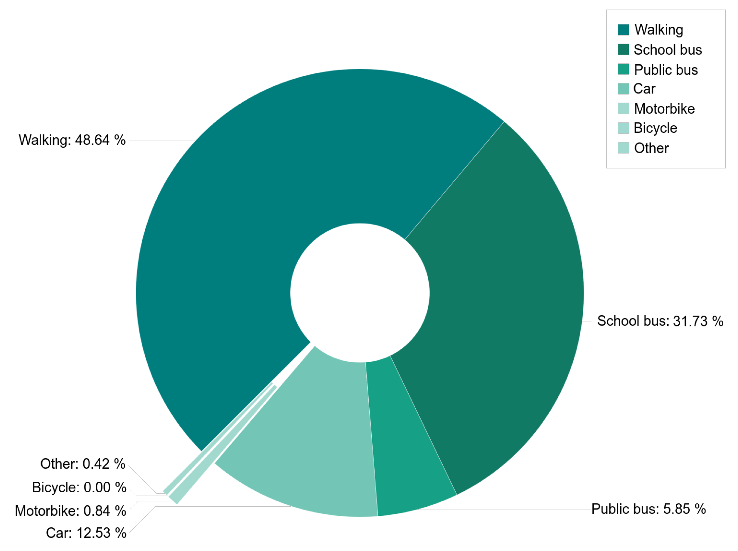
After analyzing the responses, the results show that the most common means of travel were via car, used mainly in rural areas, and walking. These results agree with those obtained in other studies such as [
35] or [
3]. Some of the reasons that justify the frequent use of car as transport include the usual rainy weather in Galicia and the need to carry heavy school materials, also found in [
35], while students who usually walk do so motivated by physical exercise and by producing less environmental pollution. The time taken to travel was the issue that most concerned the respondents. Most students took 20 min or less to reach school grounds. There is a widespread belief that walking is slow; however, according to the results obtained, it was found that the fastest trips were those made on foot and by car. It was also observed that the combination of different means of transport is quite widespread among the population analyzed, with the most common connection being the school bus in conjunction with car transport. Although the car was the most used means of transport, the students responded that they would prefer to travel on foot or by bicycle if they had the opportunity to choose their transport. This result is surprising since only 29 of the 1883 respondents indicated bicycles as their usual means of transportation, being used preferably for recreational purposes. On the other hand, the low preference shown for the public bus is remarkable, representing only 2% of the participants.
Traffic and traffic jams are important factors when assessing the value of commuting to school, especially in urban environments. Most students who travel by car or public bus suffer from traffic jams caused by the poor flow of vehicles and a large number of badly parked or double-parked cars, a common habit in the vicinity of schools at school start and finish times. Pedestrians and cyclists also suffer regularly from the invasion of sidewalks or bike lanes by cars, which forces them to avoid them, sometimes having to do so by joining the road. On the other hand, bicycles were the least appreciated, and users of this type of transport were the ones who rated the journey least highly, with only 5.6% of the frequencies. Other mean of transport with the worst perception of travel was the public bus, although these results should be read with caution because this may be due to the low use of this means of transport by those surveyed. After all, only 5.5% of the students said they used this service. On the other hand, the school bus and walking were the most valued means of transport by users in terms of their overall perception of the journey, despite not being the fastest combination. Half of the respondents who walked and took the school bus indicated that their journeys were pleasant. Likewise, the motorcycle users regarded their trips as pleasant, although, on this occasion, the frequencies obtained were significantly lower.
Studies, such as [
36], indicate that the age of the students marks the way they travel to school. In our study, we found that in early ages it was the parents, followed by the grandparents, who usually accompanied children to school, while in advanced courses they usually went alone or with friends, establishing 2hd Secondary Education as the educational level that marks a turning point between both habits. The objective of multiple municipal programs is to promote the autonomy of students on these routes since in addition to promoting child autonomy, it is possible to reduce pollution and the risks caused by the vehicles that come every morning to take children to school [
37].
The most common elements found on the routes were pedestrian crossings, lowered curbs (closely related to crosswalks), and pedestrian traffic lights at intersections, elements that expedite and provide safety for pedestrians. However, in agreement with [
38], the lack of pedestrian-only streets and green areas, which with a large number of narrow sidewalks, were a source of dissatisfaction on the part of pedestrians, stood out.
All students, regardless of the means of transport used to get to school, must walk at least a small part of their journey, so it is important to know how they behave on these trips. According to results, approximately 62% walked on the sidewalk, 47% looked at both sides of the road before crossing it and 40% crossed at the established crosswalks. These values were too low to refer to issues that should be mandatory, so they should be studied in greater depth in future studies, to influence and encourage more appropriate behaviors. Likewise, more than half of the school bus users did not expect it at the bus shelter, so the reason for this should also be analyzed.
Regarding habits during car journeys, only 73% of the students always fastened their seat belts, and, of those under 135 cm, 70% sat in the back seat of the vehicle and 26% did not use the child restraint seat. These data are worrying, as the participating students did not freely select issues that should be fundamental habits for road safety.
Finally, it was observed that, although the average school travel distance in the sample analyzed was 2593 m (a greater distance than that found in other studies such as [
39], where the average distance was 1623 m), the majority lived less than 1 km from their school, 16% of whom lived between 400 and 750 m away. These distances are feasible for daily walking and cycling, as shown in [
34]. Even with these distances, the private vehicle was the most commonly used mode of transport.
5. Conclusions
In this study, we proposed an analysis of school accessibility based on data acquired through a web system of geolocated surveys, Emapic (
https://emapic.es/ (accessed date: 28 August 2022)). This subsequently allowed us to add a spatial component to any type of information captured through an online questionnaire. For this purpose, several specific developments were made to obtain a battery of valid questions to be answered by different student profiles, regardless of their age. One of the main weaknesses encountered during the process was that the questions related to the identification and drawing of geographical features on the map were overly complicated for some of the students surveyed. Some school house routes or the specific location of certain problem areas were not correctly located or not answered, forcing the use of routes obtained through a routing algorithm [
30] instead of being able to directly use those obtained in the survey for the pedestrian accessibility analysis. It was also found that the accuracy of the surveys increased significantly when students were tutored by a subject matter expert who guided them through the questionnaire response process, rather than being guided by a teacher or answering the questionnaire autonomously.
Although the preferred means of transport for the students were cycling and walking, most home–school trips were undertaken by car and walking in urban environments, and only a minority used a bicycle as a means of travel, using it only for recreational use, regardless of student age and the environment in which they live: urban or rural. Proof of this was that most of the students surveyed lived less than 1 km from the school in urban environments, distances accessible to most pedestrians and cyclists and, despite this, the majority of trips were made by private vehicle. The reasons given by the students were mainly to avoid bad weather and the need to carry heavy school materials.
It is worth highlighting the habits of students when making their journeys, both on foot and by car, since although most of them complied with the established road traffic regulations, approximately a quarter of those surveyed did not use seat belts, child-restraint seats for children under 135 cm, or crossed the street without looking both ways and without using the obligatory pedestrian crossings. Finally, the usefulness of Emapic (
https://emapic.es/ (accessed date: 28 August 2022)) as a tool for acquiring thematic data with associated geographic information has been demonstrated. The acquired data are very useful for application across multiple studies, such as school mobility studies, as described in this work. Regarding future lines of research, it would be of great interest to analyze all schools within the same city to assess the school routes comprehensively, analyzing the sections of greatest interest for each school. The data obtained would be essential for the schools themselves in order to manage their school routes more efficiently. We are also working on identifying patterns of responses based on the geographic location of participants to locate trends associated with socioeconomic, demographic, or urban characteristics of the areas where respondents reside. In addition, we would like to enhance Emapic (
https://emapic.es/ (accessed date: 28 August 2022)) so that it can also be used to add thematic information to studies on the characterization of pedestrian routes and the generation of more efficient pedestrian accessibility models.


