1. Introduction
Iraq confronts severe water challenges as a result of internal as well as external factors, such as ineffective management of its water resources, internal disputes over politics, and tense ties with its neighbors, particularly Iran, Turkey, and Syria [
1]. The average surface water discharged to Iraq through the Tigris and Euphrates Rivers is anticipated to decline harshly by 2040 [
2]. Moreover, the country experienced fast population growth in the past few decades, with a considerable expansion from 16.33 million in 1987 to 38.12 million in 2018 [
3,
4]. This growing population manifested in increased daily water consumption to meet the requirements of evolving economies, agriculture, and living standards. The absence of and non-compliance with regional and international treaties on shared water resources among riparian countries is another crucial problem reflected in water shortage in downstream countries, such as Iraq. Subsequently, the crisis over water resources is an inevitable threat that humankind will likely pass through in the foreseeable future [
1,
5,
6]. Almost certainly as a result of climate change, variations in quantity and spatial distribution of precipitation have augmented the frequency and severity of weather extremes (i.e., floods and droughts), resulting in undesired socioeconomic and environmental repercussions in the regions concerned [
7,
8,
9,
10]. This complicated combination requires integrative and innovative strategies to alleviate flooding and water deficiency and ensure sustainable freshwater resource management.
Runoff Harvesting (RH) is an ancient practice in Middle East countries to counter drought seasons by constructing barriers or dams on stream courses to collect and store runoff water for later usage [
11,
12]. Dams are natural impediments or built structures that cross rivers and promote surface water levels by regulating or obstructing normal water flow. Although dam construction increases emitted greenhouse gases (e.g., CO
2 and CH
4) into the atmosphere, destabilizes ecosystems, disturbs runoff and sediment dynamics in the lower reaches, and traps deposits, it provides multiple benefits and advantages such as flood protection, secure water supply, crop irrigation, hydropower generation, aquaculture, groundwater recharge, soil moisture conservation, recreational development, and local community prosperity [
13,
14,
15,
16,
17,
18,
19,
20,
21,
22]. In other words, the economic merits of dams compensate for the construction/operation costs and relevant detriments [
23]. However, not all dam construction procedures (e.g., site selection) are based on a scientific decision-making method. For instance, political variables could lead to neglecting systematic and technical aspects of ideal dam site selection. Inappropriate dam siting might cause adverse effects on processes such as runoff, erosion, and sedimentation, resulting in subsidence (e.g., Mosul Dam, Iraq) [
24], landslides (e.g., Vajont Dam, Italy) [
25], and mudflows (e.g., Brumadinho Tailings Dam, Brazil) [
26], which eventually threaten downstream residents and ecosystems [
27,
28]. Therefore, analyzing and selecting suitable locations to construct new dams based on detailed scientific techniques are substantial procedures to conserve and manage water resources safely and efficiently.
Due to the progress and accessibility of computational systems and satellite products, identifying appropriate sites for dam construction has become an attractive and competitive practice in recent years [
29]. The integrated approach involving Remotely Sensed (RS) data, Geographical Information Systems (GIS) techniques, and Multi-Criteria Decision Analysis (MCDA) is currently emerging as a powerful package to handle different terrain characteristics and hydrologic processes [
30,
31,
32,
33]. RS images and their advanced characteristics (e.g., spectral resolution) represent an integral tool that enables researchers to evaluate and monitor various water-related aspects (i.e., availability, quantity, and quality), as well as environmental concerns at different spatiotemporal scales [
34]. GIS is a highly powered and still-evolving tool to store, visualize, convert, and analyze vast digital datasets efficiently and quickly. It is a potent and widely used system for generating geological maps and interpolating groundwater quality [
35]. It is noteworthy that GIS also supports spatial optimization and location models that can find the best solutions to geographic decision problems under firmly defined circumstances [
36,
37]. On the other hand, MCDA techniques, such as Weighted Linear Combination (WLC) [
38] and Analytic Hierarchy Process (AHP) [
39], are among the frequently applied approaches to determine the relative rank of multiple interrelated factors, based on decision-making priorities, for different site selection projects (e.g., dams, landslides, groundwater recharge zonation, landfills, and civil defense centers) [
4,
40,
41,
42,
43].
A topical literature review reveals that numerous regional and worldwide studies have developed and employed various MCDA approaches, combined with in situ measurements, RS data, hydrologic models, and GIS techniques, to identify optimal sites for runoff harvesting and dam construction (
Table 1). In addition, determining suitable criteria is another significant element in effectively implementing MCDA and geospatial techniques for mapping potential RH zones [
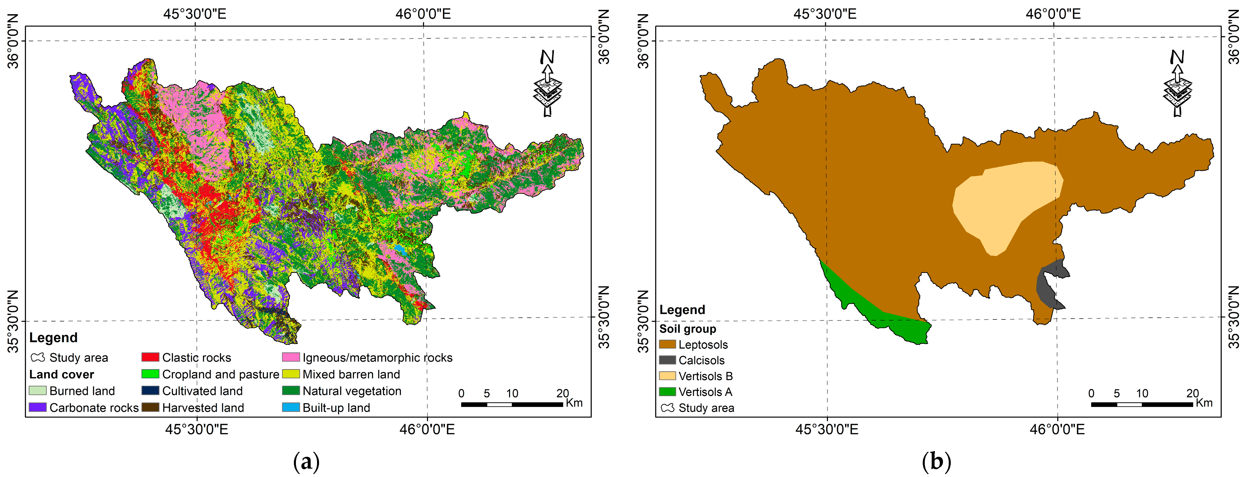
44]. According to the Food and Agriculture Organization (FAO), six influential factors were identified to categorize RH areas: topography, climate, hydrology, soil, agronomy, and socioeconomic criteria [
45,
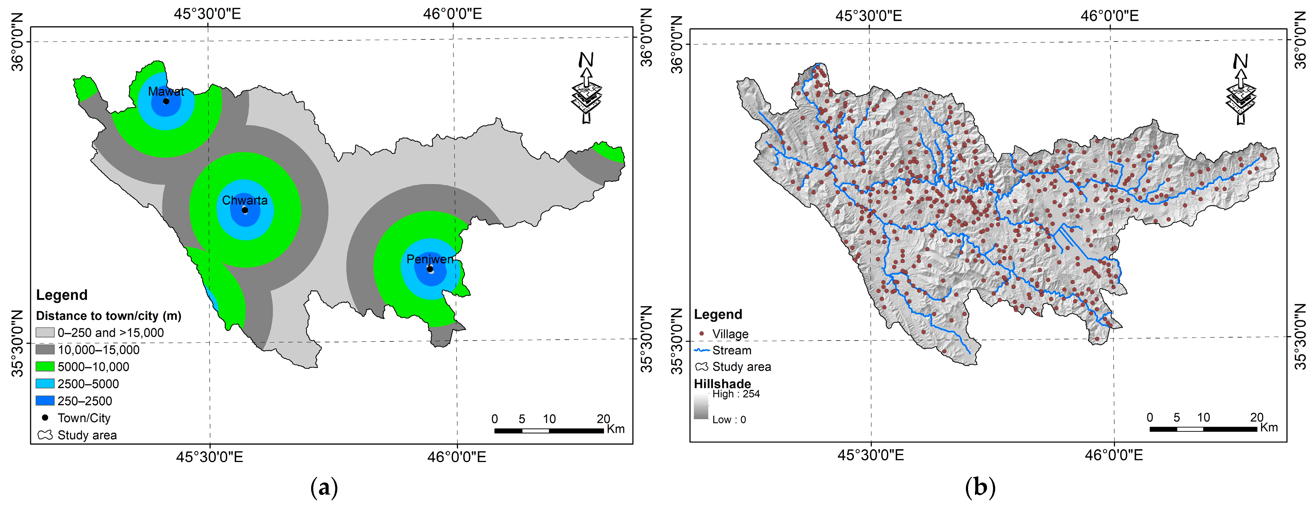
46]. The most prominent criteria used in the reviewed articles to determine suitable locations for RH and multipurpose dams, as a percentage, were: slope (100%), land use/land cover (82%), soil (77%), rainfall/precipitation (64%), roads (55%), runoff (50%), drainage density (41%), geology/lithology, faults, and settlements (36%), elevation as a thematic layer (32%), stream order and rivers (27%), villages (18%), discharge, lineaments, sediment yield, topographic wetness index, and wells (14%). The remaining criteria (e.g., geomorphology, distance to existing dams, hypsometry, cost, temperature, evaporation, and erosion) were cited in less than 10% of these publications.
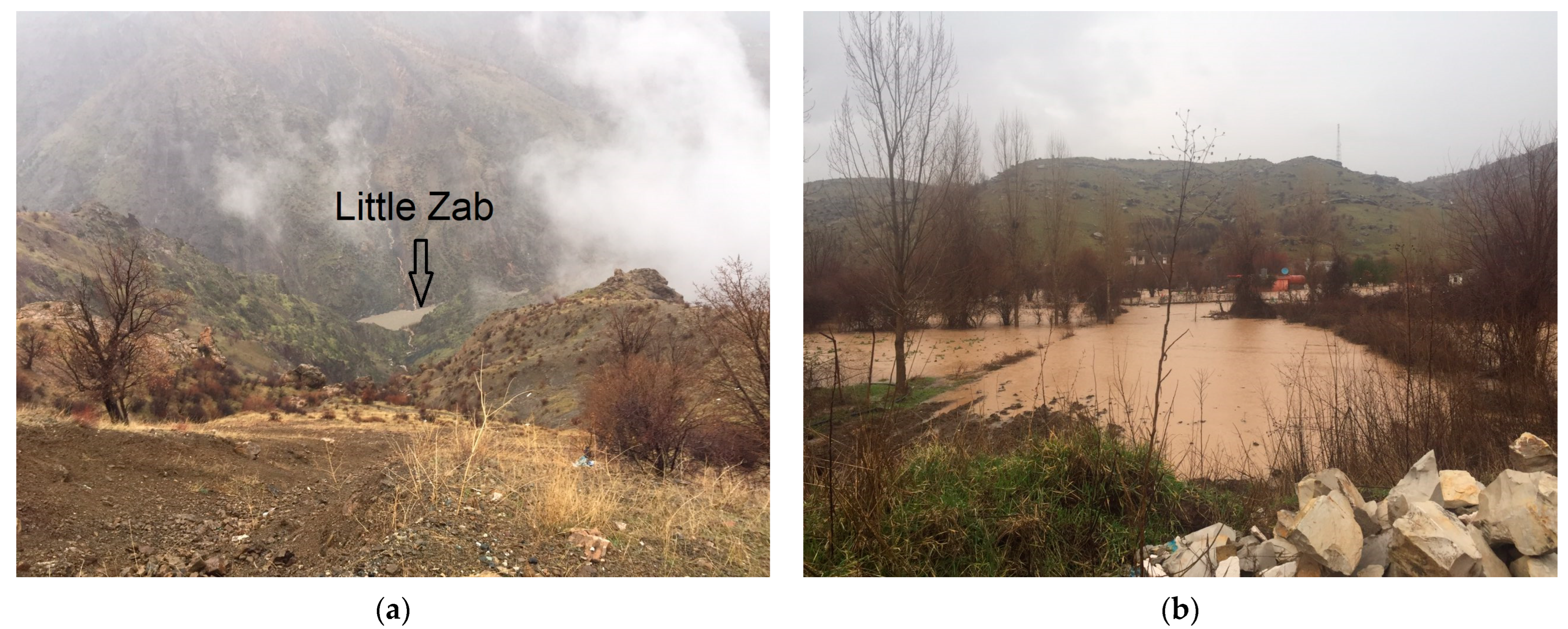
The torrential rainfall and subsequent floods of spring 2019 that hit Iraq and neighboring countries [
56,
59] raised water levels in the Tigris River and its tributaries (
Figure 1a). Consequently, water management features such as Dukan Reservoir (DR) reached its maximum safe storage capacity. In addition, the excessive flooding considerably damaged various agricultural fields and infrastructures and caused temporary human displacement (
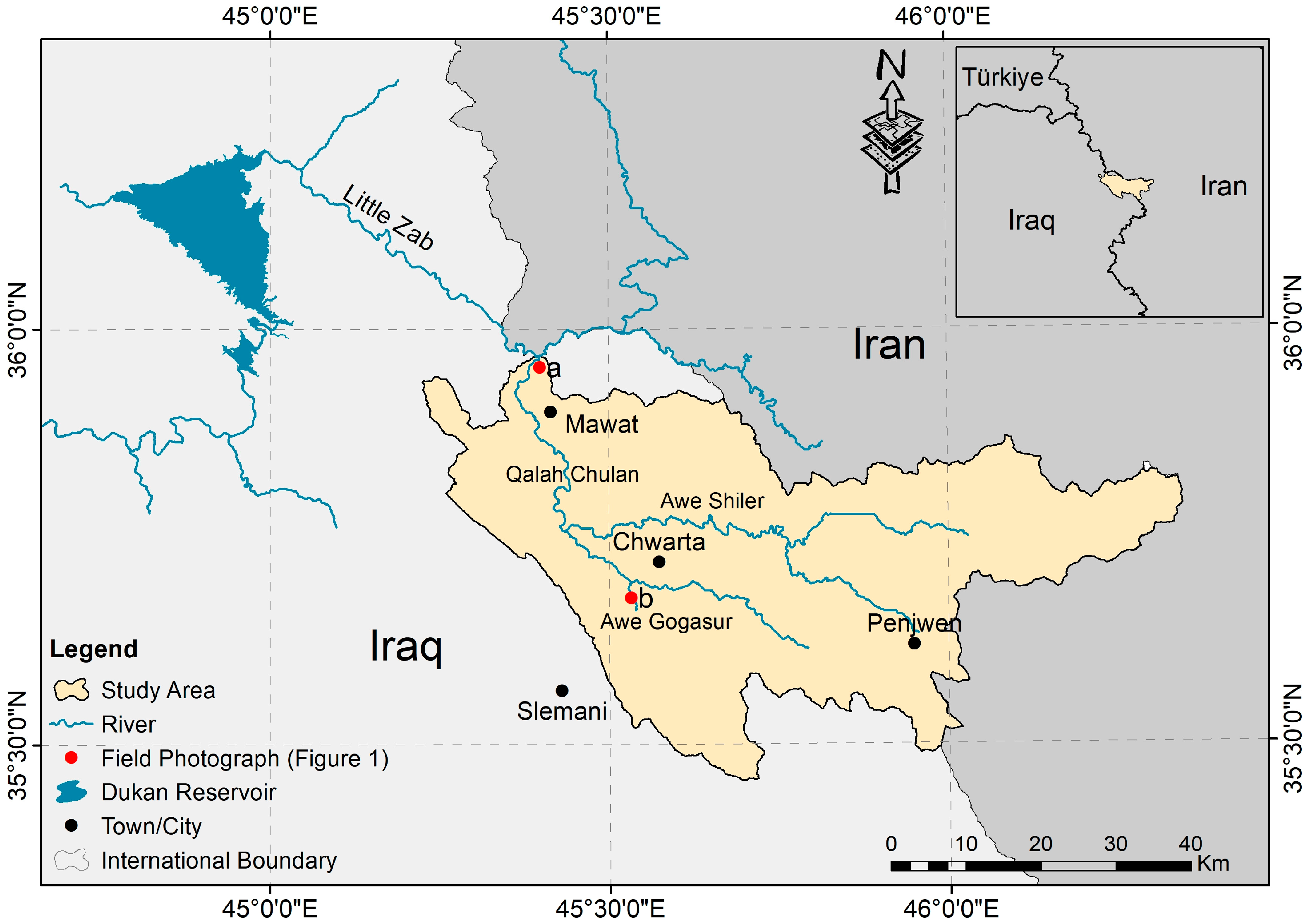
Figure 1b). These dramatic episodes inspired us to determine potential sites for RH and dam construction upstream of DR to prevent the adverse impacts of flood waters and secure aquatic demands for stable development in the Hami Qeshan Watershed (HQW), a mountainous catchment in the Iraqi Kurdistan Region (IKR) (
Figure 2). Hereafter, the objectives of this study are threefold: (1) to create RH suitability maps based on the WLC and AHP models, (2) to validate the results attained through 16 preselected dam locations, and (3) to propose optimal sites for constructing new dams in HQW (
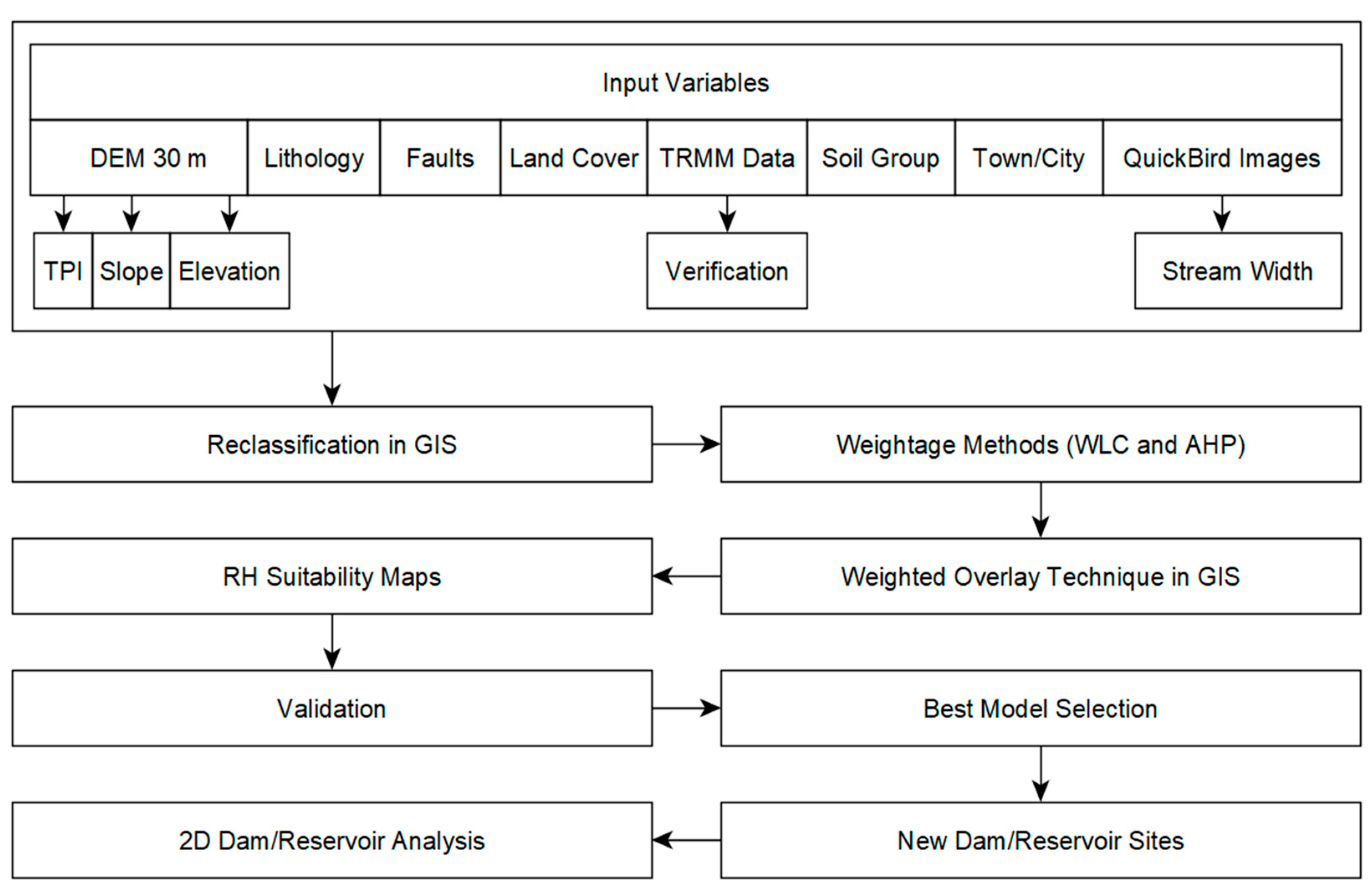
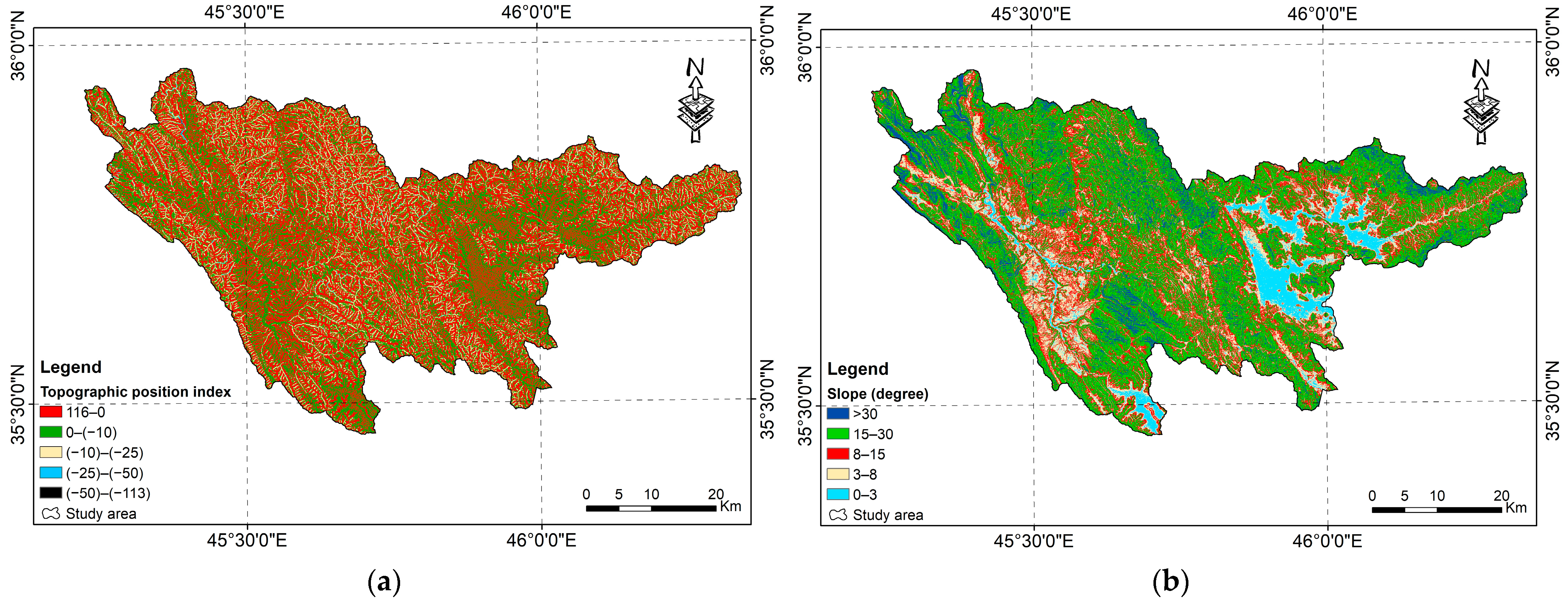
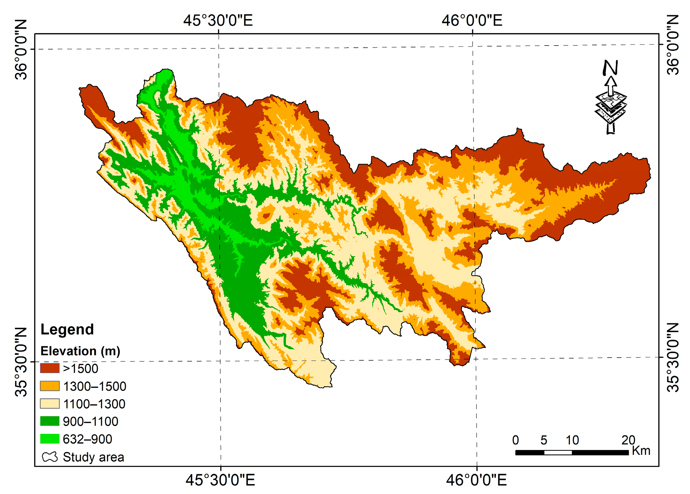
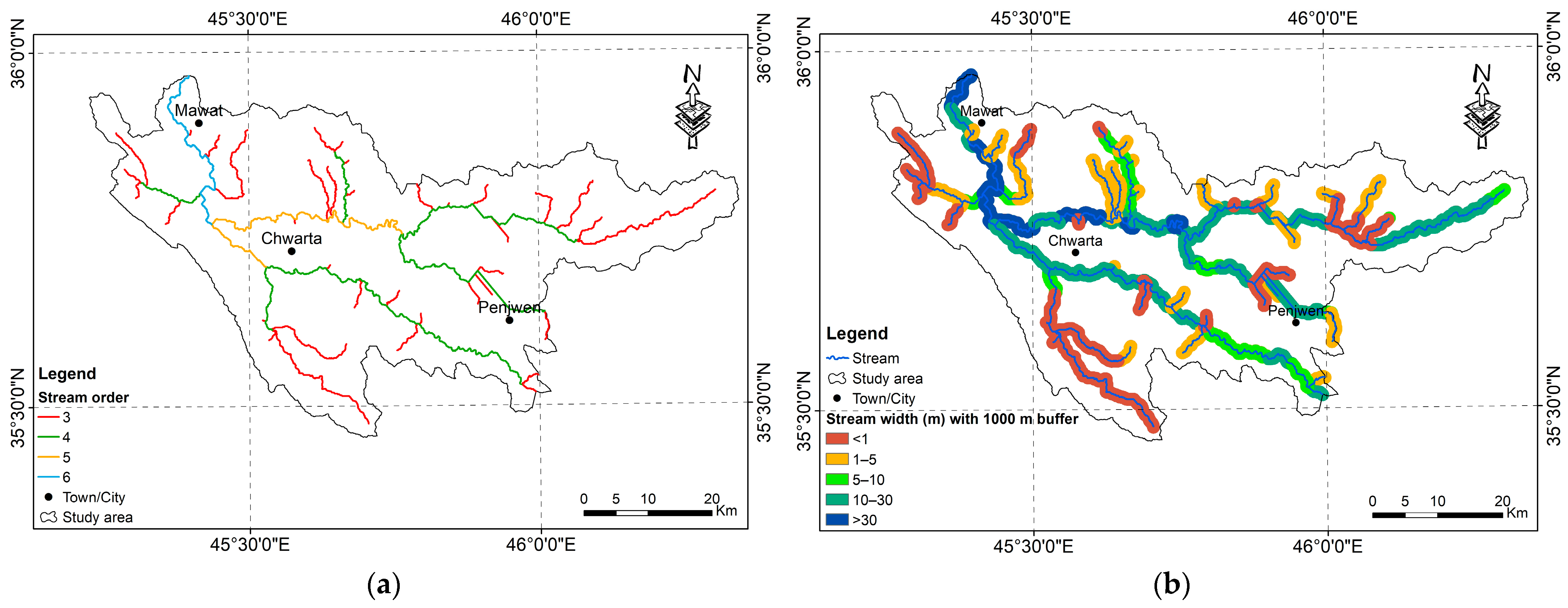
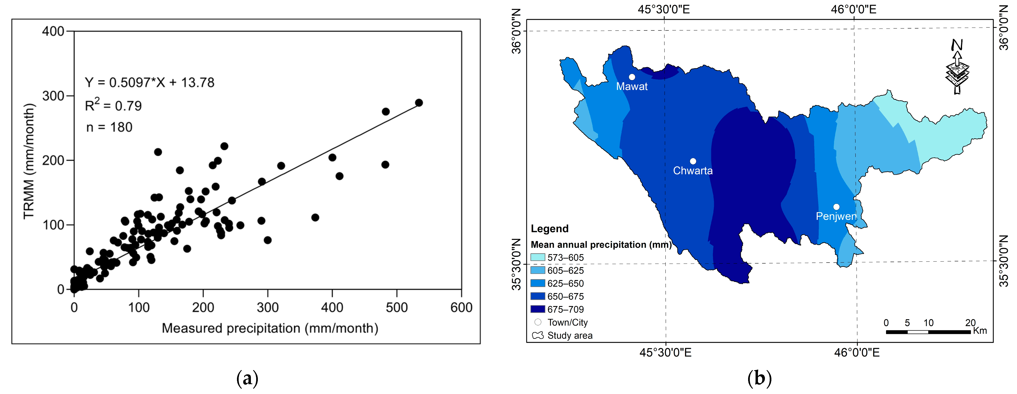
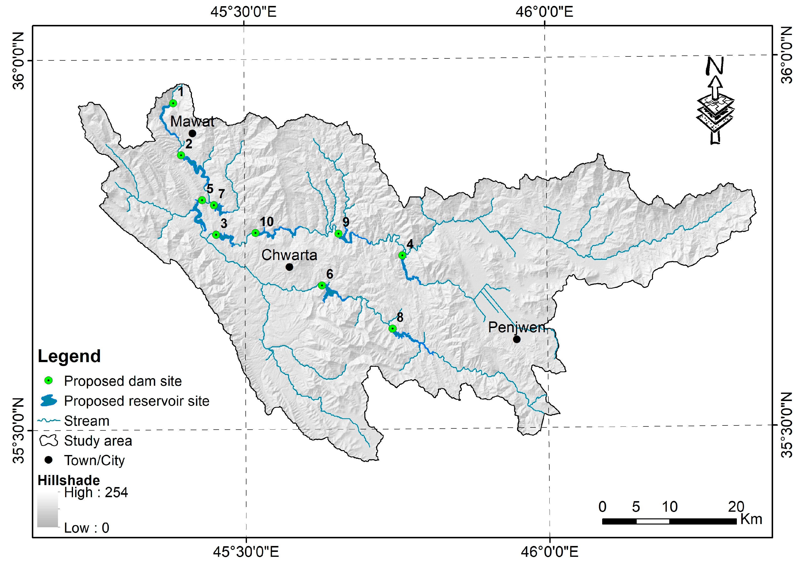
Figure 2). Ten evaluative criteria were implemented to generate the RH maps and assess optimum dam siting: topographic position index, lithology, slope, stream width, precipitation, soil group, land cover, elevation, distance to faults, and distance to town/city. Although HQW has important characteristics for sustainable development, no studies have investigated surface runoff harvesting and dam siting based on in situ data, RS images, MCDA, and GIS. Therefore, our findings are anticipated to fill a significant gap in the scientific literature on improving surface water management through dam/reservoir site selection and flood effects mitigation.
4. Discussion
Several studies have revealed that Iraq, including HQW, has undergone devastating floods and drought episodes in recent years [
10,
59,
115,
116,
117,
118]. However, despite receiving a substantial volume of precipitation, the surface water in HQW has not been adequately exploited due to a lack of runoff harvesting structures (e.g., dams), where most runoff waters are lost to drainage. Therefore, growing population and expansion schemes in areas susceptible to flooding necessitate a quick and effective response to alleviate overflow risks and guarantee water demands for dry periods. Within this framework, the current research applied the WLC and AHP approaches to generate two RH suitability maps for the Hami Qeshan Watershed and identify the best dam sites using ArcMap. The applied criteria/factors (i.e., TPI, LI, SW, SP, PCP, SG, EL, LC, DF, and DTC) for planning, implementing, and developing such techniques are described in
Section 2.5. Ultimately, the present methodology was validated with preselected dam locations that MAWR determined to efficiently manage the surface water in Kurdistan Region.
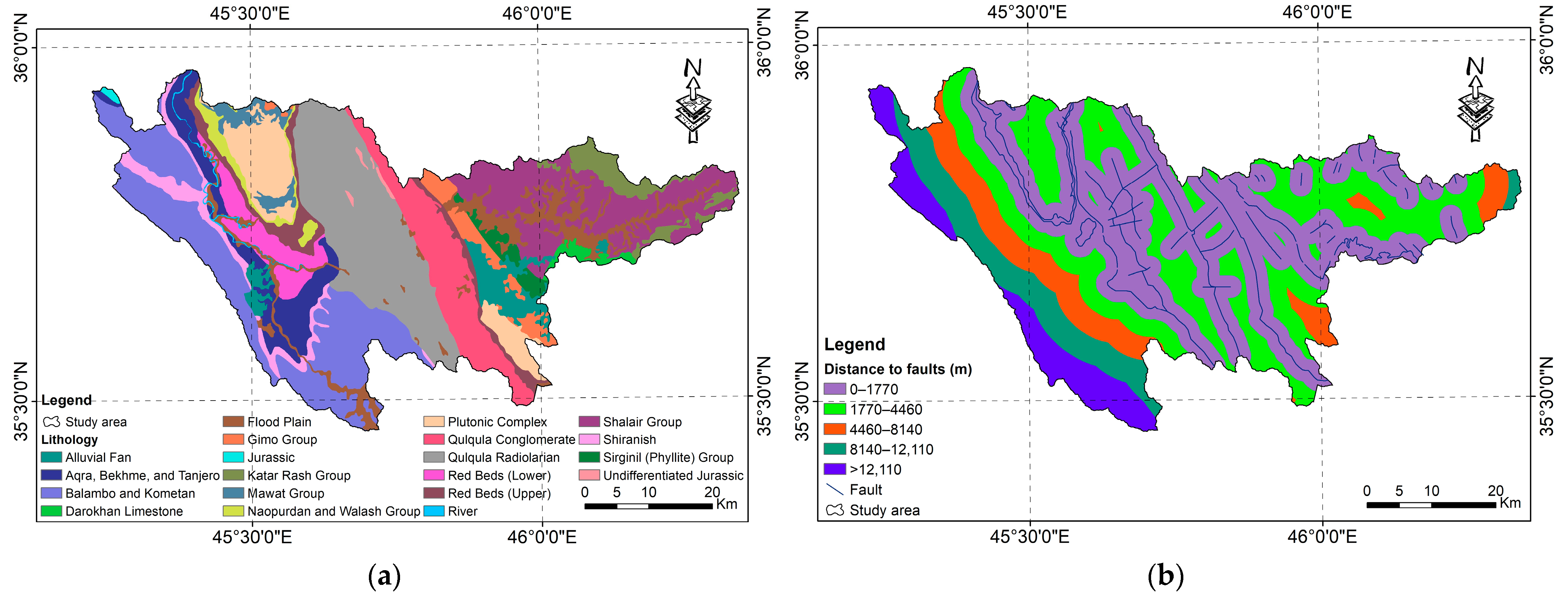
RH and dam siting through GIS techniques are laborious and challenging due to the involvement of multiple variables that govern the outcomes. Therefore, a comprehensive analysis of predictive criteria is indispensable to accurately evaluate the weights of factors under particular geographical circumstances. According to published studies, as mentioned in
Table 1, selecting dam sites requires considering several key factors such as slope, geology, streamflow, land cover, precipitation, soil, and socioeconomic concerns. Most earlier criteria were applied in regions with similar morphological, climatic, geological, and environmental characteristics, such as Duhok [
2] and Erbil [
31] governorates in northern Iraq. Few studies utilized TPI for dam site suitability assessment [
48,
56]; nonetheless, we assigned a significance weighting to this topographic criterion in which concave landform signifies ideal positions for surface water accumulation. The discharge of a river can be estimated by multiplying the water velocity by the average depth and width of the channel [
119]. Because HQW is an ungauged basin, we used stream width measurements as an alternative to streamflow data to strengthen the efficacy of the employed methodology. Othman [
4] reported that utilizing high-resolution satellite imagery (e.g., QuickBird) to measure stream width is a feasible mechanism to estimate streamflow for dam site selection. Furthermore, it outperforms other adopted criteria like stream density, which combines all drainages in a region irrespective of whether they are continual, seasonal, or dry outlets.
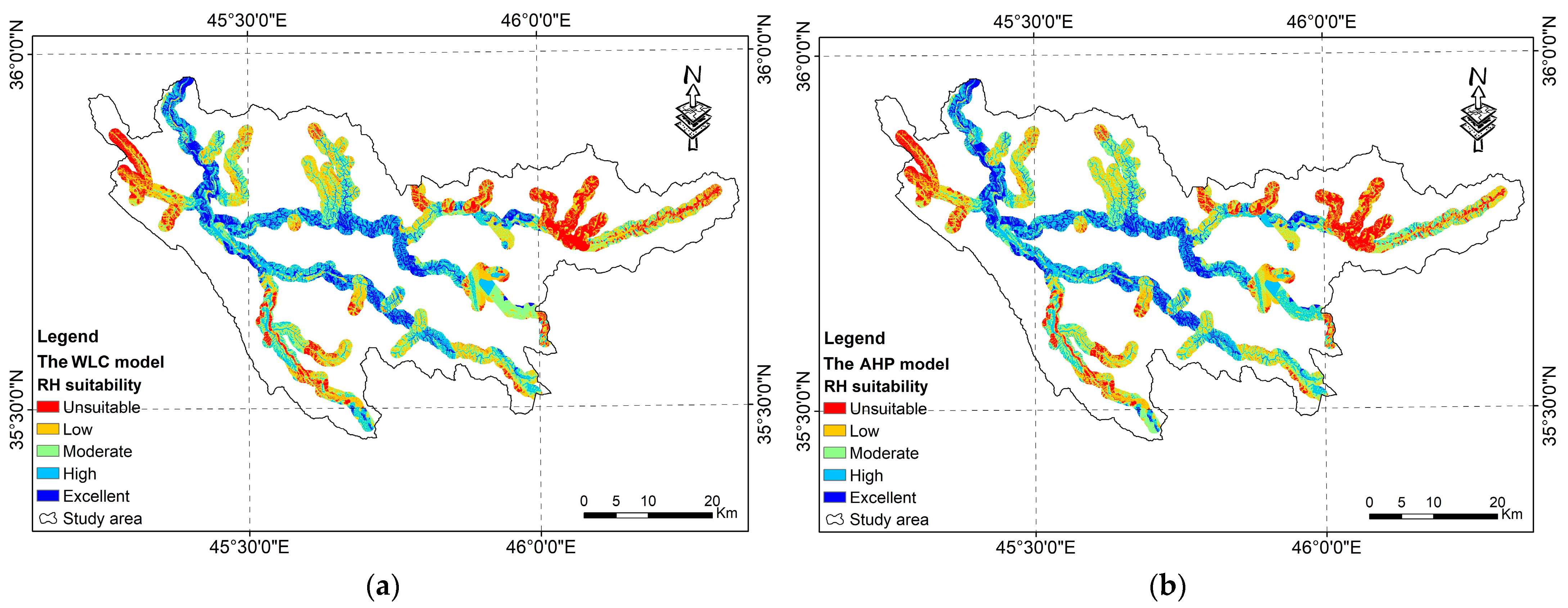
In this research, we created RH suitability maps for the mountainous Hami Qeshan Watershed using in situ data, RS imagery, and MCDA in ArcMap. The WLC model was employed herein due to its adaptability and effectiveness in merging the reclassified thematic layers and the normalized weights of factors to generate the RH map [
47]. At the same time, AHP was applied because it represents a powerful technique for solving and decomposing complex decision problems into pairwise comparisons [
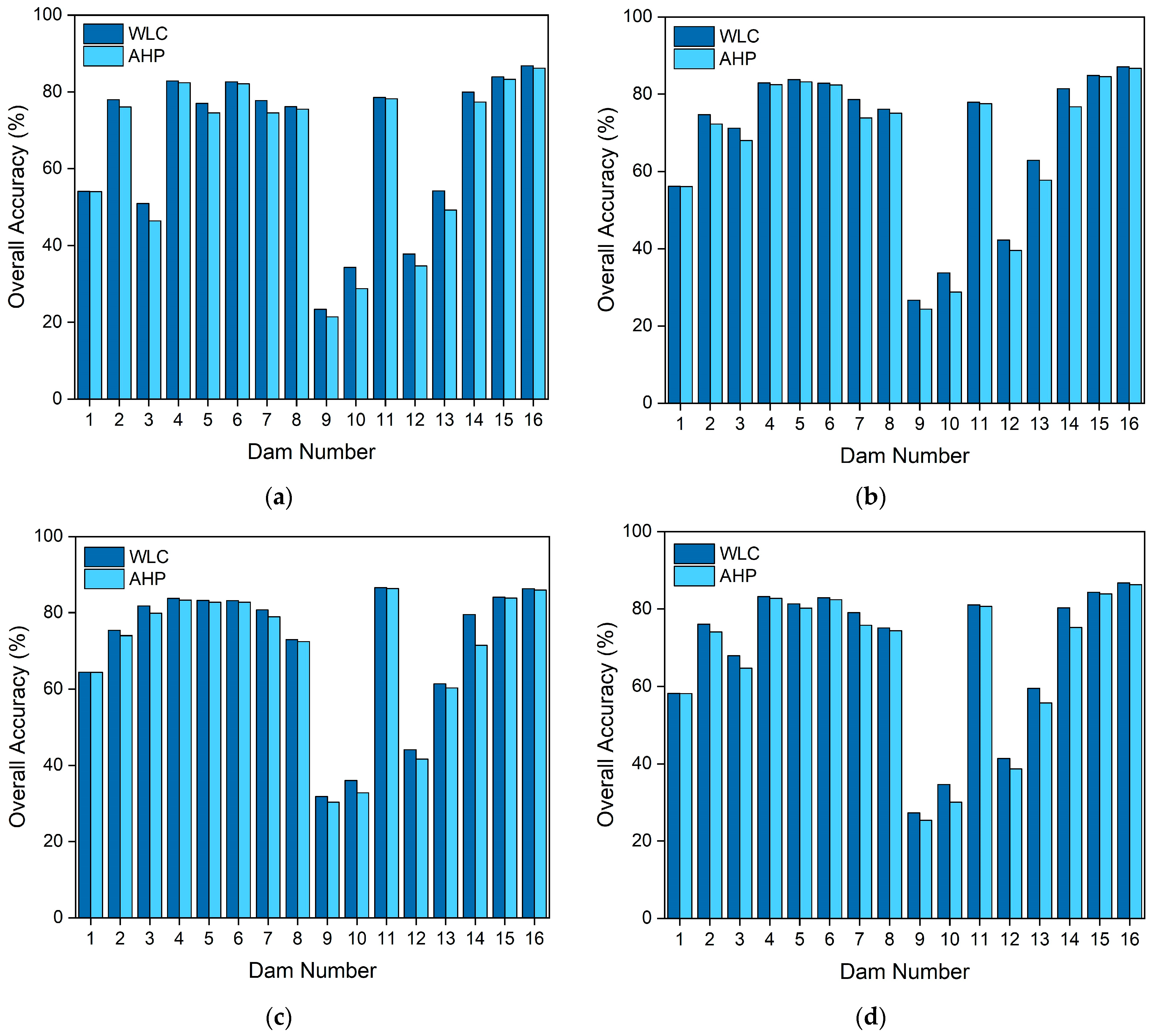
23]. Both models, WLC and AHP, were further assessed and validated via the SAA method (
Figure 11 and
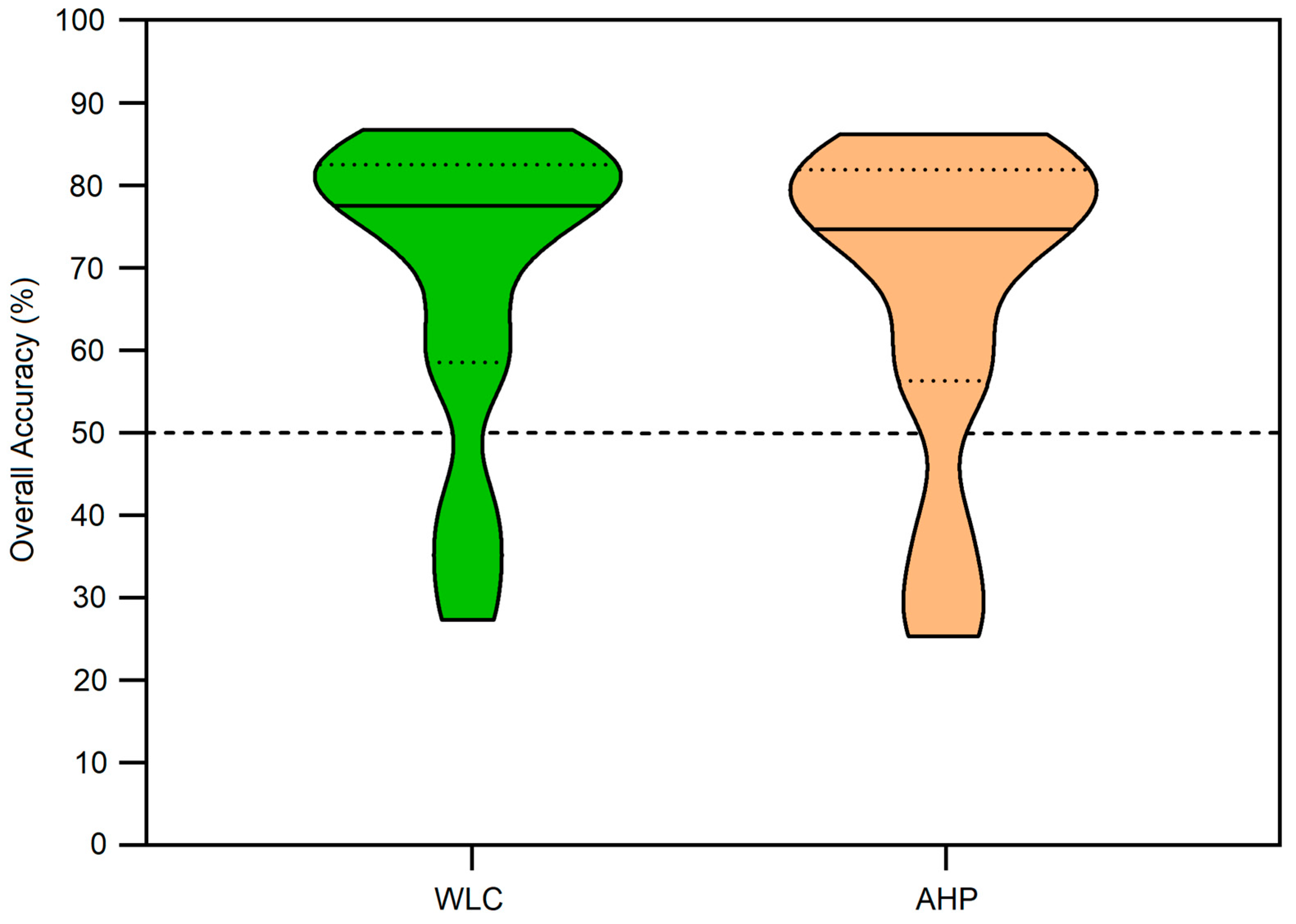
Figure 12). The truncated violin plot (
Figure 14) demonstrates that the WLC model achieved, to some extent, a better result than AHP. The correctness of the WLC approach is attested through the dispersion of its weighted criteria, which is above 75% of the overall accuracy (
Figure 14; green), as compared to that of AHP, whose percentage is fractionally below 75% (
Figure 14; beige). Thus, the current investigation selected WLC as the best model to spot probable sites for constructing new dams in HQW. Based on our literature review (
Table 1), most studies either applied the WLC approach as a primary and individual weighting methodology [
47] or considered WLC as an overlay technique in GIS [
2,
44]. In other words, according to our knowledge, no controlled studies have compared the two methods (i.e., WLC and AHP) as independent weightage schemes for mapping runoff harvesting zones. Consequently, the findings should meaningfully contribute to understanding the remarkable differences between WLC and AHP as two different weighting methods for site suitability determination.
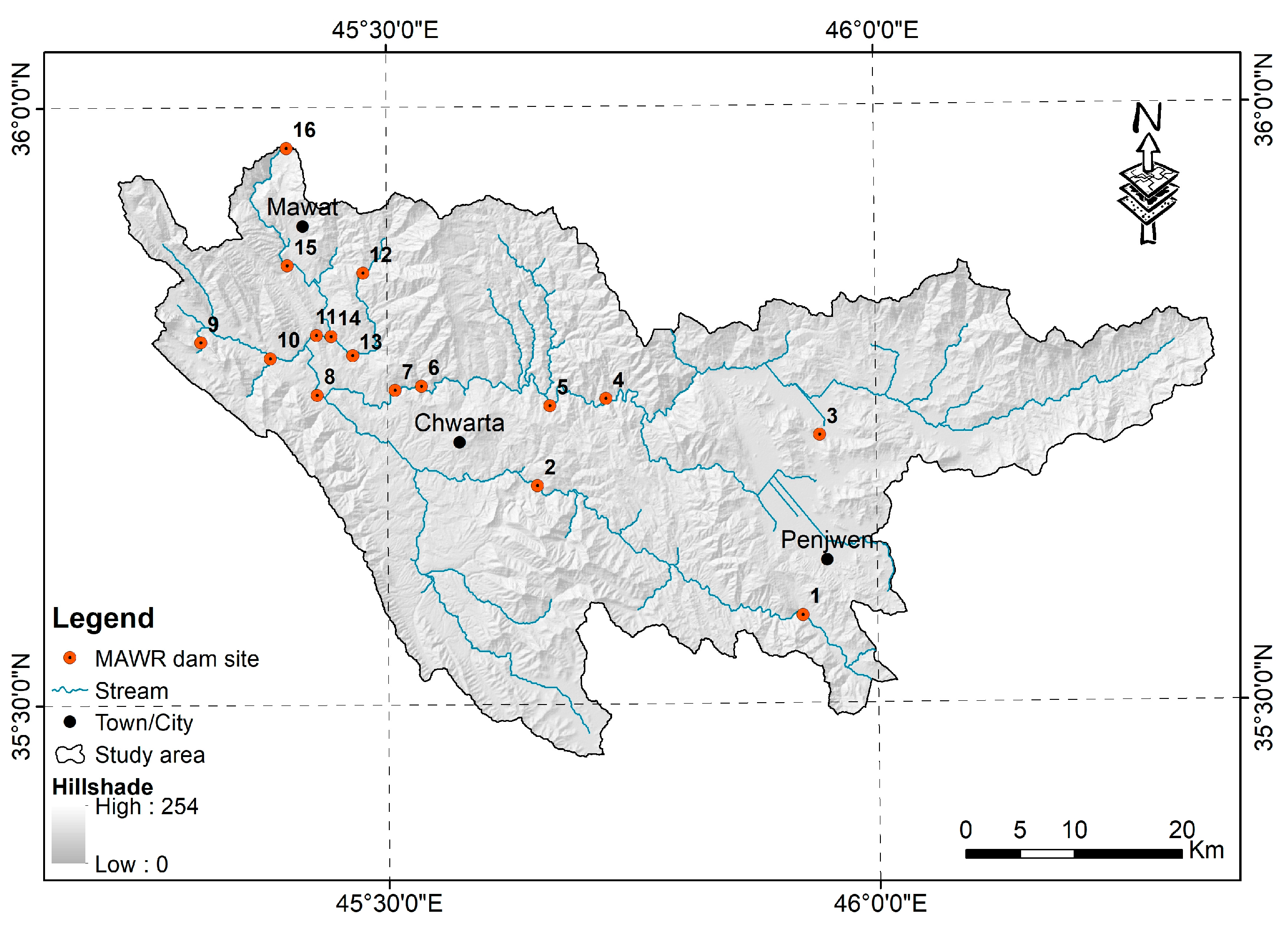
According to the adopted WLC model, 10 locations were distinguished as appropriate for dam construction in the Hami Qeshan Watershed (
Figure 13). Two of these sites (i.e., numbers 2 and 5), which are located northwest of HQW, are compatible with those preselected by MAWR (i.e., numbers 15 and 11). In addition, the overall accuracy of these ten scheduled dam locations in HQW ranges between 66% and 87%, as revealed in
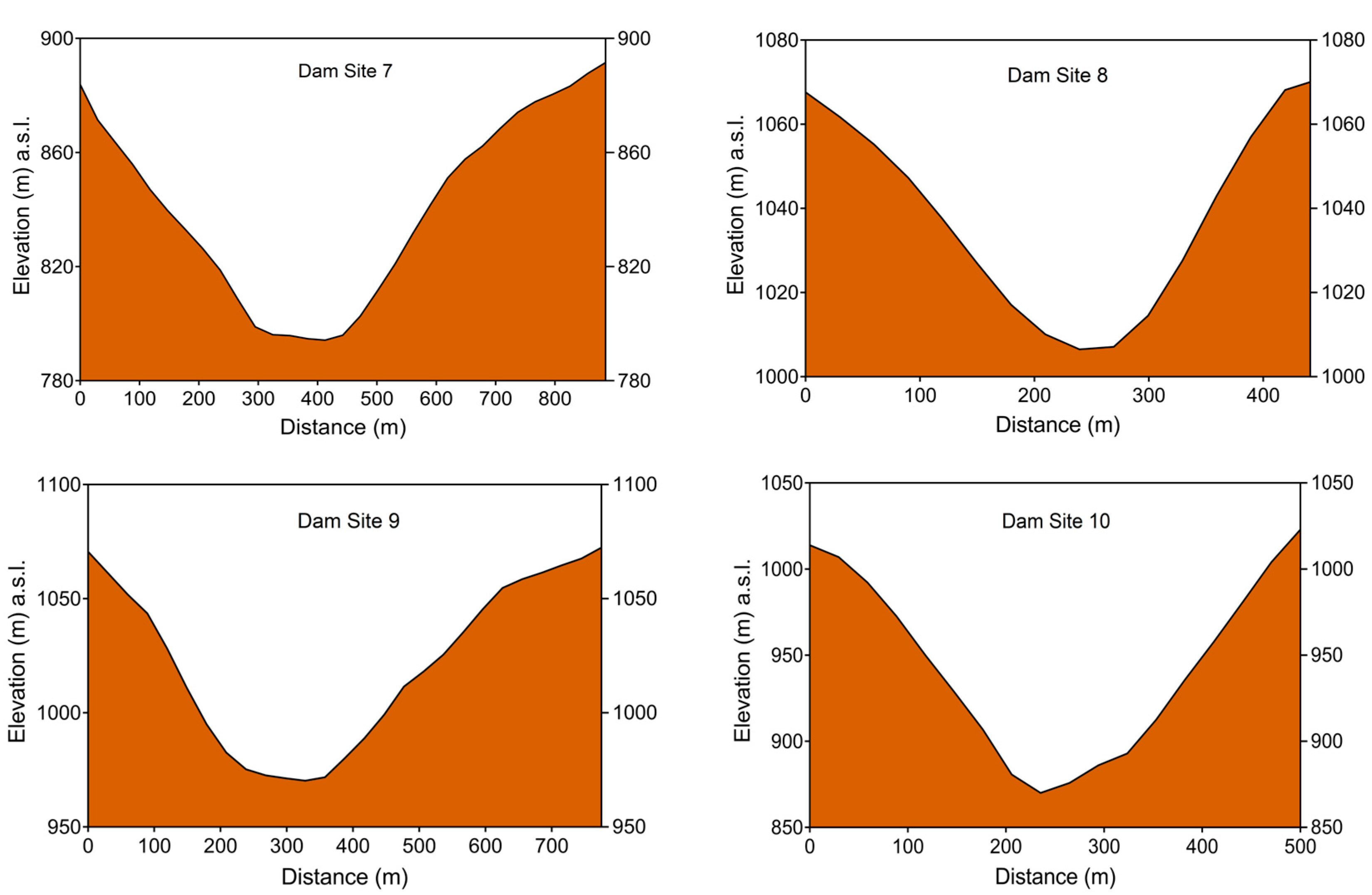
Table 7. Each potential dam position was additionally evaluated by analyzing relevant characteristics, such as dam profile, maximum dam height, crest length, and reservoir storage capacity (
Figure A2,
Table 6). The reservoir volume was calculated by multiplying the mean elevation of the water column at each pixel by the reservoir’s surface area. Concurrently, the dam profile (i.e., height and length) was determined using CDEM and ArcMap tools. It is worthy of mention that evaporation loss might be very substantial in this semi-arid region, where it increases as the surface area of the waterbody expands. Therefore, optimum reservoirs with minimum surface area and maximum storage capacity are preferred to mitigate water loss through evaporation [
11]. Ranking the proposed reservoirs in compliance with their maximum storage capacity, highest to lowest, puts them in the following order: 10, 6, 1, 2, 8, 4, 7, 9, 5, and 3 (
Table 6).
Based on
Figure 4 and
Table 6, some dam sites might not be feasible in practice due to their closeness to fault zones, namely locality numbers 4, 9, and 10. In contrast, the proposed dam number 1 can store a significant water quantity of 84,990,488 m
3, and its construction will not adversely impact adjoining villages. The 924 m length of this dam could be its only drawback, which would raise the construction cost compared to the other nine structures. Geologically, dam 1 is situated on vigorous rock units of ABT formations, and the nearest fault line is located 2.3 km eastwards. Even though dam number 2 can collect a high amount of surface runoff (i.e., 64,985,592 m
3), the large surface area of its potential reservoir (i.e., 3.09 km
2) might lead to a high evaporation rate. This site has advantageous lithologic and structural features similar to dam site 1. Another important location is number 6, which has the second-largest reservoir volume of 100,715,685 m
3 with a promising dam length (i.e., 523 m). Diverse and tolerable rock types of RBL, FP, and ABT crop out at site 6; nonetheless, the construction of dam number 6 will inundate minor settlements. Compared to the other sites, locations 7 and 8 could be categorized as intermediate reservoirs capable of holding runoff waters of 45,342,722 m
3 and 55,517,400 m
3 with a dam height of 88 m and 60 m, respectively. Water management features 3 and 5 have the lowest storage capacity of 25,636,552 m
3 and 33,801,950 m
3, respectively. In the future, strategic planners and policymakers could benefit enormously from this storage capacity evaluation of the recommended reservoirs at the designed dam sites. Such quantitative assessments will provide insight into the amount of water held in each reservoir with respect to the dam height. Consequently, it will assist in regulating water demand and supply for neighboring communities and imminent development.
Since MAWR dam sites are based on scanty field exploration and superficial GIS analysis that neglected vital aspects such as geology and streamflow [
4], our study was intended to consider all essential criteria (i.e.,
Section 2.2) for dam site selection through systematic MCDA approaches and ArcMap techniques. This investigation identifies optimal dam locations and their respective reservoirs that might further be considered for in-depth site assessments. Unlike sites with critical constraints, investing resources in more appropriate places could result in substantial expense savings. These multipurpose dams have constructive implications for HQW, such as flood protection, crop irrigation, hydropower generation, aquaculture, developing the granite and marble industry, expanding recreational activities, and securing water supply for the local communities. Correspondingly, the quality of life for locals and the environment around the proposed dams can be improved. As sedimentation constantly and adversely affects the capacity limit of reservoirs [
16], some of the proposed dams can be specified mainly to trap and prevent foreseeable sediments from entering Dukan Reservoir (
Figure 2), thus increasing its lifetime.
Nevertheless, the findings of this research should be cautiously interpreted as there are limitations that should be considered in upcoming studies. For instance, this study was limited by the lack of river discharge gauges on the HQW drainage network. The insufficiency and absence of accurate and continuous streamflow measurements could lead to an erroneous estimation of the actual surface water quantity. Also, a factor that was not addressed in this investigation was the electrical grid infrastructure at the potential dam sites, which is a critical aspect of developing a hydropower project [
120].
The adopted methodology, while preliminary, can be used as a scientific roadmap for a broader water management framework in mountainous regions. However, a detailed geological investigation of the recommended dam sites must be carried out before implementing any constructive action to shed light on the local geotechnical conditions and avoid potential failures [
121]. Interestingly, this mountainous region has geological evidence of landslide-induced dammed lake(s) during the Quaternary Period [
122], indicating mass-wasting hazards that could adversely affect the proposed dam/reservoir sites. Therefore, a supplementary study with more focus on landslides (i.e., frequency and magnitude) in HQW is suggested. As per global climate change, if the intensity and frequency of extreme events per year dramatically rise, it is crucial to develop flood susceptibility maps and scenarios for protective measures against disastrous phenomena. In future investigations, it might be possible to integrate the spatial optimization models recommended by Tong and Murray [
36] into dam site selection. Another probable area of future research would be to estimate the annual soil loss that negatively impacts the functionality and lifespan of the proposed dams [
70]. Decision-makers must also consider the additional greenhouse gases emitted due to dam construction that could result in human-induced climate change complications. Further research must be undertaken, which accounts for surface runoff volume generated within HQW. More studies can also compare the findings of the applied methodology with those of other approaches, such as machine learning [
29,
123,
124] and TOPSIS [
23], to strengthen the accuracy of the implemented model. All previous recommendations aim to improve the reliability and predictive capability of the proposed methodology and establish a practical framework for developing a sustainable and comprehensive water resource management scheme.
5. Conclusions
Even though surface runoff within a basin is one of the most crucial water resources, no previous researchers have attempted to determine optimal locations for harvesting this decent freshwater asset in the Hami Qeshan Watershed. In this study, we implemented an integrated methodology of in situ data, RS images, WLC, AHP, and GIS to determine feasible spots for harvesting surface runoff and constructing new multipurpose dams in the hilly HQW. The site assessment involved several vital factors, including geology, TPI, slope, precipitation, stream width, land cover, elevation, soil group, distance to faults, and distance to town/city. Attentively estimated criteria weights were assigned and evaluated for each MCDA method (i.e., WLC and AHP). After that, overlay analysis combined all the thematic layers into raster maps to provide the final RH suitability maps. The SAA method was used to validate the overall accuracy of the resulting maps based on 16 dam sites preselected by MAWR. The WLC model achieved, to a certain extent, higher overall accuracy than AHP. Consequently, based on the superior model (i.e., WLC), ten potential sites were identified for harvesting surface runoff and building new dams in HQW. The accuracy of these ten sites ranged between 66% and 87%.
Altogether, this study strengthens the idea that a thorough selection of the evaluative factors and their respective weights, which are far more critical than the employed methods, should be the main focus of future research. Despite the scarcity of on-site data, the current study provided insights into integrating satellite images, MCDA approaches, and GIS to delineate ideal RH areas and locate optimum dam sites in the ungauged HQW. Likewise, it is essential to note that the findings of the approach described herein can be continuously improved as the reliability of the data adopted increases. Developing countries like Iraq severely need such initiatives where large amounts of freshwater are drained during wet seasons, resulting in socioeconomic and environmental disasters. Although this research proposed ten runoff harvesting structures to control flooding and secure water supply, further studies are recommended to consider additional parameters, such as water quality, organic pollutants, and heavy metals within the relevant catchments. Ultimately, extensive fieldwork, including geophysical surveys and geotechnical investigations, must be conducted at the proposed dam sites before implementing any RH system.


