Abstract
This paper explores participatory design methods for the interconnection of digital recording techniques, like digital photogrammetry and Gaussian splatting, with emerging domains such as the metaverse and blockchain technology. The focus lies in community engagement and the economic growth of urban and rural areas through blockchain integration, utilizing low-cost digitalization methods to create Web3 environments mirroring real settlements. Through a case study of an Italian village, the potential of participatory design and community-led development strategies in revitalizing neglected areas are explored, and the use of low-cost drone-based photogrammetry and Gaussian splatting in digitization are compared, highlighting their advantages and drawbacks considering the aim of this work, i.e., the creation of an interactive metaverse space. Ultimately, the study underscores the transformative role of digital technologies in reshaping design processes and fostering community development through a workflow, stressing collaborative decision-making and blockchain-driven economy, manufacturing, and maintenance through self-ownership models and performance-based smart contracts.
1. Introduction
In this digital era, there is a growing demand for lifelike immersive virtual environments to create digital twins and metaverse experiences across various fields such as architecture, urban planning, construction, tourism, and entertainment [1]. Cities around the world are actively seeking to enhance their quality of living through community engagement, cultural preservation, and the introduction of smart city solutions [2]. Developing engaging websites to solicit important opinions and foster active discussion about current issues is proving to be crucial in this endeavor. Through this research, we explore various metaverse platforms, namely Mona and Voxels, to devise strategies for involving stakeholders in design decision-making. The proposed case study is focused on an alpine village, which was digitally reconstructed with image-based methods (photogrammetry) using drone images. Then, the resulting georeferenced model was exploited to set up an interactive metaverse space.
The fusion of geospatial data with the metaverse creates an exciting synergy that could revolutionize digital experiences across many sectors [3]. This goes beyond mere technological integration; it unlocks new dimensions of spatial computing and immersive interaction within virtual environments [4]. With geospatial-powered systems, users can seamlessly navigate virtual landscapes, uncover hidden spots, and collaborate effortlessly [5]. Envision a metaverse where users transition between virtual cityscapes, explore historical landmarks, or replicate environmental scenarios—all powered by geospatial data and GIS technologies [6]. This enhances realism and unlocks opportunities for applications across a wide range of domains.
The potential for cross-domain applications is equally compelling. For instance, architects can leverage GIS-enabled metaverse tools to visualize and refine building designs, simulating real-world terrain and environmental conditions. Archaeologists can digitally reconstruct ancient landscapes [7], creating immersive experiences and research simulations. Geospatial data enable metaverse platforms to incorporate real-time data streams like traffic updates, weather forecasts, or demographic insights. This combination enriches user experiences with timely and relevant information, spanning applications from urban planning to disaster response simulations and location-based marketing. Convergence is not just about generating virtual worlds; it is about constructing interconnected, intelligent, and immersive digital ecosystems that seamlessly blend the virtual and physical realms.
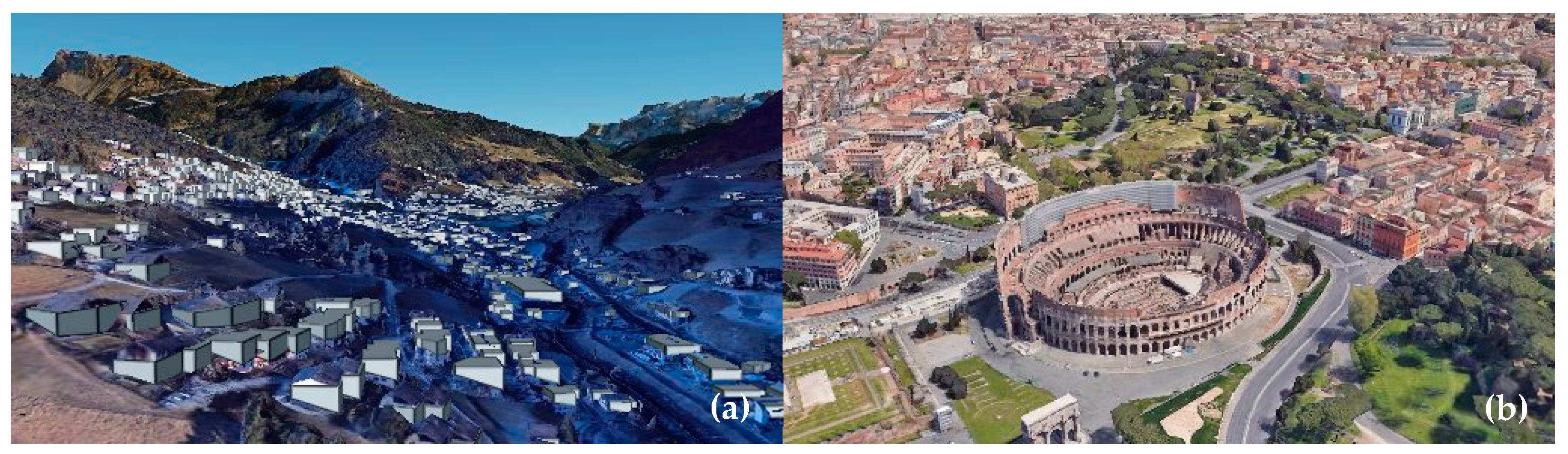
Some software solutions (i.e., 3D GIS-based visualization web-service platforms, including Cesium (version 1.116), ArcGIS City Engine (version 10.0.2), and Google Geospatial Creator) are already available to create these digital environments oriented to the metaverse. They have the advantages of robust interactivity, realistic visual presentation, and user-friendly interfaces [8], which play a significant role in urban resilience [9,10,11]. These platforms enhance geospatial information datasets but also present challenges in integrating diverse data within different systems [12]. At the same time, their constrained computational resources restrict both the scale of Earth data and the interactive functionalities of 3D visual models [13]. Since Cesium relies on external databases, the quality of the output varies. For instance, more detailed databases of 3D georeferenced data are available for urban areas compared to rural ones. For example, Ortisei-Val Gardena’s, renowned across Europe for its captivating Alpine vistas nestled within the Dolomite range [14], representation within Cesium data remains simplified, contrasting with the highly intricate 3D modeling evident in renowned urban centers like Rome (Figure 1).

Figure 1.
(a) OSM data for Ortisei; (b) photorealistic 3D tiles of Rome city in Cesium.
An alternative way for real-world digitization is to use photogrammetric models created from satellite images, aerial images, or terrestrial images [15]. More recently, alternative approaches, mainly oriented to visualization, such as NeRF (neural radiance field) and 3D Gaussian splatting, were proposed to offer immersive and realistic results that are already used in virtual reality (VR) and augmented reality (AR) applications [16,17].
Incorporating image-based reconstructions via computer-aided design software such as Blender (Version 4.0), Autodesk Maya (Version 2024.1), ZBrush (Version 1.0), or 3Ds Max (Version 2024) and artificial intelligence (AI) tools into the metaverse can provide a significant advancement that boosts virtual spaces’ realism, functionality, and practicality [18]. The fusion can empower metaverse platforms to construct virtual spaces that closely mimic real-world geography, allowing users to navigate lifelike landscapes, delve into realistic terrains, and engage with geographic elements.
Overview of the Proposed Method
The digitization process using photogrammetry to create a 3D model for immersive environments has been extensively studied for VR applications but not for metaverse platforms [19]. There is research on the design and development of sustainable Web3 spaces that focuses on decentralization, user experience, real-world integration, and a viable economy, yet does not consider the issue of bridging real life to virtual worlds [20]. Reimagining traditional engagement methods, a novel digital strategy for Web3 community transformation, linking photogrammetry, blockchain, and the metaverse, was proposed in a previous study [21]. This methodology envisions an approach where virtual environments created with digital recording tools serve as dynamic hubs for social interaction, economic activity, virtual tourism, and metaverse-based design processes [22]. It is important to acknowledge that in metaverse platforms, such as Decentraland, Sandbox, and Mona, regular visitors have limited abilities to create and publish scenes, engaging primarily with content from designers and parcel owners. Unlike multiplayer games, which focus on specific gameplay objectives, the metaverse offers a broader, persistent digital environment encompassing socialization, commerce, and content creation. Here, users enjoy greater agency and interconnectedness, shaping and influencing their virtual surroundings across diverse experiences and platforms while generating new economic value.
In the case of the neglected urban voids of Riga, participatory design in the metaverse was explored to empower communities and allow them to shape their environment actively [23]. Utilizing blockchain and the metaverse helps enable decentralized governance models and foster community participation in urban revitalization projects. Furthermore, the project showcases the potential of leveraging blockchain technology, smart contracts, and decentralized autonomous organizations (DAOs), enabling residents to exercise greater control and transparency over decision-making processes, funding allocation, and project execution within their neighborhoods.
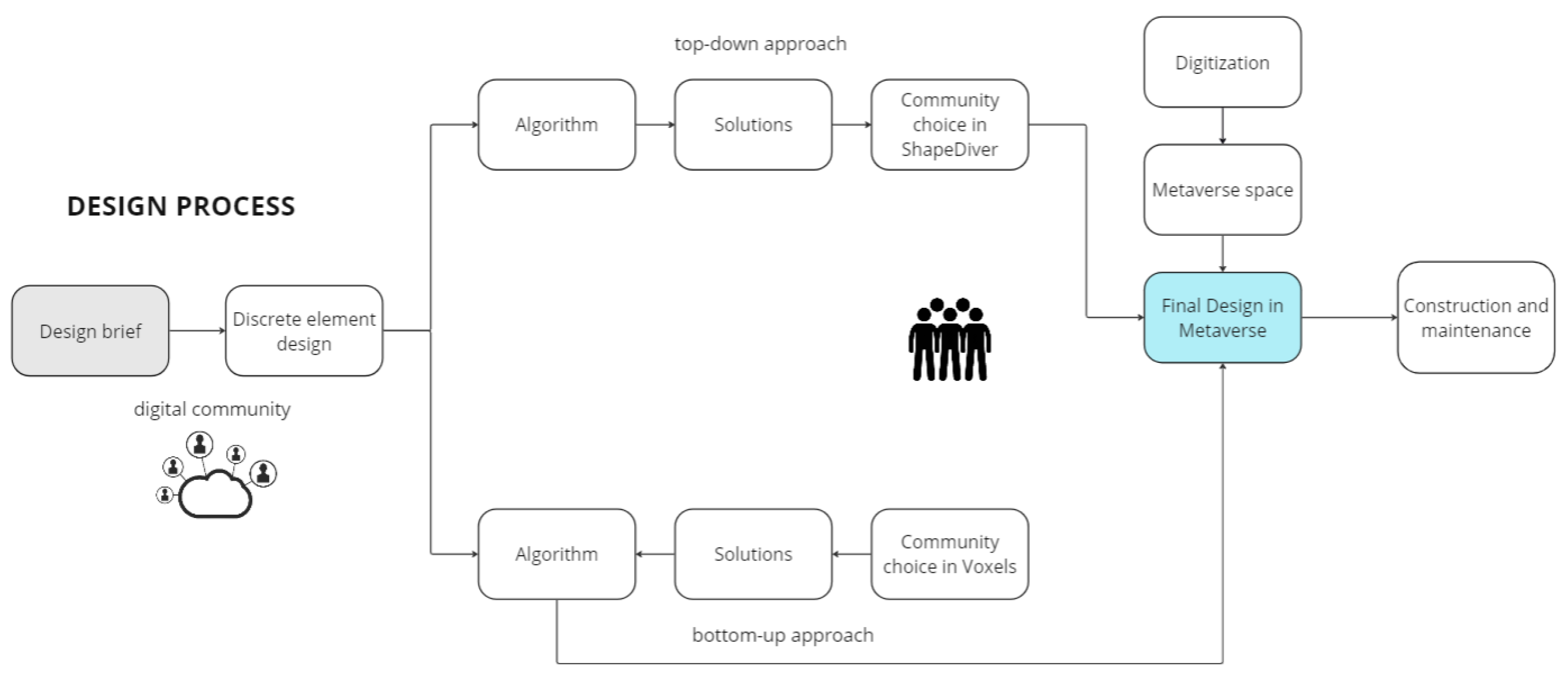
As a follow-up to the previous work [21], the current research delves critically into the significance of digitization and enhancing stakeholder participation in design processes. It explores various design methodologies, both virtual and real, to develop a metaverse-based workflow, distinguishing from the initial work and expanding the original concept. The system (Figure 2) consists of stakeholder involvement in three domains, namely, digital recording, metaverse space, and participatory design, and is managed using blockchain technologies. Exploring the potential of digital tools to facilitate inclusive and collaborative design processes in shaping the future of their built environment and fostering community revitalization.
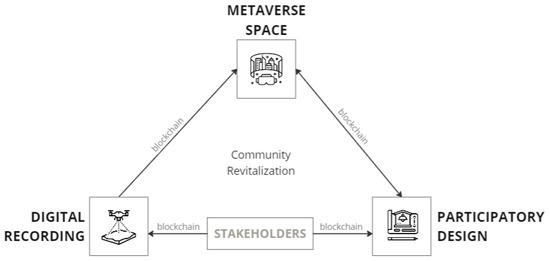
Figure 2.
Proposed digital strategy system connected through blockchain.
To further explain these domains, the digital recording of urban and rural scenes involves obtaining reliable information about physical objects, their spatial location and geometry, and the environment through recording digital images. The metaverse space is an evolved network of shared, immersive virtual worlds where people can connect with friends, create and play games, work, and shop. Participatory design is a way of placemaking in which the design attempts to actively involve all stakeholders in the process to help ensure the result meets their needs and is usable. It is focused on design processes and procedures. It is not a design style but rather a way of creating more responsive and appropriate environments for their inhabitants’ and users’ cultural, emotional, spiritual, and practical needs.
The objective of this paper is to establish a participatory design framework utilizing the metaverse. The target audience for this framework is the general public, who will have the opportunity to engage with designers in the process of observing, modifying, and validating the design. To envision a digital strategy and create a workflow to foster community development using these three domains, the entire paper has been divided into the following sections which are elaborated below:
- a.
- Stakeholder participation through the blockchain.
- b.
- Digitization from drone-based digital recording to the metaverse.
- c.
- Metaverse-based participatory design.
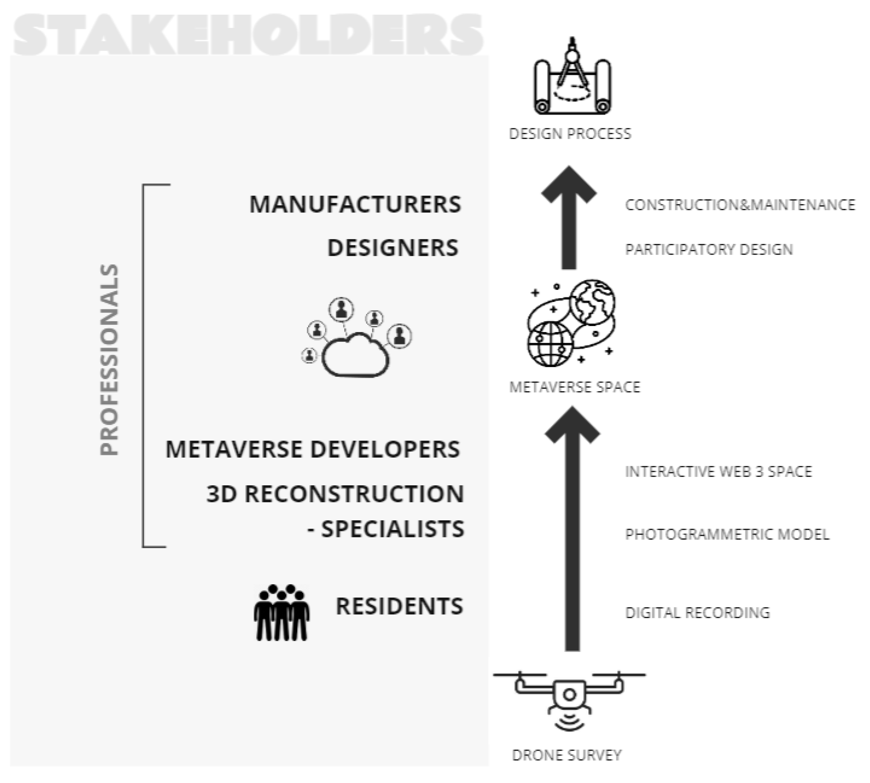
2. Stakeholder Participation through the Blockchain
With the motive of community development and a desire to address specific needs or capitalize on opportunities within the community, the digital strategy begins with understanding the needs and desires of the residents within a community to create its own metaverse space. The reasons vary widely and may include fostering social connections outside the community in an increasingly digital world, preserving and showcasing cultural heritage, creating economic opportunities through virtual tourism and commerce, enhancing educational opportunities, enabling creative expression, and empowering the community to shape its digital presence. In essence, the residents could serve as the driving force behind the creation of a metaverse space, as their motivations and aspirations shape the objectives and outcomes of the project.
The term ‘stakeholder’ refers to a person, group, or organization with a vested interest, or stake, in the decision-making and activities of a business, organization, or project and can influence its success [24]. In this research context, several stakeholders are involved in the proposed digital strategy (Figure 3). Starting from the residents of the community aspiring for development. Engaging digital community, comprising professionals interested in digital recording and the creation and development of a metaverse space for the project.

Figure 3.
Involved stakeholders and their role in the digital strategy.
Residents, who may not have any experience with digital recording, could use affordable technology like inexpensive drones to survey their surroundings. Alternatively, local surveying professionals could be involved in the process, thus eliminating the need to purchase equipment and learn how to operate the drone. Survey files are then passed on to 3D reconstruction specialists, who employ photogrammetric techniques to construct detailed models. Subsequently, skilled metaverse developers transform these models into immersive digital spaces, which serve diverse purposes, ranging from facilitating social interactions and educational activities to promoting virtual tourism and serving as decision-making platforms. Notably, the metaverse serves as an effective tool for participatory design processes, wherein community needs can be translated into architectural functional spaces.
Designers, guided by the design brief formulated by residents to address the needs of the community, leverage metaverse platforms to engage the community in the design process actively. Once finalized, the designs are forwarded to manufacturers for on-site assembly. By leveraging blockchain technology within the proposed digital strategy for creating a metaverse space, the development process is enhanced and economic opportunities and incentives for professionals are generated. Through tokenized rewards for contributions, stakeholders across various stages of the strategy, including residents participating in digital recording, 3D reconstruction specialists, metaverse developers, designers, and manufacturers, can receive tokens representing value within the metaverse ecosystem, exchangeable for goods, services, or fiat currency. Moreover, blockchain enables granting ownership rights and royalties to professionals over the digital assets they create or contribute to, ensuring fair compensation for their work, such as royalties for digital models or spaces utilized or monetized within the metaverse.
The inherent transparency and accountability of blockchain’s immutable ledger further reassures professionals regarding the fairness of reward distributions and the integrity of the design and development process. Additionally, residents and digital community professionals can actively participate in decentralized autonomous organizations (DAOs) within the metaverse ecosystem, collectively making decisions regarding development and governance, including resource allocation, project prioritization, and reward distribution. Digitization process contributors, residents conducting the drone survey or contracting a specialist, 3D reconstruction professionals, and metaverse developers can earn rewards in the form of digital assets certified by non-fungible tokens (NFT) in the created metaverse space, as well as ownership rights to it recorded on the blockchain. Design process stakeholders, including involved participants from the community, designers, and manufacturers, obtain their incentives in the metaverse, which are related to the design outcomes, e.g., ownership rights to the selected design proposals. Blockchain asset ownership entitles to monetary benefits generated by the metaverse space or design outcome, thus creating additional economic incentives for the strategy. Furthermore, smart contracts automate agreements and transactions, ensuring fair compensation based on predefined conditions and criteria, reducing the need for intermediaries, and minimizing disputes over payment and ownership rights. Contributors of the process rely on a digital identity on the blockchain to receive digital assets as a form of payment. Through these mechanisms, blockchain not only streamlines both the digitization and design processes but also fosters a thriving ecosystem where professionals are incentivized to contribute their expertise and creativity. This Web3 environment generated economy will be the basis of the community resilience.
In this study, simulation was utilized to engage stakeholders across different stages of the research process, particularly during the digitization and design phases. Simulation, also known as role-playing, involved researchers assuming the roles of stakeholders to contribute to the development and analysis of the research. Additionally, participatory workshops were conducted both in real-life settings and on a metaverse platform to simulate interactions and gather feedback. Specifically, high school students from Lecco (in Italy), with no prior knowledge of design, were invited to simulate the roles of community members within the chosen community. Furthermore, invited participants, representing a diverse range of backgrounds, including some with prior knowledge of design and others with limited or no experience in the field, were invited to engage with the created metaverse space and represent residents of the village. This simulation-based approach facilitated a comprehensive examination of the research objectives and outcomes, providing valuable insights into the dynamics of stakeholder engagement and participatory design processes.
To test the proposed workflow, the Italian village of Ostana was chosen as an exemplary community that struggles with depopulation. The integration of photogrammetry, metaverse, and blockchain technologies was intended to revitalize the settlement and generate a new economy.
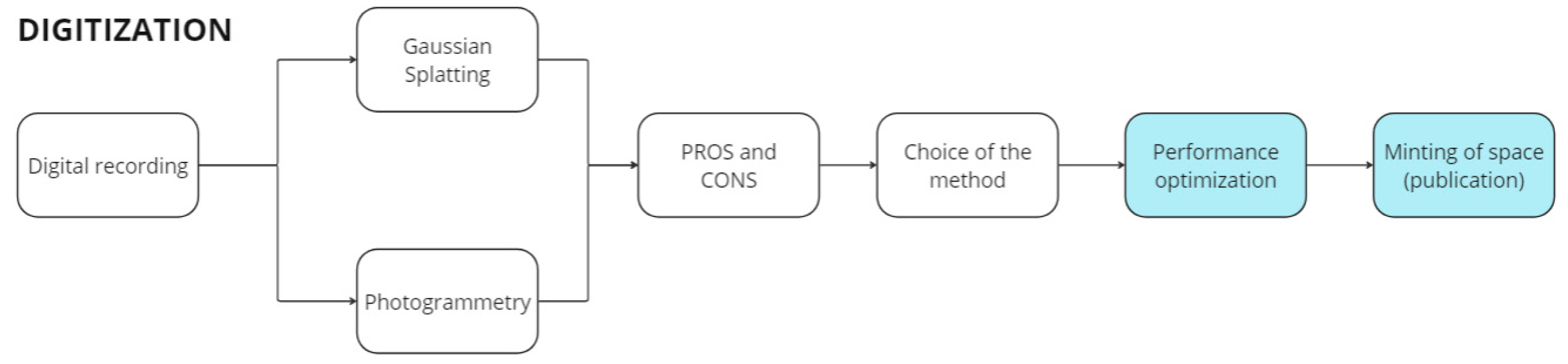
3. Digitization: From Drone-Based Digital Recording to the Metaverse
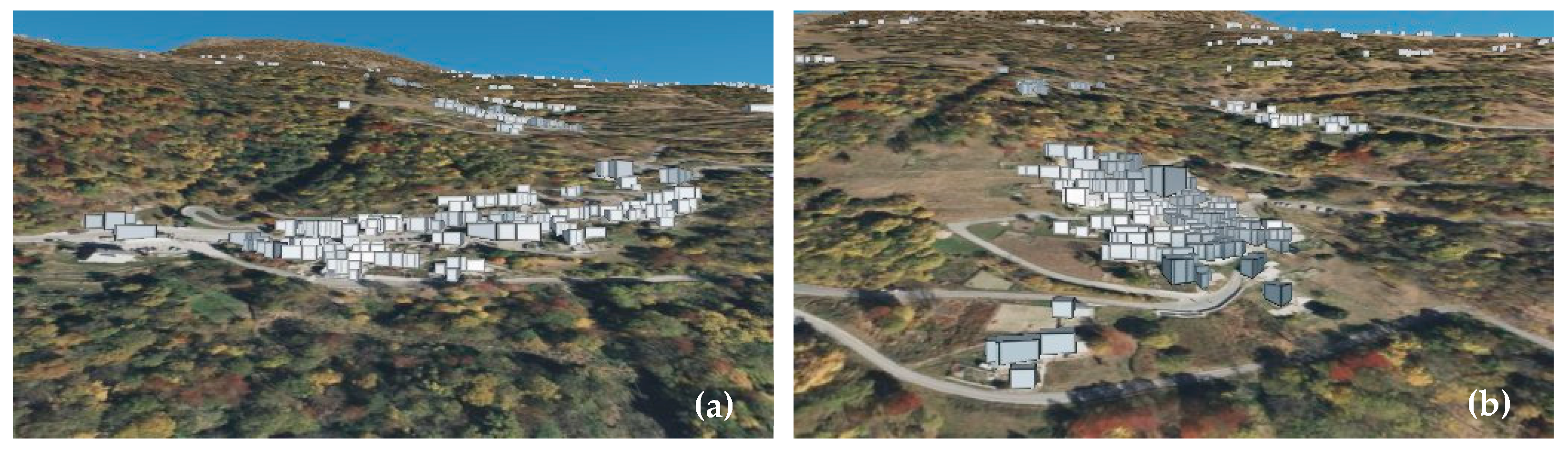
The metaverse is a web-based application that allows users to explore and experience virtual 3D spaces. The primary goal of the digitization process is to create an immersive, lifelike virtual environment using low-cost equipment and techniques that even non-professional users can perform without compromising output quality. Since the chosen case study is a remote alpine village (Ostana), which lacks existing databases to generate 3D models on platforms like Cesium, ArcGIS, etc., databases could not be used (Figure 4). Hence, the research relied on on-site acquisition of high-resolution data (drone images) to obtain a model that reflected the conditions of the site. This model was edited and uploaded to a metaverse space and could be further utilized for virtual community engagement, including education, sustainable tourism, and decision-making. Therefore, the performance and quality of the 3D model plays a crucial role.

Figure 4.
(a) OSM data for Villa, Ostana in Cesium; (b) San Antonio, Ostana in Cesium.
Drone-based reality capture was chosen to achieve cost-effectiveness and usability for non-professional users. The digitization workflow is shown in Figure 5. Inexpensive drones such as DJI Air 2s and DJI Mini drones were utilized to map two settlements in Ostana, a village in the Piedmontese Alps: Villa and Sant’Antonio. The drone images to create these models were processed via both photogrammetry and Gaussian splatting, and the results from the same are discussed and compared below for the purpose of this research. Subsequently, Web3 environments of the same were created based on these models on the Mona metaverse platform. Among other metaverse platforms focusing on immersive photorealistic worlds, such as Decentraland, Somnium Space, and Second Life, the chosen platform, Mona, prevailed in terms of accessibility and cost-effectiveness. Provided tools for metaverse developers allowed for more flexibility and user-friendly experience and the minting price (uploading the space) was significantly lower.
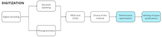
Figure 5.
Digitization workflow.
3.1. Digital Photogrammetry for Reality-Based 3D Modeling and Metaverse Creation
Digital photogrammetry enables the creation of precise 3D models by utilizing a series of digital images with suitable geometry for accurate reconstructions. The photogrammetric workflow involves extracting and matching tie points, followed by bundle adjustment (photogrammetric triangulation) to derive exterior orientation parameters. The images captured with the DJI Air 2s and DJI Mini 2 drones come with associated geographic coordinates (latitude, longitude, and elevation) measured via onboard GPS, albeit with relatively low metric accuracy. Due to the limitations of the low-cost drone used in this project, differential techniques for precise GNSS measurements were not feasible. Consequently, the rigid 7-parameter transformation (rotation, translation, scale) estimated post-bundle adjustment yielded RMSE values on camera poses at a meter-level accuracy at best. Therefore, the overall metric accuracy cannot be conclusively determined with the available data, and the authors acknowledge a potential bias in the model.
However, for the purposes of this work, the model only requires approximate georeferencing, as it will be imported into the metaverse space, which utilizes a local coordinate system. To achieve this, a conversion from geographic coordinates (latitude, longitude, and elevation) to cartographic coordinates (east, north, and elevation) was performed, selecting the UTM zone 32 North.
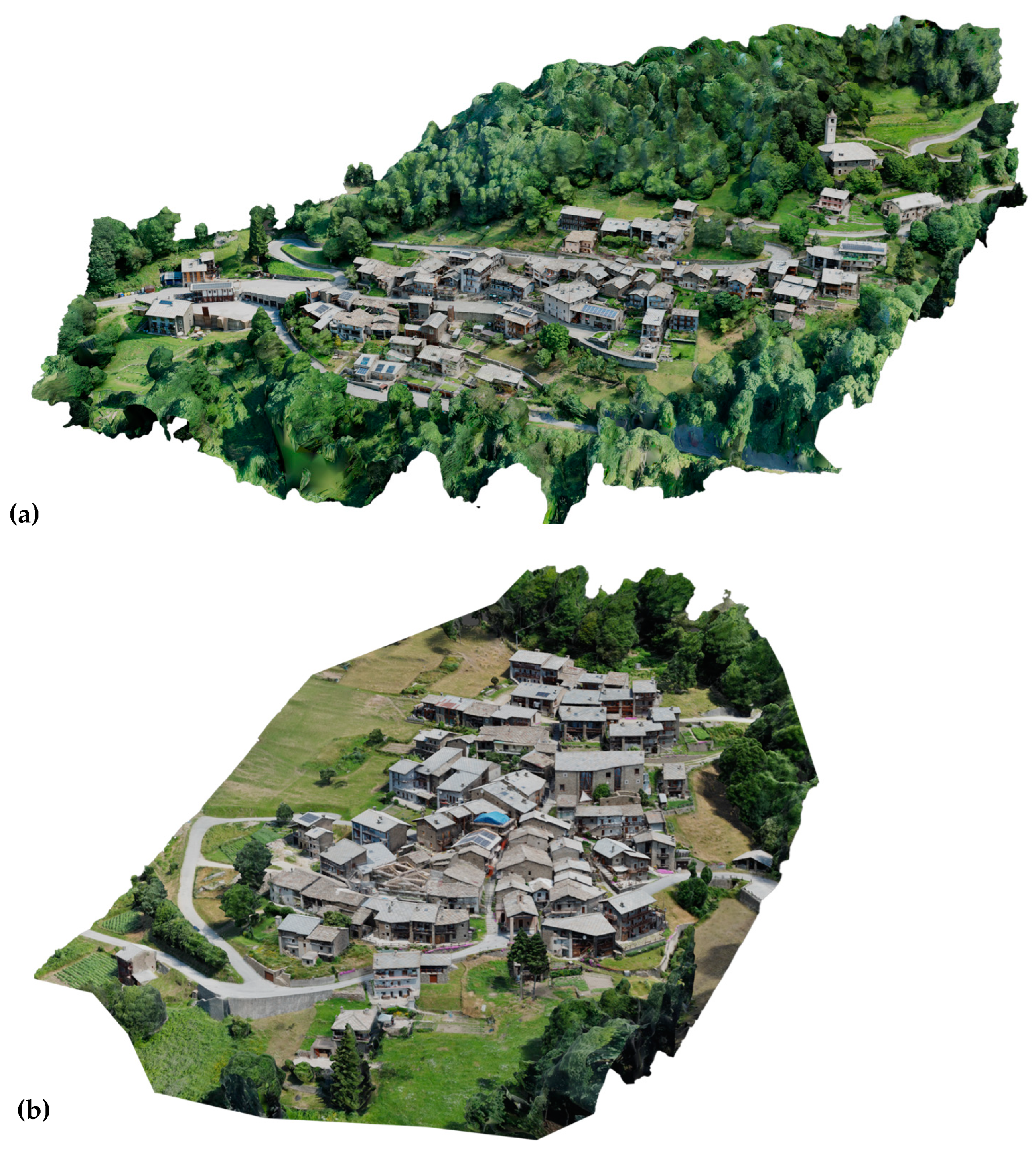
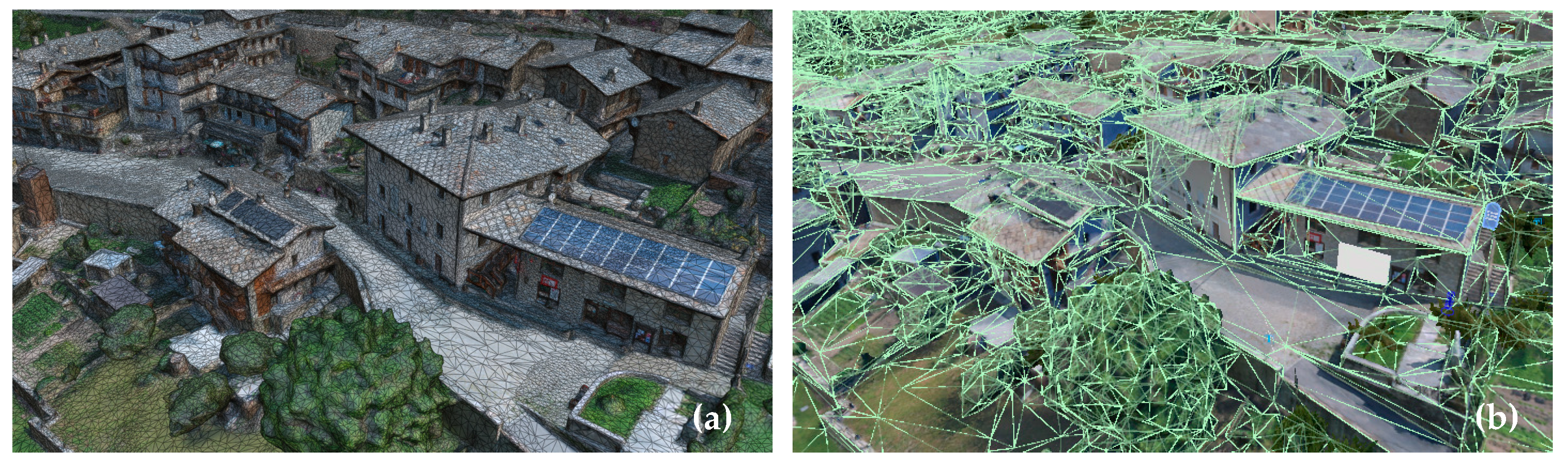
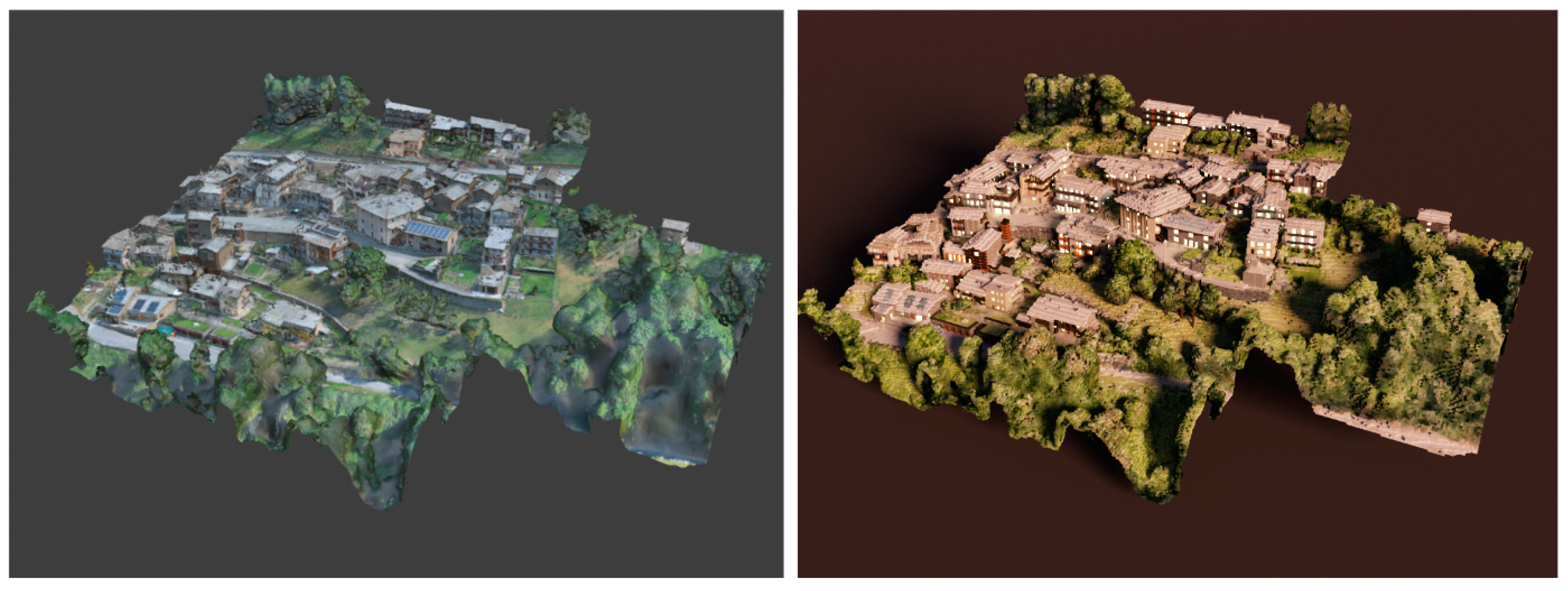
For the village of Ostana, a total of 2632 photos were captured with the DJI Air 2s and 2570 with the DJI Mini 2. Two recording campaigns were conducted over two days, during which low-quality images were excluded following visual inspection. Ultimately, 1774 images were used for Villa, and 591 for Sant’Antonio. Continuing with photogrammetric processing, a textured mesh was generated using image matching algorithms for surface reconstructions (Figure 6). The output is a triangular mesh saved as an OBJ file, accompanied by a texture file. Agisoft Metashape (Version 2.1.0) was employed as the photogrammetric software for the image processing. A single large texture file was exported to facilitate editing of the mesh and its texture.

Figure 6.
(a) Photogrammetric model of Villa; (b) photogrammetric model of Sant’Antonio.
3.2. Digital Reconstrction Using 3D Gaussian Splatting
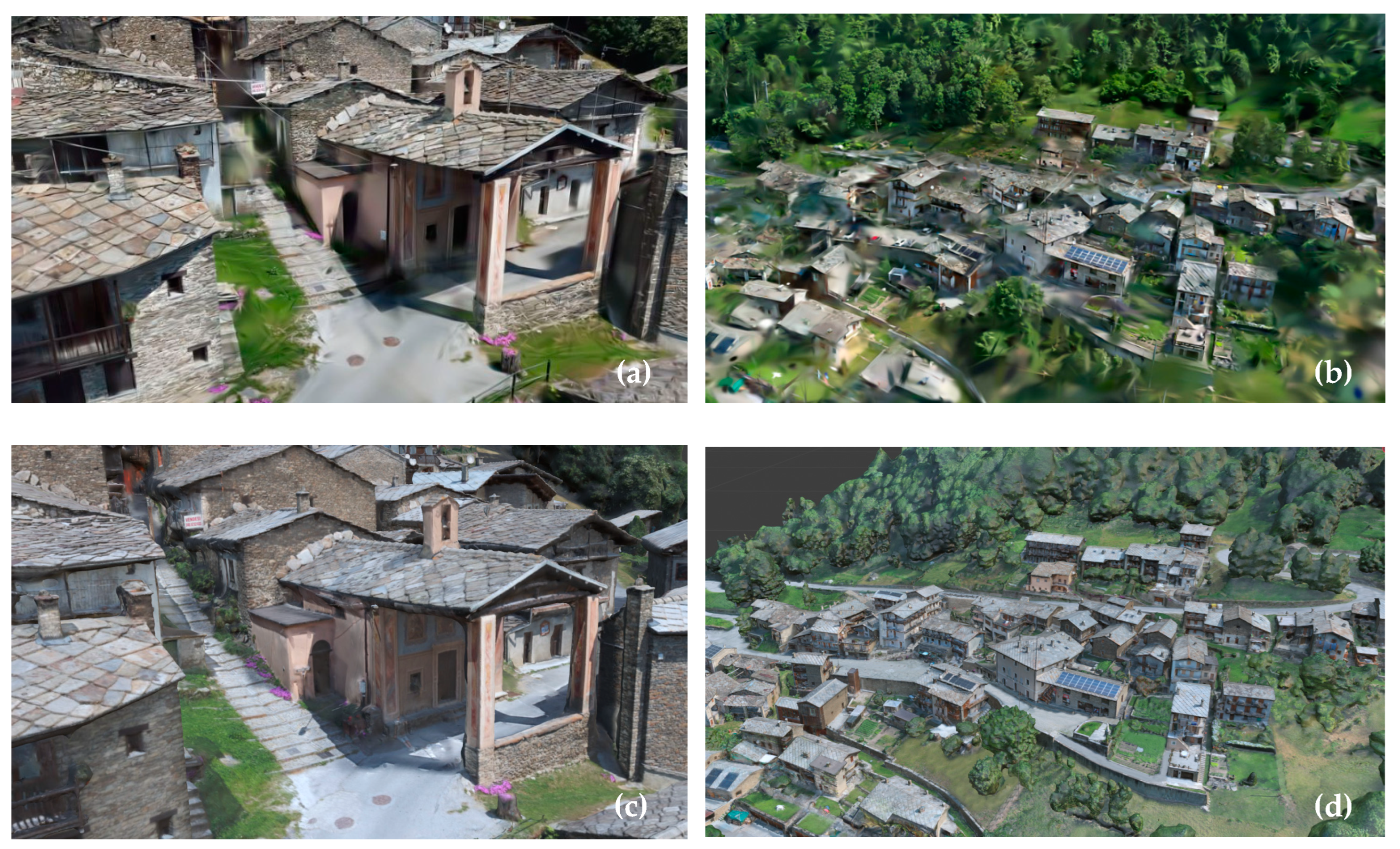
An alternative to conventional photogrammetric processing is 3D Gaussian splatting (3DGS), which initially relies on image orientation derived from photogrammetry but subsequently employs alternative methods for generating and visualizing geometry. Three-dimensional GS, alongside analogous technology NeRF, demonstrated the capability to render scenes with an insufficient quantity of images, offering compelling visual fidelity in contrast to conventional photogrammetry through the optimization of volumetric scene representations across a limited image dataset [25]. Complex scenes, especially mirror-like surfaces which have exquisite reflection and transparency, such as glass or water, can be portrayed with heightened precision [26].
Notably, 3DGS exhibits superior performance compared to NeRF concerning computational intensity, training time, and the generation of high-definition model renders [27]. There are several ways to process gaussian splats apart from official implementation [28] for the purpose of this research platforms such as cloud-based Luma AI [29,30] and custom-implemented Jawset Postshot for the local machine processing [31]. The 3DGS model was created using Postshot (V.0.3) software from the same set of source images, providing a straightforward and user-friendly experience without requiring complex installation of the original code [32]. The number of images was reduced for both Villa (1232) and Sant’Antonio (598) to achieve optimal results. The iteration steps varied based on different factors, so developers recommend using a trial-and-error approach for optimal outcomes. Models underwent testing with 30,000, 100,000, and 300,000 iteration steps on a local machine equipped with an Nvidia GPU GeForce RTX 4090 (minimum requirement for the software is a GeForce RTX 2060 or similar).
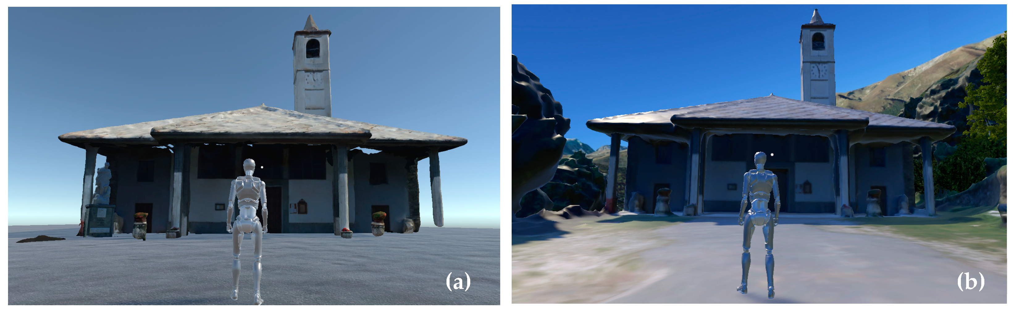
The best results for the provided input data were achieved with 100,000 steps for both settlement models, processing took 2.5 and 1.5 h, respectively, for Villa and Sant’Antonio. Sant’Antonio’s output result presented better quality compared to photogrammetric mesh model; however, the Villa model showed an abundance of splat artifacts (Figure 7). The reason for that lies in how the initial recording was conducted; the Villa area recording did not completely follow the capturing guidelines. It is also possible to edit splat files using plugins in Unreal Engine (Version 5.3), Unity (Version 2022.3.9.f1), Blender (Version 4.0), standalone web-based tool PlayCanvas SuperSplat (Version 0.19.2) [33], or a more sophisticated method of splats editing—GaussianEditor [34]. A LumaAI splats to mesh converter tool was used as well to compare with traditional photogrammetric mesh results on a smaller scale for one church (Figure 8). The comparison shows that converting to mesh from splats significantly reduced the initial quality of 3DGS model.

Figure 7.
(a) Sant’Antonio 3DGS model at 100k iteration steps; (b)Villa 3DGS model at 100k iteration steps; (c) Sant’Antonio photogrammetric mesh model; (d) Villa photogrammetric mesh model.

Figure 8.
(a) Splats to mesh model; (b) photogrammetric mesh model.
3.3. Comparison of Two Techniques
WebGL (Web Graphics Library), a JavaScript API, is widely used by most metaverse interfaces, including Mona. The digital 3D environment here was created with Unity using the Mona metaverse engine for its capacity to create interactive environments digitally. WebGL is required to render 3D graphics in web browsers but currently does not support compute shaders, making it difficult to implement 3D GS in the metaverse. Another issue with GS is that although it can render faster on the GPU when compared to photogrammetry, the PLY (Polygon File Format), which is the GS output file format, has a large memory footprint that is not suitable for web applications [35]. Although some progress is being made to compress these splats more effectively for use on the web [36], GS remains incompatible with the Mona interface to this day. As for the future prospects, 3D GS sets a new benchmark for 3D graphics in film production, gaming, AR, VR applications, and the metaverse [37]. Leveraging the integration of AI technologies, this digital recording methodology holds significant promise in facilitating the creation of immersive, real-lifelike environments.
Considering equal hardware conditions and an identical number of source images, a comparison between the two techniques can be conducted. The pros and cons of photogrammetry and gaussian splatting methods are summarized below.
Photogrammetry, despite its efficacy in generating detailed models, exhibits longer processing times, as evidenced by the approximately 10-h duration for the Villa model and 7-h duration for Sant’Antonio. Additionally, Web3 environments require optimization of the output 3D model; this involves utilizing additional software, such as Blender (Version 4.0), to retexture and simplify the mesh. Moreover, the requisite expertise in photogrammetry software like Agisoft Metashape (Version 2.1.0) poses a constraint, demanding professional knowledge for effective implementation, thereby limiting the proposed strategy’s accessibility. The output mesh model has several advantages: convenient editing tools, considering the time-tested development of technique, and metaverse applications based on WebGL being adapted for mesh.
Gaussian splatting demonstrates expedited processing, notably completing the Villa model in 2.5 h and Sant’Antonio model in 1.5 h. Despite its current incompatibility with metaverse platforms due to WebGL limitations, its applicability to VR and AR environments remains feasible through software like Unity (Version 2022.3.9.f1) and Unreal Engine (Version 5.3). The accessibility of user-friendly tools, exemplified by Postshot software’s ‘drag and drop’ functionality, renders GS technology accessible to a broad spectrum of PC users, potentially creating an opportunity for strategy simplification. One of the disadvantages of this technique is that the editing capabilities are rudimentary, tools such as SuperSplat (Version 0.19.2) and GaussianEditor enable only basic splat modifications, including selection, removal, relocation, scaling, and rotation. Three-dimensional GS presents promising prospects for the future of 3D environment creation, characterized by optimized rendering performance conducive to mobile devices, exemplified by the capabilities of Luma AI. This underscores its potential as a versatile and efficient tool for advancing immersive digital environments.
With the advance of new tools and implementation of 3D GS into metaverse this technology is a promising tool for the digitization part of this strategy. Because the main limitation is the metaverse web application, which currently does not support Gaussian splats, a photogrammetric model was chosen for further study in the metaverse-based workflow.
3.4. Model Optimization
Once the images had been processed on Agisoft Metashape, the output obtained was a textured 3D model with a few imperfections, which further underwent post-production processes to improve quality and remove unnecessary details that were recorded during the on-site mapping process. For instance, retopologizing the model and removing trees, vehicles, and artifacts [21], then replacing them with animated objects to create a cleaner, uninterrupted model for a better user experience in the metaverse. As mentioned in the introduction, modeling was carried out considering the need for a metaverse and not an as-is reconstruction reflecting the actual conditions of the site. For this reason, editing becomes essential to correct unwanted elements in the mesh model.
WebGL extends interactive space capabilities to the web, enhancing accessibility with easy sharing, but has additional considerations due to rendering limitations. Key considerations include optimizing assets for performance by reducing polycount and draw calls, ensuring compatibility with various browsers, and balancing quality with file size when creating textures, while employing techniques like lightmapping for enhanced visual quality [38].
The performance optimization steps in Blender and Unity involve simplifying mesh for colliders, re-texturing, monitoring frames per second (FPS), and incorporating interactive elements to create an immersive 3D environment. Collider is a mesh to handle collisions between objects in Unity, for instance it allows the character to walk on the surface. To optimize the performance, they need to be simplified as much as possible while retaining general outlines of the corresponding model; the initial number of mesh triangles was 1,093,105 and after a 95% simplification it was reduced to 54,655 faces (Figure 9).
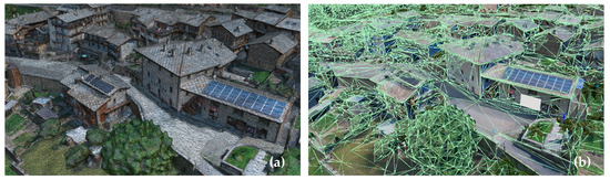
Figure 9.
(a) Initial mesh; (b) simplified collider mesh.
Guidelines for improving performance include implementing level-of-detail (LOD) systems and optimizing texture sizes for each element. Interactive 3D objects were given an LOD, where the polycount of the object reduced according to the distance from the camera, allowing a reduction in the amount of polygon space needed to render at the same time. Resolution of objects textures was limited to maximum of 512 × 512 pixels. These steps allowed us to decrease the FPS of the Mona space compared to the unoptimized model.
3.5. Minting Process for Ostana in Mona Space
Minting in this context refers to the technical process of converting digital assets, such as 3D models or virtual environments, into unique blockchain tokens. This is achieved by creating and registering a smart contract on the blockchain that defines the rules for the asset’s usage, such as its ownership, transferability, and any royalties associated with its use. The digital asset is then linked to this smart contract, effectively turning it into a non-fungible token (NFT) that carries all its metadata and ownership details, thereby certifying its authenticity and uniqueness on the blockchain. This process of digitizing the environment involved finalizing Mona spaces and then publishing them on the Polygon MATIC blockchain, which offers a cost-effective and environmentally friendly alternative to the Ethereum blockchain [39]. Minting the space allows creators to receive incentives for their work on digitization, thereby generating economic value during the process. Minting digitized environments, such as Mona spaces, is essential to allow the recording of digital assets ownership and transactions on the blockchain. To authenticate the ownership of the asset on the blockchain (created metaverse space), this process creates a unique digital token, often in the form of NFT. These assets can be bought, sold, and traded within the blockchain ecosystem, providing a secure and transparent marketplace for 3D reconstruction specialists and metaverse developers. Minting allows contributing stakeholders to monetize their work by receiving incentives and royalties for their contributions to digitization efforts, thus generating economic value for the process. Minting on a blockchain platform like Polygon MATIC ensures interoperability with other blockchain-based applications and platforms, facilitating broader adoption and integration of digitized environments into the larger ecosystem.
4. Metaverse-Based Participatory Design
4.1. Concept of Participatory Design
Through the case study of Ostana, the paper explores a comprehensive digital strategy for community-led development. In the quest to revitalize decaying rural areas, the workflow introduces participatory design concepts using both traditional and Web3-based interaction methods drawing comparisons to showcase the importance of collaboration between design professionals and the stakeholders integrating metaverse, blockchain technologies along with smart contracts presenting a transformative approach in the field of architecture engineering and construction (AEC), reshaping client–contractor relations.
Participatory planning and architectural design, characterized by the active involvement of stakeholders, particularly residents, in optimizing public building spaces, has been conceptualized as an integral component of citizen design science by scholars [40,41]. Its practical application has garnered widespread acclaim [42,43]. For instance, some satellite cities in the UK have progressively shifted from top-down to bottom-up decision-making approaches in the pursuit of sustainable urban transformation [44]. Similarly, in the Puglia region of Italy, the engagement of community residents in the revitalization of urban public spaces is celebrated as a distinctive cultural landscape preservation strategy, contributing to the maintenance of the city’s vibrant energy [45]. The merits of participatory design manifest across several dimensions. Firstly, it accentuates the centrality of residents and facilitates a democratic decision-making framework [46]. Secondly, engagement in community design endeavors enriches inhabitants’ sense of identity and attachment to their surroundings [47]. Crucially, in pursuit of fostering a habitable and resilient environment conducive to public welfare, public participation enables the mobilization of citizens’ competencies and experiences, thereby engendering superior outcomes concerning the planning, construction, and assessment of projects [48].
Nonetheless, participatory design encounters limitations. It requires substantial financial and temporal resources [49]. Additionally, it tends to attract individuals inclined towards public participation, potentially skewing the representation of diverse viewpoints [50]. Furthermore, existing tools for facilitating online collaborative design among multiple stakeholders are deemed insufficient [51]. Should these drawbacks be solved, participatory design leveraging residents’ initiative holds considerable advantages in the creation and provision of functional public spaces.
4.2. Metaverse-Based Design on a Case Study: Two Approaches for Community Engagement
Following a site visit, consultations with residents, and in-depth research on Ostana, it became apparent that the village lacks essential infrastructure, such as communal gathering spaces, seating areas, temporary stalls for markets, and abandoned buildings with the potential for repurposing [52]. By adapting to advancements in the construction industry and embracing innovative design principles, the objective of the project is to create inclusive, sustainable, and vibrant spaces that enrich the lives of residents and visitors alike. Through collaboration and creativity, Ostana can emerge as a model for abandoned rural community development, showcasing the power of innovative thinking, community engagement through the metaverse [21].
However, it is crucial to adhere to the community’s construction and renovation constraints; hence, the design brief prioritizes creating a versatile, adaptable space that meets the diverse needs of the community while respecting Ostana’s architectural heritage and construction guidelines. The primary goal is to establish a modular timber pavilion for community gatherings using discrete timber elements that are adaptable to various building types and functions. This pavilion should be easily assembled and dismantled, facilitating its flexible use as street furniture, temporary kiosk, sunshade, ingenious sculpture, or other architectural enhancements that authentically encapsulate the ingenuity of the local people.
Along with other interactive options such as education, economy generation, and virtual tourism experiences, the decision-making in metaverse is a key factor in the proposed design strategy [21]. Based on the created photogrammetric 3D model, metaverse offers an immersive virtual environment replete with enriched experiences and concurrently functions as a platform capable of engaging a diverse array of participants. Employing it as a platform for participatory design addresses two key challenges: firstly, the inherent online nature of the metaverse enables the accommodation of the interests of a sufficient number of stakeholders effortlessly; secondly, its online functionality promotes universal participation, thereby mitigating the potential risk of underrepresentation and enhancing inclusivity [53].
Hence, drawing upon distinct stages of residents’ involvement within the design process, two solutions of metaverse-based participatory design are proposed (Figure 10): top-down approach, which is based on ShapeDiver; bottom-up approach, which is based on Voxels.
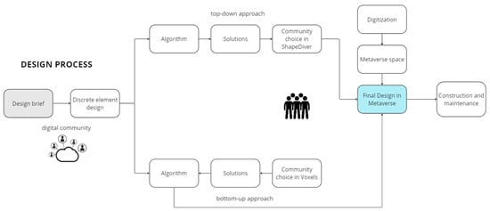
Figure 10.
Discrete element design concept.
ShapeDiver is a cloud-based platform that enables users to create parametric 3D models and interactive configurators using Rhino and Grasshopper. It allows users to upload their Grasshopper definitions and convert them into web-based applications accessible through a web browser [54]. While ShapeDiver is not directly integrated with metaverse environments, it is possible to embed a link to the ShapeDiver configurator within the created metaverse space thereby establishing an interconnected Web3 network. Stakeholders can interact with customizable 3D models in real-time, adjusting parameters and exploring various design variations without needing prior knowledge of 3D modeling or programming.
In contrast, Voxels emerges as a user accessible metaverse platform underpinned by the Ethereum blockchain infrastructure. Analogous to the constructivist environment of Minecraft, Voxels constructs its virtual milieu entirely from discrete blocks. This approach empowers users, regardless of their proficiency in architectural or 3D modeling domains, to articulate their concepts and preferences adeptly, akin to a gamified interaction. Particularly notable is Voxels’ alignment with UN-Habitat’s ‘block by block’ initiative, which advocates for inclusive participation in urban planning processes, thereby amplifying the voices of marginalized communities often marginalized in decision-making contexts [55].
4.3. Top-Down Approach: ShapeDiver
The top-down architecture design approach involves the hierarchical imposition of design decisions, typically by professionals or authorities, onto architectural projects. This method centralizes the decision-making authority at the top levels of the design process, often based on predetermined criteria or guidelines. The focus lies on overarching design principles and objectives, which are then implemented throughout the project. While top-down design may offer efficiency and consistency, it may also risk overlooking nuanced local needs and preferences [56].
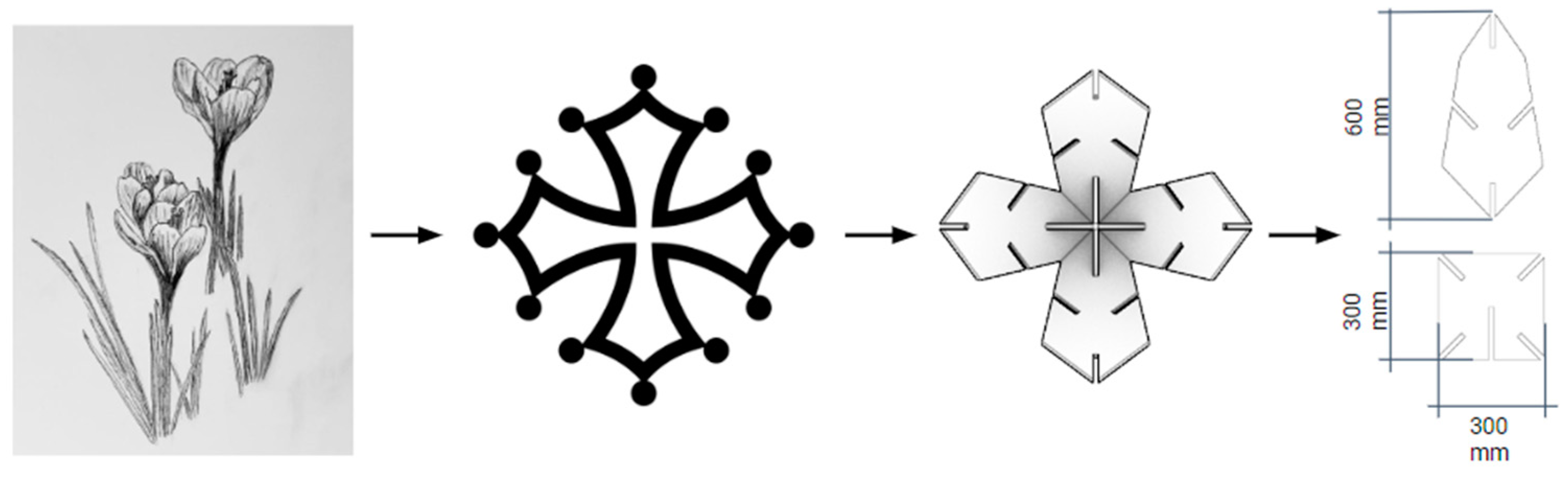
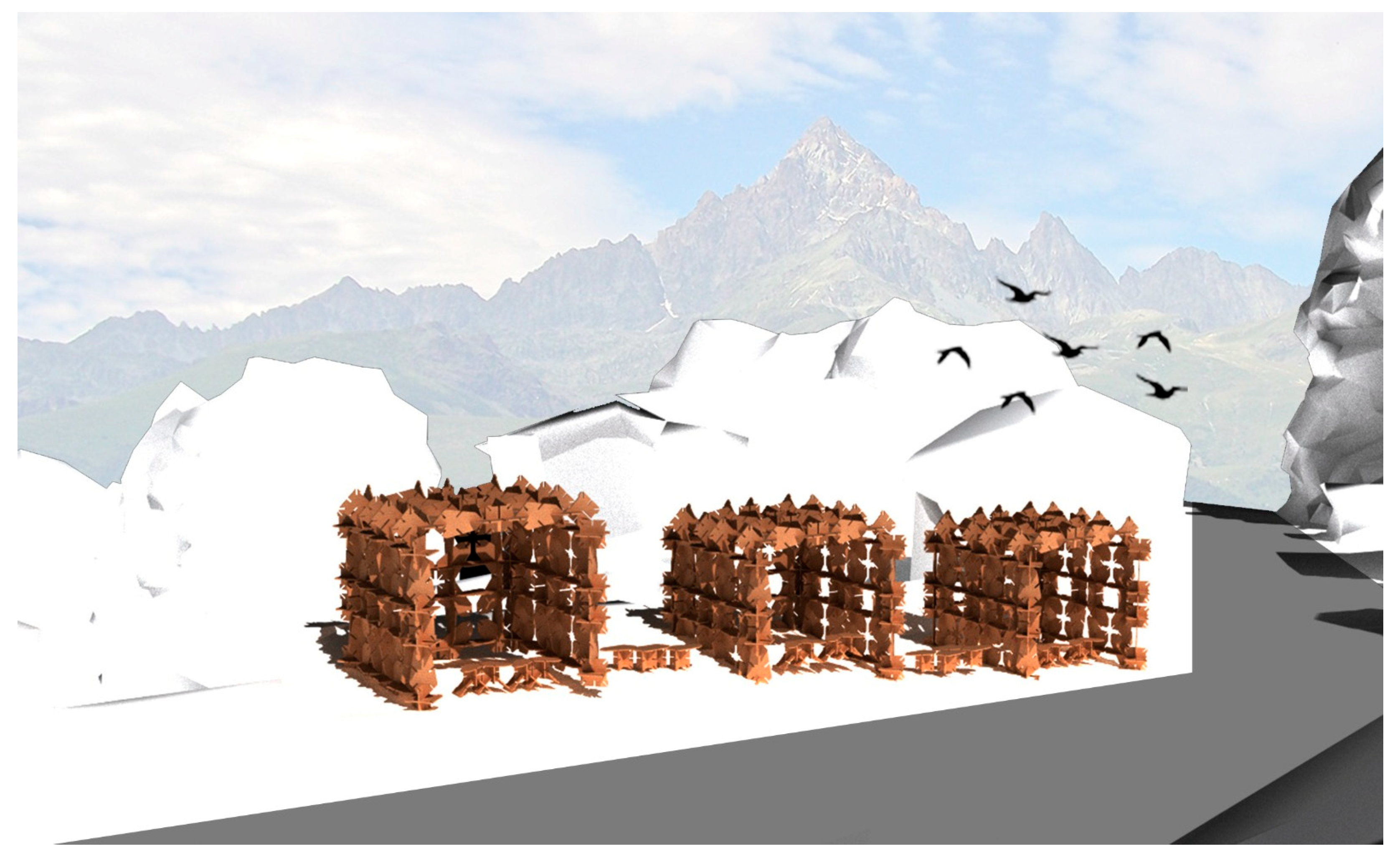
In the Ostana case, the top-down approach is executed through ShapeDiver. The design process commences with the creation of discrete elements, influenced by the Alpine wildflower, crocus, and grounded in the Occitanian cross. These two components, shaped as diamonds and squares, respectively, represent the petals and receptacle of the flower (Figure 11). This design utilizes the ample local wood resources, while also resonating with traditional construction techniques.
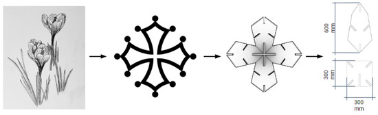
Figure 11.
Concept evolving from crocus flower to Occitanian cross. Composed by discrete elements to detailed size of discrete elements.
Upon thorough verification, an algorithm using Fox, a plugin for Grasshopper in Rhino, was created to populate these discrete elements into different forms and create aggregations of pre-established shapes (Figure 12).
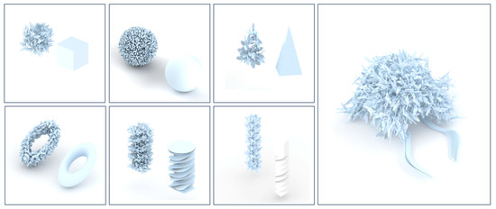
Figure 12.
Fox aggregations using discrete modules.
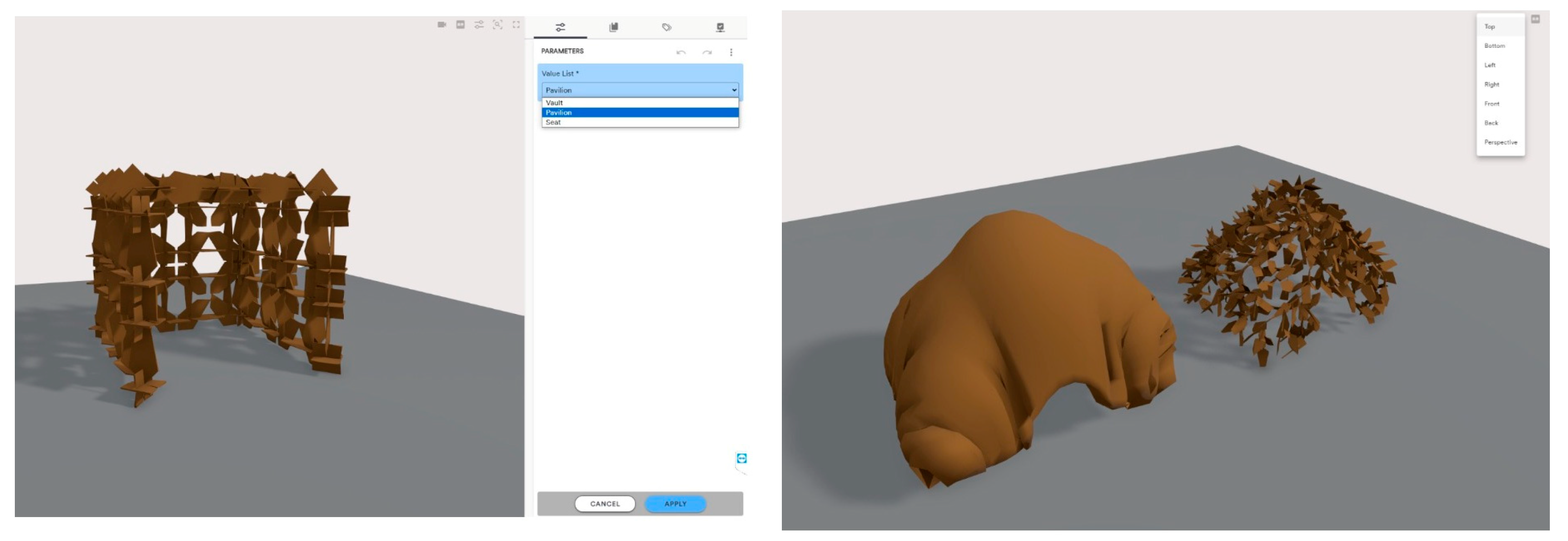
As part of the research, discrete results generated from the Fox plugin are further baked into Grasshopper and uploaded to the ShapeDiver platform. From the available solutions, the stakeholders can choose between the ready-made options, by toggling sliders and changing defined parameters, facilitating collaborative design exploration (Figure 13). The customizable parameters include shape, color, texture, type of view (front, back, perspective, etc.), and functions, such as pavilions and furniture, for now, with the potential to elaborate on these for future requirements.
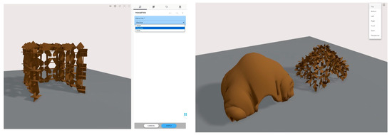
Figure 13.
ShapeDiver interface for ready-made design exploration, the platform allows user to change to change colors and choose between preselected design options.
While this method offers efficiency and consistency by centralizing decision-making authority and utilizing predefined parameters, it also presents several constraints. Firstly, mass participation occurs at a delayed stage, with limited capacity to ignite public enthusiasm. Additionally, while algorithm-generated element aggregation offers a breadth of solutions, these lack creativity and structural redundancy. Stakeholders’ input may be limited by the pre-established shapes and parameters provided by the algorithm and the discrete elements. Secondly, technical limitations imposed by the capabilities of the software tools may restrict the complexity and variety of shapes, colors, textures, and functions that can be implemented. Moreover, the top-down approach may introduce biases or limitations based on the perspectives and preferences of the professionals or authorities creating the initial designs, potentially overlooking nuanced local needs and preferences. Finally, there may be resource constraints related to the availability, sustainability, and budget of local wood resources and traditional construction techniques utilized in the design process.
4.4. Bottom-Up Approach: Participatory Design Workshop in Metaverse and Offline
The bottom-up architecture design approach emphasizes the active involvement of stakeholders in the conceptualization and development of architectural projects. This method prioritizes grassroots input and seeks to address the specific needs and preferences of the community or individuals within it. By engaging stakeholders from the outset, bottom-up design aims to create more inclusive and contextually relevant architectural solutions [57].
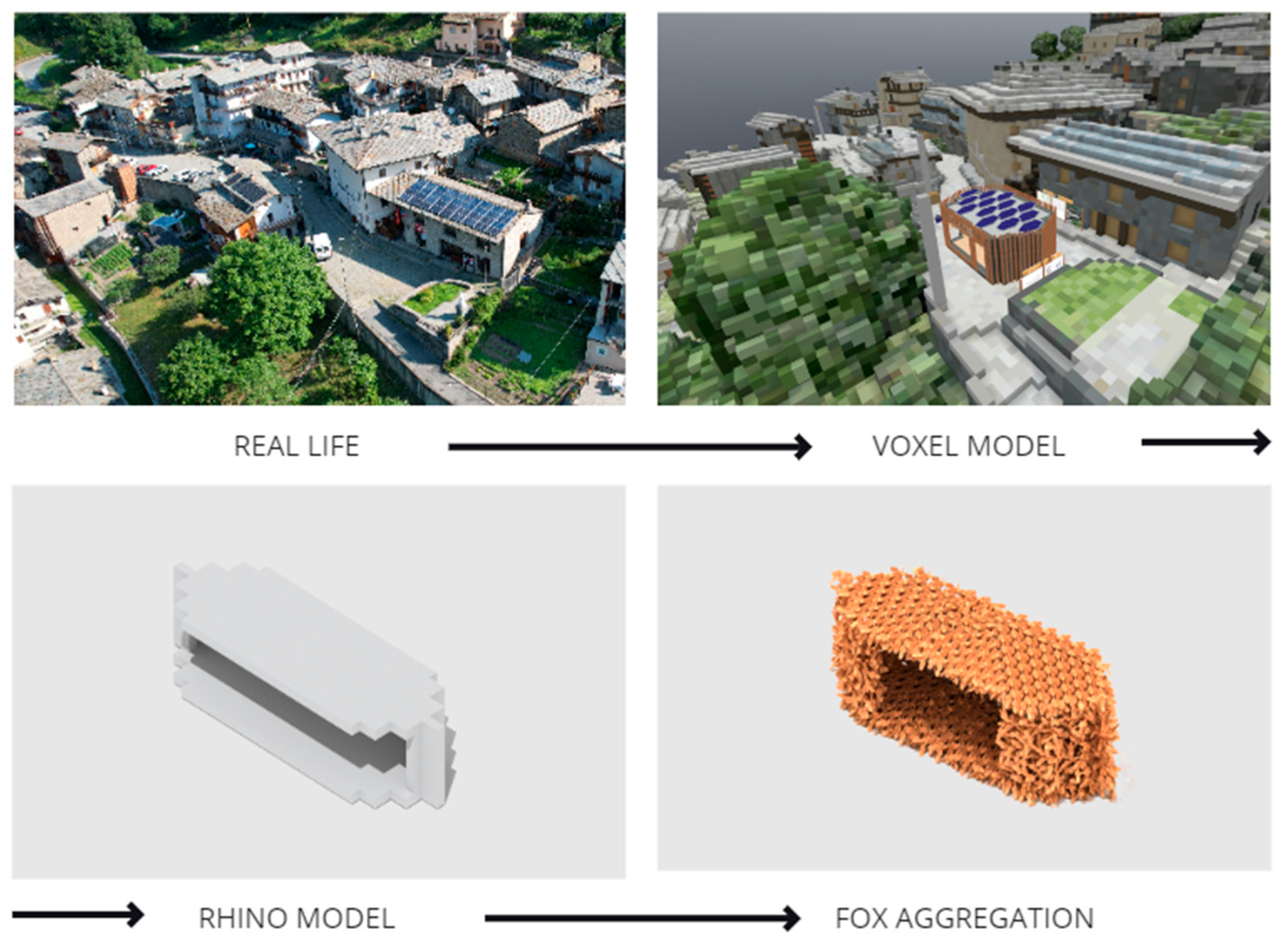
In the Ostana case, the bottom-up design approach is facilitated via Voxels. Users engage in an online participatory process during the initial phase of design. Their design concepts are then transmitted to architectural designers for implementation and realization. The design initiation involved the introduction of Voxels, where the physical context of Ostana, captured through photogrammetry, was transformed into cubic blocks called Voxels Small part of the model made out of five 63 × 63 × 63 m squares was cut from the mesh in Blender following the scale of 2 voxels per meter and platform limitation on the voxelized models’ size. The FileToVox and MagicaVoxel tools were then utilized to convert the mesh into a vox format (Figure 14). Voxelization simplifies complex architectural concepts into block-based representations, enabling intuitive visualization and interaction within the design space. This approach fosters inclusive participation from community members of varying backgrounds and facilitates the integration of designs into the metaverse.
Figure 14.
Voxelized part of Ostana which is used as a base for the participatory design workshop in metaverse.
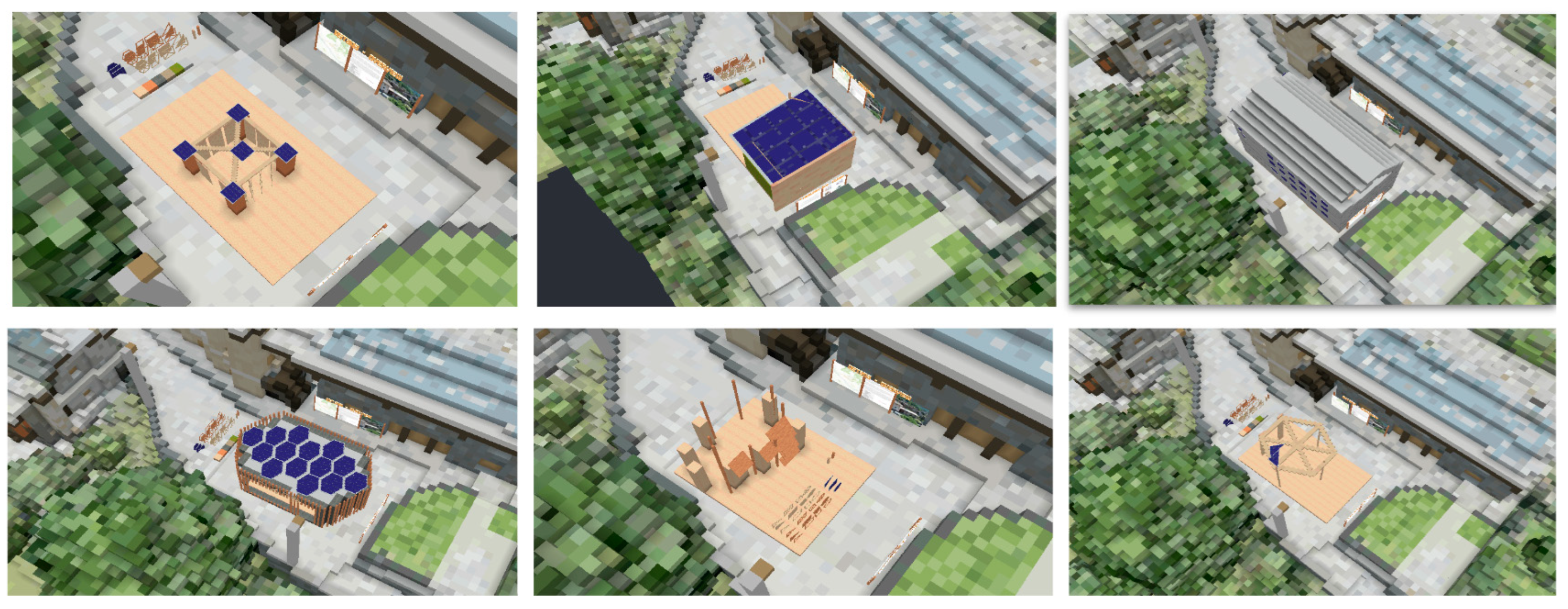
Preceding the onset of participatory design, residents were instructed on how to navigate the voxel space through the special guidebook was created with introduction to the design process, information about the village and instructions on the platform’s interface. Utilizing Voxels, a metaverse platform leveraging the Ethereum blockchain, users are able to articulate their individual architectural visions, akin to a simplified game of building blocks. This aids designers in gathering streamlined design propositions from the community. Participants of mainly adult demographics (age 25–44) representing the community residents were invited to create their own metaverse space and build a small structure for the community gathering with vox modules and blocks (Figure 15).

Figure 15.
Set of proposals made during the Voxels workshop.
A total of twelve solutions were pitched through this approach, with certain solutions being selected by the designers and subsequently translated into simplified shapes within Rhino (Figure 16). These solutions were then employed to aggregate via interlocking using the Fox algorithm in Grasshopper, a plugin tool referenced earlier in the study, to develop discrete elements for form advancement prior to construction.

Figure 16.
Real-life topography converted to voxel model, then transformed into buildable structure using Fox algorithm.
Voxels offers several advantages in engaging stakeholders from the outset and prioritizing grassroots input for more inclusive and contextually relevant architectural solutions. However, this approach also presents certain limitations that warrant consideration. Firstly, while Voxels facilitate the articulation of individual architectural visions in a simplified manner, complex operations such as rotation and splicing remain challenging within the virtual space. This limitation may constrain the range of design possibilities and hinder the realization of more intricate or innovative architectural concepts and the solutions contributed by participants may lack aesthetic appeal or distinctiveness. Without expert guidance or intervention, there is a risk that the resulting architectural solutions may not fully reflect the collective aspirations or vision of the community. Furthermore, the translation of selected design solutions into simplified shapes within Rhino and their subsequent aggregation using the Fox algorithm may result in a loss of complexity or fidelity, potentially compromising the richness and depth of the original design concepts.
Another significant limitation is the inability to replicate the designed discrete elements within the voxel-based platform, necessitating a constraint to simplified voxel shapes. This constraint underscores the importance of enabling participants to directly interact with the designed pieces. Consequently, conducting additional workshops in an offline environment becomes essential due to the inherent challenges in replicating the interaction with designed pieces within an online metaverse platform. The offline setting facilitates more accurate and effective manipulation and assessment of discrete elements, which is critical for testing and refining complex architectural solutions. Additionally, the offline environment allows for a more efficient and immediate evaluation process, enabling rapid prototyping and iteration that might be constrained by the limitations of current online tools. This approach ensures a more precise translation of design concepts into tangible outcomes later to be showcased in the created Mona space.
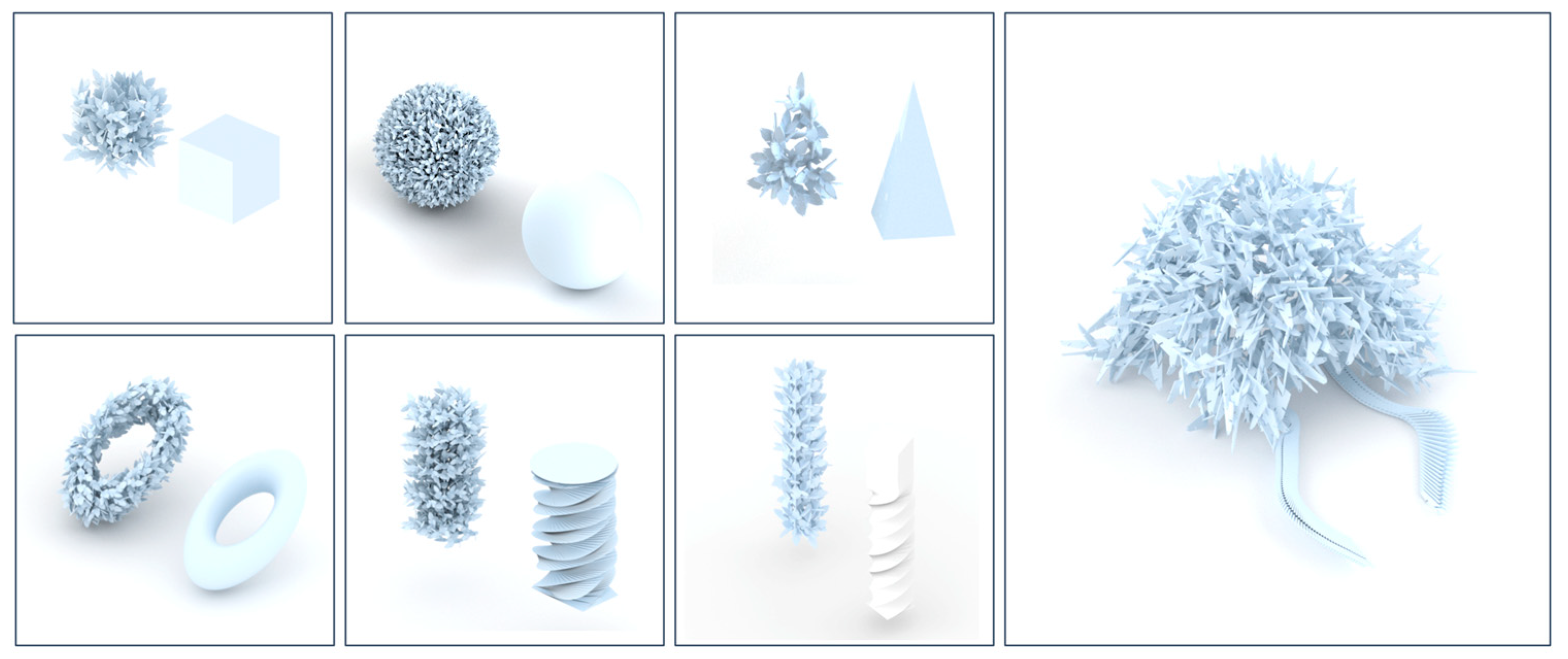
In practice, individuals engaged in participatory design frequently possess limited expertise and lack knowledge of architectural design principles. To replicate the stakeholder engagement dynamics inherent in participatory design and evaluate the efficacy of previously designed discrete elements in nurturing participants’ creativity, as well as to investigate the resulting amalgamated creative configurations, a study was undertaken involving 60 participants from kindergarten and high school demographics, simulating the role of residents of the case study community. Attendees were invited to a workshop where they actively participated in the assembly of components (1:10 scale 3D printed PLA plastic prototypes) independently.
The participants were organized into five groups, comprising two groups from kindergarten and three groups from high school. Each group, regardless of age, was allotted less than 10 min for this workshop. While the kindergarten group did not receive any specific theme, each high school group was assigned a distinct theme and instructed to collaborate accordingly. For instance, certain high school groups were tasked with constructing either a bridge or a sculpture individually, whereas others were required to collectively complete an arch with a team comprising 12 members.
Overall, within the constrained timeframe, the outcomes were remarkable (Figure 17). Among the results from the kindergarten children, several intricate three-dimensional structures emerged, exhibiting impeccable symmetry and a beauty that warrants realization in physical form. Moreover, the children discerned floral inspirations within the components. For high school students, the complexity of outcomes varied. The first two groups completed their designs as individual units, showcasing a notably high level of intricacy, with some even featuring spatial curves and closed loops beyond Grasshopper’s programming capabilities. However, the final group, tasked with collaborative construction of the arch, was unable to complete the task within the allotted time.
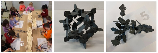
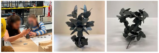
Figure 17.
Pictures from participatory design workshop.
This workshop effectively showcased residents’ enthusiasm and creativity within participatory design. Given extended duration and guidance from professional practitioners, it implies that the people-centric design of community public infrastructures could comprehensively incorporate each resident’s inspiration and needs, thereby enhancing resilience and sustainability.
However, certain designs exhibit aesthetic appeal but lack structural integrity due to the use of plywood as the actual building material. Plywood components are larger, heavier, and less flexible compared to 3D printed plastic counterparts. Moreover, as highlighted by the team that collaborated but ultimately did not complete their task, participatory design necessitates an organizer to unify all members and facilitate the design process in an organized manner. Otherwise, it risks becoming time-consuming, resource-intensive, and susceptible to failure. The main limitation of the workshop is that it was conducted in offline context without the use of metaverse as a primary tool for engagement. Similar gamification mechanisms could be implemented to create an online workshop in metaverse space to facilitate seamless Web3 workflow.
4.5. Metaverse-Based Holistic Participatory Design Approch
The workshop’s insight suggests that the previously discussed top-down and bottom-up design approaches may not yield optimal outcomes. In participatory design, citizen involvement should extend seamlessly from the initial design phase to program selection. This underscores the necessity of advocating for a holistic design methodology that mixes both approaches.
In this integrated design approach (Figure 18), during the initial design phase, professionals are tasked with guiding residents to contemplate the transformational needs of the community environment and identify social function deficiencies. This dialogue occurs through online design and assembly sessions, supplemented by a showcase of proposals within the virtual realm of the metaverse. These participatory design workshops are conducted through Web3 platforms such as Voxels or other applicable tools. The emphasis is placed on understanding the relationship between the newly envisioned public space and its surrounding environment.
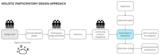
Figure 18.
Holistic participatory design approach.
In the subsequent design phase, architects and structural engineers actively solicit straightforward expressions from residents, prioritizing their desires in exploring practical, safe, aesthetically pleasing, and cost-effective options for public space construction. The metaverse serves as a conduit for seamless communication between residents and experts, facilitating convenient interaction through ShapeDiver.
Furthermore, the integration of blockchain technology within the metaverse establishes economic ties, forming a closed loop encompassing design, construction, and inspection processes through smart contracts [58]. Selected proposals are presented in the created Mona space, which represents the optimal platform for testing the efficacy of the design project. Involved stakeholders can cast a blockchain vote (Figure 19) to preferred options, which ensure security and transparency of the process, making the design process truly democratic [59]. Selected options are then minted in OpenSea as NFTs, creating an additional economic incentive for designers (Figure 20).
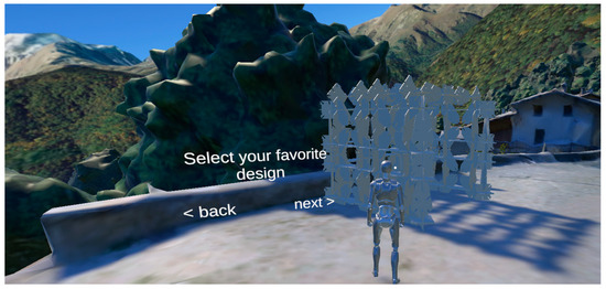
Figure 19.
Selecting and voting for the design in metaverse space.
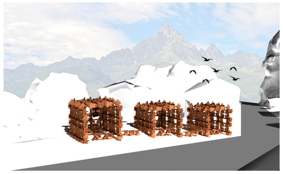
Figure 20.
The figures show final buildable pavilions in Ostana to be minted as NFT.
This comprehensive design methodology, centered on the metaverse, harnesses the initiative and creativity of citizens while also encompassing a broad spectrum of professional viewpoints. It successfully mitigates the time-consuming nature and unverified assumptions in a bottom-up approach, while also addressing the dearth of accessible visual information and efficient communication channels for end-user’s characteristic of a top-down approach.
4.6. Blockchain-Based Construction and Maintenance
For the construction stage, a blockchain-based microfactory concept is proposed. When the full design is finished and approved by the community, it can arrive at the manufacturing assembly stage. Microfactories, derived from the principle of local production and automation, could start with simple programmable machines, such as miller or CNC, and gradually develop into more sophisticated robotic machines to produce complex designs. The concept could be economically viable, given that purchasing machines is cheaper than hiring manual labor. The self-ownership of this concept also makes it more cost-effective and sustainable [60]. Automated microfactories will receive smart contract-bound orders from metaverse designers to fulfill the needs of the nearby communities and cover maintenance and production costs. Designers would need to program the machines to produce the required modules or architectural elements before the final stage of transportation and assembly on site. As final designs will exist in a digital copy of the village, inhabitants can assemble it accordingly, following the instructions in the metaverse.
5. Conclusions
The paper presents an exploration into the integration of digital recording techniques, metaverse platforms, and blockchain technology to foster community engagement and economic growth. By leveraging low-cost digital recording methods, like photogrammetry and Gaussian splatting, the research showcases the potential of Web3 environments to mirror real settlements, as demonstrated through the case study of Ostana. The adoption of participatory design processes highlights a paradigm shift towards more inclusive and community-driven approaches to urban revitalization.
The study’s key insight is the transformative potential of immersive digital environments in fostering community identity and social cohesion. Through the proposed participatory design approach, residents are empowered to actively shape their built environment through the metaverse, resulting in spaces that resonate with their needs. Moreover, the integration of blockchain technology enables decentralized governance models, providing residents with greater control over decision-making processes and resource allocation.
However, it is important to acknowledge the limitations and challenges inherent in the proposed approach. The accessibility and usability of drone surveys, which are vital for the digitization process, may pose barriers to entry for certain communities, particularly those with limited technical expertise or resources. Additionally, the study solely presents a participatory design framework that is founded on the concept of the metaverse. The reliance on invited participants rather than direct involvement from the local community in the case study village may introduce biases and limit the representativeness of the design solutions, since the purpose of the online and offline workshops is solely to test the feasibility of implementing these methods, but they do not provide a means to assess the actual impact of this strategy. Further comprehensive research is required in the future to delve into metaverse development, strategies to engage local communities, and close collaboration with local governments to assess the practical worth of this approach. Furthermore, the concept of connecting local factories to the metaverse using blockchain technology continues to raise economic and practical considerations. In the continuing research, the aim is to achieve a harmonious equilibrium by leveraging digital technology to maximize economic gains for local factories.
The future investigation will focus on the interplay between virtual reality (VR) and augmented reality (AR) within the metaverse framework. Leveraging these technologies, users will have the capability to intuitively assemble discrete elements within virtual environments using hand gestures, thus circumventing reliance on conventional input devices like keyboard and mouse. It holds promise for mitigating the challenges associated with constructing intricate structures on virtual platforms such as Voxels, thereby promoting broader adoption of metaverse design principles among individuals less versed in web operations.
The findings of this research work suggest promising avenues for future research and development. The continued advancement of reality capture technologies, particularly Gaussian splatting, holds the potential to simplify and speed up digitization processes oriented to metaverse applications and make them more accessible to a wider audience due to their ease of use and quicker processing. Furthermore, the integration of AI technologies could further optimize and automate design processes, leading to more efficient and scalable solutions. Overall, the study lays a foundation for further exploration into the intersection of digital technologies and community development, with the potential to drive positive social and economic outcomes through the metaverse.
Author Contributions
Conceptualization, Nikolai Abramov, Havana Lankegowda, Shunwei Liu, Luigi Barazzetti, Carlo Beltracchi, and Pierpaolo Ruttico; methodology, Nikolai Abramov, Luigi Barazzetti, Havana Lankegowda, Shunwei Liu and Luigi Barazzetti; validation, Luigi Barazzetti, Carlo Beltracchi, and Pierpaolo Ruttico; formal analysis, Nikolai Abramov, Havana Lankegowda, and Shunwei Liu; investigation, Nikolai Abramov, Havana Lankegowda, and Shunwei Liu; resources, Pierpaolo Ruttico; writing—original draft preparation, Nikolai Abramov, Havana Lankegowda, and Shunwei Liu; writing—review and editing, Luigi Barazzetti, Carlo Beltracchi, and Pierpaolo Ruttico; visualization, Nikolai Abramov, Havana Lankegowda, and Shunwei Liu; supervision, Luigi Barazzetti, Carlo Beltracchi, and Pierpaolo Ruttico; project administration, Pierpaolo Ruttico. All authors have read and agreed to the published version of the manuscript.
Funding
This research received no external funding.
Data Availability Statement
The original contributions presented in the study are included in the article, further inquiries can be directed to the corresponding authors.
Acknowledgments
The authors sincerely appreciate the invaluable support and guidance provided by Indexlab, including materials, equipment for the research, and the opportunity to organize the online participatory design workshop in Voxels from 1 January 2023 to 31 January 2024 and offline participatory design workshop in Index Lab, Lecco on 11 April 2024. Special thanks are extended to all of the participants from educational institutions in Lecco, as well as to the contributors to the online workshop on the Voxels platform.
Conflicts of Interest
The authors declare no conflicts of interest.
References
- Schumacher, P. The Metaverse as Opportunity for Architecture and Society: Design Drivers, Core Competencies. Archit. Intell. 2022, 1, 11. [Google Scholar] [CrossRef]
- Pamungkas, B. The Future of Cities in Metaverse Era: Are Indonesian Cities Ready. In Proceedings of the 4th Open Society Conference OSC, South Tangerang, Banten, 7 July 2022. [Google Scholar]
- Meng, X.; Li, Y.; Liu, K.; Liu, Y.; Yang, B.; Song, X.; Lin, Y. Spatial Data Intelligence and City Metaverse: A Review. Fundam. Res. 2023, 1–25. [Google Scholar] [CrossRef]
- Zhao, Y.; Jiang, J.; Chen, Y.; Liu, R.; Yang, Y.; Xue, X.; Chen, S. Metaverse: Perspective from Graphics, Interactions and Visualization. Vis. Inform. 2022, 6, 56–67. [Google Scholar] [CrossRef]
- Keil, J.; Edler, D.; Schmitt, T.; Dickmann, F. Creating Immersive Virtual Environments based on Open Geospatial Data and Game Engines. KN-J. Cartogr. Geogr. Inf. 2023, 71, 53–65. [Google Scholar] [CrossRef]
- Hudson-Smith, A.; Batty, M. Ubiquitous Geographic Information in the Emergent Metaverse. Trans. GIS 2022, 26, 1147–1157. [Google Scholar] [CrossRef]
- Alkhatib, Y.J.; Forte, A.; Bitelli, G.; Pierdicca, R.; Malinverni, E. Bringing Back Lost Heritage into Life by 3D Reconstruction in Metaverse and Virtual Environments: The Case Study of Palmyra, Syria. In Proceedings of the International Conference on Extended Reality, Leece, Italy, 6 September 2023; pp. 91–106. [Google Scholar]
- Yang, Z.; Li, J.; Hyyppä, J.; Gong, J.; Liu, J.; Yang, B. A Comprehensive and Up-to-date Web-based Interactive 3D Emergency Response and Visualization System Using Cesium Digital Earth: Taking landslide Disaster as an Example. Big Earth Data 2023, 7, 1058–1080. [Google Scholar] [CrossRef]
- Feng, H. Development of 3D Simulation Platform of Urban Traffic Based on Cesium. Int. J. Front. Eng. Technol. 2022, 4, 25–32. [Google Scholar]
- Zhang, X.; Zhou, W.; Shen, J.; Herman, L.; Du, Y. 3D Interactive Visualization Method of Urban Waterlogging Based on Cesium. In Proceedings of the 29th International Gartographic Conference, Tokyo, Japan, 15 July 2019; pp. 15–20. [Google Scholar]
- Kang, X.; Li, J.; Fan, X. Spatial-temporal Visualization and Analysis of Earth Data under Cesium Digital Earth Engine. In Proceedings of the 2nd International Conference on Big Data and Internet of Things, Beijing, China, 24 October 2018; pp. 29–32. [Google Scholar]
- Guo, H.; Wang, L.; Chen, F.; Liang, D. Science Big Data and Digital Earth. Chin. Sci. Bull. 2014, 59, 5066–5073. [Google Scholar] [CrossRef]
- Li, D.R.; Zhang, G.; Jiang, Y.H.; Shen, X.; Liu, W. Opportunities and Challenges of Geo-Spatial Information Science from the Perspective of Big Data. Big Data Res. 2022, 8, 3–14. [Google Scholar]
- de Bernard, M.; Comunian, R.; Vigan, F. On GIS and the Creative Economy: Opportunities and Challenges. In A Modern Guide to Creative Economies; Edward Elgar Publishing: Cheltenham, UK, 2022; pp. 36–54. [Google Scholar]
- Cruz Franco, P.A.; Márquez de la Plata, A.R.; Gómez Bernal, E. Protocols for the Graphic and Constructive Diffusion of Digital Twins of the Architectural Heritage That Guarantee Universal Accessibility through AR and VR. Appl. Sci. 2022, 12, 8785. [Google Scholar] [CrossRef]
- Jiang, Y.; Yu, C.; Xie, T.; Li, X.; Feng, Y.; Wang, H.; Jiang, C. VR-GS: A Physical Dynamics-Aware Interactive Gaussian Splatting System in Virtual Reality. arXiv 2024, arXiv:2401.16663. [Google Scholar] [CrossRef]
- Rubloff, M. Gaussian Splatting Brings Art Exhibitions Online with Yulei. Available online: https://radiancefields.com/gaussian-splatting-brings-art-exhibitions-online-with-yulei (accessed on 5 March 2024).
- Soliman, M.M.; Ahmed, E.; Darwish, A.; Hassanien, A.E. Artifcial intelligence powered Metaverse: Analysis, challenges and future perspectives. Artif. Intell. Rev. 2024, 57, 36. [Google Scholar] [CrossRef]
- Vajak, D.; Livada, Č. Combining Photogrammetry, 3D Modeling and Real Time Information Gathering for Highly Immersive VR Experience. In Proceedings of the Zooming Innovation in Consumer Electronics International Conference (ZINC), Novi Sad, Serbia, 31 May 2017; pp. 82–85. [Google Scholar] [CrossRef]
- Aria, R.; Archer, N.; Khanlari, M.; Shah, B. Influential Factors in the Design and Development of a Sustainable Web3/Metaverse and Its Applications. Future Internet 2023, 15, 131. [Google Scholar] [CrossRef]
- Abramov, N.; Lankegowda, H.; Liu, S.; Barazzetti, L.; Beltracchi, C.; Ruttico, P. Metamorphosis: A Digital Approach to Transforming Communities through Photogrammetry and Metaverse. Int. Arch. Photogramm. Remote Sens. Spat. Inf. Sci. 2024, 48, 1–8. [Google Scholar] [CrossRef]
- Almeida, G.G.F.; Almeida, P.; Cardoso, L. Scope Extension of the Metaverse Tourism Concept: Proposing a Research Agenda. J. Infrastruct. Poilcy Dev. 2024, 8, 3483. [Google Scholar] [CrossRef]
- Dzelme, R. Metaverse|Transitioning (To) Future Cities: Transdisciplinary Platforms as Instruments to Democratise Technology for Participatory Use in Building back Neglected Urban Voids of Riga. Master’s Thesis, Architecture, Urbanism and Building Sciences-Delft University of Technology, Delft, The Netherlands, 2022. Available online: http://resolver.tudelft.nl/uuid:f6fda3be-2b23-4539-87bd-8b5e3f37e719 (accessed on 5 March 2024).
- McGrath, S.K.; Whitty, S.J. Stakeholder Defined. Int. J. Manag. Proj. Bus. 2017, 10, 721–748. [Google Scholar] [CrossRef]
- Wang, Z.; Wu, S.; Xie, W.; Chen, M.; Prisacariu, V.A. NeRF: Neural Radiance Fields without Known Camera Parameters. arXiv 2021, arXiv:2102.07064. [Google Scholar]
- Mildenhall, B.; Srinivasan, P.P.; Tancik, M.; Barron, J.T.; Ramamoorthi, R.; Ng, R. NeRF: Representing Scenes as Neural Radiance Fields for View Synthesis. Commun. ACM 2021, 65, 99–106. [Google Scholar] [CrossRef]
- Chen, G. A Survey on 3D Gaussian Splatiing. arXiv 2024, arXiv:2301.03890. [Google Scholar]
- Kerbl, B.; Kopanas, G.; Leimkühler, T.; Drettakis, G. 3d Gaussian Splatting for Real-time Radiance Field Rendering. ACM Trans. Graph. 2023, 42, 1–14. [Google Scholar] [CrossRef]
- Luma, A.I. Available online: https://lumalabs.ai/dream-machine (accessed on 4 March 2024).
- Basso, A.; Condorelli, F.; Giordano, A.; Morena, S.; Perticarini, M. Evolution of Rendering Based on Radiance Fields. The Palermo Case Study for a Comparison Between Nerf and Gaussian Splatting. Int. Arch. Photogramm. Remote Sens. Spat. Inf. Sci. 2024, 48, 57–64. [Google Scholar] [CrossRef]
- Jawset Visual Computing. Available online: https://www.jawset.com/ (accessed on 5 March 2024).
- Rubloff, M. New Radiance Field Platform: Postshot. Available online: https://radiancefields.com/new-radiance-field-platform-postshot/ (accessed on 5 March 2024).
- Huttunen, O. 6 Tools to Edit 3D Gaussian Splatting Models. Available online: https://www.youtube.com/watch?v=9pWKnyw74LY (accessed on 10 March 2024).
- Chen, Y.; Chen, Z.; Zhang, C.; Wang, F.; Yang, X.; Wang, Y.; Lin, G. GaussianEditor: Swift and Controllable 3D Editing with Gaussian Splatting. arXiv 2023, arXiv:2311.14521. [Google Scholar] [CrossRef]
- Moore, T. Mona Developer Team; Personal Communication: London, UK, 2024. [Google Scholar]
- Compressing Gaussian Splats. Available online: https://blog.playcanvas.com/compressing-gaussian-splats/ (accessed on 8 March 2024).
- Gaussian Splatting: The Next Big Thing in 3D. Available online: https://xrvizion.medium.com/gaussian-splatting-the-next-big-thing-in-3d-b37062de2076 (accessed on 5 April 2024).
- Mona Platform Documentation. Available online: https://docs.monaverse.com (accessed on 4 March 2024).
- Alzoubi, Y.I.; Mishra, A. Green Blockchain—A Move towards Sustainability. J. Clean. Prod. 2023, 430, 139541. [Google Scholar] [CrossRef]
- Mueller, J.; Lu, H.; Chirkin, A. Citizen Design Science: A Strategy for Crowd-Creative Urban Design. Cities 2018, 72, 181–188. [Google Scholar] [CrossRef]
- Pissourios, I. Top-down and Bottom-up Urban and Regional Planning: Towards a Framework for the Use of Planning Standards. Eur. Spat. Res. Policy 2014, 21, 83–99. [Google Scholar] [CrossRef]
- Dambruch, J.; Stein, A.; Ivanova, V. Innovative Approaches to Urban Data Management Using Emerging Technologies. In Proceedings of the 21st International Conference on Urban Planning, Regional Development and Information Society, Hamburg, Germany, 22 June 2016; pp. 375–384. [Google Scholar]
- Vogt, M.; Fröhlich, P. Understanding Cities and Citizens: Developing Novel Participatory Development Methods and Public Service Concepts. In Proceedings of the 21st International Conference on Urban Planning, Regional Development and Information Society, Hamburg, Germany, 22 June 2016; pp. 991–995. [Google Scholar]
- Dias, M. Development of a Community Embedded Sustainable Urban Design Process Framework for Neighbourhood Context. Ph.D. Thesis, School of Art, Design and Architecture-University of Huddersfield, Huddersfield, UK, 2015. [Google Scholar]
- Amoruso, G.; Battista, V. Landscape. Bottom-up Approach for Cultural landscape and Local Identity Mapping. In Mind and Places: A Multidisciplinary Approach to the Design of Contemporary City, 1st ed.; Anzani, A., Ed.; Springer: Cham, Switzerland, 2020; pp. 223–236. [Google Scholar]
- Fagence, M. Citizen Participation in Planning, 1st ed.; Urban and Regional Planning Series, 19; Pergamon Press: Oxford, UK, 2014; p. 379. [Google Scholar]
- Saad-Sulonen, J.C.; Horelli, L. The Value of Community Informatics to Participatory Urban Planning and Design: A Case-study in Helsinki. J. Community Inform. 2010, 6. [Google Scholar] [CrossRef]
- Antonova, N.L.; Grunt, E.V. Citizens’ Role in Formation of Urban Environment Design. IOP Conf. Ser. Mater. Sci. Eng. 2019, 687, 055053. [Google Scholar] [CrossRef]
- Hughes, J.A.; Randall, D.; Shapiro, D. From Ethnographic Record to System Design: Some Experiences from the Field. Comput. Support. Coop. Work. (CSCW) 1992, 1, 123–141. [Google Scholar] [CrossRef]
- Bryson, J.M.; Quick, K.S.; Slotterback, C.S.; Crosby, B.C. Designing Public Participation Processes. Public Adm. Rev. 2013, 73, 23–34. [Google Scholar] [CrossRef]
- Lyons, S.H.; Walsh, M.; Aleman, E.; Robinson, J. Exploring regional futures: Lessons from Metropolitan Chicago’s online MetroQuest. Technol. Forecast. Soc. Change 2014, 82, 23–33. [Google Scholar] [CrossRef]
- Bertolino, M.A.; Corrado, F. Culture-Based Practices as Driver of Local Development Processes in Mountain Areas—Evidence from the Alpine Region of the Province of Cuneo (Italy). Sustainability 2022, 14, 13713. [Google Scholar] [CrossRef]
- Catro e Costa, E.; Pires Jorge, J.A.; Knochel, A.; Duarte, J. Enabling Parametric Design Space Exploration by Non-designers. Artif. Intell. Eng. Des. Anal. Manuf. 2020, 34, 160–175. [Google Scholar] [CrossRef]
- ShapeDiver Design Choice Platform. Available online: https://www.shapediver.com/app/m/shapediver-20231208 (accessed on 20 April 2024).
- Westerberg, P.; Heland, F. Using Minecraft for Youth Participation in Urban Design and Governance; United Nations Human Settlements Programme: Nairobi, Kenya, 2015. [Google Scholar]
- Burry, J.; Burry, M. The New Mathematics of Architecture, 1st ed.; Thames & Hudson: London, UK, 2010; pp. 156–162. [Google Scholar]
- Oosterhuis, K. Architecture Goes Wild, 1st ed.; 010 Publishers: Rotterdam, The Netherlands, 2002; pp. 54–66. [Google Scholar]
- Chowdhury, S.; Schnabel, M. An Algorithmic Methodology to Predict Urban Form. In Proceedings of the Adapting and Prototyping—23rd International Conference of the Association for Computer-Aided Architectural Design Research in Asia (CAADRIA), Beijing, China, 14 May 2018; pp. 401–410. [Google Scholar]
- Mattila, V.; Pang, R.; Ahbab, M. Blockchain in Voting: Secured and Transparent Electronic Voting System; UN1TY Ventures LLP: London, UK, 2024. [Google Scholar] [CrossRef]
- Hunhevicz, J.; Wang, H.; Hess, L.; Hall, D.M. NO1S1—A Blockchain-based DAO Prototype for Autonomous Space. In Proceedings of the European Conference on Computing in Construction, Rhodes, Greece, 26 July 2021; Volume 2, pp. 27–33. [Google Scholar]


Disclaimer/Publisher’s Note: The statements, opinions and data contained in all publications are solely those of the individual author(s) and contributor(s) and not of MDPI and/or the editor(s). MDPI and/or the editor(s) disclaim responsibility for any injury to people or property resulting from any ideas, methods, instructions or products referred to in the content. |
© 2024 by the authors. Licensee MDPI, Basel, Switzerland. This article is an open access article distributed under the terms and conditions of the Creative Commons Attribution (CC BY) license (https://creativecommons.org/licenses/by/4.0/).