
A Comprehensive View on Urban Spatial Structure: Urban Density Patterns of German City Regions


Abstract
:1. Introduction
- To present a novel method for a region-wide detection of built densities.
- To demonstrate the practical feasibility of our approach based on four German city regions. In doing so, we illustrate the analytical capacity of fine-grained spatial density data for the characterization of urban spatial structure.
- To shed light on the interrelations between built and activity densities.
2. Conceptualization of Built Density
3. Measuring Built Density
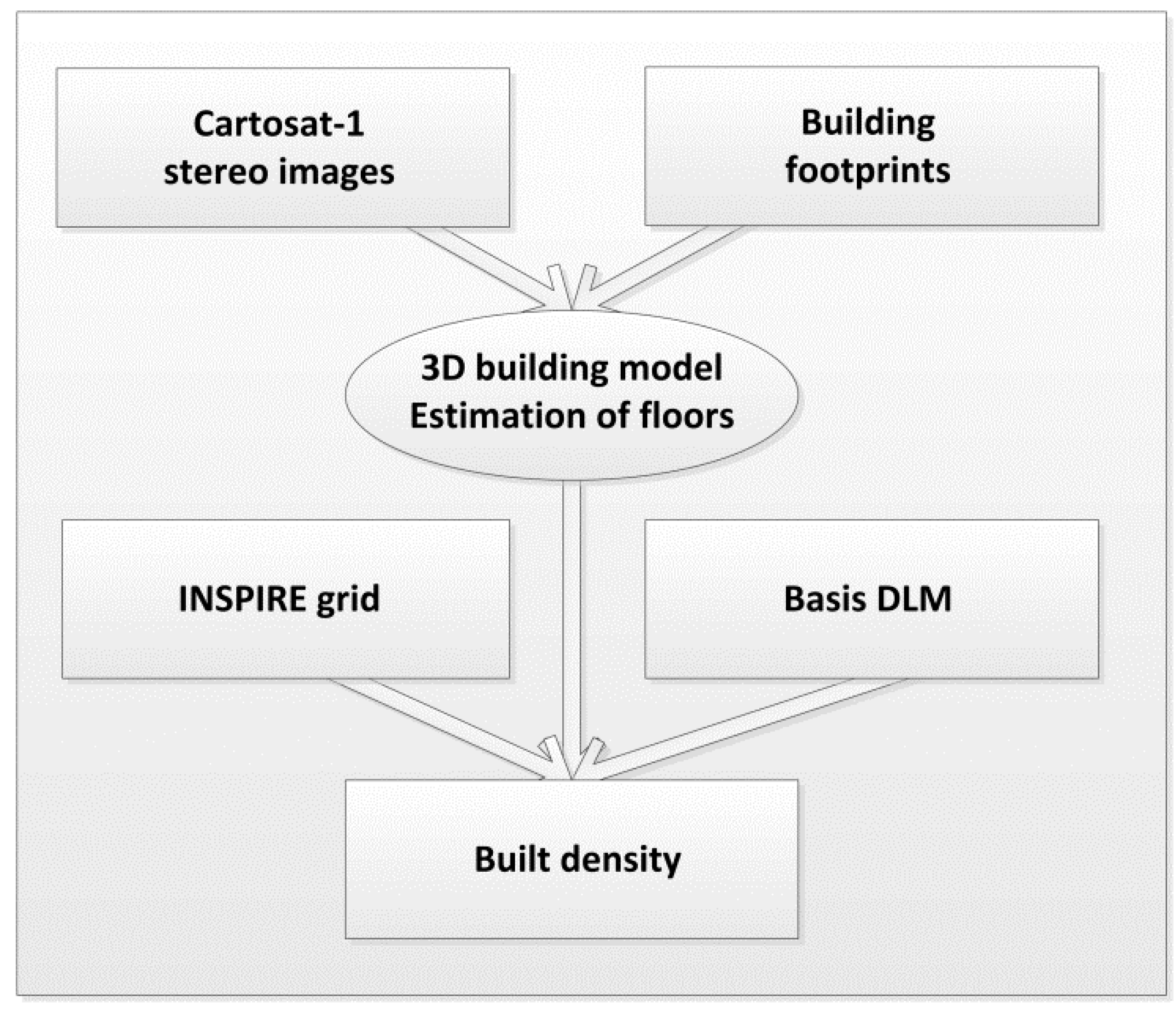
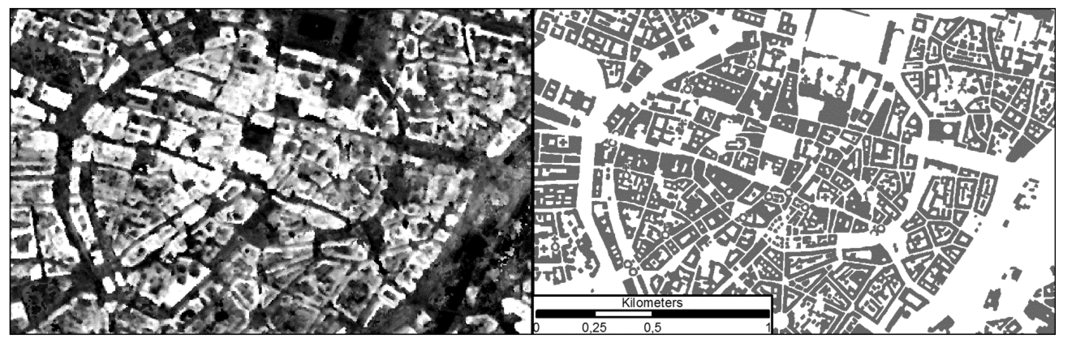
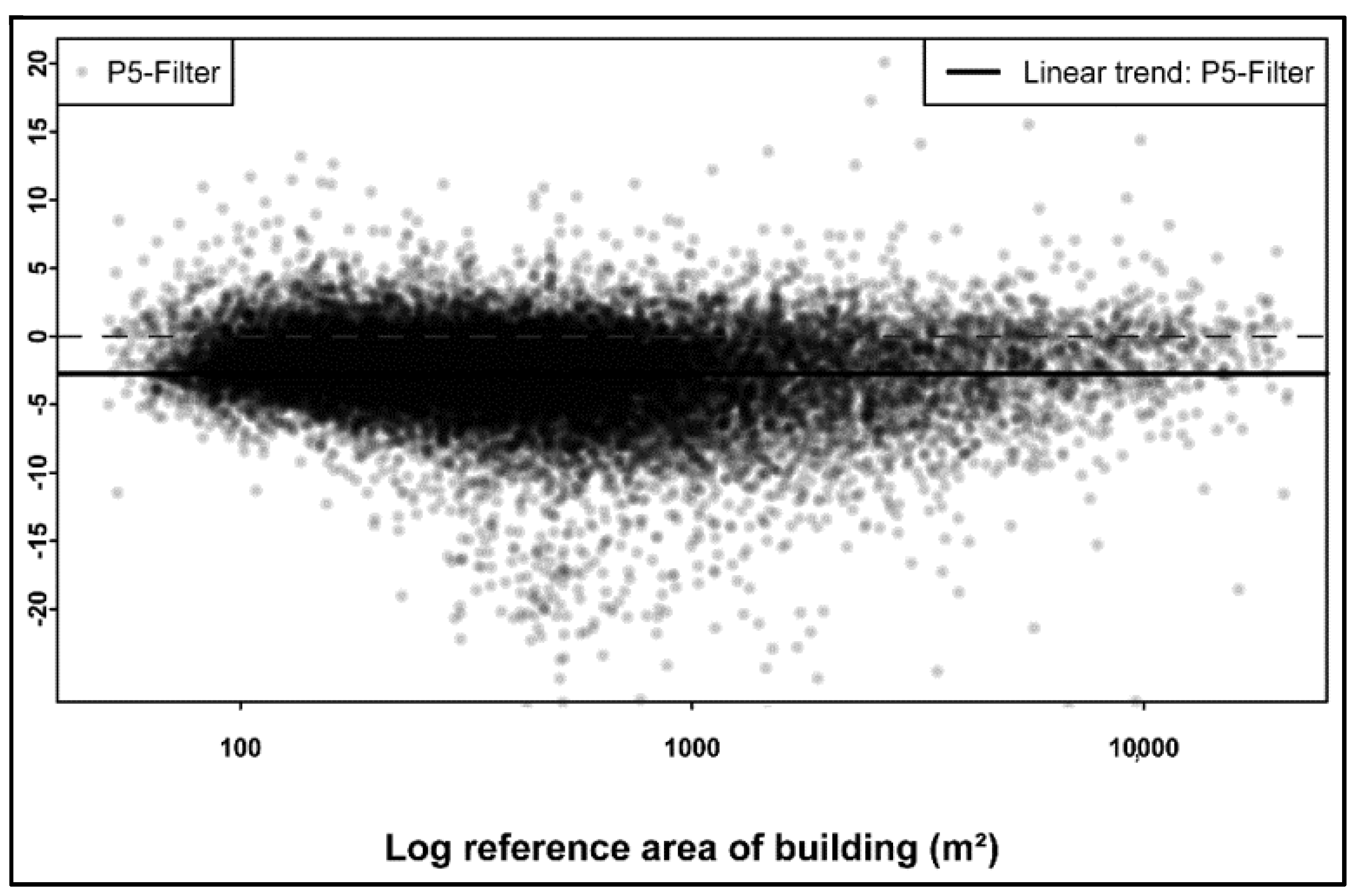
3.1. Remote Sensing-Based Measurement of Built-Up Volume and the Number of Floors
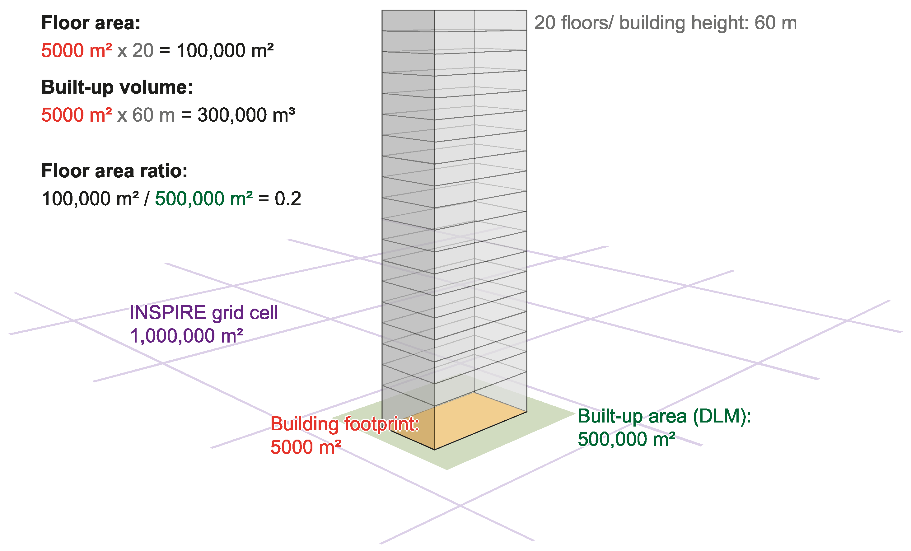
3.2. Derivation of Urban Density per Grid Cell: Built-Up Volume and FAR
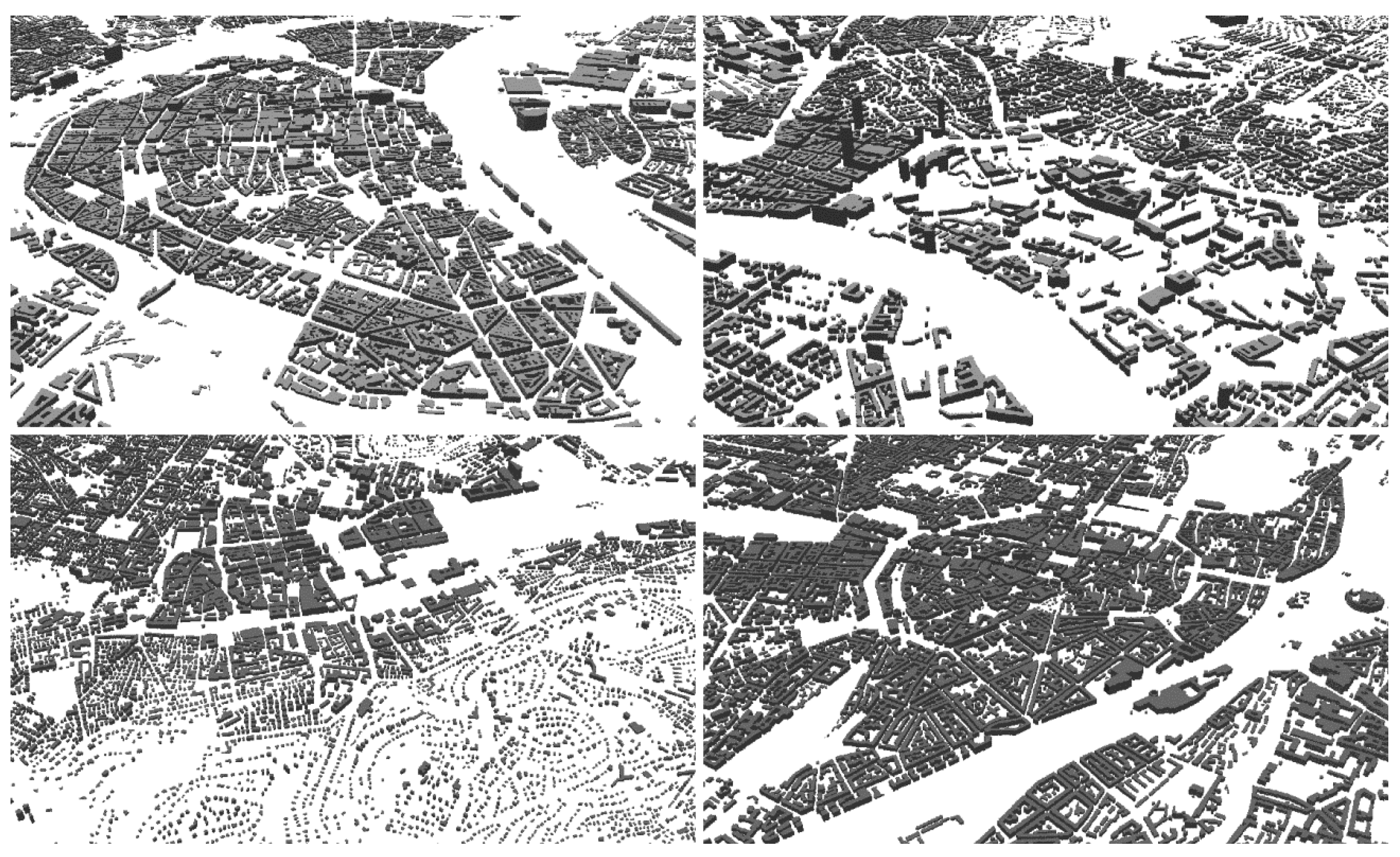
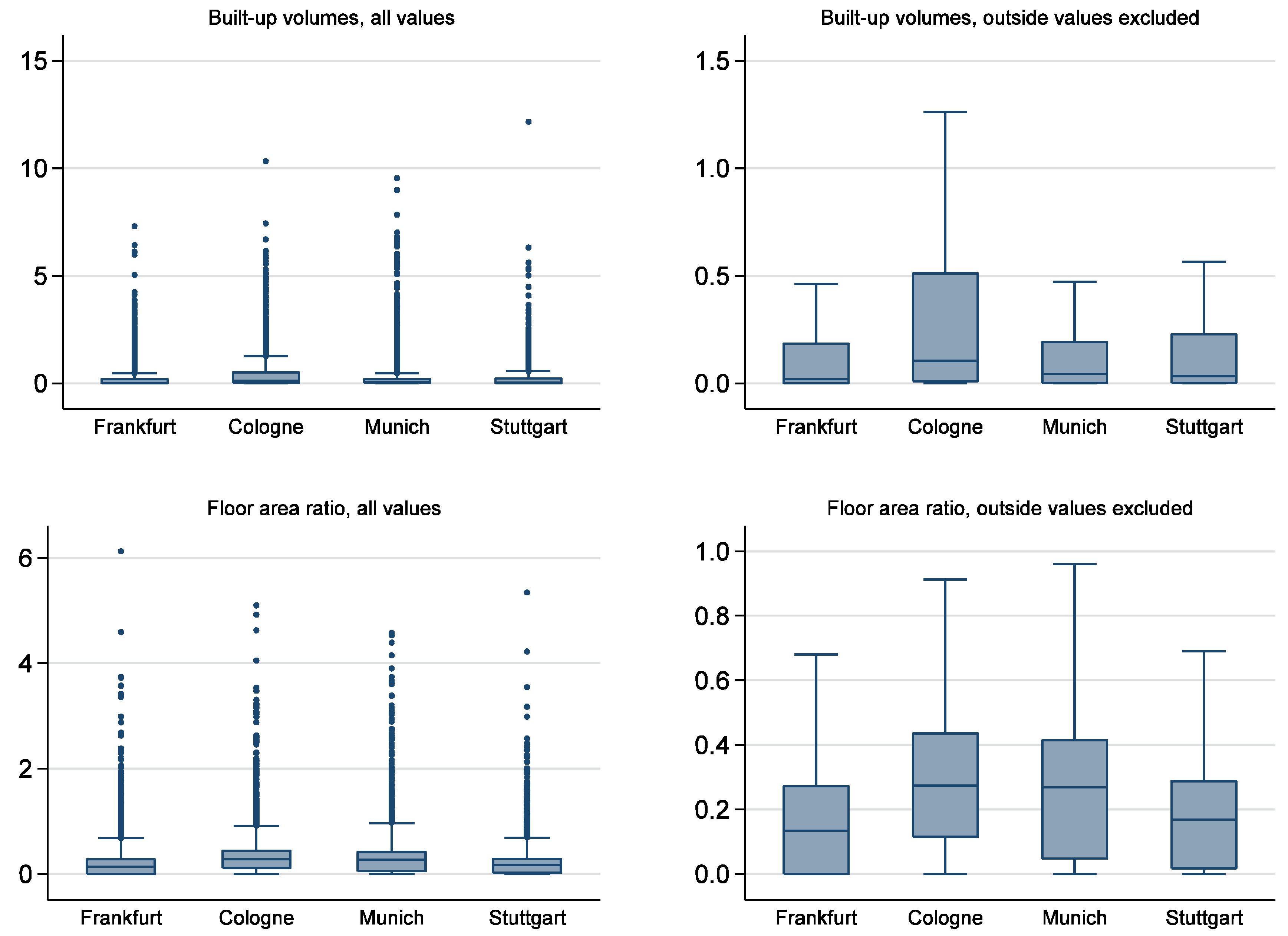
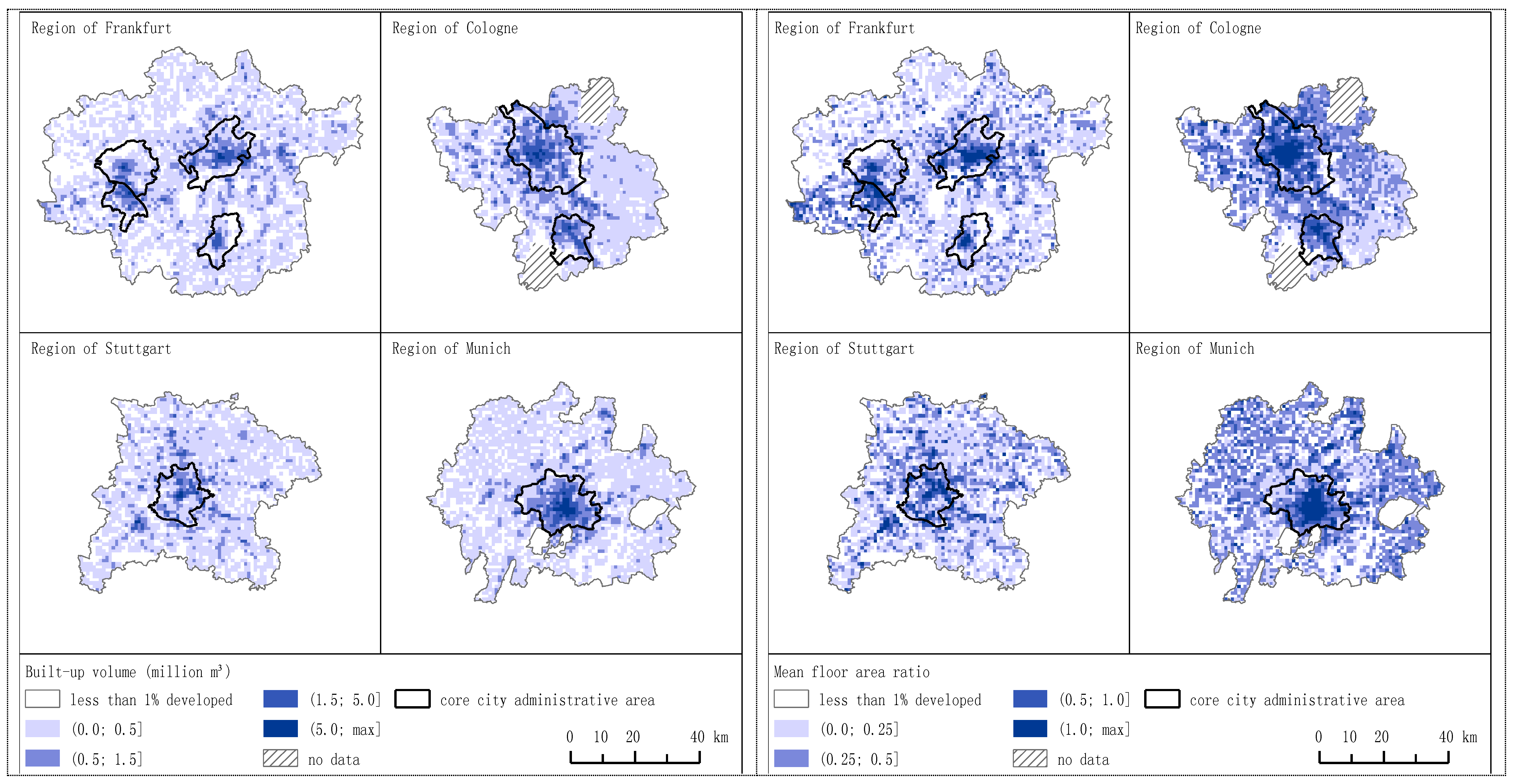
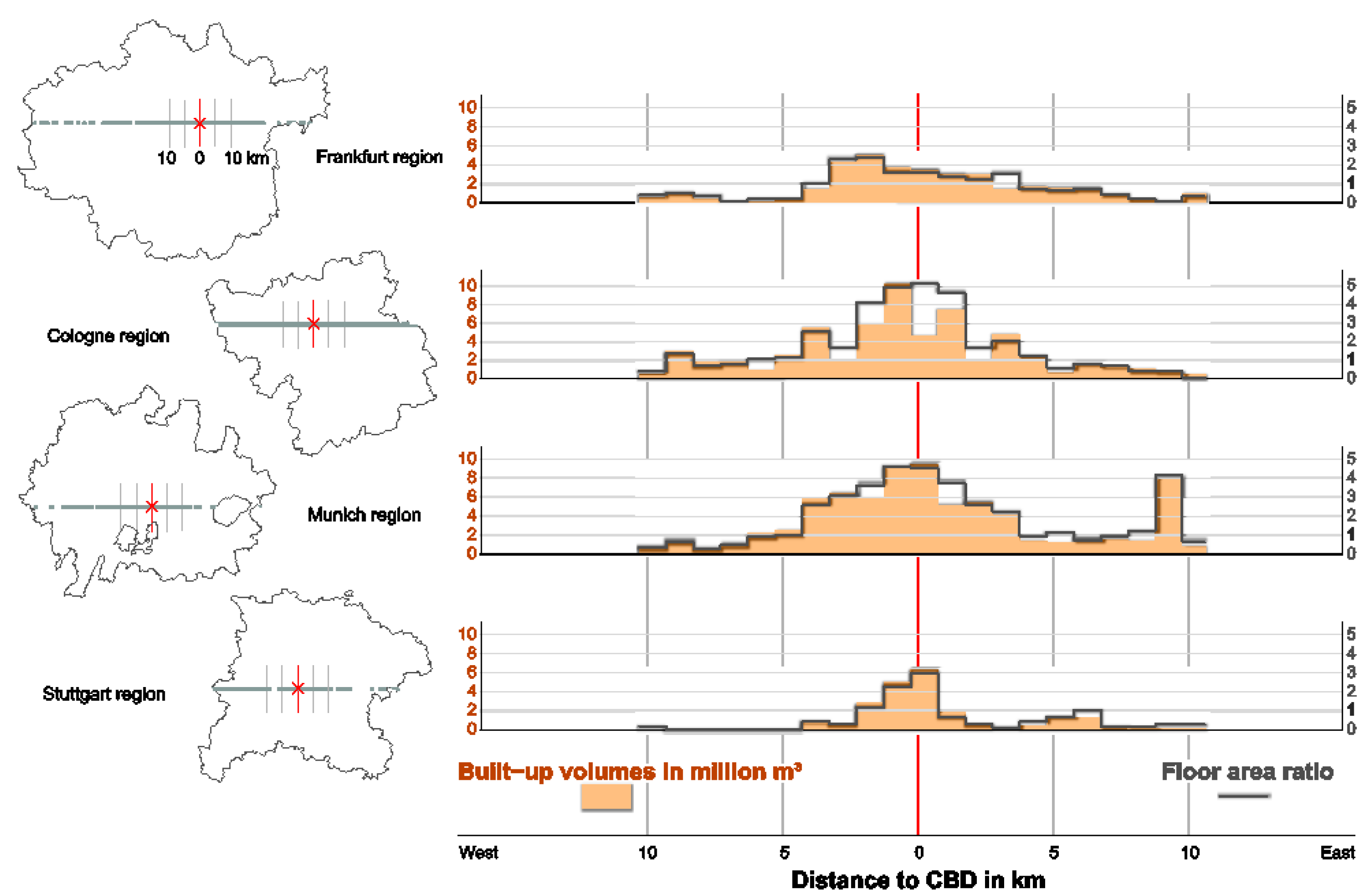
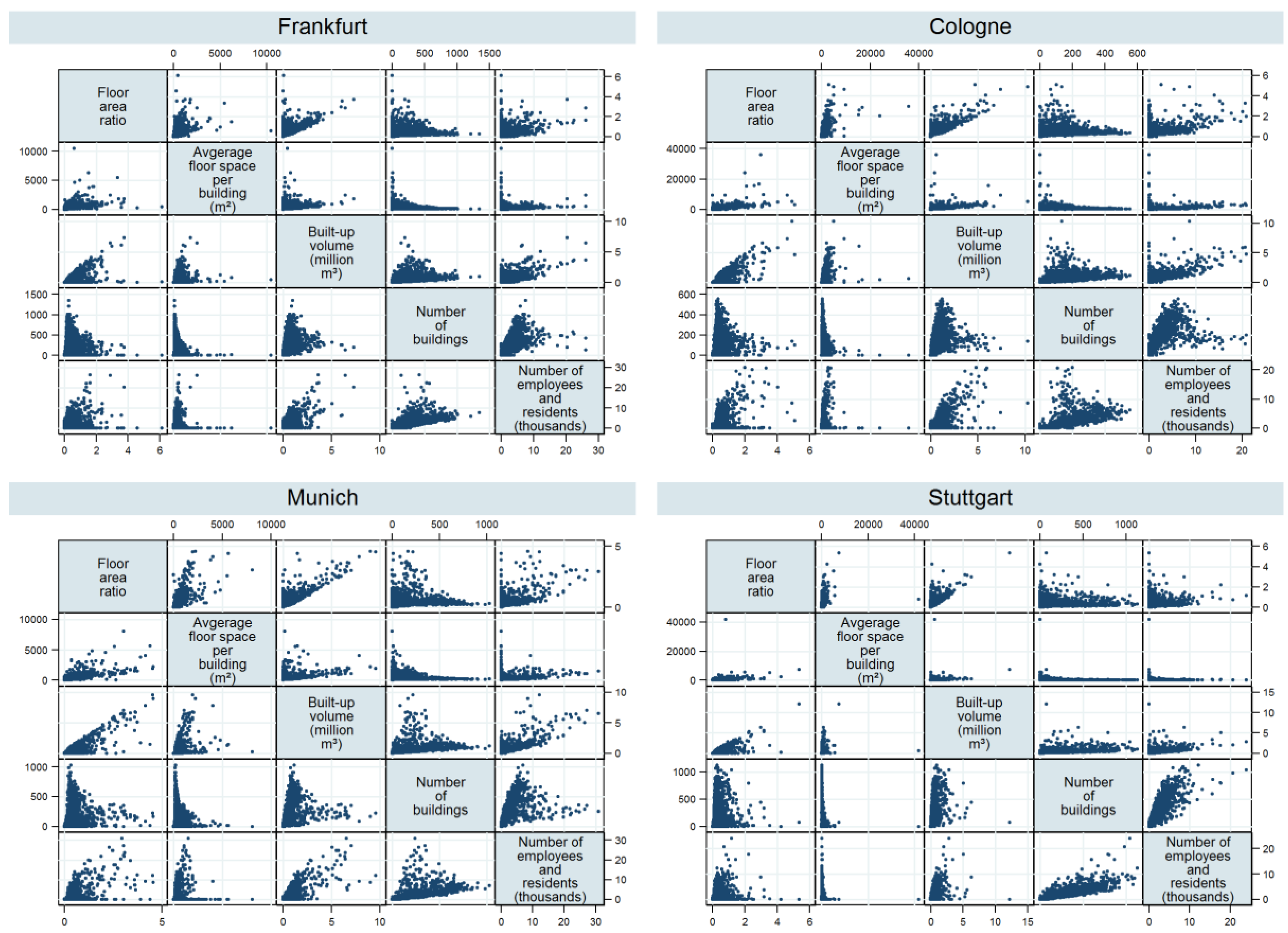
4. Patterns of Built Densities and Their Relation to Activity Densities
5. Discussion
6. Conclusions and Outlook
Acknowledgments
Author Contributions
Conflicts of Interest
Abbreviations
| FAR | floor area ratio |
| IRS | Indian Remote Sensing Satellite |
| DSM | digital surface models |
| BKG | Bundesamt für Kartographie und Geodäsie (Federal Agency for Cartography and Geodesy) |
| INSPIRE | Infrastructure for Spatial Information in the European Community |
| DLM | digital basis landscape model |
| nDSM | normalized DSM |
| DTK25-V | Digitale Topographische Karte 1:25 000, Vorläufige Ausgabe (georeferenced digital topographic maps) |
| LoD1 | Level of Detail 1 |
| WZ 2008 | Klassifikation der Wirtschaftszweige 2008 (Classification of Economic Activities, 2008 edition) |
| FDZ | Forschungsdatenzentrum (Research Data Centre) |
| BA | Bundesagentur für Arbeit (Federal Employment Agency) |
| IAB | Institut für Arbeitsmarkt- und Berufsforschung (Institute for Employment Research) |
References
- Ewing, R.; Hamidi, S. Compactness versus sprawl: A review of recent evidence from the United States. J. Plan. Lit. 2015, 30, 413–432. [Google Scholar] [CrossRef]
- OECD. Compact City Policies: A Comparative Assessment; OECD: Paris, France, 2012. [Google Scholar]
- Churchman, A. Disentangling the concept of density. J. Plan. Lit. 1999, 13, 389–411. [Google Scholar] [CrossRef]
- Roberts, B.H. Changes in urban density: Its implications on the sustainable development of Australian cities. In Proceedings of the State of Australian Cities National Conference, Adelaide, Australia, 28–30 November 2007.
- Acioly, C.; Davidson, F. Density in urban development. Build. Issues 1996, 8, 3–25. [Google Scholar]
- Ewing, R.; Cervero, R. Travel and the built environment. J. Am. Plan. Assoc. 2010, 76, 265–294. [Google Scholar] [CrossRef]
- Ewing, R.; Rong, F. The impact of urban form on U.S. residential energy use. Hous. Policy Debate 2008, 19, 1–30. [Google Scholar] [CrossRef]
- Forsyth, A. Measuring density: Working definitions for residential density and building intensity. Desi. Brief 2003, 8, 1–8. [Google Scholar]
- Forsyth, A.; Oakes, J.M.; Schmitz, K.H.; Hearst, M. Does residential density increase walking and other physical activity? Urban Stud. 2007, 44, 679–697. [Google Scholar] [CrossRef]
- Newman, P.W.G.; Kenworthy, J.R. Gasoline consumption and cities. J. Am. Plan. Assoc. 1989, 55, 24–37. [Google Scholar] [CrossRef]
- OECD. Cities and Climate Change, 1st ed.; OECD: Paris, France, 2010. [Google Scholar]
- Brownstone, D.; Golob, T.F. The impact of residential density on vehicle usage and energy consumption. J. Urban Econ. 2009, 65, 91–98. [Google Scholar] [CrossRef]
- Ewing, R.; Meakins, G.; Hamidi, S.; Nelson, A.C. Relationship between urban sprawl and physical activity, obesity, and morbidity—Update and refinement. Health Place 2014, 26, 118–126. [Google Scholar] [CrossRef] [PubMed]
- Hinde, S.; Dixon, J. Changing the obesogenic environment: Insights from a cultural economy of car reliance. Transp. Res. Part D: Transp. Environ. 2005, 10, 31–53. [Google Scholar] [CrossRef]
- Kelly-Schwartz, A.C.; Stockard, J.; Doyle, S.; Schlossberg, M. Is sprawl unhealthy? A multilevel analysis of the relationship of metropolitan sprawl to the health of individuals. J. Plan. Educ. Res. 2004, 24, 184–196. [Google Scholar] [CrossRef]
- Schläpfer, M.; Lee, J.; Bettencourt, L.M.A. Urban Skylines: Building Heights and Shapes As Measures of City Size. Available online: http://arxiv.org/pdf/1512.00946 (accessed on 11 May 2016).
- Rode, P.; Keim, C.; Robazza, G.; Viejo, P.; Schofield, J. Cities and energy: Urban morphology and residential heat-energy demand. Environ. Plan. B Plan. Des. 2014, 41, 138–162. [Google Scholar] [CrossRef] [Green Version]
- Angel, S.; Blei, A.M. The productivity of American cities: How densification, relocation, and greater mobility sustain the productive advantage of larger U.S. metropolitan labor markets. Cities 2016, 51, 36–51. [Google Scholar] [CrossRef]
- UN Habitat. Urban Patterns for a Green Economy; United Nations Human Settlements Programme: Nairobi, Kenya, 2012. [Google Scholar]
- Bettencourt, L.M.A.; West, G.B. A unified theory of urban living. Nature 2010, 467, 912–913. [Google Scholar] [CrossRef] [PubMed]
- Bettencourt, L.M.A.; Lobo, J.; Helbing, D.; Kühnert, C.; West, G.B. Growth, innovation, scaling, and the pace of life in cities. Proc. Natl. Acad. Sci. USA 2007, 104, 7301–7306. [Google Scholar] [CrossRef] [PubMed]
- Ciccone, A.; Hall, R.E. Productivity and the density of economic activity. Am. Econ. Rev. 1996, 86, 54–70. [Google Scholar]
- Harris, T.F.; Ioannides, Y.M. Productivity and Metropolitan Density; Department of Economics, Tufts University: Medford, MA, USA, 2000. [Google Scholar]
- Krehl, A. Urban spatial structure: An interaction between employment and built-up volumes. Reg. Stud. Reg. Sci. 2015, 2, 289–307. [Google Scholar] [CrossRef]
- Muñiz, I.; Garcia-López, M.-À. The polycentric knowledge economy in Barcelona. Urban Geogr. 2010, 31, 774–799. [Google Scholar] [CrossRef]
- Guillain, R.; Le Gallo, J.; Boiteux-Orain, C. Changes in spatial and sectoral patterns of employment in Ile-de-France, 1978–1997. Urban Stud. 2006, 43, 2075–2098. [Google Scholar] [CrossRef]
- Duranton, G.; Puga, D. From sectoral to functional urban specialisation. J. Urban Econ. 2005, 57, 343–370. [Google Scholar] [CrossRef]
- Siedentop, S.; Schiller, G.; Gutsche, J.-M.; Koziol, M.; Walther, J. Siedlungsentwicklung und Infrastrukturfolgekosten. Bilanzierung und Strategieentwicklung; Bundesamt für Bauwesen und Raumordnung: Bonn, Germany, 2006. [Google Scholar]
- Burchell, R.W.; Mukherji, S. Conventional development versus managed growth: The costs of sprawl. Am. J. Public Health 2003, 93, 1534–1540. [Google Scholar] [CrossRef] [PubMed]
- Doubek, C.; Zanetti, G. Siedlungsstruktur und Öffentliche Haushalte: Gutachten des Österreichischen Instituts für Raumplanung (ÖIR); Österreichisches Institut für Raumplanung: Wien, Austria, 1999. [Google Scholar]
- Melo, P.C.; Graham, D.J.; Levinson, D.; Aarabi, S. Agglomeration, accessibility and productivity: Evidence for large metropolitan areas in the US. Urban Stud. 2016. [Google Scholar] [CrossRef]
- Ahlfeldt, G.M. If Alonso was right: Modeling accessibility and explaining the residential land gradient. J. Reg. Sci. 2011, 51, 318–338. [Google Scholar] [CrossRef]
- Kropp, J.; Holsten, A.; Lissner, T.; Roithmeier, O.; Hattermann, F.; Huang, S.; Rock, J.; Wechsung, F.; Lüttger, A.; Pompe, S.; et al. Klimawandel in Nordrhein-Westfalen—Regionale Abschätzung der Anfälligkeit ausgewählter Sektoren; Potsdam Institut für Klimafolgenforschung: Potsdam, Germany, 2009. [Google Scholar]
- Watkins, R.; Palmer, J.; Kolokotroni, M. Increased temperature and intensification of the urban heat island: Implications for human comfort and urban design. Built Environ. 2007, 33, 85–96. [Google Scholar] [CrossRef]
- Koppe, C.; Kovats, S.; Jendritzky, G.; Menne, B.; Breuer, D.J. Heat Waves: Risks and Responses; Regional Office for Europe, World Health Organization: Copenhagen, Denmark, 2004. [Google Scholar]
- McFarlane, C. The geographies of urban density: Topology, politics and the city. Prog. Hum. Geogr. 2015. [Google Scholar] [CrossRef] [Green Version]
- Patel, R.B.; Burke, T.F. Urbanization—An emerging humanitarian disaster. New Engl. J. Med. 2009, 361, 741–743. [Google Scholar] [CrossRef] [PubMed]
- Barr, J.; Cohen, J.P. The floor area ratio gradient: New York City, 1890–2009. Reg. Sci. Urban Econ. 2014, 48, 110–119. [Google Scholar] [CrossRef]
- Susaki, J.; Kajimoto, M.; Kishimoto, M. Urban density mapping of global megacities from polarimetric SAR images. Remote Sens. Environ. 2014, 155, 334–348. [Google Scholar] [CrossRef] [Green Version]
- Jahn, A.; Hecht, R.; Meinel, G. 3D-Gebäudemodelle: Grundlage siedlungsstruktureller Analysen am Beispiel Sachsens. In Flächennutzungsmonitoring VII: Boden, Flächenmanagement, Analysen und Szenarien; Meinel, G., Schumacher, U., Behnisch, M., Krüger, T., Eds.; Rhombos-Verlag: Berlin, Germany, 2015; pp. 233–243. [Google Scholar]
- Landcom. Residential Density Guide; Landcom: Parramatta, Australia, 2011. [Google Scholar]
- Angel, S. Making Room for a Planet of Cities; Lincoln Institute of Land Policy: Cambridge, MA, USA, 2011. [Google Scholar]
- Siedentop, S.; Fina, S. Who sprawls most? Exploring the patterns of urban growth across 26 European countries. Environ. Plan. A 2012, 44, 2765–2784. [Google Scholar] [CrossRef]
- Taubenböck, H.; Wiesner, M. The spatial network of megaregions—Types of connectivity between cities based on settlement patterns derived from EO-data. Comput. Environ. Urban 2015, 54, 165–180. [Google Scholar] [CrossRef]
- Guérois, M.; Pumain, D. Built-up encroachment and the urban field: A comparison of forty European cities. Environ. Plan. A 2008, 40, 2186–2203. [Google Scholar] [CrossRef]
- Fina, S.; Krehl, A.; Siedentop, S.; Taubenböck, H.; Wurm, M. Dichter dran! Neue Möglichkeiten der Vernetzung von Geobasis-, Statistik- und Erdbeobachtungsdaten zur räumlichen Analyse und Visualisierung von Stadtstrukturen mit Dichteoberflächen und-profilen. Raumforsch. Raumordn. 2014, 72, 179–194. [Google Scholar] [CrossRef]
- Wurm, M.; d’Angelo, P.; Reinartz, P.; Taubenböck, H. Investigating the applicability of Cartosat-1 DEMs and topographic maps to localize large-area urban mass concentration. IEEE J. Sel. Top Appl. 2014, 7, 4138–4152. [Google Scholar] [CrossRef]
- Roskamm, N. Dichte: Eine Transdisziplinäre Dekonstruktion; Diskurse zu Stadt und Raum, 1st ed.; Transcript: Bielefeld, Germany, 2011. [Google Scholar]
- Landeshauptstadt Stuttgart. Stadträumliche Dichte. Flächenbilanz von Wohngebieten in Stuttgart; Landeshauptstadt Stuttgart: Stuttgart, Germany, 2005. [Google Scholar]
- Openshaw, S. The Modifiable Areal Unit Problem; Geo Books: Norwich, UK, 1983. [Google Scholar]
- NRSA. Cartosat-1 Data User’s Handbook. 2006. Available online: http://www.euromap.de/download/P5_data_user_handbook.pdf (accessed on 14 February 2016).
- d’Angelo, P.; Lehner, M.; Krauss, T.; Hoja, D.; Reinartz, P. Towards automated DEM generation from high resolution stereo satellite images. Int. Arch. Photogramm. Remote Sens. Spat. Inf. Sci. 2008, XXXVII, 1137–1143. [Google Scholar]
- Tian, J.; Reinartz, P.; d’Angelo, P.; Ehlers, M. Region-based automatic building and forest change detection on Cartosat-1 stereo imagery. ISPRS J. Photogramm. 2013, 79, 226–239. [Google Scholar] [CrossRef]
- Hirschmuller, H. Stereo processing by semiglobal matching and mutual information. IEEE T Pattern. Anal. 2008, 30, 328–341. [Google Scholar] [CrossRef] [PubMed]
- GeoBasis-DE. Digital Topographic Map 1:25,000, Preliminary Edition. DTK25-V. Available online: http://www.geodatenzentrum.de/docpdf/dtk25-v_eng.pdf (accessed on 17 May 2016).
- Congalton, R.G. A review of assessing the accuracy of classifications of remotely sensed data. Remote Sens. Environ. 1991, 37, 35–46. [Google Scholar] [CrossRef]
- Wurm, M.; Taubenböck, H.; Goebel, J.; Wagner, G.G. At the edge of the city center: discrimination of the physical city center by subjective perception and satellite data. In Proceedings of the 2015 Joint Urban Remote Sensing Event (JURSE), Lausanne, Switzerland, 30 March–1 April 2015.
- Taubenböck, H.; Wurm, M. disP Service: Wo beginnt die Stadt? Urbane Fernerkundung für stadtgeographische Forschung. disP-Plan. Rev. 2015, 51, 78–89. [Google Scholar] [CrossRef]
- Wurm, M.; Taubenböck, H.; Schardt, M.; Esch, T.; Dech, S. Object-based image information fusion using multisensor Earth observation data over urban areas. Int. J. Image Data Fusion 2011, 2, 121–147. [Google Scholar] [CrossRef]
- European Forum for Geography and Statistics. GRID_ETRS89_LAEA_1K. Available online: http://www.efgs.info/data/european-datasets/eurogrid (accessed on 29 January 2016).
- BKG. The Digital Basic Landscape Model (AAA). Available online: http://www.geodatenzentrum.de/docpdf/basis-dlm-aaa_eng.pdf (accessed on 14 February 2016).
- Statistik der Bundesagentur für Arbeit. Sozialversicherungspflichtig Beschäftigte nach Wohn- und Arbeitsort mit Pendlerdaten. Available online: https://Statistik.Arbeitsagentur.De/Statistikdaten/Detail/201012/Iiia6/Sozbe-Gemwoao/Gemwoao-D-0-Xls.Xls (accessed on 20 May 2016).
- Statistische Ämter des Bundes und der Länder. Bevölkerungsstand: Bevölkerung nach Geschlecht-Stichtag 31.12.-regionale Tiefe: Gemeinden, Samt-/Verbandsgemeinden. Table 173-01-5. Available online: https://www.regionalstatistik.de/genesis/online;jsessionid=C447F1580D6891A6425855D54364F85F?sequenz=tabelleErgebnis&selectionname=173-01-5 (accessed on 20 May 2016).
- Krehl, A. Polyzentralität in deutschen Stadtregionen—Eine integrierte Bestandsaufnahme. In Globale Urbanisierung—Perspektive aus dem All; Taubenböck, H., Wurm, M., Esch, T., Dech, S., Eds.; SpringerSpektrum: Berlin, Germany; Heidelberg, Germany, 2015; pp. 159–170. [Google Scholar]
- Siedentop, S.; Krehl, A.; Taubenböck, H.; Wurm, M. Die bauliche Dichte der Stadtregion—Erzeugung kleinräumiger Dichtedaten mit fernerkundlichen Mitteln. In Flächennutzungsmonitoring VI.: Innenentwicklung—Prognose—Datenschutz; Meinel, G., Schumacher, U., Behnisch, M., Eds.; Rhombos: Berlin, Germany, 2014; pp. 179–188. [Google Scholar]
- Scholz, T.; Rauscher, C.; Reiher, J.; Bachteler, T. Geocoding of German Administrative Data: The Case of the Institute for Employment Research; Bundesagentur für Arbeit: Nürnberg, Germany, 2012. [Google Scholar]
- Eurostat. GEOSTAT 2011 Grid Dataset. Available online: http://ec.europa.eu/eurostat/web/gisco/geodata/reference-data/population-distribution-demography (accessed on 4 February 2016).
- Filion, P. Suburban inertia: The Entrenchment of dispersed suburbanism. Int. J. Urban Reg. 2015, 39, 633–640. [Google Scholar] [CrossRef]
- Jessen, J.; Roost, F. Refitting Suburbia: Erneuerung der Stadt des 20. Jahrhunderts in Deutschland und den USA; Jovis: Berlin, Germany, 2015. [Google Scholar]
- Grant, J.L.; Nelson, A.C.; Forsyth, A.; Thompson-Fawcett’s, M.; Blais, P.; Filion, P. The future of the suburbs. Suburbs in transition/The resettlement of America’s suburbs/Suburbs in global context: The challenges of continued growth and retrofitting/Suburban urbanity: Re-envisioning indigenous settlement practices/Toward a new suburban America: Will we catch the wave?/Optimistic and pessimistic perspectives on the evolution of the North American suburb/Response. Plan. Theory Pract. 2013, 14, 391–415. [Google Scholar]
- Dunham-Jones, E.; Williamson, J. Retrofitting Suburbia. Urban Design Solutions for Redesigning Suburbs; John Wiley & Sons Inc.: Hoboken, NJ, USA, 2009. [Google Scholar]
- Harlan, S.L.; Brazel, A.J.; Prashad, L.; Stefanov, W.L.; Larsen, L. Neighborhood microclimates and vulnerability to heat stress. Soc. Sci. Med. 2006, 63, 2847–2863. [Google Scholar] [CrossRef] [PubMed]
- Moss, T. “Cold spots” of urban infrastructure: “Shrinking” processes in Eastern Germany and the modern infrastructural ideal. Int. J. Urban Reg. 2008, 32, 436–451. [Google Scholar] [CrossRef]
- Schiller, G.; Siedentop, S. Infrastrukturfolgekosten der siedlungsentwicklung unter schrumpfungsbedingungen. disP-Plan. Rev. 2005, 41, 83–93. [Google Scholar] [CrossRef]


| Indicator | Scale | Meaning/Measurement | Included Land Resources |
|---|---|---|---|
| Metropolitan density | Region | People, jobs or dwelling units per land area unit | Administrative area |
| Urban (residential) density | City, city district | People, jobs or dwelling units per land area unit | Urbanized area |
| Gross residential density | Neighborhood, urban block | People or dwelling units per land area unit | Residential area (including streets, pavements, local community services and public open spaces) |
| Net residential density | Neighborhood, urban block | People or dwelling units per land area unit | Residential area (not including streets, local community services public open spaces) |
| Site density | Plot, property | Dwelling units per land area unit; floor area per land area unit | Single plot, property |
| Occupation density | Dwelling unit | People per dwelling unit | Single dwelling unit |
| (Source: own compilation based on information and definitions provided in [3,41]) | |||
| Indicator | City Region | |||
|---|---|---|---|---|
| Cologne | Frankfurt | Munich | Stuttgart | |
| Area (km2) | 2812 | 4843 | 3277 | 2842 |
| Population (million residents) | 2.81 | 3.57 | 2.43 | 2.40 |
| Employment (million jobs) | 0.99 | 1.46 | 1.09 | 0.96 |
| Built-up area (km2) | 623 | 807 | 535 | 505 |
| Built-up volume (million m3) | 1159 | 1029 | 942 | 659 |
| Floor area (km2) | 374 | 335 | 328 | 216 |
| Population density (people per km2) | 1000 | 736 | 742 | 845 |
| Mean floor area ratio (FAR) | 0.60 | 0.41 | 0.61 | 0.43 |
| Floor area per resident and job (m2) | 99 | 67 | 93 | 64 |
| Built-up volume per resident and job (m3) | 305 | 205 | 268 | 197 |
| City Region | ||||
|---|---|---|---|---|
| Cologne | Frankfurt | Munich | Stuttgart | |
| Floor area ratio (FAR) | ||||
| Average floor space per building | 0.69 | 0.61 | 0.62 | 0.55 |
| Built-up volume | 0.70 | 0.66 | 0.53 | 0.66 |
| Number of buildings | 0.41 | 0.39 | 0.30 | 0.38 |
| Number of residents and employees | 0.43 | 0.38 | 0.33 | 0.38 |
| Number of residents and employees | ||||
| Floor area ratio (FAR) | 0.43 | 0.38 | 0.33 | 0.38 |
| Average floor space per building | 0.27 | / | / | −0.06 |
| Built-up volume | 0.82 | 0.83 | 0.88 | 0.86 |
| Number of buildings | 0.90 | 0.92 | 0.95 | 0.95 |
© 2016 by the authors; licensee MDPI, Basel, Switzerland. This article is an open access article distributed under the terms and conditions of the Creative Commons Attribution (CC-BY) license (http://creativecommons.org/licenses/by/4.0/).
Share and Cite
Krehl, A.; Siedentop, S.; Taubenböck, H.; Wurm, M. A Comprehensive View on Urban Spatial Structure: Urban Density Patterns of German City Regions. ISPRS Int. J. Geo-Inf. 2016, 5, 76. https://doi.org/10.3390/ijgi5060076
Krehl A, Siedentop S, Taubenböck H, Wurm M. A Comprehensive View on Urban Spatial Structure: Urban Density Patterns of German City Regions. ISPRS International Journal of Geo-Information. 2016; 5(6):76. https://doi.org/10.3390/ijgi5060076
Chicago/Turabian StyleKrehl, Angelika, Stefan Siedentop, Hannes Taubenböck, and Michael Wurm. 2016. "A Comprehensive View on Urban Spatial Structure: Urban Density Patterns of German City Regions" ISPRS International Journal of Geo-Information 5, no. 6: 76. https://doi.org/10.3390/ijgi5060076
APA StyleKrehl, A., Siedentop, S., Taubenböck, H., & Wurm, M. (2016). A Comprehensive View on Urban Spatial Structure: Urban Density Patterns of German City Regions. ISPRS International Journal of Geo-Information, 5(6), 76. https://doi.org/10.3390/ijgi5060076