
Experimental Evaluation of the Usability of Cartogram for Representation of GlobeLand30 Data


Abstract
:1. Introduction
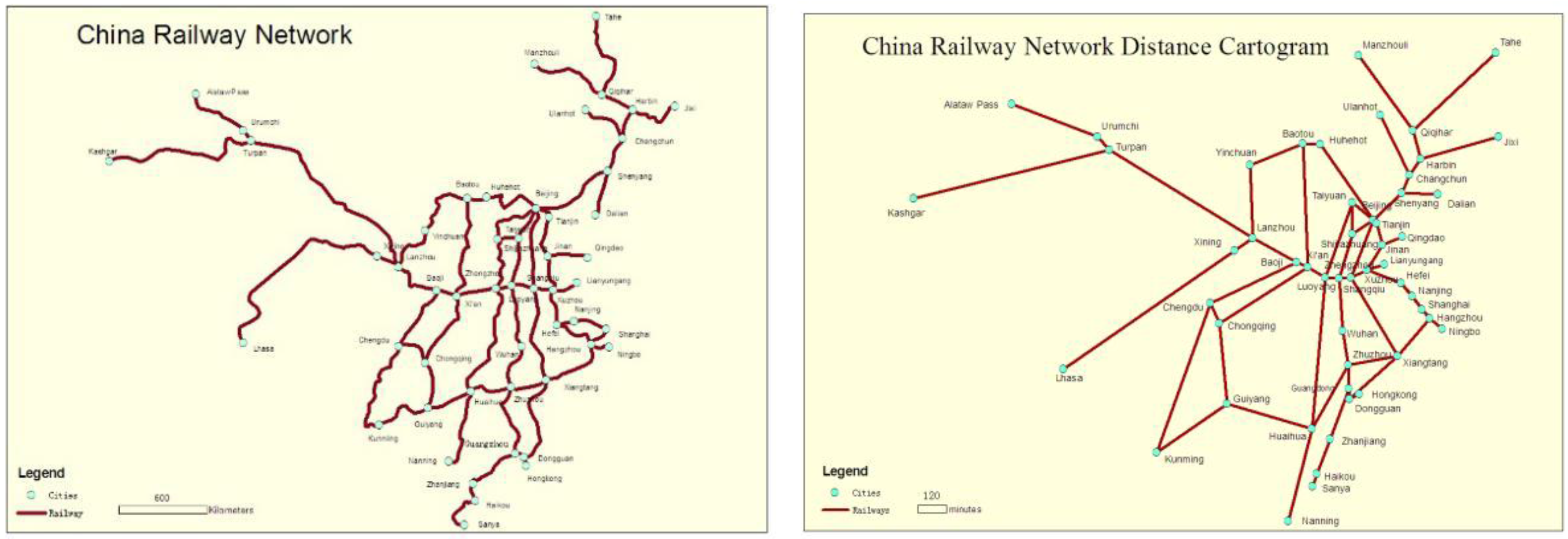
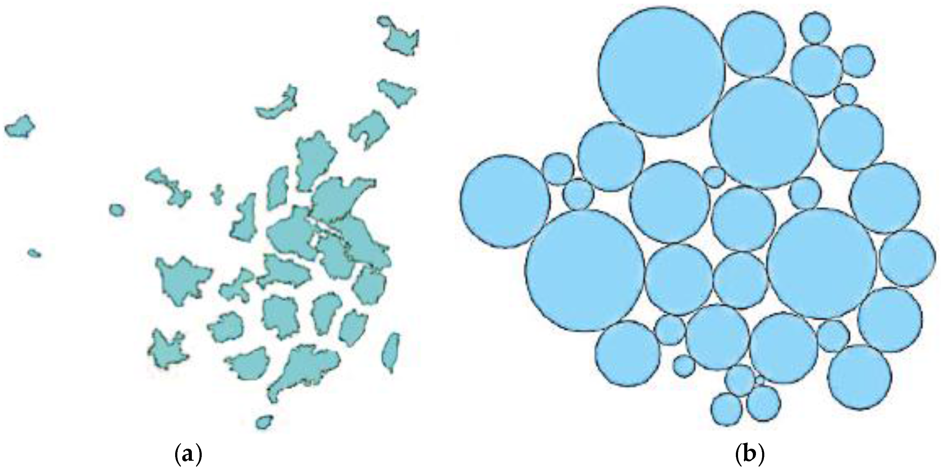
2. Selection of Cartogram for Study
3. Design of Experiments
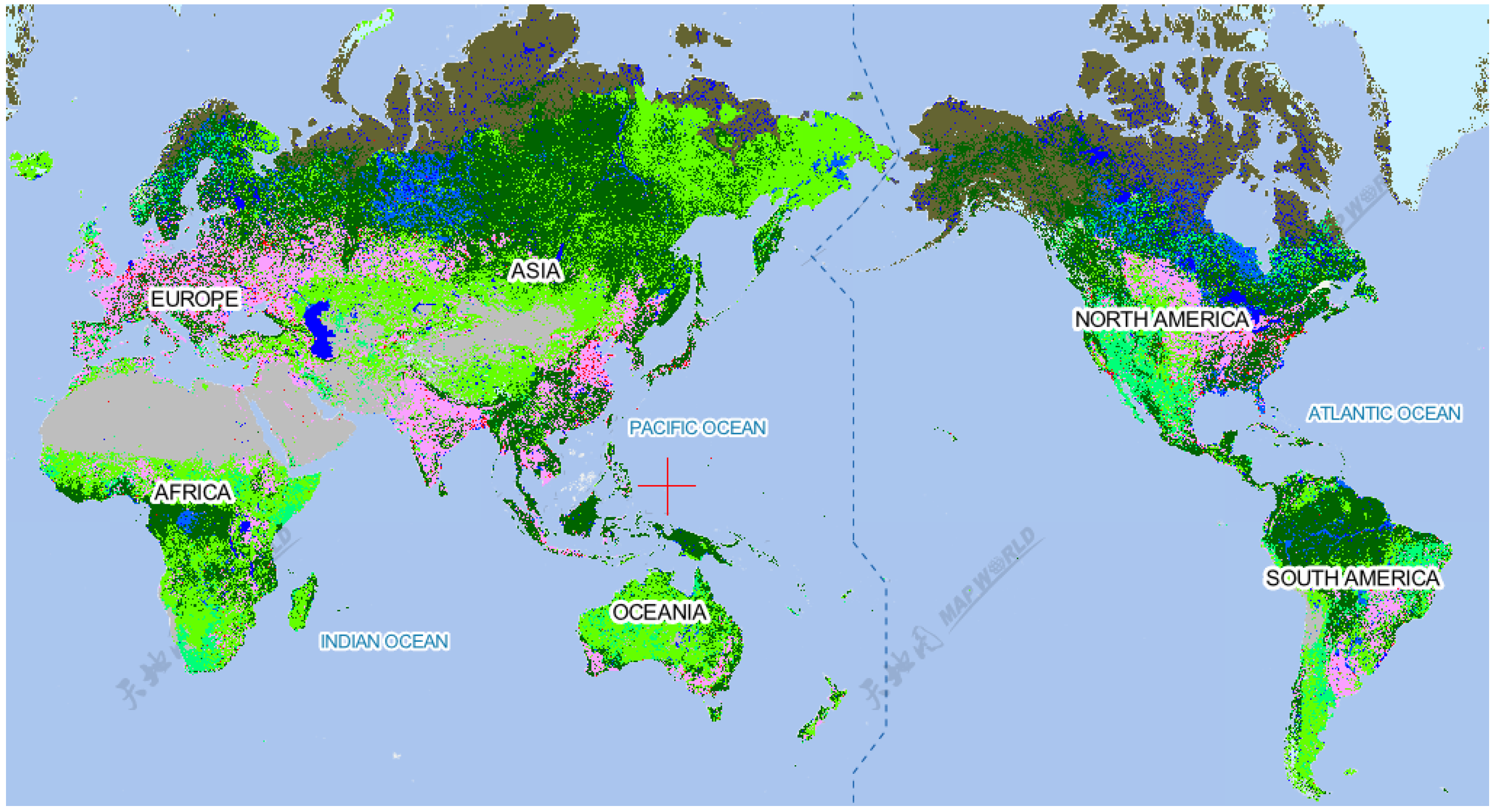
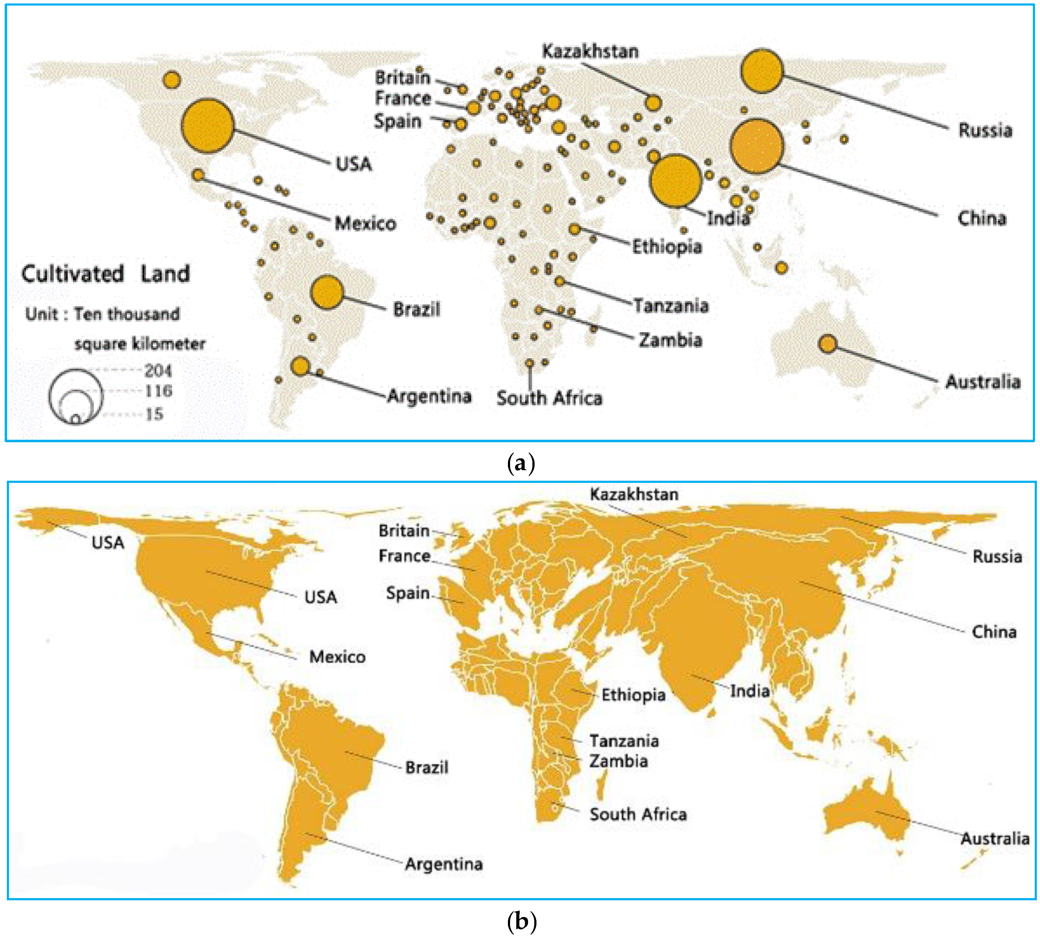
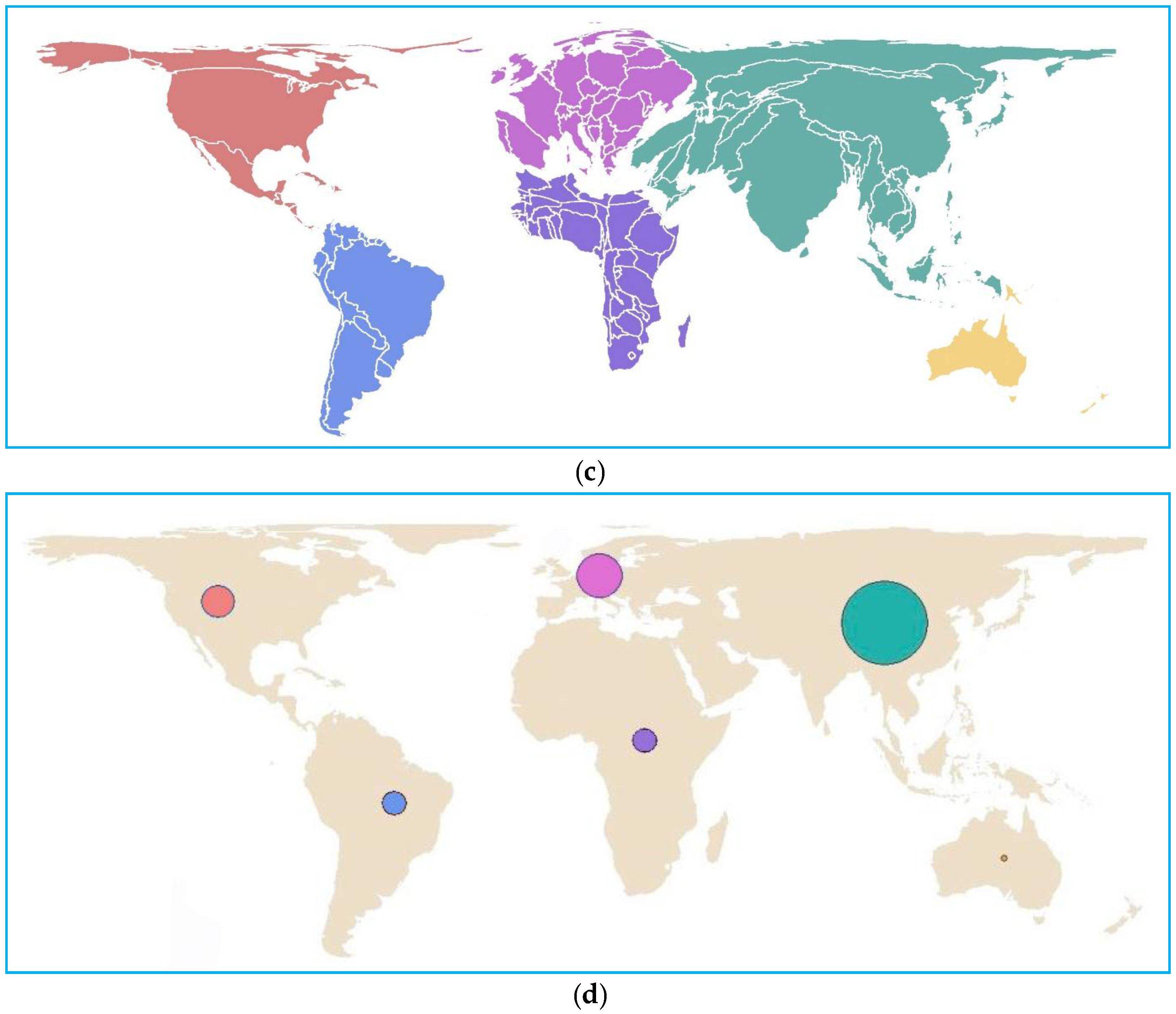
3.1. Source Data, Measures and Reference Maps
3.2. Hypothesis and Quantitative Analyses
3.3. Experiments
4. Usability of Cartograms for GlobeLand30: Comparison with Proportional Symbol Maps
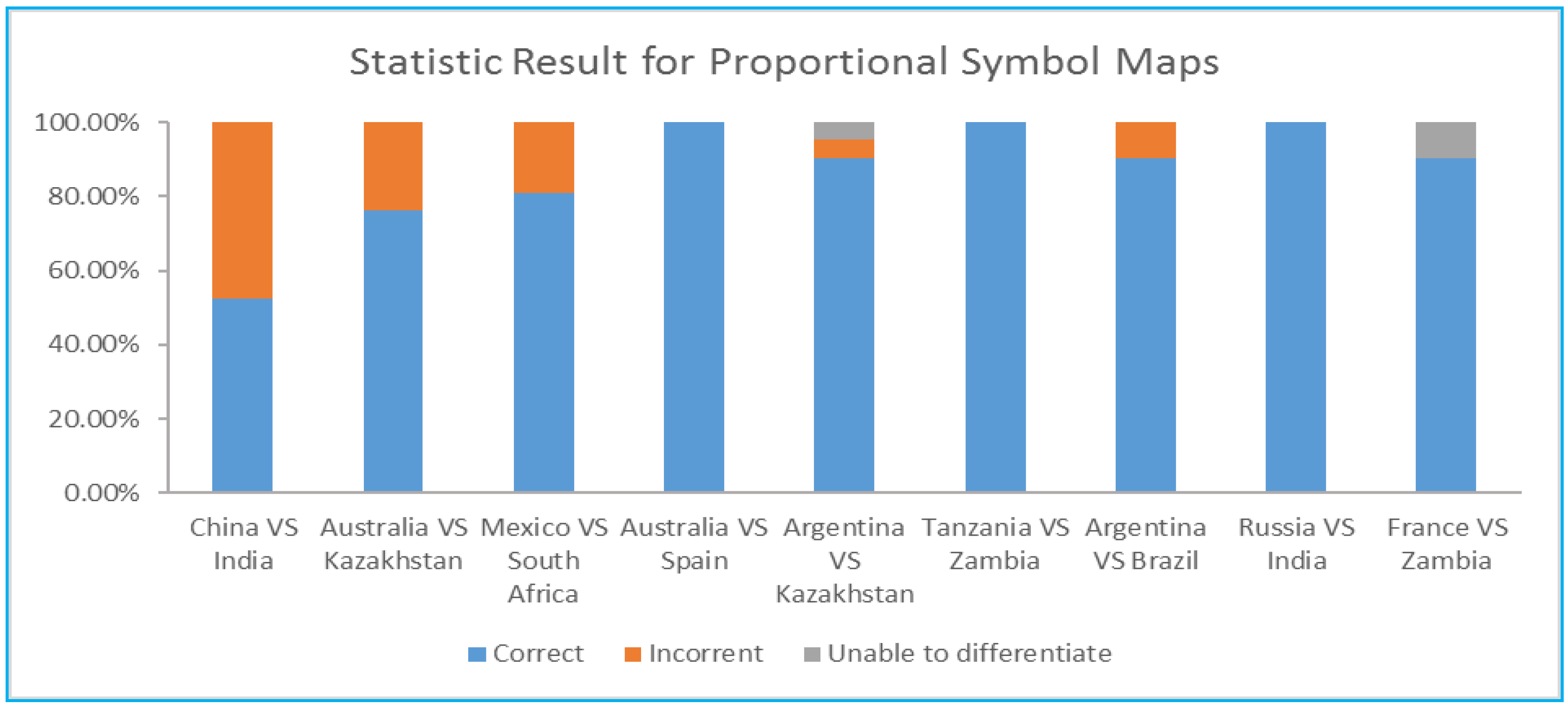
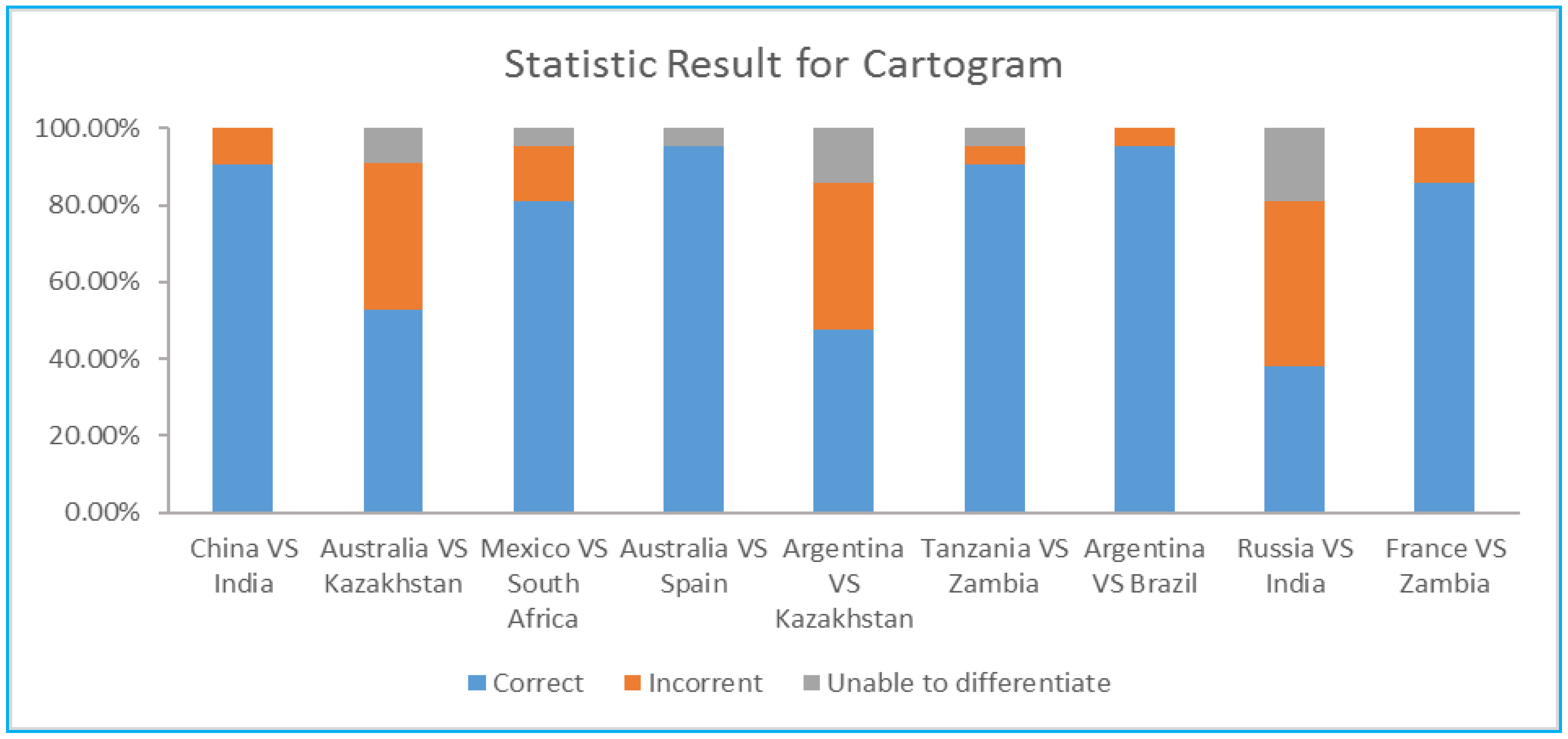
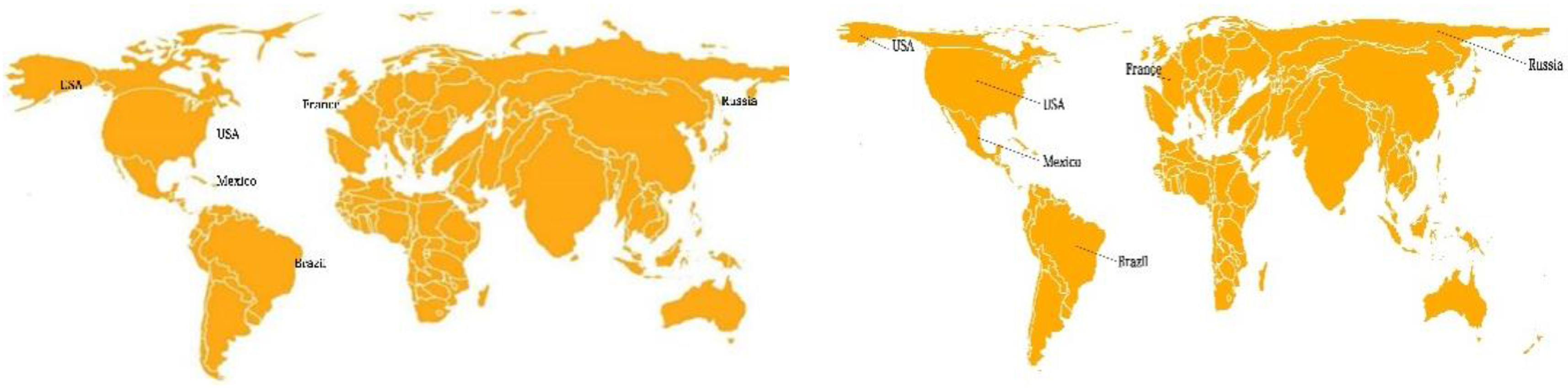
4.1. Usability in the Recognition of the Equality or Inequality of Quantities
- Small differences: China vs. India, Australia vs. Kazakhstan, Mexico vs. South Africa;
- Medium differences: Australia vs. Spain, Argentina vs. Kazakhstan, Tanzania vs. Zambia;
- Large differences: Argentina vs. Brazil, Russia vs. India, France vs. Zambia.
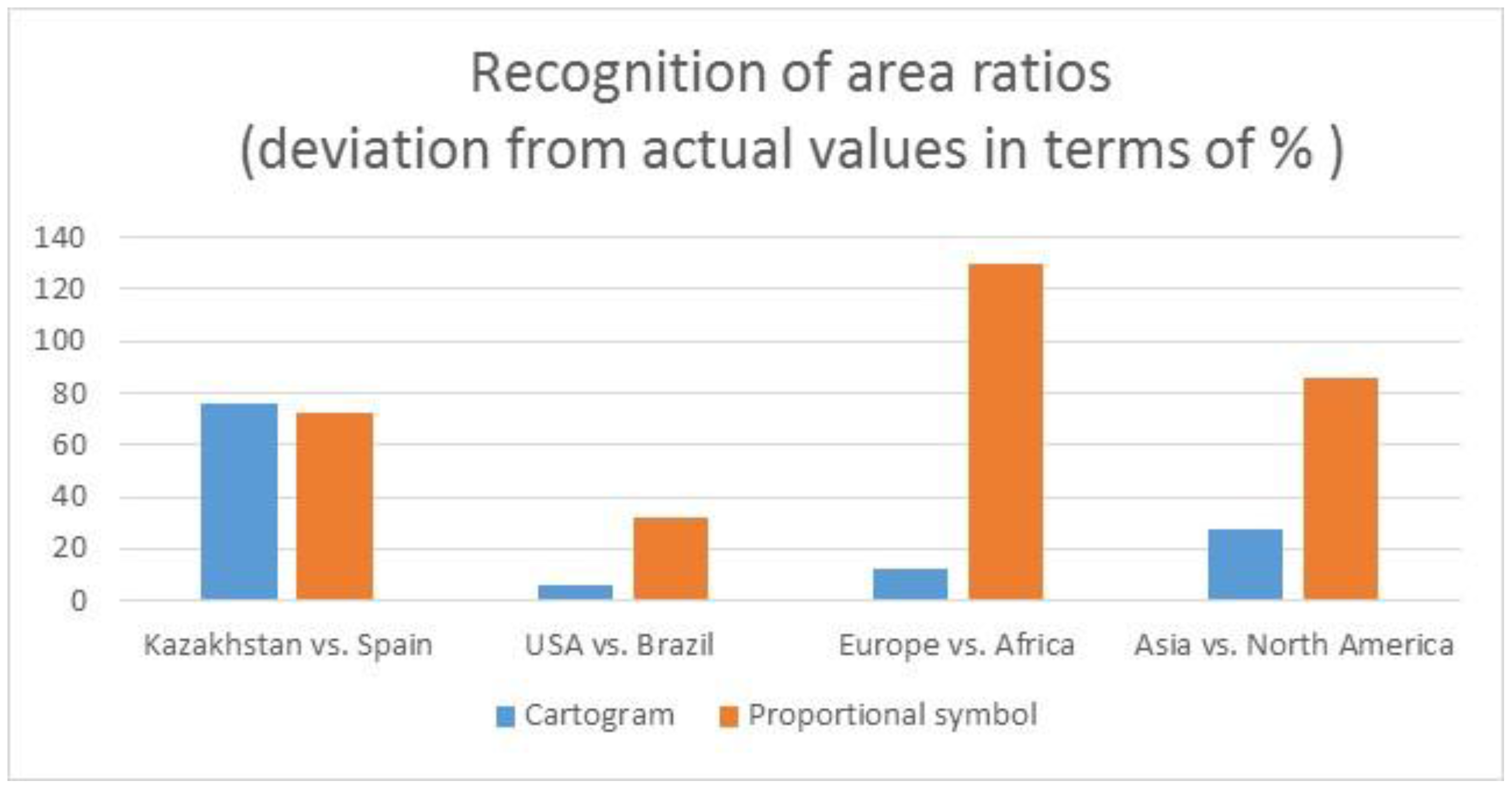
4.2. Usability in the Recognition of the Ratio Relation between Quantities
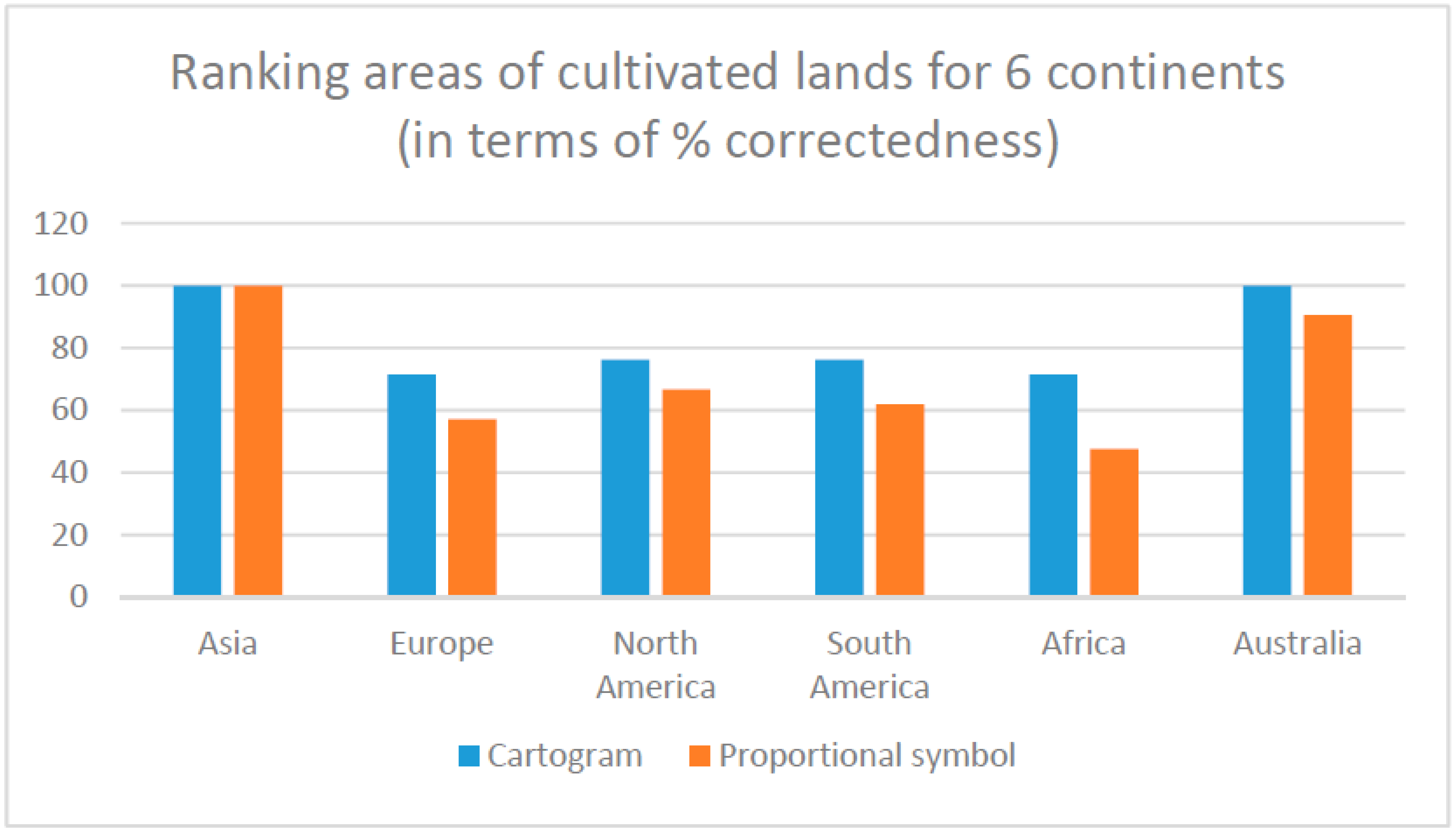
4.3. Usability in the Recognition of Quantity Distributions
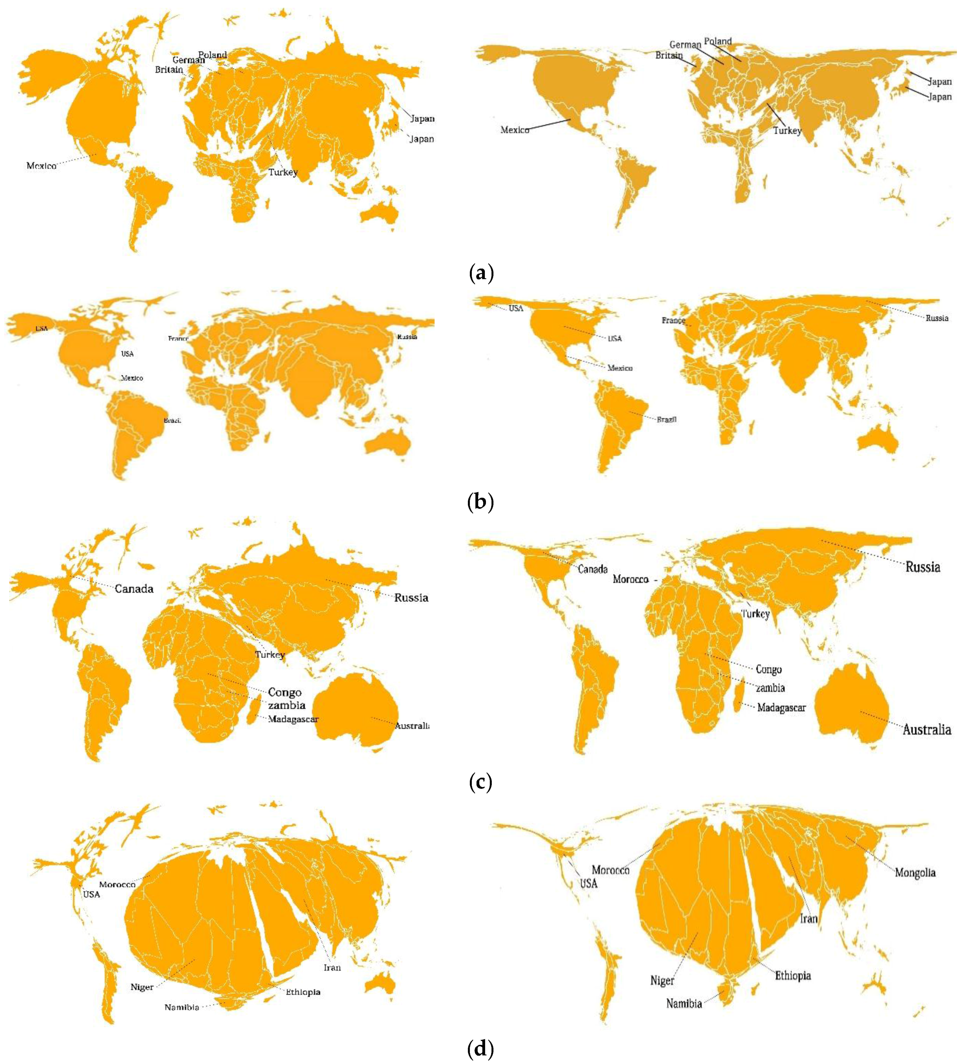
5. Usability of Cartograms for GlobeLand30: Impact of Map Projection Type
6. Conclusions
- when comparing size inequality at the country level, cartograms are less effective;
- when comparing the area ratio and size inequality at the continental level, cartograms perform better in terms of all three usability measures;
- the usability of cartograms is greatly affected by the (shape) irregularity of the area units;
- in terms of map reading efficiency, there was no significant difference found between the two map types; and
- in terms of satisfaction, the opinions were also diverse, but more people preferred cartograms.
Acknowledgments
Author Contributions
Conflicts of Interest
References
- Chen, Ju.; Chen, Ji.; Liao, A.; Cao, X.; Chen, L.; Chen, X.; He, C.; Han, G.; Peng, S.; Lu, M.; et al. Global land cover mapping at 30m resolution: A POK-based operational approach. ISPRS J. Photogramm. Remote Sens. 2015, 103, 7–27. [Google Scholar] [CrossRef]
- Kocmoud, C.J.; House, D.H. A Constraint-based Approach to Constructing Contiguous Cartograms. In Proceedings of the 8th International Symposium on Spatial Data Handing, Vancouver, BC, Canada, 11–15 July 1998. [Google Scholar]
- Sun, H.; Li, Z.L. Effectiveness of Cartogram for the representation of spatial data. Cartogr. J. 2010, 47, 12–21. [Google Scholar] [CrossRef]
- Inoue, R.; Shimizu, E. A new algorithm for continuous area cartogram construction with triangulation of regions and restriction on bearing changes of edges. Cartogr. Geogr. Inf. Sci. 2006, 33, 115–125. [Google Scholar] [CrossRef]
- Tobler, W. Thirty five years of computer Cartograms. Ann. Assoc. Am. Geogr. 2004, 94, 58–73. [Google Scholar] [CrossRef]
- Tao, M. Using Cartograms in Disease Mapping. Ph.D. Thesis, The University of Sheffield, Sheffield, UK, 2010. [Google Scholar]
- Friis, H. Statistical cartography in the United States prior to1870 and the role of Joseph C. G. Kennedy and the U.S. Census Office. Am. Cartogr. 1974, 1, 131–157. [Google Scholar] [CrossRef]
- Wolf, E.B. Creating contiguous cartograms in ArcGIS 9. In Proceedings of the 2005 ESRI International User Conference, San Diego, CA, USA, 25–29 July 2005. [Google Scholar]
- Tang, F.Q. A Comparative Study of Various Travel Time Representation Approaches for a Road Network. Master’s Thesis, The Hong Kong Polytechnic University, Hong Kong, 2012. [Google Scholar]
- Krauss, M.R.D. The Relative Effectiveness of the Noncontiguous Cartogram. Master’s Thesis, Virginia Polytechnic Institute and State University, Blackbrug, VA, USA, 1989. [Google Scholar]
- Tobler, W. A continuous transformation useful for districting. Ann. N. Y. Acad. Sci. 1973, 219, 215–220. [Google Scholar] [CrossRef] [PubMed]
- Selvin, S.D.; Sacks, M.S.; Bedell, L.W.; Schulman, J. Transformations of Maps to Investigate Clusters of Disease; No. LBL-18550; University of California: Berkeley, CA, USA, 1984. [Google Scholar]
- Dougenik, J.A.; Chrisman, N.R.; Niemeyer, D.R. An algorithm to construct continuous area cartograms. Prof. Geogr. 1985, 37, 75–81. [Google Scholar] [CrossRef]
- Torguson, J.S. Cartogram: A Microcomputer Program for the Interactive Construction of Value-by-Area Cartograms. Master’s Thesis, University of Georgia, Athens, GA, USA, 1990. [Google Scholar]
- Gusein-Zade, S.M.; Tikunov, V. A new technique for constructing contiguous cartogram. Cartogr. Geogr. Inf. Syst. 1993, 20, 167–173. [Google Scholar] [CrossRef]
- Gastner, M.T.; Newman, M.E.J. Diffusion-based method for producing density-equalizing maps. Proc. Natl. Acad. Sci. USA 2004, 101, 7499–7504. [Google Scholar] [CrossRef] [PubMed]
- Dorling, D. Area Cartograms: Their Use and Creation; Concepts and Techniques in Modern Geography Series No. 59; University of East Anglia: Norwich, UK, 1996. [Google Scholar]
- Brunsdon, C.; Charlton, M. Spoilt for Choice? An Investigation into Creating Gastner and Newman-style Cartograms. In Proceedings of the GIS Research UK 23rd Annual Conference, Leeds, UK, 15–17 April 2015; University of Leeds: Leeds, UK, 2015. [Google Scholar]
- Kreveld, M.V.; Speckmann, B. On rectangular cartogram. Comput. Geom. 2006, 37, 175–187. [Google Scholar] [CrossRef]
- Wikipedia 2008. Cartogram. Available online: http://en.wikipedia.org/wiki/Cartogram (accessed on 27 April 2016).
- Stevens, J.; Smith, J.M.; Bianchetti, R.A. Mapping Our Changing World; MacEachren, A.M., Peuquet, D.J., Eds.; Department of Geography, The Pennsylvania State University: University Park, PA, USA, 2012. [Google Scholar]
- Roth, R.E. An empirically-derived taxonomy of interaction primitives for interactive cartography and geovisualization. IEEE Trans. Vis. Comput. Graph. 2013, 19, 2356–2365. [Google Scholar] [CrossRef] [PubMed]


| Countries for Comparison | Actual Relations | Proportional Symbol Maps | Cartograms | ||||
|---|---|---|---|---|---|---|---|
| Correct | Incorrect | Unable | Correct | Incorrect | Unable | ||
| China vs. India | > | 52.38% | 0.00% | 47.62% | 90.48% | 0.00% | 9.52% |
| Australia vs. Kazakhstan | > | 76.19% | 0.00% | 23.81% | 52.38% | 9.52% | 38.10% |
| Mexico vs. South Africa | > | 80.95% | 0.00% | 19.05% | 80.95% | 4.76% | 14.29% |
| Australia vs. Spain | > | 100.0% | 0.00% | 0.00% | 95.24% | 4.76% | 0.00% |
| Argentina vs. Kazakhstan | > | 90.48% | 4.76% | 4.76% | 47.62% | 14.92% | 38.1% |
| Tanzania vs. Zambia | > | 100.0% | 0.00% | 0.00% | 90.48% | 4.76% | 4.76% |
| Argentina vs. Brazil | < | 90.48% | 0.00% | 9.52% | 95.24% | 0.00% | 4.76% |
| Russia vs. India | < | 100.0% | 0.00% | 0.00% | 38.1% | 19.5% | 42.86% |
| France vs. Zambia | > | 90.48% | 9.52% | 0.00% | 85.71% | 0.00% | 14.29% |
| Regions for Comparison | Actual Ratio | Cartograms | Proportional Symbol Maps | ||||
|---|---|---|---|---|---|---|---|
| Range | Average | Deviation | Range | Average | Deviation | ||
| Kazakhstan vs. Spain | ≅1× | 1–3× | 1.76× | 76.00% | 1–3× | 1.72× | 72.00% |
| USA vs. Brazil | 1.7× | 1–5× | 1.59× | 6.47% | 1–6× | 2.25× | 32.35% |
| Europe vs. Africa | 1.7× | 1–2× | 1.65× | 11.76% | 2–6× | 3.91× | 130.0% |
| Asia vs. North America | 2.6× | 1–3× | 1.87× | 28.08% | 3–8× | 4.84× | 86.15% |
| Actual Ranking | 1 | 2 | 3 | 4 | 5 | 6 |
|---|---|---|---|---|---|---|
| Continent | Asia | Europe | North America | South America | Africa | Australia |
| Proportional symbol map | 100.00% | 57.14% | 66.67% | 61.90% | 47.62% | 90.48% |
| Cartogram | 100.00% | 71.43% | 76.19% | 76.19% | 71.43% | 100.00% |
| Actual Relationship | Equal-Area Projection | Equidistant Projection | |
|---|---|---|---|
| USA vs. Russia | > | 61.9% | 61.6% |
| Brazil vs. Canada | > | 90.2% | 33.3% |
| France vs. Mexico | < | 76.19% | 42.86% |
| Land Type | Country Pair | Equal-Area Projection | Equidistance Projection |
|---|---|---|---|
| Artificial Land | Poland vs. Japan | 61.9% | 71.43% |
| Britain vs. Turkey | 42.86% | 66.67% | |
| German vs. Mexico | 71.43% | 66.67% | |
| Grassland | Australia vs. Russia | 47.62% | 47.62% |
| Congo vs. Canada | 47.62% | 33.33% | |
| Central African Republic vs. Zambia | 71.43% | 47.62% | |
| Water | India vs. Congo | 47.62% | 66.67% |
| Mongolia vs. Zambia | 33.33% | 38.81% | |
| Turkmenistan vs. Mexico | 71.43% | 71.43% | |
| Bare Land | Niger vs. Iran | 42.86% | 14.29% |
| USA vs. Morocco | 90.48% | 76.19% | |
| Nigeria vs. Namibia | 66.67% | 42.86% |
© 2017 by the authors. Licensee MDPI, Basel, Switzerland. This article is an open access article distributed under the terms and conditions of the Creative Commons Attribution (CC BY) license (http://creativecommons.org/licenses/by/4.0/).
Share and Cite
Han, R.; Li, Z.; Ti, P.; Xu, Z. Experimental Evaluation of the Usability of Cartogram for Representation of GlobeLand30 Data. ISPRS Int. J. Geo-Inf. 2017, 6, 180. https://doi.org/10.3390/ijgi6060180
Han R, Li Z, Ti P, Xu Z. Experimental Evaluation of the Usability of Cartogram for Representation of GlobeLand30 Data. ISPRS International Journal of Geo-Information. 2017; 6(6):180. https://doi.org/10.3390/ijgi6060180
Chicago/Turabian StyleHan, Rui, Zhilin Li, Peng Ti, and Zhu Xu. 2017. "Experimental Evaluation of the Usability of Cartogram for Representation of GlobeLand30 Data" ISPRS International Journal of Geo-Information 6, no. 6: 180. https://doi.org/10.3390/ijgi6060180