A Critical Review of the Integration of Geographic Information System and Building Information Modelling at the Data Level
Abstract
1. Introduction
2. Building Information Modelling (BIM) and Geographic Information System (GIS)
2.1. Differences and Similarities between BIM and GIS
2.2. Drivers for Integration
3. Integration of BIM and GIS
3.1. Levels of Integration
3.2. Typical Data Formats Involved
3.2.1. Industry Foundation Classes (IFC)
3.2.2. City Geography Markup Language (CityGML)
3.2.3. Formats for Integration
3.3. Data Interoperability
3.3.1. Geometry Level
3.3.2. Semantic Level
4. Discussion
4.1. Difference between Integraion Levels
4.2. Flow of Information
4.3. The Future of Integration
- (1)
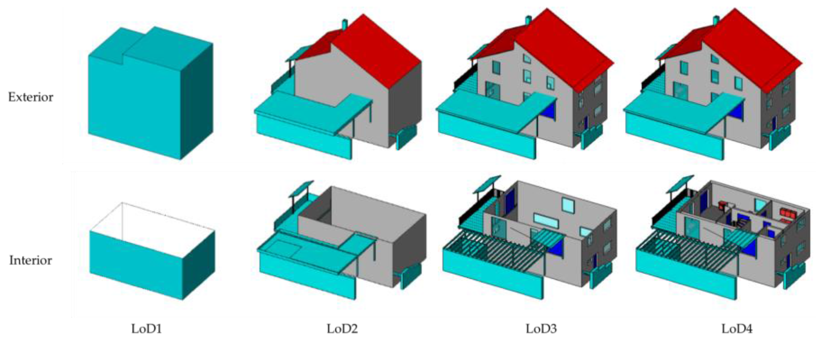
- In terms of geometry, transformation between b-rep and other 3D geometry shapes, including CSG and sweep volume, should be studied. By far, the methods for transferring b-rep to other shapes have been developed, while the transformation of other shapes to b-rep have not, and it is the most essential step to finish geometry transformation from CityGML. Apart from transformation between shape forms, level of detail harmonization is also important. Both IFC and CityGML have 5 definitions for LoD or LOD; however, they could not be matched correspondingly. For instance, the lowest LOD of IFC could not be simply matched with the lowest LoD of CityGML. Appropriate links between them should be well developed.
- (2)
- CityGML extension. The number of classes defined in CityGML is much less than that of IFC, which is the major cause for semantic mismatch between them. Therefore, in the future, the CityGML standard is better to be upgraded. Even though it supports ADEs to extend existing features, too many customized ADEs would impair information sharing and exchange in the area. A better solution is to upgrade CityGML itself, to add more classes. Additionally, this work could utilize the current ADEs and depends on the effort from OGC. This would also benefit the construction of ontology of GIS, which could be used in the semantic web that is promising for bidirectional information exchange between BIM and GIS.
- (3)
- Methods for distinguishing objects within the same CityGML class but belonging to different IFC classes. An example would be column, stair, and beam belonging to “BuildingInstallation”. While mapping from column, stair, or beam to “BuildingInstallation” is clear, the opposite way is somewhat blurred. One has to decide to which CityGML class to transfer this feature. Without additional information, this would be impossible. A possible solution may be to add an attribute to CityGML showing its corresponding class in IFC.
- (4)
- Application exploration. The majority of current studies are targeted at buildings, while bridges, tunnels, and so on are also important parts of a city, and they also deserve to be explored.
5. Conclusions
- (1)
- GIS and BIM cannot replace each other for quite a long time, and they will continue to operate as independent but complementary systems. At present, the priority is to achieve full and effective data interoperability between them.
- (2)
- IFC and CityGML are representative data formats for BIM and GIS, respectively. Even though there are other formats involved, such as (multipatch) shapefile, they are the most studied and accepted exchange formats. Apart from that, they are also complete ontologies for building and city models that could contribute to the construction of the semantic web.
- (3)
- Geometry translation between BIM and GIS could be achieved to some extent, mainly from BIM to GIS. The output could be used for visualization and some simple analyses, such as indoor navigation and determining the shortest route between suppliers and the construction site.
- (4)
- The current solutions for semantic information exchange are likely to be project-specific. A more generic approach is needed. Additionally, this may largely rely on the extension of CityGML and the standardization of ontologies of these two areas. As the completion of ontology for a domain requires a good understanding of that domain, the ultimate integration needs the efforts of individuals and organizations from both BIM and GIS.
Acknowledgments
Author Contributions
Conflicts of Interest
References
- Volk, R.; Stengel, J.; Schultmann, F. Building Information Modeling (BIM) for existing buildings—Literature review and future needs. Autom. Constr. 2014, 38, 109–127. [Google Scholar] [CrossRef]
- Azhar, S. Building information modeling (BIM): Trends, benefits, risks, and challenges for the AEC industry. Leadersh. Manag. Eng. 2011, 11, 241–252. [Google Scholar] [CrossRef]
- Longley, P. Geographic Information Systems and Science; John Wiley & Sons: Hoboken, NJ, USA, 2005. [Google Scholar]
- Chang, K.T. Geographic Information System; Wiley Online Library: Hoboken, NJ, USA, 2006. [Google Scholar]
- Coppock, J.T.; Rhind, D.W. The history of GIS. Geogr. Inf. Syst. Princ. Appl. 1991, 1, 21–43. [Google Scholar]
- Gunes, A.E.; Kovel, J.P. Using GIS in emergency management operations. J. Urban Plan. Dev. 2000, 126, 136–149. [Google Scholar] [CrossRef]
- Cutter, S.L. GI science, disasters, and emergency management. Trans. GIS 2003, 7, 439–446. [Google Scholar] [CrossRef]
- Barredo, J.I. Major flood disasters in Europe: 1950–2005. Nat. Hazards 2007, 42, 125–148. [Google Scholar] [CrossRef]
- MarketsandMarkets. Geographic Information System (GIS) Market; MarketsandMarkets: Seattle, WA, USA, 2017. [Google Scholar]
- MarketsandMarkets. Global Building Information Modeling (BIM) Market: (2017–2021 Edition); MarketsandMarkets: Northbrook, IL, USA, 2017. [Google Scholar]
- Travaglini, A.; Radujković, M.; Mancini, M. Building information Modelling (BIM) and project management: A Stakeholders perspective. Organ. Technol. Manag. Constr. 2014, 6, 1001–1008. [Google Scholar] [CrossRef]
- Cheng, M.-Y.; Chen, J.-C. Integrating barcode and GIS for monitoring construction progress. Autom. Constr. 2002, 11, 23–33. [Google Scholar] [CrossRef]
- Cheng, M.; O’Connor, J. ArcSite: Enhanced GIS for construction site layout. J. Constr. Eng. Manag. 1996, 122, 329–336. [Google Scholar] [CrossRef]
- Li, H.; Chen, Z.; Yong, L.; Kong, S.C. Application of integrated GPS and GIS technology for reducing construction waste and improving construction efficiency. Autom. Constr. 2005, 14, 323–331. [Google Scholar] [CrossRef]
- Irizarry, J.; Karan, E.P. Optimizing location of tower cranes on construction sites through GIS and BIM integration. J. Inf. Technol. Constr. (ITcon) 2012, 17, 351–366. [Google Scholar]
- Marzouk, M.; Abubakr, A. Decision support for tower crane selection with building information models and genetic algorithms. Autom. Constr. 2016, 61, 1–15. [Google Scholar] [CrossRef]
- Bansal, V. Application of geographic information systems in construction safety planning. Int. J. Proj. Manag. 2011, 29, 66–77. [Google Scholar] [CrossRef]
- Zhang, S.; Teizer, J.; Lee, J.-K.; Eastman, C.M.; Venugopal, M. Building information modeling (BIM) and safety: Automatic safety checking of construction models and schedules. Autom. Constr. 2013, 29, 183–195. [Google Scholar] [CrossRef]
- Wang, J.; Sun, W.; Shou, W.; Wang, X.; Wu, C.; Chong, H.-Y.; Liu, Y.; Sun, C. Integrating BIM and LiDAR for real-time construction quality control. J. Intell. Robot. Syst. 2015, 79, 417–432. [Google Scholar] [CrossRef]
- Eastman, C.M.; Eastman, C.; Teicholz, P.; Sacks, R. BIM Handbook: A Guide to Building Information Modeling for Owners, Managers, Designers, Engineers and Contractors; John Wiley & Sons: Hoboken, NJ, USA, 2011. [Google Scholar]
- National BIM Standard-United States. About the National BIM Standard-United States®. Available online: https://www.nationalbimstandard.org/about (accessed on 1 February 2018).
- Tomlinson, R. A geographic information system for regional planning. J. Geogr. 1968, 78, 45–48. [Google Scholar] [CrossRef]
- Amin, M.; Noori, A. Mechanism for farm mechanization and careful planning using geographic information system (GIS). J. Bus. Technovation 2016, 4, 23–28. [Google Scholar]
- Zhang, J.; Hu, Z. BIM-and 4D-based integrated solution of analysis and management for conflicts and structural safety problems during construction: 1. Principles and methodologies. Autom. Constr. 2011, 20, 155–166. [Google Scholar] [CrossRef]
- Azhar, S.; Brown, J.; Farooqui, R. BIM-based sustainability analysis: An evaluation of building performance analysis software. In Proceedings of the 45th ASC Annual Conference, Gainesville, FL, USA, 1–4 April 2009. [Google Scholar]
- Lee, S.-K.; Kim, K.-R.; Yu, J.-H. BIM and ontology-based approach for building cost estimation. Autom. Constr. 2014, 41, 96–105. [Google Scholar] [CrossRef]
- Motawa, I.; Almarshad, A. A knowledge-based BIM system for building maintenance. Autom. Constr. 2013, 29, 173–182. [Google Scholar] [CrossRef]
- Hu, Z.; Zhang, J. BIM-and 4D-based integrated solution of analysis and management for conflicts and structural safety problems during construction: 2. Development and site trials. Autom. Constr. 2011, 20, 167–180. [Google Scholar] [CrossRef]
- Kang, T.W.; Hong, C.H. A study on software architecture for effective BIM/GIS-based facility management data integration. Autom. Constr. 2015, 54, 25–38. [Google Scholar] [CrossRef]
- Teo, T.-A.; Cho, K.-H. BIM-oriented indoor network model for indoor and outdoor combined route planning. Adv. Eng. Inform. 2016, 30, 268–282. [Google Scholar] [CrossRef]
- Deng, Y.; Cheng, J.C.; Anumba, C. A framework for 3D traffic noise mapping using data from BIM and GIS integration. Struct. Infrastruct. Eng. 2016, 12, 1267–1280. [Google Scholar] [CrossRef]
- Amirebrahimi, S.; Rajabifard, A.; Mendis, P.; Ngo, T. A framework for a microscale flood damage assessment and visualization for a building using BIM–GIS integration. Int. J. Digit. Earth 2016, 9, 363–386. [Google Scholar] [CrossRef]
- Amirebrahimi, S.; Rajabifard, A.; Mendis, P.; Ngo, T. A BIM-GIS integration method in support of the assessment and 3D visualisation of flood damage to a building. J. Spat. Sci. 2016, 61, 317–350. [Google Scholar] [CrossRef]
- Di Giulio, R.; Turillazzi, B.; Marzi, L.; Pitzianti, S. Integrated BIM-GIS based design for high energy efficiency hospital buildings. TECHNE-J. Technol. Archit. Environ. 2017, 243–255. [Google Scholar] [CrossRef]
- Blengini, G.A.; Garbarino, E. Resources and waste management in Turin (Italy): The role of recycled aggregates in the sustainable supply mix. J. Clean. Prod. 2010, 18, 1021–1030. [Google Scholar] [CrossRef]
- Wang, T.-K.; Zhang, Q.; Chong, H.-Y.; Wang, X. Integrated supplier selection framework in a resilient construction supply chain: An approach via analytic hierarchy process (AHP) and grey relational analysis (GRA). Sustainability 2017, 9, 289. [Google Scholar] [CrossRef]
- Irizarry, J.; Karan, E.P.; Jalaei, F. Integrating BIM and GIS to improve the visual monitoring of construction supply chain management. Autom. Constr. 2013, 31, 241–254. [Google Scholar] [CrossRef]
- Aziz, Z.; Anumba, C.; Ruikar, D.; Carrillo, P.; Bouchlaghem, D. Intelligent wireless web services for construction—A review of the enabling technologies. Autom. Constr. 2006, 15, 113–123. [Google Scholar] [CrossRef]
- Atazadeh, B.; Kalantari, M.; Rajabifard, A.; Ho, S.; Ngo, T. Building Information Modelling for High-rise Land Administration. Trans. GIS 2017, 21, 91–113. [Google Scholar] [CrossRef]
- ONUMA. Building Information Model Extended Markup Language (BIMXML). Available online: http://bimxml.org/ (accessed on 1 February 2018).
- TechniaTranscat. COINS for BIM. Available online: http://www.infostrait.nl/en/civil-infrastructure-construction/coins-bim/ (accessed on 30 January 2018).
- Mignard, C.; Nicolle, C. Merging BIM and GIS using ontologies application to urban facility management in ACTIVe3D. Comput. Ind. 2014, 65, 1276–1290. [Google Scholar] [CrossRef]
- Donkers, S.; Ledoux, H.; Zhao, J.; Stoter, J. Automatic conversion of IFC datasets to geometrically and semantically correct CityGML LOD3 buildings. Trans. GIS 2016, 20, 547–569. [Google Scholar] [CrossRef]
- Forum, B. Level of Development Specification. Available online: http://bimforum.org/lod/ (accessed on 20 February 2018).
- BuildingSMART. IFC Overview Summary. Available online: http://www.buildingsmart-tech.org/specifications/ifc-overview (accessed on 29 January 2018).
- Deng, Y.; Cheng, J.C.; Anumba, C. Mapping between BIM and 3D GIS in different levels of detail using schema mediation and instance comparison. Autom. Constr. 2016, 67, 1–21. [Google Scholar] [CrossRef]
- Gröger, G.; Kolbe, T.; Nagel, C.; Häfele, K. OGC City Geography Markup Language (CityGML) Encoding Standard, version 2.0; OGC Doc; Open Geospatial Consortium: Wayland, MA, USA, 2012. [Google Scholar]
- De Laat, R.; Van Berlo, L. Integration of BIM and GIS: The development of the CityGML GeoBIM extension. In Advances in 3D Geo-Information Sciences; Springer: Berlin/Heidelberg, Germany, 2011; pp. 211–225. [Google Scholar]
- Delgado, F.; Martínez, R.; Puche, J.; Finat, J. Towards a client-oriented integration of construction processes and building GIS systems. Comput. Ind. 2015, 73, 51–68. [Google Scholar] [CrossRef]
- ESRI. The Multipatch Geometry Type An Esri White Paper; ESRI: Redlands, CA, USA, 2008. [Google Scholar]
- Kang, T.W.; Hong, C.H. IFC-CityGML LOD mapping automation using multiprocessing-based screen-buffer scanning including mapping rule. KSCE J. Civ. Eng. 2017, 1–11. [Google Scholar] [CrossRef]
- Kang, T.; Hong, C. IFC-CityGML LOD Mapping Automation based on Multi-Processing. In Proceedings of the 32nd International Symposium on Automation and Robotics in Construction (ISARC), Oulu, Finland, 15–18 June 2015. [Google Scholar]
- Jusuf, S.K.; Mousseau, B.; Godfroid, G.; Hui, V.S.J. Integrated modeling of CityGML and IFC for city/neighborhood development for urban microclimates analysis. Energy Procedia 2017, 122, 145–150. [Google Scholar] [CrossRef]
- Xu, M.; Hijazi, I.; Mebarki, A.; Meouche, R.E.; Abune’meh, M. Indoor guided evacuation: TIN for graph generation and crowd evacuation. Geomat. Nat. Hazards Risk 2016, 7, 47–56. [Google Scholar] [CrossRef]
- Tashakkori, H.; Rajabifard, A.; Kalantari, M. A new 3D indoor/outdoor spatial model for indoor emergency response facilitation. Build. Environ. 2015, 89, 170–182. [Google Scholar] [CrossRef]
- Hor, A.-H.; Jadidi, A.; Sohn, G. BIM-GIS integrated geospatial information model using semantic WEB and RDF graphs. ISPRS Ann. Photogramm. Remote Sens. Spat. Inf. Sci. 2016, 3, 73–79. [Google Scholar] [CrossRef]
- Wu, I.C.; Hsieh, S.H. Transformation from IFC data model to GML data model: Methodology and tool development. J. Chin. Inst. Eng. 2007, 30, 1085–1090. [Google Scholar] [CrossRef]
- Donkers, S. Automatic Generation fo CityGML LoD3 Building Models from IFC Models. Master’s Thesis, Delft University of Technology, Delft, The Netherlands, 2013. [Google Scholar]
- Borrmann, A.; Kolbe, T.H.; Donaubauer, A.; Steuer, H.; Jubierre, J.R.; Flurl, M. Multi-scale geometric-semantic modeling of shield tunnels for GIS and BIM applications. Comput.-Aided Civ. Infrastruct. Eng. 2015, 30, 263–281. [Google Scholar] [CrossRef]
- El-Mekawy, M.; Östman, A.; Shahzad, K. Towards interoperating CityGML and IFC building models: A unified model based approach. In Advances in 3D Geo-Information Sciences; Springer: Berlin/Heidelberg, Germany, 2011; pp. 73–93. [Google Scholar]
- Isikdag, U.; Zlatanova, S.; Underwood, J. A BIM-oriented model for supporting indoor navigation requirements. Comput. Environ. Urban Syst. 2013, 41, 112–123. [Google Scholar] [CrossRef]
- Amirebrahimi, S.; Rajabifard, A.; Mendis, P.; Ngo, T. A data model for integrating GIS and BIM for assessment and 3D visualisation of flood damage to building. Locate 2015, 15, 10–12. [Google Scholar]
- Antoniou, G.; Van Harmelen, F. A Semantic Web Primer; MIT Press: London, UK, 2008. [Google Scholar]
- Wang, W.; De, S.; Cassar, G.; Moessner, K. Knowledge representation in the internet of things: Semantic modelling and its applications. Automatika 2013, 54, 388–400. [Google Scholar] [CrossRef]
- Karan, E.P.; Irizarry, J.; Haymaker, J. BIM and GIS integration and interoperability based on semantic web technology. J. Comput. Civ. Eng. 2015, 30, 04015043. [Google Scholar] [CrossRef]
- Karan, E.P.; Irizarry, J. Extending BIM interoperability to preconstruction operations using geospatial analyses and semantic web services. Autom. Constr. 2015, 53, 1–12. [Google Scholar] [CrossRef]
- Costa, G.; Sicilia, Á.; Lilis, G.; Rovas, D.; Izkara, J. A comprehensive ontologies-based framework to support retrofitting design of energy-efficient districts. In Proceedings of the European Conference on Product and Process Modelling (ECPPM), Limassol, Cyprus, 7–9 September 2016. [Google Scholar]
- Yamamura, S.; Fan, L.; Suzuki, Y. Assessment of Urban Energy Performance through Integration of BIM and GIS for Smart City Planning. Procedia Eng. 2017, 180, 1462–1472. [Google Scholar] [CrossRef]
- Zhu, J.; Tan, Y.; Wang, J.; Wang, X. An economical approach to geo-referencing 3D model for integration of BIM and GIS. In Proceedings of the International Conference on Innovative Production and Construction (IPC 2017), Perth, Australia, 30 November–1 December 2017. [Google Scholar]


| Geometry Level | Semantics Level | |
|---|---|---|
| Level of difficulty to achieve | Median | High |
| Purpose | Visualizaiton | Visualization/Analysis |
| Direction of information flow | One-way from BIM to GIS | Bidirectional |
| Richness of information | Low | High |
| Semantic loss | Yes | No |
| Issues | IFC to CityGML | CityGML to IFC | |
|---|---|---|---|
| Geometry | B-rep/b-rep transformation | √ | × |
| B-rep/CSG transformation | √ | × | |
| B-rep/sweep volume transformation | √ | × | |
| Semantics | Classes mapping | √ | × |
| Built structures | Building | √ | √ |
| Bridge | × | × | |
| Tunnel | × | × |
© 2018 by the authors. Licensee MDPI, Basel, Switzerland. This article is an open access article distributed under the terms and conditions of the Creative Commons Attribution (CC BY) license (http://creativecommons.org/licenses/by/4.0/).
Share and Cite
Zhu, J.; Wright, G.; Wang, J.; Wang, X. A Critical Review of the Integration of Geographic Information System and Building Information Modelling at the Data Level. ISPRS Int. J. Geo-Inf. 2018, 7, 66. https://doi.org/10.3390/ijgi7020066
Zhu J, Wright G, Wang J, Wang X. A Critical Review of the Integration of Geographic Information System and Building Information Modelling at the Data Level. ISPRS International Journal of Geo-Information. 2018; 7(2):66. https://doi.org/10.3390/ijgi7020066
Chicago/Turabian StyleZhu, Junxiang, Graeme Wright, Jun Wang, and Xiangyu Wang. 2018. "A Critical Review of the Integration of Geographic Information System and Building Information Modelling at the Data Level" ISPRS International Journal of Geo-Information 7, no. 2: 66. https://doi.org/10.3390/ijgi7020066
APA StyleZhu, J., Wright, G., Wang, J., & Wang, X. (2018). A Critical Review of the Integration of Geographic Information System and Building Information Modelling at the Data Level. ISPRS International Journal of Geo-Information, 7(2), 66. https://doi.org/10.3390/ijgi7020066


