WebGIS for Geography Education: Towards a GeoCapabilities Approach
Abstract
:1. Introduction
2. GIS in Geography Education
2.1. WebGIS
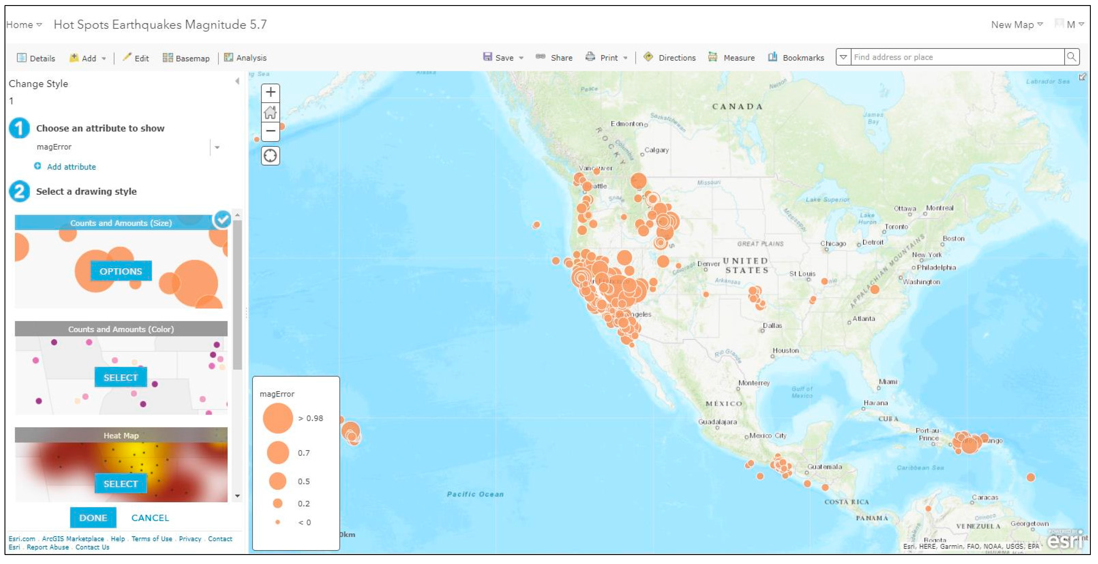
2.1.1. Smart Mapping
2.1.2. Open Source Data
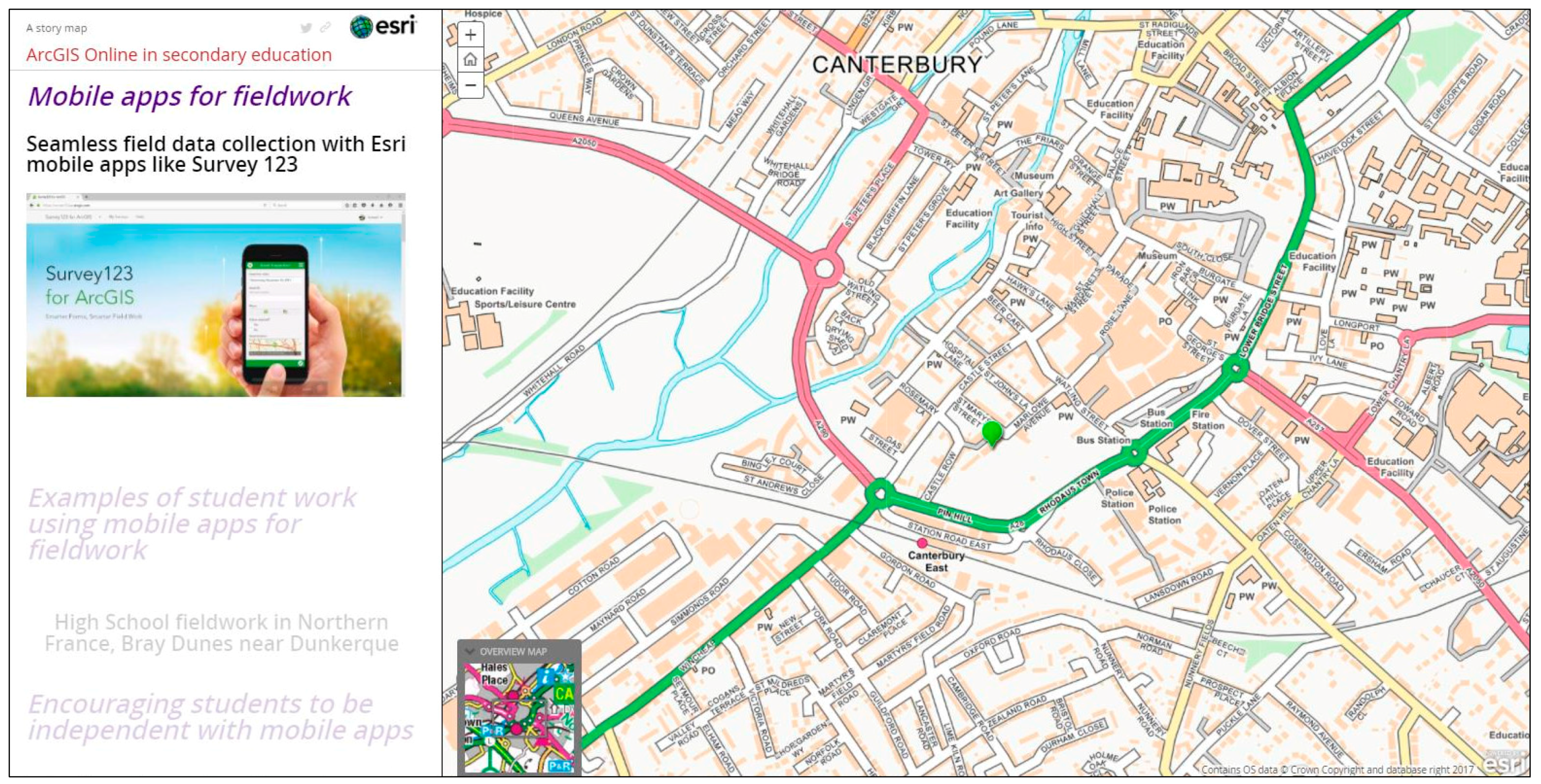
2.1.3. Mobile Applications
2.2. GeoCapabilities
2.2.1. Powerful Disciplinary Knowledge (PDK)
2.2.2. Curriculum Futures
- F1 Subject ‘delivery’: the curriculum as ‘given’. Arranged within traditional subjects with a stable body of core knowledge. This is under-socialised knowledge.
- F2 Skills, competences and ‘learning to learn’. An approach that considers traditional subject divisions as ‘arbitrary’. Integrated themes and issues are preferred. This is experiential and over-socialised knowledge.
- F3 Capabilities. Subjects are not ‘given’ or ‘arbitrary’. Knowledge development is led by epistemic rules of recognized subject specialist communities to provide ways to understand the world and take pupils beyond their everyday experience [36].
2.2.3. Curriculum Making
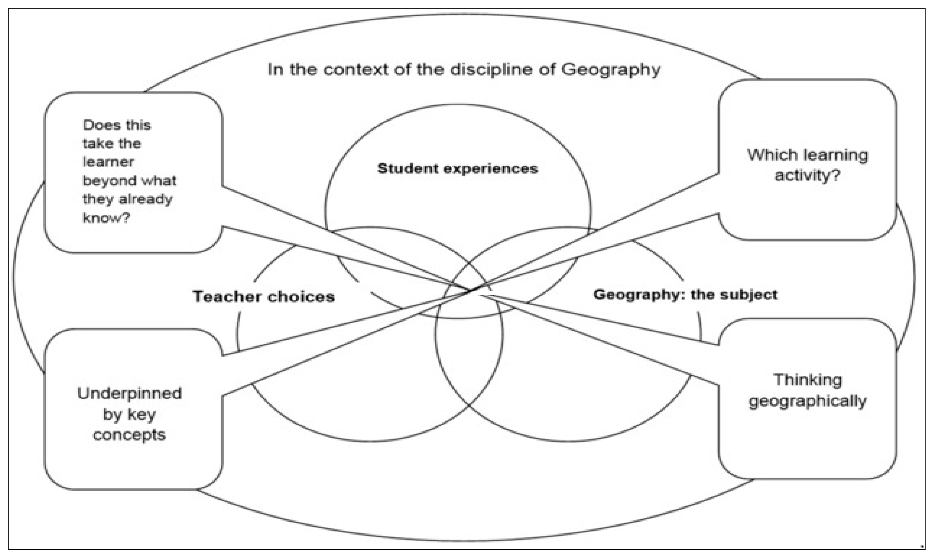
- Underpinning the curriculum with geography’s key concepts;
- Taking a the learner beyond what they already know;
- Choosing learning activities which reflect curricular aims that are adapted to student needs and experiences;
- Engaging young people in thinking geographically.
2.2.4. Curriculum Artefacts
3. A WebGIS Geography Artefact: Discussion and Analysis
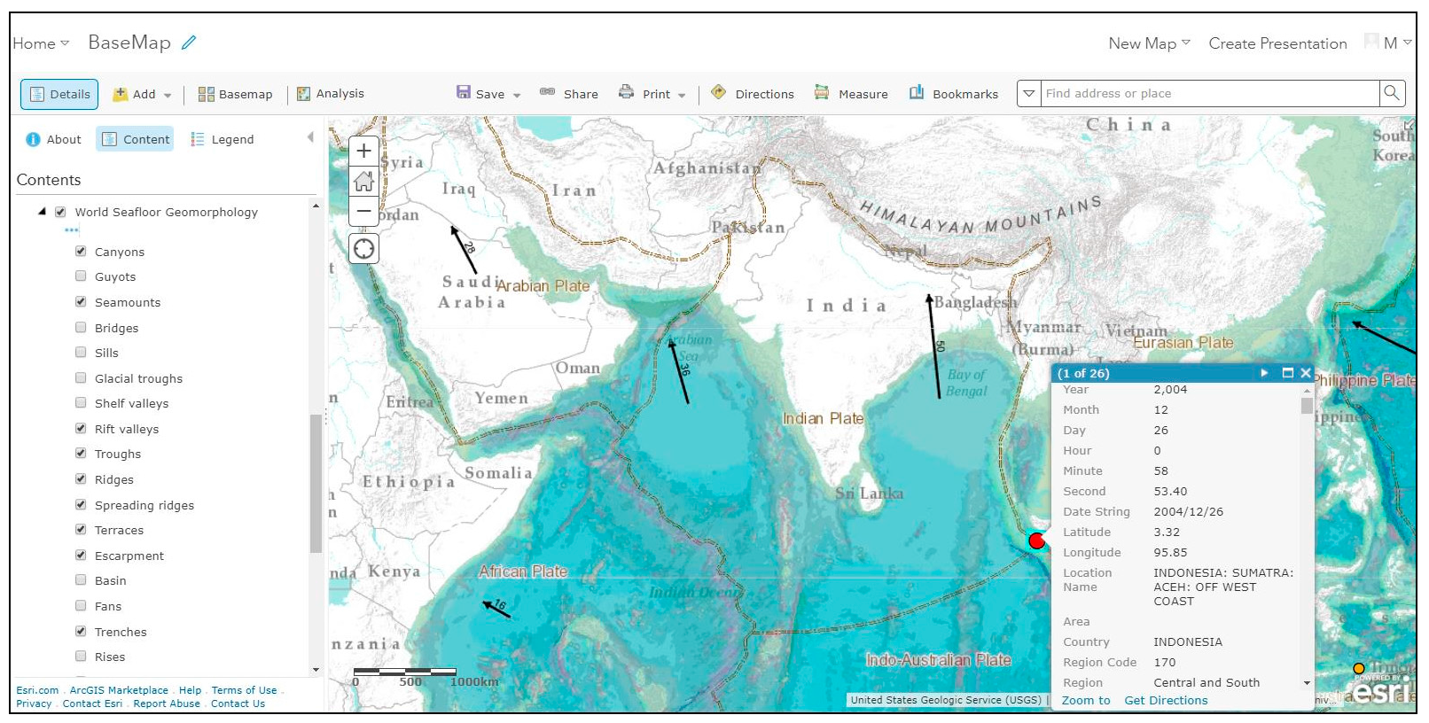
3.1. Using Interconnection to Explain the Causes of the 2004 Indian Ocean Earthquake (Type 2 Powerful Knowledge)
- The relative location of the earthquake to plate boundaries
- The magnitude and intensity of the earthquake in relation to the build-up of tectonic pressure as the Indian plate subducts under the Burma plate
- The release of pressure as the strike-slip fault running along the seabed ruptured north south from the line of subduction north to the earthquake epicentre in the south
- The subsequent shifting of the ocean east-west as the fault failed
- The generation and direction of travel of tsunamis
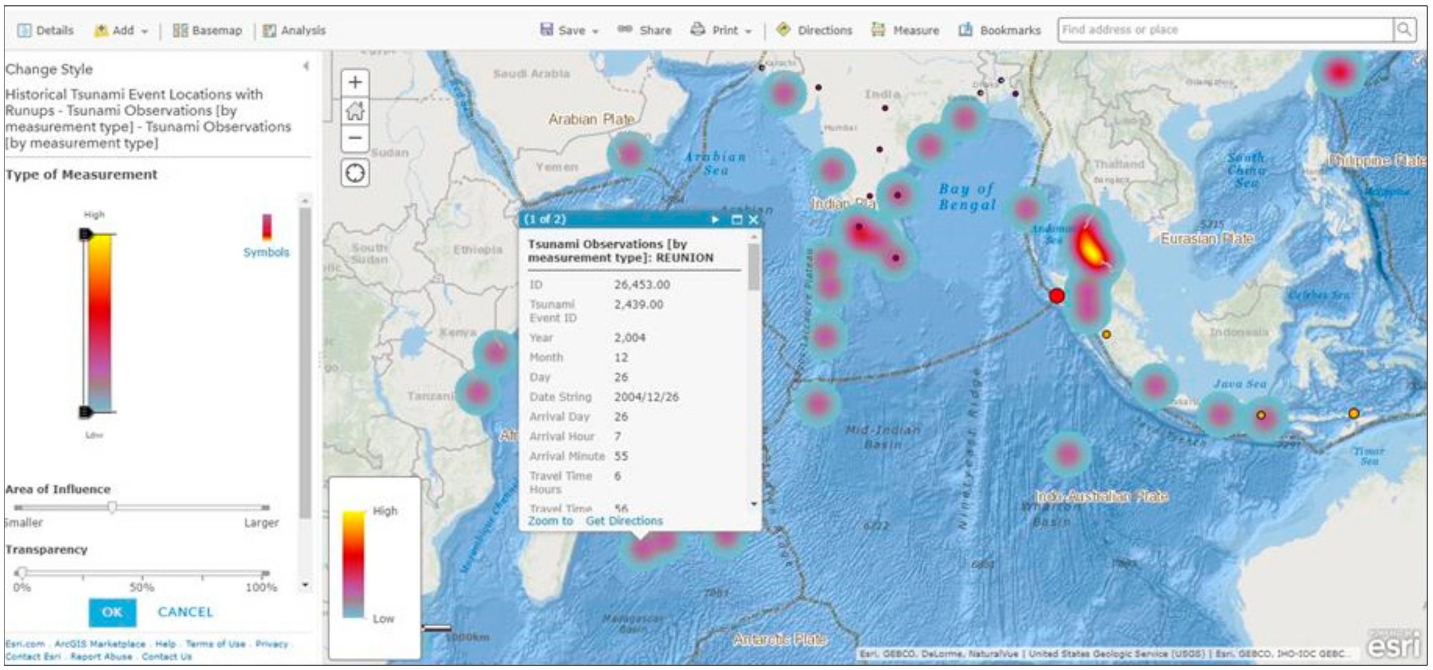
3.2. Using Space and Place to Analyse Regional and Local Variations in Tsunami Impacts (Type 2 Powerful Knowledge)
- The east-west spread of the tsunamis radiating from the north-south tectonic fault
- Variations in arrival times (e.g., 15 min Sumatra/7 h Somalia)
- The role of distance (e.g., nearby Bangladesh experienced fewer casualties/distant Somalia more casualties)
- Unexpected high impacts in distant places (e.g., Kerala, Indiadespite an intervening landmass, Sri Lanka west coast via headland wave defraction)
- Tsunami lag time in Thailand despite proximity, as waves slowed down in the shallowerAndaman sea
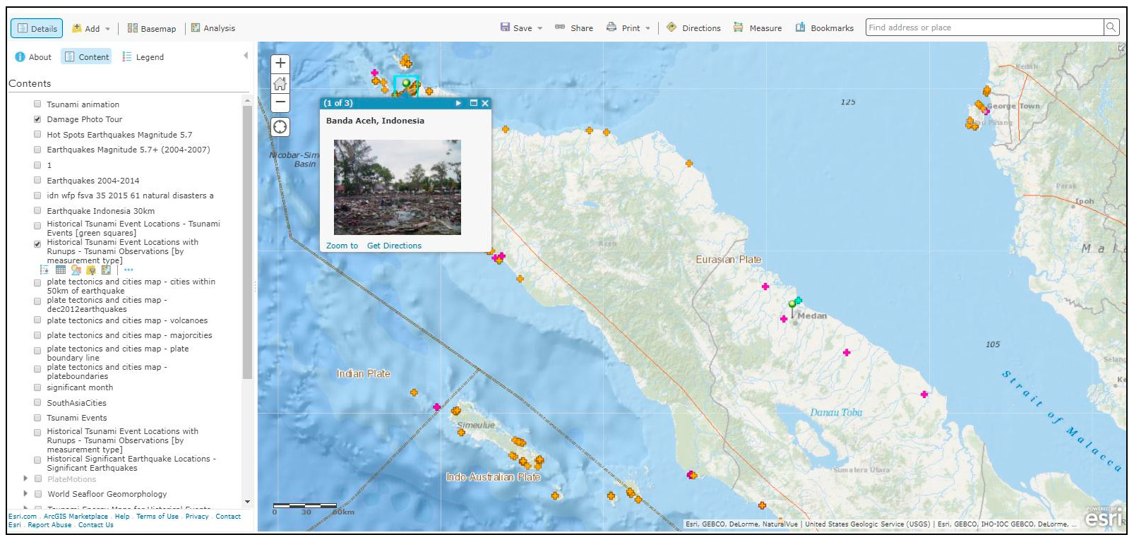
3.3. Using Place to Analyse Variations in Tsunami Impacts at a Local Scale (Type 2 Powerful Knowledge)
- the contrasting inundation of tsunami on the west (less affected) side of the Banda Aceh coast as opposed to the east sea side (more affected)
- Coastal villages on the low-lying islands of Weh, Breuh and Nasi just north of the mainland that were completely destroyed
- Lhoknga, the first major town to be hit by tsunami which received waves as high as 30 metres and was totally destroyed
- Meulobah, where the inland inundation reached over 5 kilometres [44]
3.4. Using Place, Space and Interconnection to Make Generalisations (Types 2, 3 and 5 Powerful Knowledge)
4. Conclusions
Author Contributions
Conflicts of Interest
References
- Lambert, D. Curriculum Thinking, ‘Capabilities’ and the Place of Geographical Knowledge in Schools. J. Jpn. Educ. Res. Assoc. Soc. Stud. 2014, 81, 1–11. [Google Scholar]
- ESRI Smart Mapping. Available online: http://www.esri.com/software/arcgis/smart-mapping (accessed on 31 August 2017).
- ESRI Story Maps. Available online: https://storymaps.arcgis.com/en/ (accessed on 31 August 2017).
- Young, M.; Lambert, D.; Roberts, C.R.; Roberts, M.D. Knowledge and the Future School: Curriculum and Social Justice; Bloomsbury: London, UK, 2014. [Google Scholar]
- Biddulph, M.; Lambert, D.; Balderstone, D. Learning to Teach Geography in the Secondary School: A Companion to School Experience; Routledge: Abingdon, UK, 2015. [Google Scholar]
- Lambert, D.; Morgan, J. Teaching Geography 11–18: A Conceptual Approach; Open University Press: London, UK, 2010. [Google Scholar]
- Curriculum Artefacts. Available online: http://www.geocapabilities.org/training-materials/module-2-curriculum-making-by-teachers/into-practice/ (accessed on 31 August 2017).
- Maude’s Typology of Powerful Geography. Available online: http://www.geocapabilities.org/wp-content/uploads/2016/02/A-typology-of-geography%E2%80%99s-powerful-knowledge.pdf (accessed on 31 August 2017).
- National Research Council and Geographical Sciences Committee. Learning to Think Spatially; National Academies Press: Washington, DC, USA, 2008. [Google Scholar]
- Fargher, M. Using Geographic Information (GI). In Debates in Geography Education, 2nd ed.; Jones, M., Lambert, D., Eds.; Routledge: Abingdon, UK, 2017; pp. 197–210. [Google Scholar]
- Favier, T.T.; Van der Schee, J.A. Exploring the characteristics of an optimal design for inquiry-based geography education with Geographic Information Systems. Comput. Educ. 2012, 58, 666–677. [Google Scholar] [CrossRef]
- Lei, P.L.; Kao, G.Y.M.; Lin, S.S.; Sun, C.T. Impacts of geographical knowledge, spatial ability and environmental cognition on image searches supported by GIS software. Comput. Hum. Behav. 2009, 25, 1270–1279. [Google Scholar] [CrossRef]
- Fargher, M.; Rayner, D. United Kingdom: Realizing the potential for GIS in the school geography curriculum. In International Perspectives on Teaching and Learning with GIS in Secondary Schools; Milson, A.J., Demirci, A., Kerski, J.J., Eds.; Springer: Dordrecht, The Netherlands, 2012; pp. 299–304. [Google Scholar]
- ESRI Geographic Inquiry: Thinking Geographically. Available online: http://www.esri.com/Industries/k-12/education/~/media/Files/Pdfs/industries/k-12/pdfs/geoginquiry.pdf (accessed on 31 August 2017).
- Roberts, M. Geography through Enquiry; Geographical Association: Sheffield, UK, 2013. [Google Scholar]
- Kerski, J.J. The implementation and effectiveness of geographic information systems, technology and methods in secondary education. J. Geogr. 2003, 102, 128–137. [Google Scholar] [CrossRef]
- Fargher, M. GIS and other geospatial technologies. In Handbook of Secondary Geography; Jones, M., Ed.; Geographical Association: Sheffield, UK, 2017; pp. 244–259. [Google Scholar]
- Xerox Park Map Viewer. Available online: https://web.archive.org/web/20060916133035/http://www2.parc.com/istl/projects/www94/mapviewer.html (accessed on 31 August 2017).
- Worldwide Earthquake Locator. Available online: https://www.geos.ed.ac.uk/~quakes/v6_beta/map.html (accessed on 31 August 2017).
- GLOBE. Available online: https://www.globe.gov/about/history (accessed on 31 August 2017).
- KanCRN. Available online: http://www.pathfinderscience.net/about (accessed on 31 August 2017).
- Journey North. Available online: https://www.learner.org/jnorth/maps (accessed on 31 August 2017).
- Baker, T.R. WebGIS in Education. In Geospatial Technologies and Geography Education in a Changing World; Muñiz Solari, O., Demirci, A., van der Schee, J.A., Eds.; Springer: Dordrecht, The Netherlands, 2015; pp. 105–115. [Google Scholar]
- ESRI ArcGIS Online. Available online: http://www.esri.com/software/arcgis/arcgisonline (accessed on 31 August 2017).
- QGIS. Available online: https://www.qgis.org/en/site/ (accessed on 31 August 2017).
- ESRI UK Getting Started with ArcGIS Online. Available online: https://schools.esriuk.com/wp-content/uploads/Getting_started_with_ArcGIS_Online.pdf (accessed on 31 August 2017).
- EDINA Digimap OpenStream. Available online: https://openstream.edina.ac.uk/ (accessed on 31 August 2017).
- QGIS. Teaching Materials. Available online: https://mapstream.edina.ac.uk/resources/Fracking/Frackinginstructions.pdf (accessed on 31 August 2017).
- ESRI Survey 123 for ArcGIS. Available online: https://survey123.arcgis.com/ (accessed on 31 August 2017).
- ArcGIS Online in Secondary Education. Michael Gould ESRI, Thierry Torres, Antwerp International School Story Map. Available online: http://dgsb.maps.arcgis.com/apps/MapJournal/index.html?appid=820ed382cdd6442996728fa3bfae2293 (accessed on 31 August 2017).
- Nussbaum, M.; Sen, A. The Quality of Life; Oxford University Press: Oxford, UK, 1993. [Google Scholar]
- Lambert, D.; Solem, M.; Tani, S. Achieving human potential through geography education: A capabilities approach to curriculum making in schools. Ann. Assoc. Am. Geogr. 2015, 105, 723–735. [Google Scholar] [CrossRef]
- Young, M. Bringing Knowledge Back in London; Routledge: London, UK, 2008. [Google Scholar]
- Solem, M.; Lambert, D.; Tani, S. Geocapabilities: Towards an international framework for researching the purposes and values of geography education. Rev. Int. Geogr. Educ. Online 2013, 3, 204–219. [Google Scholar]
- Maude, A. What might Powerful Knowledge look like? Geography 2016, 101, 70–76. [Google Scholar]
- Young, M.; Muller, J. Three Educational Scenarios for the Future: Lessons from the Sociology of Knowledge. Eur. J. Educ. 2010, 45, 11–27. [Google Scholar] [CrossRef]
- Mitchell, D.; Lambert, D. Subject knowledge and teacher preparation in English secondary schools: The case of geography. Teach. Dev. 2015, 19, 365–380. [Google Scholar] [CrossRef]
- Lambert, B.; Biddulph, M. The dialogic space offered by curriculum-making in the process of learning to teach, and the creation of a progressive knowledge-led curriculum. Asia-Pac. J. Teach. Educ. 2015, 43, 210–224. [Google Scholar] [CrossRef]
- Curriculum Making. Available online: http://www.geocapabilities.org/training-materials/module-2-curriculum-making-by-teachers/theory (accessed on 31 August 2017).
- Curriculum Artefacts. Available online: http://geocapabilities.org.gridhosted.co.uk/wp-content/uploads/2016/02/Curriculum-Making-using-curriculum-artefacts.pdf (accessed on 31 August 2017).
- Maude, A. Applying the concept of powerful knowledge in school geography. In The Power of Geographical Thinking; Brooks, C., Butt, G., Fargher, M., Eds.; Springer: Cham, Switzerland, 2017; pp. 27–40. [Google Scholar]
- 2004 Indian Ocean Earthquake. Available online: http://www.newworldencyclopedia.org/entry/2004_Indian_Ocean_earthquake (accessed on 31 August 2017).
- Rediscovering Geography Committee. Rediscovering Geography: New Relevance for Science and Society; National Academy Press: Washington, DC, USA, 1997. [Google Scholar]
- Saatcioglu, M.; Ghobarah, A.; Nistor, I. Effects of the December 26, 2004 Sumatra earthquake and tsunami on physical infrastructure. ISET J. Earthq. Technol. 2005, 42, 79–94. [Google Scholar]
- Massey, D. Taking on the World. Geography 2014, 99, 36–39. [Google Scholar]


| Step | What to Do | Type of Knowledge Construction |
|---|---|---|
| Ask a geographical question | Ask questions about the world around you | Enquiry |
| Acquire geographical data | Identify data and information that you need to answer your questions | Inventory |
| Explore geographical data | Turn the data into maps, tables, graphs and look for patterns and relationships | Spatial processing and analysis |
| Analyse geographical information | Test a hypothesis, carry out map, statistical, written analysis using evidence | Spatial Analysis, Modelling, Decision Making |
| Type | Characteristic |
|---|---|
| Using ‘big ideas’ such as: • Place • Space • Environment • Interconnection These are meta-concepts that are distinguished from substantive concepts, like ‘city’ or ‘climate’. |
| Using ideas to:
|
| To do this, students need to know something about the ways knowledge has been, and continues to be developed and tested in the discipline. This is about having an answer to the question: ‘how do you know?’ This is an underdeveloped area of geographical education, but is a crucial aspect of ‘epistemic quality’ (Hudson, 2016). |
| School geography has a good record in teaching this knowledge, partly because it combines the natural and social sciences, and the humanities. It also examines significant ‘nexus’ issues such as: food, water and energy security; climate change; development. |
| This takes students beyond their own experience—the world’s diversity of environments, cultures societies and economies. In a sense, this knowledge is closest to how geography is perceived in the popular imagination. It contributes strongly to a student’s ‘general knowledge’. |
| Powerful Geography Knowledge | Pedagogy |
|---|---|
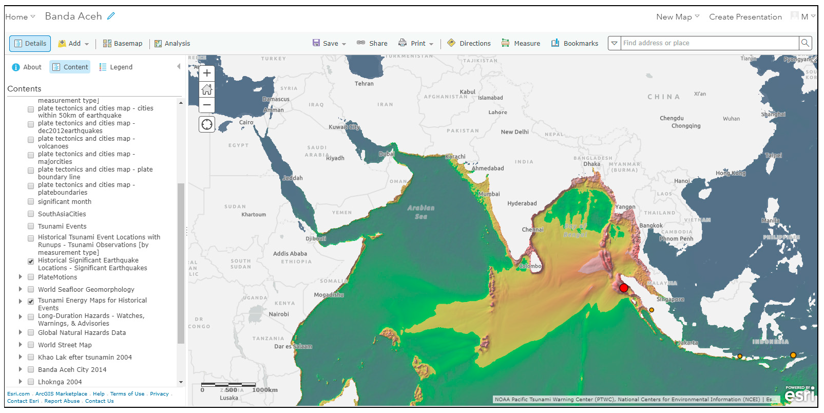
| Using geography’s concepts of place, space and interconnection to unravel the complexity of the earthquake–tsunami (Figure 5 The artefactbase map) |
| Using interconnection to explain causes and effects (Figure 6 Exploring the causes and effects of the Indian Ocean tsunami) Using place to compare landforms (Figure 7 Exploring the shape of the ocean floor) Using space and place to explore regional and local variations in tsunami impacts (Figure 8 Exploring tsunami hotspots) Using place to study tsunami impact variations at local places (Figure 9 Aceh, Indonesia) Using interconnection, place and space to synthesise knowledge and make generalisations (Figure 5, Figure 6, Figure 7, Figure 8 and Figure 9) |
| Identifying, mapping and analysing tsunami hotspots (Figure 5, Figure 6, Figure 7, Figure 8 and Figure 9) |
| Examining the earthquake/tsunami and its causes and local and regional impacts as a nexus event (Figure 5, Figure 6, Figure 7, Figure 8 and Figure 9) |
| Knowledge that takes students to places beyond their own experience by thinking with concepts of interconnection, place and space (Figure 5, Figure 6, Figure 7, Figure 8 and Figure 9) |
© 2018 by the author. Licensee MDPI, Basel, Switzerland. This article is an open access article distributed under the terms and conditions of the Creative Commons Attribution (CC BY) license (http://creativecommons.org/licenses/by/4.0/).
Share and Cite
Fargher, M. WebGIS for Geography Education: Towards a GeoCapabilities Approach. ISPRS Int. J. Geo-Inf. 2018, 7, 111. https://doi.org/10.3390/ijgi7030111
Fargher M. WebGIS for Geography Education: Towards a GeoCapabilities Approach. ISPRS International Journal of Geo-Information. 2018; 7(3):111. https://doi.org/10.3390/ijgi7030111
Chicago/Turabian StyleFargher, Mary. 2018. "WebGIS for Geography Education: Towards a GeoCapabilities Approach" ISPRS International Journal of Geo-Information 7, no. 3: 111. https://doi.org/10.3390/ijgi7030111
APA StyleFargher, M. (2018). WebGIS for Geography Education: Towards a GeoCapabilities Approach. ISPRS International Journal of Geo-Information, 7(3), 111. https://doi.org/10.3390/ijgi7030111


