Measuring the Spatial Relationship Information of Multi-Layered Vector Data


Abstract
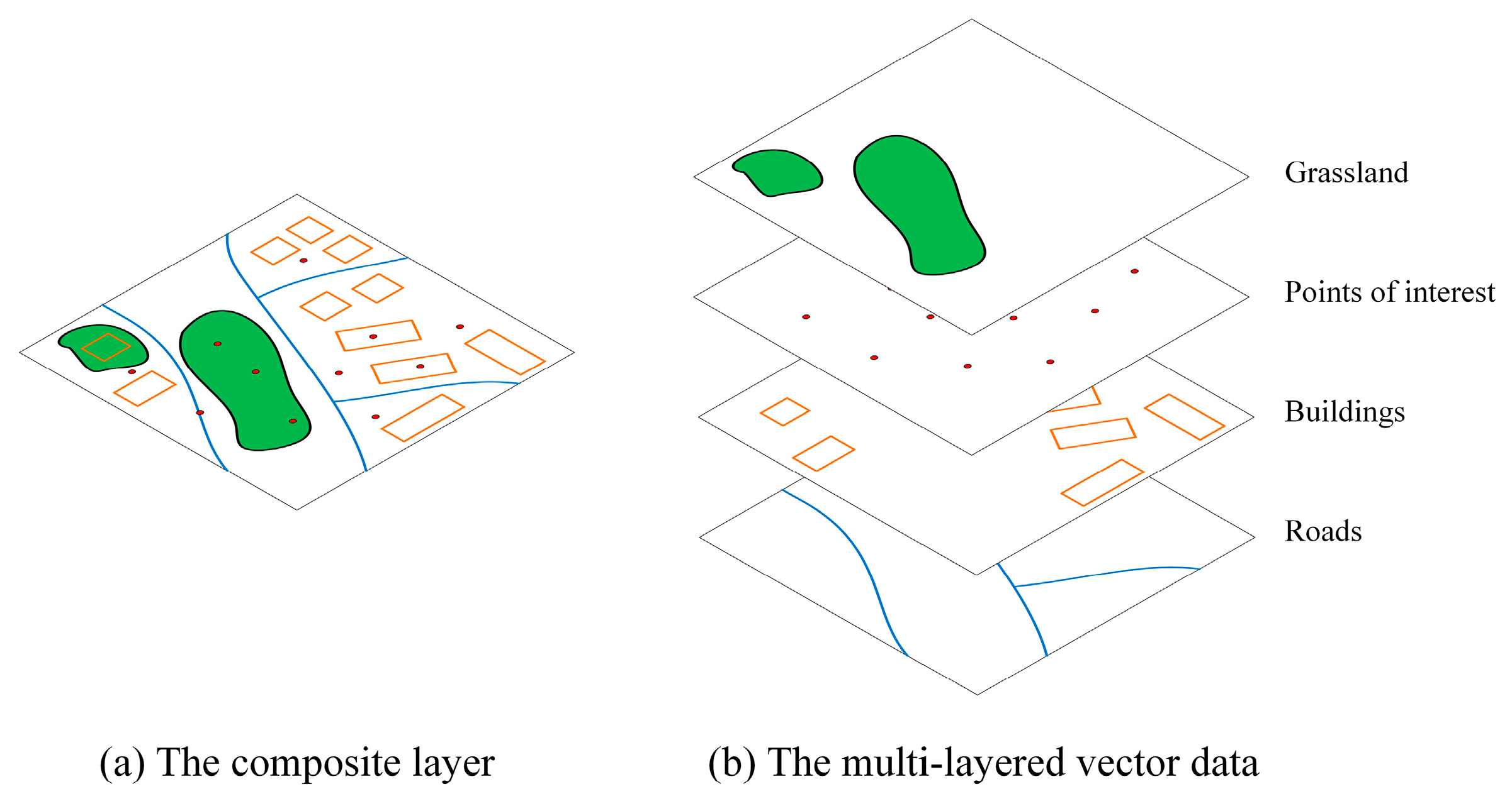
:1. Introduction
2. Models
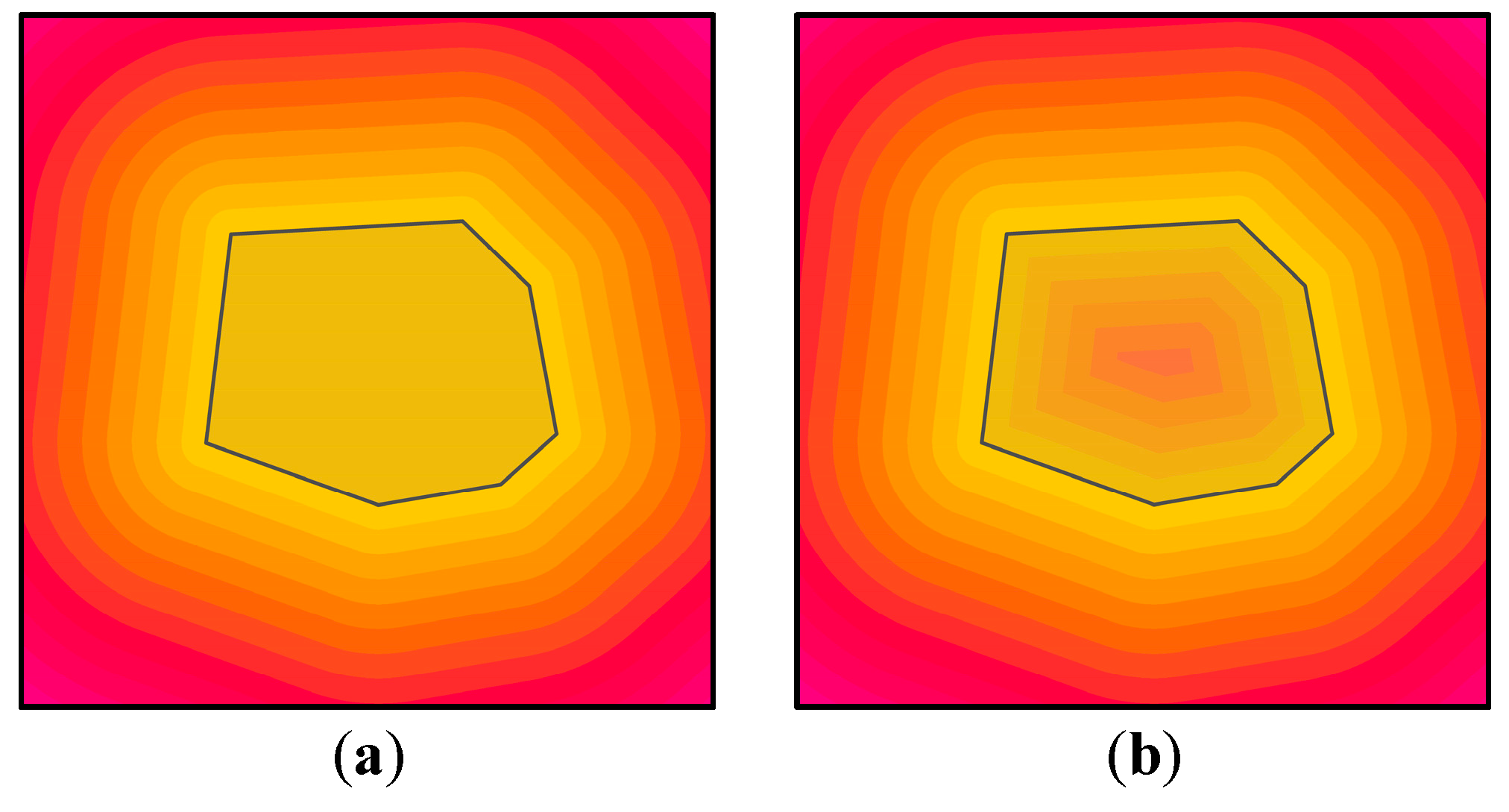
2.1. Energy Field Based on Euclidean Distance
2.2. The Information Content of an Energy Set
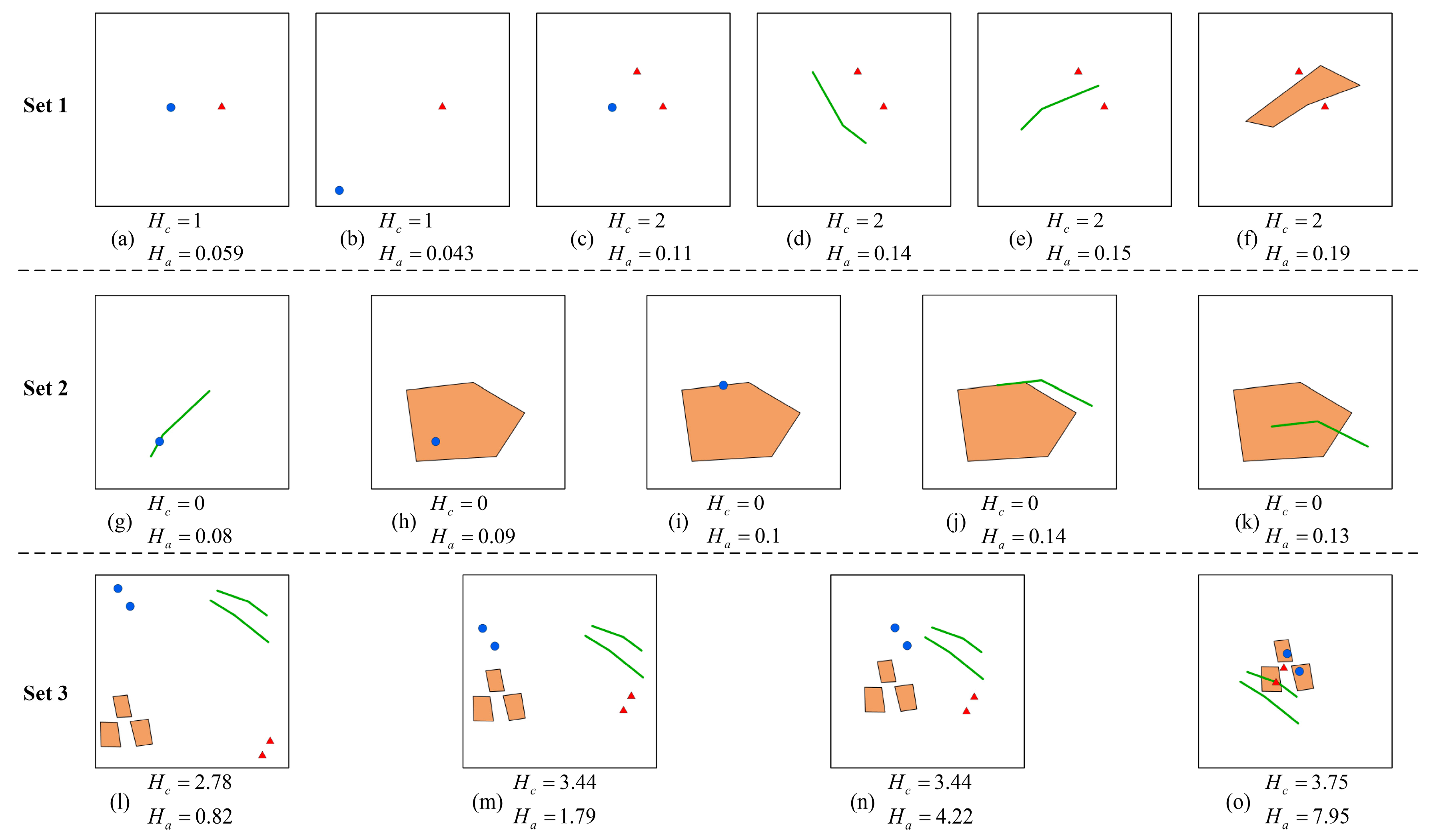
- Criterion 1, increase monotonically with respect to , mathematically:
- Criterion 2, increase with the number of , that is:
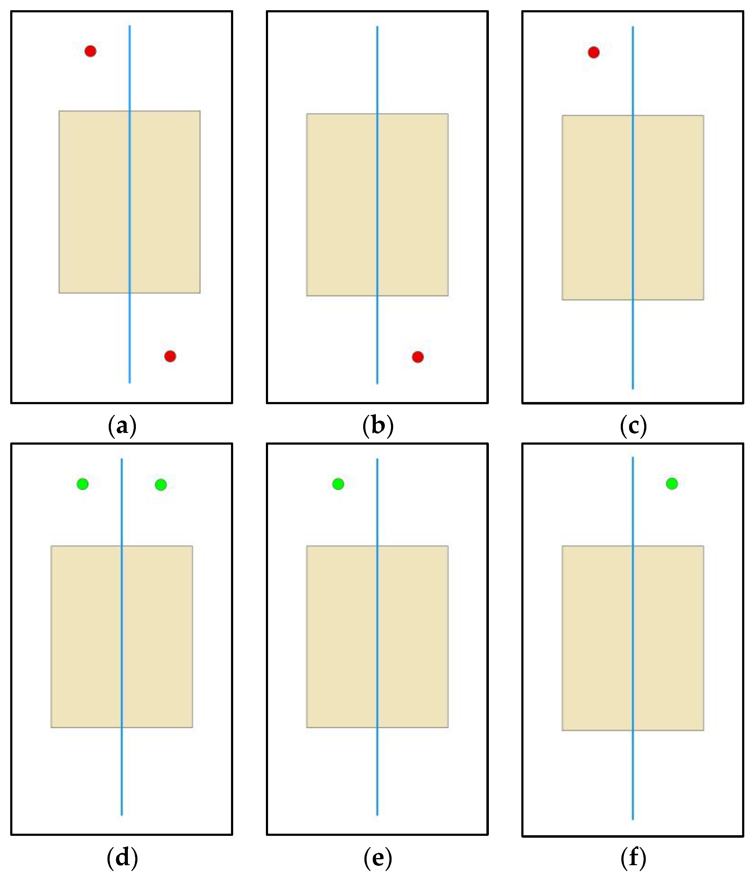
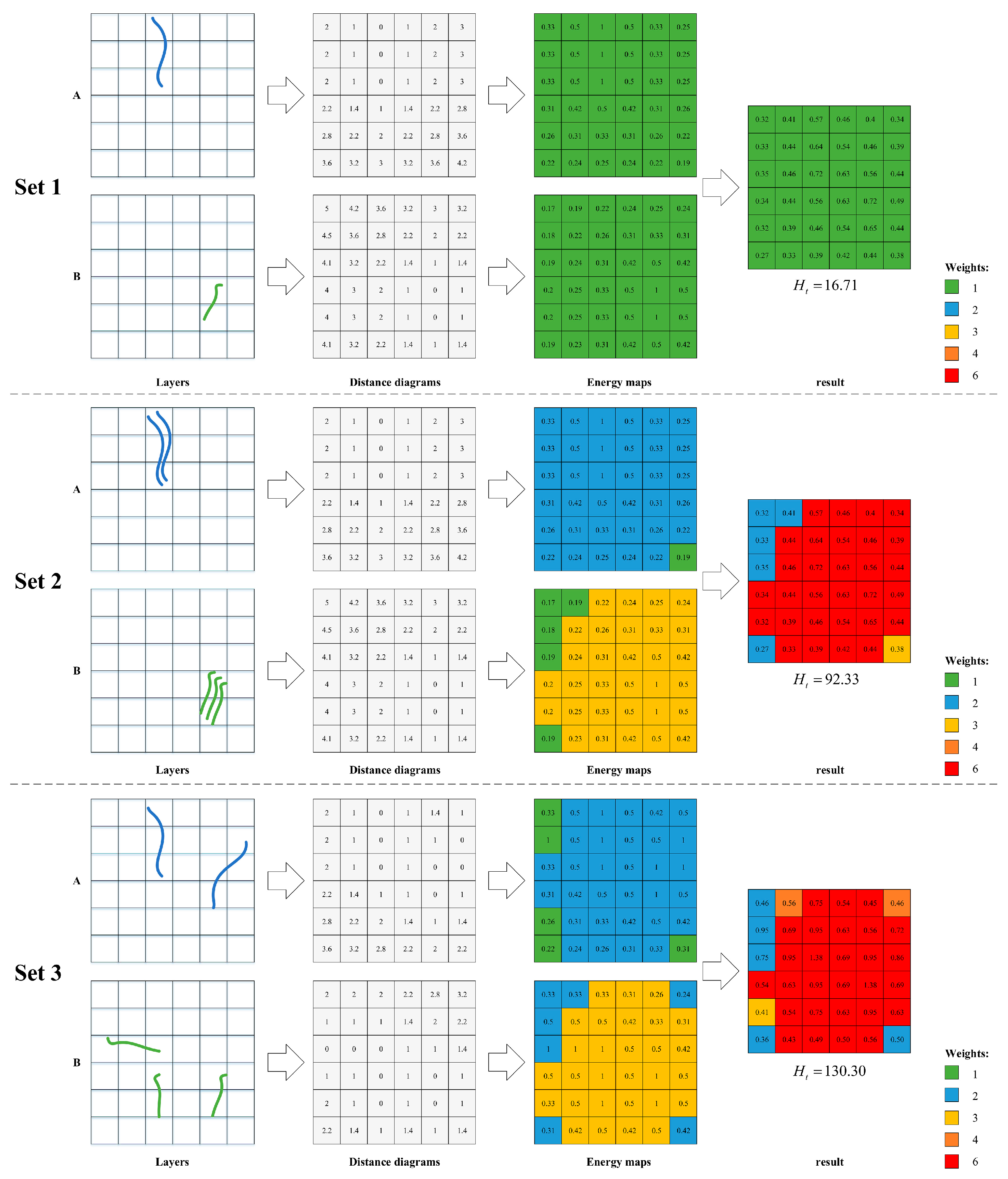
3. Methods
3.1. Generating the Energy Map and Weight Map
3.2. Measurement Process
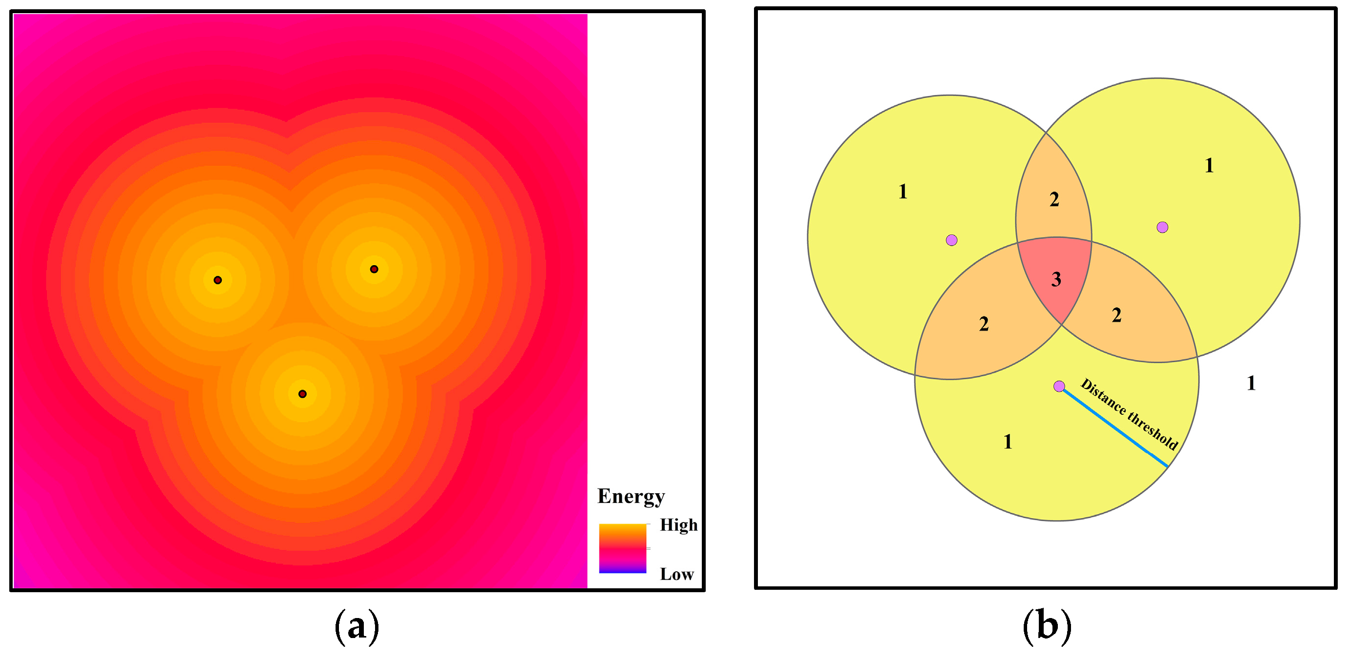
- Set an initial weight for each grid cell in the extent .
- Generate a buffer layer for each vector layer. The buffer size is defined as the longest distance that the influences from features should be considered. The buffer for a polygon is based on the polygon’s boundary, which is consistent with the approach to generate the energy field for a polygon.
- Set , and let denote the buffer layer for the vector layer . Then, divide the extent into areas according to the number of buffers in .
- Let be the number of buffers that cover the area . The weights of the grid cells inside the area are updated: .
- . Return to step 3 until all the buffer layers are traversed.
- Each grid cell will increase by a factor of in terms of their information amounts. Then, the total information is calculated by adding up the information in each grid cell.
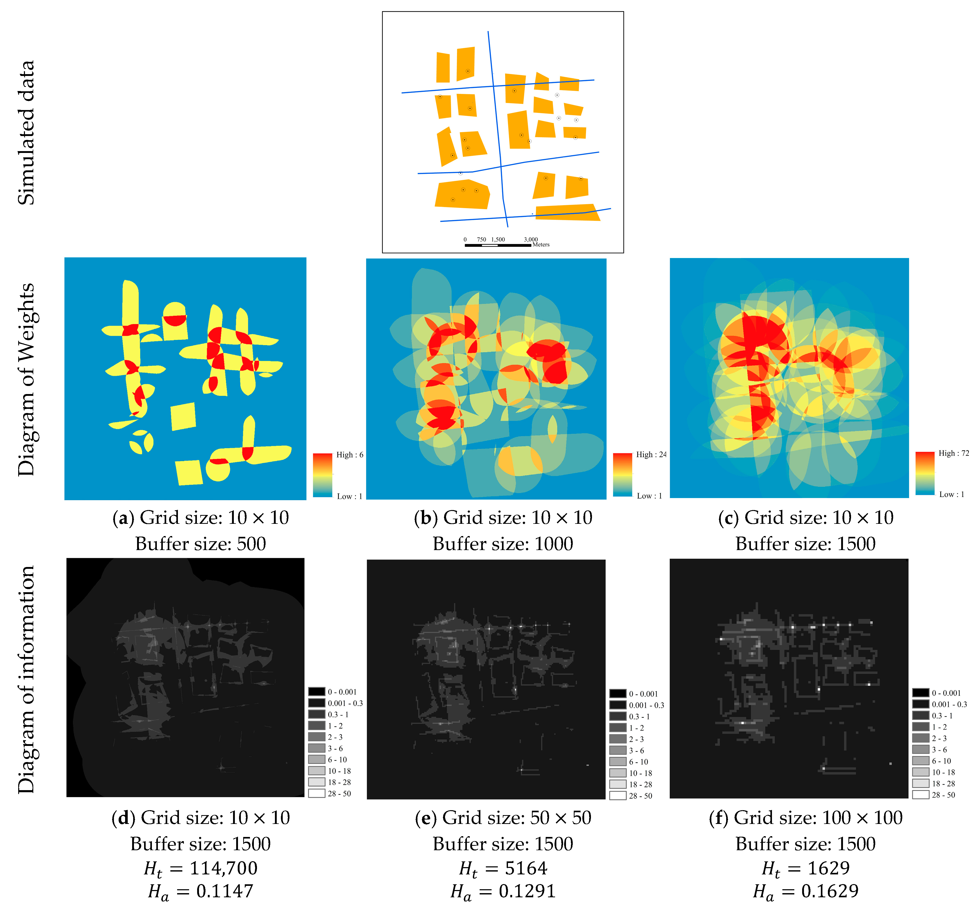
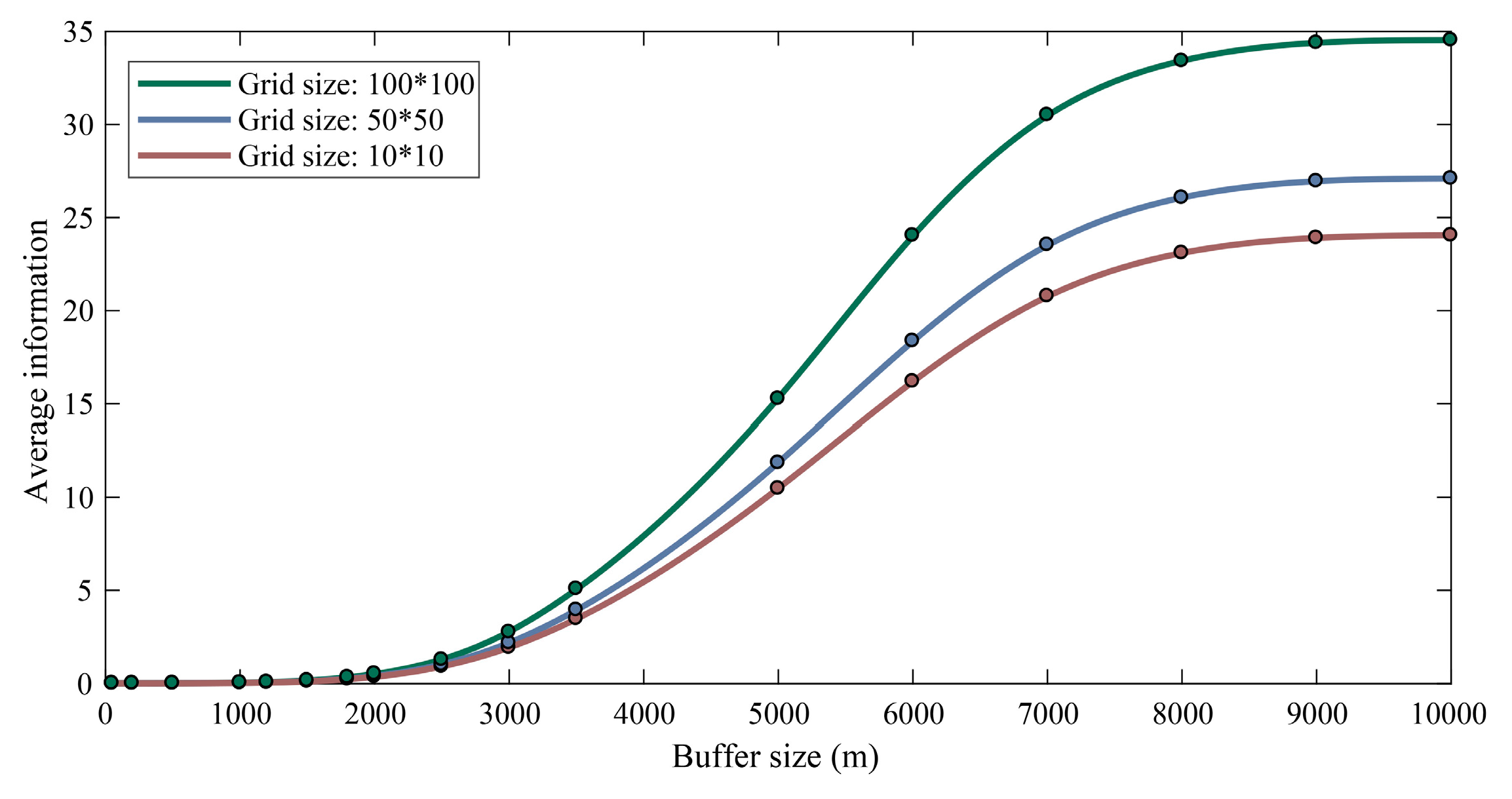
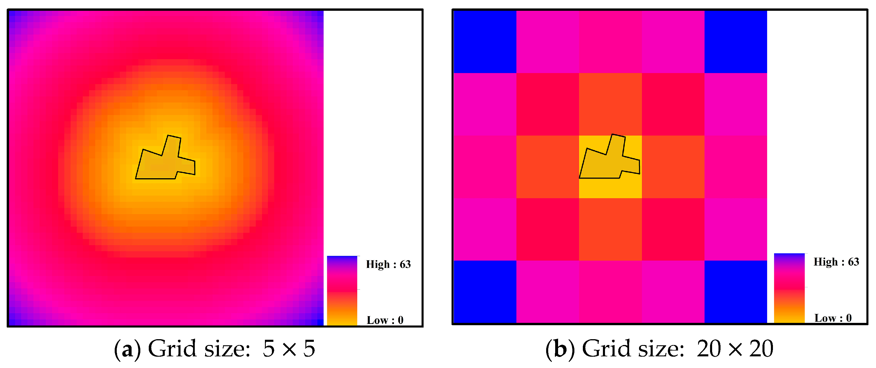
4. Experiments and Analysis
4.1. Sensitivity Analysis of the Grid Size and Buffer Size
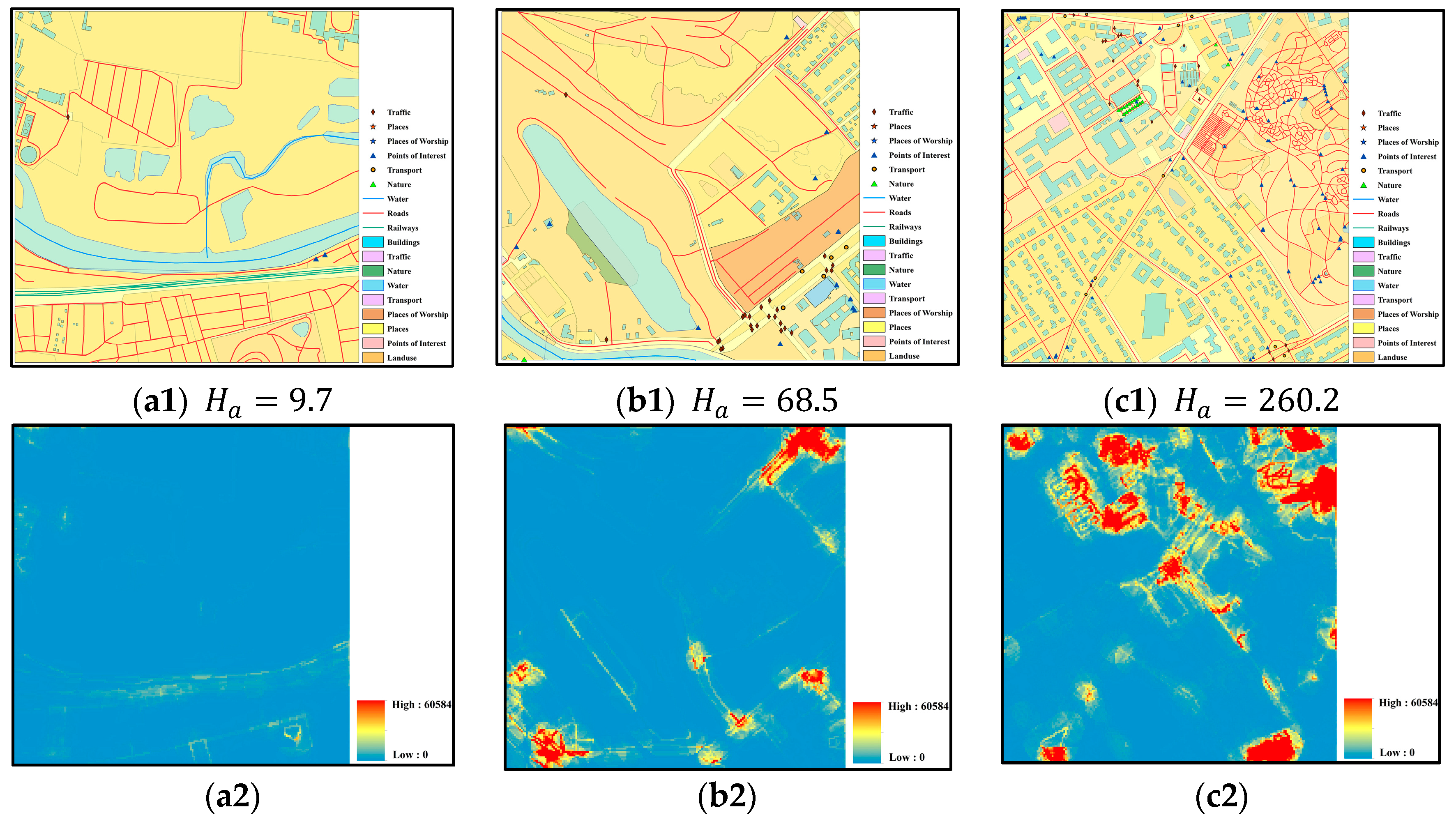
4.2. Validation Experiments
5. Discussion and Conclusions
Supplementary Materials
Acknowledgments
Author Contributions
Conflicts of Interest
References
- Batty, M.; Morphet, R.; Masucci, P.; Stanilov, K. Entropy, complexity, and spatial information. J. Geogr. Syst. 2014, 16, 363–385. [Google Scholar] [CrossRef] [PubMed]
- Fairbairn, D. Measuring Map Complexity. Cartogr. J. 2006, 43, 224–238. [Google Scholar] [CrossRef]
- Stein, A.; De Beurs, K. Complexity metrics to quantify semantic accuracy in segmented Landsat images. Int. J. Remote Sens. 2005, 26, 2937–2951. [Google Scholar] [CrossRef]
- Boots, B. Developing local measures of spatial association for categorical data. J. Geogr. Syst. 2003, 5, 139–160. [Google Scholar] [CrossRef]
- Chang, K.-T. Geographic Information System. Int. Encycl. Geogr. 2017, 1–9. [Google Scholar] [CrossRef]
- Egenhofer, M.J.; Sharma, J. Assessing the consistency of complete and incomplete topological information. Geogr. Syst. 1993, 1, 47–68. [Google Scholar]
- Li, Z.; Huang, P. Quantitative measures for spatial information of maps. Int. J. Geogr. Inf. Sci. 2002, 16, 699–709. [Google Scholar] [CrossRef]
- Renz, J. Qualitative Spatial Reasoning with Topological Information; Springer: Heidelberg, Germany, 2002; Volume 2293, p. 207. [Google Scholar]
- Frank, A.U. Qualitative Spatial Reasoning about Distance and Directions in Geographic Space. J. Vis. Lang. Comput. 1992, 3, 343–373. [Google Scholar] [CrossRef]
- Li, S. Combining topological and directional information for spatial reasoning. IJCAI 2007, 137, 435–440. [Google Scholar] [CrossRef]
- Shannon, C.E. A Mathematical Theory of Communication. Bell Labs Tech. J. 1948, 27, 379–423. [Google Scholar] [CrossRef]
- Shannon, C.E.; Weaver, W. The Mathematical Theory of Communication; University of Illinois Press: Champaign, IL, USA, 1949. [Google Scholar]
- Leibovici, D.G.; Claramunt, C.; Le Guyader, D.; Brosset, D. Local and global spatio-temporal entropy indices based on distance ratios and co-occurences distributions. Int. J. Geogr. Inf. Sci. 2014, 28, 29–41. [Google Scholar] [CrossRef]
- Batty, M. Space, scale, and scaling in entropy maximizing. Geogr. Anal. 2010, 42, 395–421. [Google Scholar] [CrossRef]
- Claramunt, C. A spatial form of diversity. Int. Conf. Spat. Inf. Theory 2005, 3693, 218–231. [Google Scholar] [CrossRef]
- Yu, H.; Winkler, S. Image complexity and spatial information. In Proceedings of the 2013 5th International Workshop on Quality of Multimedia Experience, Klagenfurt am Wörthersee, Austria, 3–5 July 2013; pp. 12–17. [Google Scholar]
- Harrie, L.; Stigmar, H.; Djordjevic, M. Analytical Estimation of Map Readability. ISPRS Int. J. Geoinf. 2015, 4, 418–446. [Google Scholar] [CrossRef]
- Hengl, T.; MacMillan, R.A.; Nikolić, M. Mapping efficiency and information content. Int. J. Appl. Earth Obs. Geoinf. 2013, 22, 127–138. [Google Scholar] [CrossRef]
- Jost, L. Entropy and diversity. Oikos 2006, 113, 363–375. [Google Scholar] [CrossRef]
- Chen, Y.; Sun, K. Information measurement of classification maps and scale effects. In Proceedings of the 2013 IEEE Conference Anthology, Chongqing, China, 1–8 January 2013. [Google Scholar] [CrossRef]
- Gao, P.; Zhang, H.; Li, Z. A hierarchy-based solution to calculate the configurational entropy of landscape gradients. Landsc. Ecol. 2017, 32, 1133–1146. [Google Scholar] [CrossRef]
- Hu, L.; He, Z.; Liu, J.; Zheng, C. Method for measuring the information content of terrain from digital elevation models. Entropy 2015, 17, 7021–7051. [Google Scholar] [CrossRef]
- Sukhov, V. Information capacity of a map entropy. Geod. Aerophotogr. 1967, 10, 212–215. [Google Scholar]
- Neumann, J. The Topological Information Content of a Map An Attempt at a Rehabilitation of Information Theory in Cartography. Int. J. Geogr. Inf. Geovis. 1994, 31, 26–34. [Google Scholar] [CrossRef]
- Bjørke, J.T. Framework for entropy-based map evaluation. Cartogr. Geogr. Inf. Sci. 1996, 23, 78–95. [Google Scholar] [CrossRef]
- Wang, S.; Wang, Z.; Du, Q. A measurement method of geometrical information considering multi-level map feature. Sci. Surv. Mapp. 2007, 32, 60–62. [Google Scholar]
- Wolpert, R.; Ickstadt, K. Poisson/gamma random field models for spatial statistics. Biometrika 1998, 85, 251–267. [Google Scholar] [CrossRef]
- Mai, P.M.; Beroza, G.C. A spatial random field model to characterize complexity in earthquake slip. J. Geophys. Res. Solid Earth 2002, 107, ESE 10-1–ESE 10-21. [Google Scholar] [CrossRef]
- Liu, X.; Wu, J.; Xu, J. Characterizing the risk assessment of heavy metals and sampling uncertainty analysis in paddy field by geostatistics and GIS. Environ. Pollut. 2006, 141, 257–264. [Google Scholar] [CrossRef] [PubMed]
- Chen, J.; Zhao, R.; Li, Z. Voronoi-based k-order neighbour relations for spatial analysis. ISPRS J. Photogramm. Remote Sens. 2004, 59, 60–72. [Google Scholar] [CrossRef]
- Long, Z.; Li, S. A complete classification of spatial relations using the Voronoi-based nine-intersection model. Int. J. Geogr. Inf. Sci. 2013, 27, 2006–2025. [Google Scholar] [CrossRef]
- Drysdale, R.L. Generalization of Voronoi Diagram In the plane. SIAM J. Comput. 1981, 10, 73–87. [Google Scholar]
- Tobler, W.R. A Computer Movie Simulating Urban Growth in the Detroit Region. Econ. Geogr. 1970, 46, 234. [Google Scholar] [CrossRef]
- Bartier, P.M.; Keller, C.P. Multivariate interpolation to incorporate thematic surface data using inverse distance weighting (IDW). Comput. Geosci. 1996, 22, 795–799. [Google Scholar] [CrossRef]
- Baczkowski, A.J.; Clark, I. Practical Geostatistics. J. R. Stat. Soc. Ser. A 1981, 144, 537. [Google Scholar] [CrossRef]
- Chen, J.; Li, C.; Li, Z.; Gold, C. A voronoi-based 9-intersection model for spatial relations. Int. J. Geogr. Inf. Sci. 2001, 15, 201–220. [Google Scholar] [CrossRef]
- Egenhofer, M.J.; Sharma, J. Topological relations between regions in ρ2 and Z2. In International Symposium on Spatial Databases; Springer: Berlin/Heidelberg, Germany, 1993; pp. 316–336. [Google Scholar]
- Guptill, S.C.; Morrison, J.L. Elements of Spatial Data Quality; Elsevier: Amsterdam, The Netherlands, 2013; Volume 1, ISBN 1483287947. [Google Scholar]
- Wang, J.-F.; Stein, A.; Gao, B.-B.; Ge, Y. A review of spatial sampling. Spat. Stat. 2012, 2, 1–14. [Google Scholar] [CrossRef]
- Tong, X.; Wang, Z.; Xie, H.; Liang, D.; Jiang, Z.; Li, J.; Li, J. Designing a two-rank acceptance sampling plan for quality inspection of geospatial data products. Comput. Geosci. 2011, 37, 1570–1583. [Google Scholar] [CrossRef]


© 2018 by the authors. Licensee MDPI, Basel, Switzerland. This article is an open access article distributed under the terms and conditions of the Creative Commons Attribution (CC BY) license (http://creativecommons.org/licenses/by/4.0/).
Share and Cite
Chen, P.; Shi, W. Measuring the Spatial Relationship Information of Multi-Layered Vector Data. ISPRS Int. J. Geo-Inf. 2018, 7, 88. https://doi.org/10.3390/ijgi7030088
Chen P, Shi W. Measuring the Spatial Relationship Information of Multi-Layered Vector Data. ISPRS International Journal of Geo-Information. 2018; 7(3):88. https://doi.org/10.3390/ijgi7030088
Chicago/Turabian StyleChen, Pengfei, and Wenzhong Shi. 2018. "Measuring the Spatial Relationship Information of Multi-Layered Vector Data" ISPRS International Journal of Geo-Information 7, no. 3: 88. https://doi.org/10.3390/ijgi7030088
APA StyleChen, P., & Shi, W. (2018). Measuring the Spatial Relationship Information of Multi-Layered Vector Data. ISPRS International Journal of Geo-Information, 7(3), 88. https://doi.org/10.3390/ijgi7030088