Parameters Derived from and/or Used with Digital Elevation Models (DEMs) for Landslide Susceptibility Mapping and Landslide Risk Assessment: A Review


Abstract
1. Introduction
1.1. Digital Elevation Models (DEMs)
1.2. Geo-Spatial Information Science and Disasters
“Ensure that all countries and international and regional organizations have access to and develop the capacity to use all types of space-based information to support the full disaster-management cycle.”
1.3. Landslide Hazards
2. DEMs Parameters Exploited for Landslide Hazards Risk Assessment
2.1. Slope (Angles, Gradient and Aspect)
2.2. Curvature
2.3. Topographic Position Index (TPI)
2.4. Topographic Wetness Index (TWI)
2.5. Topographic Roughness Index (TRI)
2.6. Sediment Transport Index (STI)
2.7. Stream Power Index (SPI)
3. Impact of Scale, Resolution and Accuracy of DEM on Parameters
4. Landslide Hazards Susceptible Mapping Based on DEM Parameters
5. Concluding Remarks and Future Perspectives
- Liquefaction is a phenomenon, usually triggered by the earthquakes and is considered as a disaster alone. Soil liquefaction is accompanied by the landslide events in hilly areas after an earthquake and depends on water quantity within the soil particles and soil type of that area [139]. Landslides occur in hilly areas, therefore it is a complicated task to attach ground water conditions to each cell in a DEM. Moreover, to achieve the true shape of hilly region, high resolution DEM is also necessary, which demands an abundance of field work to collect data for postulation of ground water conditions. Ground liquefaction is itself a disaster and related to groundwater conditions; therefore, we purpose that ground water condition can be an interesting conditioning factor or landslide inventory-parameter for susceptibility. It will be helpful if ground water or the landfill conditions are indexed with each cell of DEM for landslide risk assessments in the future.
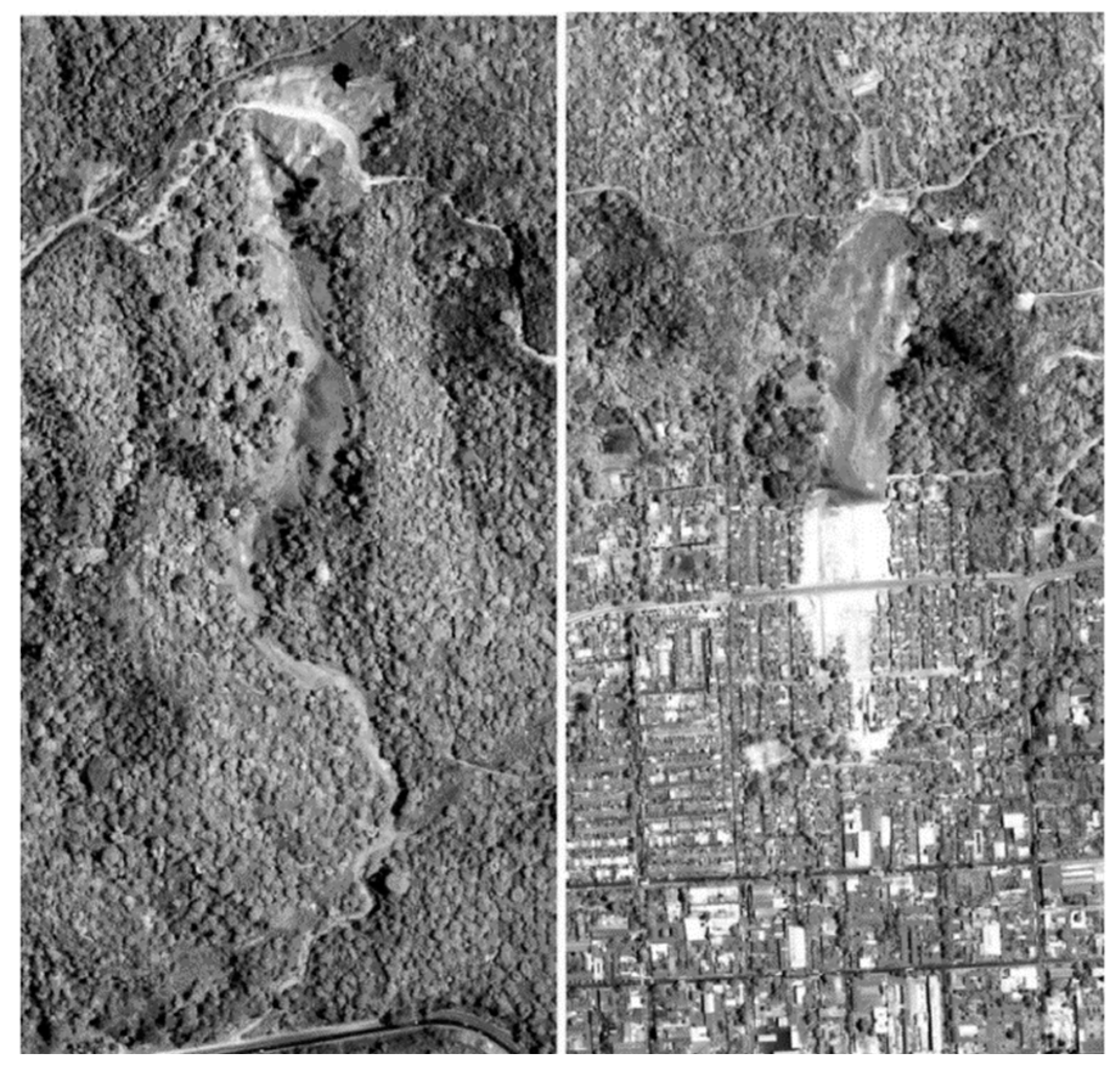
- Deforestation or cutting the existing plantations (change in land cover) might be a factor for impact assessment of landslide events to quantify spatial extent of landslide event. Therefore, deforestation information of an area that is likely to be hit by a landslide event should be used with the DEMs to ascertain the spatial extent of landslide debris movement in future. Deforestation rates in this particular region can be quantified and used with a DEM to assess the spatial-extent of landslide event before it occurs.
Author Contributions
Funding
Acknowledgments
Conflicts of Interest
References
- Terrain Analysis. Dictionary of Military and Associated Terms. 2005. Available online: https://www.thefreedictionary.com/terrain+analysis (accessed on 25 August 2019).
- Deng, Y.; Wilson, J.P.; Gallant, J.C. Chapter 23: Terrain Analysis. In The Handbook of Geographic Information Science, 1st ed.; Wilson, J.P., Fotheringham, A.S., Eds.; John Wiley & Sons: New York, NY, USA, 2008; pp. 417–435. [Google Scholar]
- Mutluoglu, O. Investigation of the effect of land slope on the accuracy of digital elevation model (DEM) generated from various sources. Sci. Res. Essays 2010, 5, 1384–1391. [Google Scholar]
- Toz, G.; Erdogan, M. DEM (Digital Elevation Model) Production and Accuracy Modeling of DEMs from 1: 35000 scale aerial photographs. In The International Archives of the Photogrammetry, Remote Sensing and Spatial Information Sciences; ISPRS: Beijing, China, 2008; Volume XXXVI, pp. 775–780. [Google Scholar]
- Yakar, M. Digital Elevation Model Generation by Robotic Total Station Instrument. Soc. Exp. Mech. 2009, 33, 52–59. [Google Scholar] [CrossRef]
- Li, X.; Shen, H.; Feng, R.; Li, J.; Zhang, L. DEM generation from contours and a low-resolution DEM. ISPRS J. Photogramm. Remote Sens. 2017, 134, 135–147. [Google Scholar] [CrossRef]
- USGS. Available online: https://www.usgs.gov/ (accessed on 14 August 2019).
- Taud, H.; Parrot, J.; Alvarez, R. DEM generation by contour line dilation p. Comput. Geosci. 1999, 25, 775–783. [Google Scholar] [CrossRef]
- Li, Z.; Gold, Q.Z.C. Digital Terrain Modeling: Principles and Methodology; CRC Press: New York, NY, USA, 2005. [Google Scholar]
- Peralvo, M. Influence of DEM interpolation methods in drainage analysis. GIS Water Resour. 2004, 4, 26. [Google Scholar]
- Vaze, J.; Teng, J. High‐resolution LiDAR DEM: How good is it? In Proc. MODSIM 2007: Intl. Congress on Modelling and Simulation, 692-698. L. Oxley and D. Kulasiri, eds. Modelling and Simulation Society of Australia and New Zealand. 2007. Available online: www.mssanz.org.au/MODSIM07/ papers/12_s27/HighResolution_s27_Vaze_.pdf (accessed on 1 January 2019).
- Arrighi, P.; Soille, P. From scanned topographic maps to digital elevation models. In International Symposium on Imaging Applications in Geology; Jongmans, D., Pirard, E., Trefois, P., Eds.; Liege, Belgium, 1999; pp. 1–4. [Google Scholar]
- Carter, J.R. Digital Representations of Topographic Surfaces. Photogramm. Eng. Remote Sens. 1988, 54, 1577–1580. [Google Scholar]
- Soycan, A.; Soycan, M. Digital Elevation Model Production from Scanned Topographic conotur maps via Thin Plate Spline Interpolation. Arab. J. Sci. Eng. 2009, 34, 121–134. [Google Scholar]
- Oky, P.; Yokoyama, D.A.R. DEM generation method from contour lines based on the steepest slope segment chain and a monotone interpolation function. ISPRS J. Photogramm. Remote Sens. 2002, 57, 86–101. [Google Scholar]
- NASA JPL ASTER. Available online: https://asterweb.jpl.nasa.gov/gdem.asp (accessed on 5 October 2019).
- Farr, T.G.; Rosen, P.A.; Caro, E.; Crippen, R.; Duren, R.; Hensley, S.; Kobrick, M.; Paller, M.; Rodriguez, E.; Roth, L.; et al. The Shuttle Radar Topography Mission. Rev. Geophys. 2007, 45, 1–33. [Google Scholar] [CrossRef]
- USGS. EROS Archive. Available online: https://www.usgs.gov/centers/eros/science/usgs-eros-archive-digital-elevation-global-30-arc-second-elevation-gtopo30?qt-science_center_objects=0#qt-science_center_objects (accessed on 5 October 2019).
- Visser, P.N.A.M. Gravity field determination with GOCE and GRACE. Adv. Sp. Res. 1999, 23, 771–776. [Google Scholar] [CrossRef]
- NGA. Available online: https://www.nga.mil/ProductsServices/GeodesyandGeophysics/Pages/EarthGravityModel.aspx (accessed on 5 October 2019).
- Balmino, G.; Vales, N.; Briais, S.B.A. Spherical harmonic modelling to ultra-high degree of Bouguer and isostatic anomalies. J. Geod. 2011, 86, 499–520. [Google Scholar] [CrossRef]
- Wang, T.; Belle, I.; Hassler, U. Modelling of Singapore s topographic transformation based on DEMs. Geomorphology 2015, 231, 367–375. [Google Scholar] [CrossRef]
- Fisher, P.F.; Tate, N.J. Causes and consequences of error in digital elevation models. Prog. Phys. Geogr. 2006, 30, 467–489. [Google Scholar] [CrossRef]
- Mercer, B. DEMs created from airborne IFSAR–An update. Int. Arch. Photogramm. Remote Sens. 2004, 35, 242–248. [Google Scholar]
- Hahn, M.; Samadzadegan, F. Integration of DTMs using wavelets. Int. Arch. Photogramm. Remote Sens. 1999, 32, 3–4. [Google Scholar]
- Weng, Q. Quantifying Uncertainty of Digital Elevation Models Derived from Topographic Maps. In Symposium on Advances in Spatial Data Handling; Richardson, D., van Oosterom, P., Eds.; Springer: Berlin/Heidelberg, Germany, 2002; pp. 403–418. [Google Scholar]
- Chang, H.; Ge, L.; Rizos, C. Assessment of digital elevation models using RTK GPS. J. Geospatial Eng. 2004, 6, 1–8. [Google Scholar]
- Webster, T.L.; Murphy, J.B.; Gosse, J.C.; Spooner, I. The application of lidar-derived digital elevation model analysis to geological mapping: An example from the Fundy Basin, Nova Scotia, Canada. Can. J. Remote Sens. 2006, 32, 173–193. [Google Scholar] [CrossRef]
- Zhang, C.; Fraser, C. Generation of Digital Surface Model From High Resolution. In The International Archives of the Photogrammetry, Remote Sensing and Spatial Information Sciences; ISPRS: Beijing, China, 2008; Volume XXXVI, pp. 785–790. [Google Scholar]
- Capaldo, P.; Crespi, M.; Fratarcangeli, F.; Nascetti, A.; Francesca, P.; Agugiaro, G.; Poli, D.; Remondino, F. DSM Generation from Optical and SAR high resolution satellite Imagery: Methodology, Problems and Potentialities. In Proceedings of the International Geoscience Remote Sensing Symposium (IGARSS), Munich, Germany, 22–27 July 2012; pp. 6936–6939. [Google Scholar]
- Mohd, W.M.; Abdullah, M.A.; Hashim, S. Evaluation of Vertical Accuracy of Digital Elevation Models Generated from Different Sources: Case Study of Ampang and Hulu Langat, Malaysia. FIG Congress 2014, XXV, 1–17. [Google Scholar]
- Wu, B.; Tang, S.; Zhu, Q.; Tong, K.; Hu, H.; Li, G. Geometric integration of high-resolution satellite imagery and airborne LiDAR data for improved geopositioning accuracy in metropolitan areas. ISPRS J. Photogramm. Remote Sens. 2015, 109, 139–151. [Google Scholar] [CrossRef]
- Yu, M.; Huang, Y.; Xu, Q.; Guo, P.; Dai, Z. Application of virtual earth in 3D terrain modeling to visual analysis of large-scale geological disasters in mountainous areas. Environ. Earth Sci. 2016, 75, 562–568. [Google Scholar] [CrossRef]
- Leitão, J.P.; de Sousa, L.M. Towards the optimal fusion of high-resolution Digital Elevation Models for detailed urban flood assessment. J. Hydrol. 2018, 561, 651–661. [Google Scholar] [CrossRef]
- Akturk, E.; Altunel, A.O. Accuracy Assesment of a Low-Cost UAV Derived Digital Elevation Model (DEM) in a Highly Broken and Vegetated Terrain. Measurement 2018, 136, 382–386. [Google Scholar] [CrossRef]
- UNITED NATIONS-SPIDER. Available online: https://www.un-spider.org (accessed on 20 August 2019).
- UNITED NATIONS-OOSA. Available online: https://www.unoosa.org (accessed on 18 August 2019).
- Altan, O.; Backhause, R.; Boccardo, P.; van Manen, N.; Trinder, J.; Zlatanova, S. The Value of Geoinformation for Disaster Risk Management (VALID) Benefit Analysis Stakeholder Assessment, 1st ed.; Joint Board of Geospatial Information Societies (JBGIS): Copenhagen, Denmark, 2013. [Google Scholar]
- Altan, O. Use of Photogrammetry, Remote Sensing and Spatial Information Technologies in Disaster Management, especially Earthquakes. In Geo-Information for Disaster Management; van Oosterom, F.E.M., Zlatanova, S.P., Eds.; Springer: Berlin/Heidelberg, Germany, 2005. [Google Scholar]
- Li, D.; Shan, J.; Shao, Z.; Zhou, X.; Yao, Y. Geomatics for smart cities-concept, key techniques, and applications. Geo-Spatial Inf. Sci. 2013, 16, 13–24. [Google Scholar] [CrossRef]
- Li, D.; Shao, Z. The new era for geo-information. Sci. China Ser. F Inf. Sci. 2009, 52, 1233–1242. [Google Scholar] [CrossRef]
- Kocaman, S.; Gokceoglu, C. A CitSci app for landslide data collection. Landslides 2019, 16, 611–615. [Google Scholar] [CrossRef]
- Shao, Z.; Fu, H.; Li, D.; Altan, O.; Cheng, T. Remote sensing monitoring of multi-scale watersheds impermeability for urban hydrological evaluation. Remote Sens. Environ. 2019, 232, 111338. [Google Scholar] [CrossRef]
- Li, D.; Yao, Y.; Shao, Z.; Wang, L. From digital Earth to smart Earth. Chin. Sci. Bull. 2014, 59, 722–733. [Google Scholar] [CrossRef]
- Erasmi, S.; Rosenbauer, R.; Buchbach, R.; Busche, T.; Rutishauser, S. Evaluating the quality and accuracy of TanDEM-X digital elevation models at archaeological sites in the Cilician Plain, Turkey. Remote Sens. 2014, 6, 9475–9493. [Google Scholar] [CrossRef]
- Alganci, U.; Besol, B.; Sertel, E. Accuracy Assessment of Different Digital Surface Models. ISPRS Int. J. Geo-Inf. 2018, 7, 114. [Google Scholar] [CrossRef]
- Li, D.; Ma, J.; Cheng, T.; Genderen, J.L.V.; Shao, Z. Challenges and opportunities for the development of MEGACITIES. Int. J. Digit. Earth 2018, 12, 1382–1395. [Google Scholar] [CrossRef]
- IFRC. Available online: https://www.ifrc.org/en/what-we-do/disaster-management/about-disasters/what-is-a-disaster/ (accessed on 24 August 2019).
- Cruden, M.D. A Simple Definition of a Landslide. Int. Assoc. Eng. Geol. 1991, 43, 27–29. [Google Scholar] [CrossRef]
- Nadim, F.; Kjekstad, O.; Peduzzi, P.; Herold, C.; Jaedicke, C. Global landslide and avalanche hotspots. Landslides 2006, 3, 159–173. [Google Scholar] [CrossRef]
- Gorum, T.; Fan, X.; van Westen, C.J.; Huang, R.Q.; Xu, Q.; Tang, C.; Wang, G. Geomorphology Distribution pattern of earthquake-induced landslides triggered by the 12 May 2008 Wenchuan earthquake. Geomorphology 2011, 133, 152–167. [Google Scholar] [CrossRef]
- Crosta, G.; Imposimato, S.; Roddeman, D.; Chiesa, S.; Moia, F. Small fast-moving flow-like landslides in volcanic deposits: The 2001 Las Colinas Landslide (El Salvador). Eng. Geol. 2005, 79, 185–214. [Google Scholar] [CrossRef]
- Chigira, M.; Wu, X.; Inokuchi, T.; Wang, G. Landslides induced by the 2008 Wenchuan earthquake, Sichuan, China. Geomorphology 2010, 118, 225–238. [Google Scholar] [CrossRef]
- Scientific Visualization Studio (NASA). Available online: https://svs.gsfc.nasa.gov/4710 (accessed on 31 August 2019).
- Moore, I.D.; Grayson, R.B.; Ladson, A.R. Digital Terrain Modeling: A review of Hydrological, Geomorphological and Biological applications. Hydrol. Process. 1991, 5, 3–30. [Google Scholar] [CrossRef]
- Wolock, D.; Price, C.V. Effect of Digital Elevation Model Map Scale and Data Resolution on a Topography-Based Watershed Model. Water Resour. Res. 1994, 30, 3041–3052. [Google Scholar] [CrossRef]
- Lee, E.M.; Jones, D.K.C. Landslide Risk Assessment, 1st ed.; Thomas Telford Publishing: London, UK; 1 Heron Quay: London, UK, 2004. [Google Scholar]
- Gao, J. Identification of topographic settings conducive to landsliding from DEM in Nelson county, Virginia, U.S.A. Earth Surf. Process. Landf. 1993, 18, 579–591. [Google Scholar] [CrossRef]
- Cardinali, M.; Reichenbach, P.; Guzzetti, F.; Ardizzone, F.; Antonini, G.; Galli, M.; Cacciano, M.; Castellani, M.; Salvati, P. System Sciences A geomorphological approach to the estimation of landslide hazards and risks in Umbria, Central Italy. Nat. Hazards Earth Syst. Sci. 2002, 2, 57–72. [Google Scholar] [CrossRef]
- Costanzo, D.; Rotigliano, E.; Irigaray, C.; Jim, J.D. Factors selection in landslide susceptibility modelling on large scale following the gis matrix method: Application to the river Beiro basin (Spain). Nat. Hazards Earth Syst. Sci. 2012, 12, 327–340. [Google Scholar] [CrossRef]
- Fenton, G.A.; McLean, A.; Nadim, F.; Griffiths, D.V. Landslide hazard assessment using digital elevation models. Can. Geotech. J. 2013, 50, 620–631. [Google Scholar] [CrossRef]
- Lines, F. Chapter 5: Curvature. In Geometry for Naval Architects, 1st ed.; Biran, A., Ed.; Elsevier Ltd.: Amsterdam, The Netherlands, 2019; pp. 223–257. [Google Scholar]
- Stump, S. Secondary Mathematics Teachers’ Knowledge of Slope. Math. Educ. Res. J. 1999, 11, 124–144. [Google Scholar] [CrossRef]
- Horn, B.K.P. Understanding Image Intensities. Artif. Intell. 1977, 8, 201–231. [Google Scholar] [CrossRef]
- Horn, B.K.P. Hill Shading and the Reflectance Map. Proc. IEEE 1981, 69, 14–47. [Google Scholar] [CrossRef]
- Burrough, P.A. Principles of Geographical Information Systems for Land Resources Asessment, 1st ed.; Clarendon Press: Oxford, UK, 1986. [Google Scholar]
- Skidmore, A.K. A comparison of techniques for calculating gradient and aspect from a gridded digital elevation model. Int. J. Geogr. Inf. Syst. 1989, 3, 323–334. [Google Scholar] [CrossRef]
- Raaflaub, L.D.; Collins, M.J. The effect of error in gridded digital elevation models on the estimation of topographic parameters. Environ. Model. Softw. 2006, 21, 710–732. [Google Scholar] [CrossRef]
- Mclean, A. Landslide Risk Assessment Using Digital Elevation Models; Dalhousie University: Halifax, NS, Canada, 2011. [Google Scholar]
- Zevenbergen, L.W.; Thorne, C.R. Quantitative Analysis of Land Surface Topography. Earth Surf. Dyn. 1987, 12, 47–56. [Google Scholar] [CrossRef]
- Lee, S.; Ryu, J.H.; Won, J.S.; Park, H.J. Determination and application of the weights for landslide susceptibility mapping using an artificial neural network. Eng. Geol. 2004, 71, 289–302. [Google Scholar] [CrossRef]
- Rasyid, A.R.; Bhandary, N.P.; Yatabe, R. Performance of frequency ratio and logistic regression model in creating GIS based landslides susceptibility map at Lompobattang Mountain, Indonesia. Geoenvironmental Disasters 2016, 3, 1–16. [Google Scholar] [CrossRef]
- ArcMap: Curvature Function. Available online: http://desktop.arcgis.com/en/arcmap/10.3/manage-data/raster-and-images/curvature-function.htm (accessed on 28 August 2019).
- Guisan, A.; Weiss, S.B.; Weiss, A.D. GLM versus CCA spatial modeling of plant species distribution. Plant Ecol. 1999, 143, 107–122. [Google Scholar] [CrossRef]
- Weiss, A.D. Topographic Position and Landforms Analysis. In Proceedings of the Poster Presentation at ESRI User Conference, Seattle, WA, USA, 22–24 January 2001. [Google Scholar]
- Jebur, M.N.; Pradhan, B.; Tehrany, M.S. Remote Sensing of Environment Optimization of landslide conditioning factors using very high-resolution airborne laser scanning (LiDAR) data at catchment scale. Remote Sens. Environ. 2014, 152, 150–165. [Google Scholar] [CrossRef]
- Oh, H.; Kadavi, P.R.; Lee, C.; Lee, S. Evaluation of landslide susceptibility mapping by evidential belief function, logistic regression and support vector machine models. Geomatics, Nat. Hazards Risk 2018, 9, 1053–1070. [Google Scholar] [CrossRef]
- Jenness, J.; Brost, B.; Beier, P. Land Facet Corridor Designer. USDA Forest Service Rocky Mountain Research Station: Flagstaff, AZ, USA, 2013. [Google Scholar]
- Enterprises, J. 2019. Available online: http://www.jennessent.com/arcgis/arcgis_extensions.htm (accessed on 8 September 2019).
- Jiang, L.; Ling, D.; Zhao, M.; Wang, C.; Liang, Q.; Liu, K. Effective Identification of Terrain Positions from Gridded DEM Data Using Multimodal Classification Integration. ISPRS Int. J. Geo-Inf. 2018, 7, 443. [Google Scholar] [CrossRef]
- Grabs, T.; Seibert, J.; Bishop, K.; Laudon, H. Modeling spatial patterns of saturated areas: A comparison of the topographic wetness index and a dynamic distributed model. J. Hydrol. 2009, 373, 15–23. [Google Scholar] [CrossRef]
- Grimm, K.; Nasab, M.T.; Chu, X. TWI Computations and Topographic Analysis of Depression-Dominated Surfaces. Water 2018, 10, 663. [Google Scholar] [CrossRef]
- Beven, K.J.; Kirkby, M.J. A physically based, variable contributing area model of basin hydrology/Un modèle à base physique de zone d’appel variable de l’hydrologie du bassin versant. Hydrol. Sci. Bull. 1979, 24, 43–69. [Google Scholar] [CrossRef]
- Schmidt, F. Comparison of DEM Data Capture and Topographic Wetness Indices. Precis. Agric. 2003, 4, 179–192. [Google Scholar] [CrossRef]
- Gu, A.; Seibert, J. Modeling Spatial Patterns of Saturated Areas: An Evaluation of Different Terrain Indices. Water Resour. Res. 2004, 40, 114–133. [Google Scholar]
- Sørensen, R.; Zinko, U.; Seibert, J.; Sørensen, R.; Zinko, U.; On, J.S. On the calculation of the topographic wetness index: Evaluation of different methods based on field observations. Hydrol. Earth Syst. Sci. Discuss. Eur. Geosci. Union 2006, 10, 101–112. [Google Scholar] [CrossRef]
- Zhu, C.Q.A.; Pei, T.; Thomas, B.L. An approach to computing topographic wetness index based on maximum downslope gradient. Precis. Agric. 2011, 12, 32–43. [Google Scholar]
- Buchanan, B.P.; Fleming, M.; Schneider, R.L.; Richards, B.K.; Archibald, J.; Qiu, Z.; Walter, M.T. Evaluating topographic wetness indices across central New York agricultural landscapes. Hydrol. Earth Syst. Sci. 2014, 18, 3279–3299. [Google Scholar] [CrossRef]
- Smith, M.W. Roughness in the Earth Sciences. Earth Sci. Rev. 2014, 136, 202–225. [Google Scholar] [CrossRef]
- Korzeniowska, K.; Korup, O. Mapping Gullies Using Terrain-Surface Roughness. In Proceedings of the 19th AGILE conference on Geographic Information Science, Helsinki, Finland, 14–17 June 2016. [Google Scholar]
- Riley, J.S.; de Gloria, D.S.; Elliot, R. Terrain Ruggedness Index that Quantifies Topographic Heterogeneity. Intermt. J. Sci. 1999, 5, 23–27. [Google Scholar]
- Shepard, M.K.; Campbell, B.A.; Bulmer, M.H.; Farr, T.G.; Gaddis, L.R.; Plaut, J.J. A planetary and remote sensing perspective. J. Geophys. Res. 2001, 106, 777–795. [Google Scholar] [CrossRef]
- Frankel, K.L.; Dolan, J.F. Characterizing arid region alluvial fan surface roughness with airborne laser swath mapping digital topographic data. J. Geophys. Res. 2007, 112, 1–14. [Google Scholar] [CrossRef]
- Cavalli, M.; Marchi, L. Characterisation of the surface morphology of an alpine alluvial fan using airborne LiDAR. Nat. Hazards Earth Syst. Sci. 2008, 8, 323–333. [Google Scholar] [CrossRef]
- Wenjie, L.; Danxun, L.; Xingkui, W. An approach to estimating sediment transport capacity of overland flow. Sci. China Technol. Sci. 2011, 54, 2649–2656. [Google Scholar]
- Moore, I.D.; Burch, G.J. Sediment Transport Capacity of Sheet and Rill Flow: Application of Unit Stream Power Theory. Water Resour. Res. 1986, 22, 1350–1360. [Google Scholar] [CrossRef]
- Moore, I.D.; Wilson, J.P. Length-slope factors for the Revised Universal Soil Loss Equation: Simplified method of estimation. J. Soil Water Conserv. 1992, 47, 423–428. [Google Scholar]
- Tayfur, G. Applicability of sediment transport capacity models for nonsteady state erosion from steep slopes. J. Hydrol. Eng. 2002, 7, 252–259. [Google Scholar] [CrossRef]
- Chandra, K.; Amar, D.; Regmi, D.; Reza, H.; Althuwaynee, O.F. Landslide susceptibility mapping using certainty factor, index of entropy and logistic regression models in GIS and their comparison at Mugling –Narayanghat road section in Nepal Himalaya. Nat. Hazards 2013, 65, 135–165. [Google Scholar]
- Wang, Q.; Li, W.; Wu, Y.; Pei, Y.; Xie, P. Application of statistical index and index of entropy methods to landslide susceptibility assessment in Gongliu (Xinjiang, China). Environ. Earth Sci. 2016, 75, 598–610. [Google Scholar] [CrossRef]
- Moore, I.D. A Contour-based Topographic Model for Hydrological and Ecological Applications. Earth Surf. Process. Landf. 1988, 13, 305–320. [Google Scholar] [CrossRef]
- Pradhan, B.; Sezer, E.A.; Gokceoglu, C.; Buchroithner, M.F. Landslide susceptibility mapping by neuro-fuzzy approach in a landslide-prone area (Cameron Highlands, Malaysia). IEEE Trans. Geosci. Remote Sens. 2010, 48, 4164–4177. [Google Scholar] [CrossRef]
- Pawluszek, K.; Borkowski, A. Impact of DEM-derived factors and analytical hierarchy process on landslide susceptibility mapping in the region of Roznow Lake, Poland. Nat. Hazards 2016, 86, 919–952. [Google Scholar] [CrossRef]
- Yilmaz, I. Landslide susceptibility mapping using frequency ratio, logistic regression, artificial neural networks and their comparison: A case study from Kat landslides (Tokat—Turkey). Comput. Geosci. 2009, 35, 1125–1138. [Google Scholar] [CrossRef]
- Juliev, M.; Mergili, M.; Mondal, I.; Nurtaev, B.; Pulatov, A.; Hübl, J. Comparative analysis of statistical methods for landslide susceptibility mapping in the Bostanlik District, Uzbekistan. Sci. Total Environ. 2019, 653, 801–814. [Google Scholar] [CrossRef]
- Lee, S.; Talib, J.A. Probabilistic landslide susceptibility and factor effect analysis. Environ. Geol. 2005, 47, 982–990. [Google Scholar] [CrossRef]
- Oh, H.; Park, N.; Lee, S.; Lee, S. Extraction of landslide-related factors from ASTER imagery and its application to landslide susceptibility mapping. Int. J. Remote Sens. 2012, 33, 3211–3231. [Google Scholar] [CrossRef]
- Dlugosz, M. Digital Terrain Model (DTM) As a Tool for Landslide Investigation in the Polish Carpathians. Versita 2012, XLVI, 5–23. [Google Scholar]
- Pradhan, B.; Sameen, M.I. Effects of the Spatial Resolution of Digital Elevation Models and their Products on Landslide Susceptibility Mapping. Laser Scanning Appl. Landslide Assess. 2017, 2, 133–150. [Google Scholar]
- Deng, Y.; Wilson, J.P.; Bauer, B.O. DEM resolution dependencies of terrain attributes across a landscape. Int. J. Geogr. Inf. Sci. 2007, 21, 187–213. [Google Scholar] [CrossRef]
- Vaze, J.; Teng, J.; Spencer, G. Impact of DEM accuracy and resolution on topographic indices. Environ. Model. Softw. 2010, 25, 1086–1098. [Google Scholar] [CrossRef]
- Chow, T.E.; Hodgson, M.E. Effects of lidar post-spacing and DEM resolution to mean slope estimation. Int. J. Geogr. Inf. Sci. 2009, 23, 1277–1295. [Google Scholar] [CrossRef]
- Ciampalini, A.; Raspini, F.; Frodella, W.; Bardi, F.; Bianchini, S.; Moretti, S. The effectiveness of high-resolution LiDAR data combined with PSInSAR data in landslide study. Landslides 2016, 13, 399–410. [Google Scholar] [CrossRef]
- Pesci, A.; Baldi, P.; Bedin, A.; Casula, G.; Cenni, N.; Fabris, M.; Loddo, F.; Mora, P.; Bacchetti, M. Digital elevation models for landslide evolution monitoring: Application on two areas located in the Reno River Valley (Italy). Ann. Geophys. 2004, 47, 1339–1353. [Google Scholar]
- Mahalingam, R.; Olsen, M.J.; Banion, M.S.O. Evaluation of landslide susceptibility mapping techniques using lidar-derived conditioning factors (Oregon case study). Geomat. Nat. Hazards Risk 2016, 7, 1884–1907. [Google Scholar] [CrossRef]
- Chang, K.T.; Dou, J.; Chang, Y.; Kuo, C.P.; Xu, K.M.; Liu, J.K. Spatial resolution effects of digital terrain models on landslide susceptibility analysis. In The International Archives of the Photogrammetry, Remote Sensing Spatial Information Sciences; Halounova, L., Šafář, V., Raju, P.L.N., Plánka, L., Ždímal, V., Srinivasa Kumar, T., Faruque, F.S., Kerr, Y., Ramasamy, S.M., Comiso, J., et al., Eds.; ISPRS Archives: Prague, Czech Republic, 2016; Volume XLI-B8, pp. 33–36. [Google Scholar]
- Wang, B.; Shi, W.; Liu, E. Robust methods for assessing the accuracy of linear interpolated DEM. Int. J. Appl. Earth Obs. Geoinf. 2015, 34, 198–206. [Google Scholar] [CrossRef]
- Carrara, A.; Guzzetti, F.; Cardinali, M.; Reichenbach, P. Use of GIS Technology in the Prediction and Monitoring of Landslide Hazard. Nat. Hazards 1999, 20, 117–135. [Google Scholar] [CrossRef]
- Ercanoglu, M.; Gokceoglu, C. Use of fuzzy relations to produce landslide susceptibility map of a landslide prone area (West Black Sea Region, Turkey). Eng. Geol. 2004, 75, 229–250. [Google Scholar] [CrossRef]
- Gorsevski, P.V.; Jankowski, P. Discerning landslide susceptibility using rough sets. Comput. Environ. Urban Syst. 2008, 32, 53–65. [Google Scholar] [CrossRef]
- Yesilnacar, E.; Topal, T. Landslide susceptibility mapping: A comparison of logistic regression and neural networks methods in a medium scale study, Hendek region (Turkey). Eng. Geol. 2005, 79, 251–266. [Google Scholar] [CrossRef]
- Kawabata, D.; Bandibas, J. Geomorphology Landslide susceptibility mapping using geological data, a DEM from ASTER images and an Arti fi cial Neural Network (ANN). Geomorphology 2009, 113, 97–109. [Google Scholar] [CrossRef]
- Xiaolong, D.; Li, L.; Tan, Y. Validation of spatial prediction models for landslide susceptibility mapping by considering structural similarity. ISPRS Int. J. Geo-Inf. 2017, 6, 103. [Google Scholar]
- Liu, X.; Miao, C. Large-scale assessment of landslide hazard, vulnerability and risk in China. Geomat. Nat. Hazards Risk 2018, 9, 1037–1052. [Google Scholar] [CrossRef]
- Dagdelenler, G.; Nefeslioglu, H.A.; Gokceoglu, C. Modification of seed cell sampling strategy for landslide susceptibility mapping: An application from the Eastern part of the Gallipoli Peninsula (Canakkale, Turkey). Bull. Eng. Geol. Environ. 2015, 75, 575–590. [Google Scholar] [CrossRef]
- Liu, J.; Duan, Z. Quantitative assessment of landslide susceptibility comparing statistical index, index of entropy, and weights of evidence in the Shangnan Area, China. Entropy 2018, 20, 868. [Google Scholar] [CrossRef]
- Sadisun, I.A.; Arifianti, Y. Weights of Evidence Method for Landslide Susceptibility Mapping in Takengon, Central Aceh, Indonesia. In Proceedings of the IOP Conference Series: Earth Environmental Science, Bandung, Indonesia, 18–19 October 2017. [Google Scholar]
- Reichenbach, P.; Rossi, M.; Malamud, B.D.; Mihir, M.; Guzzetti, F. Earth-Science Reviews statistically-based landslide susceptibility models. Earth-Sci. Rev. 2018, 180, 60–91. [Google Scholar] [CrossRef]
- Chen, W.; Panahi, M.; Tsangaratos, P.; Shahabi, H.; Ilia, I.; Panahi, S.; Li, S.; Jaafari, A.; Ahmad, B.B. Applying population-based evolutionary algorithms and a neuro-fuzzy system for modeling landslide susceptibility. Catena 2019, 172, 212–231. [Google Scholar] [CrossRef]
- Carrara, A.; Cardinali, M.; Detti, R.; Guzzetti, F.; Pasqui, V.; Reichenbach, P. GIS techniques and statistical models in evaluating landslide hazard. Earth Surf. Process. Landf. 1991, 16, 427–445. [Google Scholar] [CrossRef]
- Nichol, J.; Wong, M.S. Satellite remote sensing for detailed landslide inventories using change detection and image fusion. Int. J. Remote Sens. 2005, 26, 1913–1926. [Google Scholar] [CrossRef]
- Miner, A.S.; Flentje, P.; Mazengarb, C.; Windle, D.J. Landslide Recognition using LiDAR derived Digital Elevation Models-Lessons learnt from selected Australian examples. In Proceedings of the Geologically Active Proceedings 11th IAEG Congregalia, Auckland, New Zealand, 5–10 Septmber 2010; Volume 2010, p. 352. [Google Scholar]
- Pourghasemi, H.R.; Mohammady, M.; Pradhan, B. Landslide susceptibility mapping using index of entropy and conditional probability models in GIS: Safarood Basin, Iran. Catena 2012, 97, 71–84. [Google Scholar] [CrossRef]
- Jaboyedoff, M.; Oppikofer, T.; Abellán, A.; Derron, M.-H.; Loye, A.; Metzger, R.; Pedrazzini, A. Use of LIDAR in landslide investigations: A review. Nat. Hazards 2012, 61, 5–28. [Google Scholar] [CrossRef]
- Bagherzadeh, A.; Mansouri, M. Mapping of landslide hazard zonation using GIS at Golestan watershed, northeast of Iran. Arab J. Geosci. 2013, 6, 3377–3388. [Google Scholar] [CrossRef]
- Martha, T.R.; van Westen, C.J.; Kerle, N.; Jetten, V.; Kumar, K.V. Landslide hazard and risk assessment using semi-automatically created landslide inventories. Geomorphology 2013, 184, 139–150. [Google Scholar] [CrossRef]
- Zhu, A.; Miao, Y.; Yang, L.; Bai, S.; Liu, J. Comparison of the presence-only method and presence-absence method in landslide susceptibility mapping. Catena 2018, 171, 222–233. [Google Scholar] [CrossRef]
- Dou, J.; Yunus, A.P.; Bui, D.; Merghadi, A.; Sahana, M.; Zhu, Z.; Chen, C.-W.; Khosravi, K.; Yang, Y.; ThaiPham, B. Assessment of advanced random forest and decision tree algorithms for modeling rainfall-induced landslide susceptibility in the Izu-Oshima Volcanic Island, Japan. Sci. Total Environ. 2019, 662, 332–346. [Google Scholar] [CrossRef]
- Massey, C.; van Dissen, R.; McSaveney, M.; Townsend, D.; Hancox, G.; Little, T.A.; Ries, W.; Perrin, N.; Archibald, G.; Dellow, G. Landslides and Liquefaction Generated by the Cook Strait and Lake Grassmere Earthquakes; A Reconnaissance Report: Wellington, New Zealand, 2013. [Google Scholar]


| DEMs/Datasets | Methods/Products | Developers | Resolution | References/Access Information |
|---|---|---|---|---|
| Field Surveying Datasets | GNSS Observations | International collaborators, National mapping and research organizations, Geo-spatial analysts, etc. | Depends upon adopted method or applications requirements | [8,9,10,11] |
| Field Levelling | ||||
| Gravity Surveying | ||||
| Remote Sensing Datasets | Aerial and Satellite Imagery | |||
| Laser Scanning (LiDAR) | Less than 1 m | |||
| RADAR | ||||
| Topographic Maps | Contour Digitization | Depends on scale and contour interval of maps | [12,13,14,15] | |
| Global Digital Elevation Models (GDEMs) | ASTER | NASA, USA and METI, Japan | 30 m, 90 m | [16] |
| SRTM | USGS, NGA and German and Italian Space Agencies | 30 m, 90 m | [17] | |
| GTOPO30 | USGS | 30˝ | [18] | |
| Gravitational Models | EGM 84/96/2008 | NIMA, NASA and Ohio State University | 30′ × 30′ (84) 15′ × 15′ (96) 2.5′ × 2.5′ (2008) | [19,20] |
| WGM12 | BGI, CGMW, IUGG, UNESCO, IAG, IUGS | 02′ × 02′ | [21] |
| References | Region | Area (Km2) | DEM Data Sources | Exploited Methods | Vertical Accuracy in Root Mean Square Error (RMSE) |
|---|---|---|---|---|---|
| Weng, (2002) [26] | Georgia, USA | 13 | Topographic contour maps | SURFER Interpolation package | 4.4–9.8 m |
| Scale 1:24,000, | |||||
| contour interval 20 ft | |||||
| Chang et al., (2004) [27] | Australia | 35 | ALS DEM | Comparison of DEMs with RTK GPS data | 0.09–0.3 m |
| Photogrammetric DEM | 1.35–2.4 m | ||||
| InSAR DEM | 4.26–19.4 m | ||||
| Webster et al., (2006) [28] | Nova Scotia, Canada | 360 | Aerial Laser scanning (LiDAR), | Surface construction using TIN method | 0.15–0.25 m |
| Point spacing 3 m | |||||
| Zhang and Fraser, (2008) [29] | Hobart, Australia | 120 | IKONOS | Image Matching using bi-cubic interpolation approach | 2–6 m |
| Geo Stereo Images | |||||
| Soycan and Soycan, (2009) [14] | Istanbul metropolitan city, Turkey | 0.8 | Topographic paper map sheets | TPS Interpolation technique | 0.02–0.40 m |
| Scale 1:1000, | |||||
| contour interval 1 m | |||||
| Capaldo et al., (2012) [30] | Trento, Italy | 50 | GeoEye-1 and | RPF and RPC models for Optical & SAR Imagery | 2.3–7.5 m |
| TerraSAR-X | |||||
| Mohd et al., (2014) [31] | Ampang & Hulu Langat, Malaysia | 85 | IfSAR, | Digitization, Correlation of height points, Profiling, | 1.5–3.0 m |
| Topo map DEM | Visual comparison | ||||
| Wu et al., (2015) [32] | Hong Kong | 900 | ZY-3, Pleiades-I, | Geometric Integration model for HRSI and LiDAR | 3.3 m and 2.6 m |
| LiDAR data | |||||
| Yu et al., (2016) [33] | Guangyuan city, China | 26,000 | Google Earth Images | Terrain data extraction | 55–80 m |
| Leitão and de Sousa, (2018) [34] | Switzerland | 1 | UAV imagery DEM, | Mergence of DEMs using MBlend method | 0.4–0.6 m |
| LiDAR DEM with 0.5 m spacing | |||||
| Akturk and Altunel, (2018) [35] | Kastamonu, Turkey | 0.02 | UAV imagery, | 3D point cloud generation using Pix4D software | 0.5 m |
| GPS point data |
| References | Data Sources | Data Format | Resolution | Vertical Accuracy | |
|---|---|---|---|---|---|
| Pesci et al., (2004) [114] | Aerial Photogrammetry | 1:5000 | Regular grid | 6–12 cm | 20–30 cm |
| 1:35,000 | Regular grid | 0.5–1.0 m | >1.0 m | ||
| Terrestrial Photogrammetry | 1:500 | Regular grid | 7–15 mm | ~3 cm | |
| 1:2000 | Regular grid | 2.5–5.0 cm | >5 cm | ||
| Terrestrial Laser Scanning | Irregular grid | ~0.5 cm | <5 cm | ||
| Aerial Laser Scanning | Irregular grid | ~10 cm | >10 cm | ||
| GPS Kinematic | Irregular grid | ~20 cm | ~10 cm | ||
| Vaze et al., (2010) [111] | LiDAR | Irregular grid | 1.0 m | ~30 cm | |
| Mclean, (2011) [69] | SRTM | Regular grid | 90 m | ~10 m | |
| Dlugosz, (2012) [108] | Aerial Photogrammetry | 1:13,000 | Irregular grid | 1.0 m | 1.5 m |
| Ciampalini et al., (2016) [113] | Contour line interpolation | Irregular grid | 20.0 m | - | |
| LiDAR | 4–8 pt/m2 | Irregular grid | 1.0 m and 2.0 m | - | |
| Mahalingam et al., (2016) [115] | Re-sampled LiDAR | 7 pt/m2 | Irregular grid | 10.0 m | ~4 cm |
| Chang et al., (2016) [116] | ASTER GDEM | Regular grid | 30.0 m | - | |
| Pawluszek and Borkowski, (2016) [103] | LiDAR | 4–6 pt/m2 | Regular grid | 5.0 m | ~0.20 m |
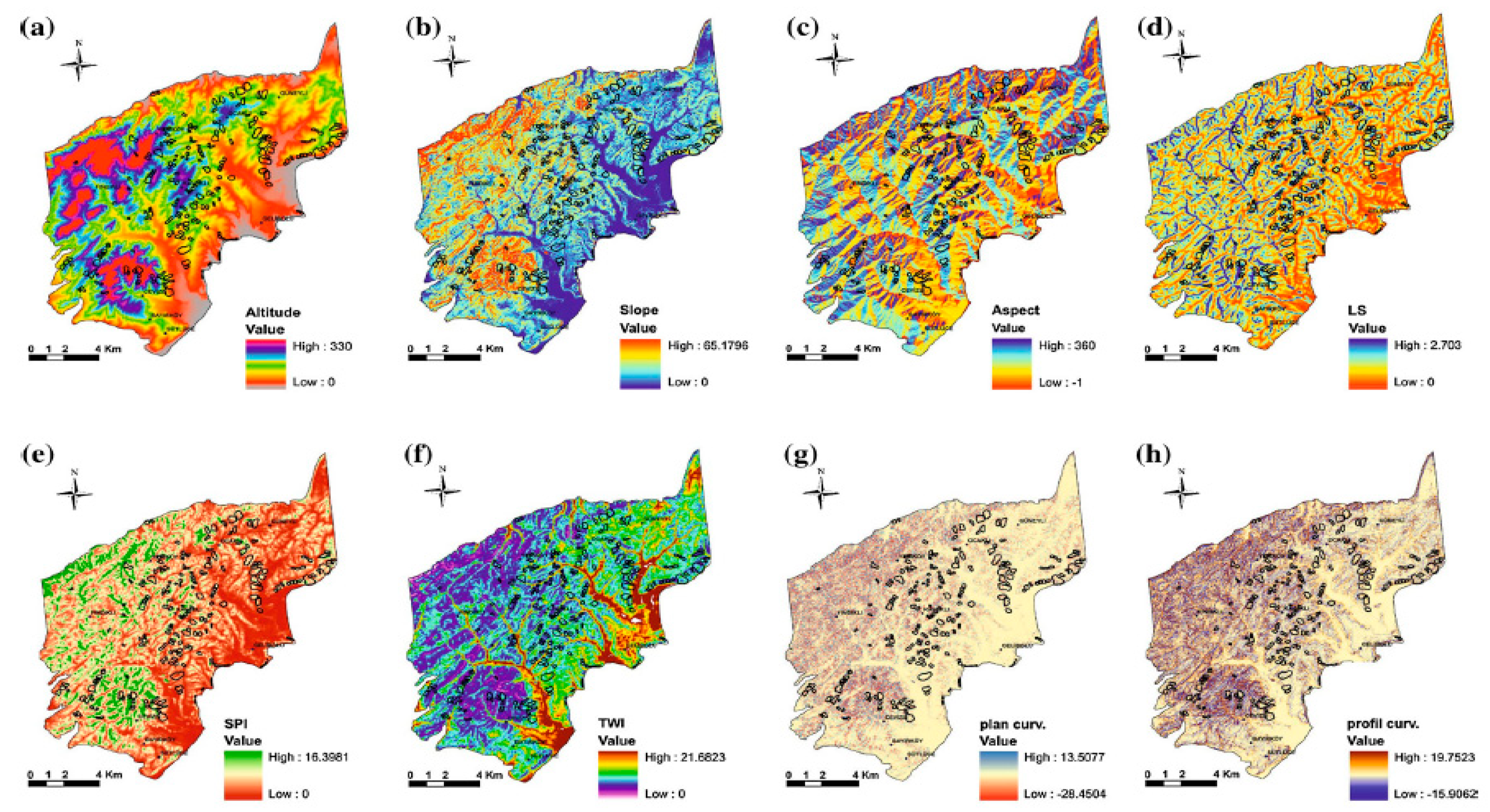
| Parameters | Min. | Max. | Mean | Std. Deviation | Variance | Skewness | |
|---|---|---|---|---|---|---|---|
| Whole Study Area | Elevation | 0 | 330.00 | 97.68 | 68.22 | 4653.99 | 0.68 |
| Slope | 0 | 65.18 | 9.12 | 6.91 | 47.76 | 1.035 | |
| Plan Curvature | −28.45 | 13.51 | 0.01 | 0.41 | 0.17 | −1.82 | |
| Profile Curvature | −15.91 | 19.75 | 0.01 | 0.46 | 0.21 | 0.42 | |
| TWI | 0 | 21.68 | 5.76 | 1.16 | 1.34 | 1.45 | |
| SPI | 0 | 2.70 | 0.55 | 0.39 | 0.15 | 0.98 | |
| STI | 0 | 16.40 | 1.44 | 1.23 | 1.51 | 1.91 | |
| Only Landslide Area | Elevation | 0 | 301.30 | 92.35 | 53.12 | 2821.56 | 0.84 |
| Slope | 0 | 38.65 | 9.95 | 4.69 | 21.96 | 0.80 | |
| Plan Curvature | −3.20 | 2.51 | −0.02 | 0.31 | 0.10 | −0.49 | |
| Profile Curvature | −2.27 | 3.49 | 0.03 | 0.35 | 0.12 | 0.90 | |
| TWI | 4.14 | 7.91 | 5.43 | 0.53 | 0.28 | 0.98 | |
| SPI | 0.03 | 2.16 | 0.65 | 0.31 | 0.28 | 0.77 | |
| STI | 0.92 | 8.40 | 1.67 | 0.87 | 0.76 | 1.50 | |
| Seed cell (buffer distance d = 100 m) | Elevation | 0 | 312.82 | 114.59 | 57.62 | 3320.26 | 0.63 |
| Slope | 0 | 41.47 | 10.08 | 5.48 | 30.04 | 0.82 | |
| Plan Curvature | −3.65 | 3.48 | 0.032 | 0.36 | 0.13 | −0.60 | |
| Profile Curvature | −3.51 | 3.17 | −0.06 | 0.40 | 0.16 | −0.01 | |
| TWI | 4.01 | 9.47 | 5.33 | 0.51 | 0.26 | 0.77 | |
| SPI | 0 | 2.11 | 0.47 | 0.33 | 0.11 | 1.09 | |
| STI | 0 | 7.92 | 1.44 | 0.95 | 0.90 | 1.49 |
| References | Parameters | DEMs | Method | Results |
|---|---|---|---|---|
| Exploited | Data Source | Used | ||
| Carrara et al., (1991) [130] | Altitude, Slope aspect, Geological units | Topographic maps of scale 1:25,000 with 20 m contour interval | Discriminant | Landside hazard risk is evaluated in each slope unit and is declared a cost-effective approach. |
| analyses | Classification Results: | |||
| 83.4% correctly classified | ||||
| 16.6% misclassified. | ||||
| Gao (1993) [58] | Slope orientation, | Topographic maps of scale 1:24,000 with 24 m contour interval | Analyses of landslide and topographic data, chi-squares test | Topographic variable are statistically significant to spatial distribution of the sites disturbed by landslide paths. |
| Slope gradient, | ||||
| Slope form/curvature | ||||
| Pesci et al., (2004) [114] | Landslide morphology, Vegetation, Atmospheric environment and shadows | Photogrammetry, GPS and Laser scanning | Residual comparison analyses | Discussed three techniques are efficient to define landslide topography and morphological changes. |
| Nichol and Wong, (2005) [131] | Slope, Land cover, | Satellite Imagery, Topographic maps with 10 m contour interval | Change detection and Image fusion | Detailed interpretation of landslides and attached features by combining two levels of survey for regional scale landslide monitoring. 70% of landslides were detected in the area with 20 m SPOT images. |
| Geology | ||||
| Yilmaz, (2009) [104] | Elevation, Slope angle, Slope aspect, TWI, SPI, Geology, Faults, Drainage System | Topographic Maps of Scale 1:25,000 | Frequency ratio, Logistic regression, ANN | Susceptibility map obtained from ANN model is more accurate than other models. |
| Validation Results: | ||||
| FR ~82.6%, LR ~84.2%, | ||||
| ANN ~85.2% | ||||
| Miner et al., (2010) [132] | Slope aspect and degree of slope, Plan and profile curvature, Flow accumulation, Terrain hill-shading, TWI, TRI | LiDAR based | Landslide recognition process using DEM | LiDAR-derived DEM has proven itself a cost effective approach against traditional Aerial Photo Interpolation (API) and 10 times large area can be assessed. |
| DEM | ||||
| Pourghasemi et al., (2012) [133] | Slope degree, Slope aspect, Altitude, Lithology, Distance to faults, Distance to rivers, Distance to roads, TWI, SPI, Slope Length, Land use, Plan Curvature | Topographic Maps of Scale 1:25,000 with 10 m contour interval | Index of Entropy and Conditional probability models in GIS | Index of Entropy (IoE) model performed slightly better than conditional probability. |
| Validation Results: | ||||
| IOE model ~86.08%, | ||||
| CP model ~82.75%, | ||||
| Oh et al., (2012) [107] | Slope, Aspect, Curvature, Lineaments, Land cover and NDVI | Aster | Frequency Ratio and Logistic Regression Model | Landslide susceptibility map produced by ASTER DEM is reasonably good with observed accuracy of 25.77 m RMSE. Therefore, ASTER imagery could be exploited for susceptibility. |
| imagery | Validation Results: | |||
| FR model ~84.78%, | ||||
| LR model ~84.20%, | ||||
| Slope, Curvature, | LiDAR derived DEM | Review for landslide, rock fall and debris flow | High resolution DEMs are increasingly being used in landslide community and LiDAR sensors will become a standard tool for landslide analysis in the coming years. However, it will need development of more sophisticated tools for data processing. | |
| Jaboyedoff et al., (2012) [134] | TRI, STI | |||
| Bagherzadeh and Mansouri, (2013) [135] | Geology formations, slope angles, slope aspect, elevation, land use, land cover, mode of failure, rainfall data, drainage network | Digitization survey data, Topographic maps, Satellite images | Factor maps production, Analytic hierarchy process (AHP) | Landslides events are strongly correlated with the slope angle of the basin. Active landslide zones have a high correlation (R2 = 0.769) to slope classes over 30° and 53.85% of the basin is prone to landslides. |
| Martha et al., (2013) [136] | Slope angle, Slope aspect, Land use, Geology, Lithology, Soil depth, Relative relief | Cartosat-I imagery data with 10 m resolution | Semi-automated methods from post-event satellite images, Weights-of-evidence method | Semi-automatically prepared inventories can be used for landslide hazard and risk assessment in a data-poor environment. |
| Pawluszek and Borkowski, (2016) [103] | Elevation, Slope, Morphological gradient, Aspect, Area Solar Radiation, TRI, TWI, TPI, SPI, Shaded relief, Lithology, Distance to road, Drainage networks, Land use | LiDAR derived DEM | Principal component analyses, Weights assignment through Analytical Hierarchy Process (AHP) | Topographic factors play a significant role in landslide susceptibility, however AHP enhanced the results substantially, while adding lithology and environmental factors. |
| B Pradhan and Sameen, (2017) [109] | Slope, Aspect, Altitude, TWI, TRI, NDVI, Vegetation density, Land use, Distance to road, Distance to river, Distance to fault, Plan curvature, Profile Curvature | LiDAR based DEMs, | ROC method, Kappa coefficient, Landslide density graphs, Multicollinearity analysis, Sensitivity analysis | No significant differences have been observed among the prediction and success rates for spatial resolution less than 10 m. LiDAR DEM contains more information even if it has been resampled from 0.5 m DEM. Optimal spatial resolution is 2 m based on the accuracy metrics. |
| ASTER based DEMs | Overall Accuracy: | |||
| ASTER DEM = 82.29% | ||||
| LiDAR DEM = 94.02% | ||||
| Oh et al., (2018) [77] | Slope, Plan curvature, Aspect, TPI, TRI, SPI, TWI, thickness, slope length, Land use, Tree diameter, Tree age, Forest density, Convexity, Mid-Slope position | Topographic maps of scale 1:5000 with 5 m contour interval | Evidential Belief function (EBF), | Training accuracy and prediction accuracy of the LR model was higher than the EBF and SVM model. |
| Logistic Regression (LR), Support Vector Machine (SVM) models | Validation Results: | |||
| EBF model ~92.25%, | ||||
| LR model ~94.59%, | ||||
| SVM model ~81.78% | ||||
| A. Zhu et al., (2018) [137] | Elevation, Slope, Aspect, Plan Curvature, Profile Curvature, Distance to rivers, Distance to road, Lithology, Distance to faults, Land Cover | Topographic maps of scale 1:50,000 | Presence-only method, Presence-absence method, Support Vector Machine (SVM), Kernel Density Estimation (KDE), Artificial Neural Networks (ANN) | Two-class SVM method has the best performance in susceptibility study among the applied methods. Landslide absence data method controlled the over-prediction of the models. |
| Validation Results: | ||||
| 1class-SVM ~70.50%, | ||||
| KDE ~ 72.00%, ANN ~92.90% | ||||
| 2class-SVM ~95.10% | ||||
| Dou et al., (2019) [138] | Slope angle, Slope aspect, Curvature, Distance to drainage network, Drainage density | Satellite imagery based DEM with spatial resolution of 10 m | Advanced Random Forest (RF) and Decision Tree (DT) algorithms | Methods were tested for rainfall-induced landslide susceptibility and overall efficiency of ARF is found better the DT results. |
| Validation Results: | ||||
| ARF model ~95.60%, | ||||
| DT model ~92.80% | ||||
| Juliev et al., (2019) [105] | Slope, Aspect, Elevation, Distance to Lineaments, Geology, Soil, Land use, Land cover, Distance to faults, Distance to roads, Distance to streams | ASTER30 | Statistical Index (SI), Frequency Ratio (FR) and Certainty Factor (CF) model | Landslide susceptibility maps were categorized into five classes i.e., very low, low, moderate, high and very high. Training and prediction accuracies for SI remained higher than the other models. |
| DEM | Validation Results: | |||
| SI ~80%, FR ~70%, CF ~71% |
© 2019 by the authors. Licensee MDPI, Basel, Switzerland. This article is an open access article distributed under the terms and conditions of the Creative Commons Attribution (CC BY) license (http://creativecommons.org/licenses/by/4.0/).
Share and Cite
Saleem, N.; Huq, M.E.; Twumasi, N.Y.D.; Javed, A.; Sajjad, A. Parameters Derived from and/or Used with Digital Elevation Models (DEMs) for Landslide Susceptibility Mapping and Landslide Risk Assessment: A Review. ISPRS Int. J. Geo-Inf. 2019, 8, 545. https://doi.org/10.3390/ijgi8120545
Saleem N, Huq ME, Twumasi NYD, Javed A, Sajjad A. Parameters Derived from and/or Used with Digital Elevation Models (DEMs) for Landslide Susceptibility Mapping and Landslide Risk Assessment: A Review. ISPRS International Journal of Geo-Information. 2019; 8(12):545. https://doi.org/10.3390/ijgi8120545
Chicago/Turabian StyleSaleem, Nayyer, Md. Enamul Huq, Nana Yaw Danquah Twumasi, Akib Javed, and Asif Sajjad. 2019. "Parameters Derived from and/or Used with Digital Elevation Models (DEMs) for Landslide Susceptibility Mapping and Landslide Risk Assessment: A Review" ISPRS International Journal of Geo-Information 8, no. 12: 545. https://doi.org/10.3390/ijgi8120545
APA StyleSaleem, N., Huq, M. E., Twumasi, N. Y. D., Javed, A., & Sajjad, A. (2019). Parameters Derived from and/or Used with Digital Elevation Models (DEMs) for Landslide Susceptibility Mapping and Landslide Risk Assessment: A Review. ISPRS International Journal of Geo-Information, 8(12), 545. https://doi.org/10.3390/ijgi8120545