A Semantic Expansion Model for VGI Retrieval


Abstract
1. Introduction
2. Data Acquisition and Preprocessing
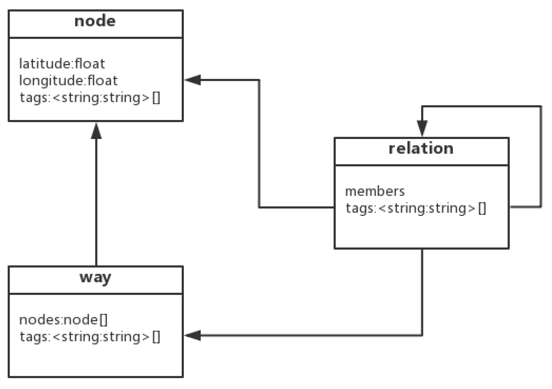
2.1. OSM Dataset
2.2. Property Extraction
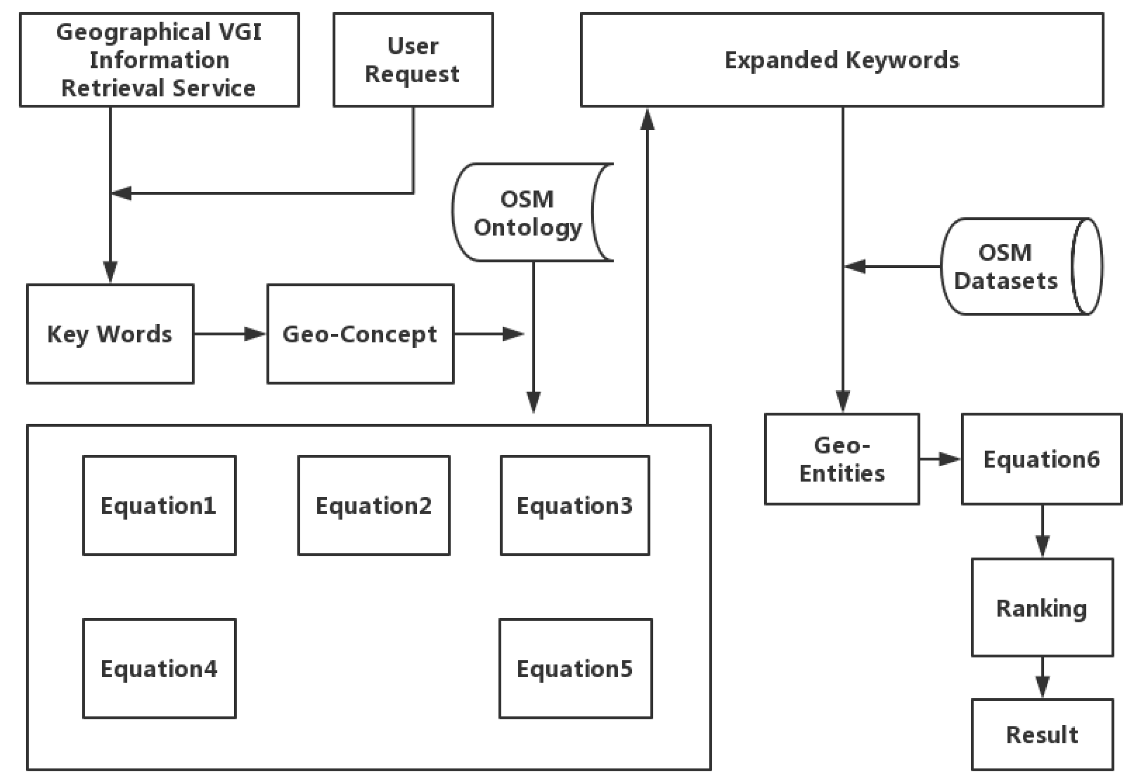
3. Semantic Model for Information Retrieval
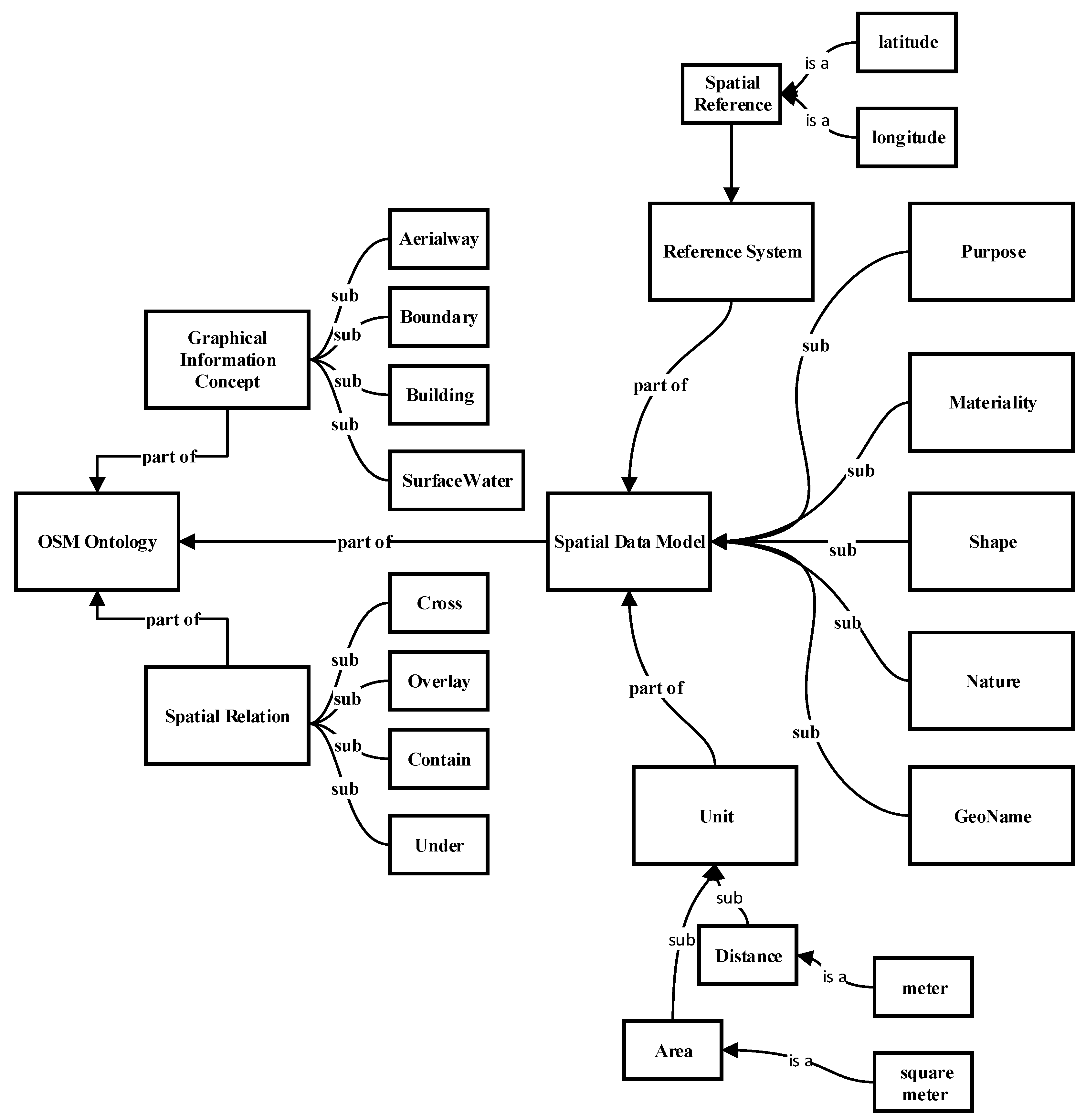
3.1. OSM Ontology Model
3.2. Similarity Query Expansion
3.3. Geo-Data Matching
3.4. Semantic Similarity Calculation Module
3.5. Evaluation Index
4. Results
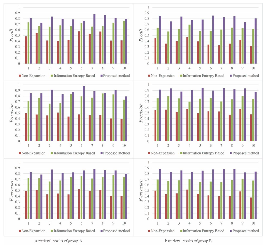
4.1. Recall Rate and Precision Rate
4.2. Top n Results of a Query
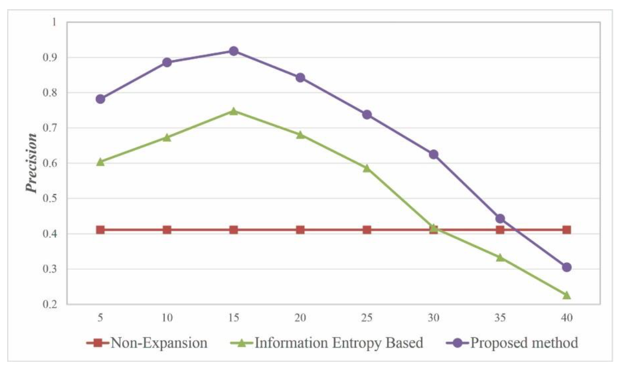
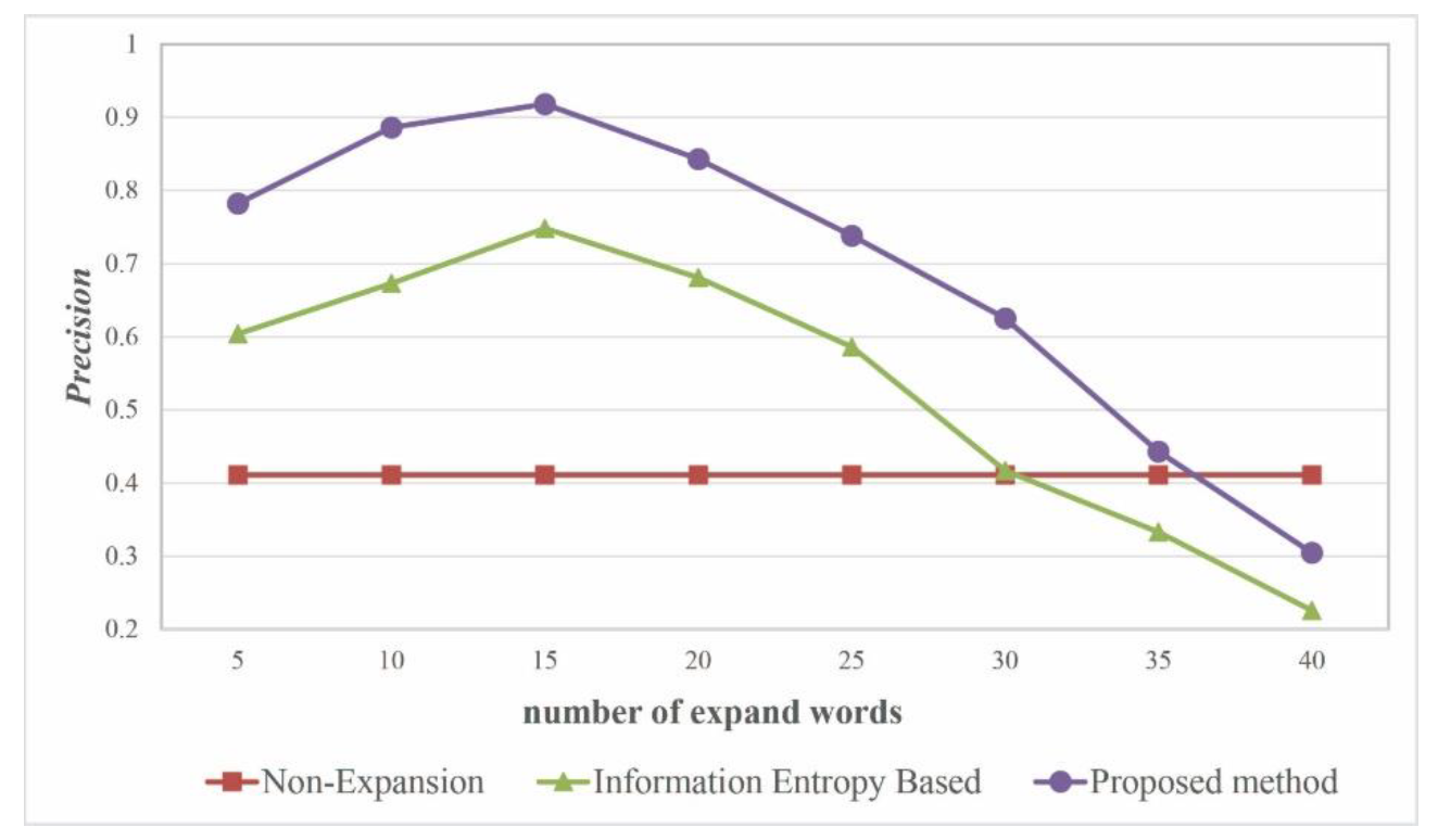
4.3. Optimal Number of Extension Words
5. Discussion
6. Conclusions and Future Work
Author Contributions
Funding
Acknowledgments
Conflicts of Interest
References
- Kobayashi, S.; Fujioka, T.; Tanaka, Y.; Inoue, M.; Niho, Y.; Miyoshi, A. A geographical information system using the google map api for guidance to referral hospitals. J. Med. Syst. 2009, 34, 1157–1160. [Google Scholar] [CrossRef] [PubMed]
- Purves, R.; Jones, C. Geographic information retrieval (gir). Comput. Environ. Urban Syst. 2006, 30, 375–377. [Google Scholar] [CrossRef]
- Jones, C.B.; Alani, H.; Tudhope, D. Geographical Information Retrieval with Ontologies of Place; International Conference on Spatial Information Theory; Springer: Berlin, Heidelberg, 2001; pp. 322–335. [Google Scholar]
- Bergmann, R.; Gil, Y. Similarity assessment and efficient retrieval of semantic workflows. Inf. Syst. 2014, 40, 115–127. [Google Scholar] [CrossRef]
- Wei, C.-P.; Hu, P.J.-H.; Tai, C.-H.; Huang, C.-N.; Yang, C.-S. Managing word mismatch problems in information retrieval: A topic-based query expansion approach. J. Manag. Inf. Syst. 2014, 24, 269–295. [Google Scholar] [CrossRef]
- Singh, J.; Sharan, A. Relevance feedback-based query expansion model using ranks combining and word2vec approach. IETE J. Res. 2016, 62, 591–604. [Google Scholar] [CrossRef]
- Bai, L.; Yan, L.; Ma, Z.M. Determining topological relationship of fuzzy spatiotemporal data integrated with xml twig pattern. Appl. Intell. 2012, 39, 75–100. [Google Scholar] [CrossRef]
- Alazzawi, A.N.; Abdelmoty, A.I.; Jones, C.B. An ontology of place and service types to facilitate place-affordance geographic information retrieval. In Proceedings of the 6th Workshop on Geographic Information Retrieval, Zurich, Switzerland, 18–19 February 2010; pp. 1–2. [Google Scholar]
- Li, L.; Liu, Y.; Zhu, H.; Ying, S.; Luo, Q.; Luo, H.; Kuai, X.; Xia, H.; Shen, H. A bibliometric and visual analysis of global geo-ontology research. Comput. Geosci. 2017, 99, 1–8. [Google Scholar] [CrossRef]
- Cardoso, N.; Silva, M.J. Query expansion through geographical feature types. In Proceedings of the 4th ACM Workshop on Geographical Information Retrieval, Lisbon, Portugal, 9 November 2007; pp. 55–60. [Google Scholar]
- Derbal, K.; Bordogna, G.; Pasi, G.; Alimazighi, Z. Spatial Querying Supported by Domain and User Ontologies: An Approach for Web GIS Applications. In Flexible Query Answering Systems 2015; Springer: Berlin, Heidelberg, 2016; pp. 353–365. [Google Scholar]
- Fu, G.; Jones, C.B.; Abdelmoty, A.I. OTM Confederated International Conferences “on the Move to Meaningful Internet Systems”. In Ontology-Based Spatial Query Expansion in Information Retrieval; Springer: Berlin, Heidelberg, 2005; pp. 1466–1482. [Google Scholar]
- Brown, G.; Kelly, M.; Whitall, D. Which ‘public’? Sampling effects in public participation gis (ppgis) and volunteered geographic information (vgi) systems for public lands management. J. Environ. Plan. Manag. 2014, 57, 190–214. [Google Scholar] [CrossRef]
- OSM. Osm Mapping Projects. Available online: http://wiki.openstreetmap.org/wiki/Mapping_projects (accessed on 27 August 2017).
- Codescu, M.; Horsinka, G.; Kutz, O.; Mossakowski, T.; Rau, R. Osmonto-an ontology of openstreetmap tags. In Proceedings of the State of the Map Europe (SOTM-EU) Conference, Vienna, Austria, 15–17 July 2011. [Google Scholar]
- Lopez-Pellicer, F.J.; Silva, R.J.; Chaves, M. Linkable geographic ontologies. In Proceedings of the 6th Workshop on Geographic Information Retrieval, Zurich, Switzerland, 18–19 February 2010; pp. 1–8. [Google Scholar]
- Janowicz, K.; Schade, S.; Bröring, A.; Keßler, C.; Maué, P.; Stasch, C. Semantic enablement for spatial data infrastructures. Trans. GIS 2010, 14, 111–129. [Google Scholar] [CrossRef]
- Kauppinen, T.; Henriksson, R.; Sinkkilä, R.; Lindroos, R.; Väätäinen, J.; Hyvönen, E. Ontology-Based Disambiguation of Spatiotemporal Locations; IRSW: Tenerife, Spain, 2008. [Google Scholar]
- Carpineto, C.; Romano, G. A survey of automatic query expansion in information retrieval. ACM Comput. Surv. CSUR 2012, 44. [Google Scholar] [CrossRef]
- Ballatore, A.; Bertolotto, M.; Wilson, D.C. Geographic knowledge extraction and semantic similarity in openstreetmap. Knowl. Inf. Syst. 2013, 37, 61–81. [Google Scholar] [CrossRef]
- Zhu, X. A novel wordnet-based approach for measuring semantic similarity. J. Inf. Comput. Sci. 2015, 12, 4919–4927. [Google Scholar] [CrossRef]
- Gao, J.-B.; Zhang, B.-W.; Chen, X.-H. A wordnet-based semantic similarity measurement combining edge-counting and information content theory. Eng. Appl. Artif. Intell. 2015, 39, 80–88. [Google Scholar] [CrossRef]
- Liu, H.; Bao, H.; Xu, D. Concept vector for semantic similarity and relatedness based on wordnet structure. J. Syst. Softw. 2012, 85, 370–381. [Google Scholar] [CrossRef]
- Ponniah, P. Data Normalization Method. In Database Design and Development; IEEE Press: Piscataway, NJ, USA, 2015. [Google Scholar]
- Cao, J.; Wu, -X.; Xia, Y.; Zheng, F. Pinyin-indexed method for approximate matching in Chinese. J. Tsinghua Univ. Sci. Technol. 2009, S1, 1328–1332. (In Chinese) [Google Scholar]
- Wu, Z.-Q. The Development of Post-Control Words during Economical Information Retrieval. Master’s Thesis, Nanjing Agricultural University, Nanjing, China, 1999. [Google Scholar]
- An, X.-Y.; Sun, Q.; Xiao, Q. A Shape Multilevel Description Method and Application in Measuring Geometry Similarity of Multi-scale Spatial Data. Acta Geod. Cartogr. Sin. 2011, 40, 495–502. [Google Scholar]
- Li, L.; Xing, X.; Xia, H.; Huang, X. Entropy-weighted instance matching between different sourcing points of interest. Entropy 2016, 18, 45. [Google Scholar] [CrossRef]
- Büttcher, S.; Clarke, C.L.; Cormack, G.V. Information Retrieval: Implementing and Evaluating Search Engines; MIT Press: Cambridge, MA, USA, 2016. [Google Scholar]
- Spink, A.; Wolfram, D.; Jansen, M.B.J.; Saracevic, T. Searching the web: The public and their queries. J. Am. Soc. Inf. Sci. Technol. 2001, 52, 226–234. [Google Scholar] [CrossRef]
- Karypis, G. Evaluation of Item-Based Top-N Recommendation Algorithms. In Proceedings of the Tenth International Conference on Information and Knowledge Management (CIKM), Atlanta, GA, USA, 5–10 November 2001. [Google Scholar]


| Category | Ontology Properties/Keys | Examples |
|---|---|---|
| GeoName | GeoName | Wuhan University |
| materiality | materiality | solid and sand |
| cause | cause | natural |
| spatial morphology | structure | multi-story |
| shape | multi-line | |
| orientation | northern | |
| spatial relation | beside | |
| spatial location | locality | Hubei province |
| position | longitude; latitude | |
| temporality | cyclicity | seasonal |
| lifecycle | scrapped | |
| function | function | transportation |
| specificity | specificity | affiliated |
| measurement | measurement | height |
| hierarchy | hierarchy | part-of; subclass; kind-of |
| Materiality | Formative | Spatiality | Timeliness | Feature | ||
|---|---|---|---|---|---|---|
| Space Shape | Spatial Location | Periodicity | Life Cycle | |||
| Water | Natural | Pit shape | Land surface | No | Normal period | Flowing water, |
| storage water, | ||||||
| aquaculture | ||||||
| Group | Geo-Names | Geo-Entities | ||
|---|---|---|---|---|
| Key Words | Location | Key Words | Location | |
| 1 | Optics Valley Square | Hubei Province | Moon Lake | Hubei Province |
| 2 | Wuhan University | Hubei Province | Yangtze Grand Bridge | Hubei Province |
| 3 | Three Gorges Dam | Hubei Province | Highway No. S14 | Hubei Province |
| 4 | Sun Yat-Sen Mausoleum | Jiangsu Province | Tianhe Airport | Hubei Province |
| 5 | Old Summer Palace | Beijing | Hongli Road | Shenzhen |
| 6 | Canton Tower | Guangzhou | Yalu River | Jiling Province |
| 7 | West Lake | Zhejiang Province | East Third Ring Road | Beijing |
| 8 | Ultima Thule | Hainan Province | Wanquan River | Hainan Province |
| 9 | The Bund | Shanghai | Five Old Men Peaks | Jiangxi Province |
| 10 | Potala Palace | Tibet | Desert Road | Xinjiang |
| Retrieval Method | Mean Recall | Mean Precision | Mean F-measure |
|---|---|---|---|
| Non-Expansion | 43% | 49.2% | 45.9% |
| Information Entropy-Based | 65.4% | 75.8% | 70.2% |
| Semantic-Based (Proposed) | 80.5% | 89.3% | 84.7% |
© 2019 by the authors. Licensee MDPI, Basel, Switzerland. This article is an open access article distributed under the terms and conditions of the Creative Commons Attribution (CC BY) license (http://creativecommons.org/licenses/by/4.0/).
Share and Cite
Sun, T.; Xia, H.; Li, L.; Shen, H.; Liu, Y. A Semantic Expansion Model for VGI Retrieval. ISPRS Int. J. Geo-Inf. 2019, 8, 589. https://doi.org/10.3390/ijgi8120589
Sun T, Xia H, Li L, Shen H, Liu Y. A Semantic Expansion Model for VGI Retrieval. ISPRS International Journal of Geo-Information. 2019; 8(12):589. https://doi.org/10.3390/ijgi8120589
Chicago/Turabian StyleSun, Tao, Hui Xia, Lin Li, Hang Shen, and Yu Liu. 2019. "A Semantic Expansion Model for VGI Retrieval" ISPRS International Journal of Geo-Information 8, no. 12: 589. https://doi.org/10.3390/ijgi8120589
APA StyleSun, T., Xia, H., Li, L., Shen, H., & Liu, Y. (2019). A Semantic Expansion Model for VGI Retrieval. ISPRS International Journal of Geo-Information, 8(12), 589. https://doi.org/10.3390/ijgi8120589